


Chapter 16.04
TITLE, AUTHORITY AND DEFINITIONS
Sections:
16.04.040 Adoption of figures.
16.04.050 Adoption of appendices and maps.
16.04.010 Short title.
These regulations shall be known and may be cited as the "Town of Pinetop-Lakeside Subdivision Ordinance" and will be referred to herein as "this code," or "this Ordinance." (Ord. 15-392 § 1 (part))
16.04.020 Authority.
This Ordinance is adopted pursuant to the authority contained in the Arizona Revised Statutes (A.R.S.) § 9-463.01, et seq. (Ord. 15-392 § 1 (part))
16.04.030 Purpose and intent.
A. The purpose of this Ordinance is to provide for the orderly growth and harmonious development of the Town of Pinetop-Lakeside; to ensure adequate vehicular and pedestrian traffic circulation through coordinated street systems with relation to major thoroughfares, adjoining subdivisions, and public facilities; to achieve individual property lots of reasonable utility and livability; to secure adequate provisions for water supply, drainage, flood protection, sanitary sewage, and other health and safety requirements; to ensure consideration for adequate sites for schools, unbuilt lot area, recreation areas, and other public facilities; to help ensure that emergency services such as fire, ambulance and police services can be provided to all developed land; to promote the conveyance of land by accurate legal description; and to provide practical procedures for the achievement of this purpose.
B. In the interpretation and application of this Ordinance, it is intended that a common ground of understanding and a sound and equitable working relationship exist between the public and private interests and to this end, the independent and mutual objectives of the public and private interests can be achieved in the subdivision of land. (Ord. 15-392 § 1 (part))
16.04.040 Adoption of figures.
All figures within this Ordinance are hereby adopted and shall be incorporated herein as a part of this Ordinance. (Ord. 15-392 § 1 (part))
16.04.050 Adoption of appendices and maps.
All appendices and maps within this Ordinance are hereby adopted and shall be incorporated herein as a part of this Ordinance. (Ord. 15-392 § 1 (part))
16.04.060 Definitions.
1. "Abutting" is the condition of two (2) adjoining properties having a common property line or boundary, including cases where two (2) or more lots adjoin only at a corner(s).
2. "Accessory use" is a use, building, structure, part of a building, or part of a structure which is subordinate to, and the use of which is incidental to, that of the main building, structure or use on the same lot, including a private garage. If a building otherwise qualified as an accessory building is attached to the main building by a common wall or roof, such building shall be considered part of the main building.
3. "Alley" means a public way, other than a street, which affords a secondary means of vehicular access to abutting property and is not intended for general traffic circulation.
4. "Alter the mountain top ridge line" means any development on the primary ridgeline that disturbs or alters the natural mountain top profile (see Chapter 16.20, Mountainside Development, and Chapter 17.96, Forest Health and Fire Protection).
5. "Average lot slope" means the average slope of the natural terrain within the boundaries of a particular lot. The slope will be calculated by taking the average of a minimum of three (3) slope lines per lot. These slope lines shall run the entire length of the lot and be as near to perpendicular as practical to the natural contour lines (see Chapter 16.20).
6. "Basal area" is a measurement of tree density (see Chapter 16.20, Mountainside Development, and Chapter 17.96, Forest Health and Fire Protection).
7. "Basin, detention" is a storm water storage facility that temporarily stores surface runoff and releases it at a controlled rate through a positive outlet. A detention basin and park may be joined to serve both recreational needs and as a water storage facility.
8. "Basin, drainage" is a geographical area that contributes surface runoff to a particular concentration point. The terms "drainage basin," "tributary area" and "watershed" are used interchangeably.
9. "Basin, retention" is a storm water storage facility that stores surface runoff. Stored water is infiltrated into the subsurface or released to the downstream drainage system or watercourse (via gravity outlet or pump), or evaporated after the storm event. A retention basin and park may be joined to serve both recreational needs and as a water storage facility.
10. "Berm" means an earthen mound, either natural or man-made.
11. "Bicycle lane" means a paved area located within a street right-of-way and between the curbs that is designated for bicycle or other nonmotorized traffic.
12. "Bicycle trail" means a paved or improved surfaced trail, located outside of a street right-of-way, utilized for bicycle, pedestrian or other nonmotorized traffic. Public utility maintenance vehicles may be permitted use if joint access is allowed.
13. "Bicycle path" means a paved area located within a street right-of-way but not between curbs that is designated for bicycle or other nonmotorized traffic.
14. "Block" means a piece or parcel of land or group of lots entirely surrounded by public or private streets, streams, washes, parks, or a combination thereof of sufficient magnitude as to interrupt the continuity of development.
15. "Board of Adjustment" means the Board of Adjustment for the Town of Pinetop-Lakeside.
16. "Buffering" means an area of land, including landscaping, berms, walls and fences but not building setbacks, which is located between land uses of different character or density and is intended to mitigate negative impacts of the more intense use on residential or vacant parcels.
17. "Buildable" means a lot or parcel that has the area, shape, slope, street frontage, or other attribute in order for a permitted use, based on the lot or parcel’s zoning district, to be developed, without the need for any variance from the Town Zoning Ordinance.
18. "Building pad and slope" is the percent of slope measured at right angles to the natural contours along a line passing through the center of the proposed building and terminating at the end of the disturbed area limits of the building site (see Chapter 16.20).
19. "Building setback line" means the required minimum distance, as prescribed by the Zoning Ordinance, between the property line and the closest point of any building or structure.
20. "Bus stops (school)" means areas designated by the School District as needed for the convenience and safety of the students and public per R17-9-104.
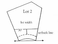
21. "Chord" means a straight line joining two (2) points on a curve.
22. "Cluster development" means a development pattern that concentrates development in specific areas on a site through a density transfer rather than distributed evenly throughout a parcel as in conventional lot-by-lot development with the remaining portion of the site retained as natural unbuilt common area or parks.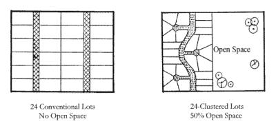
23. "Commission" means the Planning and Zoning Commission of the Town of Pinetop-Lakeside.
24. "Committee" means the Development Review Committee of the Town of Pinetop-Lakeside.
25. "Conditional approval" means an affirmative action by the Commission or Council indicating that approval will be forthcoming with satisfaction of certain specified conditions or stipulations.
26. "Condominium" (see also "time-share unit") means real estate, portions of which are designated for separate ownership and the remainder of which is designated for common ownership solely by the owners of the separate portions. Real estate is not a condominium unless the undivided interests in the common elements are vested in the unit owners. The term "condos" may also be used in the Ordinance.
27. "Conservation easement" means a permanent unbuilt lot area easement granted to the Town or to a public land trust to prohibit development of the property, including roads and utilities, and to protect archaeological sites, ecologically significant lands, scenic highways, hiking trails, biking trails, equestrian trails, and to preserve the land for the scenic enjoyment of the general public.
28. "Conventional development" means a development other than a planned unit development or a cluster development.
29. "Council" means the Town Council of the Town of Pinetop-Lakeside.
30. "County" means Navajo County, Arizona.
31. "Cut" means the removal of soil, rock, or other materials from a location which shapes and lowers the grade at the location.
32. "Defensible space" means the area around a building that is intentionally maintained to provide a separation of the building from non-fire-resistant vegetation to help prevent the spread of fire (see Chapter 16.20).
33. "Department" means the Community Development Department of the Town of Pinetop-Lakeside.
34. "Developer" (see also "subdivider") means a person, firm, partnership, joint venture, trust, syndicate, association, corporation, limited liability company or other legal entity who desires to improve or otherwise engage in any development of property within the Town of Pinetop-Lakeside, including the owner of the property; except that an individual serving as agent for such legal entity is not a developer.
35. "Development" means the utilization of land for public or private purposes.
36. "Development Review Committee" means the selected group of technically qualified individuals, appointed by the Director, made up of Town Staff and other public or private agencies and utility company representatives responsible to ensure compliance with Town ordinances, codes and standards as they relate to the subdivision process.
37. "Director" means the Community Development Director of the Town of Pinetop-Lakeside.
38. "Disturbed area" means that area of natural ground, including the footprint of the residence, that has been or is proposed to be altered through grading, cut and fill, removal of natural vegetation, placement of material, trenching, or by any means that causes a change in the undisturbed natural surface of the land or natural vegetation.
39. "Easement" means a grant by the owner of the use of land by the public, a corporation, or person for the specific uses designated.
40. "Engineer" means the Engineer of the Town of Pinetop-Lakeside or his designated representative.
41. "Engineering Department" means the Engineering Department of the Town of Pinetop-Lakeside.
42. "Exception" means any parcel of land that is not owned by the developer or not included in the recorded plat. All such exceptions must be noted on the final plat as "not a part of this subdivision."
43. "Figure" means any graphic representation noted as "Figure" within this Ordinance, which is used to illustrate and exemplify certain standards and regulations contained within the language of this Ordinance. If a figure and text of the Ordinance conflict, the written text of the Ordinance shall control.
44. "Fill" means soil, rock, or other material deposited at a location by man that raises the grade at that location.
45. "Finished grade" means the final grade and elevation of the ground surface after grading is completed and in conformance with the approved grading plans.
46. "Flood hazard zone" means any land area partially or wholly within a delineated floodplain susceptible to flood-related damage as designated on the flood management maps. Such flood hazard zones may include, but not be limited to, areas highly susceptible to erosion, stream meander sensitivity, moveable bed, scour, wave action, and subsidence.
47. "Floodplain" means low lands adjoining the channel of a river, stream or watercourse, lake or other body of water, which have been or may be inundated by floodwater, and those other areas subject to flooding. A floodplain may be that area further defined by the drainage policy of the Town of Pinetop-Lakeside and as shown on Federal Emergency Management Agency (FEMA) Flood Insurance Rate Maps (FIRMs) or an approved flood control study.
48. "Flood prone area" means any area within a floodplain.
49. "Floodway" means the channel of a wash or other watercourse and the adjacent land areas that must be reserved in order to discharge the one hundred (100) year flood without cumulatively increasing the water surface elevation more than one (1) foot.
50. "Fuel modification" means changing the type or amount of plant fuels to reduce fire danger (see Chapter 16.20).
51. "General plan" means the municipal statement of land development policies, which may include maps, charts, graphs and text which set forth objectives, principles and standards for local growth and redevelopment enacted under the provisions of A.R.S. § 9-461 et seq.
52. "Health Department" means the Navajo County Health Department.
53. "Improvements" means required installations, pursuant to this Subdivision Ordinance and any zoning stipulations, including but not limited to grading, sewer, water, utilities, streets, curbs, gutters, sidewalks, trails, alleys, street lights, traffic control devices and landscaping, as a condition to the approval and signing of the final plat, before recordation.
54. "Improvement plans" means a set of plans setting forth the profiles, cross-sections, details, specifications, instructions and procedures to be followed in the construction of public or private improvements in the Town of Pinetop-Lakeside that are prepared and bear the seal of an Arizona-registered land surveyor, engineer, architect or landscape architect in accordance with the approved preliminary plat, and zoning stipulations, and in compliance with standards of design and construction that are to be approved by the Town Engineer, other Town departments, the applicable county departments, and all applicable utilities.
55. "Improvements standards" means a set of regulations and exhibits setting forth the details, specifications and instructions to be followed in the design and construction of required improvements.
56. "Irrigation facilities" includes laterals, ditches, conduits, pipes, gates, pumps and allied equipment necessary for the supply, delivery and drainage of irrigation water and the construction, operation and maintenance of such.
57. "Ladder fuels" means living or dead trees, bushes and grasses that allow a fire to travel from the ground to the forest or tree canopy (see Chapter 16.20).
58. "Land/lot splits" means the division of improved or unimproved land, the area of which is two and one-half (2-1/2) acres or less, into two (2) or three (3) parcels of land for the purpose of sale, lease, or conveyance.
59. "Lot" means a single piece of property having frontage on a publicly dedicated and accepted street or a private road approved and accepted by the Town and which has been established by a plat, recorded subdivision or otherwise established by some legal instrument of record which is described and denoted as such.
60. "Lot area" means the area of a horizontal plane within the lot lines of a lot but not including any area in a public way.
61. "Lot corner" means the intersection of two (2) or more lot lines, or angle point or change in direction of a lot line.
62. "Lot, corner" means a lot located at the intersection of two (2) or more streets.
63. "Lot coverage" means the percentage of the area of a lot that is occupied by all buildings or other covered structures using the roof outline for all outer dimensions.
64. "Lot depth" means the horizontal length of a straight line connecting the midpoints of the front and rear lot lines; and for triangular shaped lots, the shortest horizontal distance between the front lot line and a line within the lot, parallel to and at a maximum distance from the front lot line, having a length of not less than ten (10) feet.
65. "Lot, improvement" means any building, structure, place, work of art or other object or improvement of the land on which they are situated constituting a physical betterment of real property.
66. "Lot, interior" means a lot other than a corner lot.
67. "Lot, key" means a lot adjacent to a corner lot having its side lot line in common with the rear lot line of the corner lot and fronting on the street that forms the side boundary of the corner lot.
68. "Lot line" means a line dividing one (1) lot from another or from a street or any public place.
69. "Lot line, front" means, in the case of an interior lot, a line separating the lot from the street right-of-way. In the case of a corner lot, the narrower of the two (2) lot lines adjoining a street right-of-way.
70. "Lot line, rear" means a lot line which is opposite and most distant from the front lot line; except that in the absence of a rear lot line as is the case of the triangular shaped lot, the rear lot line may be considered as a line within the lot, parallel to and at a maximum distance from the front lot line, having a length of not less than ten (10) feet.
71. "Lot line, side" means the boundary of a lot that is not a front lot line or a rear lot line.
72. "Lot, through" means a lot having a part of opposite lot lines abutting two (2) streets, and which is not a corner lot (also known as a "double frontage lot"). On such lot, both lot lines are front, except that where a nonaccess easement has been established on such a lot, the front lot line shall be considered as that lot line most distant from the lot line containing the nonaccess easement.
73. Lot Width.
a. For rectangular lots, lots having side lot lines not parallel, and lots on the outside of the curve of a street, the distance between side lot lines measured at the required minimum front yard setback line on a line parallel to the street or street chord;
b. For lots on the inside of the curve of a street, the distance between side lot lines measured thirty (30) feet behind the required minimum front yard setback line on a line parallel to the street or street chord.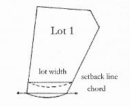
74. "Mountain top" means the highest point on a mountain with a minimum of two hundred fifty (250) feet relief from its base to its highest peak (see Chapter 16.20).
75. "Mountainside development area" means those lands where the natural terrain has a slope of fifteen (15%) percent or greater. This does not include a fifteen (15%) percent or greater slope, created by a natural wash, on land that otherwise would not be classified as mountainside land (see Chapter 16.20).
76. "Mountainside wash" means any creek, stream, wash, channel, or other body of water having historical banks and with a flow rate equal to or greater than two (2) cubic feet per second based on a one hundred (100) year storm event (see Chapter 16.20).
77. "Natural features, significant" includes washes, significant vegetation, and significant rock outcroppings, provided these features are in their undisturbed natural state (see Chapter 16.20).
78. "Natural grade" means the undisturbed natural surface of the land, including washes.
79. "Net acres" means the total acreage of a tract or parcel of land exclusive of the area existing or required for arterial or collector street right-of-way dedications and school/public site reservations. When calculating residential net acres within a neighborhood PUD, any commercially zoned land must be excluded in addition to those uses listed above.
80. "Non-fire-resistant vegetation" includes trees and other plant material, dead or alive, which increase the fire danger to unreasonably high levels (see Chapter 16.20).
81. "Off site" means not located within the area of the property to be developed.
82. "Unbuilt common area, active" means any parcel or area of land or water designated as an amenity or for recreational purposes and may consist of improved landscaped areas, parks, playgrounds, seating areas, or areas otherwise designed to be consistent with recreational uses. Active unbuilt common area is designated and reserved for the use and enjoyment of all the residents of the development.
83. "Unbuilt common area, passive" means unbuilt common area within a development primarily used for drainage, detention basins, and tracts of land which are not explicitly designated for recreational purposes. Passive unbuilt common area is designated and may be owned in common by all property owners in that development.
84. "Unbuilt common area, preserved" means unbuilt common areas required for the preservation and conservation of plant and animal life, including habitat for fish and wildlife species; areas required for ecological and/or cultural purposes; and areas required to preserve natural drainage or floodplain. The developer is encouraged to preserve environmentally sensitive areas to the greatest extent possible. Preserved unbuilt common area is designated for long-term benefit.
85. "Owner" means the person or persons holding title by deed to land, or holding title as vendor under a land contract, or holding any other title of record.
86. "Parks" means a public tract of land that contains a mix of active and passive recreation facilities including tot lots, defined and improved play fields and/or sport court areas, and picnic/seating/shade areas that are landscaped/hardscaped in a pleasing manner.
87. "Pathway" means a path, course, route, track, footway and equestrian trail.
88. "Pedestrian way" means a public walk dedicated entirely through a block from street to street and/or providing access to a school, park, recreation area, trail system, or shopping area.
89. "Planned unit development (PUD)" means a development in which flexibility can be permitted in the zoning standards, in order to encourage more creativity and sustainable design, thereby providing usable unbuilt common area within and about the development and enhancing the residential character of the Town.
90. "Plat" means a map that provides for changes in land use or ownership.
a. "Preliminary plat" means a tentative map, including supporting data, indicating a proposed subdivision design, prepared by a registered civil engineer, or a registered land surveyor, in accordance with this Ordinance and the Arizona Revised Statutes. A preliminary site plan for a condominium development shall be considered a preliminary plat.
b. "Final plat" means a final map of all of a subdivision, including supporting data, in substantial conformance to an approved preliminary plat and all stipulations or conditions placed upon it by the Commission or Council, prepared by a registered land surveyor, in accordance with this Ordinance and the Arizona Revised Statutes.
c. "Recorded plat" means a final plat bearing all certificates of approval required by this Ordinance and the Arizona Revised Statutes and duly recorded in the Navajo County Recorder’s Office.
d. Reversionary Plat.
i. A plat for the purpose of reverting previously subdivided acreage to unsubdivided acreage; or
ii. A plat for the purpose of vacating rights-of-way previously dedicated to the public and abandoned under procedures prescribed by the Town Code; or
iii. A plat for the purpose of vacating or redescribing lot or parcel boundaries previously recorded.
91. "Pre-application meeting" means an initial meeting between developer and municipal representatives that affords developers the opportunity to present their proposals informally and discuss the project and address any items of controversy or requirements before the preliminary plat is submitted.
92. "Preliminary approval" means affirmative action on a preliminary plat, noted upon prints of the plat, indicating that approval of a final plat will be forthcoming upon satisfaction of specified stipulations; and which constitutes authorization to submit final engineering plans and the final plat.
93. "Primary ridge line" means the line running from the highest peak on a mountain top to the next highest peak along a natural ridge (see Chapter 16.20).
94. "Private access way" means a private way of access dedicated as a tract to one (1) or more lots or air spaces, which is owned and maintained by an individual or group of individuals and has been improved in accordance with Town standards and plans approved by the Town Engineer. A private access way is intended to apply where its use is logically consistent with a desire for neighborhood identification and control of access, and where special design concepts may be involved, such as within planned unit developments and condominiums.
95. "Protected development rights plan" means a final subdivision plat that meets all the requirements of this Ordinance and A.R.S. § 9-463.01, and which has been recorded with the County Recorder.
96. "Recorder" means the Recorder of Navajo County.
97. "Right-of-way" means any public or private access way required for ingress or egress, including any area required for public use pursuant to any official plan; rights-of-way may consist of fee title dedications or easements.
98. "Roadway easement" means a recorded conveyance to the public over a described area for roadway related uses.
99. "Rock outcroppings, significant" means any surface rock or group formation of rocks covering an area of two hundred (200) square feet or larger or any surface rock formation with a height greater than ten (10) feet from the surrounding grade (see Chapter 16.20).
100. "Service easement" means an area provided for in the subdivision design at the rear of retail, commercial or multi-family dwelling use of sufficient size and accessibility to facilitate the provision of necessary services.
101. "Sidewalk" means a five (5) foot wide pedestrian way constructed of portland cement concrete.
102. "Sketch plan" means a preliminary presentation of a proposed subdivision or site plan of sufficient accuracy to be used for discussion purposes and identification of any items of controversy or issues of concern.
103. "Staging area" means a trailhead specifically designed to accommodate equestrians. It includes areas for horse trailer parking, and facilities for hitching, mounting, and watering horses.
104. "Street, arterial" means arterial streets to provide a high level of mobility for Town-wide through traffic movement and are typically spaced at one (1) mile or greater intervals, have limited access, and no on-street parking. The locations of arterial streets are designated in the Pinetop-Lakeside general plan.
105. "Street, collector" means the collector streets provide mobility and access and link the arterial and local roadways as well as allowing access to adjacent properties.
106. "Street, cul-de-sac" means a local street having one (1) end permanently terminated in a vehicular turnaround, or an equally convenient form of turning, with backing areas as may be recommended by the Town Engineer.
107. "Street, frontage" means a local street parallel to an arterial or collector road which intercepts the residential traffic and controls access to the arterial and collector roads.
108. "Street, local" provides for direct access to residential or other abutting land and serves local traffic movement with connections to roadways of higher classification.
109. "Street, private" means any road or street that is not publicly owned and maintained providing access to lots or units over a common parcel, primarily by the owners or occupants of the common parcel, and necessary service and emergency vehicles, but from which the public may be excluded.
110. "Subdivider" (see also "developer") means a person, firm, corporation, partnership, limited liability company, association, syndicate, trust, or other legal entity that files the application and initiates proceedings for a subdivision in accordance with the provisions of this Ordinance and statutes of the State of Arizona, except that an individual serving as agent for such legal entity is not a developer; and said developer need not be the owner of the property as defined by this Ordinance. The Town Council may itself prepare or have prepared a plat for the subdivision of land under municipal ownership.
111. Subdivision.
a. Improved or unimproved land or lands divided for the purpose of financing, sale, lease, or conveyance, whether immediate or future, into four (4) or more lots, tracts or parcels of land; or, if a new street is involved, any such property which is divided into two (2) or more lots, tracts or parcels of land; or, any such property, the boundaries of which have been fixed by a recorded plat, which is divided into two (2) or more parts. "Subdivision" also includes any condominium, cooperative, community apartment, townhouse, patio home, or similar project containing four (4) or more parcels, in which an undivided interest in the land is coupled with the right of exclusive occupancy of any unit located thereon.
b. "Subdivision" does not include the following:
i. The sale or exchange of parcels of land between adjoining property owners if such sale or exchange does not create additional lots.
ii. The partitioning of land in accordance with other statutes regulating the partitioning of land held in common ownership.
iii. The leasing of apartments, offices, stores or similar space within a building or trailer park, nor to mineral, oil, or gas leases.
112. "Technical review" means the detailed review of proposed preliminary plats, by the Development Review Committee, for compliance with Town codes, ordinances, standards, or conditions of approval by the Commission or Council. Other utilities and public agencies are invited to review the plat as it relates to their conditions of service or need.
113. "Time-share unit" (see also "condominium") means a right of occupancy in a time-share project, condominium or multiple residence unit, which is owned, occupied, or possessed, under either interval ownership or fractional fee interests as may be determined by the Town Council.
114. "Town" means the Town of Pinetop-Lakeside, Arizona.
115. "Townhouse" means a building on its own separate lot containing one (1) dwelling unit that occupies space from the ground to the roof, and is attached to one (1) or more other townhouse dwelling units by at least one (1) common wall. Shall also mean patio home.
116. "Trail, multi-use" means a hard surfaced trail designed for all types of nonmotorized use. These trails should be constructed of either concrete or an all-weather surface such as rubberized asphalt, or similar material.
117. "Trail, unpaved" means a designated trail designed to accommodate primarily equestrians, off-road bicycles, and pedestrian users.
118. "Trailhead" means a trailhead that serves as the beginning point of a trail and must include parking and trail information and may also include trash receptacles, water, sanitary facilities and shade structures/ramadas (refer to the "Urban Element of the White Mountain Trailsystem").
119. "Urban-wildlife interface" means the area where buildings, structures and people come together and mix with the forest or non-fire-resistant vegetation (see Chapter 16.20).
120. "Usable lot area" means that portion of a lot usable for, or adaptable to, the normal uses made of property, excluding any areas which may be covered by water, are excessively steep, or are included in certain types of easements. Areas covered by water shall include areas within the defined flood plain, flood prone areas, or are within the perimeter of a given pond of water that will remain after the development is completed.
121. "U.S.C. and G.S." means the United States Coast and Geodetic Survey.
122. "U.S.A.C.O.E." means the United States Army Corp of Engineers.
123. "Utility services" means the service to the public of water, sewer, gas, electricity, telephone and cable television. The foregoing shall be deemed to include facilities and appurtenances to the above uses but shall not include public utility treatment and generating plants or offices.
124. "Vegetation, significant" is considered to be a stand of trees having a height greater than fifteen (15) feet or three (3) or more trees, located within a radius of fifteen (15) feet, each having a height greater than fifteen (15) feet.
125. "View fencing (view fence)" shall mean fencing that is constructed in such a manner as to achieve eighty (80%) percent overall openness.
126. "Watercourse" means any lake, river, stream, creek, wash, arroyo, or other body of water or channel having banks and bed through which waters flow at least periodically.
127. "Water supply, adequate" means a written statement from the water company, providing water to the subdivision, that states the water supply and flows are adequate and in accordance with Town and the Fire District’s requirements.
128. "Zone" means a district classification established by the Zoning Ordinance of the Town of Pinetop-Lakeside that limits or permits various and specific uses.
129. "Zoning clearance" means the approval by the Director of a plan that is in conformance with the Zoning Ordinance of the Town of Pinetop-Lakeside.
130. "Zoning district" means a zone area in which the same zoning regulations apply throughout the district.
131. "Zoning Ordinance" means the Zoning Ordinance of the Town of Pinetop-Lakeside. (Ord. 15-392 § 1 (part): Ord. 09-331 § 2 (Exh. A)(part); Ord. 05-250)
16.04.070 Maps.
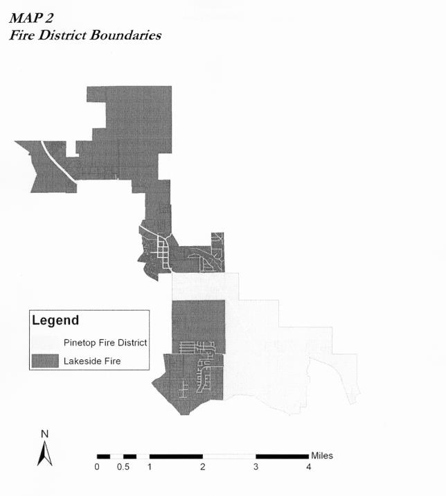
(Ord. 15-392 § 1 (part))