


Chapter 16.16
PLATTING PROCEDURES AND REQUIREMENTS
Sections:
16.16.010 Outline of procedures and requirements.
16.16.020 Stage 1 – Pre-application meeting.
16.16.030 Stage 2 – Preliminary plat application.
16.16.040 Stage 3 – Development Review Committee.
16.16.050 Stage 4 – Preliminary plat approval.
16.16.060 Stage 5 – Final plat and improvement plan approval.
16.16.070 Stage 6 – Recordation of plat.
16.16.090 Abandonment of recorded subdivision.
16.16.100 Condominium developments.
16.16.110 Minor land divisions – Lot splits.
16.16.010 Outline of procedures and requirements.
A. The preparation, submittal, review, and approval of all subdivision plats located inside the jurisdictional boundaries of the Town of Pinetop-Lakeside shall proceed through the following progressive stages.
1. Stage 1: Pre-application meeting.
2. Stage 2: Preliminary plat application.
3. Stage 3: Development Review Committee.
4. Stage 4: Preliminary plat approval.
5. Stage 5: Final plat and improvement plan approval.
6. Stage 6: Recordation of plat.
B. If a submittal is determined to be incomplete or inaccurate at or during any of the different stages of the process the developer shall be required to correct the inaccuracy and/or produce the omitted information.
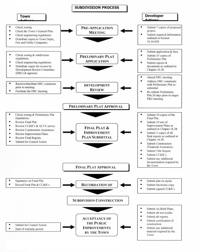
C. The following flow chart depicts the different stages of the process and the necessary actions to be taken with each stage.
(Ord. 15-392 § 1 (part))
16.16.020 Stage 1 – Pre-application meeting.
This stage affords the developer the opportunity to meet with the appropriate Town departments, prior to the expense of a preliminary plat preparation, to obtain advice, assistance, and a cursory review of the proposed subdivision. It also affords the Town the opportunity to give informal guidance at a time when potential points of conflict can be most easily resolved, subsequent relations improved, official action simplified, and undue expense and delay saved by the developer.
A. Actions by the Developer.
1. The developer shall schedule a mandatory pre-application meeting with the Community Development and Engineering Department staff. When scheduling the mandatory pre-application meeting, the developer shall submit seven (7) copies of a sketch plan for staff to review in preparation for the pre-application meeting.
2. The sketch plan shall be printed on twenty-four (24) by thirty-six (36) inch, blue line or black line. The sketch plan shall include at a minimum the following information:
a. Location map.
b. Scale drawing and north arrow.
c. Location of all public arterial and collector streets.
d. Acreage and land uses of all parcels.
e. Conceptual lot configuration.
f. Conceptual roadway layout and street design.
g. Table of land use data including: gross and net acres, percent of total acreage in each land use category, existing zoning, proposed zoning, and tentative lot sizes.
h. Preliminary topography with two (2) foot contour intervals along with the FEMA information overlaid.
i. Surrounding and adjacent land uses.
3. Tentative proposals regarding water supply, sewage disposal, and surface drainage.
B. Actions by the Town.
1. Depending on the scope of the proposed development, the Town may distribute the seven (7) sketch plans to the following departments and/or agencies:
a. Pinetop-Lakeside Community Development Department.
b. Pinetop-Lakeside Engineering Department.
c. Pinetop-Lakeside Recreation Department.
d. Fire District.
e. U.S. Forest Service staff.
2. The Town shall discuss the proposal with the developer in general terms and provide advice on procedural steps, design and improvement standards, and general platting requirements.
3. Check the existing zoning of the proposed development and advise the developer if a zoning change or a general plan amendment is necessary or desirable. Review the proposal and its relationship to adjacent land uses and the general plan’s goals and objectives. Determine the amount and type of parks, unbuilt common area or other public facility needs for the area as determined by the general plan and Recreation Department plans and/or policies; to then determine what space needs shall be reserved or set aside with any special requirements for such site. Review for compliance with these Subdivision Ordinance regulations and any other applicable regulations.
4. Determine if the size, complexity, or the land use mix of the proposed development would warrant the preparation of a planned unit development (PUD). If a PUD is required such shall be processed prior to subsequent consideration of a preliminary plat.
5. If a general plan amendment is required that amendment must be obtained prior to additional processing of the application.
6. Inspect the site and review the relationship of the property to major streets, utility systems and adjacent land uses and determine any unusual problems such as utilities, drainage or flooding. Determine street width and right-of-way requirements, intersection relationships and other traffic control related characteristics. Identify possible off-site public improvements and dedications. Review the wastewater disposal system.
7. Help the developer determine the providers of water, sewer, electricity, natural gas, telephone and cable.
8. Provide the applicant with the necessary Town application forms, review the submittal requirements, and discuss tentative timetables for the project. (Ord. 22-453 § 1; Res. 22-1640 (Exh. A); Ord. 15-392 § 1 (part))
16.16.030 Stage 2 – Preliminary plat application.
The preliminary plat stage of land and airspace subdivision includes detailed planning, submittal, review, and approval of the preliminary plat. This stage is intended to resolve most all of the major issues pertinent to the land development according to the Town’s policies, standards, codes, and requirements. To avoid delay in processing the application, the developer shall provide the Town with all information essential, as determined by the Town, regarding the character and general acceptability of the proposed development.
A. Submittal Requirements.
The following information is required as part of the preliminary plat submittal and shall be shown graphically, by note on plans, or by letter, and may comprise several sheets showing various elements of required data. All mapped data for the same plat shall be drawn at the same standard engineering scale which shall not be less than one (1) inch equals one hundred (100) feet, adjusted to produce an overall drawing measuring twenty-four (24) by thirty-six (36) inches and in conformance with requirements contained in this Ordinance and by the Town Engineer and other reviewing departments and agencies.
1. Fifteen (15) copies/sets of the proposed preliminary plat and other required supporting data prepared in accordance with requirements set forth in this Chapter shall be filed with the Administrator. Submission shall include fees as required in Chapter 16.08. Copies of the preliminary plat shall be reproduced in the form of blue line or black line prints on a white background. Scheduling of the case for the Development Review Committee (DRC) meeting shall be dependent upon adequacy of data presented and completion of processing.
2. If the proposed preliminary plat is within an approved PUD, fifteen (15) copies of the approved PUD site plan shall also be submitted as supporting documentation and project phasing shall be indicated.
3. All subdivision submittals shall provide identification and descriptive data, existing conditions data, proposed conditions data, proposed utility methods, and environmental assessment report information by graphic representation or note as further outlined in the following subsections. The submittal shall be checked by the Town for completeness and assigned a case number; if incomplete as to those requirements set forth in this section, the submittal shall be rejected and the developer notified within fifteen (15) days of the date the application was received.
4. If the developer is planning to plat the proposed development in phases it must be so indicated on their preliminary plat when submitted for development review. If the developer later decides to phase the development, it will be necessary to re-submit for a second review.
5. Submit three (3) copies of the preliminary drainage report in a separate bound folder. See Section 16.28.030(E)(1) for more specific details.
6. Submit three (3) copies of the preliminary traffic impact analysis in a separate bound folder. See Section 16.28.030(E)(4) for more specific details.
7. Submit three (3) copies of the preliminary geotechnical report in a separate bound folder. See Section 16.28.030(E)(3) for more specific details.
8. Submit a lot statistical table.
9. Submit fifteen (15) copies of the preliminary landscape plan for all off-site, unbuilt common area, trails, and retention area landscaping. See Section 16.28.030(C)(1) for more specific details.
10. Submit fifteen (15) copies of the preliminary fuel modification plan in compliance with Chapter 17.96, Forest Health and Fire Protection. See Section 16.28.030(D) for more specific details.
11. Submit subdivision fencing detail, if applicable, depicting the type of fencing being proposed; including elevations and general locations.
12. Submit a conceptual "Residential Design Guidelines" which both narratively and graphically describes the character, site planning, architecture (if a tract homebuilder is building the subdivision) and landscaping that can be expected from the development.
13. Submit documentation that a site records check, for potential cultural resources, has been conducted in conjunction with the State Historic Preservation Office.
14. Submit fifteen (15) copies of a slope analysis as required by Section 16.20.050 if the subdivision is a Mountainside Development. Include slope analysis of existing topography, slope analysis of the proposed development areas and building pad sites, and delineation of unbuilt common areas.
B. Identification and Descriptive Data.
1. The proposed name of the subdivision shall be clearly indicated and include the location by section, township and range with reference by dimension and bearing to two (2) section or quarter (1/4) section corners. Basis of bearings must be stated on the plat.
2. Name, address, phone number, and seal of the registered land surveyor preparing the preliminary plat and the registered civil engineer preparing the improvements.
3. Name, address, e-mail, and phone number of developer.
4. Scale, north point (pointing up or to the right), and date of preparation including any subsequent revision dates.
5. Location map which shall show the relationship of the proposed subdivision to arterial and collector streets.
6. A surveyed boundary, including distances, lengths and bearings and the total area of the proposed subdivision.
C. Existing Conditions Data.
1. Topography by contours and spot elevations on Town datum and related to USGS survey datum shown on the same map as the proposed subdivision layout. Contour intervals shall be at two (2) feet and shall be shown extending a minimum of fifty (50) feet from the external boundaries of the proposed development so to adequately reflect the character and drainage of the land.
2. Location of fences, existing structures, wells, canals, irrigation materials, private ditches (open or covered), washes, stock ponds or other water features and characteristics that could have a bearing on the review.
3. Location, direction of flow, and extent of areas subject to flooding or storm runoff must be defined (FEMA data and any federal Clean Water Act, Section 404 designation), whether such inundation is frequent, periodic, or occasional.
4. Location, widths and type of any and all easements (public and private) of public record of all private and public streets that may exist around the perimeter of the site, through or across it. Show any permanent structures that are to remain, including water wells and public or private utility lines within, adjacent to, or extending from, the proposed development.
5. Show all driveways, streets and median openings within three hundred twenty-five (325) feet of any proposed driveway or street intersection on the opposite side of the perimeter streets.
6. Name, book, and page numbers of any recorded subdivision adjacent to or having common boundaries with the proposed development.
7. The existing base zone of the subject and adjacent parcel(s), the zoning case number, if any, and the case number of the approved PUD of which the proposed development is a part of, if applicable.
8. The gross acreage of the subject parcel(s). Do not include previously dedicated rights-of-way in this figure.
9. Boundaries and dimensions of the parcel(s) to be subdivided shall be fully dimensioned.
10. Engineers’ calculations for each tributary area of the runoff for ten (10) year, fifty (50) year and one hundred (100) year frequency storms. The values to be indicated along the boundary of the parcel for all points of drainage entering and exiting the property.
D. Proposed Conditions Data.
1. Street layout, including design cross section, preliminary curve data, curve lengths, proposed street names based on existing projected alignments wherever possible, and pedestrian connections to adjoining developments.
2. Typical lot dimensions (scaled), dimensions of all corner lots, lots on curvilinear sections of streets, and all lots where the number of sides exceeds four (4). Each lot shall be numbered individually and the total number of lots or dwelling units provided. Where plats will consist of a number of units/phases, utilizing the same subdivision name, the lot numbering shall be consecutive through the total number of lots or units.
3. Designation of all land to be dedicated or reserved for unbuilt common area, parks, schools, well sites, or other public or private use with use indicated.
4. If multiple uses are planned (multiple residential, commercial, industrial, or office) such areas shall be clearly designated together with existing zoning classification and status of zoning change, if any.
5. Show minimum setback lines. Where there are lots with more than four (4) sides or whose shape may be considered atypical, show all setbacks.
6. Proposed storm water disposal system, preliminary calculations, and layout of proposed drainage system. The direction of proposed street drainage to be indicated by arrows on the plat, the one hundred (100) year flood plain delineation and a proposal to provide for the detention of storm water generated on the property. Detention of storm water to comply with the drainage policy of the Town of Pinetop-Lakeside and the design standards of this Ordinance.
7. Compliance with rules as may be established by the State Department of Environmental Quality and/or State Department of Water Resources relating to the provision of domestic water supply and sanitary sewage disposal.
E. Proposed Utility Methods.
1. Sewage Disposal. A statement as to the method for sanitary sewage disposal for the development shall appear on the preliminary plat. The plat shall also show the preliminary sewer layout indicating line sizes, manholes, direction of flow, and cleanout locations. If the Pinetop-Lakeside Sanitary District will not provide sanitary sewer services for the development, a letter from the Sanitary District approving the use of an alternate system is required.
2. Water Supply. A statement as to the water supply and the water provider for the development shall appear on the preliminary plat. The preliminary layout of the water system shall be shown, indicating fire hydrants, valves, meter vaults, water line sizes and locations.
3. Electric Supply. A statement as to the electric supply for the development shall appear on the preliminary plat. Any necessary easements shall be shown on the preliminary plat.
4. Gas Supply. A statement as to the gas supply for the development shall appear on the preliminary plat. Any necessary easements shall be shown on the preliminary plat.
5. Telephone Service. A statement as to the telephone service for the development shall appear on the preliminary plat. Any necessary easements shall be shown on the preliminary plat.
6. Garbage Service. A statement as to the garbage service for the development shall appear on the preliminary plat.
7. Cable Television. If applicable, a statement as to the cable television service for the development shall appear on the preliminary plat.
F. Environmental Assessment Data. The purpose of the environmental site assessment is to provide a written and graphic analysis of the environmental characteristics of the site so that the Town of Pinetop-Lakeside can evaluate the future use of the site. The Phase 1 environmental report will identify any hazardous waste site within the proposed subdivision. Environmental site assessments are required for all preliminary plat applications. This study shall include written reports and maps that provide the information outlined below:
1. The Phase 1 environmental report shall:
a. Describe the site and identify uses or activities which might indicate the presence of disposed hazardous substances; and
b. Be prepared through the review of readily available information, including but not limited to engineering, regulatory, and historical records of the site, and through the interviewing of current and past owners of the site, tenants and neighbors; and
c. Be prepared to thoroughly review the regional geology and hydrology of the site and the surrounding area, available records of groundwater contamination up and down gradient from the site, obtainable reports of compliance violations and/or containment discharges in the site’s vicinity, and the proximity of the site to known environmental conditions or problems within approximately one (1) mile of the site; and
d. Reference the data, records and source of information.
2. The applicant’s consultant shall:
a. Personally observe the site surface closely for evidence of potential contamination such as soil stabilizing, discarded chemical containers, vegetative distress; and
b. Interview the tenants on/or adjacent to the site with respect to their use of hazardous substances on the site; and
c. Investigate the registration status of any existing underground storage tanks or drywells on or adjacent to the site; and
d. Identify any adverse environmental impacts. (Ord. 15-392 § 1 (part))
16.16.040 Stage 3 – Development Review Committee.
In order for a preliminary plat to be scheduled for a particular Development Review Committee (DRC) meeting, a complete preliminary plat application must be received and accepted by the Town.
A. Upon receipt of a preliminary plat application the Town shall determine if the application is a complete submittal. If complete, the Town shall forward copies of the preliminary plat to the following agencies and entities along with those previously listed in Section 16.16.020. These reviewing agencies shall transmit their written comments and recommendations to the Town.
1. U.S. Postmaster.
2. Water company serving the proposed development.
3. Pinetop-Lakeside Sanitary District.
4. Lakeside Irrigation District.
5. Blue Ridge Unified School District.
6. Navopache Electric Cooperative, Inc.
7. Cable One, Inc.
8. Frontier-Citizens Communications.
9. UniSource Energy Services.
B. The Town shall host a Development Review Committee (DRC) meeting where the applicant is provided an opportunity to meet with the representatives from all applicable utilities and other interested governmental agencies to receive comments regarding the preliminary plat application. At this meeting the applicant may also receive written comments from the Town, detailing the extent to which the plans are required to be revised in order for the Town to schedule the preliminary plat for consideration by the Planning and Zoning Commission. Extensive revisions caused by the comments received at the DRC meeting or by voluntary action of the applicant, may require additional DRC meetings. Additionally, circumstances may exist where the project may experience delay due to the applicant’s timeline in addressing agency comments. (Ord. 15-392 § 1 (part))
16.16.050 Stage 4 – Preliminary plat approval.
The preliminary plat approval stage involves the re-submission of the preliminary plat to address the DRC comments. Included in this stage is the review of the resubmitted plans, reports, and required studies and acceptance of the preliminary plat. The developer shall provide the Town with all information essential to determine the character and general acceptability of the proposed development.
A. Preliminary Plat Resubmittal.
1. The applicant shall resubmit fifteen (15) full-sized copies/sets of the preliminary plat and one (1) eight and one-half (8-1/2) by eleven (11) inch photo mechanical transfer (PMT) of each sheet/exhibit and all other required or requested supporting data to the Town. Preliminary plats that correctly contain all of the information requested or required by the DRC, as determined by the Town, shall be scheduled for a Planning and Zoning Commission hearing. Incomplete or incorrect re-submittals could cause delays in a preliminary plat being presented to the Planning and Zoning Commission. Scheduling of the case for a Commission hearing shall be determined by the Director and shall be dependent upon adequacy of data presented, completion of processing, and other legalities that may be required if the subdivision involves rezoning, PUD, or other land use exceptions.
2. Prior to the Commission hearing for a preliminary plat or PUD, the applicant is strongly encouraged to conduct a neighborhood meeting. The purpose of the meeting would be to provide information to the adjacent property owners and citizens. The applicant should notify all landowners adjoining or adjacent to the boundaries of the proposed development and the Town of Pinetop-Lakeside by first class mail no less than thirty (30) days prior to the scheduled Commission meeting. The applicant should submit documentation of the attendees and minutes of the meeting(s) to the Director. All meeting(s) must be held within the Town of Pinetop-Lakeside corporate limits.
3. An applicant has ninety (90) days from the date of the DRC meeting, or ninety (90) days from the date of receipt of later redlines, in which to resubmit said plans. Failure to resubmit plans which address all of the DRC comments, or subsequent redline comments, within ninety (90) days of the DRC meeting or ninety (90) days from the receipt of later redlines shall cause the application to be null and void and fees will not be refunded.
4. An applicant shall be required to submit a new preliminary plat application, including fees and another review of the subdivision by the DRC if the resubmittal is not in substantial conformance to the original application. Substantial nonconformance is considered to be, but not limited to, the following:
a. An increase in the number of lots or units.
b. A change in the size or configuration of the development parcel.
B. Preliminary Plat Review.
1. Zoning. The subdivision shall be designed to meet the specific requirements for the zoning district within which it is located. However, in the event that rezoning is necessary for the preliminary plat to conform with the Zoning District regulations, or if a PUD approval is sought, said action shall be initiated concurrently with the preliminary plat by the property owner or his authorized agent. In any event, any such zoning amendment required in relation to the preliminary plat shall have been adopted prior to a preliminary plat approval.
2. Planning. The subdivision shall be designed to comply with the design principles of this Ordinance and the goals and objectives of the Pinetop-Lakeside general plan. In the event that an amendment to the general plan is necessary for the preliminary plat to conform with the specific land use, circulation, or unbuilt common area elements, said amendment(s) required in relation to the preliminary plat shall have been adopted prior to a preliminary plat approval.
3. Utilities and Services. As a prerequisite of preliminary plat approval by the Town, the developer shall have reviewed tentative concepts with the County Health Department, the State Department of Environmental Quality, the State Department of Water Resources, the Town Engineer, Community Development, the Parks and Recreation Department, the U.S. Forest Service, the Pinetop-Lakeside Sanitary District and the Fire District servicing the development. The developer shall have an "intent to serve letter" from the private water company servicing the development, the Pinetop-Lakeside Sanitary District, and the electric, gas, telephone and cable television companies servicing the development and general approval of the preliminary design to be used.
C. Preliminary Plat Approval.
1. When all requirements of this Ordinance have been satisfied the case will be scheduled for a Commission preview meeting in which no action is taken by the Commission but rather the public is simply informed about the project and allowed to ask questions and voice concerns.
2. After the Commission preview meeting the preliminary plat will be scheduled for a Commission hearing. The Community Development Department report shall be submitted for Commission review and action.
3. The Commission shall consider the preliminary plat, DRC comments, and the Community Development Department report and recommendations. If satisfied that all objectives and requirements of this Ordinance have been met, the Commission may approve the preliminary plat and make a notation of the Commission’s approval on the copy of the preliminary plat retained in the office of the Director.
4. If the plat is generally acceptable, but requires minor revisions, the Commission may conditionally approve the preliminary plat and the required revisions noted in the minutes of the meeting. At the direction of the Commission, the Director may approve the preliminary plat when it has been satisfactorily revised in accordance with the stated conditions.
5. If the Commission finds that all of the objectives and requirements of this Ordinance have not been met, the Commission may continue the preliminary plat pending revisions, or deny the preliminary plat. Resubmittals due to revisions, for the same parcel or any part thereof, shall follow the aforementioned procedure.
D. Significance of Preliminary Approval.
Preliminary plat approval constitutes authorization for the developer to proceed with preparation of the final plat and the improvement plans and specifications for public improvements. Preliminary plat approval does not authorize the developer to cut roads or other easements, begin site preparation and grading, or any similar such work unless authorized in writing by the Town. Preliminary approval is based on the following terms:
1. Subject to the basic approval. The basic conditions under which preliminary approval of the preliminary plat is granted will not be substantially changed prior to the expiration date.
2. One (1) year approval. Approval of the preliminary plat is valid for a period of twelve (12) months from the date of Commission approval. An extension of the preliminary plat approval may be granted for an additional six (6) months upon reapplication and review by the Commission.
3. No authority to record. Preliminary approval, in itself, does not assure final acceptance of streets for dedication nor continuation of existing zoning requirements for the development or its environs nor constitute authorization to record the plat. (Ord. 15-392 § 1 (part))
16.16.060 Stage 5 – Final plat and improvement plan approval.
This stage includes the final design of the subdivision, engineering of public improvements, and submittal by the developer of the final plat, final reports, and plans for all of the required subdivision improvements, to the Town, the state and county departments, and the utility companies for approval; including the submittal of the final plat for review and action by the Town Council.
A. Submittal Requirements.
1. Final Plat Preparation.
a. Presentation. The final plat shall be presented in accordance with requirements set forth in this section, and shall substantially conform to the approved preliminary plat and applicable zoning stipulations.
b. Zoning. The final plat shall meet all requirements of the zoning district in which it is located; and necessary zoning amendments shall have been adopted by the Town Council prior to filing the final plat with the Administrator.
c. Pre-Final Review. The developer shall file fifteen (15) full size (twenty-four (24) by thirty-six (36) inch) blue or black line copies of the final plat with the Town who in turn will distribute copies to the various reviewing agencies. The reviewing agencies shall make known their recommendations in writing. The Town shall review the plat for substantial conformity to the approved preliminary plat.
d. Final Plat Submission. The developer shall file with the Town three (3) full size mylars, three (3) full size blue or black line copies, one (1) eight and one-half (8-1/2) by eleven (11) inch PMT and ten (10) copies thereof, of the final plat. The final plat shall be drawn in black ink on polyester mylar, measuring exactly twenty-four (24) by thirty-six (36) inches with a left hand margin of two (2) inches, and be drawn to an accurate engineering scale from an accurate survey. The applicant shall also submit an electronic copy of the final plat in a file format required by the Town of Pinetop-Lakeside.
2. Improvement Plans. Improvement plans shall be submitted in accordance with the procedures and standards established in Chapter 16.28. Ten (10) complete sets of improvement plans shall be submitted to the Town. If the submittal is complete, the Town shall distribute sets of the plans to the appropriate reviewing departments, agencies and utility companies who shall make known their recommendations in writing.
3. Covenants, Conditions and Restrictions (Deed Restrictions). The subdivision deed restrictions shall be submitted to the Town for review as part of the final plat and improvement plan submittal package.
4. Title Report. The developer shall, at the time of filing the application(s) for the final plat and improvement plans, submit an American Land Title Association (ALTA) title report, not more than thirty (30) days old, certifying that the applicant has title, acceptable to the Town Attorney, for all of the land being subdivided.
5. Filing Fees. The developer shall, at the time of filing the application(s) for the final plat and improvement plans, pay the Town the final plat application fee, improvement plan review fees, and the recordation fee, in accordance with Chapter 16.08, which are established by the Town Council.
B. Identification Data. The following identification data shall be required as a part of the final plat submittal.
1. A title, which includes the name of the subdivision and its location by number of section, township, range, and county.
2. Name, address and seal of the Arizona-registered land surveyor preparing the final plat.
3. Scale, north arrow, and date of plat preparation.
4. The name, address and telephone number of the property owner.
C. Survey Data. The following survey data shall be required as a part of the final plat submittal.
1. The corners of the plat shall be located on the monument lines of abutting streets; boundaries of the parcel(s) to be subdivided fully balanced and closed, showing all bearings and distances, determined by an accurate survey in the field. The surveyor of record shall also provide a copy of the computer closure, properly stamped and signed showing registration number. All dimensions shall be expressed in feet and decimals thereof.
2. Any excepted parcel(s) within or surrounded by the plat boundaries shall be noted as "Not a Part of This Subdivision" and show all bearings and distances of the excepted parcel as determined by an accurate survey in the field. All dimensions shall be expressed in feet and decimals thereof.
3. Location and description of cardinal points to which all dimensions, angles, bearings and similar data on the plat shall be referenced. Each of two (2) separate corners of the subdivision traverse shall be tied by course and distance to separate section corners or quarter-section corners. The certifying land surveyor shall submit subdivision boundary and lot closure and area calculations to the Town.
4. Location of all physical encroachments upon the boundaries of the tract.
5. Total subdivision gross acres.
6. Total number of lots and parcels, and the size, in square feet, of each lot or parcel. The size of lots or parcels greater than ten (10) acres in size may be expressed in acres.
D. Descriptive Data. The following descriptive data shall be required as part of the final plat submittal.
1. Names, centerlines, right-of-way lines, courses, length and width of all public streets, alleys, pedestrian ways, and utility easements; radii, point of tangency, curve lengths, and central angles of all curvilinear streets, and alleys; radii of all rounded street line intersections.
2. All drainage easements shall be shown on the plat. No structure will be allowed in the easements that will obstruct drainage. The rights-of-way of all major drainage ways shall be dedicated drainage easements or right-of-way as determined by the Town Engineer.
3. All lots shall be numbered by consecutive numbers throughout the plat. All "tracts" and "parcels" shall be designated, lettered, or named and clearly dimensioned; parcels which are not part of the subdivision shall be so designated. Ownership and maintenance responsibility for open space and unbuilt common areas shall be indicated on the plat.
4. Location, dimensions, bearings, radii, arcs, and central angles of all sites to be dedicated to the public with the use clearly indicated.
5. Location of all adjoining subdivisions with name, date, book, and page number of recordation noted, or if unrecorded, so noted.
6. Any proposed private deed restrictions to be imposed upon the plat or any part or parts thereof pertaining to the intended use of the land, and to be recognized by the Town, shall be noted on the plat (see subsection F of this section for details).
7. All existing private easements within, on, or over the plat shall be indicated, dimensioned, and noted as to their use. The location and widths of all easements for right-of-way provided for public services, utilities, or drainage, and any limitations of the easements.
a. The following notation shall be placed on all final plats which provide drainage easements: "No structure of any kind shall be constructed or any inappropriate vegetation be planted nor be allowed to grow within, on or over the drainage easement, which would obstruct or divert the flow of storm water. The Town may, if it so desires, construct and/or maintain drainage facilities on or under the land of the easement".
E. Dedication and Acknowledgement.
1. Dedication. There shall be required as part of the final plat submittal a statement of dedication of all streets, alleys, drainage detention basins and drainage ways, pedestrian/bicycle ways, equestrian trails and easements, and other easements for public use, including sanitation, utility, fire and other emergency related vehicles, executed by the person or persons holding title of record, by persons holding titles as vendees under land contract, by the spouse(s) of said parties, lien holders and all other parties having an interest in the property. If lands dedicated are liened, the lien holder shall also sign the plat. Dedication shall include a written location by section, township and range of the tract. If the plat contains private streets, a public easement shall be reserved which shall include the right to install and maintain utilities in any approved private street, including refuse collection, fire and other emergency services.
2. Acknowledgment of Dedication. Execution of dedication shall be acknowledged and certified by a Notary Public.
F. Required Certification, Signatures, and Notes. Multiple notations are required to appear on a final plat. The notations that are standard on every final plat include, but are not limited to, the following:
1. Assurance statement, as follows:
Assurance Statement:
Assurance in the form of a ______________, issued from ___________________ in the amount of $______ has been deposited with the Town Engineer to guarantee construction of the required subdivision improvements.
2. Conveyance and dedication statements, as follows:
Conveyance and Dedication:
Know all men by these presents that (owner’s name), as owner, have subdivided (or re-subdivided) under the name of (name of subdivision), (add Section, Township and Range) of the Gila and Salt River Base and Meridian, Navajo County, Arizona as shown platted hereon, and hereby publishes this plat as and for the plat of said (subdivision name), and hereby declares that said plat sets forth the location and gives the dimensions of all lots, easements, tracts and streets constituting the same, and that each lot, tract and street shall be known by the number, letter and name given each respectively, and that (owner’s name), as owner, hereby dedicates to the public for use as such the streets and hereby grants to the public the drainage and public utility easements as shown on said plat. In witness (owner’s name), as owner, has hereunto caused its name to be signed and the same to be attested by the signature of (owner or designated signatory and title).
By: _________________________________________________________ Date: ________________
Owner’s Name and Title
3. Notary acknowledgment statement, as follows:
Notary Acknowledgment: State of Arizona )
County of Navajo )
On this, the ____________ day of _______________, (year), before me the undersigned (title) personally appeared _______(Name)_________ who acknowledges that he/she executed the foregoing instrument for the purposes contained therein.
In witness whereof I hereunto set my hand and official seal.
_______________________________ My Commission Expires
Notary Public ______________________
4. Provision for water service, as follows:
Water Provider:
The _______________________ Water Company has agreed to serve this subdivision.
By: ______________________________________________________
(Title)
5. Provision for sanitary sewer service, as follows:
Pinetop-Lakeside Sanitary District:
The Pinetop-Lakeside Sanitary District has/has not agreed to serve this subdivision, and has/has not agreed to allow the subdivision to use an alternate sewage disposal method.
By: ________________________________________
District Manager
6. Town approval signature blocks, as follows:
Town Council Approval:
Approved by the Town Council of Pinetop-Lakeside, Arizona, this ___________ day of ____________, _________ (year).
By: ____________________________________________________ Attest: _____________
Mayor Town Clerk
Town Department Approvals:
This plat was approved by the Town Engineer and the Director.
By: ____________________________________________________ Date: ______________________
Town Engineer
By: ____________________________________________________ Date: ______________________
Director
7. Surveyors certification, as follows:
Surveyors Certification:
This is to certify the survey and subdivision premises described and platted hereon were made under my direction, that the plat is correct and accurate, that the monuments shown hereon have been located or established as described and lot corners have been permanently set.
__________________________________
(Surveyor’s name and registration number) (Stamp)
(Surveyor’s address)
8. Covenants, conditions and restrictions (deed restriction) information, as follows:
Covenants, Codes and Restrictions for (name of subdivision) Pinetop-Lakeside, Arizona are recorded in (document recording number), Navajo County Records.
9. Typical notes, as follows:
Notes:
• benchmark information.
• basis of bearing information.
G. Final Plat Approval.
1. Upon approval of the improvement plans and final reports; letters from all involved utility companies approving the utility installation plans and confirming the availability of services; all required certifications from state and county agencies; and receipt of a request for Town Council action from the Town Engineer; the Town Clerk shall place the plat on the agenda of a Council meeting, whereupon the Town Council shall approve or deny the plat.
2. If the Town Council approves the plat, the Mayor shall sign the plat and the Town Clerk shall attest the Mayor’s signature.
3. When the certificate of approval by the Town Council has been transcribed on the plat, the Director shall retain the recording copies until the Town Engineer certifies that the subdivision has been staked; the improvement plans and final reports have been approved; a computer closure of the plat has been received; recording fees submitted; that the subdivision improvement construction assurances are in the form and amount to the satisfaction of the Town Engineer and the Town Attorney, along with the Engineer’s estimated cost of said improvements has been received; and that any drainage or other restrictive covenants have been signed, notarized and received from the developer.
4. Approval of the final plat is valid for a period of twelve (12) months from the date of Town Council approval. If the developer fails to provide the required material or perform the necessary work, as indicated in this section, within this twelve (12) month period, the final plat approval by council shall become null and void. Any further action on said plat, after the expiration of the approval, shall require a complete re-submittal of the plat. (Ord. 15-392 § 1 (part))
16.16.070 Stage 6 – Recordation of plat.
Upon receipt of the required material, documents, and fees, and performance of the necessary work as listed in Section 16.16.060, the Town shall then cause the final plat to be recorded in the Office of the County Recorder of Navajo County. (Ord. 15-392 § 1 (part))
16.16.080 Replats.
A. Any division of a lot in a recorded subdivision, or any change in lot lines in a recorded subdivision, shall be processed in accordance with Section 16.16.060, after a pre-application conference with Town staff as provided in Section 16.16.020.
B. Any replat involving the dedication of land for a public street or any off-site public improvements shall comply with all procedures set forth in this chapter.
C. If the abandonment of a street, alley or public utility easement or other recorded easement in a previously recorded subdivision is necessary, either a replat or a certificate of correction, as determined by the Director, shall be processed concurrently with the abandonment and recorded immediately subsequent to the recordation of the abandonment. (Ord. 15-392 § 1 (part))
16.16.090 Abandonment of recorded subdivision.
A. Pursuant to the provisions of A.R.S. § 28-7201 et seq., the abandonment of all or part of a recorded subdivision may be initiated by written petition to the Town Council. The petition shall be signed by all owners of real property in said subdivision requesting abandonment of all streets, alleys and easements within said subdivision and giving the legal description and recording information thereof.
B. Applications for the abandonment of a recorded subdivision are filed with the Director and referred for recommendation to the appropriate Town staff and utility companies. After Town Council approval of the abandonment of any streets, alleys and easements within the subdivision, and after Town Council approval of the abandonment resolution for the recorded subdivision, and after the abandonment resolutions are recorded with the County Recorder’s Office, the subdivision is removed from the official maps. (Ord. 15-392 § 1 (part))
16.16.100 Condominium developments.
A. The application requirements, processing and approval regulations contained within this Ordinance shall apply to all condominium developments.
B. All condominium subdivisions shall comply with the provisions of this Ordinance and the Zoning Ordinance for the Town of Pinetop-Lakeside, and the location of building shown on the plat and the manner in which the airspace is to be divided in conveying the condominium shall be clearly defined and shall not violate any provision of this Ordinance.
C. In order for the condominium subdivision application to be considered complete, the applicant shall provide to the Town any plans, specifications, and/or analysis needed to show that the proposed condominium subdivision is in compliance with this Ordinance and the Zoning Ordinance for the Town of Pinetop-Lakeside, including but not limited to grading plans, site plans, floor plans, elevations, and landscape plans. (Ord. 15-392 § 1 (part))
16.16.110 Minor land divisions – Lot splits.
A. The provisions in this section shall apply to any minor land division of improved or unimproved property, including a lot, parcel, tract, or combination thereof, for the purpose of financing, sale or lease, whether immediate or future, if one of the following conditions exists:
1. The division of land whose area is two and one-half (2-1/2) acres or less and is being divided into two (2) or three (3) tracts or parcels of land for the purpose of sale or lease.
2. The area of the property to be divided is greater than two and one-half (2-1/2) acres and requires the creation of a public or private street or easement to provide legal access to one (1) or more additional lots.
3. Any original lot, as defined by this ordinance, in a residential zone, not a part of a recorded subdivision plat, to be divided into two (2) or three (3) lots.
4. The division of land into more than two (2) parts, and when the boundaries of such property have been fixed by a recorded plat.
B. A minor land division does not include the adjustment of a property line, where land taken from one (1) lot is added to an adjacent lot, provided the proposed adjustment does not create a substandard lot. A certificate of correction shall be required if the property line adjustment is for lots within a recorded subdivision plat.
C. An application for a minor land division shall be submitted to the Director prior to any deeds related to a minor land division with the Navajo County Recorder’s office. The Town may approve minor land divisions administratively.
D. Except where expressly modified or permitted by staff all minor land divisions shall be in general conformity with the design standards and principles outlined for subdivisions in Chapter 16.24. All lots created by a minor land division shall be designed to conform to existing zoning and the general plan.
E. If dedicated and/or public improvements are required for minor land divisions, the applicant shall be responsible for the preparation of a complete set of improvement plans, prepared by an Arizona-registered civil engineer, satisfactory to the Town Engineer for the construction of the required improvements. The plans shall be prepared in conjunction with the minor land division map and the requirements outlined in Chapter 16.28.
F. The minor land division map shall not be recorded, nor shall any improvement work commence, until the Town Engineer has approved the improvement plans.
G. No minor land division, which creates a substandard or nonconforming lot or structure, shall be approved except by Council action.
H. If any improvements are required for the minor land division pursuant to regulations contained herein, no building permit for any lot created will be issued until such improvements are completed and the work accepted by the Town Engineer unless the developer provides construction assurance in a form acceptable to the Town Attorney as outlined in Chapter 16.28. (Ord. 15-392 § 1 (part))