


Chapter 18.61
HD HILLSIDE DEVELOPMENT OVERLAY ZONE
Sections:
18.61.020 Scope and exceptions.
18.61.050 Protected peaks and ridges.
18.61.070 Slope density requirements.
18.61.080 Development standards.
18.61.090 Platting and development plan requirements – Review – Compliance.
18.61.100 Variances – Special use permits.
18.61.010 Purpose.
The purpose of this chapter is to establish standards for hillside areas which conserve and promote the public health, safety, convenience and general welfare by:
A. Conserving the unique natural resources of hillside areas;
B. Minimizing water runoff and soil erosion problems incurred in development alteration of the terrain;
C. Providing safe and convenient access to hillside development;
D. Ensuring the efficient expenditure of public funds; and
E. Maintaining the character, identity, and image of the town of Sahuarita. [Ord. 2011-048 § 1; Ord. 1995-06 § 2.]
18.61.020 Scope and exceptions.
A. The overlay zone shall apply to any land parcel with an average cross slope of 15 percent or greater, or to land parcels with any slopes of 15 percent or greater.
B. Fractions of numbers shall be rounded off to the nearest whole number. When 0.5 or higher is computed, the number shall be rounded off to the next highest whole number.
C. The provisions of STC 18.61.070(A) shall not apply to land parcels recorded in the county recorder’s office prior to July 1, 1976. If land parcels are divided or used for multifamily development after that date, all appropriate provisions of this chapter shall apply.
D. The provisions of this chapter shall not apply to construction done pursuant to a building permit issued or recorded subdivision plat filed prior to February 5, 1986, if granted a hardship variance by the town council through the public hearing process. [Ord. 2011-048 § 1; Ord. 1995-06 § 2.]
18.61.030 Definitions.
A. Certain terms used in this chapter shall be defined for purposes of this chapter only, as follows:
“Average cross slope” means a method of determining the natural cross slope of a project site by using the following equation:
|
I X L X .0023 |
where: |
|
A |
|
I |
= |
Contour interval in feet; |
|
L |
= |
Combined length in feet of all contour lines measured on the project site, not to include contours in natural areas meeting the requirements of STC 18.61.060; |
|
.0023 |
= |
Conversion of square feet into acres X 100; |
|
A |
= |
Project site area in acres. |
“Building envelope” means the area to be occupied by any structure and associated development.
“Building site slope” means the average natural slope of the area designated as the building envelope measured at right angles to the natural contours along a line passing through the center of the building envelope: such line shall terminate at the opposite edges of the proposed building, or at the opposite edges of the proposed cut or fill, whichever distance is greater. Illustration: STC 18.61.110, Figure 18.61-1.
“Development” means any alteration of the natural or existing configuration of the earth’s surface or vegetative cover creating commercial, industrial, residential and accessory facilities including any and all utility services and circulation areas, such as streets, private roads, parking areas or driveways. An alteration of or any addition to a structure or circulation area which existed prior to July 1, 1976, and does not exceed either 1,000 square feet or 25 percent of the area covered by the existing structure, whichever is greater, shall not be considered “development.”
“Divide” means to separate into two or more land parcels.
“Enclosed area of dwelling unit” means the dwelling unit and all attached roofed structures, including carports and patio ramadas.
“Exposed slope” means all the face of a cut or fill, from the toe to the top, whether the surface is retaining walls, rip-rap, natural vegetation or other materials.
“Hillside building height” means the vertical distance from the lowest finish floor elevation of the building to the highest elevation point of the building or roof.
“Land parcel” means an area of land with boundaries recorded in the Pima County recorder’s office.
“Natural area” means a land area, unimproved and not occupied by any structures or manmade elements, set aside for the conservation of permanent, undisturbed open space.
“Peak point” means the single highest elevation spot of a peak.
“Project site” means an area consisting of one or more land parcels that is planned, reviewed and developed as a unified project, including designated natural areas.
“Ridge line” means a ground line connecting the series of highest elevational points of a ridge, running center and parallel to the long axis of the ridge.
“Slope plan” means a plan for development, clearly depicting all proposed grading including the location, extent and treatment of all exposed slopes. [Ord. 2011-048 § 1; Ord. 1995-06 § 2.]
18.61.040 Prohibited uses.
No NC, B-1, B-2, MX, CPI, I-1, or I-2 Zone shall be permitted on land parcels having average cross slopes of 15 percent or greater, or on any building envelope with a slope of 15 percent or greater. [Ord. 2015-105 § 1; Ord. 2011-048 § 1; Ord. 1995-06 § 2.]
18.61.050 Protected peaks and ridges.
A. There shall be no development within a horizontal radius (map distance) of 150 feet from a protected peak point or 150 feet from a protected ridge line. Illustration: STC 18.61.110, Figure 18.61-2.
B. When development is proposed within 500 feet of a protected peak or ridge, the developer shall submit to the department of transportation and flood control district (DTFCD) a topographic map (scale no smaller than one inch equals 100 feet with 10-foot contour intervals) delineating the protected peak or ridge, the peak point or ridge line and elevation, and the resulting area protected from development. Prior to any other plan review or permit issuance, this map shall be submitted to the DTFCD and, if DTFCD finds that it is accurate and in conformance with the requirements of this chapter, the map shall be approved and stamped by the DTFCD. This requirement shall also apply when a road or development is proposed within a protected area, subject to the granting of a variance or special use permit in accordance with STC 18.61.100. [Ord. 2011-048 § 1; Ord. 1995-06 § 2.]
18.61.060 Natural areas.
A. Scope. Natural areas set aside in any division of land shall not be included in the average cross slope analyses. The total acreage of the project site may be used for dwelling unit density calculations; provided, that all other applicable provisions of this section are met.
B. Development shall not be permitted within the legally described boundaries of a natural area. However, if utility or service trenches cannot reasonably be provided without crossing natural areas of the project site, such trenches may be permitted, provided they are revegetated in accordance with STC 18.61.080(D).
C. Natural areas shall be clearly delineated, in a surveyable manner, on all final plats and development plans (STC 18.61.090).
D. Natural areas shall be incorporated into the subdivision plat as either a portion of privately owned lots or as land parcels under the ownership of a homeowners’ association. Deed restrictions which prohibit development in natural areas shall accompany the plat. Where natural areas are located adjacent to major public parks, such areas may be deeded to the town of Sahuarita, subject to approval by the town parks and recreation division and by acceptance of the town council.
E. For project sites that will have more than one plat, a legal description and covenant restricting the use of the entire natural area shall be recorded by the developer in the county recorder’s office prior to the issuance of any building permit for the development of the project site.
F. Land parcels which include a natural area designation shall not be further divided. Recorded subdivisions within project sites that include relocated densities due to natural area designations shall not be further divided. [Ord. 2011-048 § 1; Ord. 1995-06 § 2.]
18.61.070 Slope density requirements.
A. On land parcels with average cross slopes of 15 percent or greater, average dwelling unit density shall not exceed that allowed by either the existing zoning on the parcel or the following table, whichever is more restrictive.
|
Average Cross Slope (%) |
Average Area per Dwelling Unit (acres) |
|---|---|
|
15 |
1.0 |
|
16 |
1.0 |
|
17 |
1.25 |
|
18 |
1.37 |
|
19 |
1.5 |
|
20 |
2.0 |
|
21 |
2.25 |
|
22 |
2.5 |
|
23 |
3.5 |
|
24 |
4.5 |
|
25 |
6.0 |
|
26 |
7.0 |
|
27 |
8.6 |
|
28 |
10.4 |
|
29 |
12.8 |
|
30 |
16.0 |
|
31 |
18.0 |
|
32 |
23.5 |
|
33 and greater |
36.0 |
B. The provisions of this section shall not apply when the cluster option is used on land parcels with average cross slopes of less than 20 percent. [Ord. 2011-048 § 1; Ord. 1995-06 § 2.]
18.61.080 Development standards.
A. Scope. This section shall apply to that portion of any development which occurs on slopes of 15 percent or greater.
B. Site Grading Requirements.
1. Scope. The total area of all grading (other than the enclosed area of dwelling unit) for driveways, parking areas, yards, swimming pools, walls, and accessory structures shall conform with the following requirements (See Table 18.61.080).
2. A building site slope analysis and a slope plan sealed by a civil engineer or land surveyor shall be submitted to the town engineer for review and approval of conformance with this chapter prior to any clearing, grading or the issuance of a building permit or grading permit (when required).
3. All grading shall be performed in accordance with STC Title 16.
C. Cut and Fill Requirements.
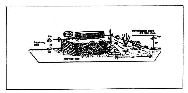
1. The vertical distance of exposed slopes shall not exceed 15 feet. Illustration: STC 18.61.110, Figure 18.61-3.
2. No cut or fill shall encroach upon any floodplain, except as provided for in the Floodplain Management Ordinance No. 1985-FCI or any adjacent properties except by the mutual written consent of all parties affected. Such consent is to be filed with the DTFCD.
3. Cut or fill material in excess of that approved for use shall not be disposed of over the sides of hills or ridges.
D. Site Restoration Requirements.
1. The restoration of a site shall be in accordance with Section 005-1 of the grading design manual (refer to STC Title 16, Grading Standards).
2. All slope treatment for local and minor collector streets shall be completed prior to final acceptance of streets and drainage improvements by the town, and prior to the release of assurances for the development.
3. All slope treatment for lots shall be completed prior to the final inspection of single-family residences or the issuance of a certificate of occupancy.
E. Color Requirements. All exposed exterior walls of dwelling units, retaining walls, and accessory structures shall be earthtone in color and shall blend in with the natural setting. White shall not be permitted.
|
Development Type |
Zone/Lot Size per Dwelling Unit |
Maximum Grading |
|---|---|---|
|
Cluster-attached |
R-1, R-2 |
50% of the project site remaining after exclusion of natural areas |
|
Single detached dwelling units |
20,000 sq. ft. or less |
50% of the project site remaining after exclusion of natural areas |
|
Single detached dwelling units |
Over 20,000 sq. ft. to 1 acre |
50% of first 20,000 sq. ft., or 30% of lot, whichever is greater |
|
Single detached dwelling units |
Over 1 acre to less than 4 acres |
30% of first acre, or 10% of lot, whichever is greater |
|
Single detached dwelling units |
4 acres to less than 15 acres |
10% of first 4 acres, or 7% of lot, whichever is greater |
|
Single detached dwelling units |
15 acres to less than 36 acres |
7% of first 15 acres, or 5% of lot, whichever is greater |
|
Single detached dwelling units |
36 acres and over |
5% of first 36 acres, or 3% of lot, whichever is greater |
|
Multiple dwellings/business offices/existing commercial and industrial |
|
80% of the project site remaining after exclusion of natural areas |
[Ord. 2011-048 § 1; Ord. 1995-06 § 2.]
18.61.090 Platting and development plan requirements – Review – Compliance.
A. Requirements.
1. In addition to the requirements of Chapters 18.69 (Subdivision Standards) and 18.71 (Development Plan Standards) STC, tentative plats and development plans submitted for town review shall include:
a. A topographic map of the existing terrain utilizing a scale no smaller than one inch equals 100 feet, with contour intervals no greater than:
(1) Two-foot intervals for slopes of 20 percent or less,
(2) Five-foot intervals for slopes over 20 percent, but less than 35 percent,
(3) Ten-foot intervals for slopes of 35 percent and greater;
b. The average cross slope of the project site analysis shall be sealed by a civil engineer or land surveyor registered in the state of Arizona;
c. A building site slope analysis and a slope plan, similarly sealed;
d. The location of all local and minor collector streets.
2. For project sites with an average cross slope of less than 15 percent, but with portions that are 15 percent or greater, the following shall be noted on the tentative plat, final plat and development plan: “Lots (list which lots) may be subject to the Hillside Development Overlay Zone as determined by review of a building site slope analysis by the County department of transportation and flood control, and any development to be placed thereon shall be shown to conform to the requirements of the Hillside Development Overlay Zone prior to the issuance of any building permits.”
3. For project sites with an average cross slope of 15 percent or greater, the following shall be noted on the tentative plat, final plat and development plan: “This project is subject to the Hillside Development Overlay Zone, and any development to be placed thereon shall be shown to conform to the requirements of the Hillside Development Overlay Zone prior to the issuance of any building permits.”
4. The final plat shall indicate for each lot affected by this chapter a building envelope, dimensioned in a surveyable manner. Each building envelope shall be consistent with the approved slope plan for the development. The building envelope may be amended after recordation of the plat upon approval by the DTFCD.
B. Review. The county department of transportation and flood control district or their agents shall provide technical review of all plans for development of land parcels affected by the provisions of this chapter and shall require adherence to all requirements to establish conformance with the town approved plans prior to final approval. An HDZ review fee shall be submitted at the initiation of hillside development plan review, payable to the town of Sahuarita, in accordance with the fees schedule adopted by town of Sahuarita ordinance.
C. Compliance.
1. Prior to the issuance of building permits, the developer’s engineer shall review and seal all final plans to certify to the town engineer that the proposed development complies with this chapter. No building permits shall be issued prior to approval by the town engineer that these final plans meet all applicable provisions of this chapter.
2. The zoning inspector shall enforce the provisions of this chapter. [Ord. 2011-048 § 1; Ord. 1995-06 § 2.]
18.61.100 Variances – Special use permits.
A. Variance. The town council may grant variances to STC 18.61.050(A) for the purpose of allowing a road to serve otherwise inaccessible portions of a land parcel or to STC 18.61.080 (Development Standards), if the proposed alternative complies with the intent of this chapter, and if the material, method or work offered meets equivalent standards prescribed in this chapter for quality, effectiveness, durability and safety.
B. Special Use Permit. The town council may grant a special use permit for development on a protected peak or ridge or for increased density when such development can be proven by the developer to serve a community need which outweighs the need for the restrictions imposed by STC 18.61.050 and 18.61.070.
1. No permit shall be issued which:
a. Is contrary to the purpose and intent of this chapter;
b. Allows a use not allowed by other chapters of this code; or
c. Allows a use which substantially injures the use of adjacent property conforming to the restrictions of this chapter.
2. Grounds for issuing a special use permit shall not include:
a. That the issuance of the permit would allow a more profitable use; or
b. Any condition resulting from a division of land parcels made after July 19, 1995.
3. When approving a special use permit, the town council shall make findings of fact showing the grounds for approval. The town council shall not approve a permit without a finding that the proposed development serves a community need and that there is no reasonable or preferable alternative to meet that need.
4. The town council may place conditions on the permit to carry out the purpose and intent of this chapter.
5. The permit shall run with the land only after the construction of any authorized structures and not only for the life of the structures. The permit shall be void if not used to obtain building permits within two years of its issuance.
C. Procedures.
1. Applications for a variance or special use permit shall be submitted to the planning and building department and shall be accompanied by at least the following:
a. A legal description of the project site;
b. Requirements listed in STC 18.61.090 (A)(1);
c. A site analysis in conformance with approved departmental policy;
d. The location of all existing structures, if any, and the location, dimensions, design and color of all proposed development;
e. A revegetation plan (including rip-rapping) showing existing vegetation, graded areas to be revegetated, manner of revegetation and revegetation time schedule;
f. An HDZ variance fee payable to the town of Sahuarita in accordance with the fee schedule adopted by town of Sahuarita ordinance.
2. After submittal of the above, the application for variance or special permit shall be forwarded to the town council for a public hearing, in accordance with the notification requirements of STC 18.91.060(A) (Rezoning Procedures). [Ord. 2015-098 § 1; Ord. 2011-048 § 1; Ord. 1995-06 § 2.]
18.61.110 Illustrations.
See Figures 18.61-1, 18.61-2 and 18.61-3.
Figure 18.61-1
Determination of Building Site Slope
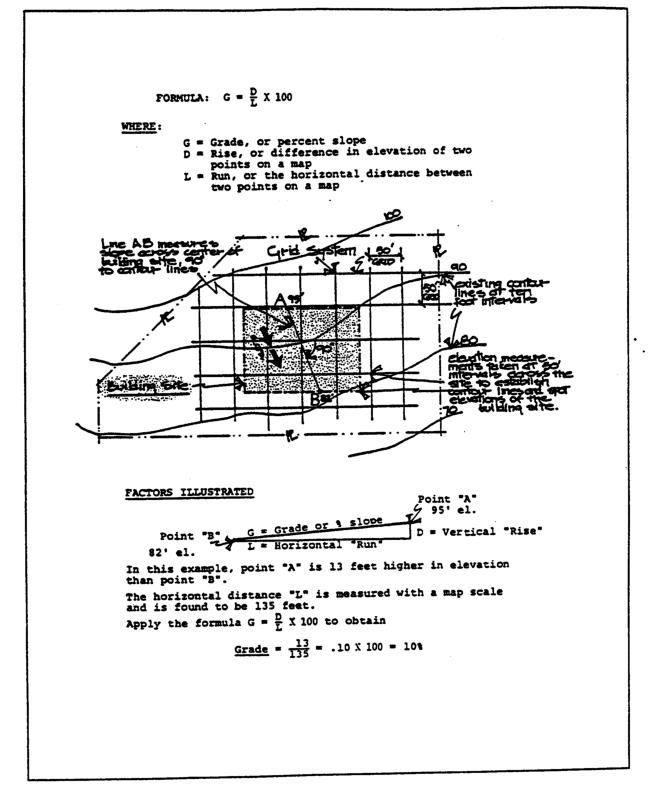
Figure 18.61-2
Measurement of Protected Area
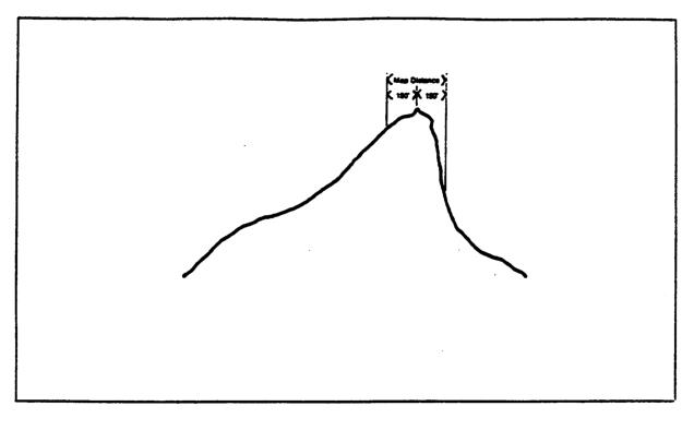
Figure 18.61-3
Suggested Treatment for Exposed Fill
[Ord. 2011-048 § 1; Ord. 1995-06 § 2.]