


Chapter 16.78
URBAN LOT SPLITS
Sections:
16.78.030 Objective standards.
16.78.040 Parcel map application review and action.
16.78.050 Use and development requirements.
16.78.010 Purpose and intent.
This chapter contains requirements for urban lot splits to implement Government Code Section 66411.7. These requirements are necessary to preserve the public health, safety, and general welfare, and to promote orderly growth and development. In cases where a requirement in this chapter directly conflicts with Government Code Section 66411.7, the Government Code governs. (Ord. 1052 § 3 (Att. 1), 2022)
16.78.020 Eligibility.
A. Parcel Map Required. A parcel map is required for all urban lot splits pursuant to Government Code Section 66411.7.
B. Requirements to Accept Application. The city shall accept a parcel map application for an urban lot split only if the application complies with all of the following requirements:
1. Existing Parcel Size. The area of the existing parcel is two thousand four hundred square feet or more.
2. Number of New Parcels. The urban lot split creates no more than two new parcels.
3. New Parcel Size. The area of each newly created parcel is:
a. At least one thousand two hundred square feet; and
b. No smaller than forty percent of the parcel area of the original parcel.
4. Zoning District. The parcel is located within the residential single-family (R-1) zoning district.
5. Environmental Resources and Hazards.
a. The parcel satisfies the requirements of Government Code Sections 65913.4(a)(6)(B) to (K), inclusive, which prohibits development on sites subject to specified environmental resources and hazards.
b. The parcel is not located in any of the following areas as identified in the city’s certified local coastal program:
i. Geological hazard areas.
ii. One-hundred-year and/or five-hundred-year flood hazard areas.
iii. Environmentally sensitive hazard habitat areas (ESHA).
6. Affordable and Rental Housing. The proposed urban lot split would not require demolition or alteration of any of the following types of housing:
a. Housing that is subject to a recorded covenant, ordinance, or law that restricts rents to levels affordable to persons and families of moderate, low, or very low income.
b. Housing that is subject to any form of rent or price control through a public entity’s valid exercise of its police power.
c. A parcel or parcels on which an owner of residential real property has exercised the owner’s rights under Chapter 12.75 (commencing with Section 7060) of Division 7 of Title 1 of the Government Code (the Ellis Act) to withdraw accommodations from rent or lease fifteen years before the date that the development proponent submits an application.
d. Housing that has been occupied by a tenant in the last three years based on the date of the application for an urban lot split.
7. Historic Resources.
a. The parcel is not located within a historic district or property included on the State Historic Resources Inventory, as defined in Section 5020.1 of the Public Resources Code.
b. The parcel is not located on a site which includes a structure that is a designated historic resource or that meets the criteria provided in Section 17.84.020(B) to qualify as a designated historic resource.
8. No Prior Urban Lot Split.
a. The parcel has not been established through prior exercise of an urban lot split provided for in Government Code Section 66411.7.
b. Neither the owner of the parcel being subdivided nor any person acting in concert with the owner has previously subdivided an adjacent parcel using an urban lot split as provided for in this chapter. (Ord. 1052 § 3 (Att. 1), 2022)
16.78.030 Objective standards.
All urban lot splits shall comply with the following standards, unless the applicant can demonstrate that a standard would have the effect of physically precluding the construction of two units on either of the resulting parcels or would preclude a unit size of eight hundred square feet for either unit:
A. Parcel Line Angles. New parcel lines that abut a street shall maintain right angles to streets or radial to the centerline of curved streets, or be parallel to existing parcel lines.
B. Street Frontage/Flag Lots. Parcels without twenty feet or more of frontage on a street are not permitted, except that flag lots are permitted if:
1. The front corridor portion of the flag lot is at least five feet in width; and
2. The lot shares with the other newly created lot a driveway or private road at least ten feet in width and no more than forty percent of the parcel width or twenty feet, whichever is less.
C. Parking.
1. Number of Spaces.
a. A minimum of one off-street parking space shall be provided for each dwelling unit except that no parking is required where the parcel satisfies one or more of the following circumstances:
i. The parcel is located within one-half mile walking distance of either a high-quality transit corridor, as defined in Section 21155(b) of the Public Resources Code, or a major transit stop, as defined in Section 21064.3 of the Public Resources Code.
ii. There is a car share vehicle located within one block of the parcel. A “car share vehicle” means a motor vehicle that is operated as part of a regional fleet by a public or private car sharing company or organization that meet all the following criteria:
(A) Provides hourly or daily service;
(B) Vehicle reservations are processed and paid for using an online system;
(C) Vehicles can be accessed where they are parked without having to go to a different physical location to execute a contract and/or pick up the keys; and
(D) Fleet has more than five cars in Capitola and more than twenty cars in Santa Cruz County.
b. The exception for parcels that satisfy subsection (C)(1)(a)(i) or (ii) of this section does not apply to areas identified in Figure 1.
Figure 1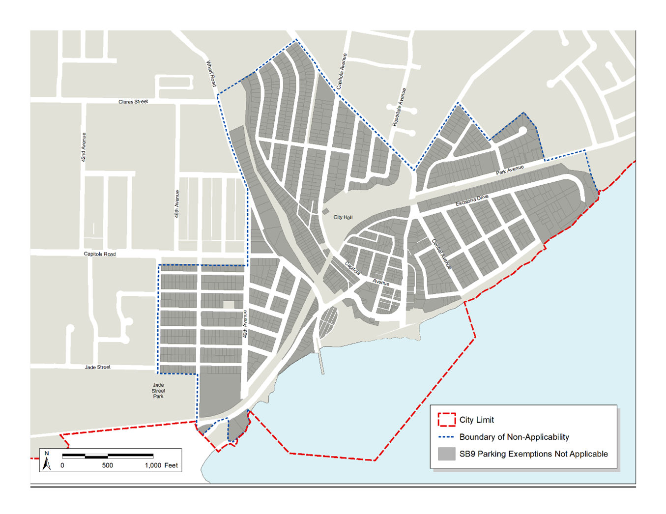
2. Shared Driveways.
a. Both newly created parcels shall share one driveway providing vehicle access to the parcels. A maximum of one curb cut is permitted to serve both newly created parcels.
b. The maximum width of the new driveway crossing a public sidewalk is twelve feet.
D. Access to Public Right-of-Way. The newly created parcels shall provide access to or adjoin the public right-of-way, sufficient to allow development on the parcel to comply with all applicable property access requirements under California Fire Code Section 503 (Fire Apparatus Access Roads) and 14 CCR Section 1273.00 et seq. (Intent).
E. Setbacks.
1. No setback is required for an existing structure or a structure reconstructed in the same location and to the same dimensions as an existing structure. In all other circumstances minimum setbacks consistent with Section 17.75.050 (Objective Development Standards) are required.
2. Within the coastal zone, structures must comply with minimum setbacks from environmentally sensitive habitat areas and geologic hazards as specified in Chapter 17.64 of this code (Environmentally Sensitive Habitat Areas) and Chapter 17.68 of this code (GH Geologic Hazards District).
3. Verification of size and location of the existing and proposed structure requires pre- and post-construction surveys by a California-licensed land surveyor.
F. Existing Structure on One Parcel. The proposed lot split shall not result in the splitting of any structure between the two parcels and shall not create a new encroachment of an existing structure over a property line.
G. Residential Land Use. The proposed new parcels must be intended for residential use.
H. Floor Area Calculation. Floor area calculation exclusions in Section 17.48.040(B)(6) do not apply to an SB 9 residential development.
I. Compliance with Subdivision Requirements. The parcel map shall satisfy the objective requirements of the Subdivision Map Act and this title regarding parcel maps, including Chapter 16.24 of this code (Design Standards), except as provided in this chapter. (Ord. 1052 § 3 (Att. 1), 2022)
16.78.040 Parcel map application review and action.
A. Application Contents. A parcel map application for an urban lot split must be filed with the community development department on an official city application form. Applications shall be filed with all required fees, information, and materials as specified by the community development department. At a minimum, an application package shall include the following:
1. Title report showing the current ownership and all liens and encumbrances.
2. Copies of deeds for all properties included in the request.
3. A plat map drawn to scale by a licensed land surveyor or registered civil engineer depicting all of the following:
a. Existing and proposed parcel lines.
b. Location of easements required for the provision of public services and facilities to each of the proposed parcels.
c. Location of any easements necessary for each parcel to have access to the public right-of-way.
d. Survey of existing conditions signed and stamped by licensed land surveyor or civil engineer.
e. Site plan with existing conditions, proposed parcel lines, driveways, and location of utility easements.
4. An affidavit, signed by the property owner under penalty of perjury, declaring all of the following to be true:
a. Any housing units proposed to be demolished or altered have not been occupied by a tenant at any time within three years of the date of the application for an urban lot split.
b. The owner of the parcel intends to occupy one of the housing units as their principal residence for a minimum of three years from the date of the approval of the urban lot split. Owner-occupancy is not required if the owner is a community land trust or qualified nonprofit corporation under Section 214.15 or 402.1 of the Revenue and Taxation Code.
c. The owner has not previously subdivided an adjacent parcel using an urban lot split.
d. The owner has not previously acted in concert with any person to subdivide an adjacent parcel using an urban lot split. “Acted in concert” means that the owner, or a person acting as an agent or representative of the owner, knowingly participated with another person in joint activity or parallel action toward a common goal of subdividing the adjacent parcel.
B. Ministerial Approval. The community development director shall ministerially approve a parcel map for an urban lot split if the application complies with all requirements of this chapter. No public hearing or discretionary review is required.
C. Basis for Denial.
1. The community development director shall deny the urban lot split if either of the following is found:
a. The urban lot split fails to meet or perform one or more objective requirements imposed by the Subdivision Map Act or by this chapter. Any such requirement or condition that is the basis for denial shall be specified by the community development director in writing.
b. The building official makes a written finding, based upon a preponderance of the evidence, that the proposed subdivision would have a specific, adverse impact, as defined and determined in Section 65589.5(d)(2) of the Government Code, upon public health and safety or the physical environment and for which there is no feasible method to satisfactorily mitigate or avoid the specific, adverse impact.
2. For an urban lot split in the coastal zone, the community development director shall deny the application upon finding that the development is inconsistent with policies of the local coastal plan and/or will have an adverse impact on coastal resources.
3. The community development director shall not deny an urban lot split solely because it proposes adjacent or connected structures; provided, that the structures meet building code safety standards and are sufficient to allow separate conveyance.
D. Conditions of Approval.
1. Easements. The community development director shall condition parcel map approval on the dedication of any easements deemed necessary for the provision of public services to the proposed parcels and any easements deemed necessary for access to the public right-of-way.
2. Nonconforming Zoning Conditions. The community development director may not require the correction of nonconforming zoning conditions on the parcel a condition of parcel map approval.
E. Within Coastal Zone.
1. A proposed urban lot split that is located in the coastal zone may require a coastal development permit (CDP) as specified by Chapter 17.44 of this code (Coastal Overlay Zone) and the findings for approval of a CDP as specified in Section 17.44.130 (Findings for approval).
2. A public hearing for a CDP application for an urban lot split is not required.
3. Nothing in this chapter shall be construed to supersede or in any way alter or lessen the effect of application of the California Coastal Act of 1976 (Division 20, commencing with Section 30000, of the Public Resources Code). (Ord. 1052 § 3 (Att. 1), 2022)
16.78.050 Use and development requirements.
A. Short-Term Rentals Prohibited. It is unlawful to use a dwelling unit constructed on a parcel created under this chapter for vacation rentals as defined in Chapter 17.160 (Glossary).
B. Residential Use. The primary use of a dwelling unit constructed on a parcel created under this chapter must be residential.
C. Maximum Unit Size. New dwelling units constructed on a parcel created under this chapter shall be no more than eight hundred square feet in floor area, or one thousand two hundred square feet if each newly created parcel contains only one dwelling unit.
D. Compliance with Zoning Requirements
1. New dwelling units constructed on a parcel created under this chapter are subject to the requirements of Chapter 17.75 of this code (SB 9 Residential Developments) and shall also comply with all applicable objective zoning requirements set forth in the zoning code.
2. The standards described in subsection (D)(1) of this section apply to all urban lot splits except where a standard directly conflicts with a provision of this chapter, or where the applicant demonstrates that a standard would:
a. Have the effect of physically precluding the construction of two units on either of the newly created parcels; or
b. Necessarily result in a unit size of less than eight hundred square feet.
E. Maximum Number of Dwelling Units. Notwithstanding any other provision of the municipal code, no more than two dwelling units, including any accessory dwelling units or junior accessory dwelling units, are permitted on a parcel created under this chapter. (Ord. 1052 § 3 (Att. 1), 2022)
16.78.060 Deed restrictions.
A. Before obtaining a building permit for a dwelling unit constructed on a parcel created under this chapter, the property owner shall file with the county recorder a declaration of restrictions containing a reference to the deed under which the property was acquired by the current owner. The deed restriction shall state that:
1. The maximum size of the dwelling unit is limited to one thousand two hundred square feet for two-unit projects and eight hundred square feet for three- and four-unit projects;
2. The primary use of the unit must be residential;
3. Use of shared driveway must be permanently provided and maintained for both newly created parcels through a reciprocal access easement or other comparable mechanism; and
4. The unit may not be used for vacation rentals as defined in Chapter 17.160 of this code (Glossary).
B. The above declarations are binding upon any successor in ownership of the property. Lack of compliance shall be cause for code enforcement.
C. The deed restriction shall lapse upon removal of all dwelling units established on a parcel created under this chapter. (Ord. 1052 § 3 (Att. 1), 2022)