


Division III. Overlay and Community Plan Districts
Chapter 17.20
OVERLAY DISTRICTS1
Sections:
Article I. General Provisions
17.20.010 Purpose and Applicability.
Article II. AS Archaeological Significance Overlay District
17.20.030 Boundaries of the Archaeological Significance Overlay District.
17.20.050 Additional Requirements.
Article III. Park Overlay District
17.20.080 Boundaries of the Park Overlay District.
17.20.100 Required Planning Commission Review.
Article IV. Beach and Riparian Overlay District
17.20.140 Boundaries of the Beach and Riparian Overlay District.
17.20.150 Coastal Development Permit Required.
17.20.170 Application Content – Additional Requirements.
17.20.190 Shoreline Protection.
17.20.200 Regulations Incorporated from Other Titles.
Article V. Environmentally Sensitive Habitat Area Overlay District
17.20.220 Environmentally Sensitive Habitats.
Article VI. Annexed County Lots Overlay District
17.20.240 Boundaries of C Overlay District.
Article VII. Downtown Conservation District
17.20.270 Boundaries of the Downtown Conservation District.
17.20.280 Procedures and Criteria for Review.
Article I. General Provisions
17.20.010 Purpose and Applicability.
Overlay districts are zoning districts established by the City to carry out specific purposes. They are governed by a set of regulations that address specific subjects, such as archaeological significant resources or environmentally sensitive habitat areas. Overlay districts may be initially established by adding a specific article to this chapter without being actually delineated on a zoning map. At a later time, when an opportunity arises to carry out the intended purposes for one or more sites that meet the criteria for designation, the City Council may adopt an ordinance amending the zoning map to delineate the boundaries of the overlay district. The provisions of the overlay district will then be combined with the provisions of the base zoning district for that site or sites to which the overlay district applies and the more restrictive provisions will govern. (Ord. 2004-02 § 1, 2004; Ord. 2004-01 § 1, 2004).
Article II. AS Archaeological Significance Overlay District
17.20.020 Purposes.
The purposes of the AS archaeological significance overlay district are to implement the General Plan/Coastal Plan Land Use Plan and to:
A. Protect archaeological sites in Carmel that can provide evidence of the area’s earliest human habitation, help to document the cultural history of the City, and are often highly significant to Native American descendants as burial grounds or because of their connection to sacred traditions.
B. Provide for the designation of archeological resources and establish explicit guidance for the protection of archeological resources, especially when they are subterranean.
C. Create a clear process and standards for evaluating projects that may affect archaeological resources, and for identifying appropriate measures to mitigate the effects of such projects. (Ord. 2004-02 § 1, 2004; Ord. 2004-01 § 1, 2004).
17.20.030 Boundaries of the Archaeological Significance Overlay District.
The boundaries of the AS district are shown schematically on Figures III-1 through III-6. A definitive listing of all properties affected is included with each figure. (Ord. 2004-02 § 1, 2004; Ord. 2004-01 § 1, 2004).
17.20.040 Minimum Standards.
The following standards shall apply to all building sites located in the AS district or within any commercial or R-4 district.
A. Applications for new construction or additions, alterations and remodels involving excavation of undisturbed earth shall include an Archaeological Resource Management Report, prepared pursuant to the guidelines established in CMC 17.32.060.
Figure III-1 Archaeological Significance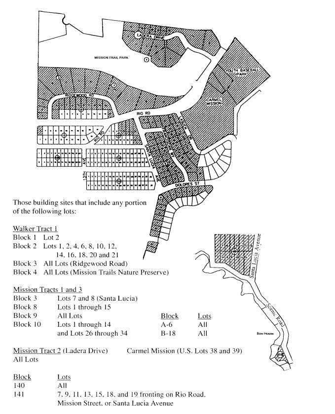
Figure III-2 Archaeological Significance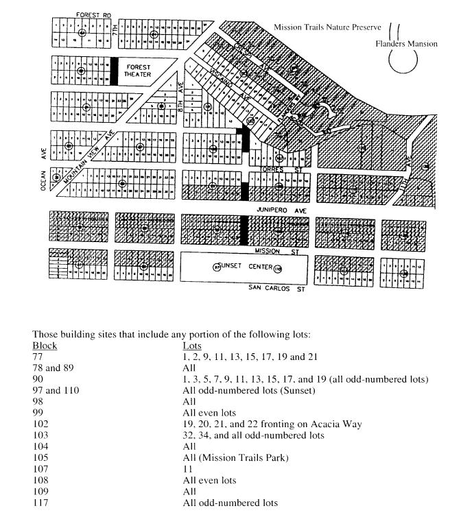
Figure III-3 Archaeological Significance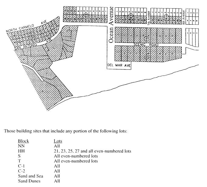
Figure III-4 Archaeological Significance
Figure III-5 Archaeological Significance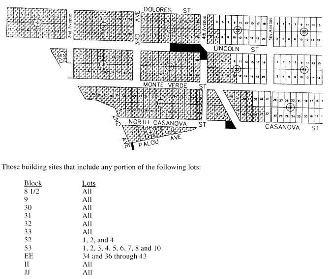
Figure III-6 Archaeological Significance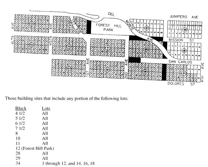
(Ord. 2004-02 § 1, 2004; Ord. 2004-01 § 1, 2004).
17.20.050 Additional Requirements.
All projects subject to this section shall be subject to the following additional requirements:
A. If any human remains are found at any time during construction, work shall stop and the applicant or his/her agent on the site shall immediately notify the Monterey County Coroner in compliance with applicable State requirements.
B. Exceptions. This section does not apply to emergency repairs that the City Administrator determines necessary to avoid disruption of existing utility service. (Ord. 2004-02 § 1, 2004; Ord. 2004-01 § 1, 2004).
17.20.060 Report Guidelines.
The “Archaeological Resource Management Reports (ARMR): Recommended Contents and Format” (cited as the ARMR Guidelines, which were prepared by the California Office of Historic Preservation and attached as Appendix G2 to this title) shall be used as guidelines for preparation of reports required by this article. The Planning Commission and the Department of Community Planning and Building shall use these ARMR Guidelines to review proposed construction and mitigation for potential impacts on archaeological resources. Project plans that fail to achieve reasonable compliance with these ARMR Guidelines shall not be approved. (Ord. 2004-02 § 1, 2004; Ord. 2004-01 § 1, 2004).
Article III. Park Overlay District
17.20.070 Specific Purposes.
The specific purposes of the park overlay district are to implement the General Plan/Coastal Plan Land Use Plan and to ensure that development of private property adjacent to parks and open spaces is compatible with their continued enjoyment. It is the intent of these regulations to protect park resources from the visual and physical impacts that may be associated with development of private property near designated parklands, to enhance the public enjoyment of parks and to preserve the habitat values of parks. (Ord. 2004-02 § 1, 2004; Ord. 2004-01 § 1, 2004).
17.20.080 Boundaries of the Park Overlay District.
The boundaries of the PO district are shown schematically on Figures III-7 through III-10. A definitive listing of all properties affected is included with each figure. (Ord. 2004-02 § 1, 2004; Ord. 2004-01 § 1, 2004).
17.20.090 Minimum Standards.
The following standards regulating construction activity and use shall apply to all building sites located in the park overlay district. The provisions of the park overlay district shall be coordinated with the ESHA overlay district whenever a property is located within both overlay districts.
A. The site design must include a drainage plan that is adequate to prevent erosion and excess runoff as determined by the Building Official. The site shall be connected to the sanitary sewer system.
B. No tree shall be removed within the park overlay district without written approval from the City Forester regardless of whether the removal is associated with construction activities.
C. All proposed construction must maintain a setback of at least 15 feet from any property line that also constitutes a park boundary. However, this special setback shall not apply to property across the street from a park. The Planning Commission may modify other setbacks through the design review process to provide flexibility for properties unreasonably restricted by this required park setback.
D. When any construction activity is proposed on a site in the park overlay district, the site design shall include a landscaping plan in accordance with Chapter 17.34 CMC, Landscaping.
Figure III-7 Forest Hill Park
Forest Hill Park Overlay: Those building sites that include all or portions of the following lots:
|
Block |
Lots |
|
5 1/2 |
9, 11, 13, 15, 17 and 19 fronting on Junipero Avenue |
|
7 |
Those portions of Lots 1, 2, 4, 6, 8, and 10 fronting on Camino Del Monte |
|
7 1/2 |
19 fronting on Mission Street |
|
8 |
1, 3, 5, 7, 9, 11, 13, 15, 17, 18, 19, all of 20 fronting on Junipero or First Avenues |
|
11 |
All odd-numbered lots fronting on Mission Street |
|
13 |
1, 2, 4, 6, 8, 10, 11, 12, 14, 16, 18, 20, 21, 22, 24 and 26 fronting on Junipero Avenue |
|
26 |
1, 2, and 4 fronting on Junipero Avenue |
|
27 |
1, 2, 3, 4, 5, 6, 7 and 8 fronting on Camino Del Monte |
|
28 |
1 and 3 fronting on Mission Street |
Figure III-8 Mission Train Nature Preserve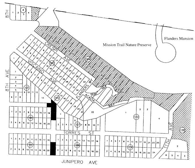
Mission Trails Nature Preserve Overlay: Those building sites that include all or portions of the following lots:
|
Block |
Lots |
|---|---|
|
4 (Paradise Park) |
5 |
|
104 |
All lots contiguous with Mission Trail Nature Preserve |
|
128 |
All lots contiguous with Mission Trail Nature Preserve |
Figure III-9 Mission Trail Nature Preserve
Mission Trails Nature Preserve: Those building sites that include all or portions of the following lots:
|
Block |
Lots |
|---|---|
|
Walker Tract 1, 3 (Ridgewood Road) |
5, 6, 7, 8, 9, 10, 11, 12, 13, and 14 contiguous with Mission Trail Nature Preserve |
|
Walker Tract 2, 4 (Ladera Drive) |
1, 2, 3, 5, 6, 7, 8, 9, 16, and 17 contiguous with or across the street from Mission Trail Nature Preserve |
|
Carmel Mission (U. S. Lots 38 and 39) |
All lots across the street from Mission Trail Nature Preserve |
Figure III-10 Forest Theater Park
Forest Theater Park Overlay: Those building sites that include all or portions of the following lots:
|
Block |
Lots |
|---|---|
|
81 |
21, 23, 25, and 26 fronting on Santa Rita Street |
|
82 |
19, 20 abutting Forest Theater Park |
|
83 |
9 fronting on Guadalupe Street |
|
84 |
All even-numbered lots fronting on Guadalupe Street |
|
86 |
1 fronting on Mountain View Avenue |
|
101 |
1 adjacent to Mountain View Avenue |
|
102 |
1 adjacent to Mountain View Avenue |
|
103 |
2 adjacent to Mountain View Avenue |
(Amended during 8/09 update; Ord. 2004-02 § 1, 2004; Ord. 2004-01 § 1, 2004).
17.20.100 Required Planning Commission Review.
In addition to any other reviews required by this code, the following types of projects in the park overlay district shall require Planning Commission review:
A. Projects located on nonrectangular building sites for which the Commission has not established setbacks during prior approvals;
B. Projects located on building sites larger than 8,000 square feet in area for which the Commission has not established setbacks during prior approvals and/or which do not qualify for administrative design review (track one) approval;
C. Projects of more than one story and/or taller than 18 feet in height;
D. Projects involving construction of a new dwelling unit or demolition of an existing dwelling unit; and
E. Projects that, in the opinion of the Director of Community Planning and Building, represents a substantial deviation from standard design and construction practices in the neighborhood and is not addressed by these regulations or which otherwise may be inconsistent with the purposes of this district or the General Plan. (Ord. 2004-02 § 1, 2004; Ord. 2004-01 § 1, 2004).
17.20.110 Review Criteria.
Proposed projects requiring Planning Commission review as established in CMC 17.20.100 shall require approval through the track two design study process (see Chapter 17.58 CMC, Design Review), using the following standards prior to the issuance of any building permits.
A. Projects Exceeding the Limits on Number of Stories and/or Height. The Planning Commission may grant approval of:
1. A second story;
2. An increase in building height up to a maximum of 24 feet; and
3. Approvals granted under this section shall not violate any height limits established for the property by the underlying zoning district or any other overlay districts. In granting approval for these increases, the Commission shall make the following findings:
a. That due to the topography of the site relative to the adjoining park or open space land, the proposed building would not exceed the height or bulk of an 18-foot one-story structure built on a site at the same grade as the adjoining park or that topography and height are irrelevant because of the location of the building on the site avoids view of the buildings from the park.
b. That those portions of the building visible from the park will exhibit a human scale and residential character through the use of simple building forms and natural materials that will not detract from the enjoyment of the park or open space by the public.
B. Projects Requiring Modified Setback Standards. Through the track two design study process, the Planning Commission may approve an adjustment of setbacks on park overlay district properties from those normally required in order to preserve equity in the amount of buildable area on a lot after application of the 15-foot setback from park boundaries required by CMC 17.20.090, Minimum Standards. Sites with a side lot line adjacent to parklands that cannot obtain a satisfactory modification of setbacks through this procedure may apply for a variance to reduce the width of the 15-foot setback from the park boundary. In granting requests for modified setbacks, the Planning Commission shall make the findings listed below.
1. That the total area of all setbacks is approximately equal to the area of the lot that would be contained in setbacks if the increased setback from the park established in CMC 17.20.090, Minimum Standards, were applied.
2. That a minimum width of at least three feet will be maintained for the full length of all setbacks.
3. That by reducing any setbacks, the proposed structure will not interfere with safe access to other properties in the neighborhood or otherwise result in damage or injury to the use of other adjoining properties.
4. That structures proposed for construction within reduced setback areas will be compatible with the residential character of the neighborhood and will exhibit a human scale without excessive building bulk or visual mass.
C. Projects on Irregularly Shaped Lots or Lots Larger Than 8,000 Square Feet. On those lots that are irregular in shape or that exceed 8,000 square feet in area, the Planning Commission shall establish setbacks that are appropriate for the property and that are consistent with the purposes of the PO district. Where a large lot size creates an opportunity to establish significantly increased setbacks from adjoining parklands, and the topography or shape of the site allow sufficient area to build away from the park, the Planning Commission may designate larger setbacks for the property that preserve an open space buffer adjacent to the park while providing a reasonable area to build elsewhere on the property.
D. In designating these setbacks the Commission must adopt the findings listed in subsection (B) of this section and the following findings:
1. That the proposed setbacks afford maximum protection for the adjoining parklands for the benefit of the public while still accommodating reasonable development of the property.
2. That the proposed setbacks are designated on an approved plan attached to the permit or on a scenic easement for purposes of documentation and recordation. (Ord. 2004-02 § 1, 2004; Ord. 2004-01 § 1, 2004).
Article IV. Beach and Riparian Overlay District
17.20.120 Purpose.
The purpose of the beach and riparian overlay district is to provide review standards applicable to public and private property development located near public beach lands to ensure that proposed development is compatible with the public enjoyment of the City’s coastal resources and with the California Coastal Act. (Ord. 2004-02 § 1, 2004; Ord. 2004-01 § 1, 2004).
17.20.130 Applicability.
The regulations of this article shall apply in the beach and riparian overlay district. The beach overlay district is an overlay district, which may be combined with any of the other districts specified in the municipal code. The provisions of the beach and riparian overlay district shall be coordinated with the ESHA overlay district whenever a property is located within both overlay districts. The regulations of this article shall apply in addition to the regulations of any district with which the beach and riparian overlay district is combined. In the event of any perceived conflict between the provisions of this article and any other provision of these regulations, this article shall control. (Ord. 2004-02 § 1, 2004; Ord. 2004-01 § 1, 2004).
17.20.140 Boundaries of the Beach and Riparian Overlay District.
The beach and riparian overlay district shall be coterminous with the California Coastal Commission’s coastal development permit appeal jurisdiction and shall include all public and private property, wholly or in part, within the boundaries of the appeal jurisdiction described in CMC 17.54.020. The boundaries of the beach and riparian overlay district are shown schematically on the official zoning map maintained by the Planning Director. (Ord. 2004-02 § 1, 2004; Ord. 2004-01 § 1, 2004).
17.20.150 Coastal Development Permit Required.
Unless exempted by CMC 17.52.100, Development Excluded from Coastal Permit Requirements, all new development, as defined by Chapter 17.70 CMC, shall require a coastal development permit, in addition to any other permit(s) required by law. Development undertaken pursuant to such a permit shall conform to the plans, specifications, terms and conditions approved in granting the permit. Notice, hearing and appeal procedures shall be established in Chapter 17.52 CMC, Permit Procedures, and Chapter 17.54 CMC, Appeals.
Figure III-11 Carmel Beach and Riparian Overlay District
(Figure to be provided by the California Coastal Commission)
Figure III-12 Carmel Beach and Riparian Overlay District
(Figure to be provided by the California Coastal Commission)
(Ord. 2004-02 § 1, 2004; Ord. 2004-01 § 1, 2004).
17.20.160 Permit Standards.
The following standards shall be used by decision-making bodies in approving or denying a coastal development permit in the beach and riparian overlay district. The regulations in subsection (A) of this section apply to all properties in the overlay district. The regulations in subsection (B) of this section apply to only those properties in the overlay district located west of Carmelo or North San Antonio Avenue. No building permit for any development, as defined in Chapter 17.70 CMC, including but not limited to new construction, additions, exterior alterations or change in land use shall be approved unless a coastal development permit is approved taking into consideration all of the following as may be appropriate to the scope of the project.
A. Regulations Applicable to All Properties in the Overlay District.
1. View Protection. Permitted development shall be sited and designed to protect public views to and along the ocean and scenic coastal areas, to minimize the alteration of natural landforms, to be visually compatible with the character of the surrounding areas, and where feasible, to restore and enhance visual quality in visually degraded areas, while ensuring the private property owner reasonable development of the land.
2. Location. All development shall be located and designed to avoid conflict with recreational use of any adjacent public property or conflict with coastal resources.
3. Design Compatibility. All development shall be compatible in design with existing buildings in the area for the purpose of protecting the neighborhood character and consistent with the R-1 design guidelines established in CMC 17.10.010.
4. Review of City Needs. The property has been reviewed for potential acquisition and the review indicated the City has no need to acquire the property.
5. Utilities. All utilities connecting the development to the source in the public rights-of-way shall be placed underground.
6. Sewer Services. The property shall be connected to the sanitary sewer system upon issuance of the permit. Alternatively, the Planning Commission may authorize an area-wide agreement among several adjacent properties (executed through no-protest agreements) for future connection to the sanitary sewer if the infrastructure for a single connection would place an undue burden on a single property owner.
7. Drainage. A drainage system shall be provided for all new development to minimize erosion, minimize runoff, and to infiltrate and filter stormwater prior to conveyance off-site.
8. Projects on Irregularly Shaped Lots or Lots Larger Than 8,000 Square Feet. On those lots that are irregular in shape or that exceed 8,000 square feet in area, the Planning Commission shall establish setbacks that are appropriate for the property and that are consistent with the purposes of the beach and riparian overlay district. Where a large lot size creates an opportunity to establish significantly increased setbacks from adjoining beach lands, and the topography or shape of the site allow sufficient area to build away from the beach, the Planning Commission may designate larger setbacks for the property that preserve an open space buffer adjacent to the beach while providing a reasonable area to build elsewhere on the property.
B. Regulations Applicable to Properties in the Overlay District Located West of Carmelo Street or North San Antonio Avenue.
1. Access. Development shall not interfere with the public’s right of access to the sea. Potential public right of access shall be reviewed on the property and, where appropriate, made a condition in the permit.
2. Subdivision Limitations. No further subdivision shall be approved within the beach and riparian overlay district. No lot line adjustments shall be approved that would result in a net increase in potential building sites.
3. Height. All proposed construction shall be limited to a height of 18 feet above the existing grade or finished grade whichever results in a lower height.
4. Open Space. On sites adjacent to the beach all buildings shall be located to preserve maximum open space on the site as viewed from the beach. Generally, a setback of at least 15 feet shall be maintained along any property line facing the beach. The Planning Commission may at its discretion reduce any required rear, side or front yard to not less than three feet so as to preserve maximum open space on the site adjacent to the beach for public benefit.
5. Tree Removal. No tree shall be removed within the beach and riparian overlay district without written approval from the City Forester regardless of whether the removal is associated with construction activities. Trees on City property shall be trimmed and/or removed only by City tree crews or under the supervision of the City Forester. Removal of dead cypress trees on City property in this district shall require approval by the Forest and Beach Commission. When any construction activity is proposed on a site in the beach and riparian overlay district, the site design shall include a landscaping plan consistent with the provisions of Chapter 17.34 CMC, Landscaping.
6. Prohibition on Private Development Needing Protection. Except as provided in CMC 17.20.190(C), new development shall not be approved where geologic evidence concludes that shoreline protective structures will be necessary to protect the new development at the time of construction, or within 100 years of development.
7. Public Structures. Stairs, retaining walls, fences, pipelines, and similar public or quasi-public facilities located on coastal bluffs shall require a coastal development permit.
8. Parking. On sites of 6,000 square feet or greater, two on-site parking spaces per primary dwelling unit shall be provided for all new residential development in the beach and riparian overlay district. One of these spaces may be established as an uncovered tandem space within the front or side yard setback located on the driveway in front of a garage or carport or elsewhere on the property where parking is allowed by the underlying zoning district.
9. Setbacks. Private development proposed on ocean-fronting parcels shall comply with the setback requirements of the applicable primary zoning district, except where a lot line is adjacent to a coastal bluff or sand dunes, or where public access and/or recreational areas are required in compliance with these regulations. Proposed private developments shall be set back from the top of the bluff or adjacent sand dunes as provided by this subsection.
a. Bluff Retreat Setback Requirements. New structures shall be set back a sufficient distance from any bluff top to be safe from bluff erosion for a minimum of 100 years as determined by a site-specific geology report, prepared in compliance with CMC 17.20.170(B), Geology Report; provided, that in no case shall the minimum setback be less than 25 feet.
b. Use of Bluff Retreat Setbacks. No development except public access pathways, public restrooms, stairways and associated public recreational or infrastructure facilities shall be permitted within the bluff retreat setbacks identified in site-specific geologic reports.
c. Dune, Access and Recreational Area Setbacks. Additional bluff top and/or dune setbacks may be required in compliance with Local Coastal Plan policies to establish a buffer from natural sand dune areas, to reduce visual intrusion on adjacent recreational areas or to accommodate public access and enjoyment of adjacent recreational areas. (See also CMC 17.20.180, Public Access).
10. Findings Required. In designating beach and riparian overlay district setbacks for private property the Commission shall adopt the following findings:
a. That the combined area contained within all setbacks is at least equal to the area of the lot that would be included within setbacks if the special beach setback established in subsection (B)(9) of this section were applied (i.e., achieving no net loss of setback area).
b. That a minimum width of at least three feet will be maintained for the full length of all setbacks.
c. That by reducing any setbacks the proposed structure will not interfere with safe access to other properties in the neighborhood or otherwise result in damage or injury to the use of other adjoining properties.
d. That structures proposed for construction within reduced setback areas will be compatible with the residential character of the neighborhood and will exhibit a human scale without excessive building bulk or visual mass.
e. That the proposed setbacks afford maximum protection for the adjoining parklands for the benefit of the public while still accommodating reasonable development of the property.
f. That the proposed setbacks are designated on an approved plan attached to the permit or on a scenic easement for purposes of documentation and recordation. (Ord. 2004-02 § 1, 2004; Ord. 2004-01 § 1, 2004).
17.20.170 Application Content – Additional Requirements.
Permit applications for development on ocean-fronting parcels shall include the following information where applicable, in addition to all the information required by Chapter 17.52 CMC, Permit Procedures.
A. Erosion Control Plan. All development permit applications involving substantial alterations to existing buildings or site design, or construction of new buildings on ocean-fronting parcels shall include a site-specific erosion control plan. The plan shall be prepared by a registered engineer qualified in hydrology and soil mechanics, and shall ensure that the development will not contribute to the erosion or failure of any bluff face, and will eliminate or mitigate any adverse impacts on local shoreline sand supply to the maximum extent feasible. New development that (1) increases site coverage by more than two percent of the site area, or (2) involves grading that will affect drainage patterns on or off-site, or (3) involves either a rebuild demolition or construction of a new building or shoreline structure shall include a site specific erosion control plan that includes controls on grading (i.e., timing and amounts), best management practices for staging, storage, and disposal of construction materials, design specifications of sedimentation basins, and landscaping/revegetation of graded or disturbed areas. New development shall further include a site-specific polluted runoff control plan that demonstrates how runoff will be diverted from impermeable surfaces onto permeable areas of the property in a nonerosive manner to filter and infiltrate stormwater prior to conveyance off-site.
B. Geology Report. A geology report shall be required when structures are proposed within an area between the face of the bluff, and a line described on the bluff top by the intersection of a plane inclined at a 20-degree angle from horizontal, passing through the toe of the bluff or cliff, or 50 feet inland from the bluff top, whichever is greater.
C. Preparation and Contents of Geology Report. A required geology report shall be prepared by a qualified, licensed engineer approved by the City, and shall be submitted with the permit application for the proposed structure. The report shall consider, describe, and analyze the following:
1. Cliff geometry and site topography, extending the surveying work beyond the site as needed to depict unusual geomorphic conditions that might affect the site;
2. Historic, current, and foreseeable cliff erosion, including investigation of recorded land surveys and tax assessment records in addition to the use of historic maps and photographs where available, and possible changes in shore configuration and sand transport;
3. Geologic conditions, including soil, sediment, and rock types and characteristics, in addition to structural features such as bedding, joints, and faults;
4. Evidence of past or potential landslide conditions, the implications of such conditions for the proposed development, and the potential effects of the development on landslide activity;
5. Impact of construction activity on the stability of the site and adjacent area;
6. Ground and surface water conditions and variations, including hydrologic changes caused by the development (e.g., introduction of sewage, effluent, and irrigation water to the groundwater system, alterations to surface drainage, and the like);
7. Potential erodibility of the site and mitigation measures to be used to ensure minimized erosion problems before and after construction (i.e., landscape and drainage design);
8. Effects of marine erosion on the coastal bluffs;
9. Potential effects of seismic forces resulting from a maximum credible earthquake; and
10. Any other factors that might affect slope or bluff stability. (Ord. 2004-02 § 1, 2004; Ord. 2004-01 § 1, 2004).
17.20.180 Public Access.
This section establishes requirements for the dedication and improvement of public access to, and along the coast, in conjunction with proposed development and new land uses in order to ensure public rights of access to the coast are protected as guaranteed by the California Constitution. Coastal access standards established by this section also satisfy the California Coastal Act.
A. Protection of Existing Coastal Access. Development may not interfere with public rights of access to the sea where the rights were acquired through use or legislative authorization. Public access rights may include but are not limited to the use of dry sand and rocky beaches to the first line of terrestrial vegetation. Development shall not interfere with the public’s right of access to the sea by eliminating free public beach parking along Scenic Road, the Del Mar parking lot, and San Antonio from 2nd Avenue to Santa Lucia Avenue, or any street rights-of-way west of San Antonio.
B. Access Dedication Requirements. Proposed development and new land uses located between the ocean and the first public road may be required to provide vertical (perpendicular) access from the public road to bluff and beach areas, and lateral access along the beach, shoreline and bluff tops, where the review authority first makes specific findings documenting the need for additional public access on and/or through the site, and the relationship of the required dedication to the impacts on existing access, or needs for additional access created by the project.
C. Timing of Access Requirements. The type and extent of access to be dedicated, and/or constructed and maintained, as well as the method by which its continuing availability for public use is to be guaranteed, shall be established at the time of land use permit approval, as provided by this section.
1. Dedication. Shall occur before issuance of construction permits or the start of any construction activity not requiring a permit.
2. Construction of Improvements. Shall occur at the same time as construction of the approved development, unless another time is established through conditions of land use permit approval.
3. Interference with Public Use Prohibited. Following an offer to dedicate public access pursuant to this section; the property owner shall not interfere with use by the public of the areas subject to the offer before and after acceptance by the responsible entity.
D. Access Title and Guarantee. Where public coastal accessways are required by this section, approval of a subdivision, or land use permit for new development shall require guarantee of the access through deed restriction, or dedication of right-of-way or easement. Before approval of a land use permit or subdivision, the method and form of the access guarantee shall be approved by City Attorney, and shall be recorded in the office of the County Recorder, identifying the precise location and area to be set aside for public access. The method of access guarantee shall be chosen according to the following criteria:
1. Deed Restriction. Shall be used only where an owner, association or corporation agrees to assume responsibility for maintenance of and liability for the public access area, subject to approval by the Director.
2. Grant of Fee Interest or Easement. Shall be used when a public agency or private organization approved by the Planning Director is willing to assume ownership, maintenance and liability for the access.
3. Offer of Dedication. Shall be used when no public agency, private organization or individual is willing to accept fee interest or easement for accessway maintenance and liability. These offers shall not be accepted until maintenance responsibility and liability is established. (Ord. 2004-02 § 1, 2004; Ord. 2004-01 § 1, 2004).
17.20.190 Shoreline Protection.
A. Erosion Control. Proposed bluff top development shall be designed and constructed to incorporate appropriate erosion control measures, in compliance with the City’s grading standards.
B. Drainage Devices. New drainage devices extending over the bluff face shall not be permitted. Repair and maintenance shall be allowed for existing devices serving existing facilities. Construction of new dwellings and demolition of existing dwellings shall require abatement of existing private drainage devices that extend over the bluff face and all excess drainage shall be diverted from impermeable surfaces onto permeable areas of the property in a nonerosive manner to filter and infiltrate stormwater prior to conveyance to the City’s municipal drainage facilities. All new drainage structures shall be constructed so that drainage water will not spill over or onto the bluff face.
C. Shoreline Protective Structures. Shoreline protective structures may be permitted only when the review authority determines that the structure is:
1. Necessary to protect existing structures, coastal-dependent uses, public beaches, public access and beach facilities in danger of erosion;
2. The least environmentally damaging feasible alternative;
3. Designed to successfully eliminate or mitigate adverse impacts on local shoreline and sand supply;
4. Designed to avoid significant intertidal or subtidal areas;
5. Designed to avoid, or minimize if avoidance is infeasible, impacts on beach access; and
6. Designed to respect natural landforms and minimize visual impact to the extent possible, through means including the use of structures, colors and materials that are visually compatible to those already established.
D. Structures on Sandy Beach. No permanent structures shall be permitted on the dry sandy beach except facilities necessary for public health and safety.
E. Shoreline Armoring Maintenance and Monitoring.
1. Monitoring. The permittee shall ensure that the condition and performance of existing seawalls and revetments are regularly monitored by a licensed civil engineer with experience in coastal structures and processes. Such monitoring evaluation shall at a minimum address whether any significant weathering or damage has occurred that would adversely impact its future performance, and identify any structural damage requiring repair to maintain the as-built revetment profile.
2. Reports. At a minimum, annual monitoring reports shall be prepared by a licensed civil engineer with experience in coastal structures and processes and shall contain recommendations, if any, for necessary maintenance, repair, changes or modifications to the existing revetment or the bedrock benches adjacent to and below it. All monitoring reports shall include photos of the structures and surrounding areas taken during low sand elevations in the winter months.
3. Maintenance Activities. It is the permittee’s responsibility to maintain any shoreline armoring structures and all irrigation, drainage, and vegetation in a structurally sound manner and its approved state until such a time that the seawalls and/or revetments are removed or replaced. At a minimum, the permittee shall:
a. Rock Retrieval. Any armor rocks that move seaward of the as-built seawall and/or revetments shall be immediately retrieved and either: (1) restacked within the approved rock slope profile inland of the seawall; or (2) removed off the beach to a suitable disposal location. Any existing rock retrieved in this manner shall be recovered by excavation equipment positioned landward of the waterline (i.e., excavator equipment with mechanical extension arms).
b. Debris Removal. The permittee shall remove all materials and/or debris that may fall from the bluff top area inland of the seawall onto the beach below.
c. Landscaping and Drainage Maintenance. The permittee shall maintain all upper bluff drainage, vegetation, and/or irrigation elements above seawalls and/or revetments.
F. Shoreline Armoring Alternatives Analysis. Applicants shall submit a complete evaluation of a reasonable range of potential alternatives including (1) project alternatives that will avoid the need for armoring, including, but not limited to, relocation of the threatened (infra)structure(s) away from danger, (2) various armor solutions (e.g., vertical seawalls), (3) “soft” options, and (4) the “no project” alternative. The evaluation shall identify the environmentally least damaging feasible alternative that provides effective protection of existing development and minimizes impacts on public access, recreation, scenic resources, and sand supply.
G. Shoreline Armoring Construction Plan. Applicants shall submit a construction plan that identifies the specific location of all construction areas, all staging areas, and all construction access corridors in site plan view. Construction and staging zones shall be limited to the minimum area required to implement the approved project, and to minimize construction encroachment on the beach and intertidal areas, among other ways by using bluff top areas for staging and storing construction equipment and materials. The construction plan shall also identify the type and location of erosion control/water quality best management practices that will be implemented during construction to protect coastal water quality. (Ord. 2004-02 § 1, 2004; Ord. 2004-01 § 1, 2004).
17.20.200 Regulations Incorporated from Other Titles.
The following regulations apply in the beach overlay district.
A. Riding on Beach. Equestrians are allowed on the beach without restriction.
B. Dogs on Public Beach and Park Land. It is unlawful for the owner or person having charge of any dog to permit the dog to run at large on any City-owned beach lands or on any City-owned park lands unless the owner or person having charge is also present and in control of the dog at such time as it is running loose.
C. Dogs on Scenic Road and the Beach Bluff Pathway. On Scenic Road from its eastern property edge to the base of the beach embankment between Eighth Avenue and the south City limits, all dogs and other animals shall be deemed running at large within the meaning of this chapter unless led or restrained by a chain, strap, or cord attached to their collars or harness that is actually held by a person or made fast to a stationary object.
D. Location and Time Limits on Beach Fires. No person, firm, corporation or other entity shall build, light, maintain, cause or permit to be built, lighted or maintained any open or outdoor fire on any public beach designated by the City after the hour of 10:00 p.m. No fires shall be permitted at any time on the slopes leading thereto within the City. This prohibition is applicable to all that beach and slope area lying west of Scenic Road and south of Ocean Avenue to the southern City boundary. No fires shall be permitted at any time on all that beach and slope area lying west of San Antonio from Ocean Avenue to the northern City boundary. The prohibition against all fires on all the beach that lies at or below the high tide line shall extend from 10:00 p.m. on the day it commences until 7:00 a.m. the following day.
E. Recreational Fires on Carmel Beach. All fires on Carmel Beach shall meet the following requirements:
1. Beach fires shall be used for cooking or warmth and shall be located on that part of the City beach property which lies south of an extension of the center line of Tenth Avenue and west of a line reached by the high tide; provided, that all of the following conditions are met:
a. The base of the fire shall be defined as the level at which the lowest burnable material or ash is located, and it shall be on the beach sand unless the fire is in a hibachi, charcoal grill or other like receptacle, in which case the base shall be a horizontal plane touched by the lowest burning material.
b. The burnable material used in the fire shall not extend more than two feet above the base of the fire.
c. Flames from the fire shall not extend into the air more than five feet from the base of the burnable material in the fire.
d. The longest horizontal straight-line distance through the base of the fire shall not exceed four feet.
e. Flammable liquids other than charcoal starter shall not be used in any manner in connection with starting or maintaining the fire.
f. No fire shall be built, lit, or maintained on any slope or within 25 feet of any wall, vegetation or combustible material not intended to be used in the fire.
g. All flammable coals, embers or burning material shall be extinguished with sea water by the person or persons building, lighting or maintaining the fire prior to said person or persons leaving the beach.
h. The extinguished remains of all fires shall be left exposed and not covered with sand.
i. Building, lighting, maintaining or causing or permitting to build light or maintain a fire in violation of any of the above conditions shall be an infraction.
j. Penalties. Any person who shall violate any of the provisions of this chapter that necessitates the response of the Fire Department shall be guilty of an infraction punishable by a fine of not more than $50.00 per hour or portion thereof, not to exceed $500.00.
F. Alcohol Prohibited on Public Beaches After 10:00 p.m. No person may serve, possess or consume alcoholic beverages of any kind on the public beach or slopes leading thereto in the City after the hour of 10:00 p.m. This prohibition is applicable to the entire beach and slope area lying west of San Antonio Avenue as it extends to the north from Ocean Avenue, to the northern City boundary and west of Scenic Road, from Ocean Avenue to the southern City boundary. This prohibition against the possession or consumption of alcoholic beverages shall extend from 10:00 p.m. on the day it commences until 7:00 a.m. the following day.
G. Skateboarding on Scenic Road and the Accessways Leading Thereto. It is unlawful for any person to ride, use or operate any skateboard, bellyboard, coaster, skatewheeled coaster or similar contrivances upon Scenic Road between Eighth Avenue and Santa Lucia or upon the following accessways leading to Scenic Road from the western edge of San Antonio Street: Eighth Avenue, Ninth Avenue, Tenth Avenue, Eleventh Avenue, Twelfth Avenue and Thirteenth Avenue.
H. Protection of Slopes and Beach Bluffs. It is unlawful to walk over or otherwise traverse any slope or area between Scenic Road and the beach or any other public area leading to the beach when the City Council has by resolution prohibited walking over or traversing such area, and designated specific paths, steps or ways for public access to the beach, and signs have been posted at reasonable locations giving notice of the prohibition. It is unlawful to climb or walk on shoreline revetments, rip-rap or seawalls.
I. Disturbance of Natural Resources. Without a coastal development permit it shall be unlawful to dig and remove any beach sand, whether submerged or not, to make any excavation by tool, equipment, blasting, or other means or agency, except that this shall not prohibit the removal of driftwood or the construction of sand castles or other similar sand structures on the beach, utilizing natural materials found on the beach. This provision shall not apply to the City’s annual sand movement program as described in the Shoreline Management Plan adopted as part of the certified coastal land use plan.
J. Driving on Beaches. No person shall drive or operate any vehicle on any beach, park, or other property owned by the City except on designated roads or parking areas unless such driving or operation is for a governmental purpose, emergency rescue work, or necessitated by authorized construction work.
K. Percussion Instruments and Amplified Sound. It is unlawful for any person to play percussion instruments on Scenic Road, the pathway, or the beach bluff. It is unlawful for any person to use sound amplifying equipment on the City Beach without a permit.
L. Commercial Activity Prohibited on Carmel Beach Lands. It is unlawful to conduct sales or undertake commercial activities on Carmel Beach, along the bluff, or in Del Mar parking area west of Scenic Road.
M. Beach Parking Restrictions. It is unlawful to park on Scenic Road or in the Ocean Avenue/Del Mar Parking Lot from midnight until 5:00 a.m. without a City resident’s parking permit.
N. Hay Bales. It is unlawful to place or leave hay bales on the beach, bluffs or on the Beach Bluff Pathway.
O. Sand Redistribution. The City shall undertake sand redistribution activities to camouflage existing revetments and accommodate public access in accordance with the following provisions:
1. All sand redistribution activities shall be completed prior to Memorial Day, or as soon after as possible, and shall be timed and conducted in a manner that minimizes impacts to beach recreation.
2. Sand redistribution shall only take place if there is enough sand available to cover the existing revetments without diminishing the area of beach available for public access and recreation.
3. Bulldozed areas shall be smoothed over at the end of each day to prevent creation of large sand berms that restrict or interfere with public access along Carmel’s beach. The City shall avoid over-excavating the beach berm, and use the minimal amount of sand necessary to maintain public safety and cover existing revetments.
4. The City shall provide adequate personnel, and, where necessary, install temporary construction fencing, to protect public safety and minimize impacts to recreation during sand redistribution activities.
5. All construction equipment and temporary fencing shall be removed from the beach daily, and immediately upon completion of sand redistribution events.
P. Retain the current portable second restroom facility at Santa Lucia Avenue. Encourage construction of one or more permanent restrooms south of Eighth Avenue, including consideration of a permanent restroom at the portable restroom location at Santa Lucia Avenue. Prohibit removal of the Santa Lucia portable restroom unless adequate permanent restroom facilities have been constructed south of Eighth Avenue. (Ord. 2004-02 § 1, 2004; Ord. 2004-01 § 1, 2004).
Article V. Environmentally Sensitive Habitat Area Overlay District
17.20.210 Purpose.
The purpose of this article is to provide regulations to protect designated environmentally sensitive habitat areas consistent with the City of Carmel-by-the-Sea Local Coastal Program Land Use Plan and the California Coastal Act. (Ord. 2004-02 § 1, 2004; Ord. 2004-01 § 1, 2004).
17.20.220 Environmentally Sensitive Habitats.
A. General. This section sets forth regulations for the protection and enhancement of environmentally sensitive habitat areas (ESHAs).
B. Applicability. The provisions of this overlay district apply to all new development or substantial alteration of existing development proposed within designated ESHA or within ESHA buffer areas (located within 30 feet of designated ESHA). Sites that are within an ESHA or ESHA buffer area, and are subject to these overlay regulations, are mapped in the Land Use Plan of the Local Coastal Program.
C. Permits for Development within the ESHA Overlay District. Unless exempted by CMC 17.52.100, Development Excluded from Coastal Permit Requirements, all new construction, additions, design alterations or changes in land use in the ESHA overlay district shall require a coastal development permit in accordance with the provisions of this title, in addition to any other permit(s) required by law. Development undertaken pursuant to such a permit shall conform to the plans, specifications, terms and conditions approved in granting the permit. Notice, hearing and appeal procedures are established in Chapter 17.52 CMC, Permit Procedures, and Chapter 17.54 CMC, Appeals.
D. Biological Resources Report. A coastal development permit application for development on a site that is subject to this section shall include a biological resources report that complies with the following requirements.
1. Qualifications of Preparer. The report shall be prepared by individuals qualified by education, training, or experience to draft these reports in a professional and competent manner, and who are on the City’s list of consulting biologists. The Director, upon receipt of a resume demonstrating an individual’s special capabilities, may authorize acceptance of additional experts. The Director’s decision to accept or deny consulting biologists shall be final.
2. Report Contents. The biological resources report shall:
a. Include a biological survey of the site that identifies the type and location of sensitive resources and documents the habitat values of the property. The report shall also evaluate the impact that existing and proposed development may have on the habitat, including whether the existing and proposed development will result in a significant disruption of habitat values. The report shall identify feasible alternatives to avoid disrupting the habitat values. If avoidance is not possible, mitigation measures shall be identified that protect the resource from disturbance or degradation, and a program for monitoring and evaluating the effectiveness of the mitigation measures.
b. Identify potential significant impacts on the habitat from noise, sediment, and other potential disturbances that may occur during project construction.
c. Verify that proposed setbacks from ESHAs will be adequate to protect the ESHA from disturbance or degradation or recommend, where applicable, more effective setbacks. Setbacks for privately held property in Pescadero Canyon shall serve to minimize disruption of habitat values while leaving a reasonable minimum area for development of a single residential dwelling.
d. Recommend performance criteria for revegetation of the site, including milestones for the reestablishment of native vegetation cover in ESHA and EHSA buffer areas affected by development. All projects involving an increase in lot coverage or tree removal shall be conditioned to provide an appropriate number and mix of native trees and/or native shrubs consistent with ESHA habitat.
e. Recommend other conditions of approval for habitat maintenance and the restoration of damaged habitats. At a minimum, other conditions shall include:
i. An agreement by the landowner to dedicate and manage steep slopes, areas adjacent to riparian resources or areas that serve as a buffer for habitat of special status species as conserved open space. Vegetation removal and slope destabilization from foot traffic should be reduced by controlling access, drainage and through appropriate site design.
ii. Limitation of site development to avoid direct loss or indirect effects on native trees.
iii. Avoidance of removal of native vegetation to the fullest extent possible.
iv. Removal of invasive shrub species that can be removed without resulting in substantial erosion.
v. Prohibition of the use of heavy equipment on intact native soils that support native vegetation important to the habitat and on steep slopes (excavation along slopes shall be conducted by hand).
E. General Development Standards.
1. Performance Standards. All development adjacent to or within an ESHA shall comply with the following requirements:
a. New development shall be designed, sited, constructed, and maintained so as to avoid, or minimize if avoidance is not feasible, disruption of the habitat values in the ESHA.
b. New development within an ESHA shall be limited to uses that are dependent upon the resource.
c. Where feasible, damaged habitats shall be restored as a condition of development approval.
d. Development shall be consistent with the biological continuance of the habitat.
2. Vegetation Removal. Existing native vegetation in the ESHA overlay district shall not be removed unless authorized through coastal development permit approval to accommodate construction or to maintain public safety. After construction, disturbed areas shall be replanted to provide for the reestablishment of native vegetation cover to the degree specified by an approved landscaping plan prepared pursuant to Chapter 17.34 CMC, Landscaping. Existing, nonnative invasive vegetation growing on private property located in the ESHA or within 30 feet of the ESHA shall be removed as part of the landscaping plan unless the decision-making body determines (a) that vegetation removal would cause unwarranted damage to ESHA resources, or (b) that the difficulty of removing the invasive plants would be an excessive burden given the scope and nature of the approved development.
3. Exotic Landscaping. Landscaping in areas adjacent to ESHAs with exotic plants shall be limited to immediate outdoor living space immediately adjacent to the proposed development. Invasive nonnative plants including but not limited to Pampas grass, Acacia, Genista, ivy and nonnative iceplants pose a threat to indigenous plant communities and shall not be approved as part of any proposed landscaping.
4. Fencing. Fencing shall not be allowed with ESHAs; fencing adjacent to ESHAs shall be restricted to that which will not impact public views or the free passage of native wildlife and shall employ design and materials determined by the City to be compatible with the visual and biological character of the habitat.
5. Resource Protection During Construction. Habitat areas containing vegetation that is essential to the maintenance of the habitat and/or rare or endangered plant or animal species shall be protected from disturbance by construction activities. Temporary wire mesh fencing shall be placed around habitat prior to construction, and protected areas shall not be used by workers or for the storage of machinery or materials. Inspections for compliance shall occur prior to and during construction.
6. Fertilizer, Herbicide, and Other Chemical Use. The use and disposal of any fertilizer, herbicide, or other chemical for invasive species removal shall follow the written directions of the manufacturer, shall comply with all conditions required by the City, and shall be accomplished in a manner that will fully protect adjacent native vegetation. In no case shall the use of fertilizer, herbicide, or other chemical be allowed within 100 feet of a riparian habitat.
F. Streams and Riparian Vegetation. Development adjacent to a stream shall be sited and designed to protect the habitat and shall be compatible with the continuance of the habitat.
1. Limitation on Streambed Alteration. Channelization, dams or other substantial alteration of stream channels are limited to:
a. Water supply projects; provided, that quantity and quality of water from streams shall be maintained at levels necessary to sustain functional capacity of streams, wetlands, estuaries and lakes.
b. Flood control projects, where such protection is necessary for public safety or to protect existing commercial or residential structures, when no feasible alternative to streambed alteration is available;
c. Construction of improvements to fish and wildlife habitat; and
d. Maintenance of existing flood control channels. Streambed alterations shall not be conducted unless consistent with all applicable provisions of the Local Coastal Program and these regulations and if applicable, permit approval from the California Department of Fish and Game, the U.S. Army Corps of Engineers, and California State Water Resources Control Board.
2. Riparian Setbacks. New development shall be setback from the upland edge of riparian vegetation a minimum of 100 feet, except as provided in subsection (F)(2)(b) of this section, and as follows:
a. Permitted Uses Within the Setback. Permitted uses are limited to passive recreation, educational (interpretive) facilities, utility lines, pipelines, drainage and flood control facilities, bridges and pedestrian trails, if the City first finds that:
i. Alternative locations and routes are infeasible or more environmentally damaging; and
ii. Adverse environmental effects are mitigated to the maximum extent feasible.
b. Riparian Habitat Setback Adjustment. Coastal development permit approval may include the reduction of a minimum riparian setback if the City first makes the findings required by subsection (F)(2)(a) of this section, and all the following findings; provided, that in no case shall structures be allowed closer than 30 feet from a stream bank.
i. The adjustment is necessary to allow a principal permitted use of the property and redesign of the proposed development would not allow the use with the standard setbacks; and
ii. The adjustment is the minimum that would allow for the establishment of a principal permitted use.
3. Removal or Alteration of Riparian Vegetation. Proposals for the removal or alteration of riparian vegetation shall be set forth in the landscaping plan required in Chapter 17.34 CMC, Landscaping. The removal, cutting or alteration of vegetation that protects a riparian habitat shall not be permitted except:
a. For streambed alterations allowed by subsection (F)(1) of this section;
b. Where no feasible alternative exists;
c. Where an issue of public safety exists;
d. Minor public works projects, including but not limited to utility lines, pipelines, driveways and roads, where the Planning Director determines no feasible alternative exists; or
e. To locate a principally permitted use on an existing lot of record where no feasible alternative exists, and the review authority first makes all the findings provided in subsections (F)(2)(a) and (F)(2)(b) of this section.
G. Required Findings. A coastal development permit on a site that is subject to the requirements of this section may be approved only when the review authority first finds that there will be no significant negative impact on the sensitive habitat, and the proposed development and use will be consistent with the biological continuance of the habitat, in addition to all other findings required by these regulations for the coastal development permit by CMC 17.52.020, Development Applications, and Chapter 17.64 CMC, Findings Required for Permits and Approvals. (Ord. 2004-02 § 1, 2004; Ord. 2004-01 § 1, 2004).
Article VI. Annexed County Lots Overlay District
17.20.230 Purpose.
The purpose of the annexed county lots overlay district is to regulate specific residential lots annexed to the City of Carmel-by-the-Sea with the intention that the City would retain minimum lot size requirements for the lots that applied prior to annexation. (Ord. 2004-02 § 1, 2004; Ord. 2004-01 § 1, 2004).
17.20.240 Boundaries of C Overlay District.
|
Table 17.20-A: Boundaries of C Overlay District |
||
|---|---|---|
|
Designation |
Block |
Lots |
|
R-1-C-6 |
|
|
|
Mission Tracts No. 1 and No. 3 |
3 |
Lots 7 and 8 |
|
8 |
Lots 1 through 15 |
|
|
9 |
All Lots |
|
|
All |
All |
|
|
Carmel Mission |
1 |
All Lots |
|
Walker Tract |
2 |
All Lots |
|
R-1-C-10 |
|
|
|
Mission Tract No. 2 |
4 |
Lots 10 through 15 |
|
R-1-C-20 |
|
|
|
Walker Tract |
3 |
Lots 1 through 14 |
|
Mission Tract No. 2 |
4 |
Lots 1 – 9, 16 and 17 |
(Ord. 2004-02 § 1, 2004; Ord. 2004-01 § 1, 2004).
17.20.250 Minimum Lot Size.
A number placed after the C designation in the zone name shall specify the minimum lot size requirements for lots in the C overlay district. This number shall represent the minimum number of thousands of square feet of lot size that must be maintained in the C overlay district. The following designations apply:
|
Table 17.20-B: Minimum Lot Size |
|
|---|---|
|
Minimum Lot Size |
Designation |
|
6,000 square feet |
R-1-C-6 |
|
10,000 square feet |
R-1-C-10 |
|
20,000 square feet |
R-1-C-20 |
All standards and regulation of the R-1 district (except for those regulating lot size) apply to the C overlay district. (Ord. 2004-02 § 1, 2004; Ord. 2004-01 § 1, 2004).
Article VII. Downtown Conservation District
17.20.260 Purpose.
The City recognizes that Ocean Avenue and the commercial properties that surround this corridor contain some of the most memorable and important commercial buildings in Carmel. The design character and ambience created by these buildings are an essential part of the Carmel experience and critically important to the economy of the City. This area also has one of the highest concentrations of historic buildings in the City. The purpose of the downtown conservation district is to protect the historic resources and the general design context that surrounds them and to implement the following General Plan/Local Coastal Land Use Plan policies:
A. Recognize the qualities and attributes that make up the unique architectural character of Carmel. Retain these qualities in existing buildings and encourage the use of them in new structures (LUP Goal G1-3).
B. Protect the special and unique character of Ocean Avenue and the surrounding commercial area. Ensure, through the administration of land use and design regulations, that the architecture, landscape, scale and ambience of this area are maintained (LUP Policy P1-63).
C. Retain the scale and variety of design established in the retail core when considering changes to buildings that are not historic. Protect, preserve and rehabilitate historic commercial architecture that represents the character, ambience and established design context of the commercial area (LUP policy P1-66). (Ord. 2004-02 § 1, 2004; Ord. 2004-01 § 1, 2004).
17.20.270 Boundaries of the Downtown Conservation District.
The boundaries of the downtown conservation district are shown on Figure III-13. A definitive listing of all affected properties is included with Figure III-13. (Ord. 2004-02 § 1, 2004; Ord. 2004-01 § 1, 2004).
17.20.280 Procedures and Criteria for Review.
The following procedures shall apply to all applications for demolitions, rebuilds, exterior alterations and additions to building sites located in the downtown conservation district.
A. Historic Resources. Projects affecting any historic resource shall require approval by the Historic Resources Board consistent with Chapter 17.32 CMC. In its review, the Board shall apply the Secretary of Interior’s Standards and shall adopt the following findings:
1. The historic character of the property will be retained and preserved. Distinctive materials, features, spaces, and spatial relationships that characterize the property will be preserved.
2. Distinctive materials, features, finishes, and construction techniques or examples of craftsmanship that characterize the property will be preserved.
3. The new work shall be subtly differentiated from the old and will be compatible with the historic materials, features, size, scale, and proportion and massing to protect the integrity of the property and its environment.
4. The proposed development is consistent with the established design context of the conservation district and will not adversely affect any historic resources on the project site or on adjacent sites.
Following action by the Historic Resources Board, the project shall then be scheduled for final review by the Planning Commission consistent with Chapter 17.58 CMC.
B. Nonhistoric Properties. Projects affecting properties determined not to be historic shall require a review and recommendation from the Historic Resources Board prior to review and final action by the Planning Commission or the Planning Director. The purpose of this review shall be limited to advising the decision-making body on (1) the project’s consistency with the established design context of Ocean Avenue and the surrounding commercial area, and (2) identifying any potential impacts on nearby historic resources. The following findings shall be used by the Board in making its recommendations:
1. All proposed new development shall not exceed the greater of the base floor area ratio requirements identified in CMC 17.14.140 or the existing floor area of the site.
2. The proposed development is consistent with the established design context of the conservation district and will not adversely affect any historic resources on the project site or on adjacent sites. (Amended during 8/09 update; Ord. 2004-02 § 1, 2004; Ord. 2004-01 § 1, 2004).
Figure III-13 Downtown Conservation District
Prior legislation: Ords. 98-8, 98-9 and 98-10.
Code reviser’s note: The appendices to this title are published under separate cover and available for public review and examination in the office of the city clerk.