


Chapter I
INTRODUCTION
The Specific Plan Area is primarily comprised of the Orange Avenue corridor that stretches from First Street in the north and continues to Adella Avenue in the south. Two distinct commercial areas are included in the Specific Plan -- the Downtown area south of Eighth Street and the Uptown area at the north end of Orange Avenue, adjacent to the Ferry Landing. The Orange Avenue Corridor also includes the multi-family residential area and civic and open space uses along Orange Avenue.
This chapter describes the Specific Plan project area and existing land uses, provides background information, addresses the purpose and intent of the Plan and lays out the document’s organization.
A. PROJECT AREA
Coronado, which means “crowned one” in Spanish, is located in San Diego County across San Diego Bay from downtown San Diego. The City is bounded by the Pacific Ocean on the west, San Diego Bay on the east and northeast, a small crescent-shaped portion of the Naval Air Station North Island (within the City of San Diego) on the northwest, and the City of Imperial Beach on the south. Coronado is located at the northern end of the Silver Strand, a long narrow strip of land that connects Coronado to the rest of San Diego County (Figure I-1.)
Historically, access to Coronado was either by ferry from San Diego or by driving up from the south. In 1969 the San Diego-Coronado Bay Bridge was opened, which offered convenient access between the two cities. The Bridge spans approximately 2.3 miles across the San Diego Bay and provides one of the only two automobile access routes to the City. The other route is through State Route 75 (SR-75), also known as Silver Strand Boulevard, accessed from the City of Imperial Beach. The highway’s route runs up the Silver Strand to Orange Avenue, follows Orange Avenue to Third and Fourth Streets (one-way egress and ingress, respectively for the Bridge), and continues easterly to the Bridge’s now defunct toll plaza, where the route crosses the bridge and ends where it meets Interstate 5 (see Figure I-2.)
The Orange Avenue Corridor Specific Plan project area (see Figure I-3) stretches from First Street in the north and continues to Adella Avenue in the south. In addition to Orange Avenue, the project area also includes some blocks adjacent to Orange Avenue at both its north and south ends. Two commercial areas are included in the Specific Plan -- the southern Downtown area and the northern Uptown area (adjacent to the historic Ferry Landing.) The Orange Avenue Corridor also encompasses a multi-family residential area and civic and open space uses along Orange Avenue, such as Spreckels Park, the Library and the police station.
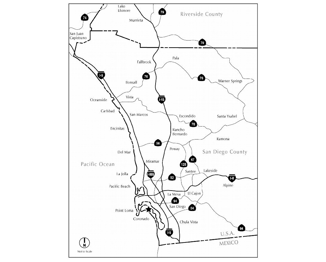
Figure I-1 Regional Setting
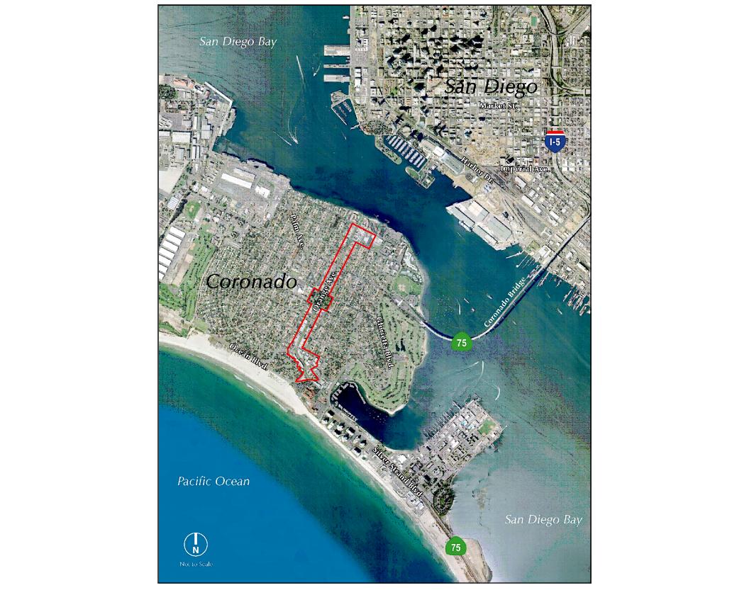
Figure I-2 Limited Vicinity Map
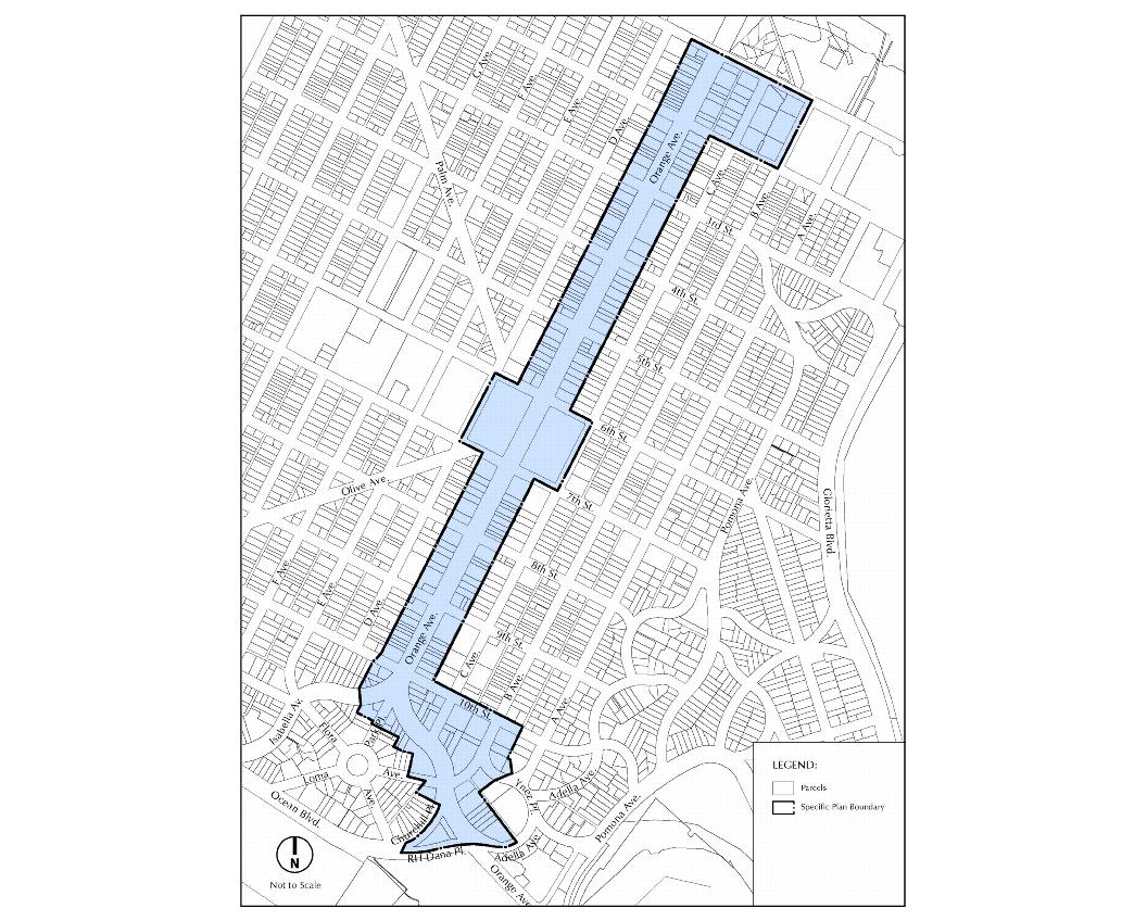
Figure I-3 Project Area Map
B. BACKGROUND
Coronado’s distinctive peninsular location and historic development have resulted in a community that is unique, intriguing and inviting. The development of Coronado dates to 1886 when Elisha S. Babcock and H.L. Story, the joint owners of the entire Coronado peninsula, formed the Coronado Beach Company, subdivided a portion of their holdings, cleared the land, graded streets and conducted Coronado’s first land auctions. The next year Babcock and Story built the Hotel Del Coronado with money generated by the land sales. In 1888 the Hotel Del opened for business, ushering in the tradition of luxury beachside resort hospitality, and in 1890 the City of Coronado was incorporated.
Coronado’s admirable physical environment, combined with the historic charm of the Hotel Del Coronado, has contributed to a destination resort and residential community. The wealth of many of Coronado’s early residents permitted commercial, civic and residential development of the quality that surpasses most cities of similar size. This strong architectural heritage is one of present-day Coronado’s defining characteristics. Moreover, the City’s strong tourist industry, combined with multiple naval installations, historically reinforced a strong, diverse commercial district. Due to compact urban design, commercial and civic facilities are easily accessible to pedestrians and bicyclists from most parts of the City.
Coronado’s citizenry and government responded to these trends in the community’s quality of life in several ways, including establishment of a Downtown Task Force and Coronado MainStreet Ltd., Orange Avenue Corridor Design Guidelines, revised parking and signage provisions in the Zoning Code, Unified Transportation Plan, Transportation Management Association and Business Area Development Plan. These efforts have resulted in the Downtown Streetscape project, median landscaping, preservation/restoration of the historic Spreckels Building, opening of the Lamb’s Players Theatre, and the Orange-Adella Enhancement Project. Other related planned projects include a new City Hall and recreation center along Glorietta Bay and the proposed Hotel Del Coronado expansion and improvement plans.
Downtown Coronado’s renaissance has been highly successful, as evidenced by the Year 2000 Great American MainStreet Award and the Year 2003 Dozen Distinctive Destinations Award from the National Trust for Historic Preservation. Some challenges still remain and new issues have arisen, including:
• Growing concern about the downtown evolving into a tourist-serving district, and the desire for expanded retail opportunities for residents
• Availability of convenient parking
• Continued expansion of discounted retail on North Island
• Ability of local businesses to compete with corporate establishments
• Recent closure of the City’s only movie theatre
• Prospect of increasing traffic volumes
• Need for improved aesthetic, land use, pedestrian/bicycle and vehicle connections
These challenges are either not addressed by existing planning documents, or the existing provisions are written as guidelines and lack implementation mechanisms.
In 2002, the City’s commitment to preserve and enhance Downtown Coronado continued with the City’s decision to develop a specific plan for the Orange Avenue Corridor.
C. LAND USE DESCRIPTION
The Orange Avenue Corridor project area includes four basic land uses – commercial (retail, restaurants, motels, office and services), multi-family residential, and civic / open space – which are described below and shown on Figure I-6, Generalized Existing Land Use.
C.1. Commercial
The commercial areas of the Orange Avenue Corridor contain primarily retail shops, restaurants, motels, offices, and personal and business services.
Commercial along the Orange Avenue Corridor is concentrated into two main areas, one that is north of Second Street and one that is south of Eighth Street. The intervening blocks from Second Street to Eighth Street are dominated by dense rental housing, condominiums, and small hotels/motels.
Uptown Commercial Area. The commercial area north of Second Street (Figure I-4) is primarily restaurant anchored, including eating and drinking establishments and an Albertsons grocery store. The north area’s retail mix includes approximately 39,000 SF of tourist-serving uses located at Coronado Ferry Landing, a tourist-oriented specialty retail center.
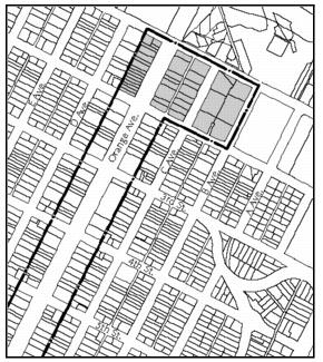
Figure I-4: Uptown Commercial Area
Although the Ferry Landing is outside the Specific Plan boundary, its size and proximity influence the Specific Plan area.
Within the Uptown commercial area, there are also some mixed use projects, with residential units above ground floor commercial uses.
Downtown Commercial Area. Most of the Plan area’s retail space is located along Orange Avenue, south of Eighth Street extending to the Hotel Del Coronado (Figure I-5.) The area is comprised of dense storefronts, generally narrow and deep in configuration, occupied by local-serving retail/commercial users. A Von’s grocery store and the vacant Village Theatre are located in the northern block of this area. The Downtown retail segment is dominated by the following categories:
|
• |
Eating Places |
|
• |
Personal Services |
|
• |
Business Services |
|
• |
Tourist Serving |
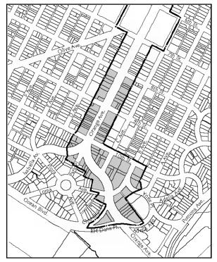
Figure I-5: Downtown Commercial Area
The true core of the Coronado’s retail market lies in the area between Tenth St. and the Hotel Del Coronado. This area is characterized by a curving streetscape accented by unique architecture with historic character. Small retail centers, totaling more than 94,000 square feet (SF) of retail space, are located on Orange Avenue between the southern terminus of C Avenue and the Hotel Del Coronado. The retail mix in the core is similar to that found throughout the remainder of the Orange Avenue corridor but introduces modest amounts of apparel, books, housewares, jewelry, and specialty retail shops.
The retail mix is slanted toward eating and drinking and business/personal service uses. Other retail categories are not well represented. Local residents appear willing to support business and personal service providers but exhibit price sensitivity on purchases of general merchandise and comparison goods, preferring to shop outside the City for these items.
Coronado’s approximately 60,000 SF of office space is concentrated in the extreme southern portion of the Downtown area, south of 10th Street. Slightly over 56,000 SF of office space is concentrated in three primary locations: California Plaza (33,000 SF), Coronado Plaza (9,500 SF), and El Dorado Square (13,800 SF.) Coronado’s office inventory also includes small amounts of second-story space that lacks amenities such as air conditioning, e.g., the Winchester Building and the Spreckels Building. There have been no new office buildings built in Coronado since the late 1970’s and early 1980s when California Plaza and El Dorado Square were constructed.
The City of Coronado is recognized as a world-class resort destination with the Hotel Del Coronado as its anchor, just outside the southern boundary of the Specific Plan area. Several of Coronado’s other lodging properties are located along Orange Avenue between Second and Eighth Streets, within the Specific Plan’s Multi-Family Residential area. The Downtown commercial area also has some hotels and motels, including La Avenida Inn and the El Cordova, which are within predominantly retail blocks.
C.2. Multi-Family Residential
The majority of housing stock within the Specific Plan area is concentrated between Second and Eighth Streets. It consists primarily of for-sale condominiums and rental properties in various multi-unit configurations, although there are some single-family detached units. Housing products vary widely with respect to age, style, density, and street orientation.
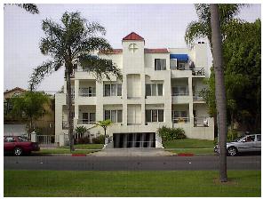
Photo 1: Condominium Building on Orange Ave
C.3. Civic and Open Space
On Orange Avenue between Sixth and Eighth Streets there are important civic and open space uses, including Spreckels Park, the Coronado Public Library, the Senior Citizens Center, and the City Police Department.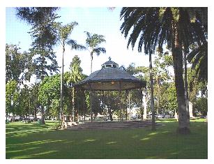
Photo 2: Spreckels Park

Photo 3: Coronado Public Library
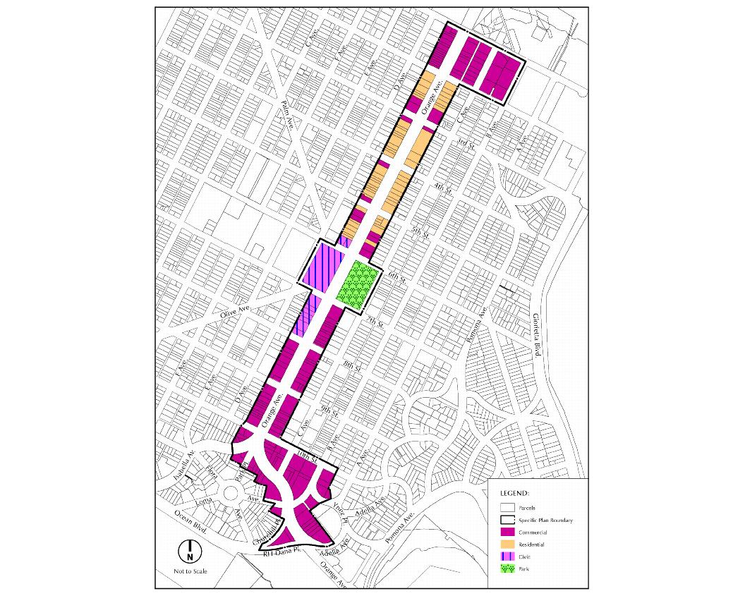
Figure I-6 Generalized Existing Land Use
D. PURPOSE AND INTENT OF THE SPECIFIC PLAN
The Orange Avenue Corridor Specific Plan provides a policy and regulatory bridge between the City of Coronado General Plan and individual, project-level development. The Orange Avenue Corridor Specific Plan includes policies that will serve as guidance to decision makers, and the regulatory development standards and design criteria intended to maintain Coronado’s “village” character. It also includes a number of non-regulatory recommendations to other bodies to address parking and mobility.
City staff, the Planning Commission and the Design Review Commission will use the Plan as part of the project review and evaluation process. The design criteria regulations inform property owners, developers, and design consultants as to what is required, expected and wanted for project design. Once adopted, the Orange Avenue Corridor Specific Plan’s regulations for zoning, development standards and design criteria, along with Municipal Code changes, will provide the legal development requirements for the Specific Plan area.
The Orange Avenue Corridor Specific Plan should not be considered an inflexible document. Rather, it has been developed to provide as much flexibility as allowed by State law. It should also be noted that this Specific Plan reflects a vision to be implemented over a 20-year period, and therefore, may be amended over time to reflect the City’s most current vision for the area.
E. ORGANIZATION OF THE SPECIFIC PLAN
The Orange Avenue Corridor Specific Plan contains various chapters that present background information; policy direction; and zoning, land use, and design criteria regulations. The Specific Plan is organized into ten chapters, as described below:
Chapter 1: Introduction
This Chapter provides an overview of the Orange Avenue Corridor Specific Plan, including intent and purpose of the plan, some background information and authority of the document.
Chapter 2: Planning Framework
This Chapter provides the policy foundation for the Specific Plan document. The Specific Plan planning framework describes public outreach activities, “Planning Factors”, and Specific Plan Goals and Objectives related to the development and implementation of the Orange Avenue Corridor Specific Plan.
Chapters 3, 4 and 5: Zoning Regulations
These Chapters respectively provide the general zoning provisions for all properties within the Specific Plan area; zoning regulations for the Commercial Zone; and zoning regulations for the R-4 Multiple Family Residential Zone.
Chapters 6 and 7: Design Criteria
Chapters 6 and 7 provide the regulatory design criteria for site planning, storefront design, buildings, landscape/hardscape, signs and public spaces that are applicable to properties within the Specific Plan area.
Chapter 8: Mobility, Wayfinding and Parking
This non-regulatory Chapter presents information on vehicular circulation, transit, bicycles, pedestrians, wayfinding and parking conditions within the Specific Plan area. It also includes recommendations directed to possible future conditions.
Chapter 9: Infrastructure
This non-regulatory Chapter summarizes the public utilities, infrastructure and services that are present and planned for the Specific Plan area. Specific services that are addressed include potable water, sewer, storm water drainage, and solid waste.
Chapter 10: Appendices
This Chapter provides background material related to the Specific Plan update process, including an analysis of General Plan consistency, a summary of the Market Analysis Report, a list of photograph locations, and a Glossary of Specific Plan terminology.
F. STATUTORY AUTHORITY OF THE SPECIFIC PLAN
The Orange Avenue Corridor Specific Plan is established through the authority granted to the City of Coronado by California Government Code, Title 7, Division 1, Chapter 3, Article 8, Sections 65450 through 65457 (specific plans).
As expressed in California law, Specific Plans may be adopted either by ordinance or by resolution. This allows jurisdictions to choose whether their specific plans will be policy driven (adopted by resolution) or regulatory in nature (adopted by ordinance). The Orange Avenue Corridor Specific Plan is a regulatory document that will be adopted by ordinance. The City’s Zoning Ordinance will provide supplemental zoning regulation where referenced by the Specific Plan.
As set forth in the Government Code, Section 65451, a Specific Plan must contain text and diagrams to address the following:
|
• |
The distribution, location and extent of the uses of land within the area covered by the plan. |
|
• |
The proposed distribution, location, extent and intensity of major components of public and private transportation, sewage, water, drainage, solid waste disposal, energy and other essential facilities proposed to be located within the area covered by the Specific Plan and needed to support the land uses described in the plan. |
|
• |
Standards and criteria by which development will proceed, and standards for the conservation, development and utilization of natural resources, where applicable. |
|
• |
A program of implementation measures, including regulations, programs, public works projects, and financing measures necessary to carry out the above information. |
|
• |
The Specific Plan shall include a statement of the relationship of the Specific Plan to the General Plan. |