


Chapter VIII
MOBILITY, WAYFINDING AND PARKING
A. INTRODUCTION
This chapter includes non-regulatory information on vehicular circulation, transit, bikeways, pedestrian walkways, wayfinding and parking.
B. VEHICULAR CIRCULATION
B.1. Existing Conditions
Automobiles are the primary means by which people access Coronado’s Downtown, and they will continue to be the primary mode in the foreseeable future. It should be relatively painless for someone to get to and from Coronado’s Downtown. Figure VIII-1 (see next page) shows the roadway classifications in Coronado within the Specific Plan area. Orange Avenue (designated as State Route 75 south of Third Street), along with Third and Fourth Streets are principal arterials, with four lanes of traffic. Orange Avenue north of Third Street is a minor arterial, while First Street, Sixth Street, Tenth Street and B Avenue are two lane collectors.
Traffic Flows. Figure VIII-2 portrays traffic flows along key roads downtown for the year 2000, as measured in “average daily trips” (ADT). Traffic flows are heaviest on Orange Avenue between Fourth Street and Tenth Street, and on Fourth Street from Orange Avenue to the Bridge, at slightly under 30,000 vehicle trips per day.
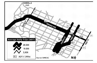
Figure VIII-2 Traffic Flows in Downtown Coronado for the Year 2000
Primary destinations for much of the commute traffic coming over the bridge are the North Island Naval Air Station and military facilities located further south, on the Strand. Major visitor destinations are the Hotel Del Coronado and the Downtown Commercial Zone (restaurants, shopping, and plays.)
B.2. Current Planning
Traffic congestion occurs in the blocks surrounding the intersection of the Third/Fourth Street couplets and Orange Avenue, and not only during commute hours. There are ongoing efforts by the City and Caltrans to address traffic issues on a city-wide scale, which would improve vehicular circulation within the Specific Plan area.
B.3. Recommendations
Improvements that can be made to traffic flows in the Downtown Coronado Specific Plan area relate primarily to efforts to reduce the number of auto trips on Orange Avenue. Two primary strategies are recommended:
Improved Parking. A better managed parking supply means that fewer autos would need to circle streets looking for a parking space.
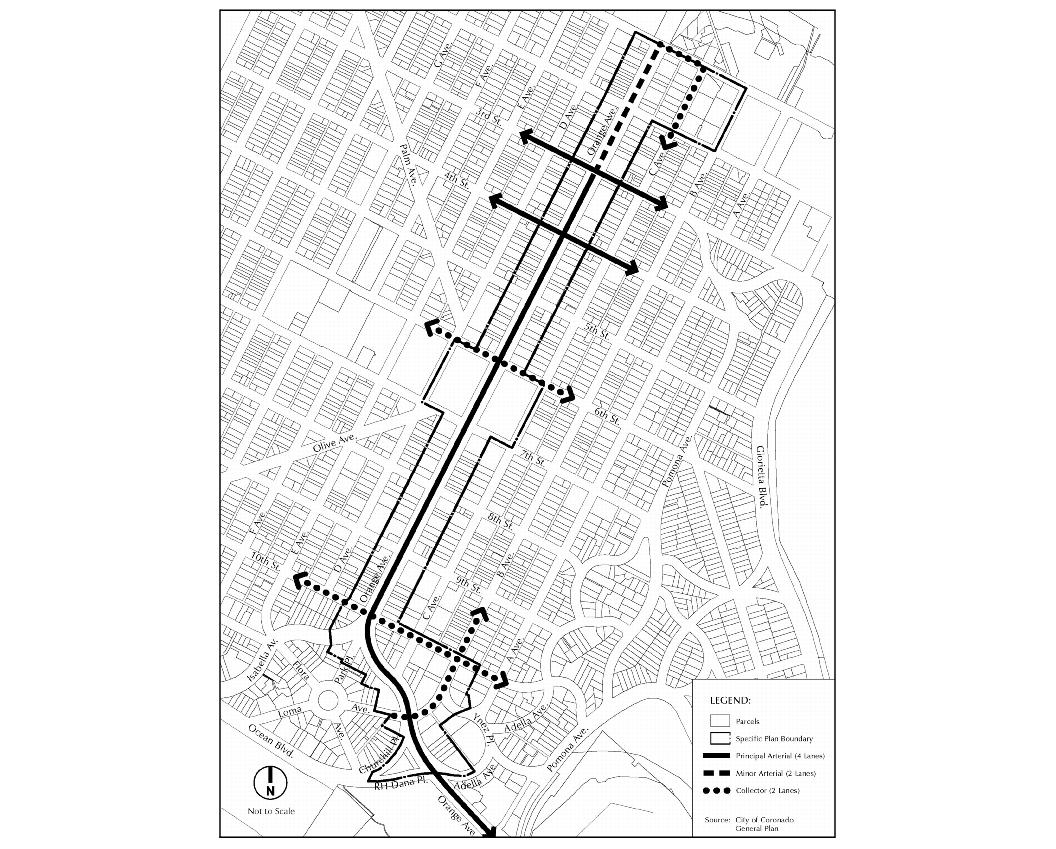
Figure VIII-1 Roadway Classifications
Improved Transit. Properly configured, operated, and designed, transit may be able to siphon off somewhere between 10 and 20 percent of traffic from Orange Avenue, according to initial ridership estimates prepared by SANDAG on the impact of MTDB’s long-range Transit First plan. Transit is further discussed in the next section.
C. TRANSIT
C.1. Transit Today
As shown in Figures VIII-3 and VIII-4, Coronado is currently served by four transit routes, operated under the direction of the Metropolitan Transit Development Board (MTDB): 901, 902, 903, and the Coronado Shuttle (Route 904). These routes connect Coronado to surrounding communities, as well as transfer points to other transit services.
For the most part, current transit routes serving Coronado may be characterized as slow and limited, serving primarily a transit-dependent population. In general, fewer than 1,500 people travel by transit along Orange Avenue on any given weekday (2001 data), with the majority of them traveling through Downtown Coronado to destinations on the other side of the Bridge or down the Silver Strand.
C.2. Transit Tomorrow
MTDB has proposed a number of improvements to the regional transit system, most notably through the Transit First Strategic Plan. The Transit First Plan proposes four kinds of transit services, color-coded as Yellow Car, Red Car, Blue Car, and Green Car. The existing trolley system is seen as a part of an expanded Red Car system, incorporating both light rail and “bus rapid transit” (BRT) components. Red Car service is corridor-focused, much like the existing trolley system, traveling at speeds of 15 to 30 mph, with stations spaced approximately every mile.
SANDAG’s Regional Transportation Plan includes a proposed “Red Car” line connecting Coronado to Downtown San Diego, Hillcrest, and University Town Center. This line will operate similar to MTDB’s existing trolley but will use rubber-tired vehicles that resemble a cross between a bus and a trolley car. “Flex-Trolleys” are expected to enjoy priority treatment on roads.
C.3. Recommendations
It should be a goal of the City to encourage visitors to use transit to access Coronado, where such transit can actually meet the needs of these persons, whether visitors, local business employees, or local military installation personnel and employees. Increased transit use decreases auto trips, reducing the pressure on parking, road congestion, and overall traffic.
Efforts should be made to ensure that future transit lines in Coronado connect appropriate areas both within and outside Coronado; that transit routes are outfitted with signal-priority systems and other means to speed services to their maximum safe potential; and that customer convenience and comfort is considered.
See The Mission Group’s 2002 report, “Mobility Plan for Downtown Coronado Specific Plan” for more detail.
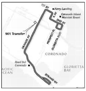
Figure VIII-3 The Coronado Shuttle (Route 904) operates hourly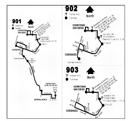
Figure VIII-4 – Existing transit routes serving Coronado. The 901 is an all-day service (15 minute frequency peak period, 30 minute frequency off-peak); whereas the 902 and 903 only operate during peak hours.
D. BICYCLING/PEDESTRIAN CIRCULATION
D.1. Existing Conditions
Coronado is a city well suited for bicycling. The traditional street grid pattern, relatively wide streets, attractive streetscapes, abundant landscaping, mild climate, and relatively flat elevations combine with the many sights of Coronado to create one of the most attractive bicycling environments found in any city. The street grid’s high degree of connectivity gives cyclists a choice of routes and the ability to easily reach most city destinations. The wide streets, which operate at generally low traffic volumes (outside of Orange Avenue and the Third Street/Fourth Street couplets) create “safe zones” for cyclists, who may be passed safely by cars. The variety of architecture, landscaping, and scenic views make cycling in Coronado a visual pleasure and an interesting experience.
In general, traffic is not a major impediment to cyclists, except on Orange Avenue and on the Third/Fourth Street couplets (or getting across those couplets). Just the same, there is little to be recommended for improving bicycle travel to/from the Downtown. Outside of special pathways such as the Silver Strand bike path, the safest place for cyclists is on the road. The use of alleyways as alternative routes for bicyclists is generally not recommended, due to a heightened risk of accidents. Most motorists do not expect cyclists to emerge from alleyways and cross over or merge with traffic.
D.2. Bicycle Racks
The real issue facing cyclists accessing Coronado’s Downtown is where to safely leave their bicycles while they take advantage of shopping, dining, entertainment, or even employment opportunities. Since bicycles can bring riders closer to their destination than a car could, most cyclists expect to find bicycle parking closer to their destination than a car driver would in searching for parking.
Bicycle racks should be provided throughout the commercial areas, located in appropriate well-illuminated places to reduce the possibility of theft or vandalism but not obstruct pedestrian activity.
D.3. Pedestrian Walkways
Coronado is one of the most pedestrian-friendly cities in all of Southern California, and its Downtown is generally very accommodating to pedestrians. Sidewalks are wide, storefronts are mostly continuous and interesting, and attractive landscaping enlivens the experience. It is a short, “easy” walk -- approximately 10 to 15 minutes on level surfaces -- from much of Coronado to the commercial areas along and near Orange Avenue.
Potential future implementation strategies to further enhance the pedestrian environment include:
Expansion of Rotary Park. Located at the intersection of Orange Avenue with Isabella Avenue, Tenth Street, and Park Place, this is the “hinge point” of Downtown Coronado, where Orange Avenue turns to the southeast. Unfortunately, the streetscape edge on the western side of Orange Avenue breaks down at this key point, where inappropriately sited buildings create more of an “auto zone” than a pedestrian-scaled zone. Perceived distances on this segment of Orange Avenue are exaggerated, which affects pedestrians’ decision to continue walking or to turn back. It also influences the pedestrian’s feeling of safety, as they must interact with cars crossing from many streets and parking lots, and therefore need to exercise a higher degree of caution.
A redesigned western edge of Orange Avenue, between Tenth Street and Park Place, would significantly improve the pedestrian experience and increase their willingness to walk a little further to get from parking to their Orange Avenue destination.
Alleys. Limit pedestrian circulation in the alleys because most alleys run parallel to Orange Avenue, offering little in the way of “short cuts” between any given points; and the alleys generally serve vehicular uses quite well. Employee, residential, and limited customer parking, in addition to commercial loading, all take advantage of this resource. The alleys permit Orange Avenue’s Commercial Zone to be generally free of the curb cuts, garage entrances, and other disruptions to streetscape and sidewalk that mar many other cities’ downtown areas. Because most sidewalks in Downtown Coronado are well-designed, pedestrian friendly, and conveniently located (most buildings open onto the sidewalk, not a rear parking lot), there is no real desire, need, or incentive for most pedestrians to use the alleys.
E. WAYFINDING
E.1. Introduction
Wayfinding refers to a system of design features (e.g., signs, lighting, landmarks, directories) used to both help people orient themselves and navigate between places. Once viewed as a navigational aid, “wayfinding” systems now are seen as a way to market an area’s resources, alter negative perceptions, evoke a sense of downtown history and character, and improve the streetscape.
For years, well-designed wayfinding systems have been used by indoor malls, airports, and corporate campuses. Now these environmental graphics are being used increasingly often by traditional downtown commercial areas. People make qualitative assessments about a place based upon how well-designed and understandable it is to find where they need to go.
Currently, the only wayfinding in the Specific Plan area is CalTrans’ standard green and white signs and occasional California State historical site signs. A well thought out wayfinding system will orient visitors to Coronado by pointing out attractions, adding historical explanations, directing vehicles to parking facilities for specific activities, and locating amenities.
The vehicular traveler approaching Coronado over the Bridge is greeted by a simple yet elegant classic-design entry sign located on the left side of the road. While the sign is well- designed, due to its location on an inside curve it can be easily overlooked by arriving visitors. The City may want to re-locate the sign to a more visible location at some future time.
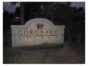
Photo 72: Entry Sign on Third Avenue
Arriving at Orange Avenue, one sees a California historical marker for the Hotel Del Coronado and Caltrans’ generic green “business district” sign directing travelers both north and south on Orange Avenue. Orange Avenue’s signature landscaped medians provide a strong sense of identification for the Orange Avenue corridor and the Downtown area. The visual impact of the northern median end, although less than in the south, was enhanced by additional landscaping (in 2003) that helps to create a stronger entry statement.
E.2. Directional Signage
Visitors approaching downtown’s commercial areas will need easily recognizable directional signs to help them locate important destinations. It is very important that these signs are:
• Graphically interesting
• Unique public signage
• Used in the Commercial Zone only
It is recommended that all new public wayfinding signs incorporate a custom designed “downtown” logo (by separate graphic artist) over a field of color and a crisp, non-italicized lettering style.
There are several City locations that visitors and residents could be directed to. Some of these locations are outside the Orange Avenue Corridor; however, it is very important to link the commercial areas with these attractions/locations. While it is not practical as part of the Specific Plan to list every single place that could be identified on directional signs, the following are considered excellent candidates:
|
• |
City Hall |
|
• |
Library |
|
• |
Police Station |
|
• |
Post Office |
|
• |
Marina |
|
• |
Spreckels Park |
|
• |
Ferry Landing |
|
• |
Rotary Park (after expansion) |
|
• |
Hotel Del Coronado |
|
• |
History Museum |
|
• |
Public Beach |
|
• |
Uptown & Downtown Commercial Area |
The graphic example shown in Figure VIII-5 is for illustration concept purposes only. It is recommended that these images be refined further or that a new distinctive public signage program be developed for the Orange Avenue Corridor.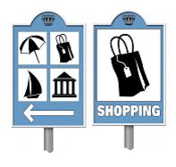
Figure VIII-5 Conceptual Directional Signage
Businesses located on less traveled side streets have less exposure to pedestrian and vehicular traffic than do businesses on Orange Avenue. Directional signage for side street businesses is allowed but must congregate in a single location, such as a street corner. The directional signage should be designed as public art, compatible with its surroundings, and contribute to the overall pedestrian environment.
E.3. Parking Signage
Various activities in Coronado are served by different parking areas, e.g., shopping in the Downtown commercial area or going to the beach. Parking signage that both directs users to parking areas and indicates the nearby activity helps users to park in the most convenient location for their purpose. See Figure VIII-6 for an example.
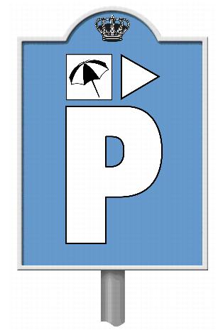
Figure VIII-6 Conceptual Beach Parking Signage
E.4. Street Signage
A unique street sign should be created and installed for all street corners within the Specific Plan area. This helps create an identity and sense of place that is distinct from the rest of Coronado. Figure VIII-7 is a conceptual design for such signage.
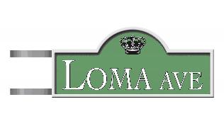
Figure VIII-7 Conceptual Street Signage
E.5. Kiosk Program
The previous sections focused on vehicular signage; however, once people are out on foot, a system of pedestrian informational kiosks is desirable for orientation and to stimulate interest in walking further. The kiosks would display a key map with various destinations (see list above.) Kiosk design should be compatible with the character of the Specific Plan’s commercial areas.
For planning purposes, the following locations are recommended for kiosk locations:
|
• |
Downtown commercial area in near proximity to Hotel Del Coronado and/or Adella Plaza |
|
• |
Rotary Park (after expansion) |
|
• |
Uptown commercial area near the Ferry Landing |
F. PARKING
The Mission Group prepared a parking study as part of the Orange Avenue Corridor Specific Plan process. While portions of the study are summarized below, the full document is available at City of Coronado’s Community Development Department.
The parking study looked at conditions in the commercial areas within the Specific Plan area and some residential blocks outside of the Specific Plan area, but adjacent to it. The parking study’s area encompasses Coronado’s northern and southern commercial centers, and included 20 blocks of off-street parking and 85 block faces of on-street parking (See Figure VIII-8).
For the purposes of the study, the larger area was divided into three sub-areas (See Figure VIII-9).
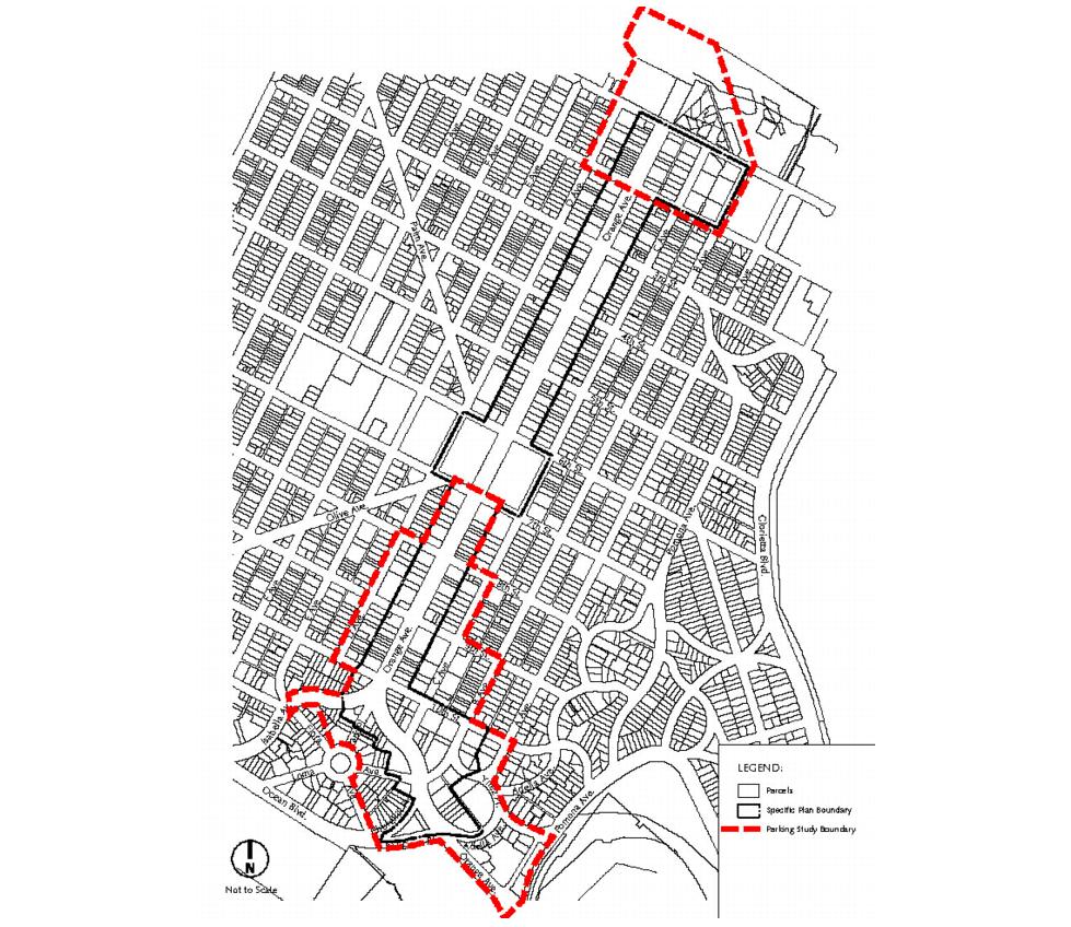
Figure VIII-8 Parking Study Area
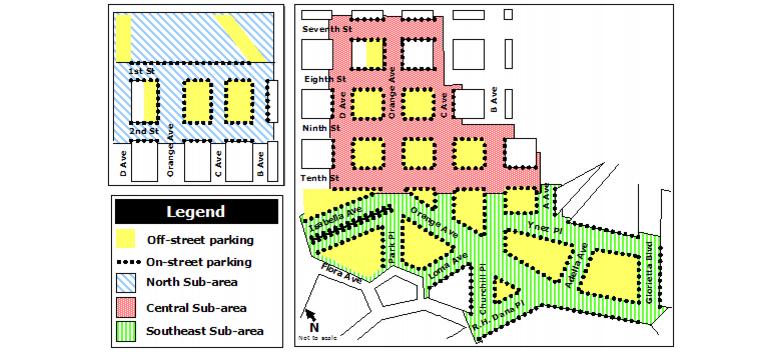
Figure VIII-9 Parking Study Sub-areas
F.1. Existing Parking Conditions
On-Street Parking. There are 1,269 on-street parking spaces available within the study area before 6:00 pm. Forty percent (505 spaces) are metered and 60 percent (764 spaces) are non-metered. An additional 39 non-metered spaces are available only after 6:00 pm, when commercial loading zone spaces become available for public parking. Figure VIII-10 shows the total on-street parking spaces available before 6:00 pm. Segment totals are for block sides that face each other, e.g., the east and west side of Orange Avenue between First and Second streets.
Twelve percent (157 spaces) of all on-street parking spaces are located on Isabella Avenue. Fourteen percent (183 spaces) of all on-street parking spaces are located along Orange Avenue. Twelve percent of metered spaces are located on Isabella Avenue. One-third of all metered spaces are within one block of the intersection of Orange Avenue and Tenth Street.
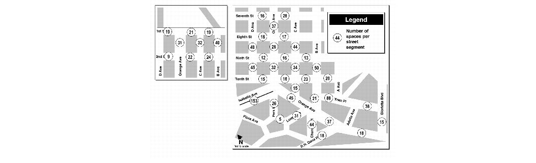
Figure VIII-10 On-Street Parking Inventory Before 6 PM
Off-Street Parking. Within the study area there are 1,432 total off-street parking spaces available to customers and employees of commercial uses (Figure VIII-11). Of these, 204 spaces are in lots with limited hours. These lots include the Bank of America parking garage (block 13), an office lot (block 14), and a commercial lot (block 13). On weekdays, these lots are not available to the general public after 6:00 pm. On weekends, 92 of the spaces are not available at all (office lot in block 14), 99 are not available after 3:00 pm (Bank of America garage) and 13 are not available after 6:00 pm (commercial lot in block 13). Figure VIII-11 shows the off-street parking spaces for each block within the study area.
Figure VIII-11 Off-Street Parking Spaces
Table VIII-1 shows on- and off-street parking spaces within a subset of the study area; Figure VIII-12 shows the Block ID numbers referred to in the table.
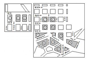
Figure VIII-12 Block ID numbers
|
Table VIII-1 – Off-Street Parking Spaces* |
|||
|---|---|---|---|
|
Block ID |
Existing Off-Street Parking Spaces* |
Existing On-Street Parking Spaces |
Total Parking Spaces |
|
2 |
57 |
31 |
88 |
|
3 |
75 |
46 |
121 |
|
4 |
185 |
54 |
239 |
|
7 |
117 |
29 |
146 |
|
8 |
46 |
29 |
75 |
|
9 |
68 |
30 |
98 |
|
10 |
83 |
33 |
116 |
|
11 |
14 |
87 |
101 |
|
12 |
6 |
29 |
35 |
|
13 |
177 |
35 |
212 |
|
16 |
98 |
55 |
153 |
|
18 |
91 |
40 |
131 |
|
19 |
26 |
85 |
111 |
|
20 |
15 |
80 |
95 |
|
21 |
0 |
38 |
38 |
|
TOTAL |
1,058 |
701 |
1,759 |
* Does not include entire parking study area.
F.2. Parking Utilization
Parking utilization gives the proportion of cars parked compared to the total number of parking spaces available in a specified area. On-street parking is generally considered “optimal” when 85 percent of the available parking spaces are occupied at any given time. This rate ensures that a parking space is almost always available for arriving cars, but that all other spaces are occupied. Once utilization exceeds 85 percent, parking becomes progressively more difficult to find. Areas can exceed 100 percent utilization when multiple vehicles are parked in a space intended to fit only one car, when vehicles are parked illegally, or when vehicles are double-parked.
During weekdays, on-street parking in the study area is consistently heavy, with the highest overall demand at lunchtime (81 percent of spaces occupied) and the lowest between 5:00 pm and 6:00 pm (66 percent of spaces occupied).
Overall, parking is impacted in the commercial core of Coronado, but the extent was rarely severe during the periods surveyed. For example, although parking along most street segments in the Southeast sub-area were fully or over-subscribed, parking was still available along nearby streets.
On weekends, overall demand for on-street parking is even more constant than on weekdays, with a tight range of 68-76 percent utilization. Parking utilization in the Southeast sub-area is highest, especially for the two meal-time periods: 12:00 – 2:00 pm and 6:00 – 8:00 pm.
F.3. Future Demand
Coronado’s commercial areas are virtually “built out” but some redevelopment of underutilized lots, expansion of existing businesses, or tenant changes are likely to occur, resulting in the need for more parking. Keyser Marston’s Market Study for Downtown Coronado (June 2002) notes that the type of businesses with the strongest potential to succeed include restaurants, one-of-a-kind specialty retailers, upscale boutique retailers, and specialty food outlets.
The additional parking demand that would be generated by any new development or redevelopment will be subject to the parking requirements of this Specific Plan.
Factors which contribute to Coronado’s parking situation are:
a. Downtown Coronado’s relatively small storefronts, combined with its pedestrian-friendly character, effectively create an environment where people park in one place and patronize several businesses within a couple blocks instead of parking separately for each destination.
b. Different commercial uses have different peak demand times, such as offices from 8:00 am to 5:00 pm, restaurants during lunch, and the live theater during the evening. Because of this, peak demand is spread out throughout the day, instead of occurring at one time.
F.4. Parking Recommendations
The study of parking utilization in Coronado confirms that much of the commercial core of this city is “parking impacted,” meaning that demand outstrips supply. The situation is especially pronounced in the Central and Southeast sub-areas, with the Southeast portion showing the greatest demand during the day as well as additional evening impacts. The North section is also impacted, but in a much more concentrated manner, with parking always available near impacted areas. Given the nature of potential development/ redevelopment in each of the three sub-areas, the following strategies are recommended for ensuring minimal parking impacts:
a. Encourage large developments in the Specific Plan area to provide more off-street parking than is required.
b. As a short-term strategy to increase parking in the Southeast sub-area, explore options to lease or assume liability for public parking in existing private facilities during those hours for which those facilities are closed.
c. Ensure that an adequate number of metered spaces on Orange Avenue are designated for relatively short-term parking (30 minutes or one hour maximum), in order to best support resident access to local businesses.
d. Revise the Parking Ordinance so that parking requirements are based solely on square footage; parking requirements based on number of employees or number of seats should be eliminated.