


Chapter 17.53
HILLSIDE AND RIDGELINE DEVELOPMENT
Sections:
17.53.030 Permit requirements.
17.53.040 Hillside subdivision standards.
17.53.050 Site planning and development standards.
17.53.060 Building design standards.
17.53.070 Hillside development permit.
17.53.010 Purpose.
The provisions of this chapter are intended to:
A. Preserve the city’s environmental and scenic resources by encouraging the retention of natural topographic features and vegetation;
B. Recognize that as the slope of a development site increases so does the potential for environmental degradation including slope failure, and increased storm water runoff that will also increase the potential for erosion, and waterway sedimentation;
C. Encourage grading practices that are appropriate in hillside areas; and
D. Encourage structures on hillside parcels to be designed with scale, massing, architectural design and detailing appropriate to maintain the visual character of hillsides as natural and open. (Ord. 766 § 2 Exh. A (part), 2004).
17.53.020 Applicability.
A. Applicability of Chapter. The requirements and guidelines in this chapter apply to subdivisions, and all other proposed development or a new land use on a site with a slope of ten percent or greater on any portion of the site.
B. Limitation on Hillside Development. No new grading or other construction shall occur on a slope of more than fifteen percent, except:
1. Where the commission determines through the review of a hillside development permit application that there is no alternative building site available on an existing parcel with a slope of fifteen percent or less; and
2. In no case shall grading or construction occur on a slope of twenty percent or more, unless this limitation would result in an unconstitutional taking of private property without just compensation.
In granting an exception in compliance with this section, the commission shall ensure that the proposed project complies with all other standards of this chapter to the maximum extent feasible.
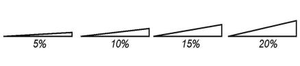
Figure 5-3. Illustration of Slope
(Ord. 766 § 2 Exh. A (part), 2004).
17.53.030 Permit requirements.
A proposed project that is subject to this chapter shall be authorized by a hillside development permit in compliance with Section 17.53.070 (Hillside development permit) of this chapter, in addition to any other permit required by this land use code. (Ord. 766 § 2 Exh. A (part), 2004).
17.53.040 Hillside subdivision standards.
A proposed subdivision shall comply with the following standards:
A. Parcel and Building Site Slope. No parcel shall be created:
1. With an overall average slope of twenty percent or more; or
2. Without at least one building site of at least five thousand square feet that has no slope of ten percent or more, and that will allow a house to be constructed in compliance with all other applicable provisions of this chapter.
B. Roads. Each new road shall follow natural terrain contours to the maximum extent feasible to minimize grading, and shall comply with the standards for hillside roadways in Chapter 17.26 (Street and Streetscape Standards) of this title. Proposed driveways shall comply with the requirements of Section 17.53.050 (Site planning and development standards) of this chapter. (Ord. 766 § 2 Exh. A (part), 2004).
17.53.050 Site planning and development standards.
Each structure shall be located in the most accessible, least visually prominent, most geologically stable, portion or portions of the site, and at the lowest feasible elevation. Structures shall also be aligned with the natural contours of the site. Siting structures in the least prominent locations is especially important on open hillsides where the high visibility of construction should be minimized by placing structures so that they will be screened by existing vegetation, depressions in topography, or other natural features.
A. Site Access. Each driveway shall follow natural terrain contours to minimize grading, and also shall comply with the following standards:
1. Common driveways that serve more than one parcel are encouraged, and may be required, to reduce the total amount of grading and pavement.
2. Drainage from a driveway shall be directed in a controlled manner to the drainage facilities of the nearest road, subject to the approval of the city engineer.
3. A driveway shall not have a grade steeper than five percent within ten feet of a garage or carport entry. Driveway finished grade shall not exceed an average of fifteen percent.
B. Site Coverage. Total site coverage by structures and other nonpermeable surfaces shall not exceed thirty percent of the areas of the parcel with a slope of less than fifteen percent, and zero percent of the areas with slopes in excess of fifteen percent.
C. Setbacks. A proposed structure shall comply with the following setback requirements instead of the requirements of the applicable zoning district, to locate buildings as close as possible to streets, encourage compact development, and thereby minimize the disruption of natural features. See also the limitations on the allowable uses of setbacks in Section 17.30.020 (Build-to-lines and setbacks) of this title.
|
Property Setback |
Setback Distance |
|---|---|
|
Front |
10 ft. |
|
Side |
10% of parcel width, with a minimum of 10 ft. and a maximum required setback of 15 ft., except as provided in Section 17.53.050(D). |
|
Street Side |
10% of parcel width, with a minimum of 10 ft., and a maximum required setback of 15 ft. |
|
Rear |
30 ft., except as provided in Section 17.53.050(D). |
|
Ridgeline(1) |
50 vertical feet from ridgeline. See also Section 17.53.050(E) and Figure 5-4. |
Notes:
(1) A new structure or addition is prohibited within fifty vertical feet of a ridgeline unless this restriction completely precludes development of the property. An exception may be granted if the review authority first finds that:
a. There are no feasible building sites on the parcel that avoid ridgeline development;
b. In the case of a subdivision, the density has been reduced to the minimum standards consistent with the general plan density range;
c. No new subdivision of parcels is created that will result in ridgeline development; and
d. The development will avoid significant adverse visual impacts due to modifications in structural design including height, bulk, size, foundation, siting, and landscaping.
D. Side and Rear Setback from Slope. Where a building site abuts a parcel with an elevation that is three feet or more above or below that of the site, the required side and/or rear yard shall be measured from the nearest toe or top of slope to the structure, whichever is closer. See Figure 5-4.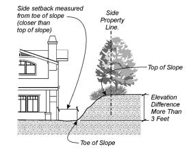
Figure 5-4. Side Setback Measurement
E. Height Limits. Each proposed structure shall comply with the following height limits, instead of the height limit of the applicable zoning district:
1. Height Measurement. The maximum allowable height shall be measured as the vertical distance from the natural grade of the site to an imaginary plane located the allowed number of feet above and parallel to the grade. See Figure 5-5.
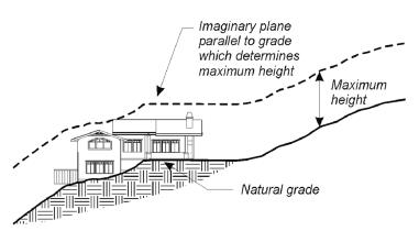
Figure 5-5. Height Measurement on Hillsides
2. General Height Limit. No structure shall exceed a height of twenty-four feet, measured in compliance with subsection (E)(1) of this section, and shall not exceed a height of thirty-five feet, measured from the lowest elevation on the site where the structure touches the grade, to the highest point of the roof. See Figure 5-6.
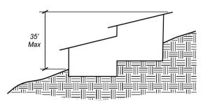
Figure 5-6. Maximum Height on Sloping Site
3. Placement of Structures. Proposed structures shall comply with the following standards, to maintain the natural appearance of hillsides and ridgelines:
a. Each structure shall be located as follows; provided that the review authority may modify or waive these standards where it determines that a structure on the only feasible building site of an existing parcel cannot comply.
i. No part of a proposed structure shall appear silhouetted against the sky above the nearest ridge or knoll when viewed from a public street. See Figure 5-7.
ii. The topmost point of a proposed structure and all site grading shall be at least thirty feet below the top of the nearest ridge or knoll. See Figure 5-8.
b. Each structure shall be located to take advantage of existing vegetation for screening, and should include the installation of additional native plant materials to augment existing vegetation, where appropriate.
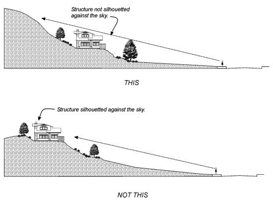
Figure 5-7. Silhouetted Structure
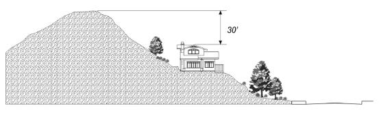
Figure 5-8. Location of Structure Below Ridgeline
4. Height Limit Above Ridgeline. Where the review authority determines that a legal lot existing prior to the effective date of the ordinance codified in this section contains no feasible building site other than where a structure will extend above the ridgeline, proposed structures shall not exceed a height of sixteen feet above the highest point on the ridgeline or hilltop within one hundred feet of the proposed structure. See Figure 5-9.
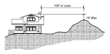
Figure 5-9. Highest Point Within One Hundred Feet of Structure
5. Height of Lowest Floor Level. The vertical distance between the lowest point where the foundation meets grade and the lowest floor line of the structure shall not exceed six feet (see Figure 5-10).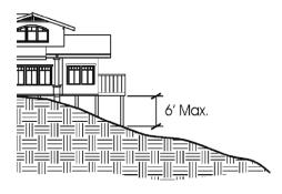
Figure 5-10. Height Limit for Lowest Floor and Decks
6. Downhill Building Walls. No single building wall on the downhill side of a house shall exceed fifteen feet in height above grade. Additional building height on a downhill side may be allowed in fifteen-foot increments, where each increment is stepped-back from the lower wall a minimum of ten feet (see Figure 5-11).
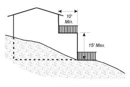
Figure 5-11. Height Limit for Downhill Building Walls
7. Decks. No portion of the walking surface of a deck with visible underpinnings shall exceed a height of six feet above grade. Decks shall be integrated into the architecture of the house, not appearing as an “add-on” to the primary building mass (see Figure 5-10).
F. View Protection. A proposed structure shall be designed and located so that it avoids blocking views from other properties to the maximum extent feasible, as follows. See Figure 5-12.
1. New structures and tall landscaping shall not be placed directly in the view of the primary living areas on a neighboring parcel.
2. Mechanical equipment may be placed on rooftops or below a deck only if the equipment is not visible from off the site, except for unobtrusive solar collectors that are compatible with the roof line and architecturally integrated with the structure. This equipment shall also comply with the height limits in subsection (E)(2) of this section.
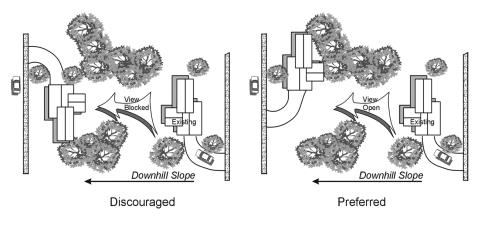
Figure 5-12. View Protection
G. Exterior Lighting. Exterior lighting shall be shielded to avoid glare and the spill of light to surrounding areas. Low-level lighting and multiple low-profile fixtures are encouraged, as opposed to the use of fewer, taller fixtures.
H. Retaining Walls. An embankment to be retained that is over forty-eight inches in height shall be benched so that no individual retaining wall is higher than thirty-six inches, and each bench is a minimum width of thirty-six inches. See Figure 5-13.
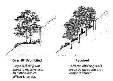
Figure 5-13. Retaining Wall Design
(Ord. 766 § 2 Exh. A (part), 2004).
17.53.060 Building design standards.
Building and site design shall generally utilize varying setbacks and structure heights, split-level foundations, and low retaining walls to blend structures into the terrain. See Figure 5-14.
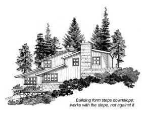
Figure 5-14. Design Sensitive to Terrain
(an example of building form, not intended to show preferred architectural style)
A. Maximum Floor Area. The gross floor area of all structures on a parcel shall not exceed thirty percent of the areas of the parcel with a slope of less than fifteen percent, and zero percent of the areas with slopes in excess of fifteen percent.
B. Windows. Windows, balconies, and outdoor living areas generally shall be located to protect the privacy of adjacent homes and yards. Windows visible from off the site shall be glazed with nonglare glass.
C. Exterior Wall Surfaces. The apparent size of exterior wall surfaces visible from off the site shall be minimized through the use of single-story elements, setbacks, overhangs, roof pitches, landscaping, and/or other means of horizontal and vertical articulation to create changing shadow lines and break up massive forms.
D. Colors and Materials. A mixture of materials and color shall be used to blend structures with the natural appearance of the hillside:
1. Based upon the graphic principle that darker colors are less noticeable than light colors, darker tones, including earth tones shall generally be used for building walls and roofs on highly visible sites so that buildings appear to blend in with the natural terrain.
2. Exterior finish materials shall be appropriate for the architectural style of the structure and compatible with the hillside environment.
E. Roofs. Roof pitches shall generally be placed to follow the angle of the slope; but with variations to avoid a monotonous appearance. See Figure 5-14.
F. Support Structures. Support structures (for example, columns, pilings, etc.) below the lowest floor on the downhill side of a house, shall be enclosed unless visible structural members are an integral feature of the architectural design. Support structure wall surfaces shall not exceed six feet in height.
G. Landscaping. See Chapter 17.34 (Landscaping Standards) of this title. (Ord. 766 § 2 Exh. A (part), 2004).
17.53.070 Hillside development permit.
A. Purpose. The hillside development permit provides a review process for the city to consider the appropriateness of proposed development on hillside parcels, to ensure that a proposed project minimizes its visual and environmental impact.
B. Applicability. A hillside development permit is required to authorize any proposed development that is subject to the requirements of this chapter.
C. Application Filing and Processing. An application for a hillside development permit shall be filed and processed in compliance with Chapter 17.60 (Permit Application Filing and Processing) of this title. A hillside development permit application shall include all information and materials required by Section 17.60.040 (Application preparation and filing), and the following additional information:
1. Site Topography. A topographic map covering the entire site, and areas on surrounding parcels within fifty feet of the site boundary. The topographic map shall be prepared with a contour interval of two feet, which shall also identify the proposed building site, and all areas of the site with slopes of ten percent or less, all areas of the site with slopes that are more than ten percent but no more than fifteen percent, all areas of the site slopes that are more than fifteen percent but less than twenty percent, and all areas of the site with slopes of twenty percent or more.
2. Geotechnical Report. A preliminary geotechnical report that identifies and proposes mitigation measures for any soils or geological problems that may affect site stability or structural integrity. Depending upon the site characteristics and project design, the review authority may also require a final geotechnical report.
3. Constraints Analysis. For properties determined by the director to potentially have sensitive environmental resources including endangered plants or animals, or a wildlife corridor, a qualified professional approved by the director shall prepare a site constraints analysis. The report shall include proposed mitigation measures to effectively protect identified important biological features.
D. Review Authority.
1. Commission Approval. The following shall require the approval of a hillside development permit by the commission:
a. Subdivision. A proposed subdivision shall require a hillside development permit in addition to the approval of a tentative map, and parcel map or final map in compliance with Article 7 (Subdivisions) of this title.
b. Single Dwelling. The construction of one dwelling on an existing parcel; or an addition to an existing dwelling that increases its floor area by twenty-five percent or more.
c. Multiple Dwellings. The construction of two or more dwellings in the same subdivision by the same developer.
2. Director Approval – Addition to Single Dwelling. The director may approve a hillside development permit for an addition to an existing dwelling that increases floor area up to twenty-five percent, or may refer the matter to the commission for a decision. An addition that increases floor area by twenty-five percent or more requires commission approval.
E. Project Review, Notice, and Hearing. Each application shall be analyzed by the director to ensure that the application is consistent with the purpose and intent of this section. Where subsection (D)(1) of this section requires that a hillside development permit application be considered by the commission:
1. The director shall submit a staff report and recommendation to the commission;
2. The commission shall conduct a public hearing on an application for a hillside development permit prior to the approval or disapproval of the permit; and
3. Notice of the public hearing shall be provided, and the hearing shall be conducted in compliance with Chapter 17.88 (Public Hearings) of this title.
F. Findings and Decision. The review authority may approve, conditionally approve, or disapprove a hillside development permit application, and shall record the decision and the findings upon which the decision is based. The review authority may approve the permit only after first finding that:
1. The proposed project complies with the requirements of this chapter and all other applicable provisions of this land use code;
2. The proposed project is consistent with the general plan and any applicable specific plan;
3. The design, location, and size of proposed structures and/or additions or alterations to existing structures will be compatible with adjacent existing and anticipated future development, in terms of aesthetics, character, scale, and view protection;
4. The design and placement of proposed structures will minimize their visibility from off the site and reinforce the appearance of the site as more of an open hillside than an intensively developed property, to the maximum extent feasible; and
5. The placement of proposed structures on the site avoids slopes over ten percent to the maximum extent feasible.
G. Adjustments to Standards. The review authority may grant an adjustment to the standards of this chapter as part of hillside development permit approval only where it first finds that:
1. The adjustment is either necessary to allow a house with reasonable floor area on a site with excessive slope or other environmental constraints; or
2. The adjustment will result in less visual impact than would development in compliance with the standard being adjusted.
H. Conditions of Approval. In approving a hillside development permit, the review authority may impose any conditions it deems reasonable and necessary to ensure that the approval will comply with the findings required by subsection F of this section.
I. Post Approval Procedures. The procedures and requirements in Chapter 17.64 (Permit Implementation, Time Limits, and Extensions), and those related to appeals in Chapter 17.84 (Appeals) of this title, shall apply following the decision on a hillside development permit. (Ord. 766 § 2 Exh. A (part), 2004).