


SECTION 25.51
MEASUREMENTS
Sections:
25.51.6 Measuring Building Transparency
25.51.1 Purpose
This Section explains how to calculate results and determine various measurements referenced in this Zoning Ordinance.
25.51.2 Rounding Fractions
When calculations result in a fraction, the result shall be rounded to the next whole number according to this Section. Setback distances are stated as absolute values and will in no case be rounded to the next whole number.
A. Minimum requirements. When a regulation is expressed in terms of a minimum requirement, any fractional result will be rounded up to the next consecutive whole number. For example, if a minimum requirement for one street tree for every 40 feet is applied to a 100 foot strip, the resulting fraction of 2.5 is rounded up to three required trees.
B. Maximum requirements. When a regulation is expressed in terms of maximum limits, any fractional result lower than .49 will be down to the next lower whole number. For example, if a maximum height for a building is 35 feet and the building actually measures 35 ’-5", then the height is in compliance. If the height measured 35’-6", then the height limit is not in compliance.
C. Residential density. When calculating residential density, any fractional result shall be rounded up to the next consecutive whole number. For example, if a maximum limit of 15 dwelling units per acre (du/a) is applied to a 5.3-acre site, the resulting quantity of 79.5 is rounded up to 80 permitted dwelling units. Nothing in this section shall conflict with Planning Commission Resolution 93-7(b).
25.51.3 Measuring Distances
A. Distances are measured horizontally. When determining distances for setbacks and structural dimensions, all distances are measured along a horizontal plane from the appropriate line, wall plane or edge of a structure, storage area, parking area, or other object. These distances are not measured by following the topography of the land (see Figure 25-9: Measuring Horizontal Distances). Measurements involving a structure are made at the closest wall of the structure. Other regulated by this ordinance are included in the measurement. See Section 25.30.6 (Exceptions to Height and Setback Requirements).
Figure 25- 10: Measuring Horizontal Distan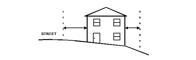 ce
ce
B. Measurements are shortest distance. When measuring a required distance, such as the minimum distance between a structure and a property line, the measurement is made at the closest or shortest distance between the two objects. An exception is stated in subsection (C). When the distance being is measured is between two land uses, the minimum distance measurement shall be from property line to property line, with the exception of measurements between adult businesses, as identified in Section.25.32.2 (D)(3).
C. Measurement of vehicle stacking or travel areas. Measurement of a minimum travel distance for vehicles stacking lane distances, are measured down the center of the vehicle travel area except where provided in the Zoning Ordinance. For example, travel lanes are measured along center line the arc of the driveway or traffic lane.
25.51.4 Measuring parcels
A. Coverage. Lot coverage is composed by the total of all horizontal areas occupied by structures as regulated by the Zoning Ordinance. Any deck or platform structure over 30 inches in height is included in the measurement. See Section 25.30.6 (Exceptions to Height Limits and Setback Requirements) and Section 25.25.10.6 (Exemptions from Zoning Ordinance Requirements).
B. Depth. Lot depth is measured using the least restrictive of one the following methods (see Figure 25-10: Measuring Lot Depth below):
1. The distance from the midpoint of the front property line and the midpoint of the rear property line; or
2. When the rear property line is formed by two or more lines, the measurement shall be from the midpoint of a line formed by connecting the midpoints of the side-most rear property lines to the front property line.
3. Where no rear property line is apparent, the rear lot line shall be a line 10 feet in length within the lot, parallel to and at the maximum distance from the front property line.
When lot depth is unable to be determined using the prescribed methods, the Director shall determine the most reasonable determination.
Figure 25-11: 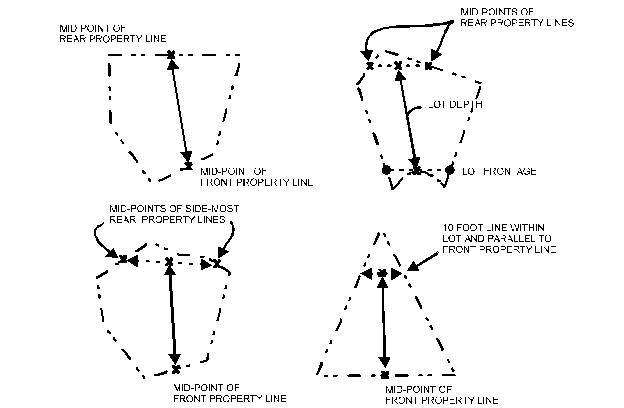 Measuring Lot Depth
C. Frontage. Frontage shall be measured according to the following applicable methods:
1. Frontage, Building. The lineal length of any portion of a building facing any street or common parking area.
2. Frontage, Residential Parcel. The horizontal measurement of, or tangent to, the midpoint of the front property line extending to the side property lines or except as follows:
a. Flag Parcel. For a parcel with a fee ownership extending from a street or right-of-way to the building area of the parcel, the measurement shall be taken from the adjacent side with the smaller dimension.
b. Corner Parcels. For corner lots, all sides abutting a street is considered frontage. The front of the parcel is the side with the smaller dimension.
D. Width. The horizontal measurement of a line formed at the front setback distance required by the applicable zoning district, extending to the side property lines. In residential districts, the measurement is taken 25 feet from the front property line or the front setback to a garage, whichever width is greater.
E. Maximum Coverage of Required Rear Yard. The coverage for additions and accessory buildings is calculated using the following method:
1. Calculations. If the rear yard setback is 20 feet on a lot measuring 60 feet by 100 feet, then the lot requires a rear yard area of 1,200 square feet. Therefore, the maximum coverage of the rear yard area for additions is 20 percent of the required rear yard area which is (.20 x 1,200) = 240 square feet. See the example provided in Figure 25-11: Rear Yard Coverage.
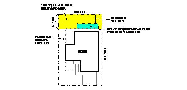 Figure 25-12: Rear Yard Coverage
25.51.5 Measuring Height
A. Buildings. Building height shall be measured plumb from the highest structural part of a building (not including a chimney) to the building’s finish grade. For buildings with basements, the measurement shall be measured plumb to the point where finish grade would have existed had the basement not been installed.
Figure 25-13: Building Height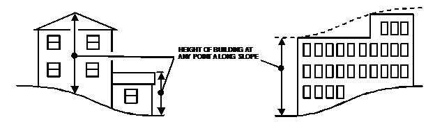
B. Other Structures. Specific measurements provisions are provided below.
1. Retaining Walls and Fences. Walls and fences on top of retaining walls are measured from the ground level on the higher side of the retaining wall.
2. Decks. Deck height is determined by measuring at any point along the slope directly beneath the platform to the top of the walking surface of the deck. The height of a roof or similar overhead structure for a deck is measured according to paragraph (A).
25.51.6 Measuring Building Transparency
A. Building Transparency. Building transparency shall be the percentage of the vertical surface area of ground floor and upper floor walls along the building frontage that is constructed with transparent materials, measured from finished floor to finished ceiling. This includes windows, transparent glazing, transoms, and doors.
Figure 25-14: Building Transparency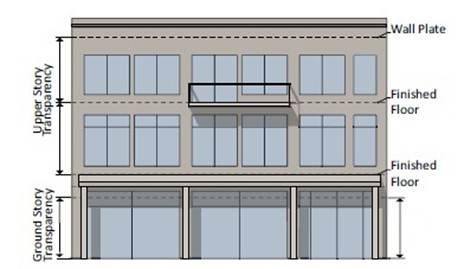
(Ord. No. 2025-01, § 15.)