


Chapter 23.325
OVERLAY ZONING DISTRICTS
Sections:
23.325.020 Convention (CO) overlay zoning district.
23.325.030 Transit oriented development (TOD) overlay zoning district.
23.325.040 Flood (F) overlay zoning district.
23.325.050 Planned development (PD) overlay zoning district.
23.325.060 Planned development – County/city initiated (PDC) overlay zoning district.
23.325.070 Parkway corridor (PC) overlay zoning district.
23.325.080 Surface mining (SM) overlay zoning district.
23.325.090 Sunridge general commercial (SGC) overlay zoning district.
23.325.010 Purpose.
The overlay zoning districts established in this chapter are designed to supplement the use regulations and/or development standards of the applicable underlying base zoning district by recognizing distinctive areas of the city that have special and unique social, architectural, or environmental characteristics which require special considerations not otherwise adequately provided by the underlying base zone applicable to the property. The application of these overlay zoning districts emphasizes the need for special attention in planning projects in the area governed by the overlay. The provisions of this chapter shall apply to all parcels of land located within the designed boundaries of an overlay district as illustrated on maps contained in this chapter and on the city zoning map. On the zoning map, overlay zoning districts shall be designated by their representative symbol along with the base zoning district in a format determined by the director. In the event of a conflict with the regulations of the underlying base zoning district and the overlay zoning district, the provisions of the overlay zoning district shall apply. [Ord. 4-2017 § 3 (Exh. B); Ord. 12-2011 § 3 (Exh. A); Ord. 27-2008 § 1 (Exh. A § 2.9.010)].
23.325.020 Convention (CO) overlay zoning district.
A. Purpose and Intent. The purpose of the convention (CO) overlay zoning district is to establish an area in the city specifically for the development of a convention center with related and supporting uses. The convention district is intended to be a special place in the city that is entertaining, vibrant, and inviting to tourists, visitors, and residents alike. This overlay district supplements the provisions of the underlying zoning districts for the special purposes identified herein. Where there is conflict between this overlay district and the underlying base district, the overlay district regulations prevail.
B. Convention Overlay District Area. The convention overlay zoning district is applied to those parcels described in Figure 23.325-1 (Convention Overlay District Area), consistent with the General Plan’s convention overlay. The convention overlay district is generally defined as that area south of Highway 50, east of Kilgore Road, north of Sun Center Drive, and west of Citrus Road.
Figure 23.325-1: Convention Overlay District Area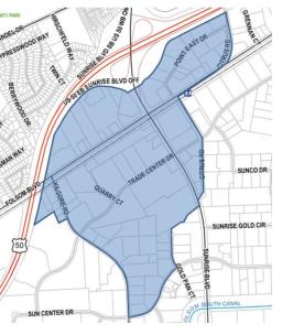
C. Allowed Uses. Table 23.325-1 identifies the allowed use provisions specific to the convention overlay zoning district. The allowed use provisions of Table 23.325-1 supersede and replace the allowed use provisions of the underlying base zoning district of the applicable property. Similar uses may be determined as identified in this title. The allowed use provisions are listed in compliance with Chapter 23.304 RCMC (Land Use Classification).
Use regulations in the table are shown with a representative symbol by use classification listing: “P” symbolizes uses allowed by right, “AUP” symbolizes uses that require approval of an administrative use permit, “C” symbolizes uses that require approval of a conditional use permit, and “N” symbolizes uses that are not permitted.
|
Land Use Category |
Convention Overlay Zoning District |
Special Use Regulations |
|---|---|---|
|
Residential Uses |
||
|
Dwelling, Multifamily |
P1 |
|
|
Home Occupations |
C |
RCMC 23.901.030 |
|
Live-Work Facility |
C |
RCMC 23.901.040 |
|
Recreation, Education, and Public Assembly Uses |
||
|
Clubs, Lodges, and Private Meeting Halls |
P |
|
|
Community Centers/Civic Uses |
P |
|
|
Convention Center |
P |
|
|
Indoor Amusement/Entertainment Facility |
P |
|
|
Indoor Fitness and Sports Facility |
AUP |
|
|
Libraries and Museums |
P |
|
|
Outdoor Commercial Recreation |
AUP |
|
|
Parks and Public Plazas |
P |
|
|
Public Safety Facility |
P |
|
|
Religious Institutions |
C |
|
|
Schools, Private and Special/Studios3 |
P |
|
|
Schools, Public3 |
P |
|
|
Theaters and Auditoriums |
P |
|
|
Utility, Transportation, and Communication Use Listings |
||
|
Broadcasting and Recording Studios |
P |
|
|
Heliports |
C |
|
|
Park and Ride Facility |
P |
|
|
Telecommunication Facility |
C |
RCMC 23.907.020 |
|
Transit Stations and Terminals |
C |
|
|
Utility Facilities and Infrastructure |
C |
RCMC 23.907.030 |
|
Retail, Service, and Office Uses |
||
|
Alcoholic Beverage Sales (off-premises consumption)2 |
C |
|
|
Art, Antique, Collectable |
P |
|
|
Artisan Shop |
P |
|
|
Banks and Financial Services |
P |
|
|
Bars and Nightclubs |
C |
|
|
Brew Pub2 |
P |
|
|
Business Support Services |
P |
|
|
Child Day Care Facility |
C |
|
|
Commercial Marijuana Uses |
N |
|
|
Convenience Store |
P |
|
|
Drive-In and Drive-Through Sales and Service |
C |
RCMC 23.910.030 |
|
Home Improvement Supplies |
AUP |
|
|
Hotels and Motels |
P |
|
|
Hotels and Motels, Extended Stay |
C |
|
|
Medical Services, General |
P |
|
|
Medical Services, Extended Care |
P |
|
|
Medical Services, Hospitals |
P |
|
|
Neighborhood Market/Grocery Stores/Supermarket |
P |
|
|
Offices, Business and Professional |
P |
|
|
Offices, Accessory |
P |
|
|
Personal Services |
P |
|
|
Restaurants |
P |
|
|
Retail, Accessory |
P |
|
|
Retail, General |
P |
|
|
Tasting Room2 |
P |
|
|
Veterinary Facility |
AUP |
|
|
Automobile and Vehicle Uses |
||
|
Auto and Vehicle Sales and Rental |
AUP |
|
|
Car Washing and Detailing |
C |
RMC 23.913.050 |
|
Service Stations |
C |
|
|
Vehicle Services, Minor |
AUP |
|
|
Industrial, Manufacturing, and Processing Uses |
||
|
Brewery, Winery, Distillery2 |
P |
|
|
Manufacturing – Small Scale |
AUP |
|
|
Printing and Publishing |
AUP |
|
|
Research and Development |
AUP |
|
|
Warehousing |
AUP |
|
|
Notes: |
||
|
1. For mixed-use zones, the use is permitted in conjunction with the predominant use of the underlying base zoning district. In other words, this use is only allowed as part of an integrated development. 2. Off-premises sale of alcohol is an allowed use where such sales are incidental to an allowed use that provides on-site alcohol consumption (restaurant, brew pub, tasting room, etc.). 3. Dormitories on any parcel that is part of a contiguous campus are permitted as an accessory use to the public or private school. |
||
D. Development Standards. The following development standards are applicable to the convention overlay zoning district. These standards, along with other development standards (e.g., landscaping requirements, parking standards) in this title and citywide design guidelines, are intended to assist property owners and project designers in understanding the city’s minimum requirements and expectations for high quality development. Where site development standards listed herein are in conflict with the site development standards in other chapters of this code or the underlying zoning district, these standards shall apply. The designated approval authority will review development applications against these standards to determine compliance with applicable zoning regulations.
|
Development Standard |
Convention Overlay District |
|---|---|
|
Density1 |
|
|
Minimum |
10 du/ac |
|
Maximum |
40.0 du/ac |
|
Floor Area Ratio2 |
|
|
Minimum |
0.25 |
|
Maximum |
3.0 |
|
Setbacks |
|
|
Front and Street-Side |
0 ft. |
|
Rear |
10 ft. |
|
Between Structures |
10 ft.3 |
|
Interior |
0 ft. |
|
Residential, Standalone Structure4 |
Refer to setbacks for the MDR zone |
|
Height Limit |
|
|
Primary Structures |
No maximum5 |
|
Notes: |
|
|
1. The minimum and maximum density standards are only applicable to mixed-use and integrated developments that include residential uses. Residential projects shall include a minimum of four units. |
|
|
2. Includes residential uses and square footage. See Article 11 of this title for definition of floor area ratio (FAR). |
|
|
3. The distance between structures may be modified as part of design review; however, any modifications must be consistent with the Uniform Building Code. |
|
|
4. For residential units developed as part of an integrated development but not in the same building as the primary use(s), refer to the MDR zone for all setbacks. In all other instances, the setbacks shall be the same as the primary structure(s). |
|
|
5. While there is no height maximum, the regulations of the Federal Aviation Administration (FAA) limit the height of structures to between 150 and 350 feet based on location. See the safety element of the General Plan for more information. FAA approval is required for all structures over 150 feet in height. |
|
E. Parking Standards. Parking standards for uses in the convention overlay zoning district shall be consistent with Chapter 23.719 RCMC (Parking and Loading). Required off-street loading/unloading and passenger loading areas shall also be consistent with applicable provisions of Chapter 23.719 RCMC (Parking and Loading).
F. Exceptions. The council desires to provide flexibility for projects within the convention overlay district that will benefit the community in specific, identified ways. In conjunction with a major design review, project-level CEQA review, and any other required entitlements, an applicant may request that the council approve an exception to allow a development project that does not strictly adhere to the convention overlay development standards identified in Table 23.325-2. The council may grant an exception for any development standard in Table 23.325-2 for projects that are uses allowed in Table 23.325-1, and meet at least four of the following six conditions:
1. Will fulfill a compelling community need, as indicated by an existing city goal, General Plan policy, budget priority, or other council adopted policy document.
2. Will improve an existing blighted situation by removing 100 percent of the blight located upon the subject property.
3. Will provide unmet services to a currently underserved community.
4. Will create at least 15 new permanent full-time jobs (or new jobs equivalent to at least 15 full-time jobs) or a minimum of one job per 500 square feet.
5. Will generate annual sales tax contributions to the city in excess of $25,000.
6. Investments in the property will increase the property tax revenue for the subject parcel(s) by at least 250 percent.
To the extent practical, development projects should comply with the development standards in Table 23.325-2. All projects remain subject to design review as established in Chapter 23.140 RCMC (Minor Design Review) and Chapter 23.141 RCMC (Major Design Review). An exception request must be included and will be reviewed in conjunction with the project’s design review application. It is the applicant’s responsibility to request relief from the development standards in Table 23.325-2 and provide justifications for why standards cannot be met. It is also the applicant’s responsibility to provide evidence of compliance with at least four of the conditions listed in this section to support the exception request. The council is the approval authority for all exception requests.
Under no circumstance shall an exception result in any of the following:
1. Allow a land use not otherwise permitted or conditionally permitted in the zone;
2. Allow a detrimental environmental impact not adequately analyzed;
3. Waive a specific prohibition; or
4. Waive or modify a procedural requirement.
The procedure for granting exceptions allowed under this provision is provided in RCMC 23.110.130. In granting the exception, the council shall make the following findings:
1. The proposed project qualifies for an exception by meeting at least four of the six conditions required for granting an exception as defined in this subsection (F).
2. The council has determined that the proposed project has adhered to the development standards in Table 23.325-2 to the fullest extent practicable.
3. The applicant has provided substantial evidence that the conditions for the exception will be met following construction and operation of the project. Further, the applicant has agreed to conditions of approval that provide assurances that these requirements will likely be met or exceeded throughout the life of the project.
4. Granting the exception will not adversely affect the interests of the public or the interests of the residents and property owners in the vicinity of the premises in question, and shall not establish a precedence for other project requests.
5. Granting the exception will not endanger the public health and safety. [Ord. 15-2023 § 3 (Exh. A); Ord. 11-2021 § 3 (Exh. A); Ord. 4-2018 § 3 (Exh. A); Ord. 4-2017 § 3 (Exh. B); Ord. 1-2017 § 3; Ord. 11-2015 § 3; Ord. 19-2013 § 3 (Exh. A); Ord. 18-2013 § 3 (Exh. A); Ord. 12-2011 § 3 (Exh. A); Ord. 27-2008 § 1 (Exh. A § 2.9.020)].
23.325.030 Transit oriented development (TOD) overlay zoning district.
A. Purpose and Intent. The purpose of the transit oriented development (TOD) overlay zoning district is to promote and provide for higher density and intensity uses as part of or in proximity to transit stations. The objective of locating more intensive uses near transit stations is to promote transit services along major transit corridors of the city. The transit oriented development overlay zoning district implements the local transit oriented development and regional transit oriented development land use categories of the General Plan.
B. Applicability.
1. TOD Designation. The transit oriented development overlay zoning district shall be applied to properties that are located within one-quarter mile of an existing or planned light rail/streetcar station or bus rapid transit station. In determining the extent of the applicability, a circle of one-quarter mile in radius shall be drawn from a central point at the designated station location (e.g., station platform). See Figure 23.325-2 (Transit Oriented Development Overlay Zoning District) for a prototypical example of a TOD overlay.
Figure 23.325-2: Transit Oriented Development Overlay Zoning District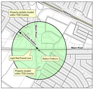
2. Properties Partially Located within the TOD Overlay. The provisions of the transit oriented development overlay zoning district shall only apply to those portions of property located within the one-quarter-mile radius circle. Those portions of parcels zoned transit oriented development overlay but not included within the one-quarter-mile radius circle shall have development standards consistent with the underlying base district (see section on integrated development as described later in this chapter) and may only be developed consistent with the development standards of the base district.
C. Development Standards. The following development standards are applicable to the transit oriented development overlay zoning district. These standards, along with other development standards (e.g., landscaping requirements, parking standards) in this title and citywide design guidelines, are intended to assist property owners and project designers in understanding the city’s minimum requirements and expectations for high quality development. Where site development standards listed herein are in conflict with the site development standards in other chapters of this code or the underlying base zoning district, these standards shall apply. The designated approval authority will review development applications against these standards to determine compliance with applicable zoning regulations.
The table describes development standards for two types of transit oriented developments: TODs generally and TODs as part of regional town centers. For the majority of transit oriented developments, the general development standards of the “TODs Generally” column will apply. In those cases where a transit oriented development overlay is applied to a regional town center base zoning district, the development standards of the “TODs as Part of a Regional Town Center” shall apply. The intent of these two sets of standards is to implement the unique development standards of the local TOD and regional TOD land use categories under the city’s General Plan.
|
Development Standard |
TODs Generally |
TODs as Part of a Regional Town Center |
|---|---|---|
|
Density1 |
||
|
Minimum |
20.0 du/ac |
|
|
Maximum |
80.0 du/ac |
|
|
Floor Area Ratio2 |
||
|
Minimum |
0.50 |
0.65 |
|
Maximum |
2.5 |
3.0 |
|
Development Standard |
TODs Generally |
TODs as Part of a Regional Town Center |
|
Height (maximum) |
80 feet |
No maximum3 |
|
Notes: |
||
|
1. The minimum and maximum density standards are only applicable to mixed-use and integrated developments that include residential uses. Residential projects shall include a minimum of four units. |
||
|
2. Includes residential uses and square footage. See Article 11 of this title for definition of floor area ratio (FAR). |
||
|
3. While there is no height maximum, the regulations of the Federal Aviation Administration (FAA) limit the height of structures to between 150 and 350 feet based on location. See the safety element of the General Plan for more information. FAA approval is required for all structures over 150 feet in height. |
||
[Ord. 4-2017 § 3 (Exh. B); Ord. 12-2011 § 3 (Exh. A); Ord. 27-2008 § 1 (Exh. A § 2.9.030)].
23.325.040 Flood (F) overlay zoning district.
A. Purpose and Intent. The flood (F) overlay zoning district as defined by public works and the General Plan Safety Element comprises all land covered by rivers, creeks, and streams and land subject to flooding within the city. The council, in adopting the regulations in this section, recognizes that:
1. The promotion of the orderly development and beneficial use of lands subject to recurrent flooding is necessary if the potential property damage which results from improper development is to be minimized.
2. There is a need to protect current and future occupants of land subject to flooding from the physical damage of flooding.
3. The health, general welfare, and safety of the public of the city as a whole requires that lands subject to flooding be strictly regulated as to the uses permitted on the land and the amount of open space which separates buildings and structures.
4. Inundation frequently causes extensive property damage.
5. Strict regulation of flood lands is necessary to protect prospective buyers of land from deception as to the utility of the land within the flood zones.
B. Prohibition. No building, structure, vehicle, sign, or area in any zone to which the flood overlay designation is applied shall be used, nor shall any building, structure, sign, or vehicle be erected, altered, moved, enlarged, or stored in any zone to which the flood overlay designation is applied, except as hereinafter specifically provided in this section or elsewhere in this title; nor shall any area, building, structure, vehicle, or sign be used in any manner so as to create problems detrimental to the public health, safety, or general welfare, or so as to constitute a public nuisance. Any building, structure, vehicle, sign, or lot, or the use of any building, structure, vehicle, or lot, in any zone to which the flood overlay designation is applied shall be regulated and governed by the provisions of this section, the regulations and provisions applicable to the base zone to which the flood overlay designation is applied, and the general regulations and conditions of this title. If there are any conflicts between the flood overlay zoning district and the base zone to which it is applied, the provisions of the flood overlay zoning district shall apply.
C. Elevations. No building or structure designed for human habitation shall hereafter be erected, altered, moved, or enlarged with a first floor elevation lower than required by the Sacramento County water agency drainage ordinance and regulations adopted pursuant thereto.
D. Area. Each lot or parcel shall have a minimum lot area and/or density as specified in the base zoning district. If neither a public water supply nor a public sewerage facility is in use, the net lot area for each lot or parcel shall be not less than one acre.
E. Lot Width. Each lot or parcel shall have a minimum lot width as required by the base zoning district.
F. Determination of Zoning Boundaries. For purposes of the flood overlay zoning district, the following rules shall apply when determining the boundaries of the zone:
1. Zoning boundaries of the flood overlay district are intended to represent the 100-year floodplain and protected 200-year floodplain as determined by public works. The 100-year floodplain will be based on the best available information, which may include the National Flood Insurance Program flood insurance rate map effective July 19, 2018, County Drainage Master Plan, historic flooding events, or other available information. The protected 200-year floodplain shall be based on the 200-year floodplain map shown in General Plan Safety Element.
2. When public works revises the 100-year flood and/or the 200-year flood elevations based upon detailed engineering data, the zoning boundaries of the flood overlay zoning district may be adjusted by the planning director so as to accurately reflect the 100-year floodplain.
3. Upon development of a property, the designated approving authority shall determine the exact elevation of the 100-year floodplain based on a topographic survey of the property at one-foot intervals and the 100-year flood elevation as determined by public works. [Ord. 9-2018 § 3; Ord. 4-2017 § 3 (Exh. B); Ord. 7-2016 § 2 (Exh. 1B); Ord. 12-2011 § 3 (Exh. A); Ord. 27-2008 § 1 (Exh. A § 2.9.040)].
23.325.050 Planned development (PD) overlay zoning district.
A. Purpose. The purpose of the planned development (PD) overlay zoning district is to encourage a creative and more efficient approach to the use of land, to maximize choice in the type of environment available to the people of the city, and to encourage more efficient allocation and maintenance of privately controlled common open space through the redistribution of overall density where such rearrangement is desirable and feasible. While this overlay district has been established to reflect previous actions of the county of Sacramento prior to incorporation of the city, subsequent development does not require a planned development overlay zoning district to establish development rights consistent with this title and the city’s General Plan. Existing planned development overlay zoning districts are hereby incorporated into this title by reference and are considered consistent with the city’s General Plan.
B. Intent of the Planned Development Overlay Zoning District. The intent of the planned development overlay zoning district is to carry out the purpose as set forth above by providing the means of greater creativity and flexibility in design than are provided under the strict application of the zoning and subdivision ordinances, while at the same time preserving the public interest, health, safety, welfare, and property values. Various land uses may be combined in a planned development zone including combinations of residential, commercial, industrial, utility, institutional, educational, cultural, recreational, and other uses, provided the combination of uses results in a balanced and stable environment. A PD zone may be combined with any other zoning classification except permanent agricultural or agricultural hold zones, provided the underlying base zoning district is consistent with the General Plan.
C. Criteria. The criteria for establishing new planned development overlay zoning districts are as follows:
1. Size. A planned development, or unit thereof, shall be of sufficient size, composition, and arrangement that its composition, marketing, and operation are feasible as a complete unit independent of any subsequent unit.
2. Permitted Uses. All uses which are authorized in the base zone(s) with which the planned development overlay zoning district is combined, which include uses which are authorized only with a use permit, provided the uses are approved and made part of the development plan as provided in this section. In residential developments, the applicant must show that accessory commercial uses are intended to serve principally the residents of the development.
3. Land Use Intensity. The planned development shall be at a land use intensity which conforms to the city’s General Plan and complements existing permitted uses in the neighborhood. If the planned development proposed indicates a greater intensity of land use than is permitted by existing zoning regulations, the applicant shall show that the design of the project merits such a change in zoning and will not:
a. Create traffic congestion in the streets which adjoin or are near the planned development;
b. Create a burden on parks, schools, and other public facilities and utilities which serve or are proposed to serve the planned development;
c. Have an undue and adverse impact on the reasonable enjoyment of neighboring property.
An increase in land use intensity shall be compensated for by additional amenities to be achieved by the amount, location, and proposed use of open space and location, design, and type of development.
4. Design Standards. The council may permit deviations from the standards in the base zones with which the planned development overlay zoning district is combined provided the developer demonstrates by his design proposal that the objectives of the General Plan, the subdivision ordinance (Chapter 22.150 RCMC), and this title will be achieved.
5. Common Open Space. The council may adopt regulations to govern the amount, use, and location of open space. After development, the common open space may be conveyed to a public agency or private association. The council, prior to any conveyance of common open space, shall approve all agreements and instruments relating to use, maintenance, and ownership thereof. The council may also require the dedication of development rights or scenic easements to ensure that common open space will be maintained. The council may further require that instruments of conveyance or covenants or deed restrictions of associations provide that, in the event the common open space is not maintained in a condition consistent with the approved development plan, the city may, at its option, cause such maintenance to be performed and assess the costs to the affected property owners or responsible association. If the common open space is dedicated, conveyed, or designed for use by the general public and so used, any assessment of maintenance costs shall be made by benefit areas which are not necessarily restricted to the subject planned development overlay zoning district.
D. Preliminary Plan.
1. Purpose. The purpose of the preliminary plan is to require the developer to demonstrate the feasibility and general design concept of a proposed development to the department. Prior to submitting an application for zone change to the planned development overlay zoning district, the applicant shall submit and receive approval from the director of a preliminary plan for the full area to be covered by the planned development overlay zoning district. Approval of the preliminary plan does not grant or vest development rights, but rather ensures that the proposed development will comply with the goals and policies of the city’s General Plan and other standards and regulations of the city prior to zone change.
2. Procedure. The initial step to be taken by the developer is to submit a preliminary plan to the department. The plan shall include:
a. Maps or drawings which may be schematic in form.
b. Proposed land uses, the approximate number of dwelling units, acres and population density for each area of land, and existing uses of surrounding property.
c. Proposed circulation system, indicating both public and private streets.
d. Public uses including schools, parks, recreation areas, and other open spaces.
e. The use and general description of each different type of structure.
f. Nature of the applicant’s interest in the land proposed to be developed.
g. Written explanation of the nature of the proposed development and the deviations from regulations otherwise applicable to the property.
h. Proposed sequence and schedule of development.
i. Other contents as deemed necessary by the director and council.
3. Action by the Department. Review and processing of the preliminary plan application shall be consistent with the provisions of Chapter 23.110 RCMC (Application Processing). The designated approving authority for the preliminary plan shall be the director; however, the director shall have the authority to elevate the preliminary plan review to the council.
E. Proposed Development Plan and Request for Planned Development Overlay Zoning District. Within one year after approval of the preliminary plan, an application may be filed with the director for a planned development overlay zoning district. The petitioner shall include with the application for zone change his proposed development plan for all or a portion of the property included within the preliminary plan, which shall include all information required for the preliminary plan and the following:
1. Maps showing existing topography, tree cover, buildings, streets, and other existing physical features.
2. Detailed breakdown of the proposed land use showing lot lines, location of buildings, parking areas, common grounds, recreation improvements and structures, and open space around buildings and structures.
3. Elevation drawings of typical proposed structures and improvements for each proposed use, except detached single-family dwellings.
4. At least one perspective drawing or model which will demonstrate the architectural character of the project.
5. Proposed agreements, deed restrictions, bylaws, and articles of incorporation which relate to the preservation or maintenance of open space and associations created to preserve and maintain said open space.
6. A schedule and sequence of development for all of the property included in the preliminary development plan even though the applicant elects to include only a portion of the property in the proposed tentative development plan.
F. Action on the Proposed Development Plan and Request for Planned Development Overlay Zoning District.
1. The process for approving a proposed development plan and request for zone change to the planned development overlay zoning district shall be the same as for zoning amendments as provided for in Chapter 23.146 RCMC (Zoning Amendments).
2. Findings. In addition to the findings for approval of a zoning amendment, the designated approval authority shall also make all of the following findings when approving a zone change to the planned development overlay zoning district:
a. The proposed development will carry out the intent of the General Plan.
b. The proposed development is of sufficient size and is designed so as to provide a desirable environment within its own boundaries.
c. The proposed development is compatible with existing and proposed land uses in the surrounding area.
d. Any exceptions to the standard requirements of the base zoning district and the provisions of this title are justified by the design of the development. In the case of residential areas, the rearrangement of dwellings and the mixing of dwelling types shall be justified by larger and more usable open spaces.
e. There is adequate assurance that all public improvements will be installed at the scheduled times as required by the public works department.
f. There is adequate assurance that the development schedule will be met.
g. The existing or proposed utility services are adequate for the uses and population densities proposed.
G. Designation of Planned Development Overlay Zoning District. A planned development overlay zoning district shall be delineated on the zoning map in a manner similar to that of any other overlay district by showing a name, number, symbol, or other designation after the base zone for the subject property(ies), as determined by the director, which distinguishes it from other overlay zones, base zoning districts, or special purpose zones.
H. Adoption by Reference. The following planned development overlay zoning district(s) has/have been adopted as part of this title by reference and is/are so designated on the zoning map of the city:
1. Briarwood Coloma Planned Development (adopted by Ordinance 71-PD-2, amended by Ordinances 71-PD-2A, 71-PD-2A1, 71-PD-2C, and 71-PD-2D).
I. Subsequent Approvals. No subsequent approvals, including tentative maps, conditional use permits, and other discretionary permits, as well as building permits, grading plans, improvement plans, sign permits, temporary sign permits, and other ministerial permits/actions, shall be approved unless they are substantially compliant with the provisions of the adopted planned development and other regulations of this title. [Ord. 4-2017 § 3 (Exh. B); Ord. 13-2013 § 4 (Exh. B); Ord. 12-2011 § 3 (Exh. A); Ord. 27-2008 § 1 (Exh. A § 2.9.050)].
23.325.060 Planned development – County/city initiated (PDC) overlay zoning district.
A. Purpose. This section establishes the procedure whereby the council may initiate proceedings to regulate certain property through the process of a county-initiated planned development overlay zoning district. The council recognizes that there are areas throughout the city that have unique environmental, economic, historic, or architectural features and that too little attention has been given through the application of standard zone regulations to these special characteristics. It is the purpose of this section to provide for the city to guide the regulation of such areas so as to preserve such unique characteristics. While this overlay district has been established to reflect previous actions of the county of Sacramento prior to incorporation of the city, subsequent development does not require a planned development – county/city initiated overlay zoning district to establish development rights consistent with this title and the city’s General Plan. Existing planned development – county/city initiated overlay zoning district zones are hereby incorporated into this title by reference and are considered consistent with the city’s General Plan.
B. Designation. A planned development – county/city initiated overlay zoning district shall be delineated on the zoning map in a manner similar to that of any other overlay district by showing a name, number, symbol, or other designation after the base zoning district for the subject property(ies), as determined by the director, which distinguishes it from other overlay zoning districts, base zoning districts, or special purpose zones.
C. Initiation of Zone. The council may initiate proceedings to place parcels within the planned development – county/city initiated overlay zoning district. The procedure for zoning property to the planned development – county/city initiated overlay zoning district shall be the same as for changing the zone as provided in Chapter 23.146 RCMC (Zoning Amendments).
D. Content of County/City Initiated Planned Development Ordinance.
1. The following provisions are mandatory and shall be included in each planned development – county/city initiated overlay zoning district ordinance:
a. A list of permitted uses.
b. Performance and development requirements relating to yards, lot area, intensity of development on each lot, parking, landscaping, and signs.
c. Other design standards appropriate for the specific planned development.
d. Legal description of property covered by the ordinance.
e. Reasons for establishment of a planned development – county/city initiated overlay zoning district on the particular property.
2. The following provisions are permissive and are not intended to be an exclusive list of the provisions that could be part of a planned development – county/city initiated overlay zoning district ordinance:
a. Procedures for Review of Proposed Development. The procedures could include:
i. Types of projects that require review.
ii. Documents required from developers.
iii. Hearing procedures, if any.
b. Regulations relating to nonconforming lots, uses, structures, and signs.
c. Time phasing and sequence of development projects.
E. Application for Amendment to the Planned Development – County/City Initiated Overlay Zoning District. The procedures for filing an amendment to the planned development – county/city initiated overlay zoning district adopted pursuant to this title shall be the same as for any amendment to the zoning code.
F. Adoption by Reference. The following planned development – county/city initiated overlay zoning district(s) has/have been adopted as part of this title by reference and is/are so designated on the zoning map of the city:
1. Sunriver Planned Development (adopted by Ordinance 77-PDC-4, amended by Ordinance SZC 93-0037). [Ord. 4-2017 § 3 (Exh. B); Ord. 12-2011 § 3 (Exh. A); Ord. 27-2008 § 1 (Exh. A § 2.9.060)].
23.325.070 Parkway corridor (PC) overlay zoning district.
A. Purpose. The parkway corridor (PC) overlay zoning district, as shown on the zoning map, shall be used to regulate property along the American River in the city. The goals promoted by establishment of this zone include:
1. Implement the goals and policies of the city’s General Plan relative to preservation of the American River Parkway.
2. Preserve and enhance the American River and its immediate environment consistent with the goals and policies of the American River Parkway Plan.
3. Ensure, to the extent possible, the compatibility of land uses within the American River Parkway and land adjacent to the parkway for their mutual benefit.
4. Ensure that development with access within and adjacent to the American River Parkway is designed to reduce as much as possible visible intrusion into the parkway and to complement the naturalistic amenities of the parkway.
5. Provide flexibility in development requirements such as setback, height, bulk, and landscaping applicable to parcels of property subject to the regulations of the parkway corridor (PC) zone.
6. Minimize risks to public health, safety, and welfare in areas which are potentially threatened by erosional processes.
7. Ensure that bluff development, including related stormwater runoff, foot traffic, site preparation, construction activity, irrigation, and other activities and facilities accompanying such development, does not create or contribute significantly to problems of erosion or geologic instability on the site or on surrounding areas.
8. Ensure that bluff development is sited and designed to ensure stability and structural integrity for its expected economic life span while minimizing alteration of natural landform features.
9. Ensure that development within the American River Parkway corridor zone occurs in a manner which maintains a safe environment for homes and other improvements and protects the aesthetic and environmental quality of the parkway.
10. Ensure that any improvements within the American River Parkway that require city ministerial or discretionary approvals are consistent with the American River Parkway Plan.
B. Applicability of Parkway Corridor Overlay Zoning District Designation.
1. Property regulated by the parkway corridor overlay zoning district shall be identified in the city zoning map consistent with the provisions of this title.
2. The parkway corridor overlay zoning district may be applied to property within the city adjacent to or near the American River for which the council determines that land development may affect the stability of bluffs or terraces or have an impact on the preservation or enhancement of scenic, recreational, fishery, or wildlife values along or near the American River.
3. The parkway corridor overlay zoning district contains erosion zones based on geologic hazards resulting from erosional processes. Erosion zones have been defined with development setbacks which identify areas potentially subject to erosion within the next 100 years. Property owners and developers must address the erosion problems associated with the erosion zones prior to development in the applicable erosion zone.
4. The parkway corridor overlay zoning district establishes provisions for determining allowed uses when reviewing projects on land within the American River Parkway that require issuance of a permit by the city.
C. Definitions. The following definitions apply to this chapter. The director or a designee shall resolve disputes with regard to a determination made establishing a bluff or terrace, the edge of a bluff or terrace, toe of a bluff or terrace, 100-year floodplain, designated floodway, or other significant topographic or geologic feature. Any person dissatisfied with the determination made by the director or a designee may appeal such determination as set forth in RCMC 23.104.040 (Referrals to council).
1. “Bluff” is an escarpment or steep face of rock, decomposed rock, sediment, or soil resulting from erosion, faulting, folding, or excavation of a landmass. A bluff may be planar or have a curved surface, or it may be steplike in section. As used in this zone, “bluff” is limited to those features having a vertical relief of 10 feet or more whose toe is subject to river erosion (see Figure 23.325-3).
Figure 23.325-3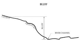
2. “Bluff edge” is the upper termination of a bluff. The bluff edge can be defined in the following manner:
a. When the top of the bluff is rounded away from the face of the bluff, the edge shall be defined as that point nearest the bluff at which the slope of the land surface becomes more or less continuous with the general slope of the surrounding land area going away from the river (see Figure 23.325-4).
Figure 23.325-4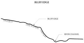
b. When there is a steplike feature at the top of the bluff face, the landward edge of the topmost riser shall be defined as the bluff edge (see Figure 23.325-5).
Figure 23.325-5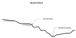
3. “Bluff face” shall be defined as that portion of the bluff’s land surface which extends in a downward gradient from the bluff edge to the toe (see Figure 23.325-6).
Figure 23.325-6
4. “Terrace” shall be defined as an elevated portion of rock, decomposed rock, sediment, or soil resulting from erosion, faulting, folding, or excavation of a landmass. A terrace may have a curved surface or it may be steplike in section. As used in this zone, a “terrace” is limited to those features having a vertical relief of 10 feet or more whose toe is not presently subject to river erosion (see Figure 23.325-7).
Figure 23.325-7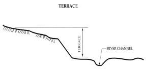
D. Use of County-Owned Property. Consistent with the regulations of Sacramento County, property owned or controlled by the county that is subject to the parkway corridor overlay zoning district shall require prior approval of the Sacramento County board of supervisors for any use of the property.
E. Authorized Uses in an Erosion Zone.
1. The following use is permitted in an erosion zone as described on Exhibits A through D at the end of this section and within the total setback distance as shown on Table 23.325-4 (Development Setbacks) upon submission of geotechnical data as set forth in subsection (J) of this section (Application Requirements) and approval of a conditional use permit by the designated approval authority:
a. Construction, enlargement, or modification of any building or structure for which a building permit is required.
2. Construction, erection, or installation of any structure, wall, abutment, or similar device intended to reinforce, stabilize, or otherwise protect any bluff or terrace from erosion, mass wasting, or similar land movement is permitted subject to the submission of geotechnical data as set forth in subsection (J) of this section (Application Requirements) and approval of a conditional use permit by the designated approval authority.
3. Notwithstanding other provisions of this title, the following uses, buildings, and structures, either located outside an erosion zone or within an erosion zone as described in Exhibits A through D at the end of this section, but outside the total setback distance as shown in Table 23.325-4 (Development Setbacks), are authorized without the grant of a conditional use permit upon compliance with the provisions of subsection (I) of this section (Submittal of Plans) and provided the buildings or structures meet the development standards specified in subsection (H) of this section (Development Standards); otherwise such uses, buildings, or structures shall not be erected or maintained without first obtaining a conditional use permit as set forth in subsection (E)(4) of this section.
a. One single-family detached dwelling, including mobile home, on each lot.
b. One two-family dwelling, including mobile home, on each lot.
c. Accessory uses, buildings, and structures (including swimming pools and appurtenant equipment) customarily incidental to and subordinate to single-family detached and two-family dwellings.
4. Unless otherwise provided in this title, all uses designated as either permitted or conditional uses in the underlying zone shall be authorized in the parkway corridor overlay zoning district provided a conditional use permit is first obtained from the designated approval authority.
F. Findings. In addition to the findings required by this title, when development is proposed within an erosion zone as described in Exhibits A through D of this section and within the total setback distance as shown on Table 23.325-4 (Development Setbacks), the designated approval authority shall not grant a conditional use permit pursuant to subsection (E) of this section unless it finds and records in writing that:
1. Development will be sited and designed to ensure stability and structural integrity for its expected economic life span while minimizing alteration of natural landform features.
2. Development will not create or contribute to significant problems of erosion or geologic instability on the site or on surrounding areas.
3. Development will maintain a safe environment for homes and other improvements and protect the aesthetics and environmental quality of the American River Parkway.
4. Development does not preclude or foreclose future recreation or open space potential in the American River Parkway.
5. There are adequate provisions included in the development proposal for maintenance and revegetation of the project area.
G. Authority of Hearing Body. Generally, development requirements of property including lot area, lot width, or public street frontage applicable to property located in the underlying zone shall apply to the uses authorized by subsection (E) of this section. However, the designated approval authority, in granting the conditional use permit, may impose any or all of the development requirements specified in this section if, in the judgment of the designated approval authority, the special requirements specified in this section are necessary to carry out the intent of this title.
The granting authority may:
1. Require a reasonable additional building setback or yard area, particularly in high terrace and bluff areas which overlook the American River.
2. Require the screening of any portion or all of the structure, building, or use through the use of walls or fences, the planting of locally native trees or shrubbery, or combinations thereof.
3. Require the modification of exterior features of structures where necessary to minimize physical or visual intrusion into the parkway.
4. Establish a limitation on the size or bulk of a building or structure.
5. Regulate the design and location of access drives and other features.
6. Regulate the location, design, and capacity of utilities.
7. Require the use of specific colors, lighting, and landscaping features as otherwise required by this chapter.
8. Regulate the design, as well as require the maintenance, of grounds, landscaping, or an irrigation or drainage system.
9. Regulate noise, vibration, odors, and other similar concerns within certain performance standards.
10. Require the phasing of development.
11. Require a bond or deposit of money to ensure completion of development as authorized by the permit.
12. Require the use of noncombustible roofing and siding materials to minimize structural loss in areas with limited accessibility and which are potentially threatened by the occurrence of fire originating from the parkway.
13. Require a fire-resistant buffer between the open areas of the parkway and structures adjacent to it, or require locally native plant varieties which are drought- and fire-resistant. A list of locally native plant varieties is maintained by the Cordova recreation and park district.
14. Require that disruption to natural riparian vegetation be minimized, and no trees which are native to the area and which are six inches in diameter or larger shall be damaged or removed unless in imminent danger of collapse from erosion.
15. Require that the area disrupted by the project be revegetated in accordance with a revegetation program utilizing an approved combination of locally native riparian trees, shrubs, and groundcover. If gabion, riprap, or other structural measures are used, require that they be screened from public view with locally native vegetation.
16. Require that the slope and appearance of the project area be compatible with the natural character of nearby slopes or riverbanks.
17. Require that, where feasible, vegetation be used to prevent further erosion. Gabions, rock and wire mattresses, or wire mesh over stone may be used where vegetative measures alone are insufficient, but the erosion control program shall include measures to minimize damage to riparian vegetation and wildlife. Riprap shall not be used unless slope, stream current, and existing native vegetation are favorable to providing substantial vegetative screening of the riprap. Rubble, gunite, cement or sandbags, bulkheads, fences, used tires, and similar materials or structures are prohibited.
18. Require the review of development at a specified time to ensure compliance with all conditions of approval, zoning agreements, ordinances, statutes, regulations, and procedures applicable at the time of development.
If the granting authority imposes any of the development requirements specified above, the designated approval authority shall find and record in writing as required by this title the circumstances which it determined necessary to require the imposition of any special development requirement.
H. Development Standards.
1. Development standards for uses, buildings, or structures on lots protected by levees maintained by a public agency.
a. Height. The maximum height of a building or structure shall not exceed the difference between the elevation of the finished grade of the building site and the elevation of that portion of the levee crown closest to the building site, plus five feet, plus one foot for each five feet by which the distance from the building structure to the landward toe of the levee exceeds 35 feet, but in no event greater than the height limitations set forth in the underlying zone.
b. Setback. No building or structure other than an accessory building is located closer than 35 feet, and no accessory building is located closer than 25 feet, to the landward toe of the levee.
2. Development standards for uses, buildings, or structures on lots not protected by levees maintained by a public agency, and also not within the total setback distance in an erosion zone as described on Exhibits A through D at the end of this section.
a. Accessory buildings shall not exceed 12 feet in height.
b. Dwellings and other structures shall be screened by live plantings of locally native trees and shrubs to minimize the visual impact of the dwelling or structure from the parkway.
c. Dwellings and structures shall be finished in earthtones as defined in Article 11 of this title (Definitions).
3. Development standards for uses, buildings, or structures on lots which are located within an erosion zone as described on Exhibits A through D at the end of this section and within the total setback distance for that zone as shown on Table 23.325-4 (Development Setbacks).
a. Accessory buildings shall not exceed 12 feet in height.
b. Dwellings and other structures shall be screened by live plantings of locally native trees and shrubs to minimize the visual impact of the dwelling or structure from the parkway.
c. Dwellings and structures shall be finished in earthtones as defined in Article 11 of this title (Definitions).
d. Accessory uses, buildings, and structures (including swimming pools and appurtenant equipment) customarily incidental to and subordinate to single-family detached and two-family dwellings shall not be located closer than 20 feet from the edge of a bluff or terrace.
e. Construction, erection, or installation of any fence, wall, abutment, or similar device shall not be located closer than:
i. Twenty feet from the edge of a bluff or terrace when proposed in Erosion Zone 1 or 2.
ii. Ten feet from the edge of a bluff or terrace when proposed in Erosion Zone 3 or 4.
f. No form of trenching, grading, earth filling, or similar disturbance of residual or transported soils shall occur within:
i. Twenty feet from the edge of a bluff or terrace when proposed in Erosion Zone 1 or 2.
ii. Ten feet from the edge of a bluff or terrace when proposed in Erosion Zone 3 or 4.
|
Erosion Zone |
Potential Recession Due to Long-Term Channel Migration1 |
Distance of Potential Short-Term Erosion Due to Slope Erosion2 |
Buffer Zone3 |
Total Setback4 |
|---|---|---|---|---|
|
1 |
0 |
20 feet |
20 feet |
40 feet |
|
2 |
30 feet |
20 feet |
20 feet |
70 feet |
|
3 |
30 feet |
10 feet |
20 feet |
60 feet |
|
4 |
30 feet |
10 feet |
20 feet |
60 feet |
|
5 |
* |
* |
* |
* |
|
Notes: |
||||
|
1. Long-term bluff recession is based on estimated channel migration rate and a 100-year time period. |
||||
|
2. Distance measured from edge of bluff which is potentially subject to erosion within 10 years. |
||||
|
3. Buffer zone added to allow for property remaining at end of 100-year period. |
||||
|
4. The total setback distance is measured from the edge of a bluff or terrace, whichever is closer to the river. |
||||
|
*The entire area within Zone 5 is potentially subject to erosion within a 100-year period. |
||||
Any reference to erosion zones in this chapter shall be shown on Exhibits A through D at the end of this section, which are hereby incorporated by this reference into this section.
I. Submittal of Plans. Any application for a building permit or other entitlement of use, building, or structure subject to the parkway corridor overlay zoning district authorized without a conditional use permit by subsection (E) of this section shall be reviewed by the director for compliance with the provisions of this chapter. The director may require a site plan as provided in subsection (J) of this section (Application Requirements) to make any determination. If, in the opinion of the director, the proposed development will not meet the development requirements provided in this chapter, the director shall inform the applicant that the building permit or other entitlement of use is disapproved. The director’s decision is not subject to an appeal.
J. Application Requirements. In addition to other data required by this title for conditional use permits, the following information shall be required for any application of a conditional use permit in the parkway corridor overlay zoning district:
1. Site plan showing:
a. Location of existing and proposed structures, buildings, and signs.
b. Location of existing trees and shrubs. For trees, the species and dbh (i.e., diameter breast height) shall be indicated.
c. Location of any proposed off-street parking and loading.
d. Location of adjacent public rights-of-way and private easements for ingress and egress, if any.
e. Location of proposed vehicle entrances and internal circulation patterns.
f. Location of any proposed walls and fences; the height and construction materials thereof.
g. Proposed exterior lighting, if any.
h. Finished grade of the site at the building.
i. Location of an irrigation system, subterranean water lines, drainage facilities, and other appurtenant equipment.
2. Preliminary landscaping plans.
3. Color, materials, and texture of proposed buildings and structures.
4. Location, materials, size and copy of any signs, and illumination thereof, if any.
5. Elevation drawing of all improvements.
6. Other data or materials deemed necessary by the director.
K. Geotechnical Requirements. In addition to other data required pursuant to subsection (J) of this section (Application Requirements) for a conditional use permit, the following information shall be required when development is proposed within an erosion zone as described on Exhibits A through D at the end of this section and within the total setback distance as shown in Table 23.325-4 (Development Setbacks) in subsection (H) of this section (Development Standards).
1. A geotechnical investigation and report shall be filed by the applicant. The report shall be prepared by a registered geologist or professional civil engineer with expertise in soils or foundation engineering, surface and groundwater hydrology, river hydraulics, and erosion control. The report shall evaluate the topographic and geologic conditions of the site and the effect of the development. The report shall be based on an on-site investigation in addition to a review of the general character of the area.
The report shall consider, describe, and analyze the following:
a. Bluff and site topography, extending the surveying work beyond the site as needed to depict geomorphic conditions that might affect the site.
b. Geologic conditions, including soil, sediment, and rock types and characteristics, in addition to structural features, such as bedding, joints, and faults.
c. Hydrologic conditions, including surface water drainage, groundwater, and American River 100-year floodplain and designated floodway locations and elevations.
d. Historic, current, and foreseeable bluff erosion, including investigation of recorded land surveys and tax assessment records in addition to the use of historic maps and photographs where available, and possible changes in channel configuration and sediment transport.
e. The potential effects of the development on both on-site and off-site erosion.
f. The impact of the proposed construction activity on both on-site and off-site erosion.
g. The effect of foreseeable erosion on the development and potential mitigation measures, including maintenance requirements.
h. Potential effects of seismic forces resulting from a maximum credible earthquake.
i. Any other factors which may affect slope stability and erosion.
2. The report shall contain a diagram establishing the location of the bluff edge, the toe of the bluff, other significant geologic features, and the 100-year floodplain and designated floodway locations. Distances to each feature shall be identified, with measurements taken from a fixed location.
3. The report shall detail mitigation measures for any potential impacts and shall outline alternative solutions. The report shall express a professional opinion as to whether the project can be designed so that it will neither be subject to nor contribute to significant geologic instability throughout the economic life span of the project.
4. The report shall use a currently acceptable engineering stability analysis method and shall also describe the degree of uncertainty of analytical results due to assumptions and unknowns. The degree of analysis required shall be appropriate to the degree of potential risk presented by the site and the proposed project.
5. An engineered design for the development and/or erosion protection measures shall be filed by the applicant. The design shall be of sufficient detail to ensure compliance with the American River Parkway Plan and to allow for appropriate consideration of all potential erosion problems affected by and affecting the proposed development and its associated construction activity.
L. Exemption. When the procedures set forth in this chapter differ from procedures for review of development set forth in any county or privately initiated planned development, special development permit, or zoning agreement, then the procedures set forth in the planned development ordinance, special development permit, or zoning agreement shall prevail. Notwithstanding the preceding sentence, when this chapter prescribes a procedure for review and issuance for permits within an erosion zone as described on Exhibits A through D at the end of this section and within the total setback distance as shown in Table 23.325-4 (Development Setbacks) of subsection (H) of this section (Development Standards), the procedures set forth in this title shall prevail.
Exhibit A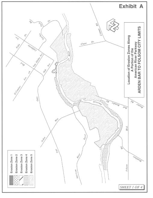
Exhibit B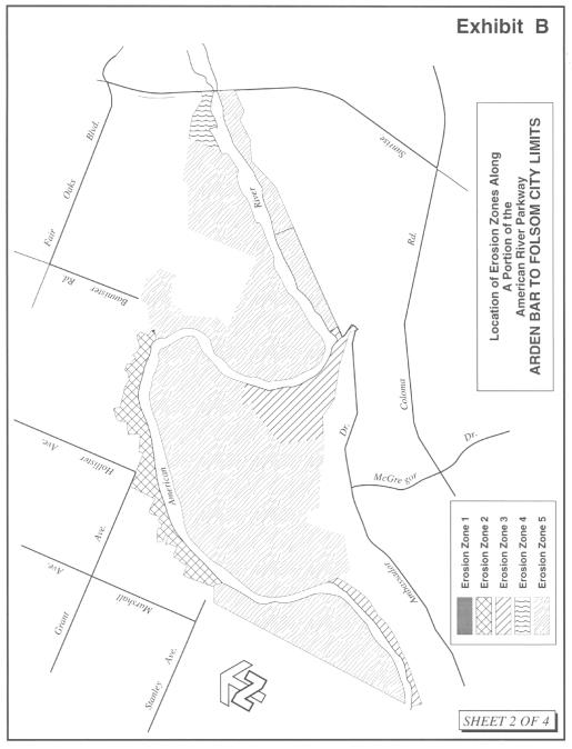
Exhibit C
Exhibit D
M. Proposed Uses within the American River Parkway. Physical improvements and uses within the portion of the American River Parkway located in the city of Rancho Cordova may require ministerial actions (issuance of construction permits) or discretionary approvals (design review) by the city of Rancho Cordova. The procedures and review standards of this subsection shall apply when such city actions are required.
1. Allowed Uses. Prior to granting of any discretionary approval or issuance of any construction permit, the city shall determine if the proposed use is allowed at the proposed location within the American River Parkway. Uses allowed within the American River Parkway shall be those uses generally described in the American River Parkway Plan and more specifically those uses described in the Area Plan in which a proposed use is located. In the event of inconsistencies between allowed uses described in the American River Parkway Plan and other city zoning and land use regulations, the American River Parkway Plan shall govern.
2. Allowed Use Determination. Any application for design review approval or a construction permit for a building, structure or improvement within the American River Parkway shall be reviewed by the director for compliance with the provisions of this chapter and consistency with the American River Parkway Plan. The director may require materials as provided in subsection (J) of this section (Application Requirements) to make a determination.
3. County Consultation. Prior to the director making an allowed use determination, the city shall request and receive a written statement from the county of Sacramento regarding the consistency of the proposed use and/or improvements with the American River Parkway Plan, consistent with subsection (D) of this section (Use of County-Owned Property).
4. Director Determination. The director shall review any application for uses and/or improvements within the American River Parkway for consistency with the American River Parkway Plan. Based upon application materials, consultation with the county of Sacramento and review of the American River Parkway Plan, the director shall determine whether the proposed use and/or improvements are allowed.
5. Director’s Authority. The director may, at his/her discretion, apply requirements, obligations or conditions of approval as described in subsection (G) of this section (Authority of Hearing Body). [Ord. 11-2020 § 3 (Exh. A); Ord. 4-2017 § 3 (Exh. B); Ord. 12-2011 § 3 (Exh. A); Ord. 27-2008 § 1 (Exh. A § 2.9.070)]
23.325.080 Surface mining (SM) overlay zoning district.
A. Purpose and Intent. The city of Rancho Cordova recognizes that the extraction of minerals is essential to the continued economic well-being of the city and to the needs of society and that the reclamation of mined lands is necessary to prevent or minimize adverse effects on the environment and to protect the public health and safety. The city also realizes that surface mining takes place in diverse areas where the geologic, topographic, climatic, biological, and social conditions are significantly different, and the reclamation operations and the specifications therefor may vary accordingly.
The purpose and intent of this section is to ensure the continued availability of important mineral resources, while regulating surface mining operations as required by California’s Surface Mining and Reclamation Act of 1975 (Public Resources Code (PRC) Section 2710 et seq.), as amended, hereinafter referred to as “SMARA” or “the Act,” Public Resources Code Section 2207 (relating to annual reporting requirements), and State Mining and Geology Board regulations (hereinafter referred to as “state regulations”) for surface mining and reclamation practices (California Code of Regulations (CCR), Title 14, Division 2, Chapter 8, Subchapter 1, Section 3500 et seq.), to ensure that:
1. Adverse environmental effects are prevented or minimized and that mined lands are reclaimed to a usable condition which is readily adaptable for alternative land uses.
2. The production and conservation of minerals are encouraged, while giving consideration to values relating to recreation, watershed, wildlife, range and forage, and aesthetic enjoyment.
3. Residual hazards to the public health and safety are eliminated.
B. Definitions. The definitions set forth below shall govern the construction of this section:
1. “Area of regional significance” means an area designated by the State Mining and Geology Board which is known to contain a deposit of minerals, the extraction of which is judged to be of prime importance in meeting future needs for minerals in a particular region of the state within which the minerals are located and which, if prematurely developed for alternate incompatible land uses, could result in the premature loss of minerals that are of more than local significance.
2. “Area of statewide significance” means an area designated by the Board which is known to contain a deposit of minerals, the extraction of which is judged to be of prime importance in meeting future needs for minerals in the state and which, if prematurely developed for alternate incompatible land uses, could result in the permanent loss of minerals that are of more than local or regional significance.
3. “Board” means the State Mining and Geology Board.
4. “Borrow pits” means excavations created by the surface mining of rock, unconsolidated geologic deposits, or soil to provide material (borrow) for fill elsewhere.
5. “Compatible land uses” means land uses inherently compatible with mining and/or that require a minimum public or private investment in structures and land improvements, and which may allow mining because of the relative economic value of the land and its improvements. Examples of such uses may include very low density residential, geographically extensive but low impact industrial, recreational, agricultural, silvicultural, grazing, and open space.
6. “Haul road” means a road along which material is transported from the area of excavation to the processing plant or stock pile area of the surface mining operation.
7. “Idle” means surface mining operations curtailed for a period of one year or more, by more than 90 percent of the operation’s previous maximum annual mineral production, with the intent to resume those surface mining operations at a future date.
8. “Incompatible land uses” means land uses inherently incompatible with mining and/or that require public or private investment in structures, land improvements, and landscaping and that may prevent mining because of the greater economic value of the land and its improvements. Examples of such uses may include high density residential, low density residential with high unit value, public facilities, geographically limited but impact-intensive industrial, and commercial.
9. “Mined lands” means the surface, subsurface, and groundwater of an area in which surface mining operations will be, are being, or have been conducted, including private ways and roads appurtenant to any such area, land excavations, workings, mining waste, and areas in which structures, facilities, equipment, machines, tools, or other materials or property which result from, or are used in, surface mining operations are located.
10. “Minerals” means any naturally occurring chemical element or compound, or group of elements and compounds, formed from inorganic processes and organic substances, including, but not limited to, coal, peat, and bituminous rock, but excluding geothermal resources, natural gas, and petroleum.
11. “Operator” means any person who is engaged in surface mining operations or who contracts with others to conduct operations on his/her behalf, except a person who is engaged in surface mining operations as an employee with wages as his/her sole compensation.
12. “Reclamation” means the combined process of land treatment that maximizes post-mining land uses and minimizes water degradation, air pollution, damage to aquatic or wildlife habitat, flooding, erosion, and other adverse effects from surface mining operations, including adverse surface effects incidental to underground mines, so that mined lands are reclaimed as rapidly as reasonably feasible to an unusable condition which is readily adaptable for alternate land uses and creates no danger to public health or safety. The process may extend to affected lands surrounding mined lands and may require backfilling, grading, resoiling, revegetation, soil compaction, stabilization, or other measures.
13. “Streambed skimming” means excavation of sand and gravel from streambed deposits above the mean summer water level or stream bottom, whichever is higher.
14. “Surface mining operation” means all, or any part of, the process involved in the mining of minerals on mined lands by removing overburden and mining directly from the mineral deposits, open-pit mining of minerals naturally exposed, mining by the auger method, dredging and quarrying, or surface work incident to an underground mine. Surface mining operations include, but are not limited to, in-place distillation or retorting or leaching, the production and disposal of mining waste, prospecting and exploratory activities, borrow pitting, streambed skimming, and segregation and stockpiling of mined materials (and recovery of same).
C. Incorporation by Reference. The provisions of SMARA, PRC Section 2207, and state regulations, as those provisions and regulations may be amended from time to time, are made a part of this section by reference with the same force and effect as if the provisions therein were specifically and fully set out herein, excepting that when the provisions of this chapter are more restrictive than correlative state provisions, this section shall prevail.
D. Scope. Except as provided in this section, no person shall conduct surface mining operations unless a permit, reclamation plan, and financial assurances for reclamation have first been approved by the city. Any applicable exemption from this requirement does not automatically exempt a project or activity from the application of other regulations, ordinances, or policies of the city, including the application of CEQA, the requirement of site approvals or other permits, the payment of development impact fees, or the imposition of other dedications and exactions as may be permitted under the law. The provisions of this section shall apply to all lands within the city, public and private.
This section shall not apply to the following activities, subject to the above-referenced exceptions:
1. Excavations or grading related to agricultural activities or on-site construction or for the purpose of restoring land following a flood or natural disaster.
2. On-site excavation and on-site earthmoving activities which are an integral and necessary part of a construction project that are undertaken to prepare a site for construction of structures, landscaping, or other land improvements, including the related excavation, grading, compaction, and the creation of fills, road cuts, and embankments, whether or not surplus materials are exported from the site, subject to all of the following conditions:
a. All required permits for the construction, landscaping, or related land improvements have been approved by a public agency in accordance with applicable provisions of state law and locally adopted plans and ordinances, including, but not limited to, CEQA (PRC Division 13, Section 21000 et seq.);
b. The city’s approval of the construction project including consideration of the on-site excavation and on-site earthmoving activities pursuant to CEQA;
c. The approved construction project is consistent with the General Plan or zoning of the site; and
d. Surplus materials shall not be exported from the site unless and until actual construction work has commenced and shall cease if it is determined that construction activities have terminated, have been indefinitely suspended, or are no longer being actively pursued.
3. Operation of a plant site used for mineral processing, including associated on-site structures, equipment, machines, tools, or other materials, including the on-site stockpiling and on-site recovery of mined materials, subject to all of the following conditions:
a. The plant site is located on lands designated for industrial or commercial uses in the city’s General Plan.
b. The plant site is located on lands zoned industrial or commercial, or is contained within a zoning category intended exclusively for industrial activities by the city.
c. None of the minerals being processed is being extracted on site.
d. All reclamation work has been completed pursuant to the approved reclamation plan for any mineral extraction activities that occurred on site after January 1, 1976.
4. Prospecting for, or the extraction of, minerals for commercial purposes and removal of overburden in total amounts of less than 1,000 cubic yards in any one location of one acre or less.
5. Surface mining operations that are required by federal law in order to protect a mining claim, if those operations are conducted solely for that purpose.
6. Any other surface mining operations that the State Mining and Geology Board determines to be of an infrequent nature and which involve only minor surface disturbances.
7. Emergency excavations or grading conducted by the Department of Water Resources or the Central Valley Flood Protection Board for the purpose of averting, alleviating, repairing, or restoring damage to property due to imminent or recent floods, disasters, or other emergencies.
8. Road construction and maintenance for timber or forest operations if the land is owned by the same person or entity and if the excavation is conducted adjacent to timber or forest operation roads. This exemption is only available if slope stability and erosion are controlled in accordance with Board regulations and, upon closure of the site, the person closing the site implements, where necessary, revegetation measures and post-closure uses in consultation with the Department of Forestry and Fire Protection. This exemption does not apply to on-site excavation and grading that occurs within 100 feet of a Class One watercourse or 75 feet of a Class Two watercourse, or to excavations for materials that are or have been sold for commercial purposes.
9. Excavations, grading, or other earthmoving activities in an oil or gas field that are integral to, and necessary for, ongoing operations for the extraction of oil or gas that comply with all of the following conditions: (a) the operations are being conducted in accordance with Division 3 (commencing with PRC Section 3000); (b) the operations are consistent with the city’s General Plan and the zoning applicable to the site; (c) the earthmoving activities are within oil or gas field properties under a common owner or operator; and (d) no excavated materials are sold for commercial purposes.
E. Vested Rights. No person who obtained a vested right to conduct surface mining operations prior to January 1, 1976, shall be required to secure a permit to mine, so long as the vested right continues and as long as no substantial changes have been made in the operation except in accordance with SMARA, state regulations, and this section. Where a person with vested rights has continued surface mining operations in the same area subsequent to January 1, 1976, he/she shall obtain city approval of a reclamation plan covering the mined lands disturbed by such subsequent surface mining. In those cases where an overlap exists (in the horizontal and/or vertical sense) between pre- and post-Act mining, the reclamation plan shall call for reclamation proportional to that disturbance caused by the mining after the effective date of the Act (January 1, 1976).
All other requirements of state law and this section shall apply to vested mining operations.
F. Process.
1. Applications for a site approval or reclamation plan for surface mining or land reclamation projects shall be made on forms provided by the department. Said application shall be filed in accord with this section and procedures to be established by the director. The forms for reclamation plan applications shall require, at a minimum, each of the elements required by SMARA (PRC Sections 2772 through 2773) and state regulations, and any other requirements deemed necessary to facilitate an expeditious and fair evaluation of the proposed reclamation plan, to be established at the discretion of the director. As many copies of the site approval application as may be required by the director shall be submitted to the department.
2. As many copies of a reclamation plan application as may be required shall be submitted in conjunction with all applications for site approvals for surface mining operations. For surface mining operations that are exempt from a site approval pursuant to this section, the reclamation plan application shall include information concerning the mining operation that is required for processing the reclamation plan. All documentation for the reclamation plan shall be submitted to the city at one time.
3. Applications shall include all required environmental review forms and information prescribed by the director.
4. Upon completion of the environmental review procedure and filing of all documents required by the director, consideration of the site approval or reclamation plan for the proposed or existing surface mine shall be completed pursuant to this section at a public hearing before the council and pursuant to PRC Section 2774.
5. The reclamation plan shall be applicable to a specific property or properties and shall be based upon the character of the surrounding area and such characteristics of the property as the type of overburden, vegetation, soil stability, topography, geology, climate, stream characteristics, and principal mineral commodities.
6. All reclamation plans shall contain, at a minimum, the following information and documents:
a. The estimated time schedule for the beginning and completion of reclamation activities. If the mining operation is to be accomplished in phases, the time schedule shall indicate the estimated beginning and completion of reclamation activities for each phase.
b. An estimate of the cost of completion of reclamation activities, computed at current cost at the time proposed in the time schedule submitted for completion of the reclamation plan.
c. A description of the existing vegetation at and surrounding the site.
d. A general description of the geology of the surrounding area and a detailed description of the geology at the reclamation site.
e. A description of the proposed use or potential uses of land after reclamation, and evidence that all owners of a possessory interest in the land have been notified of the proposed use or potential uses.
f. A description of the manner in which reclamation, adequate for the proposed use or potential uses, will be accomplished, including:
i. The manner in which mining wastes and related contaminants will be controlled and disposed of.
ii. The manner in which affected streambed channels and stream banks will be rehabilitated to a condition minimizing erosion and sedimentation.
g. An assessment of the effect of implementation of the reclamation plan on future mining in the area.
h. A statement by the applicant that he/she accepts responsibility for reclaiming mined lands in accordance with the approved reclamation plan.
i. A statement by the applicant that he/she accepts responsibility for all completed reclamation work for a period of two years or such greater period as deemed necessary by the council to ensure the permanency of all features of the reclamation plan. This subsection shall not apply to normal maintenance and repairs unrelated to the reclamation work on public facilities where dedicated to and accepted by the city of Rancho Cordova.
j. Such other information as the department may require.
k. The department may waive the filing of one or more of the above items where it is determined unnecessary to process the application subject to the provisions of this chapter.
7. Additional information may be required per a department form. Where a reclamation plan is not filed as a part of a surface mining permit, such plan shall be accompanied by an application for separate reclamation plan approval which contains the following information:
a. The names and addresses of the applicant and the mining operator, if different, and of any persons designated by the applicant as his agents for service of process.
b. The names and addresses of all persons owning a possessory and/or mineral interest in any or all of the property to be used for mining operations.
8. The department may deny, without a public hearing, an application for a reclamation plan if such application or plan does not contain the information required in subsection (F)(6) of this section. The department may permit the applicant to amend such application.
9. Within 10 days of acceptance of an application as complete for a site approval for surface mining operations and/or a reclamation plan, the department shall notify the California Department of Conservation of the filing of the application(s). Whenever mining operations are proposed in the 100-year floodplain of any stream, as shown in Zone A of the flood insurance rate maps issued by the Federal Emergency Management Agency, and within one mile, upstream or downstream, of any state highway bridge, the department shall also notify the California Department of Transportation that the application has been received.
10. The department shall process the application(s) through environmental review pursuant to CEQA (PRC Section 21000 et seq.) and the city’s environmental review guidelines.
11. Subsequent to the appropriate environmental review, the department shall prepare a staff report with recommendations for consideration by the council.
12. The council shall hold at least one noticed public hearing on site approval and/or reclamation plan.
13. Prior to final approval of a reclamation plan, financial assurances (as provided in this section), or any amendments to the reclamation plan or existing financial assurances, the council shall certify to the California Department of Conservation that the reclamation plan and/or financial assurance complies with the applicable requirements of state law, and submit the plan, assurance, or amendments to the California Department of Conservation for review. The council may conceptually approve the reclamation plan and financial assurance before submittal to the California Department of Conservation. If a site approval is being processed concurrently with the reclamation plan, the council may simultaneously also conceptually approve the site approval. However, the council may defer action on the site approval until taking final action on the reclamation plan and financial assurances. If necessary to comply with permit processing deadlines, the council may conditionally approve the site approval with the condition that the department shall not issue the site approval for the mining operations until cost estimates for financial assurances have been reviewed by the California Department of Conservation and final action has been taken on the reclamation plan and financial assurances.
Pursuant to PRC Section 2774(d), the California Department of Conservation shall be given 30 days to review and comment on the reclamation plan and 45 days to review and comment on the financial assurance. The council shall evaluate written comments received, if any, from the California Department of Conservation during the comment periods. Staff shall prepare a written response describing the disposition of the major issues raised by the state for the council’s approval. In particular, when the council’s position is at variance with the recommendations and objections raised in the state’s comments, the written response shall address, in detail, why specific comments and suggestions were not accepted. Copies of any written comments received and responses prepared by the council shall be promptly forwarded to the operator/applicant.
14. The council shall then take action to approve, conditionally approve, or deny the site approval and/or reclamation plan, and to approve the financial assurances pursuant to PRC Section 2770(d).
15. The department shall forward a copy of each approved site approval for mining operations and/or approved reclamation plan, and a copy of the approved financial assurances, to the California Department of Conservation. By July 1st of each year, the department shall submit to the California Department of Conservation for each active or idle mining operation a copy of the site approval or reclamation plan amendments, as applicable, or a statement that there have been no changes during the previous year.
G. Standards for Reclamation.
1. All reclamation plans shall comply with the provisions of SMARA (Sections 2772 and 2773) and state regulations (CCR Sections 3500 through 3505). Reclamation plans approved after January 15, 1993, reclamation plans for proposed new mining operations, and any substantial amendments to previously approved reclamation plans shall also comply with the requirements for reclamation performance standards (CCR Sections 3700 through 3713).
2. The city may impose additional performance standards, including without limitation standards beyond those cited to make the findings in this chapter, as developed either in review of individual projects, as warranted, or through the formulation and adoption of citywide performance standards.
3. Reclamation activities shall be initiated at the earliest possible time on those portions of the mined lands that will not be subject to further disturbance. Interim reclamation may also be required for mined lands that have been disturbed and that may be disturbed again in future operations or in connection with approved or proposed development. Reclamation may be done on an annual basis, in stages compatible with continuing operations, or on completion of all excavation, removal, or fill, as approved by the city. Each phase of reclamation shall be specifically described in the reclamation plan and shall include (a) the beginning and expected ending dates for each phase; (b) all reclamation activities required; (c) criteria for measuring completion of specific reclamation activities; and (d) estimated costs for completion of each phase of reclamation.
4. Unless otherwise specified in the approved reclamation plan, the reclamation of mined lands shall be carried out in accordance with the following requirements:
a. Reclamation Timing.
i. The reclamation of mined lands shall occur as soon as practical following completion of mining operations at successive locations within the mining site as required by the schedule in the approved reclamation plan.
ii. The reclamation of lands affected by surface mining operations shall be completed within one year of the completion of mining operations, except where the permanent reclaimed condition of mined lands cannot be achieved within one year due to the regulatory approvals (e.g., compliance with CEQA) required for the ultimate land use contemplated or proposed for the property (e.g., urban development). In such case, only interim reclamation, pursuant to this chapter, need be accomplished within one year, and final reclamation shall be completed as soon as it is possible to complete the reclamation in compliance with the above regulatory approvals, but in no case shall reclamation take more than three years.
b. Disposal of Overburden and Mining Waste.
i. Permanent piles or dumps of overburden and waste rock placed on the land shall be made stable, shall not restrict natural drainage without provision for diversion, and shall have an overall smooth or even profile subject to the satisfaction of the city engineer. Where practical, such permanent piles or dumps shall be located in the least visible location at the mining site.
ii. Old equipment and inert mining wastes shall be removed or buried subject to the approval of the hearing officer.
iii. Toxic materials shall be removed from the site or permanently protected to prevent leaching into the underlying groundwater, to the satisfaction of the department.
iv. Overburden and mining waste placed beneath the existing or potential groundwater level which will reduce the transmissivity or area through which water may flow shall be confined to an area approved by the city engineer.
c. Revegetation.
i. All permanently exposed lands that have been denuded by mining operations shall be revegetated to provide ground cover sufficient to control erosion from such lands.
ii. All plantings shall be established and maintained in good horticultural condition. The revegetation shall be able to survive under natural conditions, with native species used whenever possible.
iii. Revegetation methods shall take into account the topography and existing growth patterns and mixes of flora present at and adjacent to the site of mining operations in order to create a more natural appearance. Plantings shall avoid rigid, geometric patterns and shall utilize natural scatterings.
iv. Where the ultimate intended or proposed use of mined lands would be a level of development inconsistent with extensive permanent vegetation, the amount of vegetation required for reclamation need not be more than is sufficient to prevent erosion.
d. Resoiling.
i. Resoiling measures shall take into consideration the quality of soils which may be required to sustain plant life pursuant to any revegetation that the hearing officer may require in its approval of the applicant’s reclamation plan.
ii. Coarse, hard material shall be graded and covered with a layer of finer material or weathered waste. A soil layer shall then be placed on this prepared surface. Where quantities of available soils are inadequate to provide cover, native materials shall be upgraded to the extent feasible for this purpose.
e. Final Slopes.
i. Final slopes shall be engineered and contoured so as to be geologically stable, to control the drainage therefrom, and to blend with the surrounding topography where practical. On the advice of the city engineer, the department may require the establishment of terrace drains to control drainage and erosion.
ii. Final slopes shall not be steeper than two feet horizontal to one foot vertical unless the applicant can demonstrate to the department’s satisfaction that a steeper slope will not:
(A) Reduce the effectiveness of revegetation and erosion control measures where they are necessary; and
(B) Be incompatible with the alternate future uses approved by the council for the site; and
(C) Be hazardous to persons that may utilize the site under the alternate future uses approved for the site.
f. Drainage, Erosion, and Sediment Control.
i. Any temporary stream or watershed diversion shall be restored to its state prior to any surface mining activities unless the department deems otherwise based on recommendations from the city engineer.
ii. Streambed channels and stream banks affected by surface mining shall be rehabilitated to a condition which would minimize erosion and sedimentation, except that such rehabilitation need not attempt to restore or mimic natural conditions where the contemplated or proposed ultimate use of the reclaimed property would be inconsistent with the maintenance of restored or rehabilitated streambed channels and stream banks.
iii. Revegetation and regrading techniques shall be designed and executed so as to minimize erosion and sedimentation. Drainage shall be provided to natural outlets or interior basins designed for water storage, with such basins subject to the approval of the city engineer. In addition, final excavation shall eliminate potholes and similar catchments so as to prevent potential breeding areas for mosquitoes.
iv. The final grading and drainage of the site shall be designed in a manner to prevent discharge of sediment above natural levels existent prior to mining operations.
v. Silt basins which will store water during periods of surface runoff shall be equipped with sediment control and removal facilities and protected spillways designed to minimize erosion when such basins have outlet to lower ground.
vi. No condition shall remain after reclamation which will or could lead to degradation of groundwater quality below applicable standards of the regional water quality control board or any other agency with jurisdiction over water quality.
g. Backfilling and Grading.
i. Subject to the approval of the city engineer, backfilled and graded areas shall be compacted to avoid excessive settlement and to the degree necessary to accommodate anticipated future uses.
ii. Materials used in the refilling shall be of a quality suitable to prevent contamination and/or pollution of groundwater. If materials for backfilling and grading are obtained from an area other than the site of surface mining operations, such materials shall be included and the approximate quantities identified in the applicant’s reclamation plan.
h. Reservoirs, ponds, lakes, or any body of water created as a feature of the reclamation plan shall be approved by the city engineer and the department.
i. The periodic review of the conditions contained in approved reclamation plans shall be conducted by the department in accordance with the schedule adopted at the time such plans were approved. At the time of approval of a permit to mine, the city shall determine whether future public hearings are necessary to consider such new or changed circumstances as physical development near the mining site and improved technological innovations in the field of reclamation which may significantly improve the reclamation process. The city may set a term for such reviews on a case-by-case basis as a condition of the permit if it deems such a review to be necessary. Should a permit be modified pursuant to such a review, the modified permit and/or reclamation plan shall be binding upon the operator and all successors, heirs, and assigns of the applicant.
H. Statement of Responsibility. The person submitting the reclamation plan shall sign a statement accepting responsibility for reclaiming the mined lands in accordance with the reclamation plan. Said statement shall be kept by the department in the mining operation’s permanent record. Upon sale or transfer of the operation, the new operator shall submit a signed statement of responsibility to the department for placement in the permanent record.
I. Findings for Approval.
1. Site Approvals. In addition to any findings required by this section, site approvals for surface mining operations shall include a finding that the project complies with the provisions of SMARA and state regulations.
2. Reclamation Plans. For reclamation plans, the following findings shall be required:
a. That the reclamation plan complies with SMARA Sections 2772 and 2773 and any other applicable provisions.
b. That the reclamation plan complies with applicable requirements of state regulations (CCR Sections 3500 through 3505 and 3700 through 3713).
c. That the reclamation plan will restore the mined lands to a usable condition that is readily adaptable for alternative land uses that are consistent with this section and either (i) the city’s General Plan and any applicable resource plan or element, or (ii) probable future uses anticipated by the city to be adopted in future amendments to the city’s General Plan, which uses are identified in findings made on approval of the reclamation plan.
d. That the reclamation plan has been reviewed pursuant to CEQA and the city environmental review guidelines, and any significant adverse impacts from reclamation of the surface mining operations are mitigated to the extent feasible.
e. That the land and/or resources such as water bodies to be reclaimed will be restored to a condition that is compatible with, and blends in with, the surrounding natural environment, topography, and other resources, or that suitable off-site development will compensate for related disturbance to resource values.
f. That a written response to the California Department of Conservation has been prepared, describing the disposition of major issues raised by that department. Where the city’s position is at variance with the recommendations and objections raised by the California Department of Conservation, said response shall address, in detail, why specific comments and suggestions were not accepted.
J. Financial Assurances.
1. To ensure that the reclamation will proceed in accordance with the approved reclamation plan, the city shall require as a condition of approval security in the form of a surety bond, trust fund, or irrevocable letter of credit from an accredited financial institution, or other method acceptable to the city and the State Mining and Geology Board as specified in state regulations, and which the city reasonably determines is adequate to perform reclamation in accordance with the surface mining operation’s approved reclamation plan. Financial assurances shall be made payable to the city of Rancho Cordova and the California Department of Conservation.
2. Financial assurance will be required to ensure compliance with elements of the reclamation plan, including revegetation and landscaping requirements, restoration of aquatic or wildlife habitat, restoration of water bodies and water quality, slope stability and erosion and drainage control, disposal of hazardous materials, and other measures, if necessary.
3. Cost estimates for the financial assurance shall be submitted to the department for review and approval prior to the operator securing financial assurances. The director shall forward a copy of the cost estimates, together with any documentation received supporting the amount of the cost estimates, to the California Department of Conservation for review. If the California Department of Conservation does not comment within 45 days of receipt of these estimates, it shall be assumed that the cost estimates are adequate, unless the city has reason to determine that additional costs may be incurred. The director shall have the discretion to approve the financial assurance, if it meets the requirements of this section, SMARA, and state regulations.
4. The amount of the financial assurance shall be based upon the estimated costs of reclamation for the years or phases stipulated in the approved reclamation plan, including any maintenance of reclaimed areas as may be required, subject to adjustment for the actual amount required to reclaim lands disturbed by surface mining activities necessary to implement the approved reclamation plan, the unit costs for each of these activities, the number of units of each of these activities, and the actual administrative costs. Financial assurances to ensure compliance with revegetation, restoration of water bodies, restoration of aquatic or wildlife habitat, and any other applicable element of the approved reclamation plan shall be based upon cost estimates that include but may not be limited to labor, equipment, materials, mobilization of equipment, administration, and reasonable profit by a commercial operator other than the permittee. A contingency factor of 10 percent shall be added to the cost of the financial assurance.
5. In projecting the costs of financial assurances, it shall be assumed without prejudice or insinuation that the surface mining operation could be abandoned by the operator and, consequently, the city or California Department of Conservation may need to contract with a third-party commercial company for reclamation of the site.
6. The financial assurances shall remain in effect for the duration of the surface mining operation and any additional period until reclamation is completed (including any maintenance required).
7. The amount of financial assurances required of a surface mining operation for any one year shall be adjusted annually to account for new lands disturbed by surface mining operation, inflation, and reclamation of lands accomplished in accordance with the approved reclamation plan. The financial assurances shall include estimates to cover reclamation for existing conditions and anticipated activities during the upcoming year, excepting that the permittee may not claim credit for reclamation scheduled for completion during the coming year.
8. Revisions to financial assurances shall be submitted to the director each year prior to the anniversary date for approval of the financial assurances. The financial assurance shall cover the cost of existing disturbance and anticipated activities for the next calendar year, including any required interim reclamation. If revisions to the financial assurances are not required, the operator shall explain, in writing, why revisions are not required.
K. Interim Management Plans.
1. Within 90 days of a surface mining operation becoming idle, the operator shall submit to the department a proposed interim management plan (IMP). The proposed IMP shall fully comply with the requirements of SMARA, including but not limited to all site approval conditions, and shall provide measures the operator will implement to maintain the site in a stable condition, taking into consideration public health and safety. The proposed IMP shall be submitted on forms provided by the department and shall be processed as an amendment to the reclamation plan. IMPs shall not be considered projects for the purposes of environmental review.
2. Financial assurances for idle operations shall be maintained as though the operation were active.
3. Upon receipt of a complete proposed IMP, the department shall forward the IMP to the California Department of Conservation for review. The IMP shall be submitted to the California Department of Conservation at least 30 days prior to approval by the council.
4. Within 60 days of receipt of the proposed IMP, or a longer period as mutually agreed upon by the director and the operator, the council shall review and approve or deny the IMP in accordance with this section. The operator shall have 30 days, or a longer period as mutually agreed upon by the director and the operator, to submit a revised IMP. The council shall approve or deny the revised IMP within 60 days of receipt.
5. The IMP may remain in effect for a period not to exceed five years, at which time the council may renew the IMP for another period not to exceed five years or require the surface mining operator to commence reclamation in accordance with its approved reclamation plan.
L. Annual Report Requirements. Surface mining operators shall forward an annual surface mining report to the California Department of Conservation and to the city department on a date established by the California Department of Conservation, on forms furnished by the State Mining and Geology Board. New mining operations shall file an initial surface mining report and any applicable filing fees with the California Department of Conservation within 30 days of permit approval or before commencement of operations, whichever is sooner. Any applicable fees, together with a copy of the annual inspection report, shall be forwarded to the California Department of Conservation at the time of filing the annual surface mining report.
M. Inspections. The department shall arrange for inspection of a surface mining operation within six months of receipt of the annual report required in subsection (L) of this section (Annual Report Requirements) to determine whether the surface mining operation is in compliance with the approved site approval and/or reclamation plan, approved financial assurances, and state regulations. In no event shall less than one inspection be conducted in any calendar year. Said inspections may be made by a state-registered geologist, state-registered civil engineer, state-licensed landscape architect, or state-registered forester who is experienced in land reclamation and who has not been employed by the mining operation in any capacity during the previous 12 months, or other qualified specialists, as selected by the director. All inspections shall be conducted using a form approved and provided by the State Mining and Geology Board.
The department shall notify the California Department of Conservation within 30 days of completion of the inspection that said inspection has been conducted and shall forward a copy of said inspection notice and any supporting documentation to the mining operator. The operator shall be solely responsible for the reasonable cost of such inspection.
N. Violations and Penalties. If the director, based upon an annual inspection or otherwise confirmed by an inspection of the mining operation, determines that a surface mining operation is not in compliance with this section, the applicable site approval, any required permit, and/or the reclamation plan, the city shall follow the procedures set forth in PRC Sections 2774.1 and 2774.2 concerning violations and penalties, as well as those provisions of the city development code for revocation and/or abandonment of site approval which are not preempted by SMARA.
O. Appeals. Any person aggrieved by an act or determination of the department in the exercise of the authority granted herein shall have the right to appeal to the council. An appeal shall be filed on forms provided, within 15 calendar days after the rendition, in writing, of the appealed decision.
P. Fees. The city shall establish such fees as it deems necessary to cover the reasonable costs incurred in implementing this section and the state regulations, including, but not limited to, processing of applications, annual reports, inspections, monitoring, enforcement, and compliance. Such fees shall be paid by the operator, as required by the city, at the time of filing of the site approval application, reclamation plan application, and at such other times as are determined by the city to be appropriate in order to ensure that all reasonable costs of implementing this section are borne by the mining operator.
Q. Mineral Resource Protection. Mine development is encouraged in compatible areas before encroachment of conflicting uses. Except as provided by PRC Section 2763, mineral resource areas that have been classified by the California Department of Conservation’s Division of Mines and Geology or designated by the State Mining and Geology Board, as well as existing surface mining operations that remain in compliance with the provisions of this section, shall be protected from the intrusion by incompatible land uses that may impede or preclude mineral extraction or processing, to the extent possible for consistency with the city’s General Plan.
In accordance with PRC Section 2762, the city’s General Plan and resource maps will be prepared to reflect mineral information (classification and/or designation reports) within 12 months of receipt from the State Mining and Geology Board of such information. Land use decisions within the city will be guided by information provided on the location of identified mineral resources of regional significance. Conservation and potential development of identified mineral resource areas will be considered and encouraged. Recordation on property titles of the presence of important mineral resources within the identified mineral resource areas may be encouraged as a condition of approval of any development project in the impacted area. Prior to approving a use that would otherwise be incompatible with mineral resource protection, conditions of approval may be applied to encroaching development projects to minimize potential conflicts. [Ord. 4-2017 § 3 (Exh. B); Ord. 13-2013 § 4 (Exh. B); Ord. 12-2011 § 3 (Exh. A); Ord. 27-2008 § 1 (Exh. A § 2.9.080)].
23.325.090 Sunridge general commercial (SGC) overlay zoning district.
A. Purpose and Intent. The purpose of the Sunridge general commercial (SGC) overlay is to ensure commercial development sites will be available to meet the retail and commercial demands of residents in the southern portion of the city. The SGC overlay district is intended to provide ample opportunity for a variety of community serving commercial endeavors while limiting those land uses that may detract from successful retail, grocery, and restaurant users. Where there is a conflict between this overlay district and the underlying base district, the overlay district regulations prevail.
B. The Sunridge general commercial overlay zoning district is applied to those parcels described in Figure 23.325-8 (Sunridge General Commercial Overlay District). The district is generally defined as those parcels zoned general commercial (GC) located south of Douglas Road within the Sunridge Specific Plan Area.
C. The SGC overlay shall expire January 14, 2022, unless the council approves an extension of the SGC overlay district.
Figure 23.325-8 Sunridge General Commercial Overlay District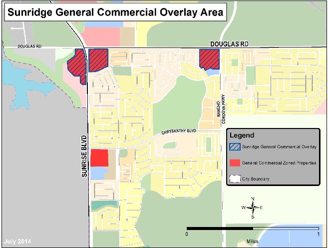
D. Allowed Uses. The permitted uses in the GC zone are set forth in Table 23.316-1, Allowed Use and Permit Requirements for General Commercial and Industrial Zoning Districts, except that in the SGC overlay zone the following additional restrictions apply:
|
Land Use Category |
Sunridge General Commercial Overlay Zoning District1 |
|---|---|
|
Dwelling, Multifamily |
N/P |
|
Recreational Vehicle Parks |
N |
|
Equipment Sales and Rental |
C |
|
Maintenance and Repair, Small Equipment |
C |
|
Auto and Vehicle Sales |
C |
|
Auto and Vehicle Rental |
C |
|
Auto and Vehicle Storage |
N |
|
Vehicle Services, Major |
C |
|
Vehicle Services, Minor |
C |
|
Manufacturing, Small Scale |
C |
|
Storage, Warehouse |
N |
|
Wholesaling and Distribution |
N |
|
1 No residential development will be allowed on properties within the SGC overlay until 180,000 square feet of predominantly retail commercial development is built on GC-zoned properties identified on Figure 23.325-8; such development must include a neighborhood grocery store. Once 180,000 square feet of predominantly retail commercial development (including a grocery store) has been constructed upon one or more of the GC sites identified on Figure 23.325-8, residential development would be allowed by right on remaining SGC overlay sites, subject to the regulations of the GC zoning district. |
|
[Ord. 4-2017 § 3 (Exh. B); Ord. 23-2014 § 3 (Exh. A)].