


Chapter 18.14
STREAM DEVELOPMENT AND MAINTENANCE (SDM) OVERLAY DISTRICT
Sections:
18.14.030 Stream setback requirements.
18.14.040 Dedication of drainage and scenic easements.
18.14.010 Purpose.
This Stream Development and Maintenance (SDM) Overlay District is intended to protect waterways and the health, safety and welfare of residents of the City by establishing regulations for development adjacent to creeks. The specific purposes of the SDM Overlay District are to:
A. Preserve and protect the natural hydrological system and ecological functions of waterways;
B. Provide reasonable protection to owners of riparian property and the public from the hazards of stream bank failures and flooding, while allowing owners of property near waterways reasonable use of and the opportunity to improve their properties consistent with general safety; and
C. Avoid excavation, filling, development, or construction that could adversely affect public health and safety by aggravating drainage flows during flooding conditions or interfering with riparian habitat. (Ord. 1438 § 4 (Exh. A (part)), 2011)
18.14.020 Applicability.
The provisions of this chapter shall apply to all lots and sites where any portion of the property is within twenty-five feet of top of bank of Cordilleras, Belmont, Brittan and Pulgas Creeks within the City. These regulations may be combined with any district. In the event of a conflict between the provisions of this chapter and any underlying base district, the most restrictive provisions shall apply. (Ord. 1438 § 4 (Exh. A (part)), 2011)
18.14.030 Stream setback requirements.
A. Required Setback. All new development shall be set back a minimum twenty-five feet from the top of bank line or such other distance as specified by the Planning and Transportation Commission.
1. Development. For the purposes of this chapter, development is as defined in Chapter 18.41, Terms and Definitions, and includes structures, buildings of any type, swimming pools, driveways, streets, parking areas, patios, platforms, decks, liquid storage tanks, and broken concrete rubble, earth fill or other structural debris or fill. Retaining walls or channel lining to prevent erosion of the creek bank shall be allowed, but shall be subject to Federal and State permits and a building permit. Fences pursuant to Section 18.15.040, Fences and Walls, shall be allowed.
2. Top of Bank Line. Top of bank line is determined as follows:
a. Waterway with Defined Bank. Top of bank line is the line connecting all the points where there is substantial grade change between the creek bank and the property as determined by the applicant’s engineer and subject to the review and approval of the City Engineer.
b. Waterway without Defined Bank. Where there is no defined bank and the slope from the streambed is less than 2:1, top of bank is considered the one-hundred-year storm surface elevation established in the most recent flood insurance study for the City of San Carlos or the water surface elevation as calculated by the applicant’s engineer and subject to the review and approval of the City Engineer.
c. Channelized Waterway. Where a fully channelized waterway exists, top of bank is the highest edge of the engineered channel.
FIGURE 18.14.030-A(2): TOP OF BANK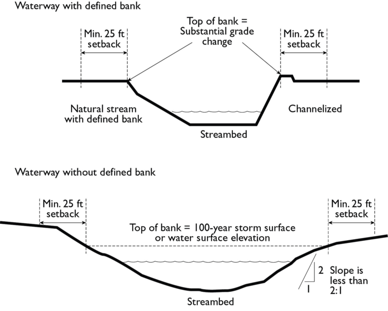
B. Exceptions. The only activities allowed within the required setback are those related to storm drainage, erosion control, and streambank stability improvements that comply with the following standards and have been approved, as required by law, by the governmental agencies having jurisdiction over them:
1. Storm drain outflows and the associated drainage facilities shall be designed so as to eliminate or minimize increases in the rate and amount of stormwater discharge.
2. Vegetation shall not be cut or removed except for normal maintenance, to facilitate drainage, prevent flooding, and to permit adequate flow of water. Such cutting or removal of vegetation shall be limited to the minimum amount necessary, with special care to avoid removal of vegetation immediately adjacent to the banks of the stream.
3. Fill, grading, or excavating for purposes of low intensity, passive recreation or conservation uses may be allowed with conditional use permit approval. Such activities shall be kept to the minimum amount necessary to accomplish its aims and designed and executed so as to minimize erosion, sedimentation or runoff in or into the stream channel.
4. Minor restoration or maintenance necessary to prevent flooding, reduce siltation, remove debris, and minor weed abatement activity necessary to protect life or property or otherwise provide for the public health and safety may be approved by the City.
5. Except in the case of emergency, all development, grading, restoration and maintenance shall be confined to the dry months (April 15th to October 15th) and all erodible slopes and surfaces exposed by such work will be hydromulched or secured by equally effective erosion control prior to October 15th to the satisfaction of the City Engineer. (Ord. 1612 § 1 (Exh. A), 2024; Ord. 1443 § 4 (Exh. A (part)), 2012; Ord. 1438 § 4 (Exh. A (part)), 2011)
18.14.040 Dedication of drainage and scenic easements.
The City may, as a condition of a development permit or subdivision, require the dedication of a drainage and/or scenic easement over and maintenance, in its natural condition or existing state, of each stream channel within the top of each bank or such other distance as specified by the review authority to avoid excavation, filling, development or construction that could adversely affect the public health and safety by aggravating drainage flows during flooding conditions or interfering with the streamside habitat. (Ord. 1438 § 4 (Exh. A (part)), 2011)