


SAFETY ELEMENT
1.0 Introduction
1.1 Overview
1.1.1 Contents of Element
This safety element identifies existing conditions and issues involving potential hazards and public safety considerations affecting land development in Solana Beach. This element also sets forth goals, objectives, and policies to provide for public health, safety, and welfare.
1.1.2 Key Issues
The key issues affecting the health and safety of Solana Beach’s residents and visitors are hazards associated with seismicity, coastal bluff erosion and stability problems, flooding in the Stevens Avenue area south of Nardo Avenue, potential septic system problems, and potential fire hazards. These and other public safety issues are described in Section 2.0 of this element.
1.1.3 Overview of Goals, Objectives, and Policies
The goals of this element are to minimize potential hazards and to provide a safe and secure environment for the public. To achieve these goals, a comprehensive set of objectives and policies is established. These objectives and policies involve specific measures and programs to ensure that potential risks are minimized or avoided during the development process. Further, these objectives and policies provide the framework for ensuring the city’s ability to respond adequately to emergencies.
1.2 Purpose
This safety element is intended to document potential hazards that must be considered in planning the location, type, and density of development. By identifying the nature and location of potential hazards, the city of Solana Beach has been able to adopt a Land Use Plan that reflects such hazards and has been able to establish appropriate programs to prevent or minimize death, injuries, damage to property, and economic and social dislocation resulting from public safety hazards.
1.3 Authorization
Government Code Section 65302(g) requires the adoption of a safety element to protect the public from unreasonable risks associated with seismic hazards, geologic hazards, flooding, fire, and other public safety hazards.
2.0 Existing Conditions/Issue Analysis
2.1 Geologic and Seismic Hazards
2.1.1 Seismic Setting
Solana Beach is located on the western edge of the Peninsular Range geologic province. The Peninsular Range province is a physiographic feature which includes the Laguna Mountains, the Agua Tibia Mountains, the Santa Rosa Mountains, the San Jacinto Mountains, and the Santa Ana Mountains. The formation of this province’s mountain ranges and other features is due to the relative movement of the Pacific and North American continental plates along the San Andreas fault system. The province is located immediately west of the San Andreas fault and is affected by a number of other faults.
Solana Beach, like much of southern California, is located in a region of high seismic activity. Table 1 summarizes the key features of faults located in the San Diego region that could affect Solana Beach.
|
Fault Name |
Fault Length (miles) |
Estimated Magnitude of Maximum Credible Earthquake |
|
San Andreas |
650 |
8.4 |
|
Elsinore |
135 |
7.6 |
|
San Jacinto |
125 |
7.8 |
|
San Clemente |
110 |
7.7 |
Source: County of San Diego, Seismic Safety Element – San Diego County General Plan, January 1975.
In addition to the faults listed on Table 1, an offshore extension of the Rose Canyon fault lies approximately two miles to the west of Solana Beach. This fault is considered to be potentially active, meaning that evidence exists for movement within this zone during the Pleistocene age (two million to 11,000± years ago) but not during the Holocene age (last 11,000± years). Events are much less likely to occur on potentially active faults as compared to active faults. However, given the close proximity of the Rose Canyon fault to Solana Beach, a strong earthquake on this fault could produce severe ground shaking in the city. In addition, recent offshore seismic activity has demonstrated that small magnitude earthquakes (less than 4.5 magnitude) can be generated on offshore faults, located approximately five miles offshore, and known as the South Coast Offshore Zone of Deformation.1
Historically, earthquakes less than magnitude 4 have been common to the San Diego region. However, the probability of a magnitude 6 or greater earthquake being generated locally in the San Diego area is considered low based on present knowledge.2
2.1.2 Geologic and Seismic Constraints to Development
The suitability of land for development is influenced strongly by the presence of certain geologic and seismic hazards. These hazards range from the direct and indirect effects associated with earthquakes to problems associated with slope stability and soil conditions that are not conducive to development. The general nature of various geologic and seismic constraints to development and their applicability to Solana Beach are described below.
SEISMIC SHAKING
The energy released by movement along a fault travels through the earth’s crust as shock waves which cause the ground motion associated with earthquakes. The severity of ground motion at any given location is related to the total amount of energy released, the distance from the earthquake’s origin, and the character of surface and subsurface geologic conditions.
A commonly used method of measuring the severity of ground motion involves estimating maximum ground acceleration. Acceleration is defined as the increased velocity given to the ground by shock waves passing through the geologic structure. Acceleration is typically described in terms of gravitational force where one unit of gravitational force (designated as “1g”) is equal to 9.8 meters/sec2.
The degree of ground acceleration is a function of underlying geologic materials. As shock waves pass through loose, unconsolidated geologic materials, the amplitude of the waves is greater than that associated with dense, consolidated materials (e.g., hillside areas). Thus, the higher amplitude of shock waves results in greater ground acceleration in areas underlain by alluvial soils or water-saturated sediments.
Virtually all of Solana Beach consists of well-consolidated geologic materials rather than poorly consolidated soils such as alluvial deposits. Nevertheless, it should be noted that ground shaking in hillside areas could induce the slumping of geologic structures or landslides in areas of slope instability.
One method of measuring the effects of seismic shaking at specific locations is through use of the Modified Mercalli Scale. As shown on Table 2, this scale represents the classification of an earthquake’s effects according to 12 categories ranging from “not felt” to “damage nearly total.” This is a subjective scale in that an earthquake’s intensity is measured in relation to its effect on human life. According to the California Division of Mines and Geology, Solana Beach is within an area where the intensity of maximum expectable earthquakes would likely be moderate. Thus, the probable maximum intensity of an earthquake in the San Diego area would rank as a VII or VIII on the Modified Mercalli Scale.3
|
A subjective measure of the force of an earthquake at a particular place as determined by its effects on persons, structures, and earth materials. The principal scale used in the United States today is the Modified Mercalli, 1956 verson as defined below (modified from Richter, 1958). |
|
|
I. Not felt. |
II. Felt by persons at rest, on upper floors, or favorably placed. |
|
III. Felt indoors. Hanging objects swing. Vibration like passing of light trucks. Duration estimated. May not be recognized as an earthquake. |
IV. Hanging objects swing. Vibration like passing of heavy trucks; or sensation of a jolt like a heavy ball striking the walls. Standing automobiles rock. Windows, dishes, doors rattle. Wooden walls and frame may creak. |
|
V. Felt outdoors; direction estimated. Sleepers wakened. Liquids disturbed, some spilled. Small unstable objects displaced or upset. Doors swing. Shutters, pictures move. Pendulum clocks stop, start, change rate. |
VI. Felt by all. Many frightened and run outdoors. Persons walk unsteadily. Windows, dishes, glassware broken. Knickknacks, books, etc., off shelves. Pictures off walls. Furniture moved or overturned. Weak plaster and masonry D1 cracked. |
|
VII. Difficult to stand. Noticed by drivers of automobiles. Hanging objects quiver. Furniture broken. Weak chimneys broken at roof line. Damage to masonry D, including cracks; fall of plaster, loose bricks, stones, tiles, and unbraced parapets. Small slides and carving in along sand or gravel banks. Large bells ring. |
VIII. Steering of automobiles affected. Damage to masonry C; partial collapse. Some damage to masonry B; none to masonry A. Fall of stucco and some masonry walls. Twisting, fall of chimneys, factory stacks, monuments, towers, elevated tanks. Frame houses moved on foundations if not bolted down; loose panel walls thrown out. Decayed piling broken off. Branches broken from trees. Changes in flow or temperature of springs and wells. Cracks in wet ground and on steep slopes. |
|
IX. General panic. Masonry D destroyed; masonry C heavily damaged, sometimes with complete collapse; masonry B seriously damaged. General damage to foundations. Frame structures, if not bolted, shifted off foundations. Frames racked. Serious damage to reservoirs. Underground pipes broken. Conspicuous cracks in ground and liquefaction. |
X. Most masonry and frame structures destroyed with their foundations. Some well-built wooden structures and bridges destroyed. Serious damage to dams, dikes, embankments. Large landslides. Water thrown on banks of canals, rivers, lakes, etc. Sand and mud shifted horizontally on beaches and flat land. Rails bent slightly. |
|
XI. Rails bent greatly. Underground pipelines completely out of service. |
XII. Damage nearly total. Large rock masses displaced. Lines of sight and level distorted. Objects thrown in the air. |
See Uniform Building Code for specifications on quality of masonry construction.
Source: Seismic Hazards and Land Use Planning, USGS Circular 690, by D.R. Nichols and J.M. Buchanan-Banks, 1974.
SURFACE RUPTURE
The sudden horizontal or vertical displacement along an earthquake fault, which releases the energy associated with earthquakes, may occur far enough below the earth’s surface where such displacement is not visible.
However, fault movement often extends to the earth’s surface where ground rupture or displacement occurs along the fault plane. The extent of surface rupture is dependent upon the fault’s length and the magnitude of the earthquake.
Concern about the growing number of structures located on or near active and potentially active faults led the State of California to enact the Alquist-Priolo Geologic Hazards Zone Act of 1972, revised in 1975 and renamed the Alquist-Priolo Special Studies Zone Act. This act requires that geologic studies must be undertaken prior to the approval of structures for human occupancy located within “special study zones.” Said studies are to determine the precise location and necessary setbacks from identified faults.
“Special studies zones” are strips one-eighth of a mile or more wide along each side of faults recognized as active or potentially active by the State Geologist, within which the danger of fault rupture is presumed to exist until otherwise demonstrated by direct investigation. Active faults are those with known movement during the past 11,000 years. Potentially active faults are those with known movement during the past two-to-three million years.
In addition to mandating geologic studies for public structures proposed for areas within “special studies zones,” the Alquist-Priolo Act prohibits the development of such structures within fifty feet of an active fault which has displaced the ground surface. The State Geologist has not designated any “special studies zones” in or near Solana Beach.4
LIQUEFACTION
Liquefaction is the substantial loss of strength of poorly consolidated and saturated soils due to the effects of seismic shaking. The passage of seismic waves through such soils can cause soil particles to be suspended temporarily in water, creating conditions very similar to quicksand. The resultant loss of strength can cause significant damage to structures as they settle, tilt, or collapse.
The potential for liquefaction in a given area is dependent upon soil characteristics, groundwater conditions, and the intensity of seismic shaking. In the Solana Beach area, the potential for liquefaction is greatest in the area located generally between Stevens Avenue and Valley Avenue, and in the area north of Via de la Valle between Del Mar Downs and Stevens Avenue. These are the only areas in the city which are underlain by poorly consolidated alluvium and slope wash which could liquefy during an earthquake depending upon groundwater conditions.
SEICHES
Seiches are the oscillation of water in bodies of water sometimes caused by earthquakes. A common example is the “sloshing” of water in a swimming pool during an earthquake. Seiches are potentially hazardous when the wave action created in lakes or bays is strong enough to threaten human beings and structures nearby the body of water. The only area near Solana Beach where this is a potential concern is San Elijo Lagoon. However, this is a very minor concern since urban development in the city is not in close enough proximity to the lagoon to be exposed to seiches.
LANDSLIDES
Landslides are the downslope movement of geologic materials. Typically, such movement occurs as block glide (in which slope failure occurs along a planar surface and the mass of materials slides as a single block) or as a slump (in which slope failure occurs along single or multiple surfaces and the mass of materials slides in a rotational motion).
In addition to landslides, other slope stability problems found in hillside areas must be considered in planning future land uses. These problems include soil creep, earthflows, and mudflows. Soil creep is the slow downslope movement of individual soil particles at varying rates. This type of movement does not involve sudden slippage such as that associated with landslides, but instead involves the gradual movement of soil particles which eventually changes the surface of affected hillsides.
Earthflows involve the downslope movement of soils that have been saturated and form a viscous flow of material. The material typically slumps down the hillside in a relatively slow flow.
Mudflows involve the rapid downslope flow of mud and debris. Mudflows are potentially more destructive than earthflows since they can form in a relatively short period of time, flow at a greater velocity, and are often more far-reaching in terms of affected area.
The stability of slopes is related to a variety of factors, including the slope’s steepness; the strength of geologic materials in terms of resistance to the downslope stress of gravity; the characteristics of bedding planes, joints, and faults; surface water and groundwater conditions; changes in loading (eg., building construction); changes in vegetation (eg., wildfire, grading, and overgrazing); exposure to weathering; and susceptibility to disturbances such as seismic shaking.
In Solana Beach, the principal area of concern regarding slope stability is along the city’s coastal bluffs. This issue is discussed further in Section 2.2 of this element.
SHRINK-SWELL POTENTIAL
Certain soils which include clay materials tend to swell when their moisture content increases and shrink when moisture decreases. As moisture content varies, the resultant shrinking and swelling of these soils (known as expansive soils) can cause fairly extensive damage to structures built over such material. For example, floor slabs may be heaved or cracked, walls and ceilings may be cracked, and doors and windows may stick due to the structural movement caused by expansive soils. Shrink and swell is not considered to be a problem in Solana Beach.
SUBSIDENCE
Subsidence typically involves the gradual settlement and compaction of subsurface materials resulting from fluid withdrawl (eg., oil, natural gas, and groundwater extraction). As fluid withdrawal proceeds, subterranean hydraulic pressure decreases. Consequently, unconsolidated geologic materials are compacted under the burden of overlying geologic materials and urban development. The resulting subsidence of the ground surface may occur gradually over a wide area. Since it generally covers a fairly wide area, subsidence tends to affect continuous structures such as roads and utility lines. Further, subsidence can create drainage problems and lower ground levels near drainage courses, thereby exposing more area to potential flood hazards. There are no areas in or near Solana Beach where these types of subsidence hazards have been identified.
2.2 Blufftop/Slope Stability
Slope stability is a significant concern along Solana Beach’s entire coastal bluff area. These steep bluffs have experienced losses resulting from the combined effect of natural and man-made activities. Given the very steep, almost vertical orientation of the bluff, they receive the full force of waves. The wave action constantly weakens the base of the bluffs, particularly when high tides are combined with high waves originating from Pacific Ocean storms. Such storms commonly cause breakers of about 15 feet.
Urban development on the blufftops has placed increased loads upon the geologic structure of the area. Further, saturation of bluff sands and increased groundwater flow resulting from urban run-off (ie., excessive irrigation of urban landscaping) contributes to the weakening of the bluffs.
The combination of natural and man-made factors has resulted in blufftop erosion. This erosion is typically experienced as sudden slippage rather than as gradual movement. Although measures such as the placement of rip-rap or seawalls are commonly used to absorb the brunt of wave action, their effectiveness is limited. Further, such measures often involve high repair and maintenance requirements and result in bluff erosion at higher levels due to wave overtopping.5 Sea walls have been shown to increase the scouring action of waves, removing the sand. This makes the beach steeper and wave action against the bluffs more intense with time. This process results in a loss of public beach.
All coastal blufftop areas are of concern to the city; areas of key concern in Solana Beach are blufftop problems in the vicinity of Pacific and Circle Drives and in the vicinity of Del Mar Shores Terrace. Structures in both of these areas are in danger of loss due to further erosion.
A comprehensive approach to minimizing hazards associated with blufftop erosion would involve the installation of appropriate protection structures, the implementation of measures to reduce and, where appropriate, redirect groundwater flow (eg., installation of subdrains to collect and redirect groundwater), and land use controls such as restrictive setback requirements to minimize potentially catastrophic damage to new buildings.
2.3 Flood Hazards
2.3.1 Historic Problems
Flooding problems in Solana Beach have historically involved coastal flooding and San Dieguito River flooding in the area of Stevens Avenue and Valley Avenue. With respect to coastal flooding, the occurrence of storm events in combination with high astronomical tides and strong winds can cause a significant wave runup and allow storm waves to attack higher than normal elevations along the coastline. When this occurs, shoreline erosion and coastal flooding frequently result in damage to inadequately protected structures and facilities located along low-lying portions of the shoreline.
Examples of these conditions are storms which occurred on September 24, 1939; December 26, 1940; and September 9 – 10, 1976. These storms were all of a nature which affected the coast of the city of Solana Beach in an adverse manner.
The December 26, 1940, problem was caused by an offshore storm which combined with high tides. The other two storms were also tropical in nature and caused damage by wave action.
Another period of severe weather during the winter of 1977 – 1978 drew attention to the fact that storms coupled with intensified rainfall and large waves may cause more erosion along the coastline in a shorter period of time than erosion during years of normal weathering.
An additional major cause of flooding in the city of Solana Beach is long-duration, high-intensity storms in the San Dieguito Watershed. Large floods occurred in the San Dieguito drainage area in 1939, 1940, 1977, 1978, 1980, and 1982.6
In the Stevens Avenue/Valley Avenue area, Solana Beach’s drainage facilities are sized adequately to handle flood flows. However, capacity problems with downstream flood control facilities south of Via de la Valle (outside of Solana Beach) has sometimes caused floodwaters to back up into the Stevens Avenue/Valley Avenue area.
2.3.2 Existing Flood Hazard Areas and Zone Designation
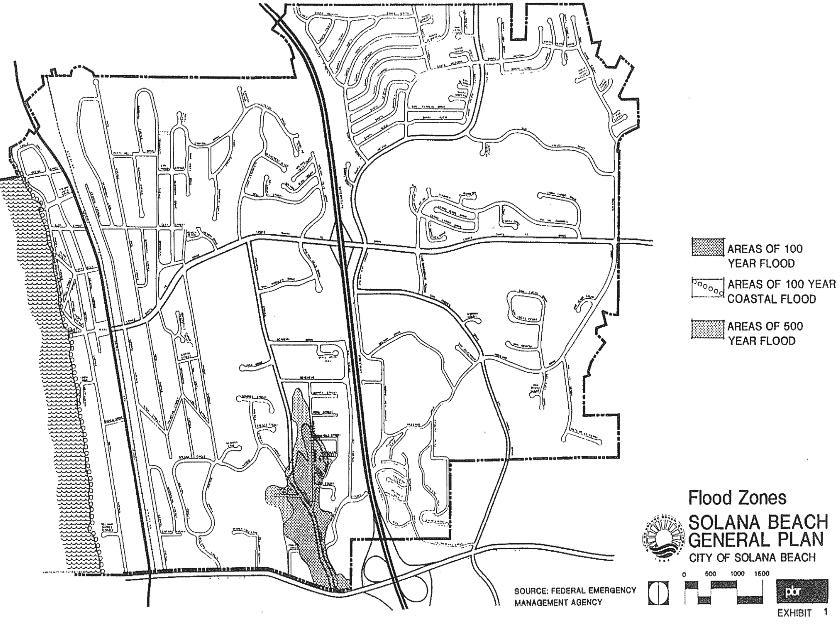
Flood hazard areas in the Solana Beach area have been mapped through the National Flood Insurance Program administered by the U.S. Department of Housing and Urban Development (HUD) and the Federal Emergency Management Agency (FEMA). The Flood Insurance Rate Map (FIRM) prepared for the Solana Beach area delineates areas exposed to potential 100-year and 500-year flooding, including coastal flood hazard areas. Exhibit 1 illustrates the location of Solana Beach’s flood hazard areas.
A 100-year flood, also known as an intermediate regional flood, is defined as flooding that can be expected once every 100 years or which has a one percent probability of occurring in any given year. A 500-year flood, also known as a standard project flood, is defined as flooding that would occur if the maximum storm of record in southern California was centered over the previously saturated watershed of a given drainage course. Most flood control projects are designed for flooding of this magnitude (hence the name, “standard project flood”) since it is regarded as a reasonably foreseeable worst-case scenario. The recurrence interval for standard project flooding is generally estimated to be once every 200 to 300 years.
2.3.3 Land Use and Hydrology Issues
The relationship between land use and flood hazards has two key aspects. First, the potential for flooding is a major constraint to land development in that the hazards posed by flooding severely restrict the types of land uses within the floodplain. Second, urban land use development could result in adverse effects on downstream areas by increasing the potential for flooding. These key considerations are discussed below.
FLOODPLAIN ZONING/LAND USE COMPATIBILITY
Floodplains are relatively flat land areas subject to periodic inundation by nearby drainage courses. These areas have historically attracted human settlement by virtue of their flat terrain, proximity to water, and soil characteristics that are often very fertile. It is important to recognize that periodic flooding is a natural process that creates the conditions on the floodplain which attracts development in the first place. Flooding represents a hazard only after human settlement on the floodplain exposes people and property to risks associated with the inevitable flood flows.
Of course, water control measures such as the construction of dams, levees, retention basins, channel improvements, etc. are available to reduce the extent of flooding. However, even the most modern engineering practices cannot be substituted completely for implementing appropriate land use restrictions within floodplains.
Areas potentially subject to inundation by 100-year floods should generally be limited to land uses that do not interfere with the capacity of the drainage course and that minimize hazards posed to people and property. Thus, agricultural and recreation/open space land uses are considered the most appropriate land uses for the 100-year flood zone. Further, the development of any such use should not involve, or at least minimize, the development of structures that would be exposed to 100-year floodwaters. The only areas in Solana Beach where development has occurred within a 100-year flood zone is in the Stevens Avenue/Valley Avenue area. No new urban development should be permitted within any 100-year flood zone unless it can be demonstrated that building pads will be located above the 100-year flood level and/or floodproofing measures are incorporated into project design.
Areas within the 500-year floodplain are generally subject to a lesser degree of risk as compared to the 100-year floodplain. Therefore, urban land uses may be permitted with the understanding that some degree of risk is assumed for potential damage resulting from infrequent and typically shallow flooding. The only area in Solana Beach where development has occurred within a 500-year flood zone is also in the Stevens Avenue/Valley Avenue area.
EFFECTS OF URBANIZATION
Urban development can result in adverse effects upon downstream areas involving increased flooding and/or erosion and sedimentation problems. Since urbanization involves the construction of streets, sidewalks, parking lots, and buildings, the amount of impermeable land area within the watershed is increased. Thus, the increase in impermeable surfaces associated with buildout of the Solana Beach General Plan is expected to reduce the land area capable of absorbing precipitation. Consequently, stormwater runoff conveyed to the San Dieguito River and the San Elijo Lagoon will increase in both volume of flow and flow velocity.
Further, urban development typically involves the development of storm drain systems designed to convey stormwater from urban development directly to streams and river. While the effect of individual projects themselves may be relatively minor, the cumulative effect of increased impermeable surfaces and storm drain construction throughout upstream portions of Solana Beach could result in greater frequency and magnitude of flooding in downstream areas. However, given the extent of existing urbanization in Solana Beach, additional effects upon downstream areas are expected to be very minor.
Urbanization also can result in increased erosion and sediment transport effects. As vegetation is removed during site preparation and grading activities, soil is exposed and is much more susceptible to wind and water erosion. Further, the increased velocity of runoff resulting from the construction of impermeable surfaces can increase the erosive power of storm flows. Thus, downstream areas such as San Elijo Lagoon may experience increased sediment deposition which can affect water quality and related biological resources adversely.
2.4 Fire Hazards
2.4.1 Types and Causes of Fires
Fire hazards in Solana Beach take two basic forms: structural fires and brush fires. Structural fires in urban areas typically pose an immediate hazard to the affected structure’s occupants and any nearby structures. Such fires are usually caused by arson, carelessness, or by malfunctioning equipment and are usually brought under control relatively quickly by Solana Beach’s Fire Department.
Brush fires (also known as wildland fires) can spread quickly across a wide portion of undeveloped area, particularly hillside areas. Although some wildland fires have a natural origin (ie., lightning), the vast majority are caused by human beings either through arson or through carelessness. Given the far-reaching and potentially devastating consequences of wildland fires, it is important to recognize high fire hazard areas and to integrate related considerations into the land use planning and development process. The following subsections describe areas of high fire hazard in the Solana Beach area and discuss ways to minimize such hazards through appropriate planning and development measures.
2.4.2 Existing Fire Hazard Areas
With respect to structural fires, the Solana Beach Fire Department designates “target hazard” locations based on characteristics involving the type of use, population density, and/or structural condition. For example, schools are considered target hazard locations given the type of use and number of people typically using school structures. The high density residential development along Sierra Avenue south of Plaza Street is a target hazard area primarily because of population density considerations.
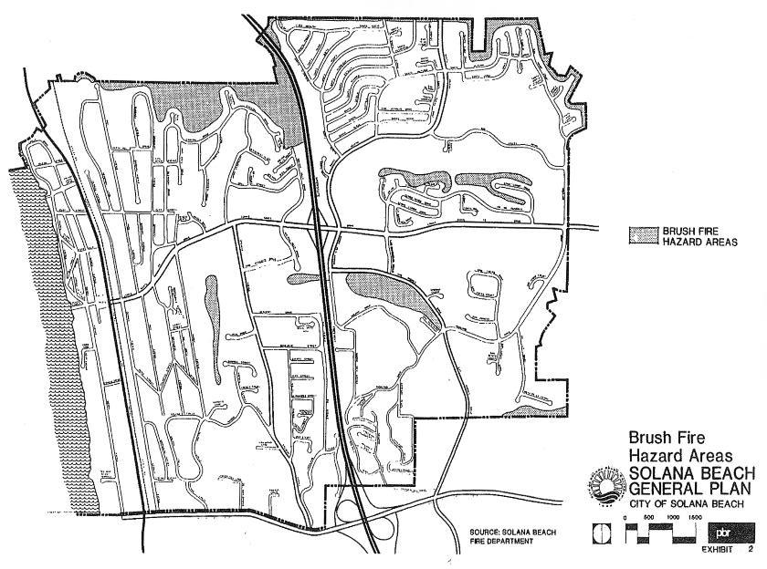
As shown on Exhibit 2, several hillside areas within the city are classified as brush fire hazard areas. These classifications reflect an area’s characteristics related to fuel loading (ie., the density and type of vegetation) and topography. Brush fires tend to spread more rapidly on steeper slopes and firefighting is more difficult on steeper slopes since the mobility of firefighters and equipment is much more limited.
The city’s primary brush fire hazard areas include hillsides along the northern edge of the city above San Elijo Lagoon, the area between San Andres Drive and Solana Drive, and the area generally between Nardo Avenue and Stevens Avenue.
2.4.3 Fire Hazard/Land Use Considerations
Although most brush fires are caused by human beings, it is important to recognize that fires are part of the natural cycle. They are occasionally necessary to eliminate dead vegetation and to help regenerate the ecosystem. They are considered hazardous primarily because of the dangers they pose to human beings and developed properties. The need to minimize the exposure of people and property to fire hazards requires a twofold approach. One aspect involves the use of appropriate land use planning and development regulations. The second aspect involves fire prevention, management, and control measures. Each aspect of this twofold approach is described below.
PLANNING AND DEVELOPMENT REGULATIONS
Land development within or adjacent to areas of high fire hazard will increase the number of people exposed to risk and will increase the value of property that could be destroyed. Further, by altering vegetation and increasing human activity in such areas, land development can increase the degree of potential hazard.
Perhaps the most appropriate land uses within high hazard areas would be open space preserves or light recreational facilities. However, urbanization has already occurred throughout the city, including neighborhoods adjacent to hillside areas susceptible to brush fires. Further, practical considerations involving the development rights of private landowners, the need for a balanced mix of land uses in Solana Beach, and the public cost of maintaining open space/recreational areas limit the extent to which high hazard areas can be restricted from development. Nevertheless, the general plan provides for open space in the Holmwood Canyon area partly as a measure to limit the potential for additional urban development in this area of high brush fire potential.
Since a complete prohibition of development in all high hazard areas is not practical, it is necessary to ensure that future land uses are developed in accordance with strict regulations concerning land use types, densities, and site design.
In general, site plans for any new development proposed in high hazard areas are subject to the review of the Solana Beach Fire Department during the city’s site plan review process. Such plans must satisfy the city that the site provides adequate emergency access, has adequate water supply and pressure to meet fireflow needs, and provides an adequate fuelbreak or buffer zone to prevent the spread of structural fires to hillside areas. Further, strict enforcement of building codes will minimize potential fire hazards resulting from inappropriate building materials or structural design.
PREVENTION AND CONTROL
The imposition of strict zoning and development regulations such as those referenced above represents a key method of fire prevention. Other fire prevention and control measures include the removal or reduction of vegetation that constitutes fuel for fires in or near developed areas, controlled burning (particularly in areas of dense, dead vegetation), and the development of a network of firebreaks that reduce the potential spread of wildfires.
Maintaining adequate emergency response capabilities is also necessary to ensure that fires are controlled if and when they occur. One method to ensure adequate emergency response capabilities is to provide the Solana Beach Fire Department with sufficient financial resources to maintain its facilities, equipment, and personnel at levels appropriate to the needs identified by the city’s Fire Chief. A second method involves maintaining city and county emergency roads to high fire hazard areas to keep them unobstructed and in adequate condition so that emergency vehicles will continue to have access to these areas.
2.5 Hazardous Materials
2.5.1 Introduction
A hazardous material is defined as any injurious substance, including pesticides, herbicides, toxic metals and chemicals, explosives, volatile chemicals, and nuclear fuels and materials. The use of hazardous materials is widespread today in industrial and agricultural activities. As a result of revelations during recent years regarding the adverse health effects of hazardous materials (eg., Love Canal in upstate New York and the Stringfellow Acid Pits in southern California), public concern about this issue has grown significantly. This increased attention has led to a variety of federal, state and local regulations controlling the transport, use, storage, and disposal of hazardous materials.
Hazardous materials can be classified into four general categories: toxins, irritants, flammables, and explosives. Toxins include a wide range of industrial chemicals and agricultural pesticides which are capable of producing serious illness or death due to poisoning. Irritants can cause inflammation or destruction of living tissue with effects ranging from mild to severe, based on the degree of exposure and the type of material involved. Flammables are dangerous because of their low ignition temperatures and rapid burning characteristics. Some flammables burn so violently that they cannot be extinguished, and must be allowed to burn out naturally. Explosives can produce rapid chemical reactions causing damage due to blast and flash fire. Because of their widespread use, it can be assumed that each type of hazardous material is either transported through, used, or stored to some degree within the Solana Beach area.
The following subsections describe the known status of existing hazardous materials conditions in Solana Beach and describe strategies to safeguard the public from risks involving hazardous materials incidents.
2.5.2 Existing Hazards
Potential public health and safety effects associated with hazardous materials generally involve dangers present at a given site and risks associated with transporting hazardous materials. Potential dangers at a given site may involve the production, storage, use, and/or disposal of hazardous materials.
Pursuant to Assembly Bill (AB) 3750, the state Office of Planning and Research (OPR) has compiled a list of hazardous materials sites throughout California. Based upon input from the State Department of Health Services, the State Water Resources Control Board, and the California Waste Management Board, the list is intended to inform local agencies of hazardous waste and substance sites identified by the state as being within the local agencies’ jurisdictions.
AB 3750 requires each applicant for a development project to consult the list, available at the local agency, and to submit a signed statement indicating whether or not the proposed project is located on a listed site. This statement must be submitted prior to the local agency’s determination that the project’s applications are complete.
As of December 1987, there are no sites within or in close proximity to Solana Beach included on OPR’s list. This status is subject to change as new information becomes available in conjunction with OPR’s semi-annual update of the list. Hazardous materials are likely to be found at some light manufacturing uses (eg., solvents and toxic metals) and at some commercial uses (eg., underground storage tanks at automobile service stations).
In terms of hazardous materials transportation, the key area of concern is Interstate 5 since it bisects the city and carries a high volume of traffic. As the principal route between San Diego and Los Angeles, hazardous materials are likely transported through Solana Beach every day. Data specifically regarding the transportation of hazardous materials through the city are not readily available. However, a review of California’s recent experience involving hazardous materials is useful to understanding the nature and degree of potential risks due to hazardous materials transportation in the Solana Beach area.
Based upon the Congressional Office of Technology Assessment’s findings regarding the amount of hazardous materials transported nationally, an estimated four to five million truckloads of hazardous materials are transported annually throughout California.7 The California Highway Patrol (CHP) has estimated that approximately 15 percent of trucks in rural areas and 25 percent of trucks in urban areas carry hazardous materials.8 Although the likelihood of accidents involving truck traffic transporting hazardous materials is not greater than that for general truck traffic, the consequences of incidents and accidents9 involving hazardous materials are much greater.
Of the 342 incidents on California’s state highways involving hazardous materials reported by Caltrans in fiscal year 1984-85, 103 (or 30 percent) were accidents. The CHP reported 166 hazardous materials incidents on state highways and unincorporated county roads in 1985, of which 76 (46 percent) were accidents.10
Caltrans reported a total of 137,388 accidents on state highways in 1985. Thus, the 103 accidents involving hazardous materials transporters represented approximately 0.07 percent of the accidents which occurred on state highways. It is important to note that of these 103 accidents, 86 (83.5 percent) were attributed to driver error (ie., error on the part of the driver of the transporter or on the part of the driver of another vehicle).11 In general, human error has been determined as the cause of approximately 90 percent of total truck accidents statewide.12
Hazardous materials incidents (not involving vehicular accidents) on California’s highways have also been attributed primarily to human error. Such errors typically include driver error in accepting improper shipments, mistakes when loading and unloading shipments, and failing to secure loads and/or closures properly.
2.5.3 Hazardous Materials Management
Regulations and enforcement of safety measures for the storage and use of hazardous materials is the responsibility of numerous agencies, including local fire agencies. National, state, and local fire codes act as a guideline for local enforcement.
The city Fire Department is currently working with the County of San Diego’s Hazardous Materials unit to compile a list of businesses that either produce, use, or store hazardous materials. In addition, the city is considering the inclusion of an additional Fire Department staff member to manage the city’s hazardous materials data base and to work with the community to ensure compliance with appropriate codes and regulations governing hazardous materials.
The U.S. Environmental Protection Agency (EPA) ensures that containers of hazardous materials are properly labeled with instructions for use. The California Department of Industrial Relations, Cal-OSHA Division, regulates the proper use of hazardous materials. The U.S. Department of Agriculture and California Department of Food and Agriculture and the Department of Industrial Regulations regulate pest control operations, pesticide dealers, and pesticide users to ensure that hazardous agricultural chemicals are properly used.
To minimize risks associated with hazardous materials transportation, the U.S. Department of Transportation (DOT) and the CHP have instituted a number of programs to minimize the number of truck-involved accidents and the Transportation Safety Act (also known as the Hazardous Materials Transportation Act) authorized the DOT to regulate the safe shipment of hazardous materials. As established in Title 49 of the Code of Federal Regulations, Sections 100-199, the DOT is authorized to:
1. Establish and revise criteria for handling hazardous materials;
2. Require hazardous materials carriers, shippers, and package-container manufacturers to submit biannual registration statements;
3. Grant exemptions to issued regulations;
4. Inspect records and properties relative to packaging, containing, and transporting of hazardous materials;
5. Provide both civil and criminal penalties for violations of the HMTA or its regulations;
6. Establish facilities and staff to evaluate risks and set up a central reporting and data system to facilitate hazardous materials emergency response; and
7. Conduct a continuing review of all aspects of the transportation of hazardous materials to recommend steps to ensure safety and to prepare an annual report to Congress.13
The CHP’s efforts to minimize hazardous materials incidents and accidents are an integral part of its on-going commercial vehicle enforcement program. This program includes the following measures:14
■ Formal inspections of hazardous materials transporters
■ Rules-of-the-road enforcement
■ On-highway and off-highway commercial vehicle inspections
■ Weight enforcement
■ Major incident response teams
■ Concerted education and enforcement efforts directed toward drivers on specified commercial corridors
■ Production of truck safety maps in conjunction with the California Trucking Association and other trucking industry liaison activities
■ Participation in the Department of Health Services’ Hazardous Waste Strike Force
The CHP believes that the implementation and improvement of on-going commercial vehicle programs effectively reduces the risk of truck-involved accidents.
2.6 Aircraft Hazards
The Naval Air Station (NAS) Miramar is the closest air facility to Solana Beach. It is a military air installation located approximately 8-2/3 miles to the southeast of the city. It does not pose any extraordinary hazard to Solana Beach given its distance from the city. Therefore, no special planning measures are necessary to manage potential aircraft (both fixed and rotary wing) hazards in Solana Beach, although the city should work with the FAA to reduce overflights, including those for advertising purposes.
2.7 Other Public Safety Issues
2.7.1 Law Enforcement
The city of Solana Beach contracts with the San Diego County Sheriff’s Department for law enforcement services. The Sheriff’s Department provides the city with a full range of services which includes uniformed patrol, detective follow-up, traffic enforcement, accident investigation, aviation support, and administrative and supervisory functions.
The Sheriff’s Department serves the city from its Encinitas Substation. The department currently uses a guidelines for minimum service of one 24-hour patrol unit for every 13,275 residents (not including traffic enforcement).
Response time to priority calls to areas within the city is approximately 8.4 minutes (mean average) or 7.0 minutes (median average). Non-priority call response time is approximately 14.3 minutes (mean) or 8.0 minutes (median).
The Sheriff’s Department typically responds to growth by assigning additional deputies to an area in direct proportion to its increase in population. Accordingly, the need for augmented law enforcement services resulting from increased population in Solana Beach can be met by increasing the number of deputies available to the city commensurate with the city’s ability to pay. Further, the need for increased law enforcement services can be minimized to some degree by improving the city’s traffic circulation systems and by requiring new developments to incorporate “defensible space” measures in project design. Such measures typically include adequate lighting of exterior areas and the use of burglary-resistant hardware and fixtures in buildings.
2.7.2 Public Health
Scripps Memorial Hospital in Encinitas currently provides emergency services to Solana Beach and neighboring communities. The hospital offers the following types of emergency services:
■ Total medical services for emergency care, 24 hours daily.
■ Emergency backup by Scripps staff physicians as requested for outpatients.
■ Transfer of emergency cases where appropriate.
■ Treatment of patients who have no attending physician, referral to private physicians from emergency department referral list.
■ Evaluation of employees for job-related injuries/diseases.
■ Participation in promoting a community base plan for external disasters.
Examples of emergency care available include:
■ Suturing and repair of lacerations
■ Treatment of all orthopedic injuries
■ Emergency cardiac care
■ Emergency childbirth
■ Pediatric treatment
■ Emergency treatment of all medical diagnoses
At present, the hospital does not function as a maternity center. Deliveries are done on an emergency basis. Transport to maternity centers is done on all elective deliveries. Maternity services are offered at Scripps Memorial Hospital in La Jolla.
Advanced cardiovascular surgery is conducted when needed at Scripps-La Jolla with transport from the Scripps-Encinitas emergency department to La Jolla by critical care helicopter ambulance transport.
The hospital currently provides 93 beds (as of 1988) and experienced an occupancy rate of about 76.5 percent in 1987. In response to the extraordinary growth experienced in the North San Diego County area, the hospital is constructing a new wing. This wing will have 150 patient beds, 50 of which will be devoted to rehabilitation services. The old wing will be used for auxilliary services and office space. Included in the plans is an expanded 10-bed emergency department. Also, a heliport may be constructed.
A key public health issue in Solana Beach involves leakage problems experienced with residential septic systems. The age and poor condition of septic tanks in these areas have resulted in leaking systems which saturate soils and eventually affect downstream areas adversely with raw sewage.
The City Council of Solana Beach recently issued a policy statement on the use of new septic systems as well as expanding existing septic systems.
2.7.3 Marine Safety
The Solana Beach Department of Marine Safety provides beach and aquatic emergency services along the beach within the city. The lifeguard headquarters at 111 South Sierra Avenue is staffed with three full-time personnel and houses the department’s fleet of four 4-wheel-drive vehicles, and equipment used for cliff rescues, underwater search and rescue activities, and small boat rescues. The facility also serves as a weather station for the National Weather Service.
A staff of 45 lifeguards is used on a seasonal basis for operations conducted at three lifeguard stations (with a fourth station added during the summer). These stations are sited at principal beach access points.
2.7.4 Disaster Preparedness
Disaster preparedness typically involves the development of response procedures, identification of evacuation routes, design and installation of warning systems, purchase of emergency equipment, and training of emergency personnel. It is through such proactive measures that the effectiveness of other emergency management procedures is ensured.
These other emergency management procedures include response, recovery, and mitigation programs. Response mechanisms come into play when a hazard event occurs and may include warnings, evacuations, rescue operations, fire fighting, emergency medical care, emergency food and shelter provisions, and measures to preserve public health and safety such as riot control.
Following the hazard event, recovery activities may involve repairing damaged roads, buildings, pipelines, and re-establishing the community’s physical, social, and economic systems.
Mitigation programs are akin to preparedness actions in that they are measures to reduce or eliminate the adverse effects of future hazard events. Mitigation programs are those that go beyond the typical objectives of preparedness, response, and recovery. The principal forms of mitigation are as follows:
■ Implementation of land use controls to prevent or limit the location of development and populations in areas that are susceptible to hazard events;
■ Enforcement of building codes established to minimize the likelihood or extent of damage, which may necessitate the design or construction of a building; and
■ Installation of structural barriers (eg., dams and levees) to shield people and development from harm.
The city of Solana Beach’s Fire Chief is responsible for overseeing the city’s disaster preparedness program. Solana Beach’s program for local emergency management is currently being prepared by the Fire Department and is expected to designate appropriate evacuation routes and emergency shelters. The program is also expected to establish appropriate management procedures to be followed by emergency personnel.
Larger emergency response actions are managed on a regional basis by the county of San Diego, on a statewide basis by the State Office of Emergency Services, and on a federal basis by the Federal Emergency Management Agency (FEMA). Solana Beach’s Fire Chief is responsible for coordinating the city’s emergency response actions with these agencies.
3.0 Goals, Objectives, and Policies
GOAL 3.1
TO MINIMIZE HAZARDS TO PUBLIC HEALTH, SAFETY, AND WELFARE RESULTING FROM NATURAL AND MAN-MADE PHENOMENA
Objective 1.0
Ensure that geologic hazards in all areas for human use or habitation are mitigated properly or avoided prior to or during development.
Policy 1.a The city shall require geotechnical investigations by a certified engineering geologist for all grading and construction proposed within any area of significant erosion, slope instability, and/or areas subject to severe seismic hazards, including inland and coastal bluffs.
Policy 1.b The city shall provide qualified expertise for the review of geotechnical reports and sufficient personnel for the field inspection of grading operations and construction.
Policy 1.c The city shall require construction to be in conformance with the Uniform Building Code, specifically Chapter 23 as it provides for earthquake-resistant design, Chapter 70 as it provides for excavation and grading, and with the city’s adopted hillside development ordinance.
Policy 1.d The city shall encourage public information programs to encourage increased awareness of seismic and geologic hazards.
Policy 1.e The city shall encourage programs to abate or modify structures deemed hazardous to human habitation.
Objective 2.0
Establish siting and development standards to reduce risk and damage from flood hazards.
Policy 2.a The city shall cooperate with the Federal Emergency Management Agency in defining flood hazard areas within the city.
Policy 2.b The city shall enter into the U.S. Department of Housing and Urban Development’s Flood Insurance Program.
Policy 2.c The city shall enact an ordinance which specifies the types of land uses to be permitted within 100-year flood hazard areas and which requires all structures proposed within 100-year flood zones to be elevated at least one foot above the 100-year flood level.
Policy 2.d The city shall require the submittal of information prepared by a qualified civil or hydrological engineer which certifies compliance with development standards established for 100-year flood zones.
Objective 3.0
Minimize the adverse effects of urbanization upon drainage and flood control facilities.
Policy 3.a The city shall require the implementation of adequate erosion control measures for development projects to minimize sedimentation damage to drainage facilities.
Policy 3.b The city shall maintain its open space preserves and shall require developers to provide adequate open space pursuant to the standards established in the Conservation and Open Space Element of the General Plan and the city’s zoning ordinance as a measure to minimize impermeable surfaces throughout the city.
Policy 3.c The city shall cooperate with the San Diego County Flood Control District to ensure that citywide development does not lead to significant adverse effects upon the county’s flood control facilities.
Objective 4.0
Establish fire prevention regulations and standards to minimize potential fire hazards and fire losses.
Policy 4.a The city shall enact an ordinance which establishes criteria for land development in hillside areas with emphasis on fire-retardant construction materials, access for fire-fighting personnel and equipment, removal of combustible vegetation, and minimizing the overall exposure to risks associated with wildfires and adjacent structure fires.
Policy 4.b The city shall enact an ordinance which establishes structural design standards to ensure adequate fire safety.
Policy 4.c The city shall ensure that development is phased properly in relation to the city’s ability to provide an adequate level of fire protection.
Policy 4.d The city shall establish appropriate measures to mitigate potential fire hazards in areas of special concern.
Policy 4.e The city Fire Department shall review proposed site plans to ensure that adequate fire safety measures are provided.
Policy 4.f The city will participate with other communities in mutual aid agreements to ensure effective cooperation among fire agencies.
Objective 5.0
Establish a program to ensure the safe handling, disposal, and cleanup of hazardous materials in conjunction with federal, state, and regional programs and regulations.
Policy 5.a The city shall enact an ordinance which sets forth restrictions and safeguards concerning the use, storage, and disposal of specific hazardous materials.
Policy 5.b The city Fire Department shall establish and periodically update an inventory of hazardous materials produced, stored, or otherwise located within the city for purposes of coordinating emergency response.
GOAL 3.2
TO PROVIDE A SAFE AND SECURE ENVIRONMENT FOR THE CITY’S RESIDENTS, WORKERS, AND VISITORS
Objective 1.0
Provide an adequate level of police protection throughout the city.
Policy 1.a The city shall provide a minimum of one 24-hour police patrol per 13,275 residents.
Policy 1.b The city shall enact an ordinance which specifies site design standards for ensuring adequate emergency access.
Policy 1.c The city shall require new developments and improvements to employ defensible space concepts into site design and building specifications (eg., appropriate setbacks, adequate lighting of walkways and parking lots, and the use of burglary-resistant hardware and fixtures in buildings).
Policy 1.d The city shall encourage the use of state-of-the-art design concepts and technological improvements for the prevention of crime.
Objective 2.0
Enhance public awareness and participation in crime prevention.
Policy 2.a The city shall encourage the San Diego County Sheriff’s Department to establish a Neighborhood Watch program and shall provide ongoing support to participating neighborhoods.
Objective 3.0
Establish an emergency preparedness program and maintain the program through regular practice drills and periodic updating of the program.
Policy 3.a The city shall establish an Emergency Response Team composed of key city staff.
Policy 3.b The city’s Emergency Response Team shall develop a detailed emergency response manual which describes the appropriate actions and responsibilities of personnel designated for participation in emergency response activities. This manual shall become a working document and shall be made available to the public and city staff. Further, this document shall be updated at a minimum of every five years.
Policy 3.c The emergency response manual shall include a map indicating clearly the city’s designated evacuation routes and an operating plan for evacuation management to ensure safe and orderly evacuation.
Policy 3.d The city’s Emergency Response Team shall be responsible for directing the city’s personnel and volunteers involved in disaster relief and emergency evacuation efforts. The team also shall be responsible for coordinating the city’s emergency response with federal, state, and other local agencies.
Policy 3.e The Emergency Response Team shall direct annual practice drills involving key city personnel, volunteers, and other entities responsible for conducting emergency response activities.
Objective 4.0
Protect public safety in potentially hazardous areas such as blufftops.
Policy 4.a The city shall limit public access to hazardous blufftop locations through appropriate barrier installation, signage, etc.
Policy 4.b The city shall discourage the use of seawalls.
4.0 The Safety Plan
As discussed in Section 2.0 of this safety element, a variety of safety issues such as blufftop hazards have a substantial effect upon urban development. To ensure that these issues receive appropriate consideration, the primary responsibility for implementation of the policies established in this safety element is with the city Planning Department and the city’s Fire Chief. The city Planning Department is responsible for evaluating proposed development projects to identify potential hazards associated with the development. The Planning Department’s site plan review process therefore takes into consideration possible seismic, geologic, flood, and fire hazards. Proposed projects which have potential adverse effects related to safety considerations should have measures to mitigate such effects pursuant to the California Environmental Quality Act (CEQA). The Planning Department is charged with ensuring compliance with CEQA in processing development proposals. Nevertheless, the Solana Beach City Council bears ultimate responsibility for certifying compliance with CEQA and for imposing specific mitigation measures as conditions of project approval.
The Fire Department is responsible for reviewing development proposals to identify potential hazards related to fire. The department also is responsible for the appropriate management of emergency response facilities, personnel and equipment as allocated by the Solana Beach City Council.
Disaster preparedness and response activities, including planning, training of personnel, and implementation of response mechanisms (eg., evacuation) shall be managed by the Fire Chief. The Fire Chief is also responsible for interagency coordination. The Solana Beach City Council is responsible for appropriating adequate resources to meet emergency response requirements.
With respect to hazardous materials, the Fire Department, with support from the city Planning Department, is responsible for establishing an inventory of hazardous materials produced, stored, or used in Solana Beach. The Planning Department is responsible for consolidating the city’s inventory with semi-annual listings distributed by the State Office of Planning and Research and for requiring project applicants to consult said list pursuant to the requirements of AB 3750.
5.0 Glossary
Coastal Bluff: Any bluff where the toe of slope is now or within the past 200 years has been subject to marine erosion.
Critical Facility: Includes facilities housing or serving many people or otherwise posing unusual hazards in case of damage from or malfunction during an earthquake, such as hospitals, fire, police, and emergency service facilities, utility “lifeline” facilities, such as water, electricity, and gas supply, sewage disposal, and communications and transportation facilities.
Fault: A fracture in the earth’s crus forming a boundary between rock masses that have shifted.
Active Fault: A fault that has moved recently and which is likely to move again. For planning purposes, “active fault” is usually defined as one that shows movement within the last 11,000 years and can be expected to move within the next 100 years.
Potentially Active Fault: 1) A fault that last moved within the Quaternary Period before the Holocene Epoch (the last 2,000,000 to 11,000 years); 2) a fault which, because it is judged to be capable of ground rupture or shaking, poses an unacceptable risk for a proposed structure.
Inactive Fault: A fault which shows no evidence of movement in recent geologic time and no potential for movement in the relatively near future.
Ground Failure: Mudslide, landslide, liquefaction, or the seismic compaction of soils.
Hazardous Material: An injurious substance, including pesticides, herbicides, toxic metals and chemicals, liquified natural gas, explosives, volatile chemicals, and nuclear fuels.
Liquefaction: A process by which water-saturated granular soils transform from a solid to a liquid state because of a sudden shock or strain.
Seiche: An earthquake-induced wave in a lake, reservoir, or harbor.
Subsidence: The gradual, local settling or sinking of the earth’s surface with little or no horizontal motion. (Subsidence is usually the result of gas, oil, or water extraction, hydrocompaction, or peat oxidation, and not the result of a landslide or slope failure.)
Surface Rupture: A break in the ground’s surface and associated deformation resulting from the movement of a fault.
Wildland Fires: Fires occurring in a nonurban, natural area which contains uncultivated lands, timber, range, watershed, brush, or grasslands.
Geocon Incorporated, Geotechnical Investigation for Solana Beach Lifeguard Facility, Solana Beach, California, January 1988.
Geocon Incorporated, Soil and Geologic Reconnaissance for Solana Beach Community Center Expansion, Solana Beach, California, December 1987.
California Division of Mines and Geology, Urban Geology Master Plan for California – Bulletin 198, 1973.
California Division of Mines and Geology, Fault-Rupture Hazard Zones in California – Special Publication 42, Revised March 1980.
Kim Fulton-Bennet and Gary B. Griggs, Coastal Protection Structures and Their Effectiveness (a joint publication of the California Department of Boating and Waterways and the U.C. Santa Cruz Marine Sciences Institute), undated.
Federal Emergency Management Agency, Draft Flood Insurance Study-City of Solana Beach, California, July 22, 1978.
California Department of Transportation (in cooperation with the California Highway Patrol and the California Public Utilities Commission), Transportation of Hazardous Materials in California by Highway and Rail, a report to the Legislature as required by Chapter 1465, Statutes of 1985 (AB 1311-Leonard), August 1986, p. 2.
Ibid., p. 4.
“Incidents” include deliberate dumping, accidental spills or leaks, and traffic accidents resulting in the release of hazardous materials. “Accidents” are unintentional events that may or may not result in the release of hazardous materials.
Ibid., p. 9. The difference in Caltrans and CHP statistics result from differing definitions, agency responsibilities, reporting requirements, and data collection systems.
Ibid., p. 10.
Ibid., p. 5.
Transportation Research Board, National Academy of Sciences, op. cit., p. 10.
Detailed descriptions of these measures are provided in the book entitled Commercial Vehicle Activities, prepared by the Department of the California Highway Patrol, June 1986.