


Chapter 36.16
IMPLEMENTATION STRATEGIES
Sections:
36.16.010 Implementation strategies.
36.16.020 Downtown District future land use and zoning.
36.16.030 Rail District future land use and zoning.
36.16.040 River District future land use and zoning.
36.16.050 Development standards.
36.16.060 Conceptual plan for traffic circulation in Greater Downtown.
36.16.070 Entryways and signage.
36.16.080 Economic redevelopment.
36.16.090 Greater Downtown area parks.
36.16.100 City-owned Jarvis property.
36.16.010 Implementation strategies.
The City has a variety of tools available through which these goals can be implemented so that the vision for Greater Downtown can materialize and eventually be realized. This plan represents the first phase of implementation and includes the basic implementation strategies of designating future land use designations, zoning properties accordingly as needed, amending development standards of the zoning districts through a zoning overlay and establishing goals and policies for future phases of plan implementation such as economic (re)development strategies.
(Ord. 4571, 3-20-13)
36.16.020 Downtown District future land use and zoning.
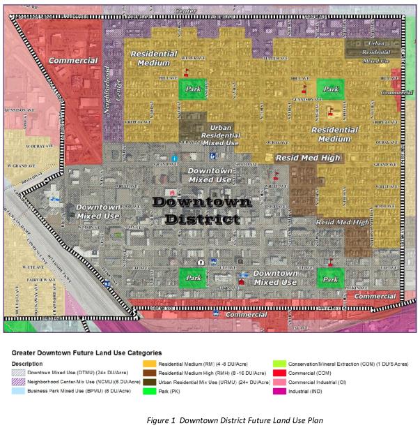
(a) Future Land Use. The Downtown District is formulated around seven general land use designations: Commercial, Downtown Mixed Use, Neighborhood Center Mixed Use, Urban Residential Mixed Use, Residential Medium High Density, Residential Medium Density and Parks and Open Space. These designations correspond with those established in the City-County Comprehensive Plan and are illustrated in Figure 1. A more detailed description of the land use designations may be found in the Comprehensive Plan. The Blended Land Use Map that is included in the Comprehensive Plan and allows for increases in residential density in compatible areas does not apply to properties within the Downtown District. This is due to the strong public sentiment in the Downtown District residential neighborhoods that the existing historic character of the single-family development be protected.
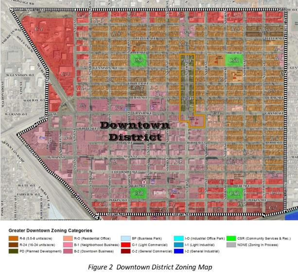
(b) Zoning. Proposed zoning within the Downtown District is shown in Figure 2 and includes the following zone districts: Residential 8 units per acre (R-8), Residential 24 units per acre (R-24), Residential Office (RO), Neighborhood Business (B-1), Downtown Business (B-2), Light Commercial (C-1), General Commercial (C-2), and Community Services and Recreation (CSR). Generally, the zoning is proposed to remain the same as currently exists. A more detailed description of the zone districts within the Downtown District may be found in the Zoning and Development Code.
(Ord. 4571, 3-20-13)
36.16.030 Rail District future land use and zoning.
(a) Future Land Use. The Rail District is shown in Figure 3 and is formulated around five general land use designations: Business Park Mixed Use, Commercial, Commercial Industrial, Industrial and Parks and Open Space. These designations correspond with those established in the City-County Comprehensive Plan. A more detailed description of the land use designations may be found in the Comprehensive Plan.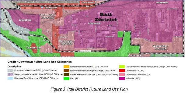
(b) Zoning. Proposed zoning within the Rail District is shown in Figure 4 and includes the Light Commercial (C-1), General Commercial (C-2), Community Services and Recreation (CSR), Business Park Mixed Use (BP), Industrial/Office Park (I-O), Light Industrial, and General Industrial (I-2) zone districts. The majority of the zoning is proposed to remain the same as currently exists. A more detailed description of the zone districts within the Rail District may be found in the Zoning and Development Code.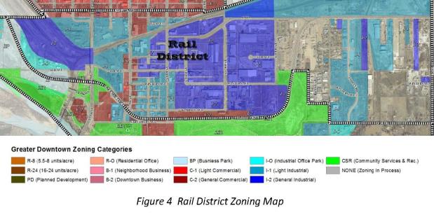
(Ord. 4571, 3-20-13)
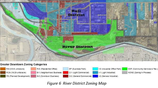
36.16.040 River District future land use and zoning.
(a) Future Land Use. The River District as shown in Figure 5 is formulated around six general land use designations: Commercial, Commercial Industrial, Parks and Open Space, Conservation, Estate and Business Park Mixed Use. These designations correspond with those established in the City-County Comprehensive Plan. A more detailed description of the land use designations may be found in the Comprehensive Plan.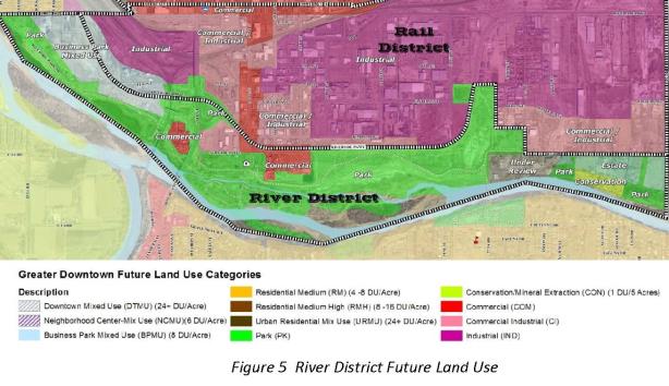
(b) Zoning. Proposed zoning within the River District is shown in Figure 6 and includes the following zone districts: Light Commercial (C-1), General Commercial (C-2), Community Services and Recreation (CSR), Business Park Mixed Use (BP), Industrial/Office Park (I-O), and Light Industrial (I‑1). The majority of the zoning is proposed to remain the same as currently exists. A more detailed description of the zone districts within the River District may be found in the Zoning and Development Code.
(Ord. 4571, 3-20-13)
36.16.050 Development standards.
The community desires to improve the visual character of the Greater Downtown areas that are most visible along major public corridors or from the major public spaces. Consequently, the plan promotes a higher quality built environment through improved architectural character, reduced visual clutter and enhanced streetscape. These elements are addressed through the Greater Downtown zoning overlay detailed in a companion document to this plan. The elements of the overlay are intended to augment the zoning district standards in the Zoning and Development Code.
(Ord. 4571, 3-20-13)
36.16.060 Conceptual plan for traffic circulation in Greater Downtown.
(a) The Grand Junction Circulation Plan adopted by the City of Grand Junction and Mesa County serves as the traffic circulation plan for the Greater Downtown area. The following conceptual plan for traffic circulation in Greater Downtown describes the policies for streets and corridors in the Greater Downtown, depicts preferred conceptual designs and proposes additional unclassified streets which support those policies. This conceptual plan for circulation does not modify the Grand Junction Circulation Plan, but provides preferred concepts and designs for future consideration and development of public rights-of-way.
(b) Policies.
(1) Conduct a more detailed traffic analysis of the area to determine needed intersection control, street cross-sections, pedestrian and vehicle facilities, additional streets and access control, and amend the Grand Junction Circulation Plan accordingly.
(2) Continue the review process for the Grand Junction Circulation Plan to determine needed pedestrian and bicycle transportation facilities such as trails, pedestrian paths and bike lanes, and amend the Grand Junction Circulation Plan accordingly.
(c) In the Grand Junction Circulation Plan, urban streets are classified according to their function in the transportation network. The two components of function of the Grand Junction Circulation Plan are (1) to provide access to properties and (2) to carry traffic safely and efficiently from point to point. In order to preserve safety and capacity and to enhance the quality of living, these two components should be inversely related, such that busier streets have limited access (resulting in more efficient flow) and quieter streets provide access to properties.
(d) Major Street Corridors. The components of the major street system are identified on the Grand Junction Circulation Plan. These corridors primarily function as carriers of traffic from point to point. The conceptual circulation plan in the Greater Downtown Plan includes proposed unclassified roadways shown in yellow on Appendix C, GJMC 36.20.030.
As properties develop and redevelop within the greater downtown area, the Grand Junction Circulation Plan will be implemented through construction or improvement of streets warranted by the proposed development, based on adopted street cross sections in the Transportation Engineering Design Standards (TEDS). The conceptual circulation plan in the Greater Downtown Plan provides preferred alternatives for specific design and layout of certain streets, corridors and intersections in the planning area. For example, in commercially-zoned areas, the Commercial Street cross-sections of TEDS will apply, but modifications may be made according to the conceptual circulation plan illustrated and described here (street cross-sections, illustrations and text).
(1) North Avenue – Arterial Street. A potential layout for North Avenue between 1st and 12th Streets was adopted with the North Avenue West Corridor Plan. The layout is incorporated into the Greater Downtown Plan as depicted in Figure 7.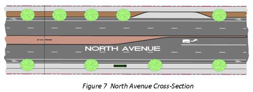
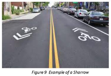
(2) Grand Avenue – Arterial Street. While Grand Avenue is an established street with improved streetscape elements the length of the segment within Greater Downtown (1st to 12th Streets), there could be improvements made in some blocks that would enhance traffic flow, pedestrian safety and visual aesthetics. A typical, potential median improvement to Grand Avenue is shown in Figure 8. The segment of Grand Avenue between 1st Street and 7th Street also has the potential to be used as a “sharrow.” A sharrow is marked as in Figure 9 so that the travel lane may be used by both bicycle and vehicular traffic.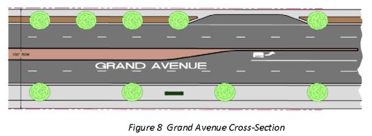
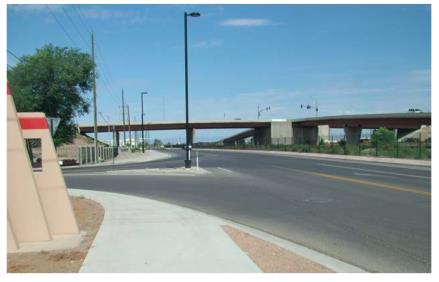
(3) North 1st Street – Arterial Street. The segment of North 1st Street from Grand Avenue to North Avenue is deficient in street design and pedestrian amenities. The Greater Downtown Plan envisions eventual redevelopment of this street to improve safety, drainage, pedestrian circulation, access and improve on-street parking. A potential layout is shown in Figure 10.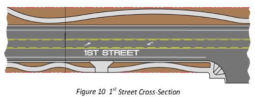
(4) 1st Street and Grand Avenue Intersection. The Colorado Department of Transportation (CDOT) completed an environmental assessment for the I-70B/6 and 50 corridor which recognized circulation needs at the 1st and Grand intersection. A potential design is shown in Figure 11. This design is incorporated into the Greater Downtown Plan as are any potential improvements CDOT may include in this project on 1st Street from Grand Avenue to Pitkin Avenue.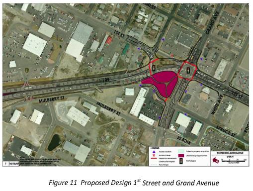
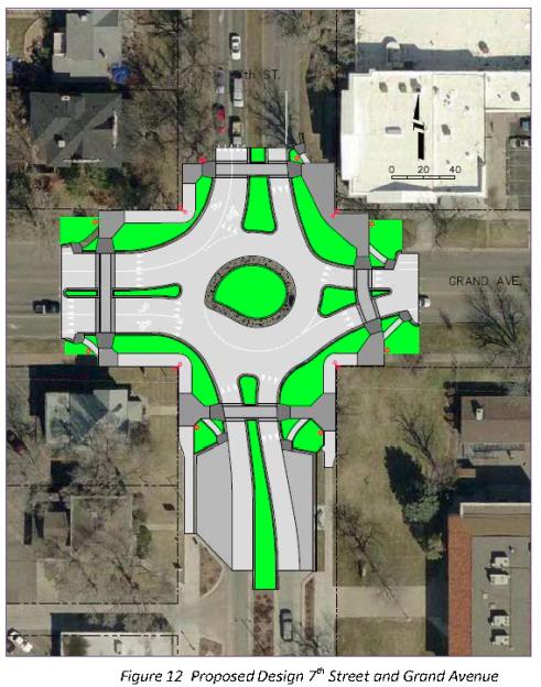
(5) 7th Street and Grand Avenue Intersection – A design for a roundabout was included with the plans for 7th Street improvements that were completed in 2007-2008. The roundabout was not constructed at that time, but the intersection still warrants vehicular and pedestrian improvements. The plan as originally proposed is shown in Figure 12.
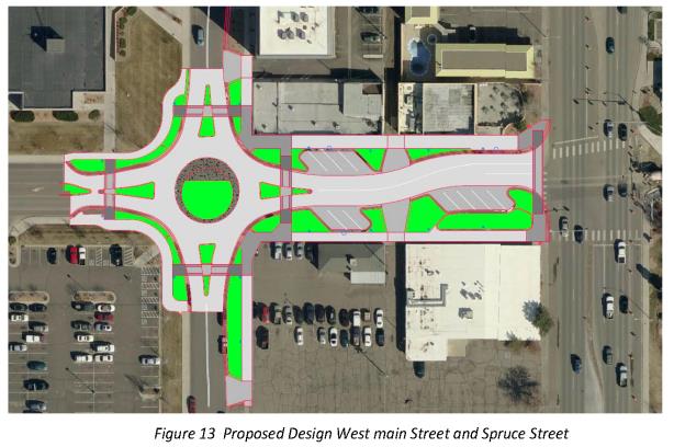
(6) West Main Street and Spruce Street Intersection. Vehicular and pedestrian traffic has increased on the West Main Street corridor due to activity at the County Justice Center and the Mesa County Central Services building. To ease traffic flow through the area and improve pedestrian safety, this potential project for a roundabout at Spruce and West Main Streets was originally conceived during the visioning of Main Street in 2008 (Figure 13). The roundabout would serve as a visual anchor to the west end of Main Street just as the one at 7th Street serves the east end. The roundabout would also allow for a circulator bus to serve the Main Street corridor from Spruce Street to 7th Street.
(7) Riverside Parkway – Arterial Street. The right-of-way width varies; multi-lane; bike lanes; detached walk on the south side; no on-street parking. Completed in 2007.
(8) South 7th Street. Suggest two lanes; bike lanes; on-street parking both sides; detached walks with landscaping. The streetscape plan for South 7th Street should be enhanced with a similar design as was constructed on 7th Street south of Grand Avenue. Generally, the design would continue the 7th Street boulevard treatments from downtown, Ute and Pitkin to the Botanical Gardens and riverfront area with additional street trees, historic street lights, street furniture and public art. This concept would create a more consistent visual character to connect the River and Rail Districts to the traditional downtown area and improve the visual design of the corridor and emphasize its use as the primary public north-south corridor through the neighborhood. The concept features enhanced pedestrian facilities with colored concrete, pedestrian safe zones at the “bulb-outs” for easier crossing and additional landscaping.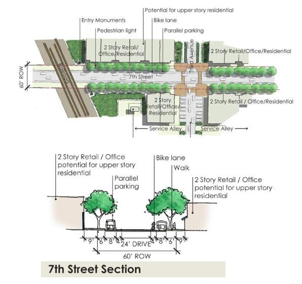
(9) South 9th Street and 27-1/2 and C-1/2 Roads. Suggest two lanes; on-street parking both sides; detached sidewalk preferred where possible. The streetscape plan for South 9th Street is to develop similar to what presently exists along South 7th Street with a more defined hardscape of curb and gutter, enhanced pedestrian facilities and street trees. This concept improves the visual quality of the corridor without requiring improvements on private property or compromising adjacent uses. The concept also allows the street to function for the commercial/light industrial traffic that it carries as well as provides for a more comfortable pedestrian or bicycle environment since South 9th Street may be used by the public to access business/commercial areas and Las Colonias Park.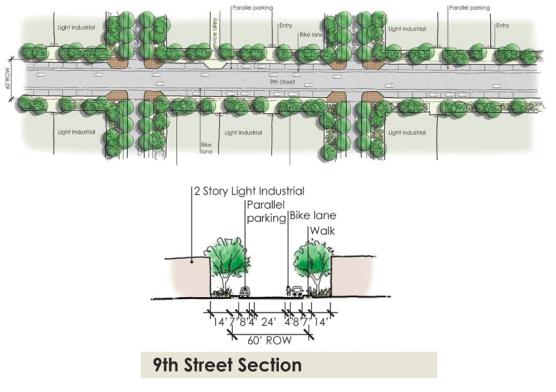
(10) Kimball Avenue. Suggest two lanes; on-street parking; detached walks with landscaping.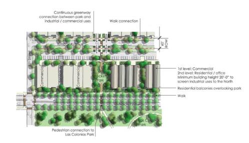
(11) D Road (from 9th Street east to the Riverside Parkway). Section yet to be determined.
(e) Local Streets. The components of the local street system are identified on the Grand Junction Circulation Plan. The primary function of the local street network is to provide access to and connections among individual parcels and subdivisions, provide a safe network for movement of pedestrians and bicycles, and serve short length trips to and from collector and higher order streets. Trip lengths on local streets should be short with a lower volume of traffic moving at slower speeds. As properties develop and redevelop within the greater downtown area, the Grand Junction Circulation Plan will be implemented through construction or improvement of streets warranted by the proposed development, based on adopted street cross sections in the Transportation Engineering Design Standards (TEDS), GJMC Title 29.
(f) Trails. The Grand Junction Circulation Plan shows the location of future bicycle facilities, trails and pedestrian paths. As development or redevelopment occurs, trails, paths, bike lanes and pedestrian facilities will be constructed in accordance with the adopted Grand Junction Circulation Plan. Also the City may construct these facilities using transportation capacity payments (TCP) funds as part of one or more capital improvement project(s). The Grand Junction Circulation Plan is currently undergoing review by the City of Grand Junction and Mesa County. The conceptual circulation plan of the Greater Downtown Plan includes, in Appendix C, GJMC 36.20.030, the a preferred alternative for trails, paths, bike lanes and pedestrian facilities in the Greater Downtown planning area. The preferred alternative shown comes from a 2012 draft of proposed amendments to the Grand Valley Trails Plan (now Grand Junction Circulation Plan), and it includes the following:
(1) Extension of Riverfront Trail from Las Colonias Park east to 28 Road (and beyond).
(2) Bike routes (signs but no separate lane) on Grand Avenue from 7th Street east and 28 Road between the Riverside Parkway and C-1/2 Road.
(3) Sharrow bike routes (bikes share slightly wider lane with cars as depicted in Figure 9) on Grand Avenue between 1st and 7th Streets.
(g) Riverside Parkway Pedestrian Overpass. This conceptual circulation plan envisions one or more pedestrian overpasses from the commercial areas of the Rail District to the riverfront areas and Las Colonias Park. Activities and uses in the future park, types of development along the north side of the Parkway will determine where such facilities may be needed. An overpass on the western end in the vicinity of 7th or 9th Streets could also serve as an entrance feature to the neighborhood as further discussed in GJMC 36.16.070.
(h) Public Transportation. Grand Valley Transit (GVT) presently serves the Downtown District but does not provide service in the Rail and River Districts. Future transit needs within the Rail and River Districts should be monitored as development or redevelopment occurs in these areas and as Las Colonias Park sees more activity.
(Ord. 4571, 3-20-13)
36.16.070 Entryways and signage.
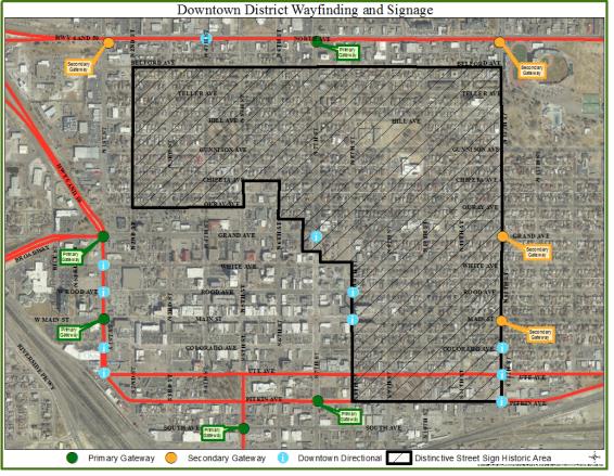
Important intersections in the street network offer opportunities to develop a unique theme and identity for the Greater Downtown area. The primary intersections vary in scale and include entries to the Downtown, Rail and River Districts. Each of these should be developed according to general concepts and criteria that are appropriate for their scale, function and importance.
(a) Downtown District Entryways and Signage. While the Downtown District has a strong base of local and regional users, approaches to the District offer no distinguishing features or directional signage that orient first time visitors. When approaching or traversing perimeter streets, visitors have no sense that they are within eyesight of the historic town site or even that they are headed in the right direction toward downtown. Creating gateways at key entry points, as well as simple perimeter identifiers, will orient visitors, as well as strengthen and celebrate the heritage of the Downtown Districts. Because of the diversity of uses and neighborhoods within the Downtown District, the design of entryways should include a range of sizes, poles and ornamentation of signage and varied landscape elements, lighting and other features that are integrated with the signage. The primary gateways to the Downtown District and between downtown and the Rail District include the following intersections:
(1) 7th Street and North Avenue.
(2) 1st Street and Grand Avenue.
(3) 1st Street and Main Street.
(4) 5th Street and South Avenue.
(5) 7th Street and Pitkin Avenue.
In addition, the distinctive public sign palette already started in the Downtown District should be continued and expanded to include street signs and directional signs that have recognizable poles, ornamentation, colors, fonts and logos. The City, together with the DDA, will further develop sign standards and guidelines for private signage placed on buildings or as freestanding signs.
(b) Rail and River District Entryways.
(1) 5th Street/Riverside Parkway. There are opportunities to celebrate the entry into Grand Junction and the Rail and River Districts at the 5th Street bridge and Struthers Avenue area in conjunction with the Western Colorado Botanical Gardens with attractive low scale signage and sculpture. In addition, there are smaller monuments at various points along the Riverside Parkway that indicate to motorists that they are approaching or traveling on the Riverside Parkway. Due to the scale of the 5th Street/Riverside Parkway intersection and the publicly-owned area around it, this intersection affords the opportunity to create a monument/sculpture of a much larger scale to mark the entrance and give identity to the Rail and River Districts and/or to this “Grand Junction.”
Another possibility in this vicinity is if a pedestrian overpass is desired/needed near the 7th Street/Riverside Parkway intersection it could serve several purposes: pedestrian access across the Parkway, include design elements that give a distinct character to the Rail and River Districts and integrate with surrounding open space, pocket parks and/or water features at the landings on each side of the Parkway.
(2) South 7th Street/Railroad Tracks. There is an existing silo on the Mesa Feed property that identifies the Rail District as you travel south on 7th Street. It is of a scale that is visible from the southern perimeter of downtown and represents the historical agriculture and industrial base upon which the Rail and River Districts have developed. Such a structure could be enhanced and/or replicated to become an even stronger element at this major entrance to the area.
(3) 28 Road/Riverside Parkway. This intersection is a smaller scale than the others, but a neighborhood entry could be created, particularly along the north side. The sense of arrival at this location could be created through a water feature, public art, an architectural feature with signage paving patterns and/or landscaping. The design of the entry feature should be of the same character of those that might be created at the other major entry points.
(Ord. 4571, 3-20-13)
36.16.080 Economic redevelopment.
(a) Downtown District Economic Redevelopment. While the Downtown District is the heart of the community, it is but one subset of a larger market and has strengths which can be capitalized on and limitations which should be overcome. The Downtown District has a tremendous influence on the economic well-being of the entire region. Therefore, it is widely accepted that early projects in any revitalization effort could be publicly assisted until market conditions reach levels where new construction can support itself.
The Grand Junction Strategic Downtown Master Plan presented guiding principles which, while general in nature, were considered responsive to prevailing conditions, market opportunities, framework elements and stakeholder input. These guiding principles are still relevant to the Greater Downtown Plan and are listed and described below.
(1) The Downtown District is one submarket that competes with other submarkets in Grand Junction. The downtown environment, while presenting tremendous opportunity for investment in a setting uniquely positioned to offer both heart and history, carries with it certain limitations, particularly for land-intensive non-destination-oriented land uses. Several market sectors, however, not only survive, but also thrive in a downtown setting. Recognize the obstacles associated with downtown development and encourage regulatory and financial solutions including public subsidies and creative financing mechanisms.
(2) The Downtown District must be market-responsive to changing conditions, with implementation tools and mechanisms in place to both offset competitive disadvantages and capitalize on competitive assets. Market conditions should be continually monitored and information distributed to a broad audience including developers, business and property owners, lenders, city staff and elected and appointed officials.
(3) The Downtown District infrastructure must be protected and retained including physical features, service organizations, mix of employers, historic residential neighborhoods and community attitudes toward the Downtown District. Unlike many communities across the country, Grand Junction’s Downtown District existing infrastructure is more than sufficient to promote itself as a downtown neighborhood. These assets, which provide the impetus for investment, need to be protected and promoted.
(4) The Downtown District’s “tool bag” must contain a variety of strategies and mechanisms to attract investment. These tools can be financial, physical, market, or organizational in nature and can be used independently or in various combinations. Given the obstacles associated with downtown development, it is imperative that whatever mix of tools is put in place it be comprehensive, flexible and creative.
(5) Public investment must leverage private investment. Historically, the planning, financing and implementation of projects in the downtown market were the primary responsibility of public sector entities such as the City and the DDA. However, while the public sector continues to play a significant role in most downtown efforts, a critical component to the success of any revitalization strategy today is participation by both the public and private sectors. Leveraging of resources is key, as no one entity, public or private, has sufficient resources alone to sustain a long-term downtown improvement effort.
(6) Public policy must support development in the Downtown District. Experience has proven that downtown development will best succeed if regional growth management programs reward efficient development patterns. If growth is allowed to occur in a land extensive, inefficient way that effectively subsidizes lower densities, downtown development will operate at a competitive disadvantage. Given Grand Junction’s existing land use patterns, the Downtown District is susceptible to continued dilution of its role as the community’s central business and shopping district.
(7) Public-private partnerships are essential. Under any investment strategy, local government needs to have strong involvement, a visible presence, perhaps be the entity that provides continuing leadership, regulatory incentives, and seed capital for early projects. Not only does government have the legal responsibility to address many of the implementation components, but it is also the logical conduit to local, regional, state and federal funding sources.
(b) Rail and River District Economic Redevelopment.
(1) The changes that have occurred in portions of Greater Downtown such as completion of the Riverside Parkway and planning for the future development of Las Colonias Park have already had a positive influence on the River and Rail Districts. Many properties have been renovated or redeveloped, new uses are relocating to the area and property values are generally on the rise. The Greater Downtown Plan envisions this trend continuing and being enhanced by the following redevelopment concepts:
(i) Allow existing heavy industry to remain, taking advantage of rail spurs within the area.
(ii) Intensified commercial edge along the north side of the Riverside Parkway with opportunities for mixed use development.
(iii) New general commercial, retail and residential uses will provide activity at the edge of the park after business hours to create a safe park environment that gives “ownership” of the park to the adjacent local business owners and residents.
(iv) New retail and commercial uses such as restaurants, shops and services along South 7th Street to serve the employees, recreational users and residents of the neighborhood.
(v) Commercial industrial uses bridge the existing industrial and the commercial corridors.
(2) In addition, discussions with the Grand Junction Economic Partnership, Business Incubator, Manufacturers’ Council and Chamber of Commerce during development of the Greater Downtown Plan brought to light many opportunities for the area, the majority of which is within the established Mesa County Enterprise Zone. The Greater Downtown Plan outlines goals, policies and strategies that can be used to further the economic (re)development of the Rail and River Districts.
(i) Need for flex space for different types of small business – new to area or graduating from the business incubator. Opportunity for these businesses to serve employee base, residents and recreational users in the area.
(ii) Opportunity to develop additional incentives for redevelopment that has taken advantage of partnerships and/or assembled parcels of land totaling a minimum of one-half acre or more.
(iii) Allow for live-work opportunities.
(iv) Opportunity to develop partnerships.
(Ord. 4571, 3-20-13)
36.16.090 Greater Downtown area parks.
(a) The four downtown parks were included on the original town plat created by the Grand Junction Town Company in 1882. All four parks still exist as downtown open space. The City acquired Las Colonias Park from the State Parks Department in 1997. It encompasses the mill tailings clean-up site.
(1) Hawthorne Park – 400 Gunnison Avenue.
(i) New restroom/shelter constructed 2010;
(ii) South picnic shelter requires new roof; scheduled 2013;
(iii) Playground surfacing replaced in 2012;
(iv) Playground equipment on a five- to seven-year replacement schedule;
(v) Irrigation is good, 10- to 15-year replacement.
(2) Washington Park – 10th Street and Gunnison Avenue.
(i) No restrooms or shelter at this park;
(ii) Playground equipment scheduled for replacement in 2013;
(iii) Playground surface scheduled for replacement every two years;
(iv) Irrigation will be replaced every five to seven years.
(3) Whitman Park – 5th Street and Pitkin Avenue.
(i) Restroom scheduled for replacement in 2013;
(ii) Development of a new master plan for the park recommended (see potential concepts in subsection (b) of this section).
(4) Emerson Park – 9th Street and Pitkin Avenue.
(i) Restroom scheduled for replacement in 2013;
(ii) Playground area for ages two to five is good;
(iii) Playground for ages five to 15 scheduled for replacement in five to seven years;
(iv) Playground surfacing replaced in 2012;
(v) Development of a new master plan for the park recommended (see potential concepts in subsection (b) of this section).
(5) Las Colonias Park – Struthers Avenue and 7th Street.
(i) A master planning process for the park is anticipated to occur in 2013;
(ii) Some amenities being considered are parking, restrooms, shelters, play area, open space, expanded walk/bike trails, open space for festivals, music, and educational presentations, various wetlands and arbor education opportunities, kayak park, tree walk and a disc golf course.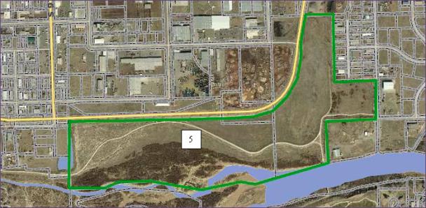
(b) Potential Concepts for Whitman and Emerson Parks.
(1) Provide for a diversity of uses to create a higher level of utilization.
(2) Minimize the impact of adjacent streets and automobile traffic.
(3) Activate the edges of the parks with mixed use.
(4) Contemplate programmed, active use.
(5) Redevelop as more active, flexible urban open space rather than as passive, green parks.
(Ord. 4571, 3-20-13)
36.16.100 City-owned Jarvis property.
The City completed an initial planning analysis for the City-owned property on the west side of 5th Street between the Colorado River and the Riverside Parkway known as the Jarvis Property. The property is constrained by natural features and the encroachment of the Parkway, but does have approximately 43 acres of developable land.
The initial study was to chart a direction for revitalization of the property. It summarized the key assets, identified some important issues and potential impediments to development, analyzed current market conditions and outlined a concept for organizing potential development of the property. The property and potential project are viewed as a unique opportunity for the City to chart the future of a rare property type, a place where it may be possible to provide a mix of uses, including residences, along the bank of the Colorado River. The major opportunities and constraints identified for potential development of the Jarvis Property were to: continue the riverfront greenway through the property, restore habitat, relocate the high voltage power facilities that run through the site, and provide flood protection for the property.
(Ord. 4571, 3-20-13)