


Chapter 39.12
FUTURE LAND USE AND ZONING
Sections:
39.12.020 Neighborhood and village centers.
39.12.030 Changes to the Comprehensive Plan Future Land Use Map.
39.12.050 Industrial development.
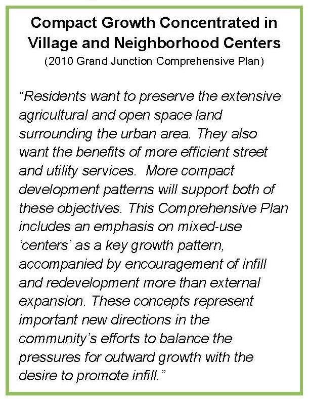
39.12.060 2010 Comprehensive Plan goals and policies.
39.12.070 Orchard Mesa future land use and zoning.
39.12.010 Background.
(a) In 2010 the City of Grand Junction and Mesa County adopted the Grand Junction Comprehensive Plan, which identified a range of densities on Orchard Mesa (Figure 3; Appendix Map 4). The land within the Urban Development Boundary (UDB) allows urban densities to develop as the urban core moves outward. As development occurs within the Persigo sewer service boundary, annexation into the City of Grand Junction is required, and urban services are provided. The area that is within the UDB is transitional, with some rural properties intermixed within urban areas. It is expected that some of these rural land uses within the urbanizing area will continue for years to come. It is important to recognize the right of agricultural uses to continue until the property is developed.
Figure 3: 2010 Comprehensive Plan Future Land Use Map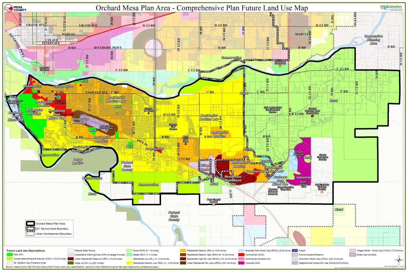
(b) During the 2010 Comprehensive Plan’s public process the public spoke about many priorities including:
(1) Locating future urban growth of high intensity/density adjacent to Highway 50;
(2) Preserving the river corridor as open land;
(3) Developing trails;
(4) Supporting cottage industries over other commercial and industrial land uses in the area;
(5) Preserving orchards and vineyards;
(6) Preserving agricultural land; and
(7) Limited industrial land on Orchard Mesa.
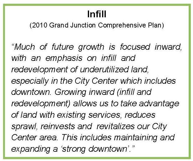
(c) Zoning districts implement the future land use map and the goals and policies of the Comprehensive Plan (Appendix Map 5). One of the guiding principles of the Comprehensive Plan is to have sustainable growth patterns in order to expand services efficiently and cost-effectively. The desired development pattern is to develop infill areas first, where it is most economical to extend and provide services, and then outward in a concentric pattern, rather than leapfrogging and developing beyond urban neighborhoods. Redevelopment of existing underdeveloped properties allows property owners to take full advantage of allowed land uses and densities as well as existing infrastructure (Appendix Map 7).
(d) In 2011, a sewer line was installed along 32 Road (Highway 141) connecting the community of Whitewater to Clifton Sanitation District. Some urban development along this corridor with existing commercial and industrial zoning already in place can be served by this sewer line. However, the presence of the sewer service line is not intended to be used to urbanize the entire corridor area in the immediate future.
(Ord. 4629, 5-7-14)
39.12.020 Neighborhood and village centers.
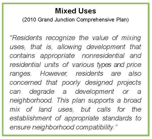
The future land use map of the Comprehensive Plan identifies village and neighborhood centers, which will have commercial and residential land uses mixed within a more densely populated environment. Village centers are generally larger in area and intensity than neighborhood centers. Two of these centers are identified on Orchard Mesa, a neighborhood center in the vicinity of the fairgrounds and a village center near 30 Road (Appendix Map 4).
The village center development identified in the 2010 Comprehensive Plan would be directed to the southeast end of Orchard Mesa along Highway 50 between 30 Road and Highway 141. A mix of uses is allocated to the area: commercial, retail, office and residential uses. Densities are highest near the core of the village center and decrease as distance from the core increases.
The village center is not expected to be developed until Orchard Mesa has seen sufficient growth and services have been extended to the area. Based on existing growth trends, this is not expected until well beyond the year 2020. The Comprehensive Plan looked at growth needs for the doubling of the 2010 population for the valley including a time when Whitewater has grown into an urban community with a village center. Doubling of the population is not expected to occur until after 2040.
The neighborhood center on Orchard Mesa is located at B 1/2 Road and Highway 50 where there is an existing City Market grocery store and other neighborhood businesses and services. The Comprehensive Plan envisions this area as having a mix of land uses, including higher-density residential development along with more services. The neighborhood center serves Orchard Mesa residents as well as those visiting the fairgrounds or just passing through.
 Sometimes conflicts between existing zoning and the designated future land use need to be resolved before development occurs. For example, there have been inconsistencies between land use and zoning in the area of the neighborhood center on Highway 50 at B 1/2 Road, including some adjacent lands along the corridor as well as the Mesa County Fairgrounds. In Grand Junction, these conflicts are resolved prior to development, either by amending the future land use or by rezoning. Mesa County requires rezoning to be consistent with the future land use map and Mesa County Master Plan.
In 2010, the fairgrounds was designated a mixture of Neighborhood Center, Residential Medium High, Residential Medium and Park in the Comprehensive Plan. Since 2010, a master plan for the fairgrounds has been adopted. Designating the fairgrounds as one future land use that best facilitates the implementation of the fairground’s master plan is preferred. Planned unit development zoning governs the use of the fairgrounds property in unincorporated Mesa County.
Based on further analysis, the neighborhood center would be better delineated as the triangular-shaped area north of Highway 50, south of B 1/2 Road, east of 27 1/2 Road and west of 28 Road. There are additional properties adjacent to or near this area that should be considered for inclusion in the neighborhood center and others best delineated as commercial for highway-oriented land uses outside the center.
(Ord. 4629, 5-7-14)
39.12.030 Changes to the Comprehensive Plan Future Land Use Map.
(a) The current configuration of the neighborhood center includes the fairgrounds as part of the center and there are existing conflicts between the Future Land Use Map and current zoning for some properties. The Orchard Mesa Neighborhood Plan seeks to remedy these by changing the Comprehensive Plan’s Future Land Use Map with the adoption of this plan (Figure 4; Appendix Map 6).
Figure 4: Neighborhood Center Future Land Use Changes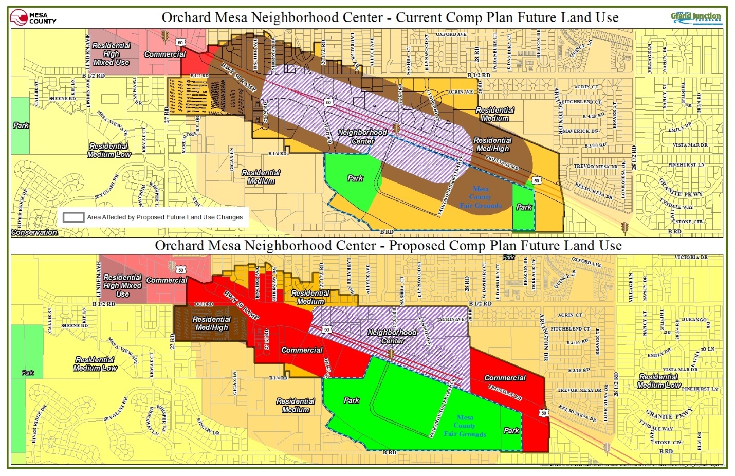
(b) The Future Land Use Map amendment:
(1) Changes the land use designations for the County Fairgrounds to “Park,” which better facilitates the implementation of the fairgrounds master plan and supports current zoning;
(2) Adjusts the boundary of the neighborhood center to include the area north of Highway 50 only, between 27 1/2 Road and 28 Road and south of B 1/2 Road;
(3) Changes several properties located east and west of the neighborhood center to a “Commercial” designation supported by existing zoning; and
(4) Establishes one land use designation on properties that currently are shown having more than one land use designation.
(c) Significant development and redevelopment opportunities exist along the Highway 50 corridor, which can also further the goals for Economic Development and Community Image. Future land use designations and existing zoning is in place that will support a sustainable growth pattern.
(d) A Mixed-Use Opportunity Corridor is also shown along 29 Road. This 29 Road corridor is intended to allow small neighborhood-serving commercial and mixed-use development, primarily around intersections but with an emphasis on blending with surrounding residential development.
(e) A commercial corner and medium density residential area is designated adjacent to the future school site at 30 1/2 Road and B Road. Additional schools and parks should be located in the village center vicinity. The village center could also be a prime location for a regional park in this quadrant of the Grand Junction community.
(Ord. 4629, 5-7-14)
39.12.040 Annexation.
The Comprehensive Plan set priorities for growth of the urban area and annexation into the City of Grand Junction. Specifically, “The extensive public input of this Comprehensive Plan indicated strong support for Grand Junction to grow in a sustainable, compact pattern. To accomplish this objective, rather than continuing to grow in a random fashion (that is inefficient to serve), the Comprehensive Plan identifies priority growth areas to focus the extension of new infrastructure and development.” (Comprehensive Plan, page 29) For Orchard Mesa, the prioritization is based on accessibility to existing infrastructure, adequate access, the existence of sub-area plans and proximity to existing commercial and employment areas. Areas of Orchard Mesa classified as infill or vacant and underutilized properties that may accommodate infill development including the creation and/or expansion of centers are part of the Comprehensive Plan’s Priority 1. The Priority 2 area includes Central Orchard Mesa within the 2008 Persigo Boundary (201 service area), which extends east to 30 Road (Figure 5; Appendix Map 1). Priority 3, which includes development east of 30 Road to 31 Road, discourages new urban development until 2020 or when appropriate circumstances exist.
Figure 5: Priority Areas for Development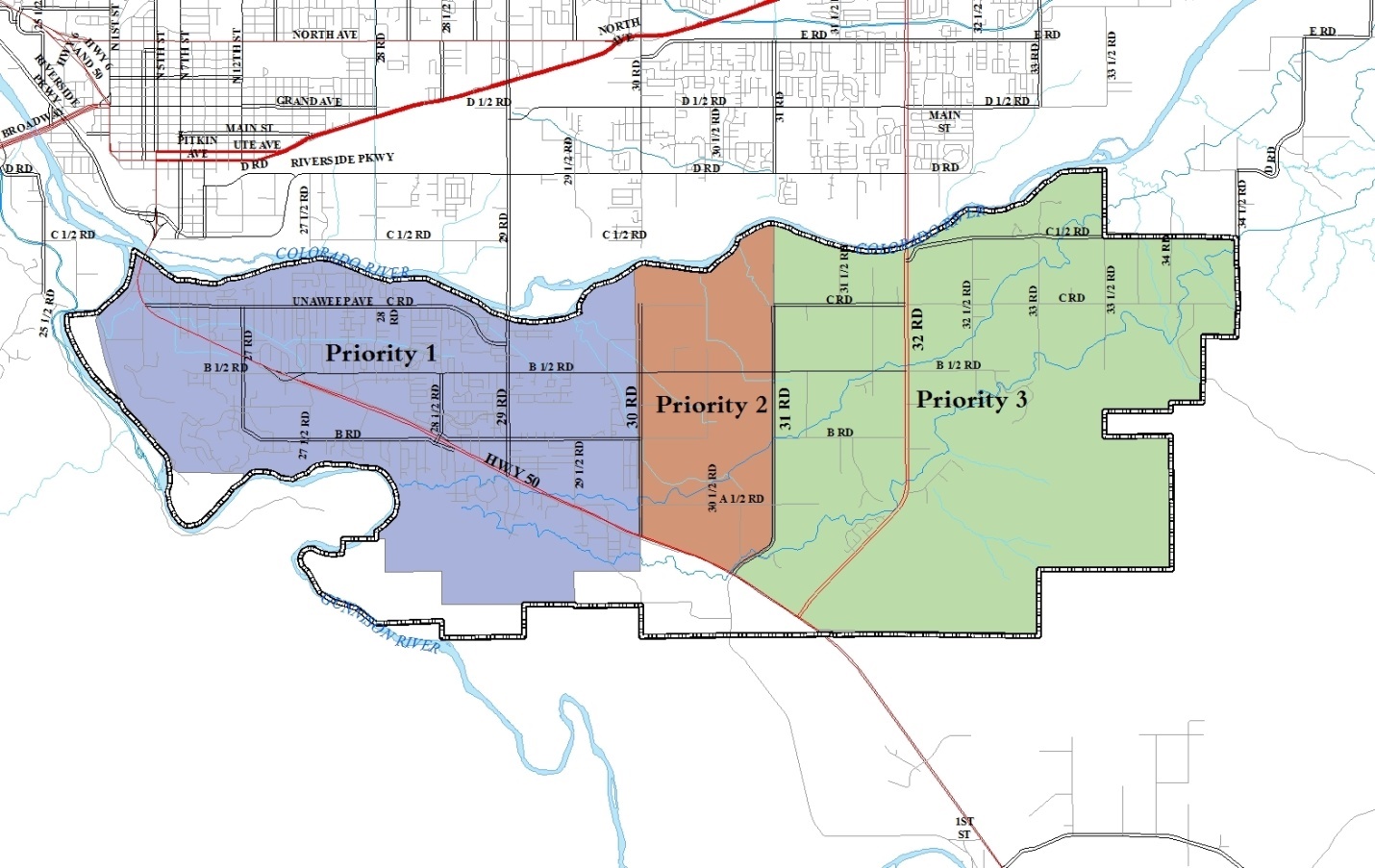
(Ord. 4629, 5-7-14)
39.12.050 Industrial development.
Orchard Mesa residents have voiced concern regarding increasing the amount of area for future industrial uses on Orchard Mesa. This sentiment was expressed during the 1995 Orchard Mesa Plan planning process and again during the 2010 Comprehensive Plan process. A large area in the Whitewater area was identified for future industrial businesses as part of the 2007 Whitewater Community Plan. With this industrial acreage in close proximity to Orchard Mesa, only a small area of industrial lands on Orchard Mesa was designated on the 2010 Comprehensive Plan’s Future Land Use Map. This small area includes land in and near the Springfield Estates subdivision located adjacent to Highway 141 (32 Road). The combinations of these lands should accommodate the industrial needs in the southern portion of the Grand Junction urban area. Adding more industrial uses than what has been established on the Future Land Use Map could trigger other issues affecting the industrial market and create additional neighborhood impacts.
The following graphic taken from the Comprehensive Plan depicts the differences between the different types of commercial and industrial land uses:
(Ord. 4629, 5-7-14)
39.12.060 2010 Comprehensive Plan goals and policies.
(a) Goal 3. The Comprehensive Plan will create ordered and balanced growth and spread future growth throughout the community.
(1) Policies.
(i) To create large and small “centers” throughout the community that provide services and commercial areas.
(ii) Create opportunities to reduce the amount of trips generated for shopping and commuting and decrease vehicle miles traveled, thus increasing air quality.
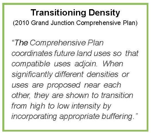
(b) Goal 7. New development adjacent to existing development (of a different density/unit type/land use type) should transition itself by incorporating appropriate buffering.
(1) Policies.
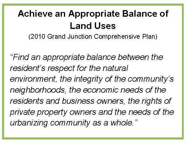
(i) In making land use and development decisions, the City and County will balance the needs of the community.
(Ord. 4629, 5-7-14)
39.12.070 Orchard Mesa future land use and zoning.
(a) Goal 1. Development is consistent with the land uses identified on the Future Land Use Map. Infill areas are developed first and then development occurs concentrically out toward rural areas, limiting sprawl.
(1) Actions.
(i) Create and implement an infill and redevelopment boundary, with incentives encouraging infill development and concentric growth. Possible programs may include:
(A) Charging development impact fees based on location;
(B) Offering density bonuses.
(ii) Continue to allow existing agricultural operations within the Urban Development Boundary.
(b) Goal 2. Outside of the Urban Development Boundary, agricultural uses are valued and protected as an important part of the Orchard Mesa economy and community character.
(1) Actions.
(i) Help maintain viable agricultural uses.
(ii) Implement incentive programs such as the existing Orchard Mesa Open Lands Overlay District that preserve open space, sensitive natural areas, irrigated agricultural lands, and the rural character.
(iii) Minimize conflicts between residential and agricultural uses. Require sufficient buffering for new development adjacent to agricultural land uses.
(iv) Encourage residential development on land that is unsuitable for agriculture and where services are available consistent with the Future Land Use Map.
(Ord. 4629, 5-7-14)