


Chapter 18.55
ZONING OVERLAY DISTRICTS
Sections:
18.55.030 Plan commission approval.
18.55.040 Downtown overlay district.
18.55.050 Indianapolis Boulevard overlay district.
18.55.010 Purpose and intent.
(A) The purpose of this chapter is to establish consistent procedures and standards for certain areas in the town of Highland that are unique or require additional consideration due to their character or importance to the town’s economic well being. The overlay districts will assist Highland to promote and protect the public health, safety, comfort, convenience and general welfare in these special areas while meeting the goals established in the comprehensive plan.
(B) The overlay districts will further serve as a means to implement the development policies and guidelines set forth in the comprehensive plan. As such, the purpose of the overlay district in the town of Highland is:
(1) To foster development conditions which promote aesthetic enhancement of designated areas and encourage sound planning.
(2) To provide a consistent urban design treatment for private and public uses and properties located in the overlay district.
(3) To foster additional opportunities for investment and reinvestment of real estate by allowing higher intensity of development.
(4) To preserve the integrity of certain transportation corridors in the town through access management planning and other improvements.
(5) To expand opportunities to create high level development through sound land use practices.
(C) Intent. It is the purpose of this overlay zoning district to ensure that buildings relate appropriately to surrounding developments and streets and create a cohesive visual identity and attractive street scene around the downtown area and its surrounding streets as a premier mixed use district whose viability, quality, and character is important to the town. It is further the intent of this overlay district to preserve the architectural and aesthetic qualities of the adjoining properties by:
(1) Providing appropriate standards to ensure a high-quality appearance for the overlay district and promote pedestrian-friendly design while permitting individuality, creativity, and artistic expression.
(2) Encouraging development and redevelopment that contains a compatible mix of residential and nonresidential uses within close proximity to each other, rather than separating uses.
(3) Promoting flexibility to encourage quality, scale, and character of development consistent with downtown’s existing or planned uses. [Ord. 1659 § 1, 2017].
18.55.020 General provisions.
(A) Applicability.
(1) The overlay district is created as a special area to be superimposed on the underlying districts by approval of the town council as appropriate.
(2) Boundaries of the overlay district(s) are shown on the zoning map but may be modified from time to time by the town of Highland.
(3) Development standards provided herein are intended to supplement those permitted in the underlying zoning classification and in most cases may be more restrictive than those of the underlying zoning district.
(4) The development of properties which are located in one or more overlay districts shall be subject to the requirements of both overlay districts and the underlying district in which they are located.
(5) When the requirements of the underlying zoning district and the overlay district appear to be in conflict, the more restrictive requirement shall apply.
(6) Wherever there exists a conflict between the requirements of the underlying zoning and those of the overlay district, the requirements for the overlay district shall prevail.
(B) District Boundaries, Zoning Map. The plan commission shall recommend the boundaries of the overlay districts as part of their establishment. Such boundaries shall be delineated on the zoning map, with the identifying name(s).
(C) The following overlay zoning districts shall apply to properties in the town of Highland as specified in the description of each district in this title:
(1) Downtown overlay district.
(2) Indianapolis Boulevard overlay district.
(D) Permitted Uses. All uses that are permitted, nonpermitted, or conditioned in any underlying zoning district to which an overlay district is applied shall remain as a permitted, nonpermitted or conditioned use unless otherwise specified by the applicable overlay district(s).
(E) Lot, Yard, and Development Standards. Any lot, yard, or development standards established by an overlay district shall apply as follows:
(1) All lot, yard, and development standards established by an underlying zoning district shall apply unless alternate standards are provided by the overlay district(s).
(2) Properties located in any overlay district(s) shall be subject to any additional lot, yard, and development standards established by the overlay district(s).
(3) If a parcel of land or subdivision lot was recorded prior to the effective date of the ordinance codified in this title and said parcel or lot does not contain the minimum area required by the standards of the overlay district, said undersized lot may be used for any use permitted in the overlay district; provided, that:
(a) At the time of recordation of the undersized lot or on the effective date, the undersized lot met the requirements for minimum lot size then in effect for a lot in the underlying zoning district(s).
(b) The owner of the undersized lot must include any adjoining vacant land (not separated by a street or public way) owned or owned by an affiliate on or before the effective date or at the time of application which, if combined with the undersized lot, would create a parcel which conforms, or more closely conforms, to the requirements of this title.
(c) All other requirements applicable to the overlay district can be met.
(4) If a lot is located both inside and outside of an overlay district, a development plan shall be submitted to the town for the entire lot.
(5) The requirements of this subsection do not preclude the sale or other transfer of any lot within a parcel after the approval of a development plan for the entire parcel. However, the development of the lot shall conform to the development plan for the entire parcel as approved or amended by the plan commission and all other applicable requirements of this zoning ordinance.
(F) Planned Unit Development District. Planned unit developments shall be subject to the requirements of any overlay district, if they are located within an overlay district, and shall be consistent with the requirements of this title.
(G) Performance Standards. In no instance shall any overlay district provisions be interpreted as modifying any performance standards established for the underlying zoning districts in this title.
(H) Accessory Uses and Buildings. Uses and buildings shall be approved by the plan commission during the development plan review upon the applicant demonstrating that the accessory uses and buildings will complement the primary use. Accessory building(s) in any proposed development plan shall have on all sides the same building proportions, architectural features, construction materials, and in general be architecturally compatible with the principal building with which the accessory use or building is associated. [Ord. 1659 § 1, 2017].
18.55.030 Plan commission approval.
(A) Development Plan. Any owner of property in the overlay district shall submit a development plan for review and approval by the plan commission. The plan commission shall review such plan for compliance with the provisions of this title. The commission’s review shall include, but not be limited to, the following items:
(1) Existing site features, including topography and natural areas.
(2) Zoning of the property.
(3) Surrounding zoning and existing land use.
(4) Access to public streets.
(5) Streets, curbs and gutters, sidewalks, and bicycle paths.
(6) Driveway and curb cut locations in relation to other sites.
(7) General vehicular and pedestrian traffic.
(8) Vehicle and bicycle parking facilities and internal site circulation.
(9) Special and general easements for public or private use and future linkage.
(10) On-site and off-site surface and subsurface storm water drainage including drainage calculations.
(11) On-site and off-site utilities.
(12) Dedication of streets and rights-of-way, or reservation of land for future development of streets and rights-of-way or public access.
(13) Proposed setbacks, site landscaping and screening, and building placement.
(14) Exterior architectural features, site amenities and landscaping including public spaces and design features.
(15) Efficiency in use of land and development of mix of uses.
(16) Project signage and lighting.
(17) Protective restrictions and/or covenants.
(18) Compatibility of proposed development with existing developments in the district.
(19) Consistency with the policies for the overlay district which are set forth in the comprehensive plan, including the thoroughfare plan and subarea plans.
(B) Bicycle and Pedestrian Access. The development plan shall include specific provisions for incorporating pedestrian and bicycle access, circulation and amenities into the development. Such bicycle and pedestrian access considerations shall include linking pedestrian and bicycle facilities to adjacent development, if feasible, and the Highland overall system of bicycle and pedestrian trails and routes.
(C) Findings for Approval by the Plan Commission. The commission shall make written findings concerning each decision to approve or disapprove a development plan after a public hearing. The commission may approve a development plan upon finding that:
(1) The development plan complies with applicable standards of the underlying district in which the lot is located.
(2) The development plan complies with applicable provisions of the appropriate subdivision control ordinance.
(3) The development plan complies with all applicable provisions of the overlay district including those specified in architectural design standards provisions for each respective overlay district.
(4) The proposed development is appropriate to the site and its surroundings.
(5) The proposed development is consistent with the intent and purpose of this title and the Highland comprehensive plan.
(D) Remodel, Expansion, or Improvement of Existing Structure or Parcels. If a lot is improved or an existing structure is expanded or remodeled within the overlay district, then that lot or structure shall be subject to the regulations contained in this title, except as provided in subsection (E) of this section.
(E) Exempt Waiver.
(1) The plan commission may, after a public hearing, grant a waiver of certain development requirements or standards of this chapter, as described herein. Any approval to permit such a waiver shall be subject to the following criteria:
(a) The development plan shall be in concert with the general purposes, land use and architectural standards provided in this title.
(b) The approval shall enhance the overall development plan, the adjoining streetscapes and neighborhoods, signage and the overall district.
(c) The waiver shall not adversely affect emergency vehicle access or deprive adjoining properties of adequate light and air.
(d) The approved waiver shall not produce a site configuration or street/circulation system that would be impractical or detract from the appearance of the development plan and the overlay district.
(e) The proposal employs extraordinary site design enhancements or amenities, including, but not limited to:
1. Enhanced landscape treatments.
2. Installation of public art or other aesthetic and artistic expressions.
3. Provisions for bicycles, pedestrians and/or mass transit.
4. Creation of public plazas, open space and other socialization features.
5. Removal, relocation, or improvement of undesirable or nonconforming signage.
6. Reduced surface parking in conjunction with provisions for above or below grade parking facilities.
7. Preservation of sensitive natural resources.
(2) In granting a waiver, the plan commission may impose such conditions that will, in its judgment, secure the purposes of this title. This subsection, however, does not affect the right of an applicant under Indiana law to petition the board of zoning appeals for a variance from development standards, as provided in IC 36-7-4-918.5 and this zoning ordinance.
(3) No development plan approval is required for the renovation, addition or expansion of existing structures provided such renovation, addition or expansion:
(a) Continues the architectural design of the existing structure, including exterior color and materials; doors and windows, other detailing.
(b) Is attached to the existing structure. Does not exceed 10 percent of the original gross floor area of the existing structure.
(c) Meets the requirements of the underlying zoning district.
(d) Has received a prior development plan approval from the plan commission.
(F) Validity of Approval of the Application by the Plan Commission. An approved development plan petition shall be valid for one year from the date of approval. If construction of the building(s) has not started at the end of the one-year period, the development plan request shall be resubmitted to the plan commission for consideration and disposition.
(G) Extensions. One extension, for accomplishing any processes required by this title, or for resuming construction activity in an abandoned development, may be granted by the plan commission upon a written request from the owner. The extension length shall not exceed one year for a new development or six months for a new development phase of a continuing project. All requests for extensions must occur a minimum of 60 days prior to the applicable expiration time of the application.
(H) Removal of a District. Nothing in this title shall be deemed to deny the plan commission the power to remove an overlay designation from one or more parcels by the rezoning process described in this title. Such removal may be done by modifying the boundary map. [Ord. 1659 § 1, 2017].
18.55.040 Downtown overlay district.
(A) District Boundaries. The boundary of the downtown overlay district shall be established as follows, and as delineated in Exhibit 15: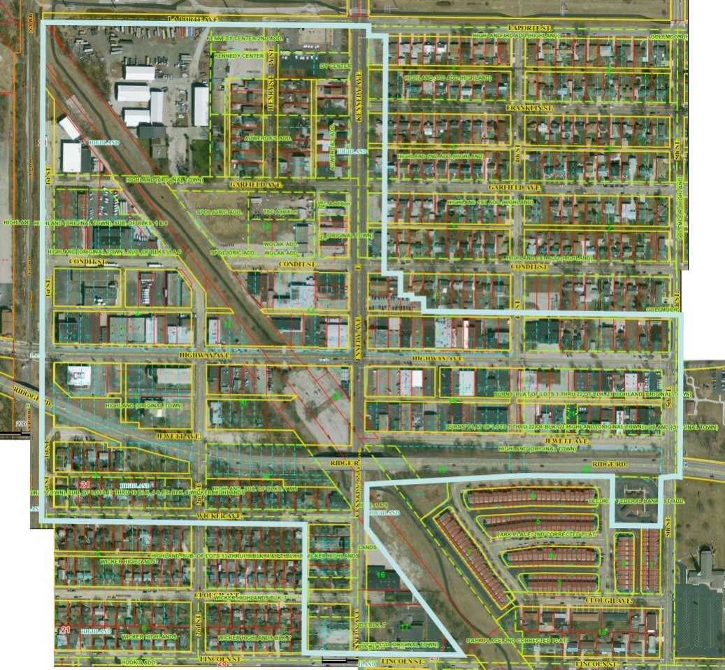
Exhibit 15 – Map of Downtown Overlay District
Beginning at the northeast corner of intersection of the south right of way (ROW) line of Ridge Road and east ROW line of Kennedy Avenue; thence east along the south Ridge Road ROW line approximately 640 feet; thence continuing along the south ROW line approximately 385 feet to the northwest corner of Security Federal Bank 1st Addition to the town of Highland; thence south along said west line 179.78 feet to a tangent curve concave to the northeast; thence around said curve 39.08 feet; thence following the south subdivision line easterly 175.19 feet to the west ROW line of Fifth Street; thence north along the west ROW line of Fifth Street approximately 200 feet to the south ROW line of Ridge Road; thence northeasterly, to southeast corner of Fifth Street and Ridge Road (which has a reduced ROW width on the east side of Fifth Street); thence east along said south line 20 feet to the east ROW line of Fifth Street extended; thence north along said east line approximately 444 feet to the south ROW line of Highway Avenue; thence east 10 feet along said south line to the east line of Fifth Street extended from the north; thence north along said east line approximately 238 feet to the extended limit of a dedicated alley laying between and parallel to Condit Street and Highway Avenue; thence westerly along said north alley line approximately 1,082 feet to the east line of Lot 5 in Block 13 in the Highland (Original Town) Subdivision; thence northerly along said lot line approximately 53 feet to a divided lot line; thence westerly 48.3 feet to the west line of said Lot 5; thence north along said west line approximately 12 feet to a line dividing Lot 4 in said subdivision; thence westerly along said line 48.3 feet to the west line of said Lot 4; thence north along the westerly line of said Lot 4, a distance of approximately 89 feet to the south ROW line of Condit Street; thence westerly on said south line 64.52 feet to the extended east lot line of Lot 22 in the Highland 1st Addition Subdivision Plat, thence northerly approximately 902, along the east lines of Lots 22 and Lots 1 in said Highland 1st Addition subdivision, in Highland 2nd Addition Subdivision, and Highland 3rd Addition subdivision to the south ROW of Laporte Street; thence west 71.84 feet along the south ROW of Laporte Street to the east ROW line of Kennedy Avenue; thence north along said east ROW line, 40 feet to the extended south ROW line of Laporte Avenue (extended from the west); thence west along said ROW line and extended line a distance of approximately 1,365 feet to the east ROW line of the Norfolk Southern Railroad; thence south along said east line approximately 2,080 feet to the south ROW line of Wicker Avenue extended; thence east along said south ROW line approximately 1,093 feet to the western line of a dedicated alley; thence south on said west alley line approximately 540 feet to the north ROW line of Lincoln Street; thence east on said north ROW line approximately 664 feet to the west line of a Northern Indiana Public Service Company (NIPSCO) corridor; thence along said western ROW line northwesterly 261.5 feet; thence east 14.5 feet; thence northwesterly 403.55 feet to the east ROW of Kennedy Avenue; thence north along said east line approximately 172 feet to the south ROW line of Ridge Road and the Point of Beginning.
(B) Permitted Uses. In addition to all uses permitted in the underlying primary zoning district(s), the following uses are permitted:
(1) Residential mixed uses.
(2) Commercial mixed uses consisting of office and retail uses, provided residential uses are located on second floor or higher.
(C) Excluded Uses. The following uses are not permitted in the downtown overlay district:
(1) Single-family detached residential housing north of Ridge Road.
(2) Single-use retail.
(3) Industrial uses.
(4) Any use permitted solely in a B-3 general commercial district.
(5) Cell towers and other wireless communication facilities.
(6) Equipment sales and service.
(7) Strip commercial development.
(8) Construction and related uses with open yards.
(9) Off-site parking lots.
(10) Other similar uses where heavy reliance on cars or open yard storage is required.
(D) Accessory Buildings and Uses. All accessory buildings and uses which are permitted in the underlying primary zoning district(s) shall be permitted, except that any accessory building shall have on all sides the same building and architectural features, construction materials, and in general be compatible with the principal building(s) with which it is associated.
(E) Lot, Yard, and Development Standards.
(1) Except as provided herein, the minimum area required for development in the downtown overlay district shall be 3,125 square feet.
(2) Front yards shall be as provided in the underlying primary zoning district. In nonresidentially zoned districts, an additional 10-foot setback may be provided from the front property line if a courtyard, porch, stoop, plaza, or seating area is incorporated into the development adjacent to the public street.
(3) Side and Rear Yards.
(a) The underlying primary zoning requirements shall apply for side and rear yards, except that the required rear yards shall be five feet for all lots fronting Highway Avenue, Kennedy Avenue, and Jewett Avenue.
(b) Where appropriate and practical, alleys between buildings shall be required for the provision of public connections between buildings, access to parking, open space, and streets.
(4) Building heights shall be as provided in the underlying primary zoning district except as established herein.
(a) Minimum Building Height. Minimum height of 35 feet and two occupiable floors. In commercial and mixed-use buildings, the first floor shall be solely devoted to retail or office uses.
(b) Maximum Building Height. Maximum height of 60 feet or four occupiable floors.
(5) The minimum lot width shall be 25 feet for all lots fronting Highway Avenue and Jewett Street. In all other areas, the underlying primary zoning requirements shall apply.
(6) New developments shall have a minimum of 2,500 square feet of gross floor area, excluding the area of any basement or accessory building(s). The first floor area may be assigned a larger portion of the total floor area if it is used for commercial purposes.
(7) The maximum lot coverage shall be 90 percent for all lots fronting Highway Avenue, Kennedy Avenue, and Jewett Avenue. The lot coverage may be increased to 100 percent for mixed-use buildings when parking garages are provided or for a renovated structure. In all other areas, the standards of the underlying zoning district shall apply.
(F) Architectural Design Standards. The intent of this section is to preserve the unique character of the district, complement the existing historic architecture, enhance the pedestrian orientation and encourage streetscape design that is inviting and on a human scale. It is further intended to communicate the community’s vision for the area. The goal is not to dictate a particular design, but rather to encourage innovation in building design, placement, as well as orientation. In reviewing the architectural design of building(s) and sites proposed in the downtown overlay district, the regulations set forth in HMC 18.40.060 shall apply. In addition, the plan commission shall also consider the following provisions:
(1) Context.
(a) All buildings shall be designed to meet the historical and traditional character of the district, particularly with due consideration to buildings located on lots that abut the right(s)-of-way of Highway Avenue, Kennedy Avenue, and Jewett Avenue. Development of buildings and sites with modern style architecture design and energy conservation is encouraged.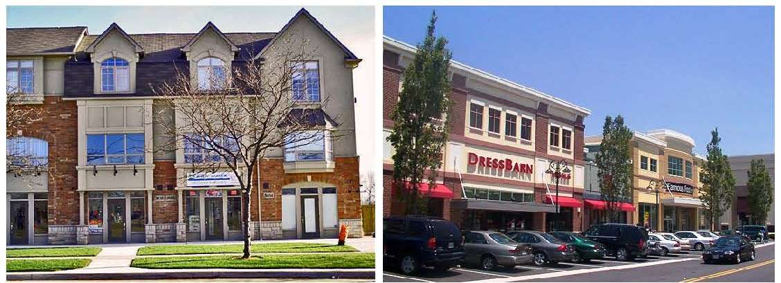
Exhibit 17 – Examples of Acceptable Architectural Styles
(b) Buildings shall be designed and constructed to be LEED certified or equivalent.
(c) Franchise architecture shall not be permitted. Franchises or national chains shall follow recommended architectural styles to create a unique building that is compatible with the traditional downtown character.
(2) Scale and Proportion.
(a) All building facades, including doors, windows, column spacing, and signage shall be designed to promote human scale and proportions.
(b) A single, unbroken structure mass and facade shall be avoided in new construction and, to the extent reasonably feasible, in redevelopment projects involving changes to the mass of existing structure.
(c) New buildings shall be articulated with such means as expressed structure, window bays, piers and columns, and varied building setbacks.
(d) Horizontal masses shall maintain a height to width ratio of 1:3 without substantial variation in massing that includes a change in height and projecting or recessed elements.
(e) Wall elevations greater than 50 feet in length shall incorporate regular interruptions in the wall plane by projections or recesses having a depth of not less than two percent of the length of the wall. Such projection or recession shall extend for at least 20 percent of the length of the wall.
(f) Corner buildings with frontage on Highway Avenue, Kennedy Avenue, or Jewett Avenue shall cover 100 percent of the permitted frontage of the front lot.
Exhibit 18 – Example of Varied Building Articulation
(3) Detailing. New construction and renovation shall carefully consider the style and character of the existing buildings to establish an appropriate level of detail for facades, roof lines, windows, doors, porches, entry points, railings, sidewalks, and public spaces. New buildings can be modern in design, but must reflect the same richness in detailing and character as found in the overlay district as a whole.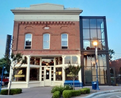
Exhibit 19 – Example of Building Detailing
(4) Building Materials.
(a) Structures taller than two stories shall have a facade primarily consisting of brick, masonry, stone, terracotta, and similar materials. A minimum of three different types of materials shall be used for such buildings. Other materials for accenting, such as architectural precast panels or detailing, architectural metal panels, glass, and ornamental metal, are encouraged.
(b) Large expanses of glass are not permitted, except for the ground floor, where the minimum glass area shall be 75 percent of the facade area for all nonresidential uses.
(c) Buildings constructed entirely of a metal or glass curtain wall are not permitted. Concrete block, split block masonry units, or precast concrete panels are not permitted as an exterior finish material on any side of the structures.
(5) Roofs.
(a) The roof form shall be designed to express the building and to promote the overall scale and character of the district.
(b) The roof form shall have a recognizable “top” and vary with the expression of parapets, gables, overhanging eaves, chimneys, brackets and cornices. Parapets shall be embellished with brick detailing and stepped or sloped to achieve a visually interesting yet harmonious sequence along the building facade.
(c) Where used, sloped roofs shall not extend more than 25 feet without a change in roof plane, or gable or dormer. Acceptable materials for sloped roofs include standing seam metal, dimensional shingles, or slate.
(d) Rooftop gardens and landscaping shall be encouraged on flat roof buildings to reduce storm water runoff and reduce the heat island effect in the district.
(6) Windows.
(a) Window placement shall be composed within a facade to create a balanced and well-proportioned facade that provides visual interest along all public rights-of-way.
(b) Window placement for buildings with office or commercial uses shall be designed to foster window shopping and promote those uses of the building. Ground floor buildings with office or commercial uses shall have a minimum of 75 percent glass openings.
(c) On upper floors, the windows shall be vertically oriented. Arched tops, columns framing the windows, and decorative lintels are encouraged. A minimum of 30 percent transparency in the upper floor facade shall be required.
(d) The use of opaque or reflective glass in windows is prohibited.
(7) Entryways.
(a) Buildings shall have a primary entrance door facing a public sidewalk.
(b) For all buildings that abut Highway Avenue, Kennedy Avenue, or Jewett Avenue, the primary entrance shall face and be directly accessible from those streets. In the case of corner lots, an additional public entrance may be provided from a crossing street.
(c) The maximum distance for the primary entrance to a building from the front right-of-way shall be 20 feet.
(d) Building entrances may include doors to individual shops or businesses, lobby entrances, entrances to pedestrian-oriented plazas, or courtyard entrances to a cluster of shops or businesses.
(e) Creative entry treatments such as canopies, awnings, cornice treatments, or atriums shall be incorporated in the building design to the extent practical.
(f) For nonresidential buildings, the rear elevation (facing associated parking or rear yard) shall be treated as a second front with glazed facade and signage similar to the building front to the extent practical.
(8) Site Design and Building Placement.
(a) All buildings shall be aligned along the edges of a lot. Articulation of the facade and setback to create front yard plaza is permitted.
(b) Building Setback. For business lots fronting Highway Avenue, Kennedy Avenue, or Jewett Avenue, the building line shall be set no more than 10 feet from the property line. This setback area may only be designed and used as public space area.
(c) Development sites and building placement for retail and mixed uses shall establish or enhance the traditional architecture by incorporation of at least one of the following elements for every 25 feet of frontage:
1. Pedestrian plaza with seating areas and outdoor features such as planters.
2. Water feature.
3. Clock towers, monuments or other similar features.
4. Public art.
5. Other deliberately shaped area or focal feature that enhances or creates public spaces.
(d) Any such areas shall have direct access to the public sidewalk and such features shall not be constructed of materials that are inferior to the principal materials of the structure and landscaping.
(9) Sidewalks.
(a) Public sidewalks shall be located along both sides of all streets. Sidewalks in residential districts shall be no less than five feet in width, and no less than 12 feet in width in all other districts, unless otherwise approved as part of the development plan review process. (See Exhibit 20.)
(b) Additional Standards in Nonresidential Districts. For sidewalks in nonresidential districts, the 12-foot minimum requirement shall apply regardless of the available right-of-way. Where required, the sidewalk shall extend onto private property to fulfill the 12-foot minimum requirement, with a sidewalk easement provided. Sidewalks shall consist of two zones: a street tree/furniture zone located adjacent to the curb, and a clear zone. The following standards shall apply for these zones:
1. Street Tree/Furniture Zone. The street tree/furniture zone shall have a minimum width of seven feet and shall be continuous and located adjacent to the street curb.
2. Clear Zone. The clear zone shall have a minimum width of five feet, be hardscaped, and located adjacent to the street tree/furniture zone. The clear zone shall comply with the Americans with Disabilities Act (ADA) and other accessibility standards and shall be unobstructed for a minimum width of five feet and a minimum height of eight feet.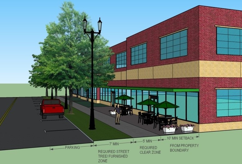
Exhibit 20 – Downtown Overlay District Sidewalk Standards
(c) Where uses include opportunities for outdoor gathering on the public sidewalk (cafes, restaurants, dining establishments, etc.), there shall be a minimum of five feet of continuous and linear clearance for safe passage by pedestrians.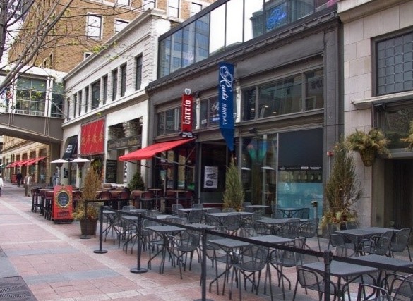
Exhibit 21 – Example of Pedestrian Clearance from Outdoor Seating
(10) Open Space.
(a) All new construction, redevelopment, or other lot improvements regardless of the size of the lot shall provide for a minimum of 10 percent open space on the lot, except as provided herein. The hardscape area or required green space in the underlying zoning district may be counted towards the open space requirements.
(b) Areas dedicated as open space shall be a minimum of five feet wide in their smallest dimension.
(c) Areas dedicated as open space shall be free of all structures and buildings except for structures directly related to the purpose of the open space such as seating areas, plaza, sculptures or public arts.
(d) Ownership and Maintenance of Open Space. Unless otherwise agreed to by the town, the maintenance responsibility and cost of dedicated land as open space shall be solely borne by the property owner.
(G) Landscaping. Landscaping treatments shall be used to enhance the pedestrian experience, complement architectural features and/or screen unattractive elements such as utility features. Use of flower boxes, planters and hanging flower baskets is encouraged. In addition to the applicable requirements of Chapter 18.75 HMC, the following provisions shall apply.
(1) Streetscape.
(a) The streetscape shall be uniform in design so that it provides a continuity throughout the district.
(b) When making improvements to public or private property, including the addition of benches, trash receptacles, fencing, or bike racks, owners shall match the town’s approved standards for these elements.
(c) Where a parkway area is paved, it shall follow the town’s public improvement guidelines or be based on a development plan approved by the plan commission.
(d) Existing parking lots facing a public right-of-way shall be screened by plant material or an architecturally compatible masonry wall a minimum of three feet and maximum of three feet, six inches in height. If a wall is proposed, the front elevation of such wall shall be landscaped with appropriate landscaping.
(2) Landscape Standards. In addition to the provisions of Chapter 18.75 HMC, the following landscape standards shall apply in the downtown overlay district:
(a) Street trees shall have a minimum of two-and-one-half-inch caliper, and where the street parkway is paved, trees shall be planted in engineered soil and have a five-foot-square cast iron tree grate.
(b) Front yards for residential land uses shall be landscaped with appropriate plant materials.
(c) Front yards for nonresidential or mixed uses may be landscaped for plazas with hard surface or other public uses, provided a plan is provided and approved by the plan commission.
(d) Foundation plantings shall not be required for commercial developments. However, the use of planters and flower boxes is encouraged and shall be counted as a part of the required landscaping.
(e) Parking lots with more than 30 spaces shall be divided into separate areas by landscaped islands of at least five feet in width. A minimum of 10 percent of all surface lots shall be landscaped.
(f) Parking lots shall be screened along all public rights-of-way by a landscaped buffer of not less than five feet wide, and a three-foot-six-inch-high wall. On all other sides, parking lots shall be screened with three-foot-high walls or fencing compatible with the adjacent architecture and five-foot-wide green buffer.
(H) Public Art.
(1) Public art that is included as part of a development plan shall be displayed in a location that is visually accessible to the public or visible from either Highway Avenue, Kennedy Avenue, Jewett Avenue, other crossing streets, or a public plaza.
(2) Public art shall not be required; however, a credit may be awarded for such installations by the plan commission equal to the total cost of public art in lieu of landscaping, but not to exceed more than 20 percent of the total landscaping cost.
(I) Parking. Parking in this overlay district shall be in accordance with provisions of Chapter 18.80 HMC, except as modified below.
(1) Required Number. The total number of parking spaces may be reduced based on an approved development plan. In approval of such plan, the following standards shall apply.
(a) Residential Uses. A minimum of one-half parking space shall be required per residential unit. A maximum of two spaces per unit may be provided if the additional parking spaces are structured.
(b) Nonresidential Uses. The number of off-street parking spaces required shall be a minimum of 40 percent to a maximum of 60 percent of the required number as provided by the underlying district. The maximum may only be exceeded if the additional parking spaces are structured (in a ramp, deck, underground, or within a building).
(c) Mixed-use buildings shall use shared parking to meet the requirements of this subsection.
(d) Bicycle racks shall be provided on any development at a ratio of one rack per five percent of the total required parking spaces.
(2) Access and Siting, Residential. Parking and garages shall be located in the rear yard for all single-family or multifamily residential uses and accessed from the side yard, rear alley, or a service drive.
(3) Access and Siting, Nonresidential.
(a) Off-street parking shall be located to the rear of the principal building within the rear yard area of the lot. Access to off-street parking areas shall be provided from the rear alley, side street, service drives, or shared with adjoining parking lots.
(b) All off-street parking areas and drives shall be paved with asphalt or concrete. Brick pavers or other decorative pavements may be used as accents in parking area design. Cast-in-place concrete curbs shall be provided.
(4) Pedestrian and bicycle access shall be coordinated with vehicular access, front yard design, and parking layout. Such pedestrian and bicycle access consideration shall include development and linkage with facilities in adjacent properties to the extent practical and the following provisions:
(a) Sidewalks shall be provided in all developments, and among all buildings and amenities within a development to the maximum extent possible.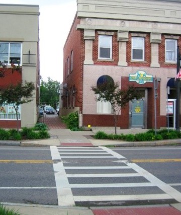
Exhibit 22 – Example of Pedestrian Linkages among Buildings
(b) Sidewalks shall be linked with all public streets, pedestrian trails, and transit facilities to the extent practical.
(c) Sidewalks shall connect to contiguous lots and abutting lots, and shall be coordinated and aligned to form a continuous pedestrian walkway network that serves adjoining developments.
(J) Signage. Development signs shall conform to the provisions of Chapter 18.85 HMC. In addition, the following provisions shall apply for the downtown overlay district:
(1) Signage shall be provided as an integral element of the architectural and site design. All signs to the development shall be complementary in their use of color, shape, and material, and shall enhance the buildings and other amenities or features on the site.
(2) To the extent practical, all signs shall be constructed of natural materials such as metal or wood.
(3) No signs shall extend higher than the height of the ground floor.
(4) No principal sign shall exceed 20 percent of the ground floor wall area. No other individual sign on the building (e.g., window sign) shall exceed 30 square feet in size.
(5) The distance between sign and building face shall not exceed one foot.
(6) Signs shall not block or obliterate design details, windows, or cornices of the building upon which they are placed.
(7) Permanently painted window signs are encouraged, provided they are compatible with the architecture of the building and do not consume more than 33 percent of the glazing area of the window.
Exhibit 23 – Example of Glass Painted Sign
(8) Temporary window signage shall be limited to 33 percent of the window surface area.
(9) Multi-tenant or multi-business development shall submit a signage plan for total development. This plan shall coordinate all signage on the site in a uniform manner. Sharing of signs to identify multiple businesses is required for multi-business developments in the overlay district. For such developments, one sign shall be permitted unless specifically provided in this title.
(10) Off-premises signs shall be prohibited in the downtown overlay district.
(11) Permitted Signs. In addition to permitted signs in the underlying district, the following signs are also permitted in this overlay district.
(a) Symbolic and historic three-dimensional signs such as projected signs, blade signs, and barber shop poles. Blade signs shall not be greater than six square feet, extend more than three feet from the building face, or have a vertical clearance of less than 10 feet.
(12) Prohibited Signs.
(a) Internally illuminated signs are prohibited, except for theater or approved marquee signs.
(b) All programmable display signs or all other similar digital signs are prohibited.
(13) Wayfinding Signs. Wayfinding signs shall be provided to direct traffic to destinations within this overlay district. Wayfinding signs shall meet the following standards.
(a) Signs shall be freestanding, uniform in design, and placed on interior drives, parkways, and intersections of such drives.
(b) Signs shall be limited in size to eight feet in height and five feet in width.
(K) Lighting.
(1) Lighting in the overlay district shall serve to illuminate facades, entrances and signage and provide an adequate level of personal safety while enhancing the aesthetic appeal of the buildings. Lighting shall be provided as an integral element of the architectural and site design.
(2) Parking lots, entry points, rear entrances, and buildings shall have uniform lighting.
(3) All fixtures, except security lighting, shall be full cutoff and shielded.
(4) Building and signage lighting shall be indirect, with the light source(s) hidden from direct pedestrian and motorist view. For exterior sign illumination, use of traditional fixtures such as shaded gooseneck lamps is encouraged.
(L) Other Requirements.
(1) Outside Storage.
(a) Open storage of materials, refuse, or equipment shall not be permitted in this overlay district. Outdoor display of merchandise or goods for sale or exhibit shall not be permitted on any property.
(b) All refuse collection containers shall be enclosed on three sides and shall be architecturally compatible with the primary building.
(c) Refuse collection, recycling areas, mechanical equipment and fixtures, and related uses shall be placed only in the rear side of the lot so as not to be visible from the public right-of-way. Such uses shall be fully screened on all sides in accordance with applicable screening requirements of this title. Mechanical equipment and fixtures shall be screened within a solid wall, with a minimum height of eight feet, and compatible with the materials used in the primary building.
(2) Loading areas, where required, shall be fully integrated into the building design and screened with landscaping in accordance with applicable screening requirements of this title.
(3) All utilities shall be underground. [Ord. 1659 § 1, 2017].
18.55.050 Indianapolis Boulevard overlay district.
(A) District Boundaries. The boundary of the Indianapolis Boulevard overlay district shall be established as follows, and as delineated in Exhibit 24:
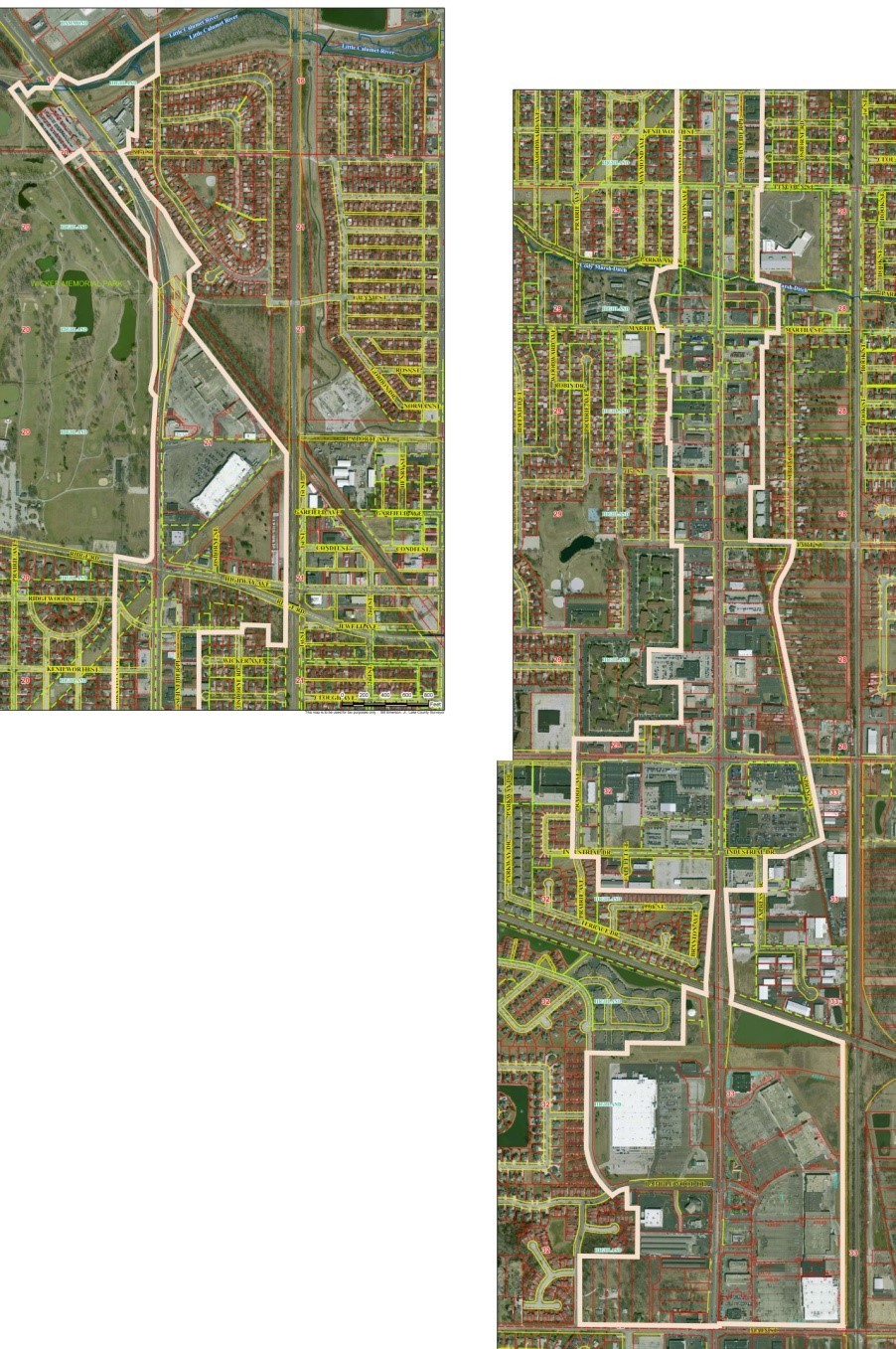
Exhibit 24 – Map of Indianapolis Boulevard Overlay District
Beginning at the southeast corner of the Highland Town Center subdivision in the town of Highland, Indiana, said corner also lying on the north right of way line of Main Street; thence north along the east line of said subdivision approximately 2,621 feet to south right of way (ROW) line of the Grand Trunk and Western Railroad; thence northwesterly along the south ROW line approximately 1,097 feet to the east ROW line of Indianapolis Boulevard; thence north approximately 106 feet, crossing the said railroad ROW to intersection of the north railroad ROW and the east ROW of Indianapolis Boulevard; thence northerly along said east ROW approximately 940 feet to the south line of parcel 45-07-33-103-001.000-026 in the Lake County Assessor’s Office; thence east along said south line 362.2 feet to the east ROW line of Express Drive; thence north along the east ROW line of Express Drive, 313.55 feet to the south ROW line of Industrial Drive; thence along the south and easterly ROW lines of Industrial Drive, east 181.48 feet and northeasterly 286.99 feet to the east ROW line of Spring Street; thence northwesterly along the east ROW line of spring Street approximately 785 feet to the north ROW line of 5th Street; thence west 20 feet to the east ROW of Spring Street; thence northwesterly on said east ROW line approximately 1,367 feet to tangent reverse curves concave to the east and west; thence along said curves approximately 395 feet to the north ROW line of Hart Road; thence west on said ROW line 393 feet to the west line of the Wojcik Addition subdivision (commonly known as Spring Creek Condominiums); thence north along the west line of said subdivision, 489.95 feet to the northwest corner of said subdivision; thence east along the north line of said subdivision to a point 225 feet from the centerline of Spring Street; thence north parallel to and 255 feet from the center of Spring Street approximately 1,302.5 feet to the south subdivision line of Schuyler Square South Subdivision; thence east along said south line approximately 103 feet to the southeast corner of said subdivision; thence north along the east line of said subdivision 130.41 feet to the south ROW line of Martha Street; thence east along the said ROW line approximately 107 feet to the east line extended of Schuyler Square Addition; thence north along said line approximately 432 feet to the north line of said subdivision; thence following the north subdivision line northwesterly approximately 163.6 feet; thence westerly approximately 37 feet to the east ROW line of Schneider Avenue extended; thence north along the said east ROW line approximately 840 feet to the south ROW line of Lincoln Street; thence east on the said south ROW line approximately 40 feet to the west line of Lincoln Addition subdivision extended; thence north along said west line approximately 885 feet to the south ROW line of Ridgewood Street; thence east on said south ROW line 400.08 feet to the east ROW line of Osbourne Drive; thence north on said east line and east line extended approximately 75 feet to the north subdivision line of Auwerda’s 3rd Addition; thence east along said subdivision line 240.07 feet to the east line of said subdivision; thence south on said east line approximately 182 feet to the north line of Jarchow’s Addition; thence east on said subdivision line, 158.75 feet to the west ROW line of the Norfolk Southern Corporation Railroad; thence north along said railroad right of way approximately 1,773 feet to the Northern Indiana Public Service Company (NIPSCO) utility corridor; thence following the corridor limits northwesterly, approximately 160 feet, west 50 feet, north 20 feet, northwesterly approximately 1,324 feet to the east ROW of Indianapolis Boulevard extended, thence northeasterly approximately 254 feet to a southwest corner of Wicker Park Manor, Resub of Lots 24 thru 41 Block5; thence northwesterly 31.78 feet to the irregular ROW of Indianapolis Boulevard; thence along said Indianapolis Boulevard ROW on several courses approximately 1,545 feet to the north ROW line of 81st Street, said line also being the south subdivision line of Emro Resubdivision of Lots 7 thru 13,20 & 21 of Block 4 Wicker Park Manor; thence following the subdivision limits on the following courses south line around a curve 86.59 feet, north 148.99 feet; southeast 58.03 feet; east 25.23 feet; north 433.42feet and north west 10.61 feet to a parcel of land (45-07-17-478-001.000-026) containing the Little Calumet River; thence along the south, east and north sides of said parcel; northwesterly approximately 224 feet, north approximately 360 feet, southwesterly 317 feet, southwesterly 289.87 feet; southwesterly approximately 270 feet; northwesterly 181.13 feet to the east ROW line of Indianapolis Boulevard; thence southeasterly 144.65 feet to the approximate centerline of the little calumet river; thence westerly 82.5 feet to the approximate centerline of Indianapolis Boulevard; thence southeasterly along said centerline 21.5 feet to the extended north line of a parcel 45-07-17-476-005.000-026; thence westerly, following the parcel lines approximately 255 feet; thence southeasterly approximately 13.5 feet; thence southwesterly approximately 98 feet; thence northwesterly 113 feet; thence southwesterly approximately 102 feet; to the west line of said parcel; thence southeasterly along said parcel line 257.07 feet to the northwest corner of parcel number 45-07-17-476-009.000-026; thence southeasterly on the western side of said parcel approximately 560 feet to the south line of parcel 45-07-20-226-002.000-026; thence northeasterly 199 feet along the said southeastern line to the southwestern line common to parcels 45-07-17-476-012.000-026, 45-07-20-226-006.000-026, 45-07-20-226-007.000-026 and 45-07-20-226-008.000-026, thence southeasterly along said line 656.36 to the southwestern ROW line of Indianapolis Boulevard; thence southeasterly along said ROW line following the next courses southeasterly approximately 365 feet, southerly approximately 382 feet, southeasterly approximately 55 feet, southerly approximately 750 feet; around a curve concave to the west approximately 50 feet; southwesterly 160 feet; around a curve concave to the northeast approximately 70 feet; southeasterly approximately 30 feet, around a curve concave to the southwest approximately 25 feet; southeasterly around a curve concave to the east approximately 436.5 feet; south approximately 1,273.5 feet and around a curve to the northwest 45 feet to a point tangent on the north ROW line of Ridge Road; thence westerly along the said north ROW line 237 feet to the extended west line of parcel 45-07-20-427-012.000-026 and the west line of Brantwood Addition Resub of Lots 2 thru 5 Block 1 a distance of approximately 370 feet to the north ROW line of Ridgewood Street; thence south 50 feet to the intersection of the south ROW line of Ridgewood Street and west Branton Avenue ROW line; thence south along said west ROW line approximately 1,880 feet to the north line of Cady Creek Condominiums of Schuyler Square West; thence following the said north and west subdivision lines west approximately 63.2 feet; thence southwesterly 95.55 feet; thence northwesterly 25.77 feet; thence southerly 241.67 feet to the northwest corner of Schuyler Square West Subdivision; thence continuing southwesterly along the west subdivision line of said subdivision 42.23 feet; thence southeasterly 235 feet to the north ROW line of Martha Street; thence south 50 feet to the south ROW of Martha Street; thence east on said ROW line approximately 93 feet to the west line of Fauth Addition Subdivision; thence south on the west subdivision line approximately 242 feet to the southwest corner of said subdivision; thence west approximately 48 feet to the east line of Myers Addition; thence south along said east line 131.84 feet to the north line of Waymond 2nd Addition; thence east along said north line approximately 63 feet to the northeast corner of said subdivision; thence south along the east line of said subdivision and the west line of Waymond 3rd Addition 133.22 feet to the north line of Waymond 4th Addition; thence east approximately 7 feet to the northeast corner of said Waymond 4th Addition; thence south along the east line of said subdivision and the east line of Waymond 5th Addition, approximately 269 feet to the north line of Boulevard Plaza Subdivision; thence west along the said north line 20 feet to the west line of said subdivision; thence south 266.4 feet to the southwest corner of said subdivision; thence east along the south line approximately 20 feet to the west line of Rudolph Addition; thence south along the said west line approximately 297 feet to the south ROW line of 41st Avenue; thence east along the said south ROW line approximately 13 feet to the east line of Meadows 3rd Addition Unit 6 subdivision; thence south along said east subdivision line 662 feet to the south ROW line of Hart Road; thence east on said south ROW line approximately 87.5 feet to the northeast corner of Hampton in Highland s Phase 3 Subdivision; thence south 962.73 feet to the south east corner of said subdivision; thence west on the south line of said subdivision 300 feet to the northwest corner of Chrysler Subdivision no. 1; thence south along the west line of said Chrysler Subdivision approximately 296 feet to the southwest corner of said subdivision; thence east along the south line of said subdivision approximately 300 feet to east line of Hampton in Highland s Phase 2; thence south along the said subdivision line,365.76 feet to the southeast corner of said subdivision; thence west along the south line of said subdivision, 416.2 feet to the east line of Hampton in Highland Phase 1; thence south along said east line, 165.43 feet to southeast corner of said subdivision; thence west along the south line of said subdivision, 576.24 feet to the west ROW line of Prairie Avenue; thence south on said west ROW line approximately 1,096 feet to the south ROW line of Industrial Drive; thence east on Industrial Drive approximately 244 to the east line of Highland Terrace Estates 1st Addition; thence south approximately 310 feet to the north line of Highland Terrace Estates 2nd Addition; thence east along the said north line, approximately 1,061 feet to the northeast corner of said subdivision; thence south along the east line of said subdivision and the west ROW line of Indianapolis Boulevard approximately 950 feet to the south ROW line of the Grand Trunk and Western Railroad; thence westerly along said south ROW line approximately 212 feet to the east line of White Oaks Estates of Highland Block 4; thence south along said line approximately 522 feet to the south line of said subdivision; thence west along the south line 517.95 feet; thence south 100.01 feet; thence west 319.9 feet to the east ROW line of Prairie Avenue; thence continuing west 60 feet to the west ROW line of Prairie Avenue; thence south along said west ROW line approximately 851 feet; thence following the said west ROW of around a curve concave to the northeast, 358.41 feet and southeasterly approximately 183 feet to the south ROW line of Ramblewood drive; thence northeasterly along said south ROW line approximately 30 feet to a tangent curve concave to the southeast; thence following the ROW 132.12 feet along the curve to the east line of Whispering Oaks Addition; thence along the east line of said subdivision for three courses, south 181.84 feet; thence east 100.01 feet; thence south approximately 449 feet to the southeast corner of said subdivision; thence west along the south line of said subdivision, 535.5 feet to the east ROW of Prairie Avenue; thence south along said east ROW line 631.36 feet to the north ROW line of Main Street; thence easterly along the said north ROW line approximately 1,295 feet; thence north 20 feet to the widened north ROW of Main Street; thence east along said ROW line approximately 1,145 feet to the southeast corner of Highland Town Center Subdivision and the Point of Beginning.
(C) Permitted Uses.
(1) All uses that are permitted in the underlying zoning district are permitted in this overlay district, except for the following:
(a) Amusement establishments, including miniature golf, video game parlors, pool halls, and other similar uses.
(b) Animal hospitals, pounds and shelters.
(c) Auction house/lot.
(d) Auto repair centers.
(e) Automobile service stations or filling stations, including battery, brake, and tire sales and service.
(f) Boat sales, motor and sail, including servicing and repairs conducted in conjunction therewith.
(g) Building material sales, including lumberyards, roofing, and masonry supplies.
(h) Car washes and auto laundries.
(i) Cell towers and other wireless communication equipment.
(j) Commercial parking garages and structures to service off-site uses.
(k) Commercial truck/equipment sales.
(l) Construction and heavy equipment stores.
(m) Convents, monasteries, rectories, and parish houses.
(n) Contractors’ and construction businesses, excluding business offices.
(o) Drive-in establishments, or any use that includes a drive-through lane, including standalone automated teller machines (ATMs) and the like, unless they are part of a larger development and placed away from Indianapolis Boulevard frontage.
(p) Electric and gas utilities.
(q) Exterminating shops.
(r) Hospitals and sanitariums.
(s) Laundries and dry cleaners, automatic, self-service coin-operated.
(t) Live bait stores.
(u) Long-term surface parking or off-site parking.
(v) Motor vehicle sales, including servicing and repairs conducted in conjunction therewith.
(w) Motorcycle sales, including servicing and repairs conducted in conjunction therewith.
(x) Nursing homes, elderly homes, and similar institutional residential uses.
(y) Outdoor or open lot product storage.
(z) Outdoor sales.
(aa) Outdoor or drive-in theater.
(bb) Pawn shops.
(cc) Penal and correctional institutions.
(dd) Race track.
(ee) Drive-in restaurants which solely serve food or beverages directly to occupants of motor vehicles.
(ff) Rest homes, nursing homes, convalescent homes, and institutions for the aged or for children.
(gg) Single-family residential.
(hh) Single-use retail.
(ii) Storage centers and yards, including disabled vehicles.
(jj) Strip shopping centers.
(kk) Taxidermist shops.
(ll) Tire centers.
(mm) Transient and apartment hotels and motels.
(nn) Truck filling stations and truck service stations.
(oo) Undertaking establishments and funeral parlors, including caskets and casket supplies sales.
(pp) Vehicle, boat, RV storage or sales.
(2) Residential uses shall only be allowed under the following conditions:
(a) All residential dwelling units shall have a minimum of two bedrooms, one bathroom, and 1,000 square feet of living area.
(b) No residential uses shall be allowed on the ground floor of any building, or the first two floors above ground level for any building with four or more stories.
(D) Accessory Buildings and Uses. All accessory buildings and uses which are permitted in the underlying primary zoning district(s) shall be permitted, except that any accessory building shall have on all sides the same building and architectural features, construction materials, and in general be compatible with the principal building(s) with which it is associated.
(E) Lot, Yard, and Development Standards.
(1) Except as provided herein, the minimum area required for development in the Indianapolis Boulevard overlay district shall be governed by the underlying primary zoning district.
(2) To assure a uniform development of building wall along Indianapolis Boulevard, all buildings fronting Indianapolis Boulevard shall be aligned along the edges of a parcel, towards the Indianapolis Boulevard corridor. Buildings on corner lots shall be similarly aligned towards all streets that border the lot.
(3) Required Yards.
(a) All lots shall provide a 15-foot front yard, but shall not exceed 55 feet when parking is placed on the front yard. Where off-street parking is provided in the front yard, a minimum 15-foot parking setback along the front right-of-way shall also be provided. Included in this setback shall be a minimum eight-foot-wide pedestrian sidewalk.
(b) Side and rear yards shall be provided as set forth in the underlying zoning district.
(4) Building heights shall be as provided in the underlying primary zoning district except as established herein.
(a) Minimum Building Height. Minimum height of 45 feet and three occupiable floors, with the first floor being solely devoted to retail or office uses.
(b) Maximum Building Height. Maximum height of 90 feet or six occupiable floors.
(5) The minimum lot width shall be 50 feet.
(6) New developments shall have a minimum of 3,125 square feet of gross floor area on their first two floors, excluding the area of any basement or accessory building(s).
(7) The minimum lot coverage, exclusive of required landscaping and other amenities, shall be 50 percent. The maximum lot coverage shall be 85 percent, but may be increased where provided in this title.
(8) The minimum floor area ratio (FAR) in this overlay district shall be 1.5. The maximum FAR shall be 6.0, but may be increased where provided in this title.
(F) Architectural Design Standards. The intent of this section is to promote diversity and variation; maintaining the current character of the corridor, while promoting the community’s specific vision for the area. The goal is not to dictate a particular design, but rather to encourage innovation in building design, placement as well as orientation. In reviewing the architectural design of building(s) and sites proposed in the Indianapolis Boulevard overlay district, the plan commission shall consider the following provisions:
(1) Context.
(a) All buildings shall be designed to meet the general character of the Indianapolis Boulevard corridor, particularly with due consideration to buildings located on lots that abut Indianapolis Boulevard. Development of buildings and sites with energy conservation is encouraged.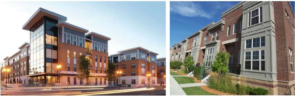
Exhibit 25 – Examples of Acceptable Architectural Styles
(b) Buildings shall be designed and constructed to be LEED Silver or equivalent.
(c) Franchise architecture shall not be permitted. Franchises or national chains shall follow recommended architectural styles to create a unique building that is compatible with the traditional Indianapolis Boulevard corridor.
(2) Scale and Proportion.
(a) All building facades, including doors, windows, column spacing, and signage shall be designed to promote human scale and proportions.
(b) A single, unbroken structure mass and facade shall be avoided in new construction and, to the extent reasonably feasible, in redevelopment projects involving changes to the mass of existing structure.
(c) New buildings shall be articulated with such means as expressed structure, window bays, piers and columns, and varied building setbacks.
(d) Horizontal masses shall maintain a height-to-width ratio of 1:3 without substantial variation in massing that includes a change in height and projecting or recessed elements.
(e) Wall elevations greater than 50 feet in length shall incorporate regular interruptions in the wall plane by projections or recesses having a depth of not less than two percent of the length of the wall. Such projection or recession shall extend for at least 20 percent of the length of the wall.
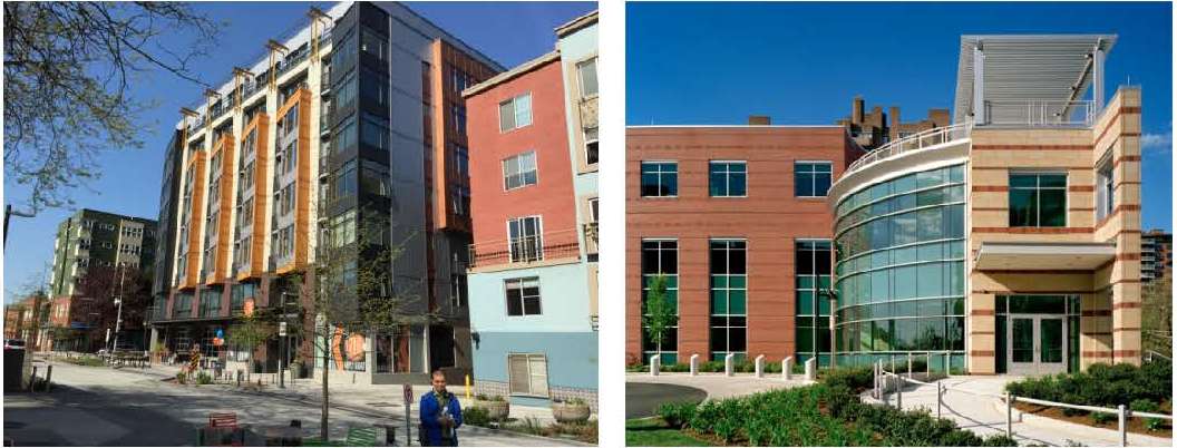
Exhibit 26 – Examples of Varied Building Articulation
(3) Building Shape. All buildings shall be designed with a minimum of six external corners, in order to eliminate the impact of the box-looking design for the buildings.
(4) Detailing. New construction and renovation shall carefully consider the style and character of the existing buildings to establish an appropriate level of detail for facades, roof lines, windows, doors, porches, entry points, railings, sidewalks, and public spaces. New buildings can be modern in design, but must reflect the same richness in detailing and character as found in the overlay district as a whole.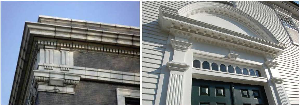
Exhibit 27 – Examples of Building Detailing
(4) Building Materials.
(a) Building exteriors shall exhibit variation in design and view of the structure. A minimum of three materials shall be used for building exteriors. The materials shall include: stone, brick, architectural precast (panels or detailing), architectural metal panels, glass, ornamental metal.
(b) Large expanses of glass are not permitted, except for the ground floor, where the minimum glass area shall be 75 percent of the facade area for all nonresidential uses.
(c) The building may not be constructed entirely of a metal and glass curtain wall. Concrete block, or split block masonry units, are not permitted as an exterior finish material on any side of the structures.
(5) Roofs.
(a) The roof form shall be designed to express the building and to promote the overall scale and character of the district.
(b) The roof form shall have a recognizable “top” and vary with the expression of parapets, gables, overhanging eaves, chimneys, brackets and cornices. Parapets shall be embellished with brick detailing and stepped or sloped to achieve a visually interesting yet harmonious sequence along the building facade.
(c) Sloped roofs shall not extend more than 100 feet without a change in roof plane, or gable or dormer.
(d) Rooftop gardens and landscaping shall be encouraged to reduce storm water runoff and reduce the heat island effect in Highland. Buildings with approved landscaping covering a minimum of 85 percent of the total roof area shall be allowed to increase their total lot coverage by up to five percent.
(6) Windows.
(a) Window placement shall be composed within a facade to create a balanced and well-proportioned facade that provides visual interest along all public rights-of-way.
(b) Window placement shall be designed to foster window shopping and promote commercial uses of the building. Ground floor buildings with office or commercial uses shall have a minimum of 75 percent glass openings.
(c) On upper floors, the windows shall be vertically oriented. Arched tops, columns framing the windows, and decorative lintels are encouraged. A minimum of 30 percent transparency in the upper floor facade shall be required.
(d) The use of curtain glass walls, opaque glass, or reflective glass in windows is prohibited.
(7) Entryways.
(a) Buildings shall have a primary entrance door facing a public sidewalk.
(b) On corner lots, the primary entrance of the building shall be located on Indianapolis Boulevard. Secondary public entrances shall be provided on the crossing side street or at the rear of the building.
(c) Building entrances may include doors to individual shops or businesses, lobby entrances, entrances to pedestrian-oriented plazas, or courtyard entrances to a cluster of shops or businesses.
(d) Creative entry treatments such as canopies, awnings, cornice treatments, or atriums shall be incorporated in the building design to the extent practical.
(e) The rear elevation of the building, facing associated parking or rear yard, shall be treated as a second front with glazed facade and signage similar to the building front to the extent practical.
(8) Site Design and Building Placement.
(a) All buildings shall be aligned along the edges of a lot towards Indianapolis Boulevard or crossing streets. Articulation of the facade and setback to create front yard public space is permitted.
(b) Where uses include opportunities for outdoor gathering on the public sidewalk (cafes, restaurants, dining establishments, etc.), there shall be a minimum of five feet of continuous and linear clearance for safe passage by pedestrians. (See Exhibit 21.)
(c) Development sites and building placement for retail and mixed uses shall establish or enhance the traditional architecture by incorporation of at least one of the following elements for every 25 feet of frontage:
1. Pedestrian plaza with seating areas and outdoor features such as planters.
2. Water feature.
3. Clock towers, monuments, or other similar features.
4. Public art.
5. Other deliberately shaped area or focal feature that enhances or create public spaces.
(d) Any such areas shall have direct access to the public sidewalk and such features shall not be constructed of materials that are inferior to the principal materials of the structure and landscaping.
(e) Where appropriate and practical, a maximum of one pedestrian plaza, parklet, or paseo per block shall be required between buildings for the provision of public connections between buildings, access to parking, open space and streets. The width of such space shall be a minimum of 15 feet, but not to exceed 25 feet. Such space may be developed on two adjoining lots if necessary to achieve the proper size and location.
(9) Open Space.
(a) All new construction, redevelopment, or other lot improvements regardless of the size of the lot shall provide for 15 percent open space on the lot, except as provided herein. The hardscape area or required green space in the underlying zoning district may be counted towards the open space requirements.
(b) An open space plan shall be submitted along with the development plan in accordance with the appropriate requirements of this title. Such plan can be combined with the landscape plan or the site plan, if practical or required.
(c) Areas dedicated as open space shall be a minimum of 15 feet wide in their smallest dimension.
(d) Areas dedicated as open space shall be free of all structures and buildings except for structures directly related to the purpose of the open space such as seating areas, plazas, sculptures, or public art.
(e) Bodies of water may be counted at a rate of 50 percent as open space, provided they are accessible and designed as natural or built spaces with ample landscaping which provide recreational or socialization opportunities to the public. Unimproved storm water detention or retention ponds shall not be counted as open space.
(f) Ownership and Maintenance of Open Space. Unless otherwise agreed to by the town, the maintenance responsibility and cost of dedicated land as open space shall be solely borne by the property owner.
(G) Landscaping. Landscaping treatments shall be used to enhance the pedestrian experience, complement architectural features and/or screen unattractive elements such as utility features. Use of flower boxes, planters, and hanging flower baskets is encouraged. In addition to the applicable requirements of Chapter 18.75 HMC, the following provisions shall apply:
(1) Streetscape.
(a) When making improvements to public or private property, including the addition of benches, trash receptacles, fencing, or bike racks, owners shall match the town’s approved standards for these elements.
(b) The streetscape shall be uniform in design and support the architectural style so that it acts to provide continuity throughout the corridor.
(c) Where a parkway area is paved, it shall follow the town’s public improvement guidelines or be based on a development plan approved by the plan commission.
(d) Existing parking lots facing a public right-of-way shall be screened by an architecturally compatible masonry wall a minimum of three feet and maximum of three feet, six inches in height. The front elevation of such wall shall be landscaped with appropriate landscaping as provided in HMC 18.75.030.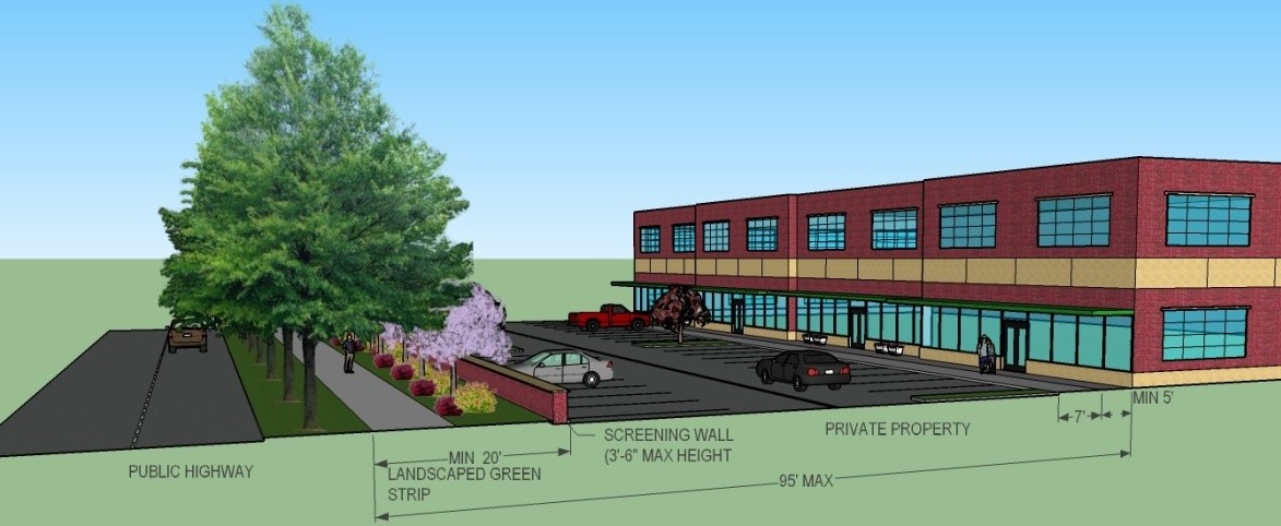
Exhibit 28 – Prototype for Parking Lot Screening
(2) Landscape Standards. In addition to the provisions of Chapter 18.75 HMC, the following landscape standards shall apply in the Indianapolis Boulevard overlay district:
(a) Green Strip. A 20-foot green strip shall be required for all property fronting the Indianapolis Boulevard corridor. The purpose of the green strip in front yards is not to totally obscure but to lower visual impact and soften the overall appearance of the corridor. The green strip shall conform to Chapter 18.75 HMC and the following:
1. Pedestrian walkways and bikeways, at a minimum width of eight feet, shall be incorporated into the design where such facilities are otherwise not provided and where it is practical.
2. If berms are incorporated into the design, such berms shall have gently rolling ridgelines. This ridgeline should not be flat and to the extent practical shall be undulating. The berm shall be a minimum of three feet and maximum of three feet, six inches in height.
3. Plant material shall be grouped in six or more plants to assure naturalistic patterns and permit view and variation. Planting in rows or along the ridge of a berm is undesirable.
4. Side slope on all berms should not exceed 3:1.
5. The ridge of all berms should have a minimum two-foot-wide rounded top (i.e., neither flat nor meeting at a peak).
(b) Foundation. Foundation plantings, as described in HMC 18.75.030(L), shall be required along the front and any side of buildings that is visible from the Indianapolis Boulevard corridor or has primary pedestrian access. Where appropriate, the establishment of green walls may be used as a substitute for foundation plantings.
Exhibit 29 – Foundation Planting
(c) Parking lots with more than 30 spaces shall be divided into separate areas by landscaped islands of at least six feet in width. A minimum of 15 percent of all surface lots shall be landscaped.
(d) Where landscaping does not meet the standards of this title, existing developments shall be required to provide such landscaping in conjunction with all renovations, expansions, and new construction whenever such work exceeds 25 percent of the value of the building(s) or property.
(e) Where landscaping does not meet the standards of this title, landscaping shall be brought into compliance whenever a minimum of 25 percent of the front yard area is renovated or improved. Any modifications to existing parking lots, including, but not limited to, parking space configuration, repaving, or lot expansion, shall be included in this requirement.
(H) Public Art.
(1) Public art that is included as part of a development plan shall be displayed in a location that is visually accessible to the public or visible from either Indianapolis Boulevard, other crossing streets, or a public plaza.
(2) Public art shall not be required; however, a credit may be awarded for such installations by the plan commission equal to the total cost of public art in lieu of landscaping but not to exceed more than 10 percent of the total landscaping cost.
(I) Parking. Parking in this overlay district shall be in accordance with provisions of Chapter 18.80 HMC, except as modified below.
(1) Required Number. The total amount of parking may be reduced based on an approved development plan. In approval of such plan, the following standards shall apply:
(a) Residential Uses. A minimum of one-half parking space shall be required per residential unit. A maximum of one space per unit may be provided if the additional parking spaces are structured.
(b) Nonresidential Uses. The number of off-street parking spaces required shall be a minimum of 50 percent to a maximum of 85 percent of the required number as provided by Chapter 18.85 HMC. The maximum may only be exceeded if the additional parking spaces are structured (in a ramp, deck, underground, or within a building).
(c) Mixed-use buildings shall use shared parking to meet the requirements of this subsection.
(d) On-street or alley parking within 600 feet of the primary entrance to the building shall be counted toward the required number of parking spaces.
(e) Parking garages and structures shall not count against the maximum building coverage standards in the overlay district; provided, that such structures are located only within the rear 85 feet of the lot.
(f) Bicycle racks shall be provided on any development at a ratio of one space for every four parking spaces or portion thereof.
(2) Access and Siting.
(a) Off-street parking shall be located to the rear of the principal building, within the rear yard area of the lot, or in an interior side yard.
(b) Off-street parking shall be located away from direct view of the public on Indianapolis Boulevard.
(c) Access to parking areas shall be provided from the rear alley, side street, service drives, or shared with adjoining parking lots to the maximum extent possible.
(d) All off-street parking areas and drives shall be paved with asphalt or concrete. Brick pavers or other decorative pavements may be used as accents in parking area design. Cast-in-place concrete curbs shall be provided.
(3) Parking structures shall be designed as an integral part of the building(s). Above grade structures shall be visually encapsulated by ground level uses to the extent possible. No freestanding garages or parking structures are permitted to face Indianapolis Boulevard unless the garage is located a minimum of 40 feet from the front property line and positioned behind or beside the primary street-oriented structure.
(4) Pedestrian and bicycle access shall be coordinated with vehicular access, front yard design and parking layout. Such pedestrian and bicycle access consideration shall include development and linkage with facilities in adjacent properties to the extent practical and the following provisions:
(a) Sidewalks shall be provided in all developments, and among all buildings and amenities within a development to the maximum extent possible.
Exhibit 30 – Example of Pedestrian Linkages among Buildings (Left) and Parking (Right)
(b) Sidewalks shall be linked with adjoining streets, pedestrian trails, and transit facilities to the extent practical.
(c) Sidewalks shall connect to contiguous lots and abutting lots, and shall be coordinated and aligned to form a continuous pedestrian walkway network that serves adjoining developments.
(J) Access to Individual Lots. Indianapolis Boulevard is a principal arterial highway. As such, access to individual lots may not be clearly defined or even existing in some cases. Further, access to some lots may be difficult due to topography of the land. In some cases, access road, service and reliever road, or shared access may be required. In order to protect the functional integrity of Indianapolis Boulevard, create ease of movement and reduce disruption, and to preserve the economic viability of the corridor, access to development sites shall be coordinated to the extent possible. To assure ease of access, the following provisions shall apply:
(1) Access points, access roads to developments and parking areas, contiguous lots, and abutting properties or larger tracts shall be coordinated to create a uniform traffic flow and formation of auxiliary service roads serving adjoining lots.
(2) The access roads and service roads shall be designed so as to direct traffic onto major arterial roads intersecting Indianapolis Boulevard and not into residential neighborhoods in accordance with the town of Highland thoroughfare plan for the corridor.
(3) The design of the access roads, points, turning lanes and other roadway improvements shall comply with the provisions of the subdivision control regulations, other local or state traffic requirements or as proposed by the thoroughfare plan.
(4) Direct access to Indianapolis Boulevard shall only be considered where physical limitation or traffic study exhibit lack of other alternatives.
(5) New access or service roads shall align with the existing or planned roads;
(6) New access points, if approved, shall be “right turn only” and, to the extent possible, such points shall be developed only from a newly constructed local traffic lane and separated from the public right-of-way.
(7) Common entrances, shared entry points, and cross easements, where possible, shall be required at the discretion of the plan commission.
(8) Traffic Study. A traffic impact study shall be required for new developments within the overlay district that are expected to generate a minimum of 50 peak trips to or from the site, or have a minimum of 75-car parking capacity. The need and decision for specific traffic impact analysis requirements for new developments shall be established by the town staff.
(K) Signage. Development signs shall conform to the provisions of Chapter 18.85 HMC. In addition, the following provisions shall apply for the Indianapolis Boulevard overlay district:
(1) Signage shall be provided as an integral element of the architectural and site design. All signs to the development shall be complementary in their use of color, shape, and material, and shall enhance the buildings and other amenities or features on the site.
(2) No principal sign shall exceed 25 percent of the ground floor wall area. No other sign on the building (e.g., window sign) shall exceed 30 square feet in size.
(3) The distance between sign and building face shall not exceed one foot.
(4) Signs shall not block or obliterate design details, windows, or cornices of the building upon which they are placed.
(5) Permanently painted window signs are encouraged, provided they are compatible with the architecture of the building and do not consume more than 33 percent of the glazing area of the window.
(6) Temporary window signage shall be limited to 33 percent of the window surface area.
(7) Multi-tenant or multi-business development shall submit a signage plan for total development. This plan shall coordinate all signage on the site in a uniform manner. Sharing of signs to identify multiple businesses is required for multi-business developments in the overlay district. For such developments, one sign shall be permitted unless specifically provided in this title.
(8) Off-premises signs shall be prohibited in the Indianapolis Boulevard overlay district.
(9) Permitted Signs. In addition to permitted signs in the underlying district, the following signs are also permitted in this overlay district.
(a) Symbolic and historic three-dimensional signs such as a projected sign, blade sign, and barber shop poles. Projected and blade signs shall not be greater than six square feet, extend more than three feet from the building face, or have a vertical clearance of less than 10 feet.
(10) Prohibited Signs.
(a) Internally illuminated signs are prohibited, except for theater or approved marquee signs.
(b) All programmable display signs or all other similar digital signs are prohibited.
(11) Wayfinding Signs. Wayfinding signs shall be provided to direct traffic to destinations within this overlay district. Wayfinding signs shall meet the following standards:
(a) Signs shall be freestanding, uniform in design, and placed on interior drives, parkways, and intersections of such drives.
(b) Signs shall be limited in size to eight feet in height and five feet in width.
(L) Lighting.
(1) Lighting in the overlay district shall serve to illuminate facades, entrances and signage, and provide an adequate level of personal safety while enhancing the aesthetic appeal of the buildings. Lighting shall be provided as an integral element of the architectural and site design.
(2) Parking lots, entry points, rear entrances, and buildings shall have uniform lighting.
(3) All fixtures, except security lighting, shall be full cutoff and shielded.
(4) Building and signage lighting shall be indirect, with the light source(s) hidden from direct pedestrian and motorist view. For exterior sign illumination, use of traditional fixtures such as shaded gooseneck lamps is encouraged.
(M) Other Requirements.
(1) Outside storage.
(a) Open storage of materials, refuse, or equipment shall not be permitted in this overlay district. Display of merchandise or goods for sale or exhibit shall not be permitted on any property.
(b) All refuse collection containers shall be enclosed on three sides and shall be architecturally compatible with the primary building.
(c) Refuse collection, recycling areas, and related uses shall be placed only in the rear side of the lot so as not to be visible from the Indianapolis Boulevard corridor. Such uses shall be fully screened on all sides in accordance with applicable screening requirements of this title.
(2) Loading areas, where required, shall be fully integrated into the building design and screened with landscaping in accordance with applicable screening requirements of this title.
(3) All utilities shall be underground.
(N) Reservation of Land for Future Improvements. It is often required to plan for extension of utilities, or provide for future access to other parcels through a proposed new development site. As such, and in order to assure an orderly development process, new development shall provide for reservation of land for future improvements, if any, in accordance with the provisions of the subdivision control ordinance, the comprehensive plan, the thoroughfare plan, or other local and state plans. [Ord. 1659 § 1, 2017].