


Chapter 17.01
GENERAL PROVISIONS
Sections:
17.01.030 Establishment of Districts.
17.01.010 Overview
A. Title. These regulations shall be referred to as the Gardner Land Development Code. References to “the Code,” “LDC,” or “these regulations” shall be considered a reference to the Gardner Land Development Code, and references to “zoning” or “subdivision” regulations or standards may be interpreted as references to specific parts of the LDC.
B. Purpose. The purpose of the Gardner Land Development Code is:
1. To implement the Comprehensive Plan for the City, and any specific plan, program or policy officially adopted by the City under the guidance of the Comprehensive Plan;
2. To protect the public health, safety and welfare;
3. To require the efficient and orderly location and design of streets in order to advance the transportation policies, development patterns and civic design features of the Comprehensive Plan;
4. To implement a system of open and civic spaces for natural, recreation, social, cultural and aesthetic needs of the community;
5. To coordinate construction of required off-site and on-site public improvements in an efficient and timely manner;
6. To enable development, promote site and building designs, and implement standards according to the plan, and to mitigate potential impacts on adjacent property owners’ rights to develop according to the plan;
7. To accomplish any other specific objectives authorized by the Kansas Statutes for implementation of development policies and comprehensive plans.
C. Authority and Jurisdiction. These regulations are created through the authority of Chapter 12, Article 7 of the Kansas Statutes. The provisions of these regulations shall apply to all structures and land in the incorporated area of Gardner, Kansas, as depicted on the official zoning map, and may apply to any other areas designated by the City through procedures and criteria authorized by Chapter 12, Article 7 of the Kansas Statutes.
D. Severability. If any court of competent jurisdiction shall adjudge any provision of these regulations to be invalid, the judgment shall not affect any other provisions of these regulations. If any court of competent jurisdiction shall adjudge the application of a provision of these regulations to be invalid when applied to a particular property or project, the judgment shall not affect the application of the provision to other property or projects with different circumstances.
E. Effective Date. The Land Development Code is effective on and after August 1, 2016. (Ord. 2518 § 2 (LDC § 1.01))
17.01.020 Interpretation
A. Rules of Construction. The following rules shall apply to the application and interpretation of these regulations, unless the context clearly indicates otherwise:
1. All words shall have the customary dictionary meaning, unless specifically defined in these regulations.
2. The present tense includes the future tense and the future tense includes the present tense.
3. The singular includes the plural and the plural includes the singular.
4. Lists of examples prefaced by “including the following,” “such as,” or other similar clauses shall not be construed as exclusive or exhaustive and shall not preclude an interpretation of these lists including other similar and nonmentioned examples.
5. “Shall” or “must” is mandatory; “should” or “may” is permissive, but recommended as a way to best meet the standard or intent of the standard.
6. A reference to an administrative official shall refer to that official or his or her official designee, and all references to specific City officials may also include any other designee of the City Administrator.
7. Any reference to other official local, state or federal government rules or regulations shall include the current versions of those regulations, provided they remain binding or are consistent with the purposes, intent, and objectives included in these regulations.
8. References to a person shall include individuals, partnerships, agencies, corporations or other legal entities.
B. Measurements. The following rules shall apply to the interpretation of measurements and dimensional standards:
1. General Calculations. When calculations result in fractions it shall be rounded up to the nearest whole number if the standard is expressed as a minimum requirement, and rounded down to the nearest whole number if the standard is expressed as maximum allowance.
2. Buildings. The following shall be used in interpreting dimensional standards for buildings:
a. Building Coverage. The percentage of the total area of the lot covered by buildings or roofed areas of principal and accessory buildings, measured along the wall at ground level, excluding the first four feet of any unenclosed roof overhangs. Building coverage may control the scale, mass or orientation of the building more than is established within the setback lines. It does not include any unroofed projections, surface parking, or uncovered patios, stoops or plazas.
b. Building Frontage. The portion of the building that establishes the relationship to the public realm or street upon which the lot fronts. When expressed as a minimum percentage, it shall be interpreted as the percent of the lot frontage at which a building line must be established, including any specified alternatives to the building line which establish a similar relationship to the public realm or street.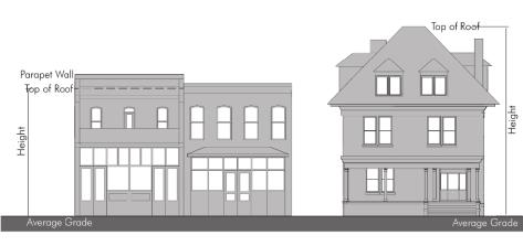
Figure 1-1 Building Height
Building height from the average grade to the top of roof. Parapets on flat roof buildings are not considered when measuring height, and are subject to limited exceptions in this Code.
c. Building Height. Building height is measured from the average grade to highest point of a roof. Average grade is determined by calculating the average of the highest and lowest elevation of predevelopment grade along the front building line parallel to the street. Where significant development is proposed in association with a grading plan, post development grades may be used subject to that plan. Building heights expressed in both dimension and stories shall use the additional story limits to impact the scale, form, and mass of the building within the permitted overall height.
d. Building Setbacks. The minimum required distance between any lot line and the building. When front building setbacks are expressed as a range (i.e., 10 feet to 25 feet), it shall be interpreted as a “build to” range, within which distance the front building line of the principal structure shall be established.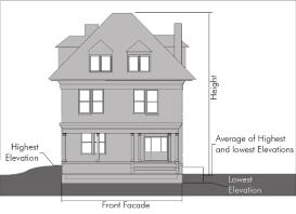
Figure 1-2 Building Height and Grade
The average grade at the front building line is the point from which height is measured; grades from front to rear do not affect permitted building height.
e. Story. The part of a building included between the surface of one floor and the surface of the floor next above, or if there is no floor above, that part of the building which is above the surface of a floor and the ceiling next above. Story heights shall be:
(1) Eight feet to 12 feet, generally;
(2) The first story for residential buildings should be nine feet to 14 feet;
(3) The first story in nonresidential buildings should be 12 feet to 20 feet;
(4) Any story that has less than four feet of its height exposed above finished grade on the front elevation, or which has more than 50 percent of its perimeter wall area measured from the finished floor elevation surrounded by finished grade, shall not count as a story for the purpose of measuring building height.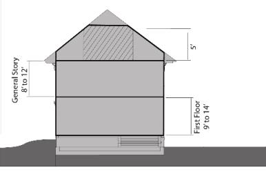
Figure 1-3 Story Heights
Where story and half-story limits are applicable on specific building types, they may further reduce the mass and scale within the permitted height.
f. Story, Half. The space under a sloping roof that has a line of intersection of the roof and wall face not more than two feet above the floor level and in which the possible floor area with head room of five feet or less is at least 40 percent of the total floor area of the story directly beneath.
3. Lots. The following shall be used in interpreting dimensional standards for lots:
a. Lot Area. The minimum required area of a horizontal plane bounded by the vertical planes through front, rear and side lot lines, or when expressed as a range it shall be interpreted as a minimum and a maximum.
b. Lot Depth. The horizontal distance between the front and rear lot lines measured at right angles to the front right-of-way lines. Where the front and rear lines are not approximately parallel, the lot depth shall be the average when measured from at least three different points along the front lot line, including the two corners at the front lot line.
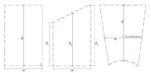
Figure 1-4 Measuring Lots
The figure illustrates the measurement of lot dimensions.
c. Lot Frontage. The portion of the lot that establishes the relationship between the building and other site elements and the public realm or street upon which the lot fronts. When expressed as a linear dimension, the horizontal distance between side lot lines, measured at the front lot line. Where the front lot line abuts a curved right-of-way, the lot frontage requirement may be applied at the front building line for purposes of regulating the dimensions of lots. When expressed as a percentage, the maximum percentage of that frontage width applied to the entire depth of the frontage area.
d. Lot Width. The horizontal distance between the side lot lines, typically measured at the front lot line, but for irregular lots it may be measured at the front building line.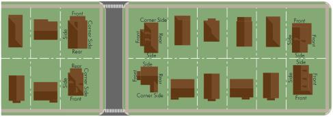
Figure 1-5 Corner Lots
Homes located at the corner are allowed to address either or both abutting streets for the front setback. This grants the residences options when addressing the street.
e. Corner Lots. When applying building, lot and frontage standards to corner lots, lots can be arranged in one of three patterns based on the context of the block and abutting lots:
(1) Standard Corner. The building orients to the front of all other buildings fronting on the same street, and an expanded street-side setback may apply. Side and rear setbacks apply to the remaining sides.
(2) Reverse Corner. The building orients to the end-grain of the block, and the front setback and frontage design applies to that side, and the street-side setback can be the greater of (A) the stated street-side setback for that building type or (B) 10 feet in front of the forward-most point of the front building line of the abutting lot. Side and rear setbacks apply to the remaining sides.
(3) Corner Orientation. The building orients to both streets, with the front setback and frontage design applying on both street sides. The two remaining sides are treated as side setbacks and there is no rear setback.
4. Signs. The following shall be used in interpreting dimensional standards for signs:
a. General Area Calculation. Signs mounted on or displayed as a standard geometrical shape shall be measured by the standard mathematical formula for that shape. Signs mounted on or displayed as an irregular shape shall be measured by the smallest area of up to two standard geometrical shapes that can encompass the entire sign mounting.
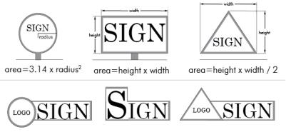
Figure 1-6 General Area Calculations
Typical method for measuring typical sign shapes; irregular signs are measured within the smallest area of up to two geometric shapes that contain the entire sign.
b. Detached Signs. The area of the sign shall be computed by the entire area of the face of the structure, cabinet or module enclosed by the border of the frame.
c. Wall, Window or Other Building-Mounted Signs. Any building-mounted sign mounted on a background shall be measured by the area of the background. If mounted directly on the wall, the area shall be computed by means of the smallest single and continuous perimeter of up to two standard geometric shapes that enclose the outer limits of the writing, emblem or other display. Gaps in writing, emblems or other display which are greater than two times the height of the sign area, when using the same single continuous perimeter above, may be subtracted from the calculation of the sign area but shall be interpreted as two signs. The area of the wall or window area for the purposes of determining an allowed percentage shall be the total surface of the wall or window visible in an elevation view.
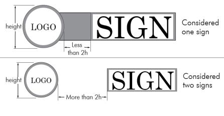
Figure 1-7 Gaps between Signs
Larger gaps may be subtracted from sign area calculations, but is considered two separate signs.
d. Decorative Elements. Embellishments such as pole covers, framing, decorative roofing and support structures shall not be included in the area of the measurement if they contain no writing, emblem or other display.
e. Double-Faced Signs. Where the sign faces of a double-faced sign are no more than three feet apart at any location, only one face will be measured in computing sign area. If the two faces of a double-faced sign are of unequal area, the area of the sign will be the area of the larger face. In all other cases, the areas of all faces of a multi-faced sign or the surface area of objects will be added together to compute the area of the sign.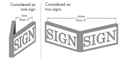
Figure 1-8 Double-Faced Signs
When opposing faces are within three feet, a double-faced sign is considered one sign and the area of one-face is the size; when separated by more than three feet, each profile is considered a sign and counts to the total sign area.
f. Height. Sign height is measured from the existing lowest grade directly below the sign to the highest point on the sign or sign structure.
g. Clearance. Sign clearance is measured from the highest point of the ground directly below the sign to the lowest point on the sign structure enclosing the sign face.
C. Computation of Time. The following rules apply to any computation of time, unless a specific section of these regulations indicates otherwise:
1. The day of the act that commences a time period shall not be counted.
2. The last day of the time period shall be included, unless it is a Saturday, Sunday or legal City holiday, in which case the next working day shall end the time period.
3. Whenever any time period is expressed for a formal submittal to the City, the time period shall end at 4:00 p.m. on the last day of that time period.
4. Any time period expressed in years shall include a full calendar year from the act that commences the time period.
D. Conflicts. In case of a conflict between these regulations and any other adopted regulation of the City, the more restrictive standard shall apply. In making a determination of which standard is more restrictive the official may consider which is more specific, which is more consistent with the comprehensive plan, which is more consistent with the purposes, intent and objectives of these regulations, and which best promotes the public health, safety and welfare.
E. Intent Statements, Graphics and Commentary. Intent statements, graphics and commentary such as captions to graphics or notes in tables are an aid to interpretation of the text. In the event of any conflict or ambiguity between the intent statements, graphics or commentary and a specific standard, the specific standard shall control.
F. Interpretation of Zoning Map. Where uncertainty exists with respect to any boundary on the zoning district map, the following rules shall apply:
1. Where boundaries are indicated to approximately follow streets or other rights-of-way or water bodies, the centerlines or extension of these centerlines shall be the boundaries.
2. Where the district boundaries are indicated as approximately following property lines, the platted or other official legal lines of that property shall be the boundaries, unless the property boundaries on the map have been substantially altered.
3. Where the district boundaries split any platted lots, the lot shall be interpreted in the district designated to the majority of the lot.
4. Where the district boundaries split any unplatted property, any future platting of property may generally follow the zoning boundary and then each resulting property may assume the zoning applicable to the majority of the resulting lot, or where any resulting lots have significant discrepancies with zoning boundaries, rezoning may be required.
G. Interpretation of Plans. Where these regulations refer to the Comprehensive Plan or any maps associated with these plans, they shall be interpreted as follows:
1. The maps are a general framework and guide for decision-making, and do not predetermine any specific use of land or buildings, or any application of a specific zoning category.
2. Any zoning decision consistent with the land use component of the plan, including any land use, development or zoning map, shall be presumed reasonable. Other zoning decisions may also be reasonable if justified upon applications of the specific goals and policies of the plan to a particular context, or, if based on analysis of that context, assumptions in the plan have changed or are different from anticipated.
H. Resources, Guides and Industry Standards. Resources, guides and industry standards that are recognized as reputable authority in the planning, development and urban design professions may be used to supplement interpretation of this Code. They shall be subject to the approval of the Director upon a determination that the content is consistent with the policies of the Comprehensive Plan and the purposes, intent, and design objectives of these regulations. Any resource, guide, or industry standard approved by the Director shall be listed in Appendix A and at least one copy shall be kept on file with the Community Development Department. Use of these guides shall be consistent with the purposes, intent and design objectives expressed in these regulations, and shall not be used to otherwise modify, contradict or in any way conflict with any specific standard in these regulations. (Ord. 2673 § 11; Ord. 2518 § 2 (LDC § 1.02))
17.01.030 Establishment of Districts
A. List of Districts. The zoning districts established in GMC 17.05.010 are established to implement the purposes of these regulations.
B. Zoning Map Incorporation. The boundaries of the districts listed in GMC 17.05.010 are shown on the zoning district map of the City of Gardner, Kansas, which is filed in the office of the City Clerk. The map, with all notations, references and official ordinances amending the map, is incorporated into these regulations.
C. Annexed Land.
1. Zoning Classification at the Time of Annexation. Upon annexation, the City shall initiate a petition to rezone an annexed property to the zoning district most similar to the zoning classification in effect under the prior jurisdiction. Alternatively, an annexed property owner may request that the aforementioned City-initiated rezoning petition be deferred and may initiate an application to rezone an annexed property to an appropriate district(s) associated with a development plan/plat for the property.
2. Zoning Classification and Regulations After Annexation.
a. Any owner of land within the area annexed may apply for rezoning under the laws and procedures of the City, and as granted by KSA 12-756 and 12-757, after the effective date of annexation.
b. If property annexed before the effective date of this title is rezoned to a City zoning district, all zoning requirements and regulations of the City take effect, and the regulations of the prior zoning jurisdiction terminate, within the annexed area.
3. Enforcement. The City may secure civil remedies for violations of prior zoning jurisdiction regulations to the same extent that it may secure civil remedies for violations of this section pursuant to GMC 17.01.050. (Ord. 2695 § 1; Ord. 2518 § 2 (LDC § 1.03))
17.01.040 Administration
A. Staff. The following City staff positions are responsible for administering specific aspects of this Code:
1. Director of Community Development. The Director of Community Development (Director) is the principal interpretation and enforcement officer under these regulations, and may consult with any other department or relevant outside agencies in order to coordinate their plans, policies and programs that impact the Comprehensive Plan. The Director shall make all final interpretation decisions and any final administrative decisions referred to the Director under the procedures and standards of these regulations.
2. City Engineer. The City Engineer shall be the person serving in the position of City Engineer and is responsible for reviewing the engineering design, construction, operation and maintenance of all public improvements specified under these regulations. The City Engineer shall advise the Director on any technical specifications and engineering designs that impact implementation of the Comprehensive Plan, and may make any final administrative decisions referred to the City Engineer under the procedures and standards of these regulations.
B. Planning Commission. The Planning Commission is the appointed body of the City responsible for all long-range and comprehensive planning, as well as review, recommendations and decisions on implementation of the Comprehensive Plan. In addition to other general planning authority by statute, local ordinance, or bylaws, the Planning Commission shall have the specific review responsibilities and final administrative decisions referred to the Planning Commission under the procedures and standards of these regulations.
C. Governing Body. The Governing Body is the elected body of the City responsible for all legislative decisions that affect implementation of the Comprehensive Plan. In addition to other general authority authorized by law, the Governing Body shall have the appeal authority and final decision authority referred to the Governing Body under the procedures and standards of these regulations.
D. Board of Zoning Appeals. The Board of Zoning Appeals of the City of Gardner, Kansas, is hereby continued in accordance with the provisions of K.S.A. 12-759.
1. Membership. The Board of Zoning Appeals shall be composed of the members of the Planning Commission of the City.
2. Officers. The members of the Board shall elect from their membership a Chairman and shall appoint a Secretary, each of whom shall serve for a term of one year from the date of their election or appointment by the Board.
3. Rules of Procedure. The Board shall adopt rules of procedure in accordance with the authority conferred by K.S.A. 12-759.
4. Meetings. While the members shall serve both the Planning Commission of the City and the Board of Zoning Appeals, they shall hold a separate meeting, which may be of a time of their choosing, as the Board of Zoning Appeals. Meetings of the Board shall be held at the call of the Chairman, and at such other times as the Board may determine. The Secretary of the Board shall keep minutes of its proceedings and official actions, and shall keep records of its examinations and findings, and shall file the same in the office of the Board or such other public place within the City where public records are filed. The presence of four members of the Board shall constitute a quorum for transacting business and a majority vote of the Board with no less than four concurring votes shall be necessary to effect a ruling of the Board.
5. Powers and Duties. The Board shall administer the following matters under the procedures and standards of these regulations:
a. Appeals of administrative decisions;
b. Variances; and
c. Any other exceptions or relief specifically referred to it under the procedures and standards of these regulations. (Ord. 2673 § 12; Ord. 2617 § 1; Ord. 2518 § 2 (LDC § 1.04))
17.01.050 Enforcement
A. Violations. It shall be unlawful for any building, structure, site element or use of land to be constructed, altered, maintained, or otherwise initiated in violation of these regulations.
B. Enforcement. The City may investigate and initiate proper actions or proceedings to prevent or terminate any activity or condition that is in violation of these regulations, including revoke or withhold any permits, prevent the sale or lease of property, correct or abate the nuisance, withhold any public improvements, or penalize and initiate legal proceedings to prevent the continuance of unlawful actions or conditions.
C. Penalty. Any person violating any of the provisions of this Code shall be guilty of a misdemeanor, each day constituting a separate offense. Each offense shall be punished by a fine established by the Governing Body by resolution. The City of Gardner, Kansas, shall further have the right to maintain suits or actions in any court of competent jurisdiction for the purposes of enforcing these regulations and to abate any potential nuisance. In addition to all other remedies provided by law, injunctions, mandamus or other appropriate actions may be instituted to prevent violations including revocation of any permit authorized under this Code. (Ord. 2518 § 2 (LDC § 1.05))
17.01.060 Nonconformances
A. Intent. It is the general policy of the City to allow uses, buildings and lots that were created legally and in conformance with then-applicable requirements, but that do not conform to the current applicable requirements of these regulations, to continue. However, it is also the policy of the City to bring such uses, buildings and lots into conformance with current regulations as is reasonably practical. The intent of this section is to balance the interests of property owners in past investments, discourage investment that expands or reinforces nonconforming situations, and promote investment consistent with the Comprehensive Plan and these regulations.
B. Nonconforming Uses. Uses that were legally initiated prior to the adoption or amendment of this Code, but which could not be continued under the current terms of this Code, may continue to exist subject to the following:
1. The use may not be expanded beyond any specific area of the site or lot, but may be expanded within any existing building.
2. Any activity that triggers specific site design standards shall require full compliance of the site design standards in order for the nonconforming use to be allowed to expand.
3. A use that is discontinued for six months or more shall lose its nonconforming status, and all future use of the site or building shall comply with these regulations.
4. Any change of use shall be to a conforming use.
C. Nonconforming Structures. Structures that were legally constructed prior to the adoption or amendment of this Code, but which could not be constructed under the current terms of this Code may continue to exist subject to the following:
1. Rehabilitation or expansion of the structure that increases the degree of nonconformity is prohibited. Other rehabilitation or expansions may occur; provided, that they comply with all other requirements of this Code, are not detrimental to the purposes, intent and objectives of the standards, and do not negatively impact development in conformance with this Code on adjacent property.
2. If destroyed by fire, natural disaster, accident or public enemy by less than 50 percent of its appraised value, the structure may be restored to its original condition if the restoration is started within six months.
3. If the structure is determined obsolete or substandard by virtue of any applicable code beyond this title, and the cost of improvement or restoration is 50 percent or more of the appraised value of the structure, then the right to maintain the nonconformance shall terminate.
D. Nonconforming Site Conditions. Any site condition associated with a conforming use or structure (such as parking, landscape, open space or other nonbuilding site characteristic) in existence prior to these regulations but which are not compliant with the standards of these regulations may continue to exist subject to the following:
1. Any change of use or expansion of use shall require compliance with the new standards up to the proportion that is required by the change.
2. Any site development activity on a portion of a site shall require compliance with the new standards up to that proportion that is subject to the development activity.
3. Where any investment is greater than 50 percent of the appraised value of the site, or can reasonably be interpreted as impacting more than 50 percent of any one component of the site, the site or that component shall be brought into full compliance with these standards.
4. To promote infill development or adaptive reuse of existing sites and buildings, administrative adjustment procedures in Chapter 17.03 GMC may account for nonconforming site conditions.
E. Nonconformances Created by Annexation. All nonconformances created as a result of the application of the corresponding zoning district at the time of annexation (per GMC 17.01.030(C)(1)) shall be allowed to remain in place. Improvements to property, in support of the use of the property at the time of annexation, will be reviewed on a case-by-case basis and may allow for:
1. An expansion of the nonconforming structure(s) or site condition(s) to which the improvement/investment is not greater than 50 percent of the appraised value of the property or applicable structure.
2. An expansion of the nonconforming structure(s) or site condition(s) that is in closer conformance than the condition that existed at the time of annexation, with the applicable zoning district requirements but not necessarily full compliance, to which the improvement/investment is not greater than 50 percent of the appraised value of the property or applicable structure.
Such case-by-case determinations shall be made by the Director with appeals of such determinations going to the Planning Commission.
F. Nonconforming Lots. Any lots platted legally prior to the adoption or amendment of this Code, but which could not be platted under the current requirements of this Code, may continue to exist, provided they comply with all other applicable standards. Any difficulties meeting these standards caused by the nonconformance of the lot may be used as criteria in granting any discretionary relief to these standards. A nonconforming lot shall not be used, conveyed, transferred, subdivided, nor have its boundaries altered in any manner, except for government purpose, that would compound or further increase the nonconforming characteristics of the lot. Such nonconforming lots may be combined, per the applicable plat procedure, provided this merger does not increase the degree of any nonconformity, and any such newly combined lot that does not meet current lot standards will continue to be a legal nonconforming lot even though it was not platted legally prior to the adoption of this Code.
G. Signs. Existing signs which were lawful at the time, but made nonconforming by adoption or amendment to this Code, shall be legal, provided they are maintained in good condition. Nothing in this Code shall prohibit the ordinary maintenance repair of a nonconforming sign or replacement of a broken part of a nonconforming sign. Replacement of copy, content or message may be considered ordinary maintenance.
1. A legal nonconforming sign shall not be:
a. Changed to another type or shape of nonconforming sign;
b. Physically changed to expand or extend the size of the sign or to replace significant materials of the sign or sign structure;
c. Continued after more than six months of abandonment or vacancy of the property;
d. Reestablished after any removal of the sign that is not part of ordinary maintenance; or
e. Continued if a substantial part of the property or building is redeveloped, including more than 25 percent of the property or building by area or by value.
2. Nonconforming signs that are destroyed or damaged by 50 percent or more of their value shall not be rebuilt or repaired except in conformance with this Code.
H. Burden of Proof. The burden shall be on the applicant to establish entitlement to continuation of nonconforming situations or completion of nonconforming projects. (Ord. 2695 §§ 2 – 5; Ord. 2587 § 1; Ord. 2518 § 2 (LDC § 1.06))