


Chapter 3
General Definitions
7.301 General Definitions.
Adjacent. Lots are adjacent when at least one boundary line of one lot touches a boundary line or lines of another lot. Exception: when the only touching boundary lines are located within a road easement or right-of-way.
Agriculture. The art or science of cultivating the ground, the production of crops or livestock on a farm, excluding commercial greenhouses, the sale of nursery stock, riding stables, mink, fox and similar so-called fur farms, hog or poultry farms using garbage as a feed, processing of milk other than milk produced on the farm on which the processing is located.
Alley. A public or legally established private thoroughfare, other than a street, which affords a secondary means of vehicular access to abutting property.
Alterations. Any change, addition or modification in construction or type of occupancy; any change in the structural members of a building, such as walls, partitions, columns, beams, girders; or any change which may be referred to herein as “altered” or “reconstructed.”
Awning. A retractable or fixed shelter projecting from and supported by the exterior wall of a building constructed of non-rigid materials on a supporting framework.
A Street. See STREET TYPE.
Basement. See: STORY.
Block. The property abutting one side of a street and lying between the two nearest intersecting streets; or between one intersecting street and a railroad right-of-way, unsubdivided acreage, river or live stream or between any of the foregoing and any other barrier to the continuity of development.
Board of Appeals. See: ZONING BOARD OF APPEALS.
Buildable Area. The buildable area of a lot is the space remaining after compliance with the minimum required setbacks of this Ordinance.
Building. A structure having a roof supported by columns or walls for the housing or enclosure of persons, animals or property. This shall include tents, awnings, or vehicles situated on private property and used for purposes of a building.
Building Height. The vertical distance measured from the bottom of the floor joists or floor slab of the first story to the highest point of the roof for flat roofs; and to the deck line of mansard roofs; and to the average height between eaves and ridges for gable, hip, and gambrel roofs. Where buildings have multiple or conflicting roof styles, the most restrictive method of measurement applies. See Figure 12. Building Height.
Building Official. The primary administrative officer of this Zoning Ordinance or his or her designee, established in conformity to the City Charter shall be known throughout this ordinance as the building official.
B Street. See STREET TYPE.
Canopy. A permanent roof-like shelter that extends from part or all of a building face and is constructed of non-rigid material, except for the supporting framework.
Court. A yard, other than a required open space, on the same lot with a building or group of buildings, and which is bounded on two or more sides by such building or buildings.
C Street. See STREET TYPE.
District. This term is synonymous with the term “zone” or “zone district” a portion of the City of Pontiac within which, on a uniform basis, certain uses of land and buildings are permitted and within which certain regulations and requirements apply under the provisions of this Ordinance.
Disturb Area means an area where soils are exposed or disturbed by development, both existing and proposed. The disturbance area includes staging and storage areas, structures, and areas needed for vehicle access and maneuvering. Agricultural and pasture land are not considered part of the disturbance area.
For utility lines, trenches, or other similar linear work, the disturbance area includes staging and storage areas, the linear feature, and the areas on each side of the linear feature impacted by the construction. Where necessary for safety in deep trenches, the disturbance area may be made wide enough to allow for bending and shoring of the trench.
Erect. Build, construct, attach, hang, place, suspend, affix, move upon, or any physical operations on the premises required for the building. Excavation, fill, drainage, and the like, shall be considered a part of erection.
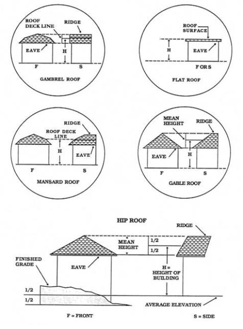
Figure 12. Building Height
Essential Services. The phrase “essential services” means the erection, construction, alteration, or maintenance by a public utility of underground, surface, or overhead gas, electrical, steam, fuel or water transmission or distribution systems, collection, communication, supply or disposal systems including towers, poles, wires, mains, drains, sewers, pipes, conduits, cables, fire alarm boxes, police call boxes, traffic signals, hydrants, and other similar equipment and accessories in connection therewith reasonably necessary for the furnishing of adequate service by such public utilities for the public health, safety, or general welfare; such essential services, however, do not include buildings, electric substations, gas regulator buildings, pole or storage yards.
Excavating. Excavating shall be the removal of sand, stone, gravel or fill dirt below the average grade of the surrounding land and/or road grade, whichever shall be the highest.
Facade. That portion of any exposed exterior elevation of a building extending from grade to top of the parapet, wall or eaves and the entire width of the exposed building elevation.
Family.
A. An individual or group of two or more persons related by blood, marriage or adoption, together with foster children of the principal occupants, with not more than two additional unrelated persons, who are domiciled together as a single, domestic, housekeeping unit in a dwelling unit; or
B. A collective number of individuals domiciled together in one dwelling unit whose relationship is of a continuing nontransient domestic character and who are cooking and living as a single nonprofit housekeeping unit. This definition does not include any society, club, fraternity, sorority, association, lodge, coterie, organization, or group of students or other individuals whose domestic relationship is of a transitory or seasonal nature or for an anticipated limited duration of a school term or other similar determinable period.
Filling. The depositing or dumping of any matter onto, or into, the ground, except common household gardening.
Floor Area.
A. Gross Floor Area. The sum of the gross horizontal areas of the several floors of the building measured from the exterior faces of the exterior walls or from the centerline of walls separating two buildings. The “floor area” of a building, which is what this normally is referred to as, includes the basement floor area when more than one-half (1/2) of the basement height is above the established curb level or finished lot grade, whichever is higher. Any space devoted to off-street parking or loading shall not be included in floor area. Areas of basements, utility rooms, breezeways, unfinished attics, porches (enclosed or unenclosed) or attached garages are not included. See Figure 13. Floor Area Terms.
B. Usable Floor Area. That portion of the floor area, measured from the interior face of the exterior walls, used for or intended to be used for services to the public or to customers, patrons, clients or patients, including areas occupied by fixtures or equipment used for the display or sale of goods or merchandise, but not including areas used or intended to be used for the storage of merchandise, utility or mechanical equipment rooms, sanitary facilities, or service hallways or corridors. In the case of a half story, the usable floor area shall be considered to be only that portion having a clear height above it of four (4) feet or more. See Figure 13. Floor Area Terms.
Garbage. Garbage shall mean putrescible, animal, fish, fowl, fruit and vegetable wastes resulting from the storage, handling, preparation, cooking, or consumption thereof.
Grade. For the purposes of determining building height:
A. For buildings adjoining one street only, it is the elevation of the sidewalk directly opposite the center of that wall which adjoins the street; in such case where the average elevation of the finished ground surface adjacent to the exterior walls of the building is lower than the elevation of the sidewalk grade, or where there is no sidewalk grade, or where there is no sidewalks, the grade shall be the average elevation of the ground on the lowest side adjacent to the exterior walls of the building.
B. For buildings adjoining more than one street, it is the elevation of the sidewalk directly opposite the center of the wall adjoining the street having the lowest sidewalk elevation.
C. For buildings having no wall adjoining the street, it is the average level of the finished ground surface adjacent to the exterior walls of the building.
D. All walls which are approximately parallel to and not more than 25 feet from a front lot line shall be considered as adjoining the street. In alleys, the surface of the paving shall be considered to be the sidewalk elevation. Where the elevation of the sidewalk or alley paving has not been established, the city engineer’s office shall determine such elevation for the purpose of this ordinance.
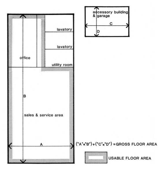
Figure 13. Floor Area Terms
Home Occupation. An occupation or profession customarily carried on by the occupant of a dwelling unit at the dwelling unit as a secondary use which is clearly subservient to the use of the dwelling for residential purposes. Home occupation includes a bed and breakfast operation.
Industrial District. An M-1, M-2, or IP-1 zoning district.
Junk Yard. The term “junk yard” includes automobile wrecking yards and includes any area of more than 200 square feet for the storage, keeping, or abandonment of junk, including scrap metals or other scrap materials, or for the dismantling, demolition, or abandonment of automobile or other vehicles or machinery or parts thereof, but does not include uses established entirely within enclosed buildings.
Junk. For the purpose of this ordinance, “junk” in addition to including garbage and rubbish shall mean any motor vehicles, machinery, appliances, product, merchandise with parts missing, or scrap metals or other scrap materials that are damaged, deteriorated, or are in a condition which renders them incapable of performing the function for which they were intended.
Lake, private. Any body of water, other than a public lake, which is owned by one person, group of persons, partnership or corporation for their use only.
Lake, public. Any body of water, which is not private, and which is accessible to the public via public owned lands, waters, or highways contiguous thereto, or via the bed of a navigable stream and which may be used for navigation, fishing, hunting or other lawful purpose, and reasonably capable of supporting a beneficial public interest.
Lot. A lot of record or a parcel of land including, in addition to the land required to meet the regulations of this ordinance, all of the land area shown in a request for a zoning compliance permit, used or intended to be used as the site for a principal and accessory building or use.
Lot Area. The total horizontal area within the lot lines of a lot. For lots fronting or adjacent to private streets, lot area shall be interpreted to mean that area within lot lines separating the lot from the private street, and not the centerline of such private street.
Lot, Corner A lot where the interior angle of two adjacent sides at the intersection of the two streets is less than 135 degrees. A lot abutting upon a curved street shall be considered a corner lot for the purposes of this ordinance if the arc is a radius of less than 150 feet and the tangents to the curve, at the two points where the lot lines meet the curve or the straight street line extended form an interior angle of less than 135 degrees. See Figure 14. Lot Terms.
Lot Coverage. The part or percent of the lot occupied by buildings or structure, including accessory building or structures.
Lot Depth. The mean horizontal distance measured form the front street right-of-way line to the rear lot line.
Lot, Double Frontage. Any interior lot having frontage on two more or less parallel streets as distinguished from a corner lot. In the case of a row of double frontage lots, all sides of such lots adjacent to streets shall be considered frontage, and front yards shall be provided as required. See Figure 14. Lot Terms.
Lot, Interior. Any lot other than a corner lot. See Figure 14. Lot Terms.
Lot Line. Any line dividing one lot from another lot, or from a street right-of-way or from any public place:
A. Front Lot Line. In the case of an interior lot, the line separating such lot from the street. In the case of a corner or through lot, the line separating such lot from that street which is designated as the front street in the request for zoning compliance permit.
B. Rear Lot Line. The lot boundary opposite the most distant from the front lot line. In the case of a pointed or irregular lot, it shall be an imaginary line parallel to the farthest from the front lot line, not less than ten feet long and wholly within the lot.
C. Side Lot Line. A side lot line is any lot not a front lot line or a rear lot line. A side lot line separating a lot from a side street is an side street lot line. A side lot line separating a lot from another lot or lots is an interior side lot line.
D. Side Street Lot Line. In the case of a corner lot, the side street lot line is the line separating such lot from the street which is not designated as the front street in the plat or in the application for a building permit or zoning occupancy permit.
Lot of Record. A parcel of land, which is set forth as a separate parcel on any plat on record with the county register of deeds or any parcel which has been separated therefrom in accordance with the provisions of the Plat Act, and which exists as described.
Lot, Through. A double-frontage lot having a street for both front and rear lot lines. See Figure 14. Lot Terms.
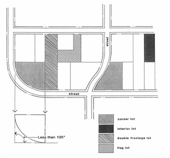
Figure 14. Lot Terms
Lot Width. The length of a straight line drawn between the points where the front required setback intersects the side lot lines.
Marihuana Business. Are the following adult-use marihuana establishments, whether operated for profit or not for profit: (a) grower, (b) safety compliance facility, (c) processor, (d) retailer, (e) social equity retailer, (f) secure transporter, (g) Class A microbusiness, (h) designated consumption establishment, (i) marihuana event organizer or (j) temporary marihuana event.
Master Plan. A comprehensive plan including graphic and written proposals indicating the general location for streets, parks, schools, public buildings and all physical development of the City and includes any unit or part of such plan, and any amendment to such plan or parts thereof.
Medical Marihuana Facility. A location at which a grower, processor, provisioning center, secure transporter, or safety compliance facility is licensed to operate under the MMFLA.
Mixed Use District. Any C-O, C-1, C-2, C-3, C-4, C-C, G-O-T, MUD, TC, or SP zoning district.
MMLFA. The Medical Marihuana Facilities Licensing Act, Act No. 281 of the Public Acts of 2016, being Sections 333.27101 to 333.27801 of the Michigan Compiled Laws.
MMMA. The Michigan Medical Marihuana Act, Initiated Law 1 of 2008, being Sections 333.26421 to 333.26430 of the Michigan Compiled Laws.
MRTMA. The Michigan Regulation and Taxation of Marihuana Act, Initiated Law 1 of 2018, being Sections 333.27951 to 333.27967 of the Michigan Compiled Laws, and the administrative rules promulgated thereunder.
Nonconformities.
A. Nonconforming Structure. A structure or portion thereof lawfully existing at the effective date of this ordinance or amendments thereto that does not conform to ordinance provisions for the district in which it is located, but is otherwise in compliance with all other applicable federal, state, county and city laws, ordinances, regulations and codes.
B. Nonconforming Use Of Land. A use that lawfully occupied a parcel or contiguous parcels of land or structure and land in combination at the effective date of this ordinance or amendments thereto that does not conform to the use regulations of the district in which it is located, or does not have special approval where provisions of this Ordinance require such approval, but is otherwise in compliance with all other applicable federal, state, county and city laws, ordinances, regulations and codes.
C. Nonconforming Lot of Record. A platted or unplatted parcel of land lawfully existing at the effective date of this ordinance or amendments thereto that does not conform to ordinance provisions for the district in which it is located.
D. Nonconforming Site. A parcel of land that was developed or improved with structures and other site improvements prior to the date of adoption of current zoning ordinance provisions for site design, landscaping, pedestrian access, exterior lighting, paving and other site elements.
E. Illegal Structure. A structure or portion thereof, which is not a conforming or a nonconforming structure, or is not in compliance with all applicable federal, state, county and city laws, ordinances, regulations and codes.
F. Illegal Use of Land. A use that occupies one or more contiguous parcels of land, or structures and land in combination, which is not a conforming or a nonconforming use, or is not in compliance with all applicable federal, state, county and city laws, ordinances, regulations and codes.
G. Cessation. To terminate, abandon or discontinue a use of land for a period of time that, under the provisions of this ordinance, would prevent the use from being resumed.
Nonresidential District. Any C-O, C-1, C-2, C-3, C-4, M-1, M-2, IP-1, C-C, P-1, G-O-T, MUD, TC, or SP district.
Occupied. Including the word “occupancy” shall mean in fact used at the time in question.
Off-Street Loading Space. An off-street space on the same lot with a building or group of buildings, for temporary parking of a commercial vehicle while loading and unloading merchandise or materials.
Open Space, Required See YARD.
Parking Lot. A land area for the parking of automobiles consisting of more than three parking spaces. Off-street parking required in relation to one-family dwelling residential use is not include in this definition.
Parking Space. An area of land adequate to carry out the regulations of section 10.5, Parking Lot Layout, Entrance and Exit, or for situations not covered by section 10.5 an area of not less than ten feet wide by 20 feet long.
Person. Any individual, corporation, association, firm, partnership and the like, singular or plural.
Planning Commission. The Planning Commission of the City as designated in accordance with Public Act No. 33 of 2008.
Porch, Enclosed. A covered entrance to a building or structure which is totally enclosed, which projects out from the main wall of such building or structure and which has a separate roof or an integral roof with the principal building or structure to which it is attached.
Porch, Open. A covered entrance to a building or structure which is unenclosed, except for columns supporting the porch roof, which projects out from the main wall of such building or structure and which has a separate roof or an integral roof with the principal building or structure to which it is attached.
Public Utility. Any person, firm, corporation, municipal department or board duly authorized to furnish and furnishing under state or municipal regulations, to the public, electricity, gas, steam, communication, telegraph, transportation, water, or sewer.
Quarry Excavation. Any breaking of the ground to hollow out by cutting or digging or removing any soil or rock matter, except common household gardening and general farm care. (See also Excavating.)
Residential District. The term “residential district” includes district classifications R-1 through R-5, PURD, and R-O.
Reviewing Authority. The person or body charged with review and approval authority by Article 6 of this Ordinance.
Rubbish. Rubbish shall mean nonputrescible solid wastes consisting of both combustible and noncombustible wastes, such as ashes, paper, wrappings, cigarettes, cardboard, tin cans, yard clippings, leaves, wood, glass, bedding, crockery and similar materials.
Setback, Required. The distance required to obtain the front, side or rear open space or buffer strip stipulated in this Ordinance. See Figure 15. Setback Terms.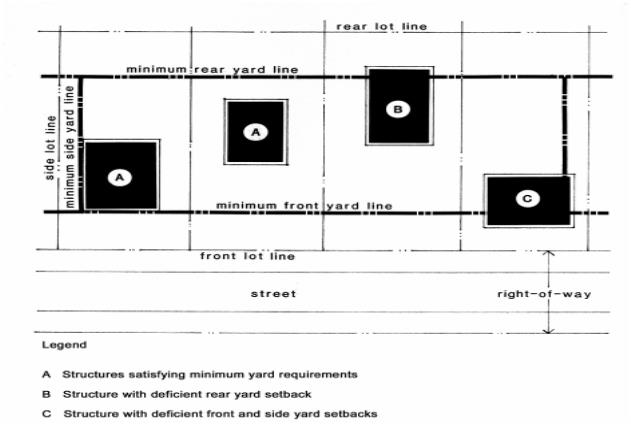
Figure 15. Setback Terms
Site Plan. A plan to scale, showing uses and structures proposed for parcel of land as required by the regulations involved. It includes lot lines, streets, building sites, reserved open space, building, major landscape features-both natural and man-made; and, depending on requirements, the locations of proposed utility lines.
Special Exception Permit. A use specified in this ordinance as permissible in a specific use district only after special conditions are met.
Story. That part of a building, other than a mezzanine, included between the surface of one floor and the surface of the floor next above, or if there be no floor above, that part of the building which is above the surface of the highest floor thereof. Specifically:
A. Top Story Attic. A half story when the main line of the eaves is not above the middle of the interior height of said story.
B. First Story. The highest story having its interior floor surface not more than four feet above the curb level, or the average elevation of the finished grade along the front of the building were it set back from the street.
C. Basement. That portion of a building wholly or partly below grade, but so constructed that the vertical distance from the average grade to the basement floor is greater than the vertical distance from the average grade to the basement ceiling. A basement shall not be included as a story for height measurement. A basement is considered a story if over fifty percent (50%) of its height is above the level from which the height of the building is measured. (See Figure 16. Determination of Basement vs. Story)
D. Half-story. that part of a building between a pitched roof and the uppermost full story, such part having a floor area which does not exceed one-half (1/2) of the floor area of such full story, provided the area contains at least two-hundred (200) square feet, with a clear height of at least seven (7) feet six (6) inches.
E. Mezzanine. A full story when it covers more than thirty-three percent (33%) of the area of the story underneath such mezzanine or if the vertical distance from the floor next below it to the floor next above it is twenty-four (24) feet or more.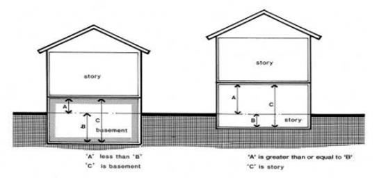
Figure 16. Determination of Basement vs. Story
Street. A dedicated and accepted public street, or a permanent unobstructed private easement of access with a roadway suitable for vehicular travel at least ten feet wide which affords the principal means of vehicular access to abutting property; such private easement having a right-of-way of 60 feet or more, excepting where an easement of access of lesser width exists prior to the adoption of this ordinance. Where under the provisions of Mapped Improvements Act, Act 22, P.A. 1943, the city commission has adopted a precise plat showing the exact location of proposed future outside lines of new, extended or widened streets, such outside lines shall constitute a street as above defined for the purpose of this ordinance, including provisions for required setback.
Street Type.
A. A Street. A streets connect to and are part of the regional road system. The purpose of these streets is generally to facilitate free traffic flow with 35 mph or greater speed limits and to accommodate higher traffic volumes exceeding 15,000 cars per day. A Streets typically have right-of-way sections of 120 feet or wider.
B. B Street. B streets distribute traffic within the City. B Streets can accommodate cross-town traffic, but are not part of the regional road system. B streets generally have a maximum 35 mph speed limit and accommodate moderate traffic volumes of 10,000 to 20,000 cars per day. B Streets typically have right-of-way sections greater than 60 feet in width.
C. C Street. C streets provide local access to parcels from A and/or B streets. C streets are not intended to accommodate high volumes of traffic or long distance trips, and generally have maximum 25 mph speed limits and accommodate low traffic volumes below 10,000 cars per day. C Streets typically have 60 foot or less right-of-way width.
Structure. Any constructed or erected materials or combination of materials the use of which requires location on or connection to the ground; including, but not limited to buildings, stadia, radio towers, sheds, storage bins, fences and signs.
Use, Accessory. A subordinate use which is customarily incidental to the principal use on the same lot. (See section 2.9 “Building, Principal,” “Building, Accessory,” and section 2.6 “Lot.”)
Used. This term is synonymous with the terms “use” and “uses” and means the purpose for which land or premises or a building thereon is designed, erected, arranged, or intended, or for which it is occupied or maintained, let or leased.
Yard. An open space other than a courtyard located on the same lot as a main building or use, unoccupied or unobstructed from the ground upward, except as otherwise provided herein. In measuring to determine the width of a yard, the minimum horizontal distance between the lot line and the main building shall be used. See Figure 17. Yard Terms.
A. Front yard. An open space extending the full width of the lot, the depth of which is the minimum horizontal distance between the front lot line, a proposed right-of-way as indicated on the master thoroughfare plan, or a private road easement used for ingress and egress, whichever is closest to the building which is to be located on the property, and the nearest point of the main building.
B. Rear yard. An open space extending the full width of the lot, the depth of which is the minimum horizontal distance between the rear lot line or zoning district line, whichever is closer to the building, except for changes in the zoning districts involving only residential zoning districts, a proposed right-of-way as indicated on the master thoroughfare plan, or a private road easement used for ingress and egress, whichever is closest to the building which is to be located on the property, and the nearest point of the main building.
C. Side yard. An open space between a main building and the side lot line, extending from the front yard to the rear yard, the width of which is the horizontal distance from the nearest point of the side lot line or zoning district line, whichever is closer to the building, except for changes in the zoning districts involving only residential zoning districts, a proposed right-of-way as indicated on the master thoroughfare plan, or a private road easement used for ingress and egress, whichever is closest to the building which is to be located on the property, and the nearest point of the main building.
D. Side street yard. The area extending between the front yard and the rear yard situated between the side street lot line and the face of the principal building which is parallel to, or most nearly parallel to, the side street lot line.
E. Required yard. A yard, as defined herein, that occupies the area of a required setback.
F. Nonrequired Yard. A yard, as defined herein, that occupies the area between a required setback line and a principal building.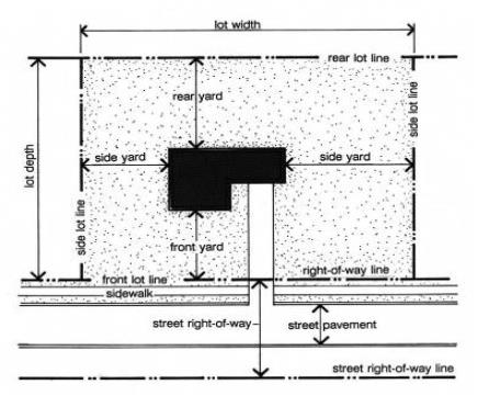
Figure 17. Yard Terms
Zoning Board of Appeals. The Zoning Board of Appeals of the City of Pontiac.
(Ord. No. 2361, 3-12-19; Ord. No. 2363, 4-9-19; Ord. No. 2413, 6-6-23; Ord. No. 2407, 4-4-23)