


Chapter 17.171
NEIGHBORHOOD CIRCULATION PLANS
Sections:
17.171.020 Adoption of neighborhood circulation plan.
17.171.030 Dawson Tract neighborhood circulation plan standards.
17.171.010 Purpose.
A neighborhood circulation plan may be created for a specific area in the city to address existing and proposed streets. The plan will provide for the optimum traffic flow considering the special limitations and opportunities present in the particular neighborhood. [Ord. 07-O-585.]
17.171.020 Adoption of neighborhood circulation plan.
Neighborhood circulation plans may be developed for appropriate areas. Such plans shall identify the street classification, projected average daily traffic (ADT), existing condition, design criteria and right-of-way and roadway width of all existing and projected street systems within the neighborhood circulation plan area. Within an adopted neighborhood circulation plan, right-of-way and roadway widths can be either the standards of BMC 17.170.060 or the standards of the circulation plan; provided, that once a standard has been established for a street segment, the remainder of the street will be constructed at that standard. [Ord. 07-O-585.]
17.171.030 Dawson Tract neighborhood circulation plan standards.
A. Dawson Tract Right-of-Way and Roadway Width Standards. Street right-of-way and roadway widths shall conform to the values shown in Table 17.171.030 or the standard right-of-way and road widths in Table 17.170.060. The Dawson Tract standards shall apply to all public and private streets in the Dawson Tract area, as defined in the Dawson Tract neighborhood circulation plan. Once a standard has been established by construction for any street segment, the remaining portion of the street shall be constructed at that standard.
B. Dawson Tract Neighborhood Circulation Plan Map. The neighborhood circulation plan map (see Map 17.171.030-1) is to be used in conjunction with the neighborhood circulation plan standards in Table 17.171.030. In the event of a conflict between the map and the table of standards, the table shall govern.
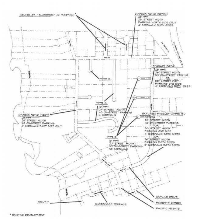
1. The neighborhood circulation plan offers alternative right-of-way and roadway widths for the main loop road of the Dawson Tract system (Dawson Road (North), Dawson Road (West), the Skyline/Passley connection, and Passley Road (see Table 17.171.030)). Pacific Heights (Dawson South), Shorewood Terrace, Ridgeway Street, and Skyline Drive are already developed to the standard minimum (see Table 17.171.030). North of Dawson Road North, Blueberry Drive (portion) and Holmes Court are also developed to the standard minimum.
2. For the area within the Dawson Road/Skyline/Passley loop, Type A and Type B cul-de-sac access streets are shown conceptually for single owner sites (see Map 17.171.030-3).
3. For the area north of Dawson Road North, a Holmes Drive/Blueberry Lane loop is anticipated. In addition, lane, place and private drive access shall be developed as required to serve future property divisions. Right-of-way and roadway widths, and location of these future streets, shall be approved by the planning commission as part of tentative plan approval. Approval shall be determined by the estimated average daily traffic (ADT) right-of-way and roadway widths shown in Table 17.171.030, Dawson Tract Right-of-Way and Roadway Width.
4. For “landlocked” tax lots located to the east of Passley Road, lane, place, and drive access in some combination will be required for service in order to further develop these sites, although no location is shown on the neighborhood circulation plan map. Access location, right-of-way, and roadway width shall be approved by the planning commission as part of tentative plan approval. Approval shall be determined by the estimated average daily traffic (ADT) right-of-way and roadway widths shown in Table 17.171.030, Dawson Tract Right-of-Way and Roadway Width.
Table 17.171.030
Dawson Tract Right-of-Way and Roadway Width
|
Street Name or Type |
Estimated ADT+ |
Right-of-Way Width (Feet) |
Roadway (Curb Face to Curb Face) Width (Feet) |
Minimum Sidewalk Width (Feet) |
Curbs Square Curb (SC) Rolled Curb (RC) Gutter (GT) Gravel Shoulder (GS) |
|
Dawson Road (North•) |
1,400 |
50 |
28* |
4 – Both sides Park on north |
SC/GT |
|
Dawson Road (West•) |
800 |
50 |
26** |
4 – East side |
SC/GT |
|
Pacific Heights•• |
|
50 |
36 |
5 – Both sides |
SC/GT |
|
Shorewood Terrace•• |
|
50 |
36 |
5 – One side |
SC/GT |
|
Skyline Drive•• |
|
50 |
36 |
5 – Both sides |
SC/GT |
|
Ridgeway Street•• |
|
50 |
36 |
5 – Both sides |
SC/GT |
|
Passley Road |
800 |
50 |
26**/30* |
4 – Both sides |
SC/GT |
|
Skyline/Passley Connector |
800 |
50 |
26**/30*/36 |
5 – Both sides |
SC/GT |
|
Holmes/Blueberry Loop (Future) |
|
|
|
|
|
|
Type A (cul-de-sac) 50 lot maximum 750 feet maximum length |
400 |
45 |
24**/30* |
4 – One side |
RC |
|
Type B (cul-de-sac) 12 lot maximum 400 feet maximum length |
100 |
45 |
20**/30* |
4 – One side |
RC |
|
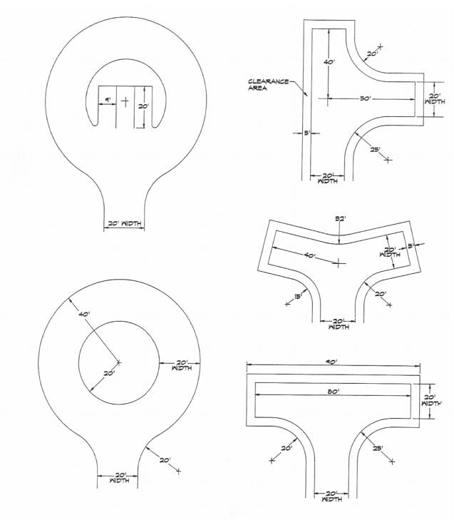
Cul-de-sac radius or hammerhead dimensions |
See Map 17.171.030-3 |
See Map 17.171.030-3 |
N/A |
One side |
|
|
Private (private drive) 6 lot maximum |
60 |
20*** |
N/A |
|
GS |
|
• Existing, improved one side only. |
|||||
|
•• Existing, improved both sides. |
|||||
|
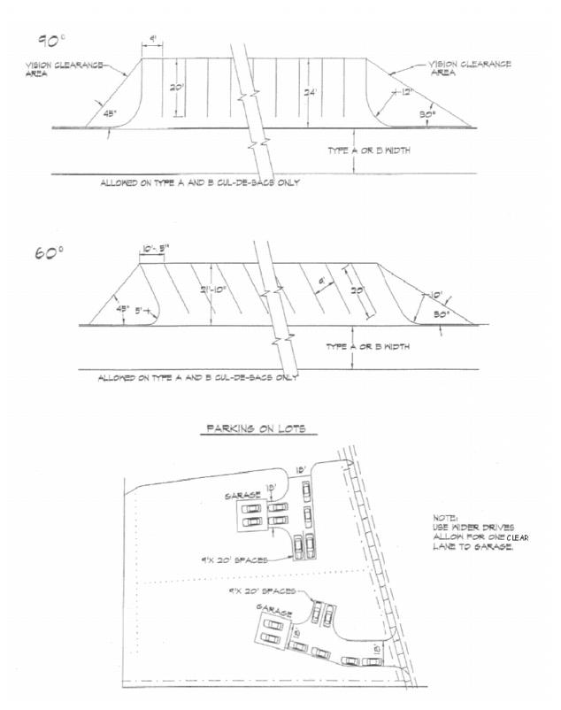
* Parking one side only. Lots serviced by no-parking side shall provide six off-street parking spaces in parking bays or on each lot. Add 1,500 square feet to minimum lot size. (See Map 17.171.030-2.) |
|||||
|
** No on-street parking. All lots serviced by no-parking streets shall provide six off-street parking spaces in parking bays or on each lot. Add 1,500 square feet to minimum lot size. (See Map 17.171.030-2.) |
|||||
|
*** For properties landlocked, or impacted by steep slopes, geological or soil hazards, or unusual parent parcel dimensions. No on-street parking permitted. Lots serviced by drives shall provide six off-street parking spaces in parking bays or on each lot. Add 1,500 square feet to minimum lot size. (See Map 17.171.030-2.) |
|||||
|
+ ADT = Average daily traffic. (For mixed family/retirement area, computed at eight ADT per dwelling unit.) |
|||||
Map 17.171.030-1
Dawson Tract Neighborhood Circulation Plan Map
Map 17.171.030-2
Dawson Tract Neighborhood Circulation Plan Parking Examples
Map 17.171.030-3
Dawson Tract Neighborhood Circulation Plan Turn-Around Options
for Type A and Type B Cul-de-Sacs
[Ord. 07-O-585.]