


Chapter 16.20
GENERAL REGULATIONS AND DESIGN
Sections:
16.20.060 Land for public purposes.
16.20.080 Land subject to inundation.
16.20.010 Streets.
A. Streets and Highways Conform with Plans and Standards. In addition to conformance with state laws and the standards provided by Chapters 16.04 to 16.24 CMC, the subdivision shall conform as to design and improvements to any master plan approved by the planning commission and to any proceedings affecting the subdivision which may have been initiated by the planning commission or approved by the council upon initiation by other legally constituted bodies of the city, county, or state. In addition, consideration shall be given to preliminary plans developed by the city.
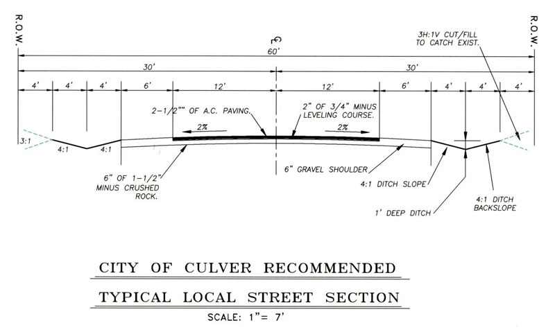
B. Street Design Standards.
1. Unless otherwise indicated on any master plan, or by proceedings initiated by the planning commission, or approved by the planning commission upon initiation by other legally constituted governmental bodies, roadway design shall conform with city standards shown below, except where it can be shown by the subdivider, to the satisfaction of the planning commission, that the topography or the small number of lots served and the probable future traffic development are such as to unquestionably justify a modified feature. Any modification must be approved by the city engineer and adequately justified, prepared and sealed by a licensed professional engineer. Increased widths may be required where streets are to serve commercial property, or where probable traffic conditions warrant. Approval or determination of street and area classification shall be made by the planning commission, taking into consideration the zoning designations imposed by CMC Title 17, the present use and development of the property in the area, the logical and reasonable prospective development of the area based upon public needs and trends, and the public safety and welfare.
2. Minimum Right-of-Way and Roadway Width. Unless otherwise approved in the tentative development plan, the street right-of-way and roadway surfacing widths shall not be less than the minimum width in feet shown in the table below and other applicable city standards and specifications. Where conditions, particularly topography, or the size and shape of land parcels make it impractical to provide buildable lots, narrower right-of-way may be accepted, ordinarily not less than 40 feet. If necessary, slope easements may be required.
3. Roadway alignment and grades must be designed in accordance with good engineering practice. Grades shall not exceed 10 percent on collector streets and 12 percent on local streets, with a minimum grade of one-half percent on all streets. The centerline radius of curves shall be not less than 150 feet on collector streets and 75 feet on local streets. Streets shall be designed to intersect at right angles wherever possible and shall comply with the following:
a. Substantial grade changes shall be avoided at intersections.
b. The intersection between two collector streets shall have a minimum of 100 feet of straight (tangent) alignment perpendicular to the intersection. Maximum design grade is two percent in this area.
c. The intersection of the local street with any other street shall have a minimum of 50 feet of straight (tangent) alignment perpendicular to the intersection. Maximum design grade is three percent in this area.
d. Where right angle intersections are not possible, exceptions can be granted by the city engineer, provided the intersections have a minimum interior angle of 60 degrees and a corner radius of 20 feet along the right-of-way lines of the acute angle.
e. Intersections of collector streets and established truck routes shall have a minimum corner radius of 20 feet.
f. All other intersections shall have a minimum corner radius of 15 feet.
|
ITEM |
LOCAL STREET |
COLLECTOR STREET |
|---|---|---|
|
Right-of-Way Width (feet) |
60 |
80 |
|
Pavement Width (feet) |
24 |
36 |
|
Shoulder Width (feet) |
6 |
N/A |
|
Sidewalks (feet) |
N/A |
5 |
|
Minimum Sight Distance (feet) |
150 |
150 |
|
Maximum Grade (%) |
12 |
10 |
|
Design Speed (mph) |
15 – 25 |
25 – 35 |
|
Minimum Centerline Curve Radius (feet) |
75 |
150 |
|
Minimum Curb/Corner Radius (feet) |
15 |
20 |
C. Future Streets. Whenever the planning commission shall have determined that, in conformity with the master plan, a street is necessary for the future subdivision of the property as shown on the subdivision map, but that the present dedication and construction of such street is not warranted, the planning commission may require that the location, width, and extent of such street shall be shown on the final map or on an approved map of record as a future street. Improvement of such future street may not be required of the subdivider by the planning commission.
D. Future Street Extension. Where necessary to give access to or permit a satisfactory future subdivision of adjoining land, streets shall extend to the boundary of the subdivision and the resulting dead-end streets may be approved without a turnaround. Reserve strips, including street plugs, may be required to preserve the objectives of street extensions.
E. Service Roads. When any lot fronts on a major street, the planning commission may require the subdivider to dedicate a service road at the front of the lot.
F. Reserved Strips. No reserved strips controlling the access to public ways will be approved unless the strips are necessary for the protection of the public welfare, and in these cases they may be required. The control and disposal of the land comprising the strips shall be placed within the jurisdiction of the city under conditions approved by the planning commission.
G. Half-Streets. Half-streets shall be prohibited, except they may be approved where essential to the reasonable development of the subdivision when in conformity with the other requirements of these regulations, and when the planning commission finds it will be practical to require the dedication of the other half when the adjoining property is subdivided. Whenever a half-street is adjacent to a tract to be subdivided, the other half of the street shall be platted within the tract. Reserve strips may be required to preserve the objectives of half-streets.
H. Nonaccess and Planting Strips. When the rear or side of any lots border any major street, the planning commission may require the subdivider to execute and deliver to the city an instrument deemed sufficient by the city attorney prohibiting the right of ingress and egress to the lots across the side lines of the street. When the street is a freeway, state highway, or parkway, the subdivider may be required to dedicate and improve a planting strip adjacent to the street.
I. Alleys. When any lots are proposed for commercial or industrial usage, alleys at least 20 feet in width may be required at the rear thereof with adequate ingress and egress for truck traffic, unless alternative commitments for off-street service truck facilities without alleys are approved. Intersecting alleys shall not be permitted.
J. Private Streets. The design and improvement of any private street shall be subject to all the requirements prescribed by this title for public streets. The subdivider shall provide for the permanent maintenance of any street required for access to property in a private street subdivision.
K. Street Names. All street names shall be approved by the planning commission and county roadmaster for conformance with the established pattern and to avoid duplication and confusion. [Ord. 01-02 § 3 (Exh. 3 § 26), 2001.]
16.20.020 Utility easements.
Easements for sewers, drainage, water mains, public utility installations, including overhead or underground systems, and other like public purposes shall be dedicated, reserved, or granted by the subdivider in widths not less than five feet on each side of rear lot lines, alongside lot lines, and in planting strips wherever necessary; provided, that easements of lesser width, such as for anchorage, may be allowed when the purpose of easements may be accomplished by easements of lesser width as approved by the city. [Ord. 01-02 § 3 (Exh. 3 § 27), 2001.]
16.20.030 Lots.
A. The size and shape of lots shall conform to zoning regulations. Where there are unusual topographic conditions, curved or cul-de-sac streets, or other special conditions, modifications which meet the intent of the width and depth requirements may be granted by the planning commission.
B. In areas that cannot be connected to community sewage disposal facilities, minimum lot sizes shall be greater than the minimum herein specified. The lots shall conform to the requirements of the county health department for sanitary waste disposal.
C. The side lines of all lots, so far as possible, shall be at right angles to the street which the lots face, or radial or approximately radial if the street is curved; provided, however, where topographic or other natural features warrant variation from this provision, the planning commission may approve such variations.
D. Lots without frontage on a street will not be permitted.
E. Through lots will be permitted only where necessitated by topographic or other unusual physical conditions. [Ord. 01-02 § 3 (Exh. 3 § 28), 2001.]
16.20.040 Blocks.
A. Blocks shall not exceed 1,320 feet in length, except blocks adjacent to major streets.
B. The subdivider may be required to dedicate and improve 10-foot walkways across blocks over 600 feet in length, or to provide access to schools, parks, or other public areas. [Ord. 01-02 § 3 (Exh. 3 § 29), 2001.]
16.20.050 Watercourses.
The subdivider shall, subject to riparian rights, dedicate a right-of-way for storm drainage purposes, conforming substantially with the lines of any natural watercourse or channel, stream, or creek that traverses the subdivision; or, at the option of the subdivider, provide by dedication further and sufficient easements or construction, or both, to dispose of the surface and storm waters. [Ord. 01-02 § 3 (Exh. 3 § 30), 2001.]
16.20.060 Land for public purposes.
A. The planning commission may require the reservation for public acquisition, at a cost not to exceed acreage values in the area prior to subdivision, of appropriate areas within the subdivision for a period not to exceed one year; providing the city has an interest or has been advised of interest on the part of the State Highway Commission, school district, or other public agency to acquire a portion of the area within the proposed subdivision for a public purpose, including substantial assurance that positive steps will be taken in the reasonable future for the acquisition.
B. The planning commission shall require a cash payment for the city park development and equipment acquisition. The cash payment shall be an amount that is five percent of the assessed market value of the undeveloped land which is being subdivided or partitioned. [Ord. 01-02 § 3 (Exh. 3 § 31), 2001.]
16.20.070 Unsuitable land.
The planning commission may refuse to approve a subdivision when the only practical use which can be made of the property proposed to be subdivided is a use prohibited by this title or law, or if the property is deemed unhealthful or unfit for human habitation or occupancy by the county or state health authorities. [Ord. 01-02 § 3 (Exh. 3 § 32), 2001.]
16.20.080 Land subject to inundation.
If any portion of any land proposed for development is subject to overflow, inundation, or flood hazard by storm waters, an adequate system of storm drains, levees, dikes, and pumping systems shall be provided. [Ord. 01-02 § 3 (Exh. 3 § 33), 2001.]