


Chapter 1.3
Definitions
Sections:
1.3.100 Purpose
The purpose of Chapter 1.3 is to define terms that are used in the Halsey Development Code and other terms that may arise in interpreting the Code, particularly those that may be uncommon or have more than one meaning.
1.3.110 Applicability
A. Definitions. The definitions in Chapter 1.3 apply to all actions and interpretations under the Halsey Development Code. The meanings of some terms in this chapter may, in certain contexts in which they are used, be clearly inapplicable. In such cases the context in which a term is used will indicate its intended meaning, and that intent shall control.
B. When a Term is Not Defined. Terms not defined in this Code shall have their ordinary accepted meanings within the context in which they are used. [Webster’s Third New International Dictionary of the English Language, Unabridged,] shall be considered a standard reference.
C. Conflicting Definitions. Where a term listed in Chapter 1.3 is defined by another section of this Code or by other regulations or statutes referenced by this Code, the term is not redefined herein for purposes of that other code or regulation.
1.3.120 Definitions
Abutting - Contiguous or adjoining. It shall include the terms adjacent, adjoining and contiguous.
Access – A way or means of approach to provide pedestrian, bicycle, and/or motor vehicular entrances or exits to a property.
Access Control - Where the right of access between a property abutting the street/highway and the street/highway has been acquired by a roadway authority, or eliminated by law, pursuant to access or approach spacing standards.
Access Easement - An easement conveyed for the purposed of providing vehicle, bicycle, and/or pedestrian access from a public street to a lot or parcel across intervening property under separate ownership from the parcel being provided access. A “Cross Access Easement” is an easement providing 7vehicular access between two or more separate sites, so that the driver need not enter the public street system between sites.
Access Management - The control of street (or highway) access for the purpose of improving the efficiency, safety and/or operation of the roadway for vehicles; may include prohibiting, closing, or limiting direct vehicle access to a roadway from abutting properties, either with physical barriers (curbs, medians, etc.) or by land dedication or easement. See also, Chapter 3.2 “Access and Circulation”.
Access Point - A connection providing for the movement of vehicles between a lot or parcel and a public roadway.
Access Spacing/Intersection Spacing - The minimum required distance from an intersection of a public or private street to the nearest driveway or other access connection, measured from the closest edge of the pavement of the intersecting street to the closest edge of the pavement of the connection along the traveled way.
Access Way - A walkway providing a through connection for pedestrians between two streets, between two lots, or between a development and a public right-of-way. It may be an access way for pedestrians and bicyclists (with no vehicle access), or a walkway on public or private property (i.e., with a public access easement); it may also be designed to accommodate emergency vehicles. See also, Walkway.
Accessible - Approachable and useable by people with disabilities. Complies with the Americans With Disabilities Act.
Accessory Dwelling - See Chapter 2.2, Section 2.2.200.A.
Accessory Use/Accessory Structure - A structure of secondary importance or function on a site. In general, the primary use of the site is not carried on in an accessory structure. Accessory structures are detached from the primary structure. Examples of accessory structures include, but are not limited to, garages, storage sheds, workshops, decks, fences, arbors, gazebos and other similar structures. See also, Primary Structure. See Chapter 2.2, Section 2.2.200.J.
Adjacent - Abutting or located directly across a street right-of-way.
Administrative - A discretionary action or permit decision made without a public hearing.
Adverse Impact - Negative effect of development that can be measured (e.g., noise, air pollution, vibration, dust, etc.).
Affordable Housing - Housing affordable to a certain percentage of the population earning a specified level of income and spending no more than 30 percent of household income on housing expenses. For more information, refer to the Federal Department of Housing and Urban Development and the Oregon Department of Housing and Community Services.
Agriculture - As used in this Code, “agriculture” is the same as “farm use.” See also, ORS 215.203(2)(a).
Alley - See Chapter 3.5., Section 3.5.110.R.
Alteration of a Watercourse - Includes, but is not limited to, any dam, culvert, impoundment, channel relocation, change in channel alignment, channelization, or change in cross-sectional area or capacity, which may alter, impede, retard or change the direction and/or velocity of the riverine flow of water during conditions of the base flood.
Ambient - Something that surrounds, as in the level of light, dust or noise.
Area of Shallow Flooding - A designated AO or AH Zone on a community’s Flood Insurance Rate Map (FIRM) with base flood depths from one to three feet, and/or where a clearly defined channel does not exist, where the path of flooding is unpredictable and indeterminate, and where velocity flow may be evident.
Arcade - An arched or covered passageway; often along building fronts or between streets.
Area of Special Flood Hazard - The land in the floodplain within a community subject to a one percent or greater chance of flooding in any given year. Zone designations on the Flood Insurance Rate Map (FIRM) include the letters A or V. Also known as the Special Flood Hazard Area (SFHA).
Arterial - An arterial street. See Chapter 3.5, Section 3.5.110 and Table 3.5.110.H - Street Design Standards.
Articulate/Articulation - The jointing and interrelating of building spaces through offsets, projections, overhangs, extensions and similar features.
Automobile-Oriented Use - See Chapter 2.3, Section 2.3.180.E.
Base Flood - means the flood having a one percent chance of being equaled or exceeded in any given year (i.e., 100-year Flood).
Base Flood Elevation (BFE) - The water surface elevation during the base flood in relation to a specified datum. The Base Flood Elevation (BFE) is depicted on the Flood Insurance Rate Map (FIRM) to the nearest foot and in the Flood Insurance Study (FIS) to the nearest 0.1 foot.
Basement - The portion of a structure with its floor sub grade (below ground level) on all sides.
Bed and Breakfast Inn - Provides accommodations (3 or more rooms for rent on a daily basis) plus meal service as provided in ORS 624.046 as part of the cost of the room in an operator- or owner-occupied home that is primarily used for this purpose. This use is operated as a commercial enterprise, encourages direct bookings from the public, and is intended to provide a major source of income to the proprietors. This level includes inns that operate restaurants offering meals to the general public as well as to overnight guests. Note: See ORS 624.010 and OAR 333.170 for additional requirements from the Oregon Health Authority, Public Health Division.
Below-Grade Crawlspace - An enclosed area below the Base Flood Elevation in which the interior grade is not more than two feet below the lowest adjacent exterior grade and the height, measured from the interior grade of the crawlspace to the top of the crawlspace foundation, does not exceed 4 feet at any point.
Berm - A small rise or hill in a landscape which is intended to buffer or visually screen certain developments, such as parking areas.
Beveled Building Corner - A rounded or flat edge on a building, usually at a street corner; may include an entrance, windows, pillars, or other architectural details and ornamentation.
Block - All of the property bounded by streets, rights-of-way (pedestrian or vehicle ways), water features, or any combination thereof, but is not divided or separated in any way by streets or water features. See also, Chapter 3.2, Section 3.2.120.I.
Bollard - A post of metal, wood or masonry that is used to separate or direct traffic (vehicles, pedestrians and/or bicycles). Bollards are usually decorative and may contain sidewalk or pathway lighting.
Building - A building or structure subject to Building Codes.
Building Codes - The Oregon Building Codes and Specialty Codes approved by the Oregon Building Codes Division and the Linn County Planning and Building Department, but does not include regulations adopted by the State Fire Marshall pursuant to ORS Chapter 476 or ORS 479.015 to 479.200 and ORS 479.210 to 479.220.
Building Footprint - The outline of a building, as measured around its foundation.
Building Mass - The aggregate size of a building, or the total height, width, and depth of all its parts.
Building Official - The person who enforces the State Building Code, related specialty codes, derelict and dangerous building ordinances and other related ordinances and regulations as assigned. Note: The City of Halsey contracts with Linn County for building inspection services. The Linn County Building Official is the City of Halsey Building Official.
Building Pad - A vacant building site on a lot with other building sites.
Building Scale - The dimensional relationship of a building and its component parts to other buildings.
Capacity - Maximum holding or service ability, as used for transportation, utilities, parks and other public facilities.
Carport - A stationary structure consisting of a roof, its supports, and not more than one wall or storage cabinets substituting for a wall, used to shelter motor vehicles, recreational vehicles, or boats; does not include temporary shelters or canopies not affixed to a permanent foundation per applicable building codes.
Centerline radius - The radius of a curved centerline of a street right-of-way.
Change of Use - Change in the primary type of use on a site.
Child Care Facility, Child Care Center, Family Child Care - Facilities that provide care and supervision of minor children for periods of less than 24 hours. “Family child care providers” provide care for not more than 12 children in a home. See also, OAR Chapter 414 for certification requirements.
City Administrator/City Recorder - The City Administrator/City Recorder of the City of Halsey, or designee. Note: The City Administrator serves as the City Recorder in the City of Halsey, Oregon.
City Planner – The City Administrator or other person designated by the City Administrator to serve as the planning official for the City of Halsey, Oregon.
Clear and Objective - Relates to decision criteria and standards that do not involve substantial discretion or individual judgment in their application.
Code – The Halsey Development Code.
Collector - Type of street. See Chapter 3.5, Section 3.5.110 and Table 3.5.110.H “Street Design Standards”.
Commercial - Land use involving buying/selling of goods or services as the primary activity.
Common Area - Land jointly commonly owned to include open space, landscaping or recreation facilities (e.g., may be managed by a homeowner’s association).
Comprehensive Plan - The Comprehensive Plan of the City of Halsey.
Conditional Use - A use which requires a Conditional Use Permit. See Chapter 4.5.
Consensus - Agreement or consent among participants.
Corner radius - The radius of a street corner, as measured around the curb or edge of pavement.
Cornice - The projecting horizontal element that tops a wall or flat roof. See Chapter 2.3, Section 2.3.160.
Cottage - A small house that may be used as an accessory dwelling, in conformance with Chapter 2.2, Section 2.2.200.A.
Council/City Council - The City Council of the City of Halsey, Oregon.
County - Linn County, Oregon.
Courtyard - A court or enclosure adjacent to a building, which usually provides amenities such as gardens, planters, seating, or art.
Critical Facility - A facility that is critical for the health and welfare of the population and is especially important following hazard events. The following is a list of critical facilities:
1. Hospitals and other medical facilities having surgery and emergency treatment areas;
2. Fire and police stations;
3. Tanks or other structures containing, housing or supporting water or fire-suppression materials or equipment required for the protection of essential or hazardous facilities or special occupancy structures;
4. Emergency vehicle shelters and garages;
5. Structures and equipment in emergency-preparedness centers;
6. Standby power generating equipment for essential facilities; and
7. Structures and equipment in government communication centers and other facilities required for emergency response.
Curb Cut - A driveway opening in a curb along a street.
Days - Calendar days, unless specifically stated as working days. Working days include Monday through Friday, excluding federal holidays.
Deciduous - Tree or shrub that sheds its leaves seasonally.
Dedication - The designation of land by its owner for any public use as shown on a subdivision plat or deed. The term may also be used for dedications to a private homeowner’s association.
Density - A measurement of the number of dwelling units in relationship to a specified amount of land (e.g. 10 dwelling units per acre). As used in this Code, density does not include land devoted to street right-of- way (also known as net density).
Developable - Buildable land, as identified by the City’s Comprehensive Plan. Includes both vacant land and land likely to be redeveloped, per ORS 197.295(1).
Development - All improvements on a site, including buildings, other structures, parking and loading areas, landscaping, paved or graveled areas, grading, and areas devoted to exterior display, storage, or activities. Development includes improved open areas such as plazas and walkways. Also, a development site or area.
As applied to regulations contained in Chapter 3, Chapter 4 and Chapter 5, development is any man-made change to improved or unimproved real estate, including but not limited to buildings or other structures (including fences and walls), mining, dredging, filling, grading, paving, excavation or drilling operations or storage of equipment or materials located within the Area of Special Flood Hazard.
Digital FIRM (DFIRM) - Digital Flood Insurance Rate Map. It depicts flood risk and zones and flood risk information The DFIRM presents the flood risk information in a format suitable for electronic mapping applications.
Discontinued/Abandoned Use - A use that physically left the land it was on, a permitted use that ceased, or a use terminated at the end of a lease or contract. See Chapter 5.3 - Non-Conforming Uses and Developments.
Discretionary - A permit action or decision that involves substantial judgment or discretion.
Drip-Line - Imaginary line on the ground around a tree or shrub at a distance from the trunk equivalent to the spread of the leaf canopy.
Drive Lane/Travel Lane - An improved (e.g., paved) driving surface for one line of vehicles.
Drive-Through/Drive-Up Facility - A facility or structure that is designed to allow drivers to remain in their vehicles before and during an activity on the site. Drive-through facilities may serve the primary use of the site or may serve accessory uses. Examples are drive-up windows; automatic teller machines; coffee kiosks and similar vendors; menu boards; order boards or boxes at a fast-food restaurant; gas pump islands; car wash facilities; auto service facilities, such as air compressor, water, and windshield washing stations; quick-lube or quick-oil change facilities; and drive-in theaters.
Driveway - Area that provides vehicular access to a site or the area that provides vehicular circulation on a site, not including a public or private street. A driveway begins at the property line and extends into the site. Driveways do not include parking spaces, storage areas, loading areas, maneuvering areas, or circulation areas.
Driveway Apron/Approach - The edge of a driveway where it abuts a public right-of-way; usually constructed of asphalt or concrete. See Chapter 3.2, Section 3.2.120.O. Note: The design standards of the applicable roadway authority apply. See also, Oregon Administrative Rules 734, Division 51, for definitions specific to state highways.
Driveway, Shared - When land uses on two or more lots or parcels share one driveway. An easement or tract (owned in common) must be created and recorded for this purpose.
Drought-Tolerant/Drought-Resistant Plants - Refer to Sunset Western Garden Book (latest edition). Plants that require no summer watering once established.
Duplex – See definition under “Dwelling”.
Dwelling - A structure conforming to the definition of a dwelling under applicable building codes and providing complete, independent living facilities for one or more persons, including permanent provisions for living, sleeping, eating, cooking, and sanitation.
For the purposes of this Code, the following types of dwelling units are defined:
Accessory Dwelling - A secondary dwelling unit on a lot where the primary use is a single-family dwelling.
Attached, Single-Family (Townhome) - A dwelling unit located on its own lot that shares one or more common or abutting walls with one or more dwelling units on adjacent lot(s).
Duplex Dwelling - A structure that contains two primary dwelling units on one lot. The units must share a common wall or common floor/ceiling.
Dwelling Unit - A building, or a portion of a building, that has independent living facilities including provisions for sleeping, cooking, and sanitation, and that is designed for residential occupancy. Buildings with more than one set of cooking facilities are considered to contain multiple dwelling units or accessory dwelling units, as applicable, unless the additional cooking facilities are clearly accessory to the primary use, such as an outdoor grill or wet bar.
Manufactured Home - A structure constructed for movement on the public highways that has sleeping, cooking, and plumbing facilities; that is intended for human occupancy; that is being used for residential purposes; and that was constructed in accordance with federal manufactured housing construction and safety standards and regulations in effect at the time of construction.
Mobile Home - A structure constructed for movement on the public highways that has sleeping, cooking, and plumbing facilities; that is intended for human occupancy; that is being used for residential purposes; and that was constructed between January 1, 1962, and June 15, 1976, and met the construction requirements of Oregon mobile home law in effect at the time of construction.
Multifamily Development - A structure or grouping of structures containing three or more dwellings on the same lot.
Multifamily Structure - A structure containing three or more dwelling units. The land underneath the structure is not divided into separate lots.
Residential Home is a residential treatment or training or adult foster home licensed by or under the authority of the Department of Human Services, under ORS 443.400 to 443.825, a residential facility registered under ORS 443.480 to 443.500, or an adult foster home licensed under ORS 443.705 to 443.835 that provides residential care alone or in conjunction with treatment or training or a combination thereof for five or fewer individuals who need not be related. See also, ORS 197.660.
Residential Facility is defined under ORS 430.010 (for alcohol and drug abuse programs), ORS 443.400 (for persons with disabilities), and ORS 443.880; residential facilities provide housing and care for 6 to 15 individuals who need not be related. Staff persons required to meet state licensing requirements are not counted in the number of facility residents and need not be related to each other or the residents.
Senior Housing - Housing designated and/or managed for persons over a specified age. Specific age restrictions vary, and uses may include assisted living facilities, retirement homes, convalescent or nursing homes, and similar uses not otherwise classified as Residential Homes or Residential Facilities.
Single-Family, Detached Dwelling - A detached dwelling unit located on its own lot.
Easement - A grant of rights by a property owner that allows others to use the owner’s land for a specific purpose, such as access, or to locate utilities. Recorded and on record at Linn County.
Elevation - Refers to a building face, or scaled drawing of the same, from grade to roof ridgeline.
Encroachment - The advancement or infringement of uses, fill, excavation, buildings, permanent structures or other development into a floodway which may impede or alter the flow capacity of a floodplain.
Elevated Building - A non-basement building which has its lowest elevated floor raised above ground level by foundation walls, shear walls, post, piers, pilings, or columns.
Evidence - Application materials, plans, data, testimony and other factual information used to demonstrate compliance or non-compliance with a code standard or criterion.
Existing Building or Structure – For flood plain regulations in Chapter 3, an existing building or structure is any structure for which the “Start of Construction” commenced before September 29, 2010.
Family Day Care - See “child care facilities.”
Federal Emergency Management Agency (FEMA) - The agency with the overall responsibility for administering the National Flood Insurance Program.
Fire Apparatus Lane - A clear access way for emergency vehicles, as defined by the Uniform Fire Code.
Flag Lot - A lot or parcel which has access to a road, street or easement, by means of a narrow strip of the lot or an easement. See Chapter 2.2, Section 2.2.140.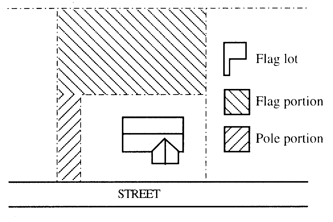
Flood or Flooding - A general and temporary condition of partial or complete inundation of normally dry land areas from:
1. The overflow of inland or tidal waters; or
2. The unusual and rapid accumulation or runoff of surface waters from any source.
Flood, 100-Year - Flood with a one percent chance of being equaled or exceeded in any given year. This is the flood most commonly used for regulatory purposes and is called the Base Flood. This flood event inundates the entire 100-year Floodplain. See Base Flood.
Flood Hazard Zone - Geographic areas that the Federal Emergency Management Agency has defined according to varying levels of flood risk. These Flood Hazard Zones are depicted on a community’s Flood Insurance Rate Map (FIRM) or on Floodplain study maps approved by the Floodplain Administrator or designee. Each Flood Hazard Zone reflects the severity or type of flooding in the area. The following list provides a description of the Flood Hazard Zones.
1. Flood Hazard Zone ‘A’ - Corresponds to the 100-year Floodplains that are determined in the Flood Insurance Study by approximate methods. Because detailed hydraulic analyses are not performed for such areas, no Base Flood Elevations or depths are shown within this zone. Mandatory flood insurance purchase requirements apply.
2. Flood Hazard Zone ‘AE’ - Corresponds to the 100-year Floodplains that are determined in the Flood Insurance Study by detailed methods. In most instances, Base Flood Elevations derived from the detailed hydraulic analyses are shown at selected intervals within this zone. Mandatory flood insurance purchase requirements apply.
3. Flood Hazard Zone ‘AH’ - Corresponds to the areas of 100-year shallow flooding with a constant water-surface elevation (usually areas of ponding) where average depths are between 1 and 3 feet. The Base Flood Elevations (BFEs) derived from the detailed hydraulic analyses are shown at selected intervals within this zone. Mandatory flood insurance purchase requirements apply.
4. Flood Hazard Zone ‘AO’ - Corresponds to the areas of 100-year shallow flooding (usually sheet flow on sloping terrain) where average depths are between one and three feet. The depth should be averaged along the cross section and then along the direction of flow to determine the extent of the zone. Average flood depths derived from the detailed hydraulic analyses are shown within this zone. In addition, alluvial fan flood hazards are shown as Zone AO on the FIRM. Mandatory flood insurance purchase requirements apply.
5. Flood Hazard Zone ‘A99’ - Corresponds to areas of the 100-year Floodplains that will be protected by a Federal flood protection system where construction has reached specified statutory milestones. No Base Flood Elevations or depths are shown within this zone. Mandatory flood insurance purchase requirements apply.
Floodplain - The area adjacent to a stream or river channel that is covered by water when the river or stream overflows its banks.
Floodplain Development Permit – A permit required prior to construction and other development in any Special Flood Hazard Area (100-yr. Floodplain).
Floodplain, 100-year - The land area adjacent to a river, stream, or other water body that is subject to a one percent or greater chance of flooding in any given year. It consists of land ranging from that which is subject to annual flooding to that which has a one percent or greater chance of flooding in any given year. The 100-year Floodplain consists of the Floodway and the Floodway Fringe. The 100- year Floodplain is mapped by the Federal Emergency Management Agency (FEMA) on Flood Insurance Rate Maps (FIRMs) and is the area subject to Base Flood regulations. Not every potential Area of Special Flood Hazard within the Urban Growth Boundary has been mapped by the Federal Emergency Management Agency through the Flood Insurance Study, Flood Insurance Rate Maps, and Digital Flood Insurance Rate Maps. The Floodplain Administrator is authorized in Chapter 3.7, Section 3.7.120 to obtain the information necessary to determine the presence and extent of unmapped Areas of Special Flood Hazard as part of reviewing development proposals that effect the 100-year Floodplain. Such information shall be used by the City of Halsey to supplement the Flood Insurance Study, Flood Insurance Rate Maps, and Digital Flood Insurance Rate Maps and these areas are also subject to Base Flood regulations. See Base Flood.
Flood Insurance Rate Map (FIRM) - An official map of a community, issued by the Federal Insurance Administration, delineating the areas of special flood hazard and/or risk premium zones applicable to the community.
Flood Insurance Study (FIS) - The official report by the Federal Insurance Administration evaluating flood hazards and containing flood profiles, floodway boundaries and water surface elevations of the base flood.
Floodway (Regulatory Floodway) - The channel of a river or other watercourse and those portions of the floodplain adjoining the channel required to discharge and store the floodwater or flood flows associated with the regulatory flood.
Floodway, 1.0-ft. – A river channel or other Watercourse and the adjacent land areas that must be reserved in order to discharge the Base Flood (100-year Flood) without cumulatively increasing the Water Surface Elevation more than 1.0 ft.
Floodway Fringe - The area of the 100-year Floodplain lying outside of the Floodway. Context is the 1.0-ft. Floodway. See Floodway.
Frontage - The dimension of a property line abutting a public or private street.
Frontage Street or Road - A minor street which parallels an arterial street in order to provide access to abutting properties and minimize direct access onto the arterial.
Functional Classification - The classification given to streets (e.g., “local/collector/arterial”) by the City’s Comprehensive Plan, by adopted County plans, and Oregon Department of Transportation.
Grade - The lowest point of elevation of the finished surface of the ground, paving, or sidewalk within the area between the building and the property line or, when the property line is more than five feet from the building, between the building and a line five feet from the building. Note: This is the definition used in the Oregon Structural Specialty Code (the International Building Code as amended by the State of Oregon).
Grading - All cuts, fills, embankments, stockpile areas, and equipment maneuvering areas associated with development.
Ground Cover - A low-growing plant or landscape material that is used to cover bare ground. See also, Chapter 3.3 - Landscaping.
Halsey Development Code (HDC) – The Halsey Development Code as adopted by the City of Halsey, Oregon (also referred to as “Code”).
Hammerhead Turnaround - A “T” or “L” shaped dead-end street that allows for vehicles to turn around.
Hardscape - Non-plant landscape materials, including pathways, decorative pavers, benches, drinking fountains, arbors, pergolas, playgrounds, plazas, and similar amenities.
Highest Adjacent Grade (HAG) - The highest natural elevation of the ground surface prior to construction, adjacent to the proposed walls of a structure. Refer to the Elevation Certificate, FEMA Form 81-31, for HAG for more information.
Historic Structure - A structure that is:
1. Listed individually in the National Register of Historic Places (a listing maintained by the U.S. Department of Interior) or preliminarily determined by the Secretary of the Interior as meeting the requirements for individual listing on the National Register;
2. Certified or preliminarily determined by the Secretary of the Interior as contributing to the historical significance of a registered historic district or to a district preliminarily determined by the Secretary to qualify as a registered historic district;
3. Individually listed on a state inventory of historic places and determined as eligible by states with historic preservation programs which have been approved by the Secretary of the Interior, or;
4. Individually listed on the local inventory of historic places included in the City of Halsey Comprehensive Plan.
Home Occupation/Home Occupation Site - A business activity that is carried out on the same site as a dwelling unit, and which is accessory to the residential use on the site, subject to the home occupation provisions in Chapter 4.9, Section 4.9.110.
Human-Scale Design/Development - Site and building design elements that are dimensionally related to pedestrians, such as: small building spaces with individual entrances (e.g., as is typical of downtowns and main street developments); larger buildings which have articulation and detailing to break up large masses; narrower streets with tree canopies; smaller parking areas or parking areas broken up into small components with landscaping; and pedestrian amenities, such as sidewalks, plazas, outdoor seating, lighting, weather protection (e.g., awnings or canopies), and similar features. These features are all generally smaller in scale than those which are primarily intended to accommodate automobile traffic.
Impervious Surface - Development features which do not allow for water infiltration (e.g., pavement, sidewalks, roofs, patios, etc.).
Incidental and Subordinate to - A use or portion of a development that is secondary to, and less apparent, than the primary use or other portion of the development.
Infill - The development of vacant or underdeveloped lands located in an area that is mainly developed, as opposed to on the outskirts of town.
Junk Yard - (1) Any property or establishment on which one or more persons are engaged in breaking up, dismantling, sorting, storing, distributing, buying or selling scrap or waste materials. (2) Any establishment or place of business on which 2 or more inoperable motor vehicles or an equivalent volume of waste or refuse are maintained, stored, bought or sold. Includes wrecking yards, automobile graveyards, garbage dumps, and scrap metal and other recycling processing facilities.
Land Division - The process of dividing land to create parcels or lots.
Land Use - The activity or activities that occur on a piece of land, or the structure in which the activity occurs (e.g., residential, commercial, mixed use, industrial, open space, recreation, street rights-of- way, vacant, etc.). Activities may be identified as primary or accessory uses.
Land Use Decision - A final decision or determination made by the City of Halsey (or other agency with jurisdiction) that concerns the adoption, amendment, or application of the Statewide Planning Goals, the Comprehensive Plan, this Code or any land use regulation where the decision requires the interpretation or exercise of policy or legal judgment (ORS 197.015). Note: All decisions requiring Quasi-Judicial review by the City of Halsey are Land Use Decisions. Decisions subject to Administrative review are considered Limited Land Use Decisions, pursuant to ORS 197.015.
Land Use District - As used in this Code, a land use district is the same as a zoning district.
Landing - A level part of a staircase, as at the end of a flight of stairs.
Landscaping - Any combination of living plants such as trees, shrubs, plants, vegetative ground cover or turf grasses, and may include structural features such as walkways, fences, benches, plazas, works of art, reflective pools, fountains or the like. Landscaping also includes irrigation systems, mulches, topsoil, and replanting or the preservation and protection of existing trees.
Legislative - A legislative action or decision is the making of law, as opposed to the application of existing law to a particular use (e.g., adoption of, or amendment to, a comprehensive plan or development regulation). See Chapter 4.2, Section 4.2.150.
Letter of Map Change (LOMC) - An official FEMA determination, by letter, to amend or revise effective Flood Insurance Rate Maps and Flood Insurance Studies. LOMCs are issued in the following categories:
1. Letter of Map Amendment (LOMA) - A revision based on technical data showing that a property was incorrectly included in a designated special flood hazard area. A LOMA amends the current effective Flood Insurance Rate Map and establishes that a specific property is not located in a special flood hazard area;
2. Letter of Map Revision (LOMR) - A revision based on technical data showing that, usually due to manmade changes, shows changes to flood zones, flood elevations, floodplain and floodway delineations, and planimetric features. One common type of LOMR, a LOMR-F, is a determination that a structure of parcel has been elevated by fill above the Base Flood Elevation and is excluded from the special flood hazard area;
3. Conditional Letter of Map Revision (CLOMR) - A formal review and comment by FEMA as to whether a proposed project complies with the minimum National Flood Insurance Program floodplain management criteria. A CLOMR does NOT amend or revise effective Flood Insurance Rate Maps, Flood Boundary and Floodway Maps, or Flood Insurance Studies.
Level of Service - For transportation, a standard of a street’s carrying capacity, based upon prevailing roadway, traffic and traffic control conditions during a given time period. The Level of Service range, from LOS A (free flow) to LOS F (forced flow) describes operational conditions within a traffic stream. Level of Service is normally measured for the peak traffic hour, at intersections or on street segments (between intersections).
Local Improvement District (LID) - A small public district formed for the purpose of carrying out local improvements (paving of streets, construction of storm sewers, development of a park, etc.). Property owners within the LID are assessed for the cost of the improvements in accordance with ORS 223.387-223.525. See also Chapter 3.5, Section 3.5.110.C.
Lot - A lot is a unit of land that is created by a land division. (ORS 92.010(3)). See also, Chapter 4.4.
Lot Area - The total surface area (measured horizontally) within the lot lines of a lot.
Lot Coverage - The area of a lot covered by a building or buildings expressed as a percentage of the total lot area.
Lot Line Adjustment/Property Line Adjustment - The adjustment of a property line by the relocation of a common line where no additional lots are created. This Code also includes the consolidation of lots (i.e., resulting in fewer lots) as a lot line adjustment. See examples below:
Examples of a Property Line Adjustment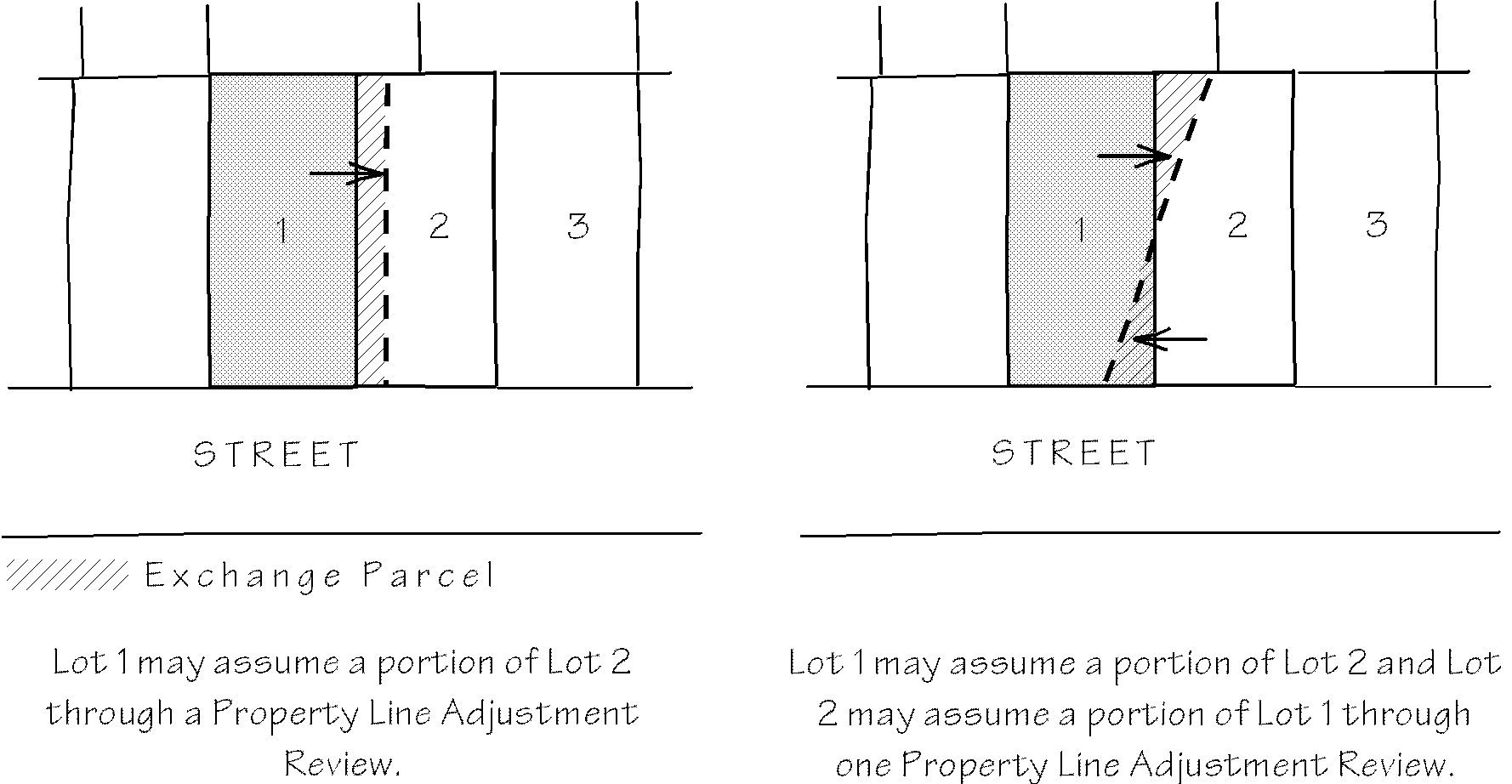
Lowest Floor - The lowest floor of the lowest enclosed area (including basement). An unfinished or flood resistant enclosure used solely for parking of vehicles, building access, or storage, in an area other than a basement, is not considered a structure’s lowest floor provided that the enclosed area is built and maintained in accordance with the applicable design requirements of the Building Code.
Main Entrance - A main entrance is the entrance to a building that most pedestrians are expected to use. Generally, smaller buildings have one main entrance. Main entrances may also be the widest entrance of those provided for use by pedestrians. In multi-tenant buildings, main entrances open directly into the building’s principal interior ground level circulation space. When a multi-tenant building does not have common interior circulation space, each tenant’s outside entrance is a main entrance.
Maneuvering Area/Aisle - The driving area in a parking lot where motor vehicles are able to turn around and access parking spaces.
Manufactured Home – See definition under “Dwelling”.
Manufactured Home Park - A group of manufactured homes on a single lot, as defined by ORS 446.
Mean Sea Level - For purposes of the National Flood Insurance Program, the North American Vertical Datum of 1988 or other datum, to which Base Flood Elevations shown on a community’s FIRM are referenced.
Mitigation - Compensation for negative impacts which result from other actions (e.g., improvements to a street may be required to mitigate for transportation impacts resulting from development.)
Mixed-Use - The combination of residential uses with commercial (e.g., office, retail, or services), civic, or light industrial uses on a site.
Mobile Home – See definition under “Dwelling”.
Multi-Family Development and Multi-Family Structure - See definitions under “Dwelling”.
Multi-Use Pathway - A non-automobile transportation and recreation route. See Chapter 3.2, Section 3.2.130.
Natural Elevation - The elevation of natural grade, or the grade in existence before September 29, 2010.
Natural Hazard - Natural areas that make development dangerous or difficult, including steep slopes, unstable soils, and areas prone to landslides or flooding.
Neighborhood - A geographic area surrounding distinguishing landmarks or bounded by barriers such as roads. Halsey has two general residential neighborhoods: the east side neighborhood, and the west side neighborhood.
Neighborhood-Scale Design - Site and building design elements that are dimensionally related to housing and pedestrians, such as narrower streets, tree canopies, smaller parking areas, lower building heights (as compared to downtown areas) and similar neighborhood characteristics. These features are generally smaller in scale than those which are primarily intended to accommodate automobile traffic.
New Construction – For flood plain regulations in Chapter 3.7, new construction means a structure for which the “start of construction” commenced after September 29, 2010 and includes subsequent substantial improvements to the structure.
Non-Conforming Use/Non-Conforming Development - A use or development that does not conform to the standards of this Code. See Chapter 5.3.
Non-Native Invasive Plants – Refer to Oregon State University Extension Service Bulletins.
Off-Street Parking - All areas outside of the public right-of-way designed, used, required or intended to be used for the parking of motor vehicles. Off-street parking areas shall conform to the requirements of Chapter 3.4.
On-Street Parking - Parking in the street right-of-way, typically in parking lanes or bays. Parking may be “parallel” or “angled” in relation to the edge of the right-of-way or curb. See Chapter 3.4.
Open Space (common/private) - Land within a development which has been dedicated in common to the ownership within the development or to the public specifically for the purpose of providing places for recreation, conservation or other open space uses.
Orientation - Facing toward a particular point of reference (e.g., “A building oriented to the street”).
Outdoor Commercial Use - A use supporting a commercial activity which provides goods or services, either wholesale or retail, where the amount of site area used for outdoor storage of materials or display of merchandise exceeds the total floor area of all buildings on the site. Examples of outdoor commercial uses include automobile sales or services, nurseries, lumber yards and equipment rental businesses. Prohibited uses include junk yards and storage uses where the product is not sold on-site.
Outdoor Display and Sales - A principle commercial use that requires the outdoor display of materials, parts, inventory or goods including, but not limited to, lumber and builder supply yards, landscape materials, automobile and truck sales, recreational vehicle sales, boat sales, farm implement sales and manufactured housing sales, excluding flea markets and auctions.
1. Outdoor display and sales uses must be maintained in an orderly manner with no trash, junk or debris.
2. Outdoor display and sales uses must effectively screen the side and rear of the display area from adjacent properties that are zoned to allow residential uses.
3. Outdoor display and sales areas must be outside any parking, traffic circulation, right of way or landscaping area that serves the site.
Outdoor Storage - A principle use where goods such as recreational vehicles, boats and other large items, are stored outside of a building.
1. Outdoor storage as a principle use must be effectively screened from adjacent properties located outside the area that is appropriately zoned for such use.
2. All outdoor storage areas must maintain adequate emergency access lanes around and through the outdoor storage areas.
3. All outdoor storage use, as a principle use, may include one single family dwelling that is occupied by the owner or operator of the storage use.
4. Outdoor storage uses must be maintained in an orderly manner with no junk, trash, or debris in compliance with the Halsey Municipal Code.
Parcel - A parcel is a unit of land that is created by a partitioning of land (ORS 92.010(6)). See Chapter 4.4.
Parking Lot Perimeter - The boundary of a parking lot area which usually contains a landscaped buffer area.
Parking vs. Storage - Parking is the area used for leaving motor vehicles for a temporary time. Storage is to place or leave in a location for maintenance, repair, sale, rental, or future use.
Partition - To divide an area or tract of land into two or three parcels within a calendar year when such area or tract of land exists as a unit or contiguous units of land under single ownership at the beginning of such year. See also, ORS 92.010(8)).
Pathway/Walkway/Access Way - See Chapter 3.2, Section 3.2.130. As defined in this Code, a pathway or multi-use pathway may be used to satisfy the requirements for “access ways” in the Transportation Planning Rule. (OAR 660-012-045).
Pier - Exterior vertical building elements that frame each side of a building or its ground-floor windows (usually decorative).
Planter Strip/Tree Cut-Out - A landscape area for street trees and other plantings within the public right-of-way, usually between the street and a sidewalk.
Plat - A map of a partition or subdivision, prepared as specified in ORS 92.080, and recorded with the Linn County Surveyor’s Office. All plats shall also conform to Chapter 4.4 - Land Divisions.
Plaza - A public square or extra-wide sidewalk (e.g., as on a street corner) that allows for special events, outdoor seating, sidewalk sales, and similar pedestrian activity. See Chapter 2.3, Section 2.3.170.
Pocket Park - A small park, usually less than one-half acre.
Primary - The largest or most substantial element on the property, as in primary use, residence, entrance, etc. All other similar elements are secondary in size or importance.
Property Line: The legal property boundary for a tract, parcel or lot. For front, rear, interior side, street side.
Property Line Adjustment – See Lot Line Adjustment.
Public Improvements - Development of public infrastructure or public facilities such as streets, water, sewer, storm drainage or other public improvements, as required by the City, a special district or road authority. See Chapter 3.5.
Quasi-Judicial - An action or decision that requires substantial discretion or judgment in applying the standards or criteria of this Code to the facts of a development or land use proposal and requires a public hearing. See Chapter 4.2, Section 4.2.140.
Recreational Vehicle (RV)/Travel Trailer - A vehicle, with or without motive power, that is designed for human occupancy as temporary living quarters for recreational, camping, travel, seasonal, or emergency purposes and is further defined by state law and/or administrative rules.
Travel Trailer - A vacation structure or self-propelled vehicle equipped with wheels for street or highway use; intended for human occupancy; equipped with plumbing, sink, or toilets; used for vacation and recreational purposes; and not used as a residence. See ORS 446.003(5), (24), and Recreational Vehicle.
Recreational Vehicle Park (Land Use). A commercial use providing space and facilities for motor homes or other recreational vehicles for recreational use or transient lodging. There is no minimum required stay in a recreational vehicle park, however, the City may establish the maximum length of stay. Uses where unoccupied recreational vehicles are offered for sale or lease, or are stored, are not included as Recreational Vehicle Parks.
Residence - Same as “dwelling.”
Residential Caretaker Unit - See Chapter 2.4, Section 2.4.180.B.
Residential Care Home/Residential Care Facility - See Chapter 2.2, Section 2.2.200.F.
Residential Facility/Residential Home - See definition under “Dwelling”.
Ridge Line (building) - The top of a roof at its highest elevation.
Right-of-Way - Land that is owned in fee simple by the public, usually for transportation facilities.
Roadway - The portion of a right-of-way that is improved for motor vehicle and bicycle travel, subject to applicable state motor vehicle licensing requirements. Roadway includes vehicle travel lanes and on-street parking areas. Roadway does not include area devoted to curbs, parking strips, or sidewalks.
Road/Roadway Authority - The City of Halsey, Oregon Department of Transportation, Linn County or other public entity with jurisdiction over a road or street.
Roof Pitch - The slope of a roof, usually described as ratio (e.g., 8 inches of rise per 12 inches of horizontal distance = 8:12).
Schools - Public and private schools, secular or parochial, at the primary, elementary, middle, junior high, or high school level.
Senior Housing – See definition under Dwelling.
Sensitive Lands - Wetlands, significant trees, steep slopes, flood plains and other natural resource areas designated for protection or conservation by the Comprehensive Plan.
Setback/Setback Yard - The minimum distance required between a specified object, such as a building, and another point, measured from lot lines to a specified object. Typically, a setback refers to the minimum distance (yard dimension) from a building to a specified property line.
Sign - Any fabricated emblem or display, including its structure, consisting of any letter(s), character, design, figure, line, logo, mark, picture, plane, point, poster, stripe, stroke, trademark, reading matter or illuminating device which is constructed, attached, erected, fastened, or manufactured in any manner whatsoever to attract the public in any manner for recognized purpose to any place, subject, person, firm, corporation, public performance, article, machine or merchandise display.
Sign, Area - The entire area within a single continuous perimeter formed by lines joined at right angles which encloses the extreme limits of a sign, and which in no case passes through or between any adjacent elements of the same. However, this perimeter does not include any structural elements lying outside and below the limits of the sign that do not form an integral part.
Sign, Flashing - Flashing signs, including electronic messaging signs, are those that intermittently change on a regular basis. Signs that flash at frequencies greater than once every five (5) seconds shall be prohibited. Strobe lights are prohibited.
Sign, Rotate - Rotating signs are signs that mechanically turn.
Single Family Dwelling - Attached or detached dwelling unit. See definitions under “Dwelling”.
Start of Construction - Includes substantial improvement and means the date the building permit was issued, provided the actual start of construction, repair, reconstruction, or improvement was within 180 days of the permit date. The actual start means either the first placement of permanent construction of a structure on a site, such as the pouring of slab or footings, the installation of piles, the construction of columns, or any work beyond the stage of excavation; or the placement of a manufactured home on a foundation. Permanent construction does not include land preparation, such as clearing, grading, and filling; nor does it include the installation of streets and/or walkways; nor does it include excavation for a basement, footings, piers, or foundations or the erection of temporary forms; nor does it include the installation on the property of accessory buildings, such as garages or sheds not occupied as dwelling units or not part of the main structure. For a substantial improvement, the actual start of construction means the first alteration of any wall, ceiling, floor, or other structural part of a building, whether or not the alteration affects the external dimensions of a building.
Storm Water Facility/Storm Drainage Facility - A detention and/or retention pond, swale, ditch, or other surface water feature that provides storage and/or water quality treatment during high-rainfall events.
Street/Road - A public or private way for travel by vehicles, bicycles and pedestrians.
Street Connectivity - The network of streets and intersections within a specific geographic area.
Street Furniture/Furnishings - Benches, lighting, bicycle racks, drinking fountains, mail boxes, trash cans, kiosks, and similar pedestrian amenities located within a street right-of-way. See Chapter 2.3, Section 2.3.170.
Street, Main - The Street that the primary (front) entrance to a building is oriented.
Street Stub - A temporary street ending; i.e., where the street will be extended through adjacent property in the future, as those properties develop. Not a permanent street-end or dead-end street.
Street Tree - A tree planted in a planter strip or tree cut-out.
Structure - A walled and roofed building, a manufactured dwelling, a modular or temporary building, or a gas or liquid storage tank that is principally above ground.
Subdivision - A division of land into four or more lots within a single calendar year. (ORS 92.010(13)).
Substantial Damage - Damage of any origin sustained by a structure whereby the cost of restoring the structure to its before-damaged condition would equal or exceed 50 percent of its market value before the damage occurred.
Substantial Improvement - Reconstruction, rehabilitation, addition, or other improvement of a structure, the cost of which equals or exceeds 50 percent of the market value of the structure before the “start of construction” of the improvement. This term includes structures which have incurred “substantial damage,” regardless of the actual repair work performed. The market value of the structure should be:
1. The appraised real market value of the structure prior to the start of the initial repair or improvement, or
2. In the case of damage, the appraised real market value of the structure prior to the damage occurring. The term does not include either:
a. A project for improvement of a structure to correct existing violations of state or local health, sanitary, or safety code specifications, which have been identified by the local code enforcement official and which are the minimum necessary to assure safe living conditions, or
b. Alteration of an Historic Structure, provided that the alteration will not preclude the structure’s continued designation as an Historic Structure.
Surface Water Management - The method of conveying and/or storing rainfall and runoff. See Chapter 3.5.
Swale - A type of storm water facility. Usually a broad, shallow depression with plants that filter and process contaminants.
Tangent - Meeting a curve or surface in a single point.
Terrace - A porch or promenade supported by columns, or a flat roof or other platform on a building.
Traffic Impact Analysis - A report prepared by a professional engineer that analyzes existing and future roadway conditions, and which may recommend transportation improvements and mitigation measures.
Transportation Facilities - The physical improvements used to move people and goods from one place to another; i.e., streets, sidewalks, pathways, bike lanes, airports, transit stations and bus stops, rail facilities etc.).
Transportation Mode - The method of transportation (e.g., automobile, bus, walking, bicycling, etc.)
Use (Land Use) - The purpose for which land or a structure is designed, arranged, intended, occupied, or maintained.
Utilities - For the purposes of this Code, there are two types of utilities: 1) Private: telephone, electric, telecommunication, and similar franchise facilities; and 2) Public: storm drainage and storm water management facilities, water supply, distribution and treatment facilities, wastewater collection and treatment facilities.
Vacate Plat/Street - To abandon a subdivision or street right-of-way. For example, vacation of a public right-of-way that is not needed or cannot be used for a street or other public purpose. A plat may be vacated, returning the property to an undivided condition. See ORS 271.080 to ORS 271.235.
Variance - An administrative or quasi-judicial decision to excuse or otherwise modify certain requirements of this Code. See Chapter 5.2.
Vertical Addition - The addition of a room or rooms on top of an existing building.
Vertical Datum - The vertical datum is a base measurement point (or set of points) from which all elevations are determined. Historically, that common set of points has been the National Geodetic Vertical Datum of 1929 (NAVD29). The vertical datum currently adopted by the federal government as a basis for measuring heights is the North American Vertical Datum of 1988 (NAVD88).
Vision Clearance Area - Areas near intersections of roadways and motor vehicle access points where a clear field of vision is required for traffic safety and to maintain adequate sight distance. See Chapter 3.2, Section 3.2.120.M.
Watercourse - A creek, stream, channel, ditch or other topographic feature in, on, through or over which water flows at least periodically.
Water Surface Elevation - The height, in relation to a specific datum, of floods of various magnitudes and frequencies in the flood plains of coastal or riverine areas.
Wetland - Wetlands are land areas where water is the dominant factor determining the nature of soil development and the types of plant and animal communities. They are defined more specifically by the Federal Clean Water Act (Section 404) and Oregon Administrative Rules (OAR 141-085-0510). For more information, contact the Oregon Division of State Lands.
Window Hood - An architectural detail placed above a window, used as an accent.
Wireless Telecommunications Facilities - Includes cell towers, other support structures, antennae, equipment shelters, and related facilities used for radio signal transmission and receiving.
Yard - The area defined by setbacks (i.e., between the setback line and respective property line).