


Chapter 16.12
DESIGN STANDARDS
Sections:
16.12.010 Design standards and principles of acceptability.
16.12.020 Streets – General requirements.
16.12.030 Streets – Right-of-way and roadway widths.
16.12.040 Streets – Reserve strips.
16.12.050 Streets – Alignment.
16.12.060 Streets – Future expansion.
16.12.070 Streets – Intersection angles.
16.12.120 Streets – Grades and curves.
16.12.130 Streets – Planting easements.
16.12.140 Marginal access streets.
16.12.160 Blocks – General requirements.
16.12.180 Easements – Utility lines.
16.12.190 Easements – Watercourses.
16.12.200 Easements – Pedestrian and bicycle access ways.
16.12.210 Lots – General requirements.
16.12.250 Lots – Resubdivision.
16.12.260 Lots – Residential building setback lines.
16.12.010 Design standards and principles of acceptability.
Subdivisions and partitions shall be in conformity with the comprehensive plan, LCMC Title 17 and other applicable ordinances of the city. Subdivisions and partitions shall conform with the requirements of state laws and the Land Conservation and Development Commission’s statewide goals, until such time as the city’s comprehensive plan has been approved by the Land Conservation and Development Commission. (Ord. 2011-01 § 1; Ord. 78-32 § 3.010(1))
16.12.020 Streets – General requirements.
The location, width and grade of streets shall be considered in their relation to existing and planned streets, to topographical conditions, to public convenience and safety, and their appropriate relation to the proposed use of the land to be served by such streets. Where location is not shown in a development plan, the arrangement of streets in a subdivision shall either:
A. Provide for continuation of appropriate projection of existing principal streets in surrounding areas; or
B. Conform to a plan for the neighborhood approved or adopted by the planning commission to meet a particular situation where topographical or other conditions make continuance or conformance to existing streets impractical. (Ord. 2011-01 § 1; Ord. 78-32 § 3.010(2)(a))
16.12.030 Streets – Right-of-way and roadway widths.
Unless otherwise approved by the planning commission, the width of streets and roadways in feet shall be as shown in the cross sections in the city’s 2015 Transportation System Plan, Volume 1, Standards section, starting on page 45, and Public Works/Engineering Standards.
|
Type of Street |
Optimal Driving Zone Width (typically white line to white line, including total of motor vehicle driving lane width – in feet) |
Optimum Street Width (typically curb to curb, including motor vehicle driving lanes, parking lanes, bike lanes – in feet) |
Optimum Right-of-Way (property line to property line, including space for sidewalks and possibly utilities – in feet) |
|---|---|---|---|
|
High Use Minor Arterial |
36 |
52 |
77 |
|
Medium Use Minor Arterial |
36 |
48 |
69 |
|
Low Use Minor Arterial |
36 |
48 |
61 |
|
High Use Collector |
22 |
38 – 54 |
63 – 79 |
|
Medium Use Collector |
22 |
34 – 50 |
55 – 71 |
|
Low Use Collector |
22 |
34 – 50 |
47 – 63 |
|
High Use Local |
20 |
20 – 34 |
45 – 59 |
|
Medium Use Local |
20 |
20 – 34 |
41 – 55 |
|
Low Use Local |
20 |
20 – 34 |
33 – 47 |
(Ord. 2016-21 § 6; Ord. 2011-01 § 1; Ord. 78-32 § 3.010(2)(b))
16.12.040 Streets – Reserve strips.
Reserve strips or street plugs controlling access to streets will not be approved unless such strips are necessary for protection of the public welfare or of substantial property rights or both, and in no case unless the control and disposal of the land composing such strips is placed definitely within the jurisdiction of the city under conditions approved by the planning commission. (Ord. 2011-01 § 1; Ord. 78-32 § 3.010(2)(c))
16.12.050 Streets – Alignment.
All streets, other than minor streets or culs-de-sac, shall, so far as practical, be in alignment with existing streets by continuations of the centerlines thereof. In no case shall the staggering of streets make “T” intersections so designed that a dangerous jog is produced. Jogs of less than 100 feet on such streets, measured along the centerline of the intersected street, must be adjusted by curves or diagonals so that the alignment across the street is continuous. (Ord. 2011-01 § 1; Ord. 78-32 § 3.010(2)(d))
16.12.060 Streets – Future expansion.
A. Where a subdivision or partition adjoins undeveloped property, streets which, in the findings of the planning commission, should be continued in the event of the subdivision or partitioning of the undeveloped property will be required to be provided through the boundary lines of the tract.
B. Reserve strips and street plugs may be required to preserve the objectives of street extensions. Reserve strips and street plugs shall be deeded to the city or county, as directed, prior to final plat or map approval.
C. If, in the opinion of the city engineer, a traffic, pedestrian or safety hazard temporarily exists by the construction of a dead-end street, he may direct that a barricade of adequate design be installed as one of the required improvement items for the subdivision or partition. (Ord. 2011-01 § 1; Ord. 78-32 § 3.010(2)(e))
16.12.070 Streets – Intersection angles.
Streets shall intersect one another at an angle as near to a right angle as practical, and no intersections of streets at angles of less than 75 degrees will be approved unless necessitated by topographical conditions. When intersections of other than 90 degrees are unavoidable, the right-of-way lines along the acute angle shall have a corner radius of 23 feet. All right-of-way lines at intersections with streets shall have a corner radius of 13 feet, except as otherwise directed. Right-of-way lines at cul-de-sac entrances shall have a minimum radius of 20 feet. (Ord. 2011-01 § 1; Ord. 78-32 § 3.010(2)(f))
16.12.080 Existing streets.
Whenever existing streets adjacent to or within a tract are of inadequate width, additional right-of-way shall be provided at the time of subdivision or partitioning. (Ord. 2011-01 § 1; Ord. 78-32 § 3.010(2)(g))
16.12.090 Half-streets.
Half-streets, while generally not acceptable, may be approved where essential to the reasonable development of the subdivision or partition, when in conformity with other requirements of this title; and when the planning commission finds it will be practical to require dedication of the other half when the adjoining property is subdivided, the other half of the street shall be platted within such tract. Reserve strips and street plugs may be required to preserve the objectives of half streets. (Ord. 2011-01 § 1; Ord. 78-32 § 3.010(2)(h))
16.12.100 Culs-de-sac.
A. A cul-de-sac shall be as short as possible and shall, in no event, be more than 600 feet long, nor serve more than 18 single-family dwellings.
B. All culs-de-sac shall terminate with an approved turnaround. (Ord. 2011-01 § 1; Ord. 78-32 § 3.010(2)(i))
16.12.110 Street names.
A. No street name shall be used which will duplicate or be confused with the name of existing streets, except for extensions of existing streets.
B. Street names and numbers shall conform to the established pattern in the city and the surrounding area and shall be subject to approval of the planning commission. (Ord. 2011-01 § 1; Ord. 78-32 § 3.010(2)(j))
16.12.120 Streets – Grades and curves.
A. Grades shall not exceed six percent on major streets, 10 percent on collector streets, or 12 percent on any other street, without approval of the department of public works.
B. In flat areas, finished street grades shall have a minimum slope of one-half percent.
C. Centerline radii of curves shall not be less than 300 feet on major streets, 200 feet on collector streets, or 100 feet on other streets. (Ord. 2011-01 § 1; Ord. 78-32 § 3.010(2)(k))
16.12.130 Streets – Planting easements.
Where approval of streets less than 60 feet in width is granted, additional easements for street trees, shrubs, sidewalks and utilities may be required. (Ord. 2011-01 § 1; Ord. 78-32 § 3.010(2)(l))
16.12.140 Marginal access streets.
Where a subdivision or partition abuts or contains an existing or proposed major street, the planning commission may require marginal access streets, reverse frontage lots with suitable depth, screen planting contained in nonaccess reservation along the rear property line, or such other treatment as may be necessary for adequate protection of residential properties and to afford separation of through and local traffic. (Ord. 2011-01 § 1; Ord. 78-32 § 3.010(2)(m))
16.12.150 Alleys.
A. Location. Alleys shall be provided in commercial and industrial districts unless other permanent provisions for access to off-street parking and loading facilities are made as approved by the planning commission.
B. Intersection. Alley intersections and sharp changes in alignment shall be avoided. The corners of necessary alley intersections shall have a radius of not less than 12 feet. (Ord. 2011-01 § 1; Ord. 78-32 § 3.010(2)(n))
16.12.160 Blocks – General requirements.
The lengths, widths and shapes of blocks shall be designed with due regard to providing adequate building sites suitable to the special needs of the type of use contemplated, needs for convenient access circulation, control and safety of street traffic, and limitations and opportunities of topography. (Ord. 2011-01 § 1; Ord. 78-32 § 3.010(3)(a))
16.12.170 Block sizes.
Block sizes shall conform to the access spacing standards in the table below, unless topographical or other existing or planned conditions justify a variation. Where a variation is necessary, the city engineer and the planning director will determine the spacing.
|
|
Principal Arterial |
Minor Arterial |
Collector |
Local/Shared |
|---|---|---|---|---|
|
Maximum Block Size (public street to public street) |
See Oregon Highway Plan |
530 feet |
530 feet |
530 feet |
|
Minimum Block Size (public street to public street) |
265 feet |
265 feet |
265 feet |
|
|
Minimum Driveway Spacing (Public street to driveway and driveway to driveway) |
265 feet |
130 feet |
None |
(Ord. 2016-21 § 7; Ord. 2011-01 § 1; Ord. 78-32 § 3.010(3)(b))
16.12.180 Easements – Utility lines.
Easements for electric lines or other public utilities are required. Easements for utilities shall be a minimum of 12 feet in width and centered on all rear and side lot lines, unless specifically waived by the planning commission. Front lot line utility easements up to six feet in width behind the property lines may be required if the need can be demonstrated. No permanent structures will be allowed within such easements. (Ord. 2011-01 § 1; Ord. 78-32 § 3.010(4)(a))
16.12.190 Easements – Watercourses.
Where a subdivision or partition is traversed by a watercourse, drainage way, channel or stream, there shall be provided a stormwater easement or drainage right-of-way conforming substantially with the lines of the watercourse, and such further width as will be adequate for the purpose. Streets or parkways parallel to major watercourses may be required. (Ord. 2011-01 § 1; Ord. 78-32 § 3.010(4)(b))
16.12.200 Easements – Pedestrian and bicycle access ways.
A. Developers shall make the following pedestrian and bicycle connections (illustrated in Figure 16.12.200A):
1. From the head of a cul-de-sac to the nearest street;
2. Between streets on either side of a block more than 750 feet in length, with at least one access way for every 530 feet in block length;
3. From or between existing or approved pedestrian and bicycle access ways; and
4. Other connections as determined necessary by the planning commission.
Figure 16.12.200A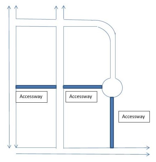
B. The access way shall be in a public right-of-way or a public access easement on private property. The access way may be within a utility easement with the written permission of the utility provider.
C. A pedestrian and bicycle access way shall be a minimum of 15 feet in width. The access way shall have an eight-foot-wide path of concrete, asphalt, brick/masonry pavers, or other city-approved durable surfaces meeting ADA requirements. The remaining width shall be of living or nonliving pervious landscape materials that meet the approval of the planning director.
D. Where constrained by steep slopes, environmentally sensitive areas, historic or culturally significant areas, or existing development, the planning commission may modify the requirement for an access way. (Ord. 2016-21 § 8; Ord. 2011-01 § 1; Ord. 78-32 § 3.010(4)(c))
16.12.210 Lots – General requirements.
The lot size, width, shape and orientation shall be appropriate for the location of the subdivision and for the type of development and use contemplated. (Ord. 2011-01 § 1; Ord. 78-32 § 3.010(5)(a))
16.12.220 Minimum lot sizes.
A. The lot sizes, in addition to conformance with LCMC Title 17, shall be not less than as given in the following table:
|
|
Minimum Size in Feet |
|
|---|---|---|
|
Type of Lot |
Width |
Average Depth |
|
Corner lot |
60 |
80 |
|
Interior lot |
50 |
70 |
|
Through lot with planting screen |
50 |
120 |
B. In the case of irregular lots, the widths measured at a building line must be not less than 70 feet.
C. Where property is zoned and planned for business or industrial use, other widths and areas may be permitted at the discretion of the planning commission. Depth and width of properties reserved or laid out for commercial and industrial purposes shall be adequate to provide for the off-street loading and parking facilities required by the type of use and development contemplated. (Ord. 2011-01 § 1; Ord. 78-32 § 3.010(5)(b))
16.12.230 Through lots.
A. Through lots shall be avoided except where essential to provide separation of residential development from major traffic arteries or adjacent nonresidential activities or to overcome specific disadvantages of topography and orientation.
B. A planting screen easement of at least 10 feet in width and across which there shall be no right of access may be required along the line of lots abutting such a traffic artery or other disadvantageous use. (Ord. 2011-01 § 1; Ord. 78-32 § 3.010(5)(c))
16.12.240 Lot side lines.
The side lines of lots shall run at right angles to the street upon which the lots face. On curved streets they shall be radial to the curve. (Ord. 2011-01 § 1; Ord. 78-32 § 3.010(5)(d))
16.12.250 Lots – Resubdivision.
A. In subdividing or partitioning tracts into large lots which at some future time are likely to be subdivided or partitioned, that resubdivision or partitioning shall take place without violating the requirements of these regulations and without interfering with the orderly development of streets.
B. Restriction of building locations in relationship to future street right-of-way shall be made a matter of record if the planning commission considers it necessary. (Ord. 2011-01 § 1; Ord. 78-32 § 3.010(5)(e))
16.12.260 Lots – Residential building setback lines.
If special building setback lines are to be established in the subdivision or partition, they should be shown on the subdivision or partition plan or included in the deed restriction. (Ord. 2011-01 § 1; Ord. 78-32 § 3.010(5)(f))
16.12.270 Public open spaces.
A. Due consideration shall be given by the subdivider or partitioner to the allocation of suitable areas for schools, parks and playgrounds to be dedicated for public use as per the city comprehensive plan.
B. Where a proposed park, playground, school or other public use shown in a tentative plan is located in whole or in part in a subdivision or partition, the planning commission may request the dedication or reservation of such area within the subdivision or partition in those cases in which the planning commission deems such requirements to be reasonable with the approval of the city council. (Ord. 2011-01 § 1; Ord. 78-32 § 3.010(6))