


Chapter 18.150
TRANSPORTATION IMPROVEMENTS
Sections:
18.150.020 Transportation improvement standards.
18.150.030 Traffic impact analysis standards.
18.150.040 Transportation planning rule compliance.
18.150.050 Criteria for certain transportation facilities and improvements.
18.150.060 Pedestrian access and circulation.
18.150.010 Purpose.
The purpose of this chapter is to provide standards and requirements for transportation improvements and to ensure that such improvements are consistent with the Monmouth Transportation System Plan and Oregon’s Transportation Planning Rule (TPR) (Oregon Administrative Rules (OAR) Chapter 660, Division 12). (Amended by Ord. 1408, § 1 (Exh. A), May 2, 2023. Code 1983 § 96.405.)
18.150.020 Transportation improvement standards.
(1) The location, width, and grade of streets, bikeways and pedestrian facilities shall be considered in their relation to existing and planned streets, bikeways and pedestrian facilities, to topographical conditions, to public convenience and safety, and to the proposed use of the land to be served by the streets. All streets, bikeways, and pedestrian facilities shall connect to other such facilities within the development and to existing and planned streets, bikeways, and pedestrian facilities outside the development. Where location is not shown in the Monmouth Transportation System Plan or another development plan, the arrangement of streets in a subdivision shall either:
(a) Provide for the continuation or appropriate projection of existing and planned streets, bikeways and pedestrian facilities in surrounding areas; or
(b) Conform to a plan for the neighborhood approved or adopted by the Planning Commission to meet a particular situation where topographical or other conditions make continuance or conformance to existing streets, bikeways and pedestrian facilities impractical.
(2) Widths of street rights-of-way and paving design for streets shall be not less than those set forth in the table below, except as follows:
(a) A minor variance has been approved pursuant to MCC 18.20.030(7); or
(b) For a street abutting land not in the subdivision or partition area, a lesser width may be allowed as a variance where the applicant presents a satisfactory plan as to when such street will be expanded to the required width.
(3) The width of street rights-of-way provided in the table in subsection (5) of this section shall be the minimum widths of rights-of-way for streets existing along and adjacent to any boundary of the subdivision or partition which is the natural or planned continuation of the alignment of the existing or proposed streets, and the applicant shall dedicate additional rights-of-way, as determined by the Public Works Director in accordance with such table, for any such adjacent street, proposed for access to the subdivision, where the existing width of rights-of-way for such street is less than the minimum in said table. Off-site improvements, such as pavement construction or reconstruction of existing street(s) proposed for access to the subdivision, which are inadequate or in failing condition, may be required. Off-site transportation improvements will include bicycle and pedestrian improvements, as identified in the adopted City of Monmouth Transportation System Plan.
(4) The standard cross-section for local streets includes on-street parking on both sides of the street, with a total paved cross-section of 36 feet. The Public Works Director will permit development of a local street with a paved cross-section of 28 feet, as a local street alternative design as shown in Table 7-2, if it can be shown that the traffic volume is not anticipated to meet or exceed 400 vehicles per day (average daily link volume) and where the street design limits parking to one side of the street only.
(5) Street Standards.
|
Classification |
Right-of-Way |
Streetscape |
Travel Lanes |
Bike Lanes |
On-Street Parking |
Sidewalks |
Landscaping |
|---|---|---|---|---|---|---|---|
|
Major Arterial1 |
80 feet |
73 feet |
2 travel + center turn lane or median |
6 feet |
No |
6.5 feet |
5 feet |
|
Minor Arterial |
70 feet |
64 feet |
2 travel + center turn lane or median |
6 feet |
No2 |
7 feet |
No |
|
Ash Creek Drive |
80 feet |
64 feet |
2 |
Yes3 |
No2 |
6 feet3 |
6 feet3 |
|
Downtown STA1 |
70 feet |
68 feet |
2 |
5 feet |
8 feet, both sides |
10 feet |
Tree well |
|
Major Collector |
60 feet |
48 feet |
2 |
6 feet |
No2 |
6 feet |
No |
|
Minor Collector |
60 feet |
52 feet4 |
2 |
No |
8 feet, both sides |
6 feet |
No |
|
Local Street |
60 feet |
48 feet |
2, unstriped |
No |
8 feet, both sides |
6 feet |
No |
|
Local Street PUD |
60 feet |
58 feet |
2, unstriped |
No |
8 feet, both sides |
6 feet |
5 feet |
|
Local Street (Alternative) |
52 feet |
40 feet |
2, unstriped |
No |
8 feet, one side |
6 feet |
No |
|
1 Design of all State highways are subject to the design standards and guidelines in the ODOT Highway Design Manual. |
|||||||
|
2 On-street parking can be provided on all City streets at the discretion of the Public Works Director. |
|||||||
|
3 The Ash Creek Drive cross-section includes sidewalk and bike lane on the north side and a multi-use path on the south side, separated from the roadway by a 10-foot-wide natural buffer. |
|||||||
|
4 Curb extensions are encouraged on minor collectors to encourage appropriate travel speeds. |
|||||||
(6) Slope Easements. Slope easements shall be dedicated in accordance with the specifications adopted by the City Council.
(7) Reserve Strips or Block. The Planning Commission may require the land divider to create a reserve block controlling the access to a street, said block to be placed under the jurisdiction of the City Council:
(a) To prevent access to abutting land at the end of a street and to ensure the proper extension of the street pattern and the orderly development of land lying beyond the street.
(b) To prevent access to the side of a street on the side where additional width is required to meet the right-of-way standards provided in the above table.
(c) To prevent access to land abutting a street of the partition or subdivision, but not within the partition or subdivision itself.
(d) To prevent access to land unsuitable for building development.
(8) Alignment. As far as is practical, streets shall be in alignment with existing streets by continuations of the centerlines thereof. Staggered street alignment resulting in “T” intersections shall, wherever practical, leave a minimum distance of 200 feet between the center lines of streets having approximately the same direction and otherwise shall not be less than 125 feet.
(9) Future Extension of Streets. Where the subdivision or partition is adjacent to developable land larger than two acres in size with a frontage of more than 200 feet, streets, bikeways and pedestrian facilities shall be extended to the boundary of the subdivision and the resulting dead-end streets may be approved without a turnaround. Reserve strips or blocks may be required to preserve the objectives of street extensions. For purposes of this section, “developable land” is land that is vacant or underutilized and can be serviced with water and sewer.
(10) Intersections of Streets.
(a) Angles. Streets shall intersect one another at right angles as is practicable considering topography of the area and previous adjacent layout. Where not practicable, the right-of-way and street paving within the acute angle shall have a minimum of 30 feet centerline radius where such angle is not less than 60 degrees. In the case of streets intersecting at an angle of less than 60 degrees, then of such minimum as the Public Works Director designee may determine in accordance with the purpose of MCC 17.05.020.
(b) Offsets. Intersections shall be so designed that no offset dangerous to the traveling public is created as a result of staggering of intersections; and in no case shall there be an offset of less than 125 feet centerline to centerline.
(11) Topography. The layout of streets shall give suitable recognition to surrounding topographical conditions in accordance with the purpose of MCC 17.05.020.
(12) Existing Streets. Whenever existing streets adjacent to or within a tract are of inadequate width, additional right-of-way shall be provided at the time of subdivision.
(13) Half Streets. Half streets, while generally not acceptable, may be approved if at least 33 feet wide, where essential to the reasonable development of the subdivision, when in conformity with the other requirements of these regulations, and when the Planning Commission finds it will be practical to require the dedication of the other half when the adjoining property is subdivided. Whenever a half street is platted within such tract, reserve strips and street plugs may be required to preserve the objectives of half streets.
(14) Cul-de-sac. There shall be no cul-de-sacs more than 200 feet long or serving more than 20 single-family dwellings. Each cul-de-sac shall have a circular end with a minimum diameter of right-of-way width and paving as shown in the table in subsection (5) of this section. The use of cul-de-sacs shall be discouraged and may only be approved upon a showing by the applicant of unusual or unique circumstances justifying the cul-de-sac. For purposes of this section, “unusual or unique circumstances” exist when one of the following conditions prevents a required street connection:
(a) Slopes are equal to or greater than 12 percent;
(b) A wetland or other water body is present that cannot be bridged or crossed; or
(c) Existing development on adjacent property prevents a street connection.
(15) Street Names. Streets that are in alignment with existing named streets shall bear the names of such existing streets. Names for streets that are not in alignment with existing streets are subject to approval by the Planning Commission and shall not unnecessarily duplicate or resemble the name of any existing or platted street in the City.
(16) Grades and Curves. Grades shall not exceed six percent on arterials, 10 percent on collector streets, or 12 percent on all other streets. Centerline radii on curves shall not be less than 300 feet on arterials or 230 feet on all other streets and shall be to an even 10 feet. Where existing conditions, particularly the topography, made it otherwise impractical to provide buildable lots, the Planning Commission may accept steeper grades and sharper curves. In flat areas, allowance shall be made for finished street grades having a minimum slope, preferably, or at least 0.33 percent.
(17) Streets Adjacent to Railroad Rights-of-Way. Wherever the proposed subdivision contains or is adjacent to a railroad right-of-way, provision may be required for a street approximately parallel to and on each side of such right-of-way at a distance suitable for the appropriate use of the land between the streets and the railroad. The distance shall be determined with due consideration at cross streets of the minimum distance required for approach grades to a future grade separation and to provide sufficient depth to allow screen planting along the railroad right-of-way.
(18) Marginal Access Streets. Where a subdivision abuts or contains an existing or proposed arterial street, the Planning Commission may require marginal access streets, reverse frontage lots with suitable depth, screen planting contained in a nonaccess reservation along the rear or side property line, or other treatment necessary for adequate protection of residential properties and to afford separation of through and local traffic.
(19) Alleys. Alleys shall be provided in commercial and industrial districts, unless other provisions for access to off-street parking and loading facilities are approved by the Planning Commission. The corner of alley intersections shall have a radius of not less than 12 feet.
(a) Dedication. The Planning Commission may require adequate and proper alleys to be dedicated to the public by the land divider of such design and in such location as necessary to provide for the access needs of the subdivision or partition in accordance with the purpose of MCC 17.05.020.
(b) Width. Width of right-of-way and paving design for alleys shall be not less than 20 feet. Slope easements shall be dedicated in accordance with specifications adopted by the City Council.
(c) Corner Cut-Offs. Where two alleys intersect, 10-foot corner cut-offs shall be provided.
(d) Grades and Curves. Grades shall not exceed 12 percent on alleys, and centerline radii on curves shall be not less than 100 feet.
(e) Other Requirements. All provisions and requirements with respect to streets in MCC Title 17 shall apply to alleys the same in all respects as if the word “street” or “streets” therein appeared as the word “alley” or “alleys,” respectively.
(20) Access Management. New access to arterials and collectors shall be limited. Shared or consolidated access shall be required for development or land divisions adjacent to these facilities, pursuant to this section, unless demonstrated to be unfeasible.
(a) Access control standards apply to public, industrial, commercial and residential developments including land divisions. Access shall be managed to maintain an adequate level of service and to maintain the functional classification of roadways as required by the City of Monmouth Transportation System Plan. Major roadways, including arterials and collectors, serve as the primary system for moving people and goods within and through the City. Access management is a primary concern on these roads. Local streets and alleys provide access to individual properties. If vehicular access and circulation are not properly designed, these roadways will be unable to accommodate the needs of development and serve their transportation function.
(b) Traffic Impact Analysis Requirements. The City or other agency with access jurisdiction may require a traffic study prepared by a qualified professional to determine access, circulation and other transportation requirements. (See also MCC 18.150.030, Traffic impact analysis standards.)
(c) The City or other agency with access permit jurisdiction may require the closing or consolidation of existing curb cuts or other vehicle access points, recording of reciprocal access easements (i.e., for shared driveways), development of a frontage street, installation of traffic control devices, and/or other mitigation as a condition of granting an access permit, to ensure the safe and efficient operation of the street and highway system. Access to and from off-street parking areas shall not permit backing onto a public street.
(d) Access Options. When vehicle access is required for development (i.e., for off-street parking, delivery, service, drive-through facilities, etc.), access shall be provided by one of the following methods (planned access shall be consistent with adopted public works standards for road construction). These methods are “options” to the developer/subdivider.
(i) Option 1. Access is from an existing or proposed alley or mid-block lane. If a property has access to an alley or lane, direct access to a public street is not permitted.
(ii) Option 2. Access is from a private street or driveway connected to an adjoining property that has direct access to a public street (i.e., “shared driveway”). A public access easement covering the driveway shall be recorded in this case to assure access to the closest public street for all users of the private street/drive.
(iii) Option 3. Access is from a public street adjacent to the development parcel. If practicable, the owner/developer may be required to close or consolidate an existing access point as a condition of approving a new access. Street accesses shall comply with the access spacing standards in subsection (20)(e) of this section.
(e) Access Spacing and Driveway Width. All proposed development shall have access to a public right-of-way. Spacing and driveway width requirements for access points and intersections on arterials and collector streets shall be as shown in the following three tables:
|
Posted Speed |
Spacing Standards1 |
Spacing Standards for STA |
|---|---|---|
|
OR 99W – Regional Highway |
||
|
50 mph |
830 feet |
N/A |
|
40 and 45 mph |
750 feet |
N/A |
|
30 and 35 mph |
425 feet |
N/A |
|
≤ 25 mph |
350 feet |
N/A |
|
OR 51 – District Highway |
||
|
50 mph |
550 feet |
N/A |
|
40 and 45 mph |
500 feet |
N/A |
|
30 and 35 mph |
350 feet |
175 feet or mid-block2 |
|
≤ 25 mph |
350 feet |
175 feet or mid-block2 |
|
Note: Spacing standards obtained from the Oregon Highway Plan (OHP). Consult the OHP for updates and addenda. |
||
|
1 Measurement of the approach road spacing is from the center on the same side of the roadway. |
||
|
2 Per the OHP, driveways are discouraged in STAs. However, “where driveways are allowed and where land use patterns permit, the minimum access management spacing for driveways is 175 feet or mid-block if the current block is less than 350 feet.” |
||
|
Functional Classification |
Public Street |
Private Access Drive (feet) |
|---|---|---|
|
Local Street |
150 feet |
50 feet |
|
Minor Collector |
300 feet |
50 feet |
|
Major Collector |
300 feet |
100 feet |
|
Ash Creek Drive |
300 feet |
150 feet |
|
Minor Arterial |
350 feet or block length |
200 feet or mid-block |
|
Major Arterial1 |
350 feet or block length |
350 feet or block length |
|
1 Access standards identified in the Oregon Highway Plan supersede this table on all State highways. |
||
|
Land Use |
Minimum |
Maximum |
|---|---|---|
|
Single-Family Residential |
12 feet |
24 feet |
|
Multifamily Residential |
24 feet |
30 feet |
|
Commercial |
30 feet |
40 feet |
|
Industrial |
30 feet |
40 feet |
(f) The distance between access points shall be measured from the centerline of the proposed driveway or roadway to the centerline of the nearest adjacent roadway or driveway.
(g) Projects proposed on arterials shall include a frontage or service road and shall take access from the frontage road rather than the arterial. Frontage road design shall conform to ODOT standards. This access requirement may be met through the use of interconnecting parking lots that abut the arterial.
(h) Alternative Designs. Where unique site characteristics, such as natural features or spacing of existing driveways and roadways, cause the local (nonhighway) access requirements to be physically unfeasible, alternate designs may be approved.
(i) Subdivisions Fronting onto an Arterial Street. New residential land divisions fronting onto an arterial street shall be required to provide alleys or secondary (local or collector) streets for access to individual lots. When alleys or secondary streets cannot be constructed due to topographic or other physical constraints, access may be provided by consolidating driveways for clusters of two or more lots (e.g., includes flag lots and mid-block lanes).
(j) Double-Frontage Lots. When a lot has frontage onto two or more streets, access shall be provided first from the street with the lowest classification. For example, access shall be provided from a local street before a collector or arterial street.
(k) Number of Access Points. For single-family (detached and attached), two-family, and three-family housing types, one street access point is permitted per lot, when alley access cannot otherwise be provided; except that two access points may be permitted for two-family and three-family housing on corner lots (i.e., no more than one access per street), subject to the access spacing standards in subsection (20)(e) of this section. The number of street access points for multiple-family, commercial, industrial, and public/institutional developments shall be minimized to protect the function, safety and operation of the street(s) and sidewalk(s) for all users. Shared access may be required, in conformance with subsection (20)(l) of this section, in order to maintain the required access spacing and minimize the number of access points.
(l) Shared Driveways. The number of driveway and private street intersections with public streets shall be minimized by the use of shared driveways with adjoining lots where feasible. The City shall require shared driveways as a condition of land division or site design review, as applicable, for traffic safety and access management purposes in accordance with the following standards:
(i) Shared driveways and frontage streets may be required to consolidate access onto a collector or arterial street. When shared driveways or frontage streets are required, they shall be stubbed to adjacent developable parcels to indicate future extension. “Stub” means that a driveway or street temporarily ends at the property line, but may be extended in the future, as the adjacent parcel develops. “Developable” means that a parcel is either vacant or it is likely to receive additional development (i.e., due to infill or redevelopment potential).
(ii) Access easements (i.e., for the benefit of affected properties) shall be recorded for all shared driveways, including pathways, at the time of final plat approval or as a condition of site development approval.
(iii) Exception. Shared driveways are not required when existing development patterns or physical constraints (e.g., topography, parcel configuration, and similar conditions) prevent extending the street/driveway in the future.
(21) Bicycle Requirements. Bike lanes shall be provided during the construction, reconstruction, or relocation of arterial and collector streets. Design and construction of bikeways or other public paths shall conform to the requirements of the American Association of State Highway and Transportation Officials (AASHTO) as revised and adopted in the “Oregon Bicycle and Pedestrian Plan.”
(22) Pedestrian Requirements.
(a) Sidewalks shall be constructed along all arterial, collector, and local streets.
(b) The design and construction of sidewalks and other public paths shall conform to the requirements of the “Oregon Bicycle and Pedestrian Plan,” Americans with Disabilities Act (ADA) requirements, and City of Monmouth standards.
(23) Accessways or Multi-Use Paths. Where required:
(a) Accessways or multi-use paths shall be located to provide a reasonably direct connection between likely pedestrian and cyclist destinations. A reasonably direct connection is a route which minimizes out-of-direction travel for most of the people likely to use the multi-use path considering terrain, safety, and likely destinations.
(b) The design and construction of accessways shall conform to the requirements of the “Oregon Bicycle and Pedestrian Plan,” ADA requirements, and City of Monmouth standards.
(24) Lighting. Illumination of all sidewalks and bicycle paths will be provided in conjunction with all new development. Adequacy of the lighting plan will be consistent with AASHTO standards and approved by the Public Works Director. (Amended by Ord. 1352, § 1 (Exh. A), December 2, 2014; Ord. 1408, § 1 (Exh. A), May 2, 2023. Code 1983 § 96.410.)
18.150.030 Traffic impact analysis standards.
(1) Purpose. The purpose of this section of the code is to implement Section 660-012-0045(2)(e) of the State Transportation Planning Rule that requires the City to adopt a process to apply conditions to development proposals in order to minimize adverse impacts to and protect transportation facilities. This section establishes the standards for when a proposal must be reviewed for potential traffic impacts; when a traffic impact analysis must be submitted with a land use or development application in order to determine whether conditions are needed to minimize impacts to and protect transportation facilities; what must be in a traffic impact analysis; and who is qualified to prepare the analysis.
(2) Typical Average Daily Trips. The Trip Generation Manual, Ninth Edition, published by the Institute of Transportation Engineers (ITE), shall be used as the standard by which to gauge average daily vehicle trips.
(3) When Required. A traffic impact analysis may be required by the Public Works Director with a land use or development application when the application involves one or more of the following actions:
(a) A change in zoning or a Comprehensive Plan Map designation;
(b) Any proposed development or land use action that ODOT states may have operational or safety concerns along a State highway; or
(c) The development will cause one or more of the following effects, which can be determined by field counts, site observation, traffic impact analysis or study, field measurements, crash history, Institute of Transportation Engineers Trip Generation Manual, and information and studies provided by the local reviewing jurisdiction and/or ODOT:
(i) An increase in site traffic volume generation by 250 average daily trips (ADT) or more (or as required by the Public Works Director); or
(ii) An increase in site traffic volume generation of 25 or more peak-hour trips; or
(iii) An increase in use of adjacent streets by vehicles exceeding the 20,000 pound gross vehicle weights by 10 vehicles or more per day; or
(iv) The location of the access driveway does not meet minimum intersection sight distance requirements, or is located where vehicles entering or leaving the property are restricted, or such vehicles queue or hesitate, creating a safety hazard; or
(v) The location of the access driveway does not meet the access spacing standard of the roadway on which the driveway is located; or
(vi) A change in internal traffic patterns that may cause safety problems, such as backup onto the highway or a local arterial or collector, or traffic crashes in the approach area.
(4) Traffic Impact Analysis Requirements.
(a) Preparation. A traffic impact analysis shall be prepared by a professional engineer. The City shall commission the traffic analysis and it will be paid for by the applicant.
(b) Transportation Planning Rule Compliance. See MCC 18.150.040, Transportation planning rule compliance.
(c) Preapplication Conference. The applicant will meet with the Public Works Director prior to submitting an application that requires a traffic impact analysis. This meeting will determine the required elements of the TIA and the level of analysis expected.
(5) Approval Criteria. When a traffic impact analysis is required, approval of the development proposal requires satisfaction of the following criteria:
(a) The traffic impact analysis must be prepared by a professional engineer; and
(b) If the proposed development will cause one or more of the effects in subsection (3)(c) of this section, or other traffic hazard or negative impact to a transportation facility, the traffic impact analysis must include mitigation measures that meet the City’s level of service and are satisfactory to the Public Works Director, and ODOT, when applicable; and
(c) The proposed site design and traffic and circulation design and facilities, for all transportation modes, including any mitigation measures, must be designed to:
(i) Have the least negative impact on all applicable transportation facilities;
(ii) Accommodate and encourage non-motor vehicular modes of transportation to the extent practicable;
(iii) Make the most efficient use of land and public facilities as practicable;
(iv) Provide the most direct, safe and convenient routes practicable between on-site destinations, and between on-site and off-site destinations; and
(v) Otherwise comply with applicable requirements of the City of Monmouth Zoning Ordinance.
(6) Study Area. The study area for the TIA shall include, at a minimum, all site-access points and intersections (signalized and unsignalized) adjacent to the proposed site. If the proposed site fronts an arterial or collector street, the study shall include all intersections along the site frontage and within the access spacing distances extending out from the boundary of the site frontage. Beyond the minimum study area, the transportation impact analysis shall evaluate all intersections that receive site-generated trips that comprise at least 10 percent or more of the total intersection volume. In addition to these requirements, the Public Works Director (or his/her designee) shall determine any additional intersections or roadway links that might be adversely affected as a result of the proposed development. The applicant and the Public Works Director (or his/her designee) must agree on these intersections prior to the start of the transportation impact analysis.
(7) Conditions of Approval. As part of every land use action, the City of Monmouth, Polk County (if access to a County roadway is proposed), and ODOT (if access to a State roadway is proposed) may identify conditions of approval needed to meet operations and safety standards and provide the necessary right-of-way and improvements to develop the future planned transportation system. The City may deny, approve, or approve the proposal with appropriate conditions. Conditions of approval that should be evaluated as part of subdivision and site plan reviews include:
(a) Crossover easement agreements for all adjoining parcels to facilitate future access between parcels.
(b) Conditional access permits for new developments, which have proposed access points that do not meet the designated access spacing policy and/or have the ability to align with opposing access driveways.
(c) Right-of-way dedications for future planned roadway improvements.
(d) Half-street improvements along site frontages that do not have full-buildout improvements in place at the time of development. (Amended by Ord. 1320, § 1 (Exh. A), June 18, 2013. Code 1983 § 96.415.)
18.150.040 Transportation planning rule compliance.
(1) Review of Applications for Effect on Transportation Facilities. When a land use or development application, whether initiated by the City or by a private interest, includes a proposed Comprehensive Plan amendment, zone change, or land use regulation change, the proposal shall be reviewed to determine whether it significantly affects a transportation facility, in accordance with Oregon Administrative Rule (OAR) 660-012-0060 (the Transportation Planning Rule – “TPR”). “Significant” means the proposal would:
(a) Change the functional classification of an existing or planned transportation facility (exclusive of correction of map errors in an adopted plan);
(b) Change standards implementing a functional classification system; or
(c) As measured at the end of the planning period identified in the adopted transportation system plan:
(i) Allow land uses or levels of development that would result in types or levels of travel or access that are inconsistent with the functional classification of an existing or planned transportation facility;
(ii) Reduce the performance of an existing or planned transportation facility below the minimum acceptable performance standard identified in the TSP or Comprehensive Plan; or
(iii) Worsen the performance of an existing or planned transportation facility that is otherwise projected to perform below the minimum acceptable performance standard identified in the TSP or Comprehensive Plan.
(2) Amendments That Affect Transportation Facilities. Amendments to the Comprehensive Plan, zoning, and land use regulations that significantly affect a transportation facility shall ensure that allowed land uses are consistent with the function, capacity, and level of service of the facility identified in the TSP. This shall be accomplished by one or a combination of the following:
(a) Adopting measures that demonstrate allowed land uses are consistent with the planned function, capacity, and performance standards of the transportation facility.
(b) Amending the TSP or Comprehensive Plan to provide transportation facilities, improvements or services adequate to support the proposed land uses consistent with the requirements of Section 660-012-0060 of the TPR.
(c) Altering land use designations, densities, or design requirements to reduce demand for automobile travel and meet travel needs through other modes of transportation.
(d) Amending the TSP to modify the planned function, capacity, or performance standards of the transportation facility.
(3) Traffic Impact Analysis. A traffic impact analysis may be required by the Public Works Director for a Comprehensive Plan amendment or change in zoning designation. (See MCC 18.150.030, Traffic impact analysis standards.) (Code 1983 § 96.420.)
18.150.050 Criteria for certain transportation facilities and improvements.
(1) Construction, reconstruction, or widening of highways, roads, bridges or other transportation facilities that are either not designated in the adopted City of Monmouth Transportation System Plan (“TSP”) or not designed and constructed as part of an approved, active, development order are allowed in all zoning districts subject to the conditional use provisions of the Zoning Ordinance and satisfaction of all of the following criteria:
(a) The project and its design are consistent with Monmouth’s adopted TSP and consistent with the State Transportation Planning Rule, OAR 660-012-0060 (“the TPR”).
(b) The project design is compatible with abutting land uses in regard to noise generation and public safety and is consistent with the applicable zoning and development standards and criteria for the abutting properties.
(c) The project design minimizes environmental impacts to identified wetlands, wildlife habitat, air and water quality, cultural resources, and scenic qualities, and a site with fewer environmental impacts is not reasonably available.
(d) The project preserves or improves the safety and function of the facility through access management, traffic calming, or other design features.
(e) The project includes provisions for bicycle and pedestrian access and circulation consistent with the Comprehensive Plan, the requirements of this title, and the TSP.
(2) State Transportation System Facility or Improvement Projects. The Oregon Department of Transportation (“ODOT”) shall provide a narrative statement with the application demonstrating compliance with all of the criteria and standards in subsections (1)(a) through (e) of this section. Where applicable, an environmental impact statement or environmental assessment may be used to address one or more of these criteria.
(3) Proposal Inconsistent with TSP/TPR. If the City determines that the proposed use or activity or its design is inconsistent with the TSP or TPR, then the applicant shall apply for and obtain a plan and/or zoning amendment prior to or in conjunction with conditional use permit approval. The applicant shall choose one of the following options:
(a) If the City’s determination of inconsistency is made prior to a final decision on the conditional use permit application, the applicant shall withdraw the conditional use application; or
(b) If the City’s determination of inconsistency is made prior to a final decision on the conditional use permit application, the applicant shall withdraw the conditional use permit application, apply for a plan/zone amendment, and reapply for a conditional use permit if and when the amendment is approved; or
(c) If the City’s determination of inconsistency is made prior to a final decision on the conditional use permit application, the applicant shall submit a plan/zoning amendment application for joint review and decision with the conditional use permit application, along with a written waiver of the ORS 227.178 120-day period within which to complete all local reviews and appeals once the application is deemed complete; or
(d) If the City’s determination of inconsistency is part of a final decision on the conditional use permit application, the applicant shall submit a new conditional use permit application, along with a plan/zoning amendment application for joint review and decision, as a condition of approval of the conditional use permit application. (MCC 18.150.010 through 18.150.050 added by Ord. 1275, June 16, 2009; amended by Ord. 1320, § 1 (Exh. A), June 18, 2013. Code 1983 § 96.425.)
18.150.060 Pedestrian access and circulation.
(1) Site Layout and Design. To ensure safe, direct, and convenient pedestrian circulation, all mixed use, commercial, and office developments shall provide a continuous pedestrian system. Multidwelling development that proposes 10 or more units in a single building, or that includes two or more buildings, shall also provide a continuous pedestrian system. The pedestrian system shall be based on the standards in subsections (1)(a) through (c) of this section:
(a) Continuous Walkway System. The pedestrian walkway system shall extend throughout the development site, connect to all future phases of development, and to existing or planned off-site adjacent trails, public parks, and open space areas to the greatest extent practicable. The developer may also be required to connect or stub walkway(s) to adjacent streets and to private property with a previously reserved public access easement for this purpose, in accordance with the provisions of MCC 18.150.020, Transportation improvement standards.
(b) Safe, Direct, and Convenient. Walkways within developments shall provide safe, reasonably direct, and convenient connections between primary building entrances and all adjacent streets, based on the following definitions:
(i) Reasonably Direct. A route that does not deviate unnecessarily from a straight line or a route that does not involve a significant amount of out-of-direction travel for likely users.
(ii) Safe and Convenient. Routes that are reasonably free from hazards and provide a reasonably direct route of travel between destinations.
(iii) “Primary entrance” for commercial, mixed use, and office buildings is the main public entrance to the building. In the case where no public entrance exists, street connections shall be provided to the main employee entrance.
(iv) “Primary entrance” for residential buildings is the front door (i.e., facing the street). For multidwelling buildings in which each unit does not have its own exterior entrance, the primary entrance may be a lobby, courtyard, or breezeway which serves as a common entrance for more than one dwelling.
(c) Connections Within Development. Connections within developments shall be provided as required in subsections (1)(c)(i) through (iii) of this section:
(i) Walkways shall connect all building entrances to one another to the extent practicable, as generally shown in Figure 18.150.060-1;
(ii) Walkways shall connect all on-site parking areas, storage areas, recreational facilities, and common areas and shall connect off-site adjacent uses to the site to the extent practicable. Topographic or existing development constraints may be cause for not making certain walkway connections, as generally shown in Figure 18.150.060-1; and
(iii) Large parking areas shall be broken up so that no contiguous parking area exceeds three acres. Parking areas may be broken up with plazas, large landscape areas with pedestrian accessways (i.e., at least 20 feet total width), streets, or driveways with street-like features. “Street-like features,” for the purpose of this section, means a raised sidewalk of at least four feet in width, six-inch curb, accessible curb ramps, street trees in planter strips or tree wells, and pedestrian-oriented lighting.
Figure 18.150.060-1 Pedestrian Pathway System (Typical)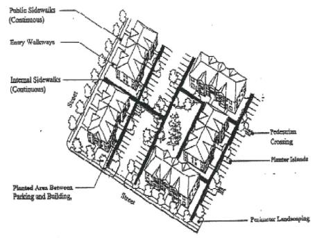
(2) Walkway Design and Construction. Walkways, including those provided with pedestrian accessways, shall conform to all of the standards in subsections (2)(a) through (d) of this section, as generally illustrated in Figure 18.150.060-2:
Figure 18.150.060-2 Pedestrian Walkway Detail (Typical)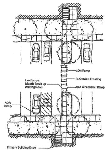
(a) Vehicle/Walkway Separation. Except for crosswalks (subsection (2)(b) of this section), where a walkway abuts a driveway or street it shall be raised six inches and curbed along the edge of the driveway/street. Alternatively, the City may approve a walkway abutting a driveway at the same grade as the driveway if the walkway is protected from all vehicle maneuvering areas. An example of such protection is a row of decorative metal or concrete bollards designed for withstanding a vehicle’s impact, with adequate minimum spacing between them to protect pedestrians.
(b) Crosswalks. Where walkways cross a parking area, driveway, or street (“crosswalk”), they shall be clearly marked with contrasting paving materials (e.g., light-color concrete inlay between asphalt), which may be part of a raised/hump crossing area. Painted or thermoplastic striping and similar types of nonpermanent applications may be approved for crosswalks not exceeding 24 feet in length.
(c) Walkway Width and Surface. Walkway and accessway surfaces shall be concrete, asphalt, brick/masonry pavers, or other durable surface, as approved by the Public Works Director, at least six feet wide. Multi-use paths (i.e., for bicycles and pedestrians) shall be concrete or asphalt, at least 10 feet wide.
(d) Accessible Routes. Walkways shall comply with applicable Americans with Disabilities Act (ADA) requirements. The ends of all raised walkways, where the walkway intersects a driveway or street, shall provide ramps that are ADA accessible, and walkways shall provide direct routes to primary building entrances. (Ord. 1408, § 1 (Exh. A), May 2, 2023.)