


CHAPTER 5
OVERLAY DISTRICT REGULATIONS
Sections:
Article 1 – FLOODPLAIN OVERLAY REGULATIONS
Article 2 – HISTORIC DISTRICT OVERLAY REGULATIONS
11-5-202 New Construction Subject to Design Standards.
Article 3 – HILLSIDE OVERLAY REGULATIONS
11-5-301 Hillside Overlay Regulations.
11-5-303 Lot Area Requirements.
11-5-304 Lot and Building Configurations.
Article 4 – WESTFIELDS AND LAKESIDE OVERLAY REGULATIONS
11-5-402 Use and Development Regulations.
11-5-403 Density Determination.
11-5-404 Minimum Performance Standards.
11-5-405 Bonuses for Maximum Density.
11-5-406 Housing Mix Requirements.
11-5-408 Submission and Approval Process.
11-5-409 Final Plat Recordation.
11-5-410 Covenants, Conditions & Restrictions (CC&Rs).
11-5-411 Amendments to the Plan or Recorded Plat.
11-5-412 Construction Requirements.
Article 5 – WESTFIELDS OVERLAY – VILLAGE CENTER ZONE
11-5-504 Design Standards for Mixed-Use Sections of the Village Center.
11-5-506 Density Standards for the Mixed-Use Section of the Village Center.
11-5-507 Density and Design Standards for Multi-Family Section of the Village Center.
11-5-508 Design Standards for the Multi-Family Section of the Village Center.
Article 6 – MIXED USE OVERLAY REGULATIONS
11-5-602 General Requirements.
11-5-603 Development Standards.
11-5-605 Submission and Approval Process.
Article 7 – MATERIALS PROCESSING AND STORAGE OVERLAY REGULATIONS
11-5-704 Location Requirements.
11-5-706 Business License Regulations.
11-5-707 Operational Regulations.
Article 8 – TRADITIONAL NEIGHBORHOOD DEVELOPMENT (TND) OVERLAY ZONE
11-5-803 TND Overlay Zone Application.
11-5-804 New Neighborhood Plans.
11-5-805 Requirements for New Neighborhood Plan Elements.
Article 1 – FLOODPLAIN OVERLAY REGULATIONS
11-5-101 [Repealed]
(Repealed by Ord. No. 12-2020, 06/02/2020)
11-5-102 [Repealed]
(Repealed by Ord. No. 12-2020, 06/02/2020)
11-5-103 [Repealed]
(Repealed by Ord. No. 12-2020, 06/02/2020)
11-5-104 [Repealed]
(Repealed by Ord. No. 12-2020, 06/02/2020)
11-5-105 [Repealed]
(Repealed by Ord. No. 12-2020, 06/02/2020)
11-5-106 [Repealed]
(Repealed by Ord. No. 12-2020, 06/02/2020)
11-5-107 [Repealed]
(Repealed by Ord. No. 12-2020, 06/02/2020)
11-5-108 [Repealed]
(Repealed by Ord. No. 12-2020, 06/02/2020)
11-5-109 [Repealed]
(Repealed by Ord. No. 12-2020, 06/02/2020)
Article 2 – HISTORIC DISTRICT OVERLAY REGULATIONS
11-5-201 Purpose and Intent.
The purpose of the Springville Historic District Overlay Zone, as identified on the Official Zoning Map, is to carry out the adopted policies of Springville City and to protect the historic integrity of the area by ensuring that new development complements the existing structures in design, materials and building siting.
(Ord. No. 08-2008, 05/20/2008)
11-5-202 New Construction Subject to Design Standards.
All new development in the Springville Historic District Overlay Zone shall be subject to the requirements of any and all adopted design standards for the district.
(Ord. No. 08-2008, 05/20/2008)
Article 3 – HILLSIDE OVERLAY REGULATIONS
11-5-301 Hillside Overlay Regulations.
The Hillside Overlay Zone covers the mountainous and other areas in the City of environmental concern. Because of topography, slope, soil conditions and other natural features, the area is considered to be environmentally fragile, and all developed activity occurring in the area should be carried out in a manner consistent with these natural limitations. It is hereby declared that the purpose and intent in establishing the Hillside Overlay Zone is to:
(1) Protect and conserve the soils, natural vegetation, and drainage ways and other natural resources within the area.
(2) Avoid the establishment of hazard from flood, fire, mud slide, and other dangers.
(3) Preserve the aesthetic appearance of the landscape and prevent excessive degradation of the environment.
(4) Permit certain types of development to take place under such conditions as will result in the substantial preservation of the natural features within the zone.
(5) Secure economy in governmental expenditures.
11-5-302 Permitted Uses.
Permitted uses within the Hillside Overlay Zone shall include all uses permitted within the underlying zone subject to compliance with all requirements for development in hillside areas as set forth in this Article or elsewhere in this Code or in specifications and regulations adopted pursuant hereto.
11-5-303 Lot Area Requirements.
The minimum lot area in the Hillside Overlay Zone is twenty thousand (20,000) square feet regardless of the underlying zone requirement.
11-5-304 Lot and Building Configurations.
Width and location requirements of a zoning lot in the Hillside Overlay Zone shall be that of the underlying zone.
11-5-305 Special Provisions.
All uses of land in the Hillside Overlay Zone shall conform to the following criteria:
(1) All land surface having a slope of twenty-five percent (25%) or greater shall remain in its natural state and shall not be graded or otherwise disturbed, except that the natural vegetation may be supplemented by other plants naturally occurring in the area; provided, however, roads may be constructed on slopes exceeding twenty-five percent (25%) if the following requirements are met:
(a) The road has been approved and is either an existing City street or detailed plans showing the precise location and engineering detail have been submitted and approved by the City Council after recommendation of the Planning Commission.
(b) The Planning Commission and City Council have determined that the proposed alignment is necessary for the proper development of the area and that there is no feasible alternate alignment which complies with the slope requirement.
(c) The plan provides adequate measures to insure that all cut and fill slopes will be stabilized, that erosion hazards will be eliminated, that surface vegetation will be restored, and that other environmental hazards will be adequately handled.
(2) Each dwelling site shall contain a buildable area of not less than four thousand (4,000) square feet.
(3) No cut or fill slope that shall be created as a part of the construction of any roadway, dwelling, or other structure shall exceed the critical angle of repose, except by special permission of the City Council after recommendation of the Planning Commission. Such special permission shall not be given until the developer shows that he has adopted all practical measures to reduce the slopes to less than the critical angle of repose by selecting an alternate location, or by planting the slopes with natural vegetation, or by undertaking other action which will have the effect of preventing the soil from moving under the force of gravity until vegetation becomes established.
(4) All development shall provide to the satisfaction of the Planning Commission for the disposal of surface water originating as a result of any modification in the environment. Provision shall also be made to the satisfaction of the Planning Commission for the accommodation of all storm water run-off arising on or above the site so as to prevent flooding or erosion.
(5) If it determines it to be necessary in order to adequately evaluate any proposed development in the Hillside Overlay Zone, the Planning Commission may require an environmental impact statement containing the information specified in Section 11-6-128 and a geologic report containing the information specified in Section 11-6-129.
(6) No grading, filling, or excavation of any kind shall be commenced without first obtaining a grading permit as required by Chapter 6 of Title 10 of this Code. In issuing any such permit, the Building Official may, as a condition of the permit, require the person doing the grading, filling or excavation to do such work in the manner specified by the permit in order to:
(a) Encourage only minimal grading which relates to the natural contour of the land and which will round off, in a natural manner, sharp angles at the top and ends of cuts and fill slopes;
(b) Retain trees and other vegetation which stabilize steep hillsides, retain moisture, prevent erosion, enhance the natural scenic view, and where necessary install additional landscaping to enhance the scenic and safety qualities of the area;
(c) Provide for immediate planting wherever appropriate to maintain necessary cut and fill slopes, to stabilize such areas with plant roots, to conceal raw soil from view, and to minimize erosion;
(d) Preserve natural drainage channels;
(e) Encourage retention of natural landmarks and prominent natural features, wildlife habitat, and open space;
(f) Preserve and enhance the visual and environmental quality of the area through the use of natural vegetation and prohibition of excessive excavation and terracing;
(g) Protect the public from natural hazards of run-off water and erosion by requiring drainage facilities.
(7) As a means of harmonizing development within the project with existing and planned development within the surrounding area, the Planning Commission may, as a condition of its approval, specify or may require changes in the density, minimum and maximum height of buildings and structures, and type and style of architecture, the character and nature of landscaping, the pattern of circulation, the location and siting of buildings, fences, walls, utilities, lighting and sprinkling facilities, and other structures, as well as the nature and extent of drainage facilities.
(8) No dwelling or other structure used for human habitation shall be constructed on fill material, unless such material shall have been compacted as directed by the City Engineer. All fill in the Hillside Overlay Zone shall be compacted to at least ninety-five percent (95%) of American Association of State Highway Transportation Officials T180 density for those areas intended as structural foundations, including roadways.
Article 4 – WESTFIELDS AND LAKESIDE OVERLAY REGULATIONS
11-5-401 Purpose and Intent.
The purpose of the Westfields and Lakeside Overlay Zones is to carry out the adopted policies of Springville City concerning the Westfields and Lakeside communities. This will help create attractive, diverse neighborhoods including a wide variety of attached and detached quality housing, along with opportunities for shopping and services all within reasonable walking distance for the majority of area residents.
(1) This purpose can be achieved by:
(a) Providing a network of connected streets and paths that will provide adequate circulation for both pedestrians and vehicles and encourage a less auto-dependent community;
(b) Providing a broad range of housing including suburban residences to urban-type apartments and townhouses throughout the area;
(c) Providing significant open space, consisting of formal parks located throughout the residential area and squares located in the village center, along with a network of trails adjacent to waterways and the power corridor; and
(d) Developing streets that balance the needs of vehicles, pedestrians and residents.
(2) Examples of architectural features and building siting specifically identified as being desirable are found in some sections of Springville’s Plat A neighborhoods, which may serve as a source of concepts and ideas to emulate. Neighborhoods should be created that are long-term assets to future generations of Springville. Considerations for creating quality, functional neighborhoods include, but are not limited to:
(a) Similar residential densities generally facing each other across the street and the rear of the lots acting as the boundaries between different densities of housing and types of uses.
(b) Higher density developments mixed with single-family detached housing should generally be located near park space or on the edges of the neighborhood.
(c) Larger two (2) story houses or twin homes should generally be located on corner lots.
(d) Front facades should run parallel to the street.
(e) Well-defined front entries and attractive porches.
(f) Recessed or detached garages, located behind the front setback line.
(g) Recessed or detached garages that are not major focal points of houses when viewed from the street and are located behind the front setback line.
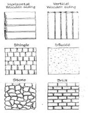
(h) Use of traditional building materials, specifically brick.
(i) Use of same material on all facades of the building.
(j) Use of heavier materials (e.g., brick and stone) on the bottom of the facade, with lighter materials on the top (e.g., stucco or siding).
(k) Use of heavier materials on the primary facades with lighter materials on projections or relief features.
(l) Darker colors on the bottom of the facade with lighter colors on the top.
(m) Vertical orientation of primary windows.
(n) Symmetrical placement of window within the bay of the facade.
(o) Use of mullions and muntins to break up large expanses of glass, creates a vertical emphasis of windows.
(p) Window treatments should either be recessed, trimmed or project from the exterior wall to provide variation in the facade. Window sills and window heads are also encouraged.
(q) Tree lined streets with adequately sized park strips.
(r) Roof pitches appropriate to the style, typically greater than five to twelve (5:12).
(Ord. No. 16-2016 § 1, 07/05/2016)
11-5-402 Use and Development Regulations.
Uses in the Westfields and Lakeside Overlays are limited to the permitted, conditional and accessory uses in the underlying zone for those developments not participating in the density bonus program. For developments participating in the density bonus program, attached dwelling units will be allowed in accordance with the requirements of the density bonus program.
Each portion of the development must correspond to an existing zoning designation adopted by Springville City, for the purpose of meeting the residential site development standards, and that designation must be indicated on the plat or site plan submission. The indicated designations do not change the underlying zone. The R1-5 zone designation is only allowed in the Lakeside Overlay and shall not be allowed in the Westfields Overlay.
(Ord. No. 16-2016 § 1, 07/05/2016; Ord. No. 03-2017 § 3, 03/21/2017; Ord. No. 15-2019 § 3, 07/02/2019)
11-5-403 Density Determination.
The following are the baseline numbers establishing densities for each residential zone:
|
Zoning District |
Baseline Units/Acre |
|---|---|
|
R-1-15 |
2.0 |
|
R-1-10 |
3.0 |
|
R-1-8 |
3.8 |
|
R-2 |
6.0 |
|
RMF-1 |
7.7 |
|
RMF-2 |
11.5 |
The table above is based on the gross developable acreage of the entire proposed development. The baseline units per acre number in the above table shall serve as the maximum number of units allowed in any development not participating in the density bonus program and shall serve as the baseline number from which densities will be calculated for developments that are in the density bonus program.
The area of nonresidential uses in a proposed development, except for parks and open spaces, will be excluded from the gross developable acreage when determining the baseline numbers as per the table above.
(Ord. No. 12-05, 06/07/2005; Ord. No. 16-2016 § 1, 07/05/2016; Ord. No. 03-2017 § 4, 03/21/2017)
11-5-404 Minimum Performance Standards.
(1) The following are minimum standards for single-family detached dwellings, twin homes or duplexes developed in the Westfields and Lakeside Overlays:
(a) The same elevation may not be used on the adjacent two (2) lots on either side of the subject property or the five (5) lots across the street from the subject property on any block length, as illustrated below. 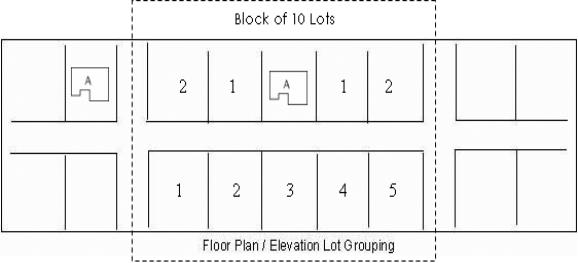
(b) No garage shall occupy more than forty percent (40%) of the total building frontage. This measurement does not apply to garages facing on a carriageway, or set back at least twenty feet (20') from the front of the house or that are side loaded.
(c) In any lot with street frontage of sixty feet (60') or less that includes a carriageway, all required parking shall be accessed from the carriageway. The required parking shall be set back a minimum of five feet (5') from the rear property line.
(d) Front loaded garages on lots with street frontage of sixty feet (60') or less must be set back a minimum of twenty feet (20') from the required front setback of the house.
(e) Single-family detached houses may have a roof pitch of no less than five to twelve (5:12).
(f) All walls which face a public street must contain at least twenty-five percent (25%) of the wall space in windows or doors. However, on homes that have sideloaded garages, all walls which face a public street must contain at least twenty percent (20%) of the wall space in windows or doors.
(g) Primary entrances shall face the public street and sidewalk.
(h) Windows shall not be flush with exterior walls. They shall be recessed or treated with a trim.
(i) Building materials shall be applied in consistent amounts on the front and side wall elevations of houses on interior lots and all wall elevations of the houses on corner lots. In no case shall the percentage of building materials vary greater than ten percent (10%) on those elevations where consistent amounts are required.
(2) The following are minimum standards for any multiple-unit residential buildings and lots, either for rental or ownership, developed in the Westfields and Lakeside Overlays:
(a) Parking for all multi-family dwelling units (excluding row houses in the Lakeside Overlay) shall be located behind the principal building and may be accessed from a carriageway or driveway. Parking for row house units in the Lakeside Overlay may include a maximum of forty percent (40%) of the overall units within the development to include front loaded garages that are flush or recessed from the front wall.
(b) Primary entries shall face a public street. 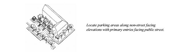
(c) At least fifty percent (50%) of the block length shall have building facades within thirty feet (30') of the front property line.
(d) All front facades must include twenty-five percent (25%) of the wall space in windows or doors.
(e) The use of materials must be consistent on all sides of the building.
(f) Standards Specific to Large Developments More Than Fifty (50) Units.
(i) Variation in building facades facing streets is encouraged to provide identity to buildings within multi-family projects. This may include a variety of building styles, massing, composition, and prominent architectural features, such as door and window openings, porches, and rooflines.
(ii) Building frontages greater than one hundred feet (100') shall include projections and recesses, balconies, arcades and other distinctive features to interrupt the length of any building facade facing a street.
(g) Windows shall not be flush with exterior walls. They shall be recessed or treated with a trim.
(Ord. No. 9-05, 05/17/2005; Ord. No. 06-2012, 07/17/2012; Ord. No. 16-2016 § 1, 07/05/2016)
11-5-405 Bonuses for Maximum Density.
Densities in excess of the baseline density for the underlying zone may be considered for developments which comply with the density bonus program requirements up to a maximum of forty percent (40%) for developments in the Westfields Overlay and up to a maximum of fifty percent (50%) in the Lakeside Overlay. The amount of density bonus shall be determined by the type of density bonus requirements incorporated into the development proposal. In no case shall the density bonus exceed the overall maximum density allowed for the zone in which the development occurs.
|
Zoning District |
Baseline Density (Units/Acre) |
Maximum Density with 40% Bonus (Westfields Overlay) |
Maximum Density with 50% Bonus (Lakeside Overlay) |
|---|---|---|---|
|
R1-15 |
2.0 |
2.8 |
3 |
|
R1-10 |
3.0 |
4.2 |
4.5 |
|
R1-8 |
3.8 |
5.3 |
5.7 |
|
R2 |
6.0 |
8.4 |
9 |
(Ord. No. 16-2016 § 1, 07/05/2016)
11-5-406 Housing Mix Requirements.
A range of housing densities and types is an objective of Springville City for both the Westfields and Lakeside communities. In order to help ensure this mix occurs, developers participating in the density bonus program shall be required to meet the following requirements described below and listed on the table included below:
(1) In areas zoned R1-15 and R1-10, a minimum of twenty-five percent (25%) of the gross developable land (total land area minus land donated to City for density bonus) shall be developed at the baseline density. Additionally, another forty-five percent (45%) of the land shall be developed as single-family detached dwellings for a total of seventy percent (70%) of the gross developable land being developed with single-family detached units. The remaining thirty percent (30%) of the gross developable land may be developed under the development standards of the RMF-1 zone. Up to a maximum of fifteen percent (15%) of the gross developable land may be developed as duplexes or twin homes.
(2) In areas zoned R1-8, a minimum of twenty-five percent (25%) of the gross developable land (total land area minus land donated to City for density bonus) shall be developed at the baseline density. Additionally, another forty-five percent (45%) of the land shall be developed as single-family detached dwellings for a total of seventy percent (70%) of the gross developable land being developed with single-family units. The remaining thirty percent (30%) of the gross developable land may be developed under the development standards of the RMF-2 zone. Up to a maximum of fifteen percent (15%) of the gross developable land may be developed as duplexes or twin homes.
(3) In areas zoned R2, in the Westfields Overlay, a minimum of twenty-five percent (25%) of the land shall be developed at the baseline density. The remaining seventy-five percent (75%) may be developed under the development standards of the RMF-2 zone. In areas zoned R2 in the Lakeside Overlay, a minimum of fifteen percent (15%) of the land shall be developed at the baseline density. Additionally, another twenty-five percent (25%) of the land shall be developed as single-family detached dwellings. The remaining sixty percent (60%) of the gross developable land may be developed under the development standards of the RMF-2 zone.
|
Zone |
The % of land that must be developed at Base Zoning Designation |
Additional % of land that must be developed as single-family detached dwellings |
Maximum % of land that may be developed as duplexes or twin homes |
Maximum % of land that may be developed under RMF-1 Development Standards |
Maximum % of land that may be developed under RMF-2 Development Standards |
|---|---|---|---|---|---|
|
R1-15 |
25% |
45% |
15% |
30% |
|
|
R1-10 |
25% |
45% |
15% |
30% |
|
|
R1-8 |
25% |
45% |
15% |
|
30% |
|
R2 |
25% |
|
|
|
75% |
|
R2/Lakeside Overlay |
15% |
25% |
|
|
60% |
(Ord. No. 16-2016 § 1, 07/05/2016; Ord. No. 03-2017 § 5, 03/21/2017; Ord. No. 15-2019 § 4, 07/02/2019)
11-5-407 Density Bonus.
(1) For developers requesting densities greater than the baseline density, the development must comply with two (2) or more of the bonus density requirements described in this Section, depending on the desired density increase. Participation in the density bonus program is contingent upon meeting at least one (1) of the requirements of the “Parks, Open Space and Other Public Lands” and “Building Materials” categories. A minimum of three percent (3%) shall be achieved from each category. For developments in the Village Center a participation minimum of twelve percent (12%) in the “Open Space and Other Public Lands” and fifteen percent (15%) in the “Building Materials” categories is required. The Planning Commission and City Council shall review the project at the preliminary stage and determine if the proposed design complies with the intent of the bonus density requirements before points will be granted.
(2) In order to achieve the maximum density bonus allowed in the zone, the development shall have received density bonus points from at least one (1) component in at least three (3) of the following categories: (a) Parks, Open Space and Other Public Lands; (b) Building Materials; (c) Design Features; (d) Building Mix; and (e) Recreational Vehicle Storage.
(3) The bonus density requirements are as follows:
(a) Parks, Open Space and Other Public Lands. A primary objective of the Westfields and Lakeside Overlays is meeting the objectives of Springville City to preserve some specific locations of open space and establish certain types of parks and open space. Additionally, there are public uses that will need to be located in the area that are important to the area functioning appropriately. Springville City will have the right to accept or reject any areas proposed to meet this requirement.
|
PARKS, OPEN SPACE AND OTHER PUBLIC LANDS |
|
|---|---|
|
Density Bonus Improvement |
Requirements and Bonus |
|
Park land and improvements donated to Springville City |
A 1.2% density bonus for each 1% of developed park land within the development up to a 12% density bonus. The park will become the property of Springville City. Parks shall include a minimum of 100% of the total park boundary along a public street and be centrally located within the development. Parks adjacent linear open space and/or public or quasi-public grounds or uses may be accepted with less than 100% of the park boundary adjacent a public street on a case-by-case basis and may require off-street parking. Springville City will not accept parks of less than 5 acres. Parks shall include improvements totaling no less than the amount per acre established by resolution and approved by the City Council and shall include grading, sprinkler system and installation of the lawn, trees and other planting. Other improvements may include restrooms, tennis and basketball courts, soccer fields, baseball diamonds, playgrounds, trails, benches, picnic shelters and other types of improvements. The developer will be responsible for verifying improvement expenditures. |
|
Linear open space and trails along waterways and the power line corridor |
A 0.7% density bonus for each 1% of land developed for a linear trail system within the development up to 7% density bonus. The trail system shall become property of Springville City. Improvements shall include: grading improvements, 10-foot-wide hard-surfaced trail, benches every 1/8 mile and landscaping, including at least 3 trees per 100 linear feet. Other types of improvements may include trail heads. Parks shall include improvements totaling no less than the amount per acre established by resolution and approved by the City Council. |
|
Fees in lieu of park land and improvements |
For parcels that are too small for development of a park meeting the minimum City standard of 5 acres, a fee in lieu may be paid at the rate of the value of the land per acre plus improvements totaling no less than the amount per acre established by resolution and approved by the City Council and be prorated at 1.2% density bonus for the equivalent value of 1% land and development costs up to a maximum of 12% density bonus. |
|
Public property dedications |
A density bonus of 0.5% for each 1% of land identified by the City for a public purpose and deeded to the City. |
(b) Building Materials. Historically, brick was the primary exterior finish for buildings in Springville and the intermountain west, because of the abundance of clay and the limited quantities of wood. Stone was also used on a more limited basis for exterior finishes. The maintenance-free nature of these materials and the variety of types of ways they can be used to create interest and variety make them a desired component for housing in the Westfields and Lakeside Overlays.
|
BUILDING MATERIALS |
|
|---|---|
|
Density Bonus Improvement |
Requirements and Bonus |
|
|
The following density bonuses shall apply to percentages of all facades of multi-family, two-family and single-family dwellings; however, for detached single-family and attached two-family dwellings on interior lots, it shall only apply to the front and side wall facades. Multi-family dwellings must participate at the 50% net level at a minimum. Options for less than 100% of detached single-family and two-family units meeting these requirements may be considered and shall be pro rated accordingly; however, the 3% density bonus minimum must be met. For those participating at a building materials density bonus percentage greater than 8%, brickwork must include 1 element of coursing different from the major coursing on the building (i.e., the stretcher bond is the most commonly used and a soldier, dogtooth, or other coursing must be included as part of the overall brick application). a. A density bonus of 5% shall be given where 25% of the gross facade elevation includes brick or stone on detached single-family and attached two-family dwellings. b. A density bonus of 8% shall be given where 25% of the gross facade elevation includes brick or stone and the remainder in stucco, wood or fiber cement siding on detached single-family and attached two-family dwellings. c. A density bonus of 15% shall be given where 50% of the gross facade elevation includes brick or stone with 50% of the remainder in stucco, wood or fiber cement siding on detached single-family and attached two-family dwellings. d. A density bonus of 15% shall be given where 50% of the net facade elevation includes brick or stone with 50% of the remainder in stucco, wood or fiber cement siding on multi-family dwellings. All multi-family residential developments must meet the 15% standard in order to participate in the density bonus program. e. A density bonus of 20% shall be given where 75% of the gross facade elevation includes brick or stone with 50% of the remainder in stucco, wood or fiber cement siding on detached single-family and attached two-family dwellings. f. A density bonus of 20% shall be given where 75% of the net wall elevation includes brick or stone with the remainder in stucco, wood or fiber cement siding on multi-family dwellings. |

(c) Design Features. Specific building features help to provide interest and variety to the whole array of residential facades. It is important that these design elements are appropriate to the architecture of the building and appropriately located in that architecture. These will be considerations in awarding density bonuses for this category.
|
DESIGN FEATURES |
|
|---|---|
|
Density Bonus Improvement |
Requirements and Bonus |
|
Porch improvements |
A density bonus of between 2% to 4% may be given for porches on the front facade of the building. Roofs above porches which are not extensions of the roof should generally be hipped, truncated hipped or gabled or a pedimented portico. Shed or flat roofs are generally discouraged. Porch roof slope should mimic the roof slope of the dwelling. A mix of porches may be used and the density bonus prorated. a. A density bonus of up to 2% bonus may be given for a covered porch at least 5 feet deep which covers at least 25% of the front facade width with basic porch supports. b. A density bonus of up to 3% may be given for a recessed entry at least 3 feet deep and 5 feet wide with living space on either side and roofed. c. A density bonus of up to 3% may be given for a porch meeting all of the requirements of (a) along with architectural pillars or posts (e.g., battered porch piers, columns, brick or stone pillars). d. A density bonus of up to 4% may be given for a porch meeting all of the requirements of (a) and (c) along with including an enclosure of no greater than 3 feet in height which may include a balustrade or wainscoting or similar treatment. |
|
Projecting bays |
A density bonus of up to 2% may be given for projecting bays of at least 2 feet deep covering at least 15% of the front facade, based on materials and appropriateness of location. |
|
Balconies |
A density bonus of up to 2% may be given for balconies covering at least 15% of a facade facing a street and which extend at least 1 foot on each side beyond the width of the doorway and which are at least 3 feet in depth. |
|
Dormer windows |
A density bonus of 2% may be given for dormer windows based on materials and appropriateness of location. |
|
Window accents |
A density bonus of up to 2% may be given for window opening accents on all front facade windows, such as a window head (e.g., pedimented or hooded) and a projecting sill (e.g., precast or brick) along with keystones, brick soldier coursing above the window, etc. |
|
Recessed and detached garages |
A prorated density bonus of 5% may be given for garages located at least 20 feet behind the front setback of the house. A prorated bonus density of 8% may be given for a detached garage located at least 40 inches behind the front setback of the house. This density bonus only applies to single-family detached dwellings with greater than 60 feet of street frontage. |
|
Underground parking garages in multi-family |
A prorated density bonus of up to 75% may be given for common underground parking garages in multiple-family dwelling structures which include internal circulation. |
(d) Building Mix.
|
BUILDING MIX |
|
|---|---|
|
Density Bonus Improvement |
Requirements and Bonus |
|
Row houses |
A density bonus of 3% will be awarded for developments where over 50% of multi-family dwellings are row houses. |
|
Variation in front elevations on row house developments |
A density bonus of 5% will be awarded for row house developments that include 5 significant elevation variations per block length. |
(e) Recreational Vehicle Storage.
|
RECREATIONAL VEHICLE STORAGE |
|
|---|---|
|
Density Bonus Improvement |
Requirements and Bonus |
|
Storage area |
A density bonus of 3% will be awarded for developments that include an appropriately screened storage area for recreation vehicles in developments of over 25 lots of less than 10,000 square feet at a rate of 100 square feet per lot. |
(Ord. No. 07-2009, 04/07/2009; Ord. No. 06-2012, 07/17/2012; Ord. No. 16-2016 § 1, 07/05/2016)
11-5-408 Submission and Approval Process.
Any development in the Westfields and Lakeside Overlay Zones shall be processed as a subdivision, as described in Title 14, if new lots or streets are being created. Any development not meeting the criteria for subdivision shall be subject to site plan review pursuant to Chapter 7, Article 4 of this Title. Development approvals of the concept plan, preliminary plan and final plats shall be effective as described in Title 14. Participants in the density bonus program may not submit the concept and preliminary plans simultaneously. Density bonus program developments will be subject to one (1) additional step in the subdivision review process, which shall be review of the preliminary plan by the City Council. Submissions for developments proposing density bonuses will also be required to include the following information:
(1) Concept Plan Requirements.
(a) Basic site analysis, including waterways, existing plant materials, sensitive lands (possible wetlands) and other significant natural features of the site;
(b) Vehicular and pedestrian circulation patterns within and connecting outside of the proposed development;
(c) The general location of housing by types, along with proposed park and linear open space areas.
(2) Preliminary Plan Requirements.
(a) Tabulation of total acreage of the site with acreage and percentage of rights-of-way, carriageways, lots by zoning classification (i.e., R1-10, R1-8, R2, etc.), park land, linear open space, water ways, etc.;
(b) Preliminary building elevations with notation of building materials of all building types proposed within the development;
(c) A general landscape plan showing landscaping and other site improvements for multi-family developments, street trees, parks and linear open space;
(d) The proposed location of each phase, if the project is proposed to be done in phases;
(e) The proposed circulation system, including street and path systems;
(f) Table of densities for each development phase with an overall density for the development; and
(g) Such other information as may be necessary to determine whether the proposed is in accordance with the applicable standards and meets the intent of this Article.
(3) Final Plan Requirements.
(a) All of the items required by the Planning Commission and City Council as part of preliminary development plan approval;
(b) A complete and accurate legal description of all property proposed for development, along with accurate legal descriptions of all property to be deeded to Springville City for parks, linear open space and rights-of-way;
(c) A detailed site plan showing the precise location of buildings and structures, the location of parks, linear open space, waterways, streets, carriageways and trails, along with other relevant aspects of the site;
(d) Parking layout showing the location of individual stalls and all areas of ingress and egress;
(e) A detailed landscape plan showing the location, types and sizes of all plant materials, sprinkling or irrigation system, screening and fencing;
(f) Final elevation of all buildings proposed within the development with notation of building materials;
(g) Final plat, along with all covenants, conditions and restrictions which the City deems necessary to provide adequate guarantees for retention and maintenance of the development as approved; and
(h) A time schedule for completion of landscaping and amenities for parks, linear open space and multi-family dwellings.
(Ord. No. 16-2016 § 1, 07/05/2016)
11-5-409 Final Plat Recordation.
The final approved plat shall be recorded as a subdivision and be included in the subdivision plat records of the Utah County Recorder’s office. Recordation by the City shall only take place after the necessary signatures are obtained, all approvals given and all bonds and fees posted with the Community Development Department and all required easements and deeds are provided to Springville City. A completed development agreement signed by the developer shall also be submitted and approved prior to recordation of the plat.
(Ord. No. 16-2016 § 1, 07/05/2016)
11-5-410 Covenants, Conditions & Restrictions (CC&Rs).
(1) The City may require the applicant to submit for recording covenants, codes and restrictions which will provide adequate guarantees for the permanent retention and maintenance of carriageways, open space, and architectural design standards and requirements necessary to achieve the density bonus. These CC&Rs shall include, at a minimum, provisions for:
(a) Establishment of a homeowners association, unless the property will be held in single ownership by either a corporation, partnership or an individual and restrictions are recorded requiring the establishment of a homeowners association in the event that the unity of the title is not maintained. In the event that there are not common areas or improvements, a homeowners association will not be required.
(b) A notice to subsequent owners of the need to obtain City approval of changes to the development to ensure that density bonus improvements are retained.
(2) Each phase submitted for review shall include the CC&Rs for approval.
(3) Two (2) copies of the declaration of CC&Rs shall be submitted to the City, signed and prepared for recording at the Utah County Recorder’s office prior to approval of the final plat.
(Ord. No. 16-2016 § 1, 07/05/2016)
11-5-411 Amendments to the Plan or Recorded Plat.
(1) All developments shall conform to the final plan. Minor changes in the location, siting or character of buildings and structures that may be required by engineering or other circumstances not foreseen at the time the final development plan was approved may be authorized by the Community Development Director. The Director may not authorize any of the following changes:
(a) A change in the use or character of the development.
(b) An increase in the overall density or intensity of use.
(c) A reduction or change in the character of the approved parks or linear open space.
(d) A reduction or change in property identified for public land purposes.
(e) A reduction of required off-street parking.
(f) A detrimental alteration to pedestrian, vehicular and bicycle circulation and utility networks.
(2) Any major changes in use or rearrangement of lots, blocks, building tracts or groupings or changes in open space shall be subject to Planning Commission and City Council review and action. Amendments proposed after final approval may be made only if changes in conditions have occurred since the final development plan was approved. Any major changes must be recorded as amendments and be reviewed and approved in accordance with procedures established for final development plan review.
(Ord. No. 16-2016 § 1, 07/05/2016)
11-5-412 Construction Requirements.
(1) Performance Guarantees. Prior to recording the subdivision plat and prior to issuance of any building permit on property included in the approved development plan, a performance guarantee meeting the requirements of Title 14, Chapter 5, Article 2 shall be established to cover the cost of all private and public infrastructure improvements, amenities and landscaping of required parks and linear open space and multi-family portions of the development.
(2) Completion of Improvements. Notwithstanding the provisions found in Section 14-5-101(2), a time schedule for the completion of all landscaping and amenities associated with park, linear open space, and multi-family portions of the development shall be provided by the developer. Generally, all landscape improvements shall be installed prior to receiving the certificate of occupancy; however, improvement may be delayed for weather or water-related reasons. In no case shall the allowed time exceed twelve (12) months. If not completed at the end of twelve (12) months, the City will review the progress and may proceed to use the bond funds to make the improvements in accordance with the approved plan.
(3) Phasing. If the development is proposed to be phased, the requirements of Section 14-2-104(5) shall be met. If the first phase meets the requirements of the underlying zone, no dedications of parks, linear open space or public lands shall be required. However, prior to development of any phases with densities greater than the underlying zone, such improvements must be included.
(Ord. No. 16-2016 § 1, 07/05/2016)
11-5-413 Failure to Comply.
In case of failure or neglect to comply with any and all of the provisions of this Chapter and the conditions and stipulations established for the Westfields and Lakeside Overlay Zones, the Building Official may not authorize the occupancy of any structure. Such failure or neglect shall be cause for termination of the approval of the development.
(Ord. No. 16-2016 § 1, 07/05/2016)
11-5-414 Building Permit.
The Building Official shall not issue a permit for any proposed building, structure or use within the development unless that building, structure or use is in accordance with the approved plan and any conditions imposed in conjunction with its approval.
(Ord. No. 16-2016 § 1, 07/05/2016)
11-5-415 Violations.
Any violation of the final development plan shall be grounds for the City to order that all construction be stopped and that building permits and certificates of occupancy be withheld until the violation is removed or adequate guarantee of such removal is provided to the City. Violation of any plan approved under the Westfields and Lakeside Overlay Zones shall be considered a violation of this Title as provided in Chapter 8 of this Title.
(Ord. No. 16-2016 § 1, 07/05/2016)
Article 5 – WESTFIELDS OVERLAY – VILLAGE CENTER ZONE
11-5-501 Purpose.
(1) The Village Center (VC) of the Westfields Overlay zone is intended to provide a setting for a mix of commercial, office, public/quasi-public and residential uses that will primarily serve the Westfields Community and others needing the services of this area. The three (3) specific sections included in the Village Center include the Mixed-Use, Civic and Multi-Family Residential. The Village Center will be primarily designed with the needs of pedestrians in mind, while accommodating motorists. Buildings will be constructed of quality materials and be designed with features characteristic of an urban village. Rights-of-way shall also be designed to complement the overall urban feel of the area.
(2) The Mixed-Use section of the Village Center will include a continuous street wall at the property line, while the Multi-Family section includes shallow setbacks, which allows for greenspace, and then a street wall for the block. Depending on the use or uses associated with the section, the Civic section will be looked at on a case-by-case basis. Within each of these sections, facades facing public streets and ways are intended to include adequate windows to provide “eyes on the streets” of the Village Center and blank walls are discouraged.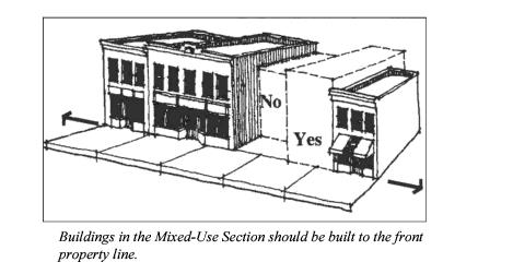
(Ord. No. 01-2021 § 1, 01/05/2021)
11-5-502 General Provisions.
(1) Uses in the Westfields Village Center are specified in the Table of Uses under the zoning classification of Village Center.
(2) The Westfields Village Center shall meet the requirements of the Commercial and Industrial Zones Site Development Standards for all nonresidential developments and vertical mixed-use developments (commercial on the first floor with residential or other uses above) and the requirements of the Residential Zones Site Development Standards for all solely residential uses unless specifically addressed within this Chapter.
(3) Site Plan and Design Review. All development within the Westfields Overlay Zone shall be subject to the Site Plan Review Chapter of the Zoning Ordinance, along with the design review criteria of this Chapter.
(4) Parking shall meet the requirements of off-street parking provisions found in Section 11-6-113 of the Zoning Code unless specifically addressed within this Chapter.
(5) Landscaping and fencing shall meet the requirements of the landscaping and fencing chapter of the Zoning Code.
(6) Within the Mixed-Use section, at least seventy-five percent (75%) of the block along the primary street shall include buildings located at the property line and within the Multi-Family section, at least seventy-five percent (75%) of the block along the primary street shall include building facade located no more than twenty feet (20') from the front property line.
(Ord. No. 07-2009, 04/07/2009; Ord. No. 01-2021 § 1, 01/05/2021)
11-5-503 Mix Standards.
The use mix for the net developable area (excluding rights-of-way) of land is as follows:
|
High Density Residential Area |
up to 60% |
|
Mixed-Use Area |
up to 30% |
|
Civic Use Area |
up to 10% |
In order to ensure construction of the Mixed-Use area in Village Center developments, no more than fifty percent (50%) of the multi-family residential area may be built in the development prior to beginning construction of the mixed-use portion of the Village Center. At the time fifty percent (50%) of mixed-use portion is under construction, submission may be made for the next twenty-five percent (25%) of multi-family development. At the time the remainder of the mixed-use portion is complete, the remaining twenty-five percent (25%) of multi-family residential development may be considered for approval.
(Ord. No. 07-2009, 04/07/2009; Ord. No. 01-2021 § 1, 01/05/2021)
11-5-504 Design Standards for Mixed-Use Sections of the Village Center.
(1) Architectural Character. Contemporary interpretation of traditional commercial buildings is encouraged. Design elements associated with traditional store facades, such as kickplates, large first-floor display windows, transoms, and cornice elements will be included.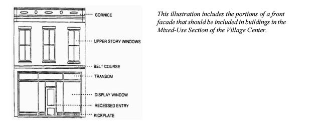
(2) Awnings shall be:
(a) Mounted to accentuate character-defining features of the facade.
(b) Semi-circular, odd shaped, bubble and bull-nose awnings are inappropriate.
(c) Back-lit awnings are not allowed.
(d) The angled plane of the awning shall appear larger than the vertical valance plane of the awning and the valance may not exceed fourteen inches (14").
(e) Awning signage shall meet the requirements of the Sign Code.
(f) Rigid-frame awnings may be used.
(3) Building Equipment.
(a) All building equipment and service areas, including roof and ground level HVAC and other equipment that is visible from a public street or way, shall be screened.
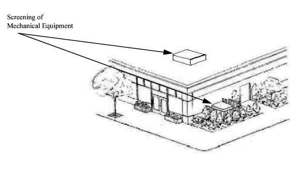
(b) Equipment placed on the roof should be set back at least fifteen feet (15') from any public street or way.
(4) Building Fenestration/Transparency.
(a) All first-floor facades facing a public street or way shall include clear windows in at least fifty percent (50%) of the primary street facade area. Glass in these areas may not be reflective, opaque or glass-block.
(b) The maximum length for any blank wall uninterrupted by windows, doors or architectural detailing at the first floor level shall be thirty feet (30').
(c) There shall be at least one (1) operable building entrance per elevation that faces a public street. Buildings on corner lots need only have one (1) operable building entrance, provided the facades of both streets meet the fifty percent (50%) window requirement.
(d) All second-floor facades facing a public street or way shall include clear windows in at least twenty-five percent (25%) of the facade area.
(e) Upper story windows shall have a vertical emphasis.
(f) Windows shall be set inside of the building face wall.
(5) Building Form.
(a) Arcades, colonnades and recessed entryways are encouraged.
(b) Rooftops should appear to be flat from public streets and ways. Parapets may be used to obscure pitched roofs.
(6) Building Mass and Scale.
(a) Large buildings should be divided into smaller modules or bays of twelve feet (12') to thirty feet (30') in width.
(b) Large projects that occupy over seventy-five feet (75') of frontage shall include varying building heights to provide variety to the streetscape.
(7) Building Materials.
(a) The primary building material for facades facing a public street or way shall be standard-sized brick, with carved, rusticated or dressed stone, cast concrete or stucco used as accent materials. First-floor storefronts may include wood or aluminum framing.
(b) Walls located between buildings, that will not be exposed, may be constructed of CMU (concrete masonry units).
(c) Rear facades adjacent alleyways or parking areas may include standard-sized brick, stone, cast concrete or stucco.
(8) Parking. Off-site parking shall be located behind the buildings, with access from side streets.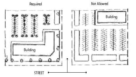
(9) Right-of-Way.
(a) Streets within the Mixed-Use section of the Village Center shall be designed as minor collectors to provide street side parking. Consideration may be given for angled parking in order to provide additional storefront parking.
(b) The streetscape plan for the Mixed-Use section shall meet the requirements of the Westfields right-of-way streetscape requirements, which shall include a minimum eight-foot (8') sidewalk. The parkstrip area will include eight-foot (8') by eight-foot (8') street tree planters spaced every forty feet (40') on center, separated by hard-surfaced brick pavers or similar treatment.
(c) The outdoor permanent sales or display of merchandise shall not encroach into areas of required sidewalk, landscaping or parking.
(d) At least five percent (5%) of the total floor area in the Mixed-Use section shall include a plaza or square with seating provided at a rate of one (1) sitting space per two hundred fifty (250) square feet, at least thirty inches (30'') wide and sixteen inches (16'') in height. Sitting spaces may include ledges or more formal benches. At least one (1) of the following elements shall be provided:
(i) One (1) tree per eight hundred (800) square feet of area;
(ii) Water features or public art; and/or
(iii) Outdoor eating areas or food vendors.
(10) Signage.
(a) Signage shall be in conformance with the Springville City Sign Ordinance.
(b) Permanent signage should not hide architectural features of the building or obscure windows.
(Ord. No. 07-2009, 04/07/2009; Ord. No. 01-2021 § 1, 01/05/2021)
11-5-506 Density Standards for the Mixed-Use Section of the Village Center.
Residential Density for the Mixed-Use Section of the Village Center shall allow for two (2) residential units for every one thousand (1,000) square feet of commercial space on the first floor. No residential unit may be less than six hundred (600) square feet and must be located above the first floor.
(Ord. No. 01-2021 § 1, 01/05/2021)
11-5-507 Density and Design Standards for Multi-Family Section of the Village Center.
The Multi-Family Section shall be subject to the same land use and development restrictions, standards and other requirements as the RMF-2 Zone and may receive a density bonus of up to one hundred twenty percent (120%) of the base density by meeting the requirements of the Westfields Density Bonus program.
(Amended by Ord. No. 27-05, 12/06/2005; Ord. No. 07-2009, 04/07/2009; Ord. No. 01-2021 § 1, 01/05/2021)
11-5-508 Design Standards for the Multi-Family Section of the Village Center.
(1) Lot area per dwelling in the Multi-Family Residential Section of the Village Center shall be one (1) dwelling unit per eight hundred (800) square feet of land area.
(2) The minimum parking requirement in the Multi-Family Residential Section of the Village Center shall be one and one-half (1-1/2) stalls per unit.
(3) No building or structure shall exceed a height of thirty-five feet (35'), exclusive of common underground parking areas which may not exceed ten feet (10') in additional height.
(Ord. No. 07-2009, 04/07/2009; Ord. No. 01-2021 § 1, 01/05/2021)
Article 6 – MIXED USE OVERLAY REGULATIONS
11-5-601 Purpose and Intent.
The purpose of the MU Mixed Use Overlay Zone is to provide opportunities for the development of a mix of commercial, office and residential uses at major intersections within Springville City. The intent of the zone is to:
(1) Help provide a full range of housing types within the City;
(2) Create housing near shopping and work opportunities to decrease vehicular trips and encourage pedestrian traffic;
(3) Provide a better balance between the amount of land used for residential and commercial uses;
(4) Meet the strategies of the Springville City General Plan to provide opportunities for mixed land uses and include higher density housing in connection with that mix.
(Ord. No. 04-2011, 03/15/2011)
11-5-602 General Requirements.
(1) The MU Mixed Use Overlay Zone shall be limited to parcels under single ownership located at the intersection of two (2) major streets. Major streets include arterial and major collectors as identified in the Springville General Plan.
(2) The area for such a development shall be at least twenty (20) acres and no greater than sixty (60) acres.
(3) The lot shall be zoned commercially and the commercial development shall be subject to the underlying zoning development requirements.
(4) Residential uses within the development shall be conditional and may be included horizontally or vertically in the overall mix of uses on the site.
(5) Any residential development in the overlay zone shall be multi-family dwellings and shall be located within one-quarter (1/4) mile of the commercial section of the project.
(6) Up to sixty percent (60%) of the land in the development may be used exclusively for residential development, inclusive of associated streets and open space.
(7) The RMF-1 Zone shall serve as the base density for those portions of the parcel used exclusively for multi-family residential uses.
(8) For vertical mixed use, which shall be residential located above a commercial main floor, density is limited by the ability to provide parking and building height maximums. Vertical mixed use will not be counted towards the sixty percent (60%) residential maximum.
(9) The portion of the parcel nearest the major intersection shall be the location of commercial uses, while other portions of the property may include commercial uses. Residential uses may be located above a main floor commercial space in a vertically mixed manner or may be located behind the commercial space or along major streets away from the primary intersection.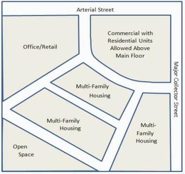
Fig. 1 The Mixed Use Overlay Zone must include Commercial at the intersection of either arterial or major collector streets
(10) Housing must either abut or be across the street from property zoned residentially (need to ensure minimum neighborhood population of three thousand five hundred (3,500) persons).
(Ord. No. 04-2011, 03/15/2011)
11-5-603 Development Standards.
The following minimum performance standards shall apply to all residential development in the MU Mixed Use Overlay Zone, including any vertical mixed use developed in connection with commercial properties. The base standards (which are the conditions for inclusion of housing in the project) shall meet the following requirements:
(1) Building Materials – At least fifty percent (50%) of the net facade areas of each elevation shall be in brick or stone with the remainder in stucco, wood or fiber cement siding. Other materials may be used as accent materials, but shall not consist of greater than five percent (5%) of any facade elevation. Brickwork must include one (1) element of coursing different from the major coursing on the building (i.e., the stretcher bond is the most typically used and a soldier, dogtooth or other coursing should be included as part of the overall brick application). This minimum standard may be used for a ten percent (10%) density bonus for those projects participating in the density bonus program;
(2) Window and door openings shall make up twenty percent (20%) of any front facade facing the street;
(3) Parking for all dwellings shall be located behind the principal building and may be accessed from a carriageway or driveway;
(4) Primary entries to buildings shall face a public street;
(5) At least fifty percent (50%) of the block length shall have building facades within thirty feet (30') of the front property line;
(6) The use of materials shall be consistent as to percentage or application of each facade on all sides of the building. This requirement shall not apply to materials used as accent materials not consisting of greater than five percent (5%);
(7) Building elevations facing a public street shall include projections, recesses, balconies, arcades and/or other distinctive features that provide relief to the facade at least every thirty (30) linear feet of frontage;
(8) Windows shall not be flush with exterior walls. All windows shall be recessed or treated with a trim. Such treatments shall be applied on all window edges and sides;
(9) Building shall include breaks in the roofline for buildings with pitched roofs, either through changes in building height or other methods;
(10) The minimum parking requirement for all residential areas of developments in the MU Mixed Use Overlay Zone shall be two (2) stalls per unit;
(11) No more than fifty percent (50%) of the exclusively horizontal multi-family residential area may be built in the development prior to beginning construction of the commercial or vertical mixed-use portion of the development in the MU Mixed Use Overlay Zone. At the time fifty percent (50%) of mixed-use portion is under construction, submission may be made for the next twenty-five percent (25%) of exclusively horizontal multi-family development. At the time all of the commercial or vertical mixed-use portion of the project is complete, the remaining twenty-five percent (25%) of multi-family residential development may be considered for approval.
(Ord. No. 04-2011, 03/15/2011; Ord. No. 09-2011 § 1, 06/07/2011; Ord. No. 06-2012, 07/17/2012; Ord. No. 01-2013, 01/15/2013)
11-5-604 Density Bonus.
(1) Densities in excess of the baseline density achievable under the RMF-1 zoning designation may be considered for developments choosing to participate in the density bonus program up to a maximum of seventy percent (70%).
(2) Participation in the density bonus program is contingent on meeting at least one (1) of the requirements from the Parks, Open Space and Other Public Lands category listed below. A density bonus of at least three percent (3%) must be achieved in this category. Springville reserves the right to accept or reject any areas proposed to meet this requirement. The applicant’s proposal for parks, trails, open space and other public land needs shall be reviewed in connection with areas proposed for such uses in the Springville General Plan. Upon transfer of the land with associated improvements, if applicable, the City shall be responsible for maintenance of the property, unless specified otherwise in a development agreement.
(a) Parks, Open Space and Other Public Lands.
|
Density Bonus Improvement |
Requirements and Bonus |
|---|---|
|
Linear open space and trails in connection with proposed waterways, hillside, or right-of-way corridors |
A seven-tenths percent (0.7%) density bonus for each one percent (1%) of land developed for a linear trail system at least twenty feet (20') wide within the development. The trail system shall become property of Springville City upon completion and acceptance by the City. Improvements shall include: grading improvements, ten-foot (10') wide hard-surfaced trail, benches every one-eighth (1/8) mile and landscaping, including at least three (3) trees per one hundred (100) linear feet. Other types of improvements may include trail heads. Parks shall include improvements totaling no less than the amount per acre established by resolution and approved by the City Council. |
|
Public property dedications |
A density bonus of one-half percent (0.5%) for each one percent (1%) of land identified by the City for a public purpose and deeded to the City. |
|
Fees in lieu |
A fee in lieu of physical improvements may be paid to the City at the rate of the value of the land per acre plus improvements totaling no less than the amount per acre established by resolution and approved by the City Council and be prorated at one and two-tenths percent (1.2%) density bonus for the equivalent value of one percent (1%) land and development costs. This fee is to be used for open space land acquisition or linear park trails. |
(b) Building Materials.
|
Density Bonus Improvement |
Requirements and Bonus |
|---|---|
|
Exterior Building Materials * The net facade applies to all sides of the building. |
A density bonus of ten percent (10%) will be granted for those projects meeting the minimal building materials requirement who chose to participate in the density bonus program. An additional ten percent (10%) density bonus will be granted for an additional twenty-five percent (25%) of the net facade area* being covered with brick or stone and meeting the other minimal building materials requirements. An additional ten percent (10%) density bonus will be granted for those portions of the facade area not required to be covered in brick or stone, along with any gable areas, being covered with at least two (2) patterns of concrete or wood fiber board. |
(c) Design Features – Specific building features help to provide interest and variety to the whole array of residential facades. It is important that these design elements are appropriate to the architecture of the building and appropriately located in that architecture. These will be considerations in awarding density bonuses for this category.
|
Density Bonus Improvement |
Requirements and Bonus |
|---|---|
|
Projecting bays |
A density bonus of up to four percent (4%) may be given for projecting bays at least two feet (2') deep covering at least fifteen percent (15%) of the front facade, based on materials and appropriateness of location. |
|
Balconies/Decks |
A density bonus of up to two percent (2%) to seven percent (7%) may be given for balconies covering at least fifteen percent (15%) of a facade facing a street and which extend at least one foot (1') on each side beyond the width of the doorway. (i) A density bonus of up to two percent (2%) may be given for a basic projecting, unenclosed balcony of at least three feet (3') in depth and twenty (20) square feet of area. (ii) A density bonus of up to four percent (4%) may be given for a balcony/deck covered with a nonintegral roof and five feet (5') in depth. (iii) A density bonus of up to five percent (5%) may be given for a balcony/deck at least five feet (5') in depth with an integral roof integrated that reflects or complements the roof type (e.g., hipped, gabled). (iv) A density bonus of up to seven percent (7%) may be given for a balcony/deck at least five feet (5') in depth with an integral roof that reflects or complements the roof type (e.g., hipped, gabled or clipped gable) and enclosed sidewalls. |
|
Dormer windows |
A density bonus of up to two percent (2%) may be given for dormer windows based on materials and appropriateness of location. |
|
Window types and treatment |
A density bonus of up to two percent (2%) may be given for window opening accents on all front facade windows, such as a window head (e.g., pediment or hooded) and a projecting sill (e.g., precast or brick) along with keystones, brick soldier coursing above the window, etc. |
|
Landmark feature |
A bonus density of up to five percent (5%) shall be given for a unique entryway, architectural or landscape architectural feature that provides unique identification for the development. |
(d) Garages or Underground Parking.
|
Density Bonus Improvement |
Requirements and Bonus |
|---|---|
|
Enclosed garage |
A forty percent (40%) bonus density will be given for providing two (2) side-by-side parking spaces per unit in an enclosed garage. Garages shall meet the requirements of parking stalls in terms of location and access. This bonus may be applied to only a portion of the units in a development and the bonus density will be prorated (e.g., twenty-five percent (25%) of the units including two (2) car garages would result in a ten percent (10%) density bonus). |
|
Underground parking |
A prorated density bonus of up to seventy-five percent (75%) may be given for common underground parking garages in multiple-family dwelling structures which include internal circulation. |
(e) Participation in the National Association of Home Builder’s Green National Standards Program will provide a density bonus, based on the rating achieved. This program has been developed to help conserve energy, water and other resources, along with utilizing sustainable or recycled materials in construction of homes. A verification of certification must be provided by the developer to receive the density bonus.
|
Density Bonus Improvement |
Requirements and Bonus |
|---|---|
|
Bronze rating |
Density bonus of 5% |
|
Silver rating |
Density bonus of 10% |
|
Gold rating |
Density bonus of 15% |
(Ord. No. 04-2011, 03/15/2011; Ord. No. 06-2012, 07/17/2012)
11-5-605 Submission and Approval Process.
(1) The submittal and processing requirements found in the Springville City Code Westfields Overlay Regulations, Sections 11-5-408 through 11-5-415, shall be followed for all developments within the MU Mixed Use Overlay Zone. The concept plan shall also show the general location of all nonresidential buildings and structures.
(2) Any development in the MU Mixed Use Overlay Zone shall be processed as a subdivision, as described in Title 14, if new lots or streets are being created. Any development not meeting the criteria for subdivision shall be subject to site plan review pursuant to Title 11, Chapter 7, Article 4. Development approvals of the concept plan, preliminary plan and final plats shall be effective as described in Title 14. Participants in the density bonus program may not submit the concept and preliminary plans simultaneously. Density bonus program developments will be subject to one (1) additional step in the subdivision review process, which shall be a review and approval of the preliminary plan by the City Council.
(Ord. No. 04-2011, 03/15/2011)
Article 7 – MATERIALS PROCESSING AND STORAGE OVERLAY REGULATIONS
11-5-701 Purpose and Intent.
The purpose of the Materials Processing and Storage (MPS) Overlay Zone is to accommodate the processing and storage of bulk materials in the underlying Light Industrial Manufacturing (LIM) Zone while minimizing potential adverse effects of the outside use to adjacent property owners and the surrounding community and paying special attention to the visual aesthetics associated with the use.
(Ord. 26-2019 § 1, 12/10/2019)
11-5-702 Effect of Overlay.
(1) The uses permitted and regulations established by the Materials Processing and Storage Overlay shall be in addition to those uses permitted and regulations established in the underlying LIM Zone.
(2) Where conflicts exist between the provisions of the Materials Processing and Storage Overlay and the underlying Light Industrial Manufacturing Zone, the regulations of the Materials Processing and Storage Overlay shall supersede the requirements of the underlying LIM Zone.
(Ord. 26-2019 § 1, 12/10/2019)
11-5-703 Permitted Uses.
(1) Storage of sand, gravel, earth or stone.
(2) Recycling of concrete, wood and paving materials.
(Ord. 26-2019 § 1, 12/10/2019)
11-5-704 Location Requirements.
(1) The MPS Overlay Zone may only be applied to the LIM Zone located east of 950 West, South of 1600 South, and West of SR 51.
(2) The procedure for applying the MPS Overlay Zone to a property shall be the same procedure for amending the zoning map as set forth in Section 11-7-102.
(3) Each parcel within the MPS Overlay Zone shall have frontage on and direct access to a major arterial road.
(Ord. 26-2019 § 1, 12/10/2019)
11-5-705 Screening.
(1) Each property to which this overlay is applied shall install and maintain a minimum street frontage landscape border width of twenty feet (20').
(2) One (1) large evergreen tree (or deciduous, dense-canopied tree with the approval of the Director of Buildings and Grounds), every twenty linear feet (20') with a minimum mature height of thirty feet (30'). Other shrubbery and plantings shall also be included in the buffer area with a minimum of five (5) shrubs per twenty linear feet (20').
(3) Six-foot-tall (6') solid fencing shall be installed to the rear of the street frontage landscape border.
(Ord. 26-2019 § 1, 12/10/2019)
11-5-706 Business License Regulations.
Each materials processing and storage operation shall obtain a business license and operate in compliance with any current and future business license regulations applicable to materials processing and storage businesses. Where conflicts exist between the provisions of any materials processing and storage overlay regulations in this Chapter and any current or future business license regulations applicable to materials processing and storage business activities, the business license regulations shall supersede the provisions of the materials processing and storage overlay regulations. The City reserves its right to regulate material processing and storage overlay business operations in the future, which includes changing operational regulations as part of the business licensing process. Nothing in this Article shall vest an applicant in operational regulations, including, but not limited to, height and volume of storage material, recycling locations, hours of operation, and roadway operations.
(Ord. 26-2019 § 1, 12/10/2019)
11-5-707 Operational Regulations.
(1) Material Storage Requirements. Materials processing and storage in the Overlay Zone shall operate as follows:
(a) Storage or stockpiles of materials shall not exceed twenty feet (20') in height.
(b) Volume of materials on any lot or parcel shall not exceed two thousand five hundred (2,500) cubic yards multiplied by the number of acres in the lot or parcel.
(c) Stored material shall not emit any dust, particles, fumes, dirt, vapors or odors beyond the business’s property boundaries.
(2) Material Recycling Requirements.
(a) When processing and recycling material, including, but not limited to, concrete, wood, asphalt and other paving materials, a licensee shall not emit any dust, fumes, dirt, particles, vapors, odors, waste, or noise above sixty (60) decibels beyond the business’s property boundaries.
(b) No material recycling activities shall take place within one thousand (1,000) feet of a residence.
(c) As part of the site plan approval, an applicant shall provide an operational plan for how the applicant is going to ensure the applicant’s recycling operations will comply with the requirements in subsection (1) of this Section and this subsection. Applicant shall follow the operation plan approved as part of the site plan approval process, unless the operational plan conflicts with a future business license regulation.
(d) All State, Federal and local laws and regulations for recycling materials shall be followed.
(3) Hours of Operation. Materials processing and storage businesses within the Overlay Zone shall only operate within the hours of 7:00 a.m. to 7:00 p.m.
(4) Roadways.
(a) Materials processing and storage businesses within the Overlay Zone shall only use major arterial roadways as haulage routes within the limits of the City.
(b) Trucks shall not disturb the operation of roadways while entering or exiting the site. As part of site plan approval, an applicant shall provide a written operational plan showing how an applicant’s trucks and other vehicles will not disrupt or disturb in any way the operation of roadways. The submitted roadway operational plan must be based on a traffic engineering study approved by the City Engineer before the applicant receives final site plan approval. The City Engineer will rely on traffic engineering standards in determining whether the roadway operational plan should be approved.
(Ord. 26-2019 § 1, 12/10/2019)
Article 8 – TRADITIONAL NEIGHBORHOOD DEVELOPMENT (TND) OVERLAY ZONE
11-5-801 Purpose and Intent.
The purpose of this zone is to accommodate the development of traditional neighborhoods through the adoption of form-based code regulating plans, lot types and other associated regulations.
(Ord. 16-2021 § 1, 09/07/2021)
11-5-802 Definitions.
In addition to those definitions found in Section 11-3-402, the following words shall have the definitions in this Article:
“Active Transportation Plan” means the current Springville Active Transportation Plan as adopted and amended by the City Council from time to time.
“Civic building zone” means a site dedicated for buildings generally operated by government entities or not-for-profit organizations with a dedicated use for culture, education, religion, government, transit and municipal parking, or for a use approved by the City Council.
“Civic space” or “civic zone” means either a civic building zone or a civic space zone.
“Civic space zone” means a public site permanently dedicated to open space for use by the general public.
“Development area” means the total area of each traditional neighborhood development overlay zone.
“Lot type” means a specific set of requirements establishing the parameters of development for each lot.
“Neighborhood unit” means a regulatory category defining the physical form, density, and extent of a settlement.
“Net site area” means cumulative of all areas of the new neighborhood plan that are not part of the T1 and T2 zones and exclusive of thoroughfares and land assigned to civic zones.
“New neighborhood plan” means the sum of regulations adopted to implement each traditional neighborhood zone area.
“Public frontage” means that space along a thoroughfare or civic space that includes sidewalks, curbs, planters, bicycle facilities and street trees. The public frontage contributes to the character of the transect zone.
“Special planning area” means an area of land to which the TND zone has been applied and for which a new neighborhood plan has been adopted.
“Thoroughfare” means a way for use by vehicular and pedestrian traffic and to provide access to lots and open spaces, consisting of vehicular lanes and the public frontage.
“Transect zone” or “T-zone” means one (1) of several sub-zones within an area regulated by the traditional neighborhood development. Transect zones are administratively similar to the land use zones in conventional codes, except that in addition to the usual building use, density, height, and setback requirements, other elements of the intended habitat are integrated, including those of the private lot and building and public frontage.
“Vehicle lane dimensions” means. the standards for vehicular lane width as shown in vehicular lane dimensions in each thoroughfare standard.
(Ord. 16-2021 § 1, 09/07/2021)
11-5-803 TND Overlay Zone Application.
(1) Development Agreement. When a property is zoned with the TND Overlay Zone, the TND Overlay Zone shall not change the underlying zone and become effective until the property owner and City have entered into a development agreement that outlines how the requirements of the TND Overlay Zone apply within the special planning area. The development agreement must include, without limitation, the following:
(a) An adopted new neighborhood plan;
(b) A term that does not exceed five (5) years or the minimum number of years allowed by the Utah Municipal Land Use, Development and Management Act, whichever number is lower;
(c) A provision that allows both parties to choose in writing whether to continue the initial term of the agreement and allow the new neighborhood plan to continue;
(d) A statement that the developer is not vested in the neighborhood plan and the City Council may change the neighborhood plan at any time after its adoption in order to make appropriate changes to meet the interests of the City as development happens;
(e) A statement that all Springville City land use regulations apply to the special planning area that are not revised by the new neighborhood plan; and
(f) An agreement by the developer to abide by all design standards, as required by Section 10-9a-534, Utah Code Annotated 1953, and any other Utah Code sections; and
(g) A timeline for when the developer shall construct and install the civic space, along with penalties for not installing the civic space in accordance with the timeline.
(2) Minimum Area of Zone. The TND Overlay Zone may be applied to any size of development areas.
(3) New Neighborhood Plan.
(a) No development entitlement exists under the TND Overlay Zone until the adoption of a new neighborhood plan that meets the requirements of this Article.
(b) The new neighborhood plan shall include those regulations for the development that supplement Springville City’s land use regulations for the special planning area.
(c) All of Springville City’s land use regulations that are not revised by the new neighborhood plan shall remain in effect for the special planning area.
(d) A developer is not vested indefinitely in the new neighborhood plan once it is adopted. The City Council may still revise the new neighborhood plan to meet the interests of the City, and the developer shall be required to follow any revisions of the new neighborhood plan.
(Ord. 16-2021 § 1, 09/07/2021)
11-5-804 New Neighborhood Plans.
(1) Preparation and Adoption of New Neighborhood Plans.
(a) A new neighborhood plan may be prepared by the Planning Department, property owner, and/or consultant. New neighborhood plans may contain more than one (1) T-zone and/or shall contain more than one (1) lot type.
(b) A new neighborhood plan must be adopted through legislative action of the City Council upon recommendation from the Planning Commission. The City Council maintains all of its legislative rights and authorities in considering a new neighborhood plan and is not required to adopt a new neighborhood plan.
(c) Upon adoption of a new neighborhood plan by the City Council, the parcel subject to the new neighborhood plan shall become a special planning area and shall be marked as such on the zoning map. Within the special planning area, this Code shall govern all development and shall supersede any other conflicting provisions of the Springville Municipal Code.
(2) New neighborhood plans shall include the following:
(a) Transect zone descriptions;
(b) A regulating plan consisting of one (1) or more maps showing and regulating at least the following, in compliance with the standards described in this Article:
(i) Transect zones,
(ii) Civic zones,
(iii) Thoroughfare network,
(iv) Special requirements, if any, and
(v) Calculation of permitted density;
(c) Standards for each lot type, including at least:
(i) Type description,
(ii) Lot dimension,
(iii) Dimensional standards keyed to graphic diagram,
(iv) Height, and
(v) Form-based graphic diagram;
(d) A table of permitted lot types within each transect zone;
(e) One (1) set of preliminary site plans for each transect zone.
(3) New neighborhood plans may include the following:
(a) Thoroughfare standards;
(b) Civic space standards;
(c) Storm water management standards;
(d) Architectural standards; or
(e) Landscape standards.
(Ord. 16-2021 § 1, 09/07/2021)
11-5-805 Requirements for New Neighborhood Plan Elements.
(1) Transect Zones.
(a) Transect zones shall be assigned and mapped on each new neighborhood plan.
(b) A transect zone may include any of the elements indicated for its T-zone number throughout this Code, in accordance with the transect zone descriptions.
(2) Civic Space.
(a) Civic space dedicated for public use shall be required for each neighborhood unit and designated on the new neighborhood plan as a civic space zone and/or civic building zone.
(b) The City has to approve all civic space as part of the neighborhood plan.
(c) The developer shall be required to install and receive approvals from the City for the civic space associated with or located within each development phase, or provide an adequate improvement completion assurance for the civic space, before any certificates of occupancy will be given for that phase.
(3) Thoroughfare Standards.
(a) If no specific thoroughfare standards are adopted with the new neighborhood plan, the existing City land use regulations for thoroughfare standards shall apply.
(b) If specific thoroughfare standards are adopted, they shall adhere to the following standards and shall supersede the otherwise adopted City standards:
(i) General.
(A) Thoroughfares are intended for use by vehicular and pedestrian traffic and to provide access to lots and open spaces.
(B) Thoroughfares shall generally consist of vehicular lanes and public frontages.
(C) Thoroughfares shall be designed in context with the urban form and desired design speed of the transect zones through which they pass.
(D) Frontages of thoroughfares that pass from one (1) transect zone to another shall be adjusted accordingly or, alternatively, the transect zone may follow the alignment of the thoroughfare to the depth of one (1) lot, retaining a single public frontage throughout its trajectory.
(E) Within the most rural zones (typically named the T1 and T2 zones within a neighborhood development plan) pedestrian comfort shall be a secondary consideration of the thoroughfare. Design conflict between vehicular and pedestrian generally shall be decided in favor of the vehicle.
(F) Within the more urban transect zones (typically named T3 through T6 zones) pedestrian comfort shall be a primary consideration of the thoroughfare. Design conflict between vehicular and pedestrian movement generally shall be decided in favor of the pedestrian.
(G) The thoroughfare network shall be designed to define blocks. A block shall not exceed three hundred feet (300') by six hundred feet (600'). The perimeter shall be measured as the length of the right-of-way line at the perimeter of the block.
(H) All thoroughfares shall terminate at other thoroughfares, forming a network. Internal thoroughfares shall connect wherever possible to those on adjacent sites.
(I) Each lot shall front on a vehicular thoroughfare or a path or trail in a civic space zone. In the event that a lot fronts on a path or trail, the new neighborhood plan must demonstrate how the lots will be easily accessed by both lot owners and people visiting the lot. Front doors of homes need to have available public parking within one hundred fifty feet (150') of the door, and lots need to be easily accessed by owners by either a public street or private alley.
(J) Standards for paths and bicycle trails shall conform to the Active Transportation Plan.
(ii) Vehicular Lanes.
(A) Thoroughfares may include vehicular lanes in a variety of widths for parked and for moving vehicles, including bicycles. The standards for vehicular lanes shall be as shown in vehicular lane dimensions.
(B) A bicycle network consisting of bicycle trails, bicycle routes and bicycle lanes should be provided throughout the special planning area as defined in the Active Transportation Plan. The community bicycle network shall be connected to existing or proposed regional networks as defined in the Active Transportation Plan.
(iii) Public Frontages.
(A) The introduced landscape shall consist primarily of native species requiring minimal irrigation, fertilization and maintenance and tolerant of soil compaction.
(B) The public frontage shall include trees planted in a regularly spaced allée pattern of single or alternated species with shade canopies of a height that, at maturity, clears at least ten feet (10').
(C) At retail public frontages, the spacing of the trees may be irregular, to avoid visually obscuring the shopfronts.
(4) Density Calculations.
(a) The net site area shall be allocated to the various transect zones as defined by the new neighborhood plan.
(b) Density shall be expressed in terms of housing units per acre as specified for the area of each transect zone. For purposes of density calculation, the transect zones do not include the thoroughfares or land assigned to civic zones.
(c) The City is not required to approve and adopt a new neighborhood plan that allows for higher densities than the underlying zone within the TND Overlay Zone.
(5) Special Requirements. A new neighborhood plan may designate any of the following special requirements:
(a) Designations for mandatory and/or recommended retail frontage requiring or advising that a building provide a shopfront at sidewalk level along the entire length of its private frontage. The shopfront shall be no less than seventy percent (70%) glazed in clear glass and shaded by an awning overlapping the sidewalk. The first floor shall be confined to retail use for the first forty feet (40').
(b) Designations for mandatory and/or recommended gallery frontage, requiring or advising that a building provide a permanent cover over the sidewalk, either cantilevered or supported by columns. The gallery frontage designation may be combined with a retail frontage designation.
(c) Designations for mandatory and/or recommended arcade frontage, requiring or advising that a building overlap the sidewalk such that the first-floor facade is a colonnade. The arcade frontage designation may be combined with a retail frontage designation.
(d) A designation for coordinated frontage, requiring that the public frontage and private frontage be coordinated as a single, coherent landscape and paving design.
(e) Designations for mandatory and/or recommended terminated vista locations, requiring or advising that the building be provided with architectural articulation of a type and character that responds visually to the location.
(f) A designation for cross block passages, requiring that a minimum eight foot (8') wide pedestrian access be reserved between buildings.
(Ord. 16-2021 § 1, 09/07/2021)