


Chapter 18.07
SHORELINES ENVIRONMENT DESIGNATIONS
Sections:
18.07.040 Shorelines area designations.
18.07.010 General.
A. Shoreline Environment – Applicability.
1. Burlington’s shorelines under the shoreline master program are limited to those portions of the Skagit River, corresponding shorelands and the Gages Slough wetlands that occur within the city’s corporate limits, as detailed in BMC 18.09.060. For the purpose of this SMP the floodway is at the waterward top of the levee as depicted in Figure 1.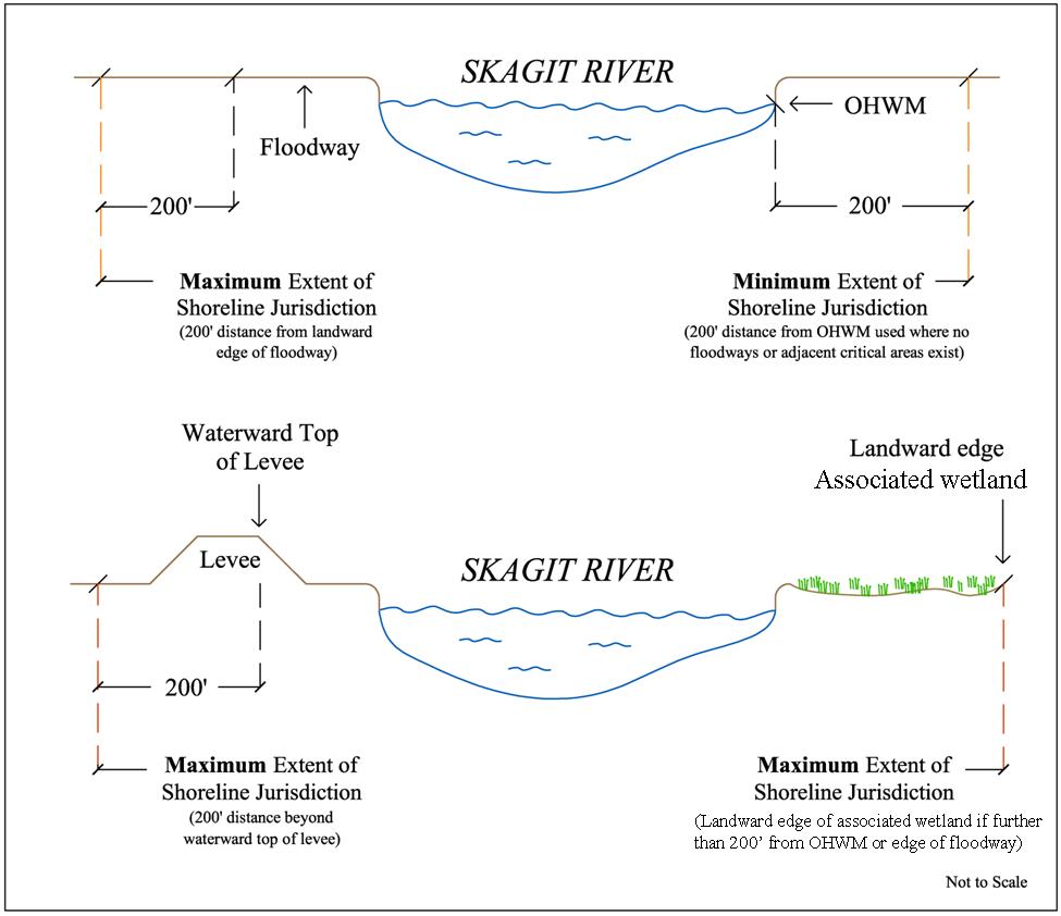
Figure 1. Shoreline Management Zone
(Note: This is a conceptual diagram only, and not a specific description of particular river locations. True floodway and jurisdictional extent will be determined at the time of permitting.)
B. Environmental Designations.
1. The Shoreline Management Act requires that each identified shoreline environment be given a designation, based on its physical condition and development pattern. The environmental designations provide a framework for implementing shoreline policies and regulations specific to each shoreline environment.
2. The Burlington shoreline master program has environmental designations based on the following:
a. Ecosystem characteristics and environmental functions;
b. Restoration potential;
c. Existing uses;
d. Development and redevelopment potential; and
e. Public and private plans.
3. Shorelines not found to be mapped or designated, such as through an annexation, will be assigned an urban conservancy environmental designation until such time that the SMP is updated to include analysis and appropriate designation of those shorelines.
C. Mapping.
1. An up-to-date and accurate map of the shoreline area, delineating the environmental designations, is maintained at the planning and community development department.
2. A list of shoreline properties, identified by Skagit County tax assessor parcel number, with their environmental designations, is maintained at the planning and community development department.
3. In the event of a mapping error, the designation criteria in conjunction with specific locational descriptions contained in this section shall prevail. The environmental designation boundaries, physical features, explicit criteria, or “common” boundary descriptions that define and distinguish the environments are included in BMC 18.07.040. (Ord. 1786 § 1, 2013).
18.07.040 Shorelines area designations.
A. Urban Conservancy Environment.
1. Purpose. The purpose of the urban conservancy environment is to protect and restore ecological functions of open space, floodplain, and other sensitive lands where they exist in developed shoreline settings, while allowing for compatible uses and public access.
2. Designation Criteria. The urban conservancy environmental designation has been assigned to the shorelines that meet the following criteria:
a. Existing open space within the floodplain including riverfront levees;
b. Existing and/or restored shoreline habitat including wetland sites;
c. Potential for ecological restoration;
d. Existing or potential for water-related recreation and public access.
3. Location of Environment.
a. Skagit River shoreline management zone upland from ordinary high water.
b. Gages Slough delineated wetland corridor extending from the east city limits to, and including, the Goldenrod Bridge corridor west of Interstate 5.
4. Management Guidelines.
a. Uses that preserve the natural character of the area or promote preservation of open space, floodplain, or sensitive lands either directly or over the long term should be the primary allowed uses.
b. Public utilities, including the city of Burlington wastewater treatment plant, are allowed in the urban conservancy environmental designation.
c. Where levees are located within the urban conservancy environmental designation, additional new flood risk reduction measures may be constructed.
d. New residential, commercial, or industrial uses should not be allowed in the urban conservancy environmental designation.
e. Public access and public recreation objectives should be implemented whenever feasible and where significant ecological impacts can be mitigated.
f. During development and redevelopment, all reasonable efforts should be taken to restore ecological functions.
B. Natural Environment.
1. Purpose. The purpose of the natural environment is to protect those shoreline areas that either currently provide intact ecological functions or represent opportunities where these functions can be largely restored.
2. Designation Criteria. The natural environment has been assigned to those shoreline areas that meet the following criteria:
a. The shoreline is relatively undeveloped with structures and roads;
b. The shoreline has not historically been in recreation or urban uses; and
c. There is existing or the potential for restoration of ecological functions and connectivity to the adjacent floodplain and associated wetlands.
3. Location of Environment. The natural environment applies to the following location: Gages Slough wetland area west of Goldenrod Bridge corridor, extending to the city limits.
4. Management Guidelines.
a. Residential, commercial, industrial, and active recreation (sport fields) uses should not be allowed.
b. Passive recreation uses such as trails and viewpoints and low-intensity water dependent recreational access may be allowed where feasible and ecological impacts can be mitigated.
c. Scientific, historical, cultural, educational, and research uses may be allowed; provided, that no significant ecological impact on the area would result.
d. Additional wetland areas may be reclassified to natural as restoration projects are implemented, monitored and maintained.
C. Aquatic Environment.
1. Purpose. The purpose of the aquatic environment is to protect, restore, and manage the unique characteristics and resources of the area waterward of the ordinary high water mark (OHWM) in the Skagit River corridor.
2. Designation Criteria. The aquatic environment designation has been assigned to shoreline areas waterward of the OHWM.
3. Location of Environment. In Burlington, the aquatic environment is applicable only to the main stem of the Skagit River waterward of the OHWM. The city limit line is the midpoint of the river, and the shoreline management zone extends to that line.
4. Management Guidelines.
a. New over-water structures should be prohibited except for water-dependent uses, recreation, public access, critical infrastructure or ecological restoration.
b. The size of new over-water structures should be limited to the minimum necessary to support the structure’s intended use.
c. Provisions for the aquatic environment should be directed towards maintaining and restoring habitat for priority aquatic species.
d. Uses that cause significant ecological impacts to Skagit River habitats should be discouraged.
e. Shoreline uses and development should be designed and managed to prevent degradation of water quality and alteration of existing hydrographic conditions.
f. All developments and activities using navigable waters or their beds should be located and designed to minimize interference with surface navigation, to minimize adverse visual impacts, encourage multiple uses and to allow for the safe, unobstructed passage of fish whose life cycles are dependent on such migration. (Ord. 1786 § 1, 2013).