


Chapter 11.76
PLANNED UNIT DEVELOPMENT OVERLAY DISTRICT (PDD)
Sections:
11.76.030 Demonstrating public benefit.
11.76.040 Planned unit development superimposed—Effect.
11.76.050 Complete application.
11.76.060 Application procedure.
11.76.080 General requirements.
11.76.090 Development standards.
11.76.130 Subdivision requirements.
11.76.010 Intent.
The intent of this chapter is to provide a means of allowing development to occur that is not limited to the strict application of the Chelan County zoning resolution. The careful use of discretion by the hearing examiner to approve, deny or modify the proposal submitted by the developer may be required to achieve the purposes of this chapter and to carry out the objectives and intent of the comprehensive plan.
More specifically, it is the intent of this chapter to:
(1) Allow some flexibility in design and development that will result in a more desirable and efficient use of land by reviewing developments on a project level rather than on a building-by-building or lot-by-lot basis typical of the rest of the zoning resolution.
(2) Permit some flexibility of design, placement of improvements, use of open spaces, pedestrian and vehicular circulation, parking areas and other design elements to better utilize unique site characteristics.
(3) Produce an integrated and balanced development of mutually supportive uses that might otherwise be inharmonious.
(4) Provide a guide for the development community and county representatives who review and approve developments to ensure the standards and purposes of this chapter are met.
(5) Provide a variety of environments for living, and/or working, and/or recreational activities for the interest of the general public. (Res. 2006-44 (part), 4/4/06: Res. 2000-129 (part), 10/17/00).
11.76.020 Applicability.
(1) This chapter is applicable in all zoning districts in the unincorporated portions of Chelan County. The procedural provisions for the unincorporated urban growth area boundaries for the cities of Leavenworth, Cashmere, Wenatchee, Entiat, Manson and Chelan shall follow this chapter’s process. The provisions of this chapter can be utilized for any residential, commercial and/or industrial project. The planned unit development (PUD) district provides an alternative form of development through flexibility and creativity in site layout and design. Therefore this chapter is applicable only to design and site layout. The density and primary use limitations of the underlying district still apply. Planned unit densities may be allocated across adjoining lots and the various zoning districts when allowed within the district. The placement of allocated residential/commercial units derived from the planned unit subdivision process may be located within the best development sites of combined properties.
(2) This chapter is not intended to abrogate any performance or use restrictions or conditions set forth in the underlying zone for uses listed as permitted, accessory, conditional or administrative uses as set forth in this title. (Res. 2006-44 (part), 4/4/06: Res. 2000-129 (part), 10/17/00).
11.76.030 Demonstrating public benefit.
Any applicant for a planned unit development will have the burden of demonstrating that their proposal will achieve a public benefit as a result of any deviation from underlying zoning regulations through the creation of open space or public facilities, conservation, superior project design and/or function, needed private facilities or otherwise, and clearly implements the goals and policies of the comprehensive plan. (Res. 2006-44 (part), 4/4/06: Res. 2000-129 (part), 10/17/00).
11.76.040 Planned unit development superimposed—Effect.
The result of the use of this process is to superimpose each approved planned unit development on the underlying use zone regulations as an exception to such regulations to the extent that such approved planned unit development shall modify and supersede the regulations of the underlying zone. (Res. 2006-44 (part), 4/4/06: Res. 2000-129 (part), 10/17/00).
11.76.050 Complete application.
A complete application for a planned development shall consist of all the information required by Section 11.76.060, all documentation required by Title 13 of the Chelan County Code (SEPA), any analysis and mitigation plans required by Chapters 11.78, 11.80 and 11.86 of this title, the requirements of Title 14 and the prescribed application fees. (Res. 2006-44 (part), 4/4/06: Res. 2000-129 (part), 10/17/00).
11.76.060 Application procedure.
(1) The owner of any property in Chelan County or his/her authorized agent may initiate planned development projects. All property owners in the proposed planned development district may initiate joint applications involving multiple ownerships. Such applications shall be made in accordance with the provisions of Section 14.06.010 of Title 14, Development Permit Procedures and Administration, of the Chelan County Code, as amended; on forms provided by the Chelan County department of building, fire safety and planning together with the established filing fee. The applicant(s) for a PUD shall file a preliminary plan with the department of building, fire safety and planning, a planned unit development application, required SEPA documents per Chapter 197-11 WAC, and a plan for the area within the boundary of the project which shall be drawn to a scale of at least one hundred feet to one inch, showing at least, but not limited to, the following features:
(A) The proposed uses and their locations;
(B) The boundaries of the site;
(C) The names and dimensions of all streets touching the site of the proposed development and all proposed public dedications;
(D) The location and access points for all on-site parking facilities;
(E) The location of all major features such as railroads, drainage canals, shorelines and areas of a critical nature (including designated frequently flooded areas, geologically hazardous areas, aquifer recharge areas, fish and wildlife habitat conservation areas, and wetlands);
(F) Proposed distribution of structures showing generalized building footprints, exterior design and/or elevation views;
(G) Other written or graphic information necessary for review in the evaluation of the proposal;
(H) Proposed locations and dimensions of all common open space;
(I) If the development is proposed to occur in phases, a graphic breakdown of each phase as it relates to the whole development and its general timetable for completion;
(J) Topographic contours at intervals appropriate to project.
In addition to the above requirements, the applicant(s) shall supply a written statement for the development setting forth detailed information concerning the following subjects as they may be involved in the development, including, but not limited to:
(K) Proposed ownership method for all common areas (refer to Section 11.76.090(8)(A);
(L) Proposed operation and maintenance of the development and landscaping including provisions to assure permanence and maintenance of common open spaces and landscaping;
(M) Proposed homeowners’ association and/or protective covenants.
(2) Preliminary Plan. The hearing examiner shall review the preliminary plan at a duly publicized public hearing. The hearing examiner shall determine that the preliminary plan complies with the development policies of the comprehensive plan, and the provisions of this chapter. Such preliminary approval or subsequent revision shall be binding as to the general intent and apportionment of land and building, stipulated use, and circulation patterns and shall not be construed to render inflexible the final design of the project. The hearing examiner may attach any reasonable conditions to its preliminary approval to mitigate adverse impacts on the project’s neighbors, the neighborhood, or the county as a whole that might result from this development as originally proposed.
(3) Final Plan. Following hearing examiner approval of the preliminary development plans at a closed record hearing, the developer may submit final plans incorporating any changes required in the preliminary approval. In addition to the required elements of the preliminary plan set forth above, the final plan shall contain the following:
(A) Circulation plan, including road plans and profiles, surfacing improvements and nonvehicular facilities (pedestrian and bicycle paths);
(B) Landscape plan, including existing vegetation and features to be preserved, open space, and perimeter landscaping including provisions for permanent irrigation of landscaped areas;
(C) Topographic contours at five-foot intervals;
(D) Stormwater drainage plan;
(E) Locations and provisions for fire protection facilities;
(F) Provisions for domestic water, sewage and solid waste disposal;
(G) Location, dimensions and design of all off-street parking facilities showing points of ingress and egress from the site.
(4) Preliminary and Final Plans Combined. The foregoing procedure shall not preclude the developer, at his option, from obtaining final disposition of both preliminary and final development plans at one public hearing. The developer must request this combined consideration at the time of initial application and supply all the information required by subsections (1) and (2) of this section. (Res. 2006-44 (part), 4/4/06: Res. 2000-129 (part), 10/17/00).
11.76.070 Permitted uses.
Primary uses permitted within the planned unit development overlay district (PUD) are limited to those that are allowed as permitted, administrative or conditional uses in the zone in which the development is located. Accessory uses that are commonly associated with permitted, administrative and conditional uses are allowed as well as other ancillary uses that directly benefit and support the primary uses within the development. Within multiple zone districts with conflicting interest/uses the administrator shall review and resolve any questions involving the proper interpretation of application of the provisions of this title/ section that may be requested by any property owner, tenant, government officer, department or other person affected, and shall be required and be filed consistent with the provisions of Section 11.02.060. (Res. 2006-44 (part), 4/4/06: Res. 2000-129 (part), 10/17/00).
11.76.080 General requirements.
(1) Time Limitation. Within five years from the date of approval of a preliminary development plan by the hearing examiner (seven years for any PUD approved between December 2007 and December 2014), unless phased approval provides otherwise and is not in conflict with Chapter 58.17 RCW or Title 12 of the Chelan County Code, the applicant shall submit a final development plan for the PUD or a stage thereof for approval. If, at the date of expiration of the five-year time period, a final development plan has not been filed for approval with the hearing examiner, or at any time after a final plan has been approved it appears that the project is not progressing in a reasonable and consistent manner or the project has been abandoned, the project will be considered abandoned and the permit for the PUD will be revoked by the hearing examiner. When revocation has been enacted upon a PUD, the zoning designation shall revert to the land use designation for that location in the Chelan County comprehensive plan and the land and structures thereon may be used only for a lawful purpose permissible within the zone in which the PUD is located.
(A) A planned unit development may be developed in phases, subject to an approved phasing schedule approved by the hearing examiner.
(B) Each phase of the proposed development must contain the required parking spaces, common open space, landscape, sufficient egress and ingress, and utility areas necessary for creating and sustaining a desirable and stable environment for that phase of the development.
(2) Time extension shall be filed consistent with the provisions of Section 14.12.010.
(3) Any time after the approval of a planned unit development and prior to the developer making improvements that would not be allowed outright in the underlying zoning district, the developer may improve the property in a manner conforming to the requirements of the underlying zone and abandon the PUD development option. The ability to revert to the underlying zone provisions is available without the need to amend or vacate the previously approved PUD. (Res. 2014-38 (Atts. A, B) (part), 4/15/14; Res. 2006-44 (part), 4/4/06: Res. 2004-16 (part), 1/27/04; Res. 2000-129 (part), 10/17/00).
11.76.090 Development standards.
(1) Building Spacing and Setbacks.
(A) Setbacks for the portion of the development that is on the perimeter of the project site shall be the setbacks required by the underlying zone.
(B) Setbacks for structures internal to the development may be altered to the extent allowed by the International Building/Fire Codes, Chelan County shoreline master program, or applicable Title 11 and Title 12 codes, depending on the structure type and usage. Structures such as townhouses have common walls, thus requiring building to the property line and have no side setback requirements.
(C) The hearing examiner or administrator may establish setbacks not to exceed one hundred feet, as necessary to buffer agricultural or forestry activities from residential uses.
(2) Minimum Lot Size. The minimum lot size requirements for other chapters of this title may be altered for a planned unit development, except that the lot size requirements of the underlying zone shall be used as the basis for determining the overall dwelling unit density for the entire development. When these calculations result in fractional numbers or decimal numbers, the decimal result shall be rounded to the next higher number of allowed units.
(3) Maximum Lot Coverage. For individual lots or parcels, the maximum lot coverage requirement may be altered; provided, that the coverage percentage for the total development does not exceed the requirements of the underlying zone.
(4) Building Height. Building height maximums of the underlying zone may be waived on an individual building, through the preliminary public hearing process (major modification), to allow greater flexibility within the development. Considerations shall be given to adjacent uses and building heights as well as building relationships within the development.
(5) Density. The underlying zone densities shall be used as the basis for determining the overall density for the development.
Planned developments allow for a residential project density bonus. Residential densities may be increased up to one hundred fifty percent of that allowed in the underlying zoning district; provided, that all other Chelan County Code requirements are met.
(A) Optional Density Bonus. Up to two hundred percent of the density of the underlying district may be credited if any of the incentive features contained in Table A are included as part of the planned unit development design.
(B) Incentive Features. The maximum residential density can be earned only when incentive features totaling a maximum of fifty percent to a maximum density of two hundred percent for the planned unit development design. The residential density may in no case exceed two hundred percent of the density in the underlying district.
(C) All optional incentive features shall be considered for approval by the Chelan County administrator or hearing examiner.
|
Incentive Features |
Maximum Percentage (Calculated toward 50% density bonus) |
|---|---|
|
a. Road Design/Consolidated/Joint Access If Applicable |
15% |
|
Ungated development allowing through access to the public, interconnected roadway system without cul-de-sacs. |
|
|
b. Allocation of Land |
(See Table B) |
|
Through recreation easements to private agencies or dedications to local public agencies, e.g., schools, cities, counties, utility purveyors, and/or libraries. (Maximum 15% of acreage = 50% density bonus). |
|
|
c. Pedestrian Trails (Internal Bike and Pedestrian Systems) |
15% |
|
Physically separated from roadways, public transit is available within one-quarter-mile walking distance of the majority of dwelling units and offices or facilities for public transit are incorporated into the design (sheltered, lighted, waiting/loading facilities, including benches and park-and-ride spaces). |
|
|
d. Visual Screening |
10% |
|
Visual screening for non-single-family residential structures, parking shall not be visible from any public road or public vantage point. |
|
|
e. Open Space (Greenbelt of Minimum of 20 Feet Wide) |
15% |
|
Abuts adjacent open space. The connecting property boundary must be a minimum of 50% of lot depth and designated open space to ensure adequate corridor connectivity. Recreational areas are developed and equipped with at least two of the following features: hard surface biking, hiking or walking trails connecting the entire development; improve playfields, sports courts; swimming or wading pool; or children’s play areas that incorporate play structures/equipment and are at least 10,000 square feet in size. |
|
|
f. Multifamily Dwelling Units |
25% |
|
25% of the development site in multifamily dwelling units. |
|
|
g. Energy Conservation/Construction |
10% |
|
Development uses alternative energy sources and/or uses energy conservative construction design and materials. |
|
|
h. Historic Preservation |
15% |
|
Archaeological sites and historic buildings. |
|
Table B
Density Bonus for Optional Land Allocation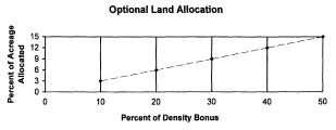
(D) The above table details additional density bonuses as specified in item (b) in Table A.
(i) Multiply the density bonus desired by 0.3 to calculate acreage allocation percent.
(ii) Density bonus shall not exceed fifty percent.
(iii) Acreage allocated shall not exceed fifteen percent of total acreage.
The maximum number of lots shall not exceed the maximum density provisions as outlined in the provisions of this section. The remainder of the property shall be held in open space to be preserved and maintained for its scenic value, recreation, conservation, or habitat purposes.
(6) A total residential project density bonus not to exceed two hundred percent of that allowed in the underlying zoning district is available for any planned development that commits itself to make available ten percent of the residential units to households earning eighty percent or less of the median household income for Chelan County. To qualify for this bonus the annual rent or payment, for the ten percent of the residential units, may not exceed twenty-eight percent of the median household income for Chelan County, adjusted for family size. The availability of these units shall be guaranteed by covenant, deed restriction or other legally binding mechanism for twenty years from the time of issuing the certificate of occupancy.
(7) Landscaping and/or Native Vegetation. It is the intent of this section to maintain and encourage landscaping design, innovation, and flexibility. The arrangement of plantings in conjunction with other landscape elements will vary according to the requirements of each project. Less formal grouping of materials, especially in rural areas, is encouraged to accomplish a more naturalized appearance and to avoid linear and visually rigid design. Such groupings must still accomplish the intended required buffering between incompatible uses. Native drought tolerant vegetation, in lieu of lawns, and other water conserving design techniques (xeriscape) are greatly encouraged.
(Note: All common open space within the development shall be appropriately landscaped and/or vegetated using native vegetation according to the landscaping plan submitted by the applicant and approved by the hearing examiner/administrator unless otherwise allowed by the authorizing resolution. Natural features that are to be preserved such as indigenous plant life, natural rock formations and riparian areas shall be shown on the landscaping plan.)
(8) Open Space.
(A) Maintenance and Ownership of Common Open Space. The applicant shall choose one or any combination of the following methods of administering common open space:
(i) Dedications of common open space to local public agencies, e.g., schools, cities, counties, utility purveyors, and/or libraries, are subject to the public agencies formal acceptance.
(ii) Establishment of an association or nonprofit corporation of all property owners or corporations within the project area to ensure ownership of and responsibility for perpetual maintenance of all common open space.
(iii) Retention of ownership, control and responsibility for maintenance of all common open space by the applicant. All privately owned common open space shall continue to conform to its intended use and remain as expressed in the site development plan by the inclusion in all deeds of appropriate restrictions to ensure that the common open space is permanently preserved according to the site development plan. Said deed restrictions shall run with the land and be for the benefit of present as well as future property owners in the planned unit development.
(B) Within a PUD, open space is required at a minimum rate of fifteen percent of the project site for residential developments and ten percent of the project site for commercial or industrial developments of the total area. Of the total area calculated for open space, one hundred percent must be usable open space.
(C) Usable Open Space. Land that may consist of, but not be limited to, any of the following:
(i) All other open space owned in common by all residents or owners in the PUD;
(ii) Open play areas; outdoor recreational facilities;
(iii) Pedestrian or bicycle paths;
(iv) Picnic areas with tables and benches;
(v) Gazebos, benches and other resident gathering areas;
(vi) Community gardens;
(vii) Active recreational use such as sport courts, tot lot with play equipment, open play area, outdoor recreation center;
(viii) Nature interpretive areas;
(ix) Flower gardens;
(x) Pedestrian trails and paths not adjacent to streets;
(xi) Agricultural uses (including pastures);
(xii) Critical areas, shorelines, and their required buffers; natural, historic, archeological sites or features;
(xiii) Site perimeter landscaping and other required landscape areas, outside of the rights-of-way;
(xiv) Unfenced stormwater detention/retention ponds.
(D) Open space shall not include any of the following:
(i) Lots, dwellings and associated private yards, outdoor storage areas, and building setback areas;
(ii) Public or private street right-of-way, including sidewalks and planter strips;
(iii) Parking lots, driveways and other areas of motor vehicle use.
(E) Where practicable, open space should be located contiguous to designated open space on adjacent properties.
(F) Open space shall be clearly identified according to the proposed use of the open space.
(G) Open space shall be protected by recorded covenants, which restrict use to those specified in the approved PUD site plan and provide for the maintenance of the open space in a manner which assures its continuing use for the intended purpose.
(H) Open space should be accessible by pathways or sidewalks from all lots within the PUD.
(I) Open space designed for children shall not be located adjacent to any street unless properly designed with fencing, located away from street edges and other provisions to ensure adequate child safety.
(9) Level of Service Standards. Planned development applications shall not be approved if the increased demand for public facilities and services would have the effect of reducing service capacities below locally adopted levels of service. (Res. 2006-44 (part), 4/4/06: Res. 2003-10, 1/21/03; Res. 2000-129 (part), 10/17/00).
11.76.100 Public hearing.
Public hearings for a planned unit development shall be processed in accordance with the applicable provisions outlined in Title 14, Development Permit Procedures and Administration, of the Chelan County Code, as amended. The hearing examiner may attach additional conditions to mitigate impacts on adjoining property, or the surrounding area. (Res. 2006-44 (part), 4/4/06: Res. 2000-129 (part), 10/17/00).
11.76.110 Modifications.
The hearing examiner or administrator may allow modifications to the application for a planned unit development to ensure that the intent of this chapter is accomplished.
(1) A substantial modification to the approved preliminary or final planned unit development plan shall only be approved by the hearing examiner through an amendment (change of condition) application to the preliminary approval. All modifications which are not minor shall be considered substantial.
(2) A minor modification to the preliminary or final planned unit development plan may be approved administratively. Minor modifications shall be consistent with the following requirements:
(A) The modifications shall be limited to minor shifting of the location of buildings, proposed streets, utility easements, or common open space.
(B) The minor modifications shall not:
(i) Enlarge the boundaries of the approved planned unit development plan.
(ii) Change the approved uses.
(iii) Change general location or amount of land devoted to a specific land use.
(iv) Increase the residential densities. (Res. 2006-44 (part), 4/4/06).
11.76.120 Required findings.
The hearing examiner’s decision to approve, deny or conditionally approve the final application shall be supported by, but not limited to, the following findings:
(1) That the applicant has adequately demonstrated that the proposal will achieve a public benefit as a result of deviations from the underlying zoning district, per the standards contained in Section 11.76.030;
(2) That all the requirements of the planned unit development overlay district have been met;
(3) That the application has demonstrated consistency with the comprehensive plan. (Res. 2006-44 (part), 4/4/06: Res. 2000-129 (part), 10/17/00. Formerly 11.76.110).
11.76.130 Subdivision requirements.
If the land or structures in a PUD are intended to be leased, sold, or transferred into two or more lots, parcels, or tracts, such a division shall proceed in compliance with the provisions of the Chelan County subdivision resolution, Title 12 of this code, and Chapter 58.17 RCW. Any such preliminary land division may be considered simultaneously with the planned development. (Res. 2006-44 (part), 4/4/06: Res. 2000-129 (part), 10/17/00).