


Chapter 11.86
GEOLOGICALLY HAZARDOUS AREAS OVERLAY DISTRICT (GHOD)
Sections:
11.86.030 Classification challenge.
11.86.040 Administrative review.
11.86.060 Performance standards.
11.86.065 Report preparer qualifications and criteria.
11.86.070 Geologic site assessment and geotechnical report requirements.
11.86.080 Whispering Pines geologically hazardous areas overlay district.
11.86.005 Purpose.
The purpose of the geologically hazardous overlay district is to reduce the risk to the health and safety of citizens by designating and regulating geologically hazardous critical areas consistent with the Growth Management Act and Chapter 365-190 WAC, Minimum Guidelines to Classify Agricultural, Forest, Mineral Lands and Critical Areas. (Res. 2021-96 (Exh. A), 7/27/21; Res. 2021-54 (Att. A), 5/4/21; Res. 2007-97 (part), 7/2/07).
11.86.010 Applicability.
The provisions of this chapter shall apply to any land use or development under county jurisdiction that is proposed to be located within designated geologically hazardous areas with the exception of residential footprint expansions less than fifty percent. Designated geologically hazardous areas include all areas classified as geologically hazardous areas under Section 11.86.020. (Res. 2021-54 (Att. A), 5/4/21; Res. 2011-86 (Att. A) (part), 10/4/11: Res. 2007-97 (part), 7/2/07: Res. 2000-129 (part), 10/17/00).
11.86.020 Classification.
Classification of each geologically hazardous area will be based upon the risk to development. The following categories shall be used:
(1) Known or Suspected Risk. Areas that are susceptible to one or more of the following types of hazards shall be classified as a geologically hazardous area with a known or suspected risk and shall require a geologic site assessment as described in Section 11.86.070:
(A) Erosion hazard areas identified by the U.S. Department of Agriculture Natural Resources Conservation Service Chelan County Soil Survey as either:
(i) Areas with a “very severe” erosion hazard; or
(ii) Areas with a “severe” erosion hazard where slopes are fifteen percent or steeper.
(B) Landslide hazard areas shall include areas potentially subject to mass wasting based on a combination of geologic, topographic and hydrologic factors. They include any areas susceptible to mass movement because of any combination of bedrock or soil characteristics, slope (gradient), slope aspect, rock or soil bedding and inclination or fractures or other geologic structure, hydrology, damage or removal of vegetative cover, or other factors. Examples of these may include, but are not limited to, the following:
(i) Sites that are located on or within two hundred fifty feet of areas of documented or historic landslides, including areas identified in geotechnical/geological reports, such as:
(a) Those areas delineated by the United States Department of Agriculture Natural Resources Conservation Service as having a “severe” limitation for building site development.
(b) Areas designated as landslides or mass wasting deposits on maps published by the United States Geological Survey or the Washington Department of Natural Resources Division of Geology and Earth Resources.
(c) Areas located on a landslide feature which has shown movement during the past ten thousand years or which is underlain or covered by mass wastage debris of that period.
(ii) Sites that are located on or within two hundred fifty feet from areas with all three of the following characteristics:
(a) Slopes steeper than fifteen percent; and
(b) Hillsides intersecting geologic contacts with a relatively permeable sediment overlying a relatively impermeable sediment or bedrock; and
(c) Springs or groundwater seepage.
(iii) Areas potentially unstable as a result of rapid stream incision, stream or channel migration, stream bank erosion, or undercutting by wave action.
(iv) Areas located in bottoms of narrow drainages and other confined channels including canyons, ravines, and gullies, and areas located on an alluvial fan, presently or potentially subject to inundation by debris flows or catastrophic flooding.
(v) Steep Slopes. Areas located within two hundred fifty feet from the base of any slope of forty percent or steeper with ten feet of relief or a talus slope or a a distance equal to the vertical height of the slope, whichever is greater.
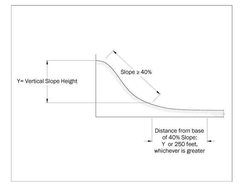
Figure 1. Steep slope classification.
(vi) Areas that have slopes of fifteen percent or steeper and are located within two hundred fifty feet from areas affected by wildfire within the past ten years, or areas within confined drainage channels downstream of recent wildfire areas.
(vii) Areas that show evidence of, or are at risk from, sliding that may pose a threat to the public health and safety.
(C) Seismic hazards. Sites that are located within areas mapped by Washington Department of Natural Resources as having liquefaction susceptibility of “moderate” or higher, and sites located within two hundred fifty feet from a mapped or inferred fault.
(D) Sites that are located on or within five hundred feet from snow avalanche areas. Snow avalanche areas include areas that show evidence of, or are at risk from, snow avalanches.
(E) Upon examination of the subject property by a qualified professional pursuant to Section 11.86.065, if a determination is made that none of the foregoing conditions are present on or adjacent to the property, the qualified professional may state in letter form the circumstances under which the site assessment or report may be waived.
(2) No Risk. Areas classified initially as geologically hazardous areas with a known or suspected risk or unknown risk may, upon further study, actually pose no risk to development or to the public health and safety. Where the administrator can determine that no risk from the geologically hazardous area is present, based upon geotechnical reports or best available science, these areas shall be classified as geologically hazardous areas determined to be of no risk.
(3) Unknown Risk. Geologically hazardous areas may be present in the county that cannot readily be identified based upon the criteria of subsection (1) of this section. Geologically hazardous areas of unknown risk include areas where data are not available to determine the presence or absence of a geological hazard. The administrator may require a geologic site assessment and/or geotechnical report to determine the actual presence or absence of a geologically hazardous area. (Res. 2021-54 (Att. A), 5/4/21; Res. 2007-97 (part), 7/2/07: Res. 2002-8 (part), 1/15/02: Res. 2000-129 (part), 10/17/00)
11.86.030 Classification challenge.
An applicant may challenge the geologically hazardous area classification determination made by the administrator. Said challenge shall be in the form of a geologic site assessment or a geotechnical report under the provisions of Section 11.86.070. If the geologic site assessment or a geotechnical report indicates that the geologically hazardous area does not exist or should be classified as no risk or low risk, the administrator may find that the performance standards outlined in this chapter do not apply to the site or project. (Res. 2021-54 (Att. A), 5/4/21; Res. 2007-97 (part), 7/2/07: Res. 2000-129 (part), 10/17/00).
11.86.040 Administrative review.
The administrator may modify the requirements of this chapter when existing or intervening natural or manmade features would preclude the development proposal from geologic risk. An applicant may request such review from the department of community development as part of the permit application process. (Res. 2021-54 (Att. A), 5/4/21; Res. 2007-97 (part), 7/2/07. Formerly 11.86.035).
11.86.050 Designation.
Areas classified as geologically hazardous areas pursuant to Section 11.86.020 are designated as geologically hazardous areas. (Res. 2021-54 (Att. A), 5/4/21; Res. 2007-97 (part), 7/2/07: Res. 2000-129 (part), 10/17/00. Formerly 11.86.040).
11.86.060 Performance standards.
(1) Upon completion of a geotechnical report, the following performance standards shall be applied during county review of proposed development projects that are the subject of the geotechnical report. Additional mitigation measures may be required pursuant to the findings of a geotechnical report. The administrator may agree to alternative mitigation measures set forth by the geotechnical report, if such alternative measures provide greater or equal protection than the application of the performance standards below. Development proposals may be approved pursuant to the performance standards of this section and/or mitigation measures of a geotechnical report, if they are determined to satisfy the purposes of this chapter. A development permit may be denied based upon the administrator’s evaluation of the inability of said measures to reduce risks associated with the geologically hazardous area. Performance standards to be utilized include:
(A) Construction methods should be used which minimize risks to structures and do not increase the risk to the site, or to adjacent properties and their structures, from the geologic hazard. Development shall not increase instability or create a hazard to the site or adjacent properties, or result in a significant increase in sedimentation or erosion.
(B) Site planning should minimize disruption of existing topography and vegetation, and should incorporate opportunities for phased clearing.
(C) Disturbed areas shall be replanted within one year of project completion, in accordance with an approved revegetation plan, and be appropriately bonded for.
(D) Impervious surface coverage shall be minimized.
(E) Excavation and grading shall be minimized. A clearing and grading schedule shall consider limitations based upon seasonal weather conditions.
(F) Detailed drainage plans may be required for projects affecting areas of geologic hazard. These plans shall indicate the effect the project may have on the hazard areas and adjacent properties and mitigating measures, with stormwater detention standards based upon the technical studies required under this document.
(G) Any limitations to site disturbance, such as clearing restrictions, imposed as a condition of development approval should be marked in the field and approved by the county prior to undertaking the project.
(H) A monitoring program should be prepared for construction activities occurring in geologic hazard areas and be marked on the face of the building permit.
(I) All authorized clearing for roads, utilities, etc., should be limited to the minimum necessary to accomplish engineering design. Alternatives should meet the following requirements:
(i) Clearing, grading, or filling of sloped sites containing erosion hazard areas shall be limited by weather conditions and an approved erosion control plan.
(ii) The face of cut and fill on slopes shall be prepared and maintained to control against erosion.
(J) Unless otherwise directed by the administrator or recommended in the site assessment or geotechnical report pursuant to Section 11.86.070, temporary erosion and sedimentation control shall be consistent with best management practices (BMPs) in the Stormwater Management Manual for Eastern Washington, as revised, pursuant to Chapter 13.16.
(K) To maintain the natural integrity of landslide hazard areas and to protect the environment, and the public health and safety, adequate vegetation shall be maintained around all sides of the landslide hazard area.
(L) Development proposals that involve altering land upon areas identified as landslide or avalanche hazard areas must demonstrate the following for approval:
(i) There is no evidence of recent landslides or avalanches in the vicinity of the proposed development and quantitative analysis of slope stability and/or other pertinent factors indicate no significant risk to the proposed development or nearby areas.
(ii) The landslide or avalanche hazard areas can be modified or the project can be designed so that the landslide or avalanche hazard to the project is eliminated.
(iii) Unless otherwise directed by the administrator or recommended in the geotechnical report pursuant to Section 11.86.070, surface water discharge from the site shall comply with requirements in the Stormwater Management Manual for Eastern Washington, as revised, pursuant to Chapter 13.16, and natural surface water drainages including water discharging from springs or seeps and shall be maintained.
(iv) Disturbance of trees and vegetation shall be the minimum necessary in order to prevent erosion and/or an increase in avalanche hazard, to stabilize slopes, and preserve the natural character of the area.
(v) Structures and improvements shall be located to preserve the most sensitive portion of the site and its natural landforms and vegetation.
(M) Projects in snow avalanche hazard areas shall provide technical studies, which identify the location and extent of the potential avalanche area and include mitigation measures, which ensure that the proposed activity will not increase the potential for an avalanche on the subject property and adjacent properties.
(2) Performance standards or mitigation measures outlined in a geologic site assessment or geotechnical report shall be implemented and incorporated into conditions of approval, if applicable.
(3) If performance standards or mitigation measures are outlined in a geologic site assessment or geotechnical report, an engineer or geologist shall verify that said measures/standards have been adequately completed and provide written notification of completion to the department. (Res. 2021-54 (Att. A), 5/4/21; Res. 2007-97 (part), 7/2/07: Res. 2002-8 (part), 1/15/02: Res. 2000-129 (part), 10/17/00).
11.86.065 Report preparer qualifications and criteria.
(1) A geologic site assessment, when required, shall be prepared by either a geologist licensed by the state of Washington; an engineering geologist licensed by the state of Washington; or a professional civil engineer with geologic expertise licensed by the state of Washington.
(2) A geotechnical report, when required, shall be prepared by either an engineering geologist licensed by the state of Washington or a professional civil engineer with geologic expertise licensed by the state of Washington. A civil engineer must also have the following experience and background.
(A) Five years of geotechnical experience evaluating geologically hazardous conditions and site development activities, such as landform recognition; unstable geologic units; roads; structural footings, foundations and retaining walls; swimming pools and sport courts; and other activities such as timber removal, site disturbance and mining. (Res. 2021-54 (Att. A), 5/4/21; Res. 2007-97 (part), 7/2/07).
11.86.070 Geologic site assessment and geotechnical report requirements.
Geologic site assessments and geotechnical reports shall be prepared in compliance with the following provisions. A geotechnical report contains all of the provisions of a geologic site assessment and shall be considered to meet the requirements of a geologic site assessment.
(1) The geologic site assessment shall include the following:
(A) Evaluate the actual presence of geologically hazardous areas within or in the vicinity of the site and the need for a geotechnical report. Specifically mention the circumstances or conditions which require the report to be prepared (steep slopes, erodible soils, suspected landslide or avalanche hazard, adverse hydrologic or flood risk, etc.).
(B) Evaluate safety issues related to proposed activities. Address issues that could involve personal injury, worksite safety, or property damage.
(C) Address existing geologic, topographic, and hydrologic conditions on the site, including an evaluation of the ability of the site to accommodate the proposed activity. Describe the proposed development, including property size and location, nature and extent of the planned development (i.e., house, garage, shop, swimming pool, etc.), and its specific location on the property. Include evidence of prior grading, excavation, cut banks, fill areas, or mining activity, and their potential impact on the project. Note and evaluate any features that could adversely affect development such as drainage gullies, erosion channeling, alluvial fans, evidence for debris flow or avalanche, surface creep and landslides observed or suspected spring activity and flood risk potential.
(D) A discussion of the surface and subsurface geological and engineering properties of the soils, sediments, and/or rocks on the subject property and adjacent properties and their effect on the stability of the slope. Note any areas of modified ground or fill. Where known from field inspection or reference maps and literature, include bedrock identification and age, bedding and joint attitude with respect to slope inclination, fracturing, faults and shear zones, hydrothermal alteration, weathering characteristics, presence of landslide deposits and its age and consolidation, etc. Use cross-sections if necessary for better representation of subsurface character.
(E) A description of the soils in accordance with the Unified Soil Classification System. Give general soil characteristics that could affect site development (i.e., frost action and shrink/swell potential, permeability, compressibility, density or consistency, plasticity and wet/dry behavior, erodibility, etc.). Especially note the presence or suspected presence of clay-rich horizons and their position/location in the soil profile, and any indication that a building site could be subjected to soil compression or differential setting.
(F) Evidence and history of avalanches, faults, significant geologic contacts, springs or seeps, landslides or other downslope soil movement, or sedimentation and alluviation, stream or channel or shoreline incision, migration, or erosion, on the subject property and adjacent properties not detailed in subsection (1)(C) of this section.
(G) A discussion of seismic hazards including seismic class, liquefaction susceptibility including probable depth to groundwater, fault rupture, ground shaking, slope failure, and settlement or subsidence.
(H) A summary of the site assessment and its conclusions, mentioning the presence or absence of geological hazards and site suitability. Determine the appropriate hazard category according to the classification of the geologically hazardous area consistent with Section 11.86.020. Include any recommendations for mitigation of potential hazards that can be dealt with without requiring a complete geotechnical report (control measures such as footing or intercept drainage systems, erosion control, debris catchment, vegetative management and restoration, and the probable need for engineering consultation and design). Include a recommendation whether additional study, including a geotechnical report pursuant to Section 11.86.070, is required.
(I) A topographic map showing the proposed development site location and approximate parcel shape location and boundaries.
(J) Provide a summary of readily available existing information for the site vicinity, including geological/geotechnical reports. Cite all references and information used in the assessment preparation, such as United States Geologic Survey (USGS) and Department of Natural Resources Geologic Maps and Bulletins, soil studies, surveys and previous reports.
(2) The geotechnical report determined to be required by the geologic site assessment shall include the following:
All of the information required for a geologic site assessment as well as the following:
(A) Determine the appropriate hazard category according to the classification of the geologically hazardous area consistent with Section 11.86.020.
(B) Evaluation of seismic hazards considering the proposed development.
(C) Determine the appropriate application of the performance standards of Section 11.86.060 and/or alternative mitigation measures that provide an equal or greater level of protection.
(D) Include a contour map of the proposed site, at a scale of one inch equals twenty feet or as deemed appropriate by the administrator. Slopes shall be clearly delineated for the ranges between fifteen and twenty-nine percent, and thirty percent or greater, including figures for a real coverage of each slope category on the site. When site-specific conditions indicate the necessity, the administrator may require the topographic data to be field surveyed.
(E) A site development plan drawn to scale which shows the boundary lines and dimensions of the subject property, the location, size and type of any existing or proposed structures, off-site structures or facilities that could be impacted, impervious surfaces, wells, drainfields, drainfield-reserve areas, roads, easements, and utilities proposed or located on site.
(F) The location of springs, seeps, or other surface expressions of groundwater. The location of surface water or evidence of seasonal surface water runoff or groundwater.
(G) The extent and type of vegetative cover prior to development activity or site disturbance.
(H) The proposed method of drainage and locations of all existing and proposed surface and subsurface drainage facilities and patterns, and the locations and methods for erosion control.
(I) An identification of any modified ground including fill areas and assessment of potential hazards or recommendations for mitigation.
(J) Information demonstrating compliance with all applicable codes and ordinances for the proposed development permit.
(K) Recommendations for vegetation management or restoration or whether a vegetation specialist is required for a management plan.
(3) Geologic site assessments and geotechnical reports, when completed in accordance with this chapter, shall be valid for a period of five years. A qualified professional, as outlined in Section 11.86.065(2), may extend the applicability of a valid geologic site assessment or geotechnical report by five years by submittal of a letter stating the validity of the existing document and its application for the extension; provided, that such letter must address any changes in surrounding land use activity or site conditions. (Res. 2021-54 (Att. A), 5/4/21; Res. 2007-97 (part), 7/2/07: Res. 2002-8 (part), 1/15/02; Res. 2000-129 (part), 10/17/00).
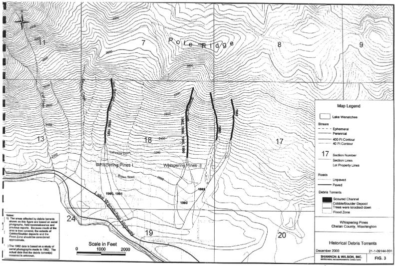
11.86.080 Whispering Pines geologically hazardous areas overlay district.
The following review criteria and standards shall apply to the Whispering Pines I subdivision, the area commonly known as Whispering Pines II and areas of influence as depicted and described on the Historical Debris Torrents Map, Figure #3 in the Whispering Pines Debris Torrent Hazard Study, Lake Wenatchee, Chelan County, Washington, submitted to Chelan County January 15, 2001, by Shannon and Wilson, Inc., Geotechnical and Environmental Consultants, excluding Sections 13 and 19. These requirements apply only to Sections 17 and 18 as depicted on Map Figure #3, Historical Debris Torrents.
On-site evidence as entered into the record by property owners questions the accuracy of the Shannon and Wilson study as it pertains to actual property lines, debris/torrent path(s) and associated channel(s). If an applicant’s site plan is inconsistent with the Map Figure #3, Chelan County staff will conduct an on-site visit to field confirm the dimensional accuracy of site plan.
The subject area is designated as a geologically hazardous area pursuant to the provisions of the Chelan County Code. Building and/or development permits may be issued in conformance with the following requirements:
(1) No building or development permits shall be issued for structures, development, activity or uses within the scoured channel(s) and cobble/boulder deposit as delineated on Map Figure #3, Historical Debris Torrents.
(2) The area designated as the flood zone on the Historical Debris Torrent Hazard Map, Figure #3, shall be referred to herein as “areas of potential geologic hazard.” Building or development permits may be issued in the “areas of potential geologic hazard” in conformance with the findings, recommendations, mitigations and requirements of a geologic site assessment pursuant to the requirements of this chapter.
(3) A hold harmless agreement (notice, acknowledgement, waiver, release and indemnification) on forms provided by the Chelan County department of building/fire safety and planning shall be required prior to the issuance of a building/development permit located within the “areas of potential geologic hazard.” The hold harmless agreement shall be recorded with the Chelan County auditor to run with the title to the land and shall also serve as a notice to title.
(4) A geologic site assessment will not be required for real property located within one thousand feet of the scoured channel(s), cobble/boulder deposits and “areas of potential geologic hazard” as delineated on Map Figure #3, except as may be required by subsection (5) of this section.
(5) A setback less than fifty feet from the top of the scoured channel will require a geologic site assessment in conformance with the requirements of this chapter.
(6) Geologic site assessments shall be prepared in conformance with this chapter and shall be signed and stamped by an engineering geologist or geotechnical engineer licensed by the state of Washington.
(Res. 2021-54 (Att. A), 5/4/21; Res. 2005-41, 4/5/05. Formerly 11.86.090).