


Appendix B
ICICLE DESIGN REVIEW GUIDELINES
Preface
The Icicle design review guidelines are intended to establish a design criterion for development activities specified in the Icicle Valley design review overlay district. Those development activities include road construction, clear-cuts and structural developments. Modifications to the existing natural environment should, as much as possible, repeat form, line, color and texture common to the surrounding landscape. Changes in the natural landscape can occur, but should remain visually subordinate to the surrounding environment. The Icicle Valley is recognized for its visual quality and each development should be evaluated on the site’s ability to accept alteration without losing its inherent visual character.
Design Criteria
(1) Single-Family Dwellings Outside an Existing Subdivision.
(A) Site Location.
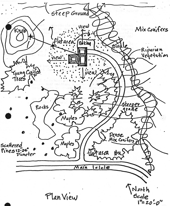
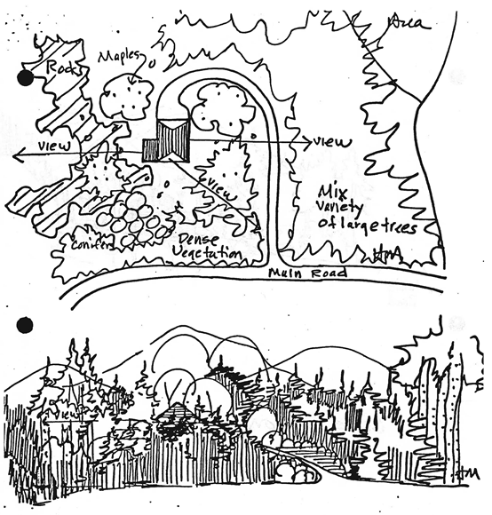
(i) Each individual site should utilize the best possible location in siting the structure. Existing timber stands and brush should be taken advantage of as much as possible for screening purposes.
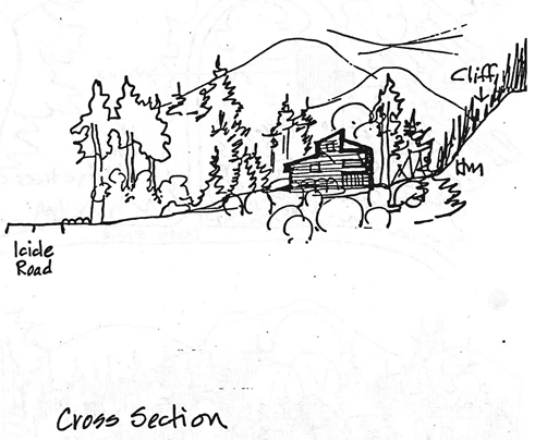
(ii) Natural topographic features such as benches, rock outcrops and any other unique land form should be utilized in the site selection. Structures located at the far edge of forest clearings should be placed far enough from the road that they become an integral part of the landscape rather than a dominant feature.
(iii) The structure should be oriented so that the gable end faces or is perpendicular to the primary road.
(B) Architectural Design.
(i) Structural design should emphasize vertical alignment through type of siding, roof line and architectural design which conforms with existing form, line, color and texture of the surrounding environment.
(ii) Natural earth tone colors should be utilized for siding, trim and metal roofing. Where possible, construction should utilize wood products or native materials (log construction, stone, etc.).
(iii) Broken rooflines with a steep pitch are encouraged for all residential structures.
(iv) Building heights shall conform to the underlying forest resource (FR) zoning district and/or the shoreline conservancy environment requirements.
(C) Vegetation.
(i) As much naturally occurring vegetation should be retained as construction allows. A natural vegetation buffer between the structure and road corridor or shoreline should be maintained to produce a filtered effect.
(ii) Introduced vegetation or landscaping should be native or native appearing. Exposed manicured lawns should be screened in such a fashion to blend with the natural landscape.
(iii) When the building site is visible from the primary road on-site grading should be kept to a minimum, and generally for construction purposes only. Artificial forms, such as cutbanks, earth mounds, rock or slash piles, should be avoided when grading, clearing, landscaping or locating driveways.
(iv) Other than the vegetation cleared for fire purposes, layering of vegetation around the building site by diversity of species and age classes is encouraged. Layering is accomplished by selective tree cutting to achieve a mixture of conifers with both mature overstories and understories, hardwoods, and dense shrubberies.
(D) Setbacks.
(i) Setback from road or shoreline should depend on density of vegetation, steepness of slope, and viewing distance.
(ii) Staggered setbacks from adjacent structures within viewing distance are encouraged. A natural vegetation buffer between those structures should be maintained.
(iii) Structures should be located to maintain sufficient tree canopy to minimize visual impact of structures from higher vantage points.
(E) Private Access Drives.
(i) Private drives serving more than one building site are encouraged. The number of private drives accessing the primary road should be limited.
(ii) While the approach of the access drive to the primary road should be at a right angle, curvilinear or winding driveways to the building site should be utilized; vegetation removal should only be done to accommodate the width of the driveway.
(iii) Grades for private drives should not exceed fourteen percent. Drain dips are encouraged in lieu of culverts where slopes permit, except at the intersection of a primary road.
(iv) A house identification number sign may be placed along Icicle Road for all residential structures. It will be constructed of natural materials such as wood or stone. Identification signs are to be eight by sixteen inches in size with a brown background in ivory numbers.
(F) Water Quality.
(i) Soil test holes may be required by the Chelan Douglas health district. These test holes may be required during the period of normal seasonal high-water runoff. Soil test results will be used to determine the degree of porosity of the soil, and the possible need for setbacks from surface water or wells of more than one hundred feet.
(ii) Complete plans for septic tank and acceptable water system shall be submitted with all applications.
(G) Fire Protection.
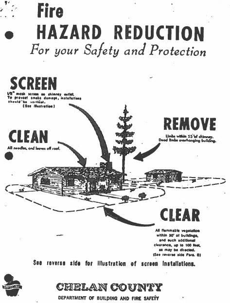
(i) On-site firefighting provisions are for the initial attack of the structure and the surrounding forest environment.
(ii) Site preparation for fire protection normally requires the removal of all fine forest fuels or a thirty-foot radius around the primary structure. Specifically, fine forest fuels include all weeds and combustible debris (except for small scattered ornamentals). Also, trees within one hundred feet of the primary residence should be thinned so that the crowns do not touch each other and should be pruned of all dead limbs and debris within ten feet off the ground.
(iii) All single-family residences shall have a cistern, well, or pond with five-hundred-gallon minimum storage capacity. Also, a powered pumping system shall be provided for each residence which can reasonably produce eighteen gallons per minute for a thirty-minute duration.
(iv) Enough fire hose should be available to reach a one hundred-foot radius around the primary structure. The pump should be able to deliver a minimum of fifty pounds of pressure at the nozzle at the highest elevation of the one-hundred-foot radius.
(v) The pumping system should have at least a one-inch port, with a four to five horsepower engine which will develop approximately one hundred pounds of pressure. This is not to discourage the utilization of a gravity flow type of system.
(vi) The water storage facility should be designed to be functional and operable during the normal forest service firefighting season.
(vii) The water pumping system should be located at least thirty feet from the structure or in a position such that access to the pump is protected in the event of structural fire.
(viii) All structural chimneys shall be equipped with an approved spark arrestor and all tree branches within fifteen feet of the chimney shall be removed.
ICICLE DESIGN REVIEW GUIDELINES
FIRE PROTECTION
On-site firefighting provisions are for the initial attack of the structure and the surrounding forest environment.
(1) Site preparation for fire protection shall require the removal of all fine forest fuels for a thirty-foot radius around the primary structure. Specifically, the fine forest fuels include all weeds and combustible debris with the exception of small scattered ornamentals.
In addition, trees within one hundred feet of the primary residence should be thinned so that the crowns do not touch each other and should be pruned of all dead limbs and debris within ten feet of the ground.
(2) All single-family residences shall have a cistern, well, or pond with five-hundred-gallon minimum storage capacity. Also, a powered pumping system shall be provided for each residence which can reasonably produce eighteen gallons per minute for a thirty-minute duration. The pumping system should have at least a one-inch port, with a four to five horsepower engine which will develop approximately one hundred pounds of pressure. The pump should be able to deliver a minimum of fifty pounds of pressure at the nozzle at the highest elevation of use.
The water pumping system should be located at least thirty feet from the structure or in a position such that access to the pump is protected in the event of structural fire.
Enough fire hose should be available to reach a one-hundred-foot radius around the primary structure. (Contact Leavenworth ranger district for availability of fire hose.)
The water storage facility and pumping system shall be functional during the normal firefighting season.
Note: A gravity system which can meet the pressure requirements can be approved.
(3) All structural chimneys shall be equipped with an approved spark arrestor (no greater than a one-half-inch opening) and all tree branches within fifteen feet of the chimney shall be removed (see illustration on next page).
ICICLE VALLEY ACCESS ROAD DESIGN GUIDELINES
Statement of Intent
It is the intent of these guidelines to ensure the protection of the natural environment, water quality and visual character of the valley while providing specific design and construction standards for private access roads. The elements contained in these guidelines are intended to produce access roads which are functional and safe, with the least amount of visual environmental impacts.
(1) Location Criteria. Publicly and privately owned lands in the Icicle Valley are recognized for their inherent visual character and quality. The natural landscape of the Icicle Valley is considered distinctive and possesses a high degree of visual quality. Retention of the valley’s scenic corridor is one of the Icicle design review committee’s highest priorities. In order to insure the scenic integrity of the valley is protected, the following locational criteria will be used to evaluate each road proposal:
(A) Access roads should only be located where the least amount of environmental and visual disturbance will occur.
(B) Natural topographic features such as ridge lines, swales, outcrops and natural vegetation features should be used in screening the access road’s appearance.
(C) Modified or disturbed slopes which are evident may require some degree of mitigation. Possible mitigating measures may include: reducing the size of exposed cuts and fills, removal of waste excavation material, shaping of barrow areas, reshaping of existing or abandoned roads, retaining large rocks or outcrops in slope cutouts, spreading topsoil and forest duff on disturbed soils, feathering of cleared areas, and possibly revegetation.
(D) The proposed road location should indicate that the best possible location has been selected based on the area’s existing topography, number of parcels being served, exposure to the primary road and distance from the primary road.
(2) Design Criteria. The road design portion of the guidelines will address the actual mechanics of road construction. The type of road proposals the committee will review should be intended for passenger cars and service vehicles, with adequate turnouts and curvature radius.
(A) Grade.
(i) Minimum of two percent.
(ii) Maximum of fifteen percent.
(B) Width.
(i) Minimum of twelve feet wide.
Due to forest service requirements a double lane approach or turnout will be required as the private road intersects with the primary forest service road. Other critical turnouts should be required and installed at the design review committee’s discretion and on the recommendation of the county engineering staff.
(C) Surfacing. A minimum of a hard-packed dirt surface will be required. Each access road proposal will require the submittal of a road maintenance agreement for the design review committee’s review.
(D) Drainage. The use of drain dips should be encouraged where natural topography permits. Drain dip spacing should generally be five hundred feet unless natural topography dictates otherwise. When grades exceed ten percent, culverts may be required.
(E) Site Clearing. Site clearing in most instances should be limited to the edge of the designed grading manipulation area. As much naturally occurring vegetation should be retained as construction allows. One hundred percent removal of slash and other excavation waste will be required.
(F) Other Miscellaneous Design Features. The county engineer will provide the design review committee with technical assistance concerning the evaluation of cuts, fills, curvature, turnout location and width, alignment, drainage feasibility, retaining structures and other general design features.
(3) Applicability. Each access road proposal must meet the minimum design standards specified in the design criteria of the guidelines. Also, each road proposal must demonstrate that sensitive viewing areas have been preserved through proper road location. The road location should fit the natural landscape and result in minimal on-site modifications. Existing or abandoned logging roads which require no new alterations are encouraged to be used as access roads to potential building sites. Substandard existing roads shall be improved to the minimum design standards. New road construction which visually disturbs the landscape may require mitigation as stated in section (1)(C) of the guidelines. The method and extent of mitigation will be determined by the design review committee based on the locational criteria. Mitigating measures may be included as a condition of approval for each access road application.
In order for the design review committee to adequately evaluate each road proposal, the applicant shall submit a contour map which details the proposed road alignment, proposed building sites, all site modifications, significant land features and vegetational characteristics of the area. The contour map shall also indicate any wet or inundated areas and the proposed location of drain dips and drainage culverts. To evaluate road gradient, a typical road profile and cross section will also be required. Applicants are encouraged to provide support information in the form of photographs, slides, sketches and written narratives which support the proposed road location. (Res. 2021-91, 7/20/21).