


Chapter 17.85
RESOURCE LANDS AND CRITICAL AREAS
Sections:
17.85.030 Relationship to other regulations.
17.85.044 Private property rights.
17.85.050 Application process.
17.85.060 Reference maps and inventories.
17.85.080 Mitigation, maintenance, monitoring and contingency.
17.85.090 Best available science.
17.85.100 Critical area review process.
17.85.130 Critical areas – Fish and wildlife conservation.
17.85.140 Critical areas – Geologically hazardous.
17.85.150 Critical areas – Aquifer recharge and wellhead protection areas.
17.85.160 Critical areas – Wetlands.
17.85.170 Critical areas – Frequently flooded areas.
17.85.010 Intent and purpose.
The intent and purpose of this chapter is to designate, classify and protect the functions and values of critical areas in a manner consistent with state law while allowing for reasonable use of private property and to provide for reasonable protection of the natural environment, resource lands and the general public health, safety and welfare, and satisfy the requirements of RCW 36.70A.060 by:
(1) Establishing standards to protect critical areas;
(2) Protecting the general public, resources and facilities from injury, loss of life, property damage or financial loss due to flooding, landslides, or steep slope failure;
(3) Protecting unique, fragile and valuable elements of the environment including, without limitation, wildlife and its habitat;
(4) Meeting the requirements of the National Flood Insurance program and maintaining the city of Clarkston as an eligible community for federal flood insurance benefits;
(5) Preventing cumulative adverse environmental impacts on water availability, water quality, groundwater, wetlands, rivers and streams;
(6) Providing appropriate guidance and protection measures for addressing the needs and concerns associated with resource lands and critical areas that help define the quality of life in the city of Clarkston;
(7) Encouraging the retention of open space and development of recreational opportunities, conserving fish and wildlife habitat, and increasing access to natural resource lands and water;
(8) Implementing applicable mandated federal and state regulations; and
(9) Best available science will be used where appropriate in determining appropriate measures to protect the functions and values of critical areas and for the preservation or enhancement of anadromous fisheries.
By adopting this section, the city of Clarkston acknowledges that critical areas provide a variety of important biological and physical functions that benefit the community and its residents or may pose a threat to human safety or property. [Ord. 1470, 2010; Ord. 1382, 2004. Code 1966 § 17.20.010.]
17.85.020 Applicability.
The provisions of this chapter shall apply to all development activities within the incorporated city of Clarkston. Any development authorized to alter the condition of any land, water or vegetation; or to alter or construct any building, structure or improvement shall be in compliance with the requirements of this chapter. When the provisions of this chapter are in direct conflict with each other or with other federal or state regulations, the provision that is the most restrictive shall apply. The public works director shall have broad authority and discretion to determine appropriate restrictions as applied by this chapter on existing lots of record for all development activity.
All regulatory or administrative actions taken pursuant to this chapter shall not result in an unconstitutional taking of private property, and shall not expand or reduce the scope of private property protections provided in the state and federal constitutions. This chapter shall not prohibit uses legally occurring prior to its adoption. Classifying or designating resource lands and critical areas does not imply a change in the landowner’s right to use his or her land under current law. [Ord. 1470, 2010; Ord. 1382, 2004. Code 1966 § 17.20.020.]
17.85.030 Relationship to other regulations.
These critical areas regulations shall apply as an overlay and in addition to zoning and other regulations adopted by the city of Clarkston. Any individual critical area adjoined by another type of critical area shall have the buffer and meet the requirements that provide the most protection to the critical areas involved. When any provision of this chapter or any existing regulation, easement, covenant, or deed restriction conflicts with this chapter, that which provides more protection to the critical areas shall apply. [Ord. 1470, 2010; Ord. 1382, 2004. Code 1966 § 17.20.030.]
17.85.040 Exemptions.
The activities enumerated below are exempt from the provisions of this chapter. The final determination of whether an activity is exempt is a function of the administrator.
(1) Normal maintenance or repair of existing buildings, structures, roads or development, including damage by accident, fire or natural elements. Normal repair of buildings and structures involves restoring to a state comparable to the original condition including the replacement of walls, fixtures and plumbing; provided, that the value of work and materials in any 12-month period does not exceed 25 percent of the value of the structure prior to such work as determined by the county assessor, the repair does not expand the number of dwelling units in a residential building, the building or structure is not physically expanded, and, in the case of damaged buildings and structures, a complete application for repair is accepted by the city of Clarkston within six months of the event and repair is completed within the terms of the permit;
(2) Emergency construction necessary to protect property from damage by the elements. An emergency is an unanticipated event or occurrence which poses an imminent threat to public health, safety, or the environment, and which requires immediate action within a time too short to allow full compliance. Once the threat to the public health, safety, or the environment has dissipated, the construction undertaken as a result of the previous emergency shall then be subject to and brought into full compliance with this chapter;
(3) The normal maintenance and repair of culverts and bridges that does not involve the use of heavy equipment, and that does not require permit issuance from other local, state or federal agencies. [Ord. 1470, 2010; Ord. 1382, 2004. Code 1966 § 17.20.040.]
17.85.042 Reasonable use.
“Reasonable use” means the minimum use to which a property owner is entitled under applicable state and federal constitutional provisions, including takings and substantive due process. Reasonable use shall be liberally construed to protect the constitutional property rights of the applicant. A reasonable use exemption may only be secured by using the city’s conditional use process.
A reasonable use exemption may be secured only if:
(1) The strict application of the CAO would deny reasonable use of the property.
(2) There is no other reasonable use that would result in less impact on the critical area.
(3) Any alterations permitted to the critical area shall be the minimum necessary to allow for reasonable use of the property.
(4) The inability to derive reasonable economic use is not the result of the applicant’s actions or that of a previous property owner, such as by segregating or dividing the property and creating an undevelopable condition.
(5) Any alteration of a critical area approved under this section shall be subject to appropriate conditions and will require mitigation under an approved mitigation plan.
Classifying, inventorying, and designating lands does not imply a change in a landowner’s right to use his or her land under current law. The law requires that natural resource land uses be protected from land uses on adjacent lands that would restrict resource production. Development regulations adopted to protect critical areas may limit some land development options. [Ord. 1640 § 1, 2020; Ord. 1470, 2010.]
17.85.044 Private property rights.
Private property shall not be taken for public use without just compensation having been made. The property rights of landowners shall be protected from arbitrary and discriminatory actions. The city shall evaluate proposed regulatory or administrative actions to assure that such actions do not result in an unconstitutional taking of private property. [Ord. 1470, 2010.]
17.85.050 Application process.
The flow chart below illustrates the process for review of a development application. The requirements for risk assessment and impact reports, mitigation plans, and other special reports are set forth in the following sections.
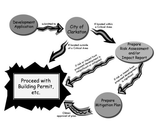
[Ord. 1470, 2010; Ord. 1382, 2004. Code 1966 § 17.20.050.]
17.85.060 Reference maps and inventories.
The distribution of critical areas within the city of Clarkston are described and displayed in reference materials and on maps maintained by the city of Clarkston. These reference materials, in the most current form, are intended for general information only and do not depict site-specific designations. They are intended to advise the city of Clarkston, applicants and other participants in the development permit process that a resource land or critical area may exist and that further study, review and consideration may be necessary. These reference materials shall include but are not limited to the following:
(1) Maps.
(a) City of Clarkston identified critical areas maps;
(b) Flood Insurance Rate Maps (1978);
(c) U.S. Fish and Wildlife Service National Wetlands Inventory, as amended;
(d) U.S.G.S. 7.5 Minute Series Topographic Quadrangle Maps; and
(e) WDFW Priority Habitats and Species and Wildlife Heritage Maps and Data, 2001, as amended.
(2) Documents.
(a) City of Clarkston comprehensive plan (latest version).
(b) Natural Resources Conservation Service Soil Survey – Asotin County.
(c) Management Recommendations for Washington’s Priority Habitats and Species, May 1991, as amended.
(d) Management Recommendations for Washington’s Priority Habitats – Riparian, December 1997, as amended.
(e) Priority Habitats and Species List, July 1999, as amended.
(3) City of Clarkston Maps. The approximate location and extent of city critical areas are shown on the adopted critical area maps. These maps are to be used as a guide for the city, project applicants, and/or property owners, and may be continuously updated as new critical areas are identified. They are a reference and do not provide a final critical area designation. [Ord. 1470, 2010; Ord. 1382, 2004. Code 1966 § 17.20.060.]
17.85.070 Disclosure.
The presence of any known or suspected critical areas on or within 100 feet of property that is the subject of a development permit shall be identified by the applicant in the application materials submitted to the city of Clarkston. [Ord. 1470, 2010; Ord. 1382, 2004. Code 1966 § 17.20.070.]
17.85.080 Mitigation, maintenance, monitoring and contingency.
(1) Mitigation, maintenance, monitoring and contingency plans shall be submitted by the developer to protect resource lands, critical areas and their buffers prior to the commencement of any development activities. Said plans shall be approved prior to any development activities.
(2) The property owner shall be responsible for reporting to the city of Clarkston and undertaking appropriate corrective action when monitoring reveals a significant deviation from predicted impacts or a failure of mitigation or maintenance measures. [Ord. 1470, 2010; Ord. 1382, 2004. Code 1966 § 17.20.080.]
17.85.090 Best available science.
(1) “Best available science” means current scientific information used in the process to designate, protect, or restore critical areas that is derived from a valid scientific process as defined by WAC 365-195-900 through 365-195-925. Critical area reports and decisions to alter critical areas shall rely on the best available science to protect the functions and values of critical areas and must give special consideration to conservation or protection measures necessary to preserve or enhance anadromous fish, such as salmon and bull trout, and their habitat.
(2) The best available science is that scientific information applicable to the critical area prepared by local, state, or federal natural resource agencies, a qualified scientific professional, or team of qualified scientific professionals that is consistent with criteria established in WAC 365-195-900 through 365-195-925. [Ord. 1640 § 2, 2020; Ord. 1470, 2010; Ord. 1382, 2004. Code 1966 § 17.20.090.]
17.85.100 Critical area review process.
If a proposed development is within, or could be within, a designated critical area, the developer shall file an application with the city of Clarkston.
(1) As part of the review process, the city shall:
(a) Verify the information submitted by the applicant;
(b) Evaluate the project area and vicinity for critical areas;
(c) Determine whether the proposed project is likely to impact the functions or values of critical areas; and
(d) Determine if the proposed project adequately addresses the impacts and avoids impacts to the critical area associated with the project.
(2) If the proposed project is within, adjacent to, or is likely to impact a critical area, the city shall:
(a) Require a critical area report from the applicant that has been prepared by a qualified professional;
(b) Review and evaluate the critical area report;
(c) Determine whether the development proposal conforms to the purposes and performance standards of this chapter;
(d) Assess the potential impacts to the critical area and determine if they can be avoided or minimized; and
(e) Determine if any mitigation proposed by the applicant is sufficient to protect the functions and values of the critical area and public health, safety, and welfare concerns consistent with the goals, purposes, objectives, and requirements of this chapter.
(3) Decision on Identification Form.
(a) No Critical Areas Present. If, after a site visit, the public works director’s analysis indicates that the project area is not within or adjacent to a critical area or buffer and that the proposed activity is unlikely to degrade the functions or values of a critical area, then the public works director shall rule that the critical area review is complete and note on the identification form the reasons that no further review is required. A summary of this information shall be included in any staff report or decision on the underlying permit.
(b) Critical Areas Present, But No Impact – Waiver. If the public works director determines that there are critical areas within or adjacent to the project area, but that the best available science shows that the proposed activity is unlikely to degrade the functions or values of the critical area, the public works director may waive the requirement for a critical area report. A waiver may be granted if there is substantial evidence that all of the following requirements will be met:
(i) There will be no alteration of the critical area or buffer;
(ii) The development proposal will not impact the critical area in a manner contrary to the purpose, intent, and requirements of this chapter; and
(iii) The proposal is consistent with other applicable regulations and standards.
A summary of this analysis and the findings shall be included in any staff report or decision on the underlying permit.
(c) Critical areas may be affected by proposal. If the public works director determines that a critical area or areas may be affected by the proposal, then the public works director shall notify the applicant that a critical area report must be submitted prior to further review of the project, and indicate each of the critical area types that should be addressed in the report.
(4) The city requires applicants to demonstrate that development on a site determined to have critical areas will protect the resource by taking one of the following steps (listed in order of preference):
(a) Avoid impacts to the resource altogether.
(b) Minimize the impact by limiting the degree or magnitude of the action and its implementation by using appropriate technology, or by taking affirmative steps to avoid or reduce impacts.
(c) Rectify the impact by repairing, rehabilitating or restoring the affected environment to the conditions existing at the time of the initiation of the project.
(d) Reduce or eliminate the impact over time by preservation and maintenance operations during the life of the action.
(e) Compensate for the impact by replacing, enhancing or providing substitute resources or environments. [Ord. 1470, 2010; Ord. 1382, 2004. Code 1966 § 17.20.100.]
17.85.110 Special reports.
In order to maintain and protect critical areas, as well as to assist in classifying and designating such areas, site-specific environmental information will be required when evaluating a development proposal.
(1) Special reports shall be submitted for review and approval in conjunction with development applications when required by the review authority. Each chapter dealing with a specific resource or critical area contains a description of when special reports may be required.
(2) When no other application review process is required, final special reports shall be reviewed and approved pursuant to city of Clarkston ordinances.
(3) The preparation of special reports or tests required by this chapter is the responsibility of the applicant for a development permit. Costs incurred by the city of Clarkston to engage technical consultants or for staff review and interpretation of data and findings submitted by or on behalf of the developer or applicant shall be reimbursed by the applicant in accordance with a schedule adopted by the building department.
(a) Drainage and Erosion Control Plan. During project development the following standards apply:
(i) All drainage and erosion control plans shall be prepared by an engineer or other qualified person as approved by the city of Clarkston.
(ii) All drainage and erosion control plans shall address methods to minimize and contain soil within the project boundaries during construction and to provide for stormwater drainage from the site and its surroundings during and after construction.
(iii) All drainage and erosion control plans shall be prepared using the Type 2 SCS model, taking into account a storm event equal to or exceeding two inches of rainfall in 90 minutes.
(b) Geotechnical Report.
(i) All geotechnical reports shall be prepared by a civil engineer licensed to practice in the state of Washington.
(ii) A geotechnical report shall include a description of the geology of the site, conclusions and recommendations regarding the effect of geologic conditions on the proposed development, and opinions and recommendations on the suitability of the site to be developed.
The report shall evaluate the actual presence of geologic conditions giving rise to the geologic hazard, and an evaluation of the safety of the proposed project, and identification of construction practices, monitoring programs and other mitigation measures necessary. A bibliography of scientific citations shall be included as necessary.
(iii) The city of Clarkston may waive the requirement for the report if, in his/her opinion, the proposed development would not cause significantly adverse geological impacts, or there is adequate geological information available on the area proposed for development to determine the impacts of the proposed development and appropriate mitigating measures.
(c) Grading and Excavation Plan. All grading and excavation plans shall be prepared by a civil engineer licensed to practice in the state of Washington, and it shall contain the following information:
(i) A cover sheet showing the general vicinity and specific location of work, the name and address of the owner and the licensed civil engineer who prepared the plans;
(ii) Property limits and accurate contours of existing ground and details of terrain and area drainage;
(iii) Limits of proposed excavation and fill sites, finished contours and proposed drainage systems and/or facilities, including an estimated runoff served by the systems and/or facilities;
(iv) Location of any buildings or structures on the property where the work is to be performed and the location of any buildings or structures on land of adjacent owners which are within 15 feet of the property;
(v) Recommendations included in any soils engineering report and/or an engineering geology report shall be incorporated in the grading plans or specifications. [Ord. 1470, 2010; Ord. 1382, 2004. Code 1966 § 17.20.110.]
17.85.114 Record of notice.
(1) All critical areas, once identified, shall be recorded on all documents of title of record for all affected property.
(2) Notification. Property owners with land adjacent to identified critical areas must be notified of critical area buffers on their lands.
(3) Signing. The outer perimeter of identified critical areas shall be clearly marked throughout construction to ensure that no unauthorized intrusion will occur prior to the commencement of permitted activities. The administrative official may require permanent signs with specific and appropriate wording be installed along the boundary of a critical area as a condition of any permit or approval. [Ord. 1470, 2010.]
17.85.116 Performance bonds.
When a performance bond or other surety instrument is attached as a condition of approval to a development permit, or any mitigation associated with a development permit, the applicant shall be required to post a monetary amount determined to be acceptable by the city in addition to the following requirements:
(1) The amount shall be 125 percent of the estimated cost of uncompleted actions or the estimated cost of restoring the functions and values of the critical area that is at risk, whichever is greater.
(2) Depletion or collection of bond funds shall not discharge the applicant’s or violator’s obligation to complete any required mitigation, maintenance, monitoring, or restoration.
(3) Public development proposals shall be exempt from this section if public funds have previously been committed for mitigation, maintenance, monitoring, or restoration.
(4) Failure to satisfy any provisions attached to a development permit under the terms of this chapter shall constitute a default and authorize the city to demand payment of any financial guarantees.
Any funds recovered pursuant to this section shall be used to complete the required mitigation or other required actions. [Ord. 1470, 2010.]
17.85.120 Resource lands.
The city of Clarkston has no identified or designated lands which are classified as agricultural resource, forest resource, or mineral resource lands. “Natural resource lands” means agricultural, forest and mineral resource lands which have long-term commercial significance. [Ord. 1470, 2010; Ord. 1382, 2004. Code 1966 § 17.20.120.]
17.85.130 Critical areas – Fish and wildlife conservation.
City of Clarkston has identified or designated lands which are classified as fish and wildlife conservation areas. Uses and activities allowed within designated fish and wildlife conservation areas are those uses permitted by the zoning district, subject to the provisions of this chapter. Governing standards and criteria addressing uses and activities, as well as bulk, height and dimensional standards within the incorporated areas of city of Clarkston, are found in the city of Clarkston zoning ordinance.
(1) Classification.
(a) All fish and wildlife conservation areas shall be identified and classified by city of Clarkston to reflect the relative function, value and uniqueness of the habitat area as established through an approved habitat ranking evaluation (see subsection (3) of this section) submitted by the applicant for any development permit. City of Clarkston may use the information sources in CMC 17.85.050 as guidance in identifying the presence of potential fish and wildlife habitat conservation areas and the subsequent need for a habitat boundary survey along with an on-site inspection, if necessary.
(b) Fish and wildlife habitat conservation areas include:
(i) Areas in which endangered, threatened, and sensitive species have a primary association;
(ii) Habitats and species of local importance;
(iii) Naturally occurring ponds under 20 acres and their submerged aquatic beds that provide fish or wildlife habitat;
(iv) Waters of the state;
(v) Lakes, ponds, streams, and rivers planted with game fish by a governmental or tribal entity; or
(vi) State natural area preserves and natural resource conservation areas.
(c) “Fish and wildlife habitat conservation areas” are areas that serve a critical role in sustaining needed habitats and species for the functional integrity of the ecosystem, and which, if altered, may reduce the likelihood that the species will persist over the long term. These areas may include, but are not limited to, rare or vulnerable ecological systems, communities, and habitat or habitat elements including seasonal ranges, breeding habitat, winter range, and movement corridors; and areas with high relative population density or species richness. Counties and cities may also designate locally important habitats and species. “Fish and wildlife habitat conservation areas” is amended to reflect statutory amendment in 2012 to RCW 36.70A.030 to “not include such artificial features or constructs as irrigation delivery systems, irrigation infrastructure, irrigation canals, or drainage ditches that lie within the boundaries of, and are maintained by, a port district or an irrigation district or company.”
(2) Designation. All existing areas of the city of Clarkston identified on the critical areas map are designated as fish and wildlife habitat conservation areas.
(3) Habitat Boundary Survey.
(a) A wildlife habitat boundary survey and evaluation shall be conducted by a fish or wildlife biologist, as appropriate, who is knowledgeable of wildlife habitat, within southeastern Washington. The wildlife habitat boundary shall be field staked by the biologist and surveyed by a land surveyor for disclosure on all final plats, maps, etc.
(b) The public works director may waive the requirement for the survey for minor development if:
(i) The proposed development is not within the extended proximity of the associated habitat;
(ii) There is adequate information available on the area proposed for development to determine the impacts of the proposed development and appropriate mitigating measures; and
(iii) The applicant provides voluntary deed restrictions that are approved by the public works director.
(c) The wildlife habitat boundary and any associated buffer shall be identified on all plats, maps, plans and specifications submitted for the project.
(4) Fish/Wildlife Habitat Management and Mitigation Plan.
(a) A fish/wildlife habitat management and mitigation plan shall be prepared by a biologist who is knowledgeable of wildlife habitat within southeastern Washington.
(b) The fish/wildlife habitat management and mitigation plan shall demonstrate, when implemented, that there is no net loss of the ecological function of the habitat.
(c) The fish/wildlife habitat management and mitigation plan shall identify how impacts from the proposed project shall be mitigated, as well as the necessary monitoring and contingency actions for the continued maintenance of the habitat conservation area and any associated buffer.
(d) The fish/wildlife habitat management and mitigation plan shall contain a report containing, but not limited to, the following information:
(i) Location maps of appropriate scales;
(ii) A map or maps indicating the boundary of the habitat conservation areas; the width and length of all existing and proposed structures, utilities, roads, easements; wastewater and stormwater facilities; adjacent land uses, zoning districts and comprehensive plan designations;
(iii) A description of the proposed project including the nature, density and intensity of the proposed development and the associated grading, structures, roads, easements, wastewater facilities, stormwater facilities, utilities, etc., in sufficient detail to allow analysis of such land use change upon the habitat conservation area;
(iv) A detailed discussion of surface and subsurface hydrologic features both on and adjacent to the site where the review authority determines appropriate;
(v) A description of the vegetation in the habitat conservation area, on the overall project site and adjacent to the site;
(vi) A detailed description of the proposed project’s effect on the habitat conservation area, and a discussion of any federal, state or local management recommendations which have been developed for the species or habitats in the area;
(vii) A discussion of the following mitigation alternatives as they relate to the proposal:
(A) Avoiding the impact altogether by not taking a certain action or parts of an action;
(B) Minimizing impacts by limiting the degree or magnitude of the action and its implementation, by using appropriate technology, or by taking affirmative steps to avoid or reduce impacts;
(C) Rectifying the impact by repairing, rehabilitating or restoring the affected environment;
(D) Compensating for the impact by replacing, enhancing, or providing substitute resources or environments;
(viii) A plan by the applicant which explains how any adverse impacts created by the proposed development will be mitigated, including without limitation the following techniques:
(A) Establishment of buffer zones;
(B) Preservation of existing plants and trees;
(C) Limitation of access to the habitat conservation area;
(D) Seasonal restriction of construction activities;
(E) Establishment of a timetable for periodic review of the plan;
(ix) A detailed discussion of ongoing management practices which will protect the habitat conservation area after the project site has been fully developed, including proposed monitoring, contingency, maintenance and surety programs. All reports will be provided in a professional and legible format;
(x) Application Requirements. Development permit applications shall provide appropriate information on forms provided by the review authority, including without limitation the information described below.
Additional reports or information to identify potential impacts and mitigation measures to fish and wildlife habitat conservation areas may be required if deemed necessary.
Projects within a fish or wildlife habitat conservation area or its buffer shall provide the following information:
(A) The location and dimensions of all existing and proposed buildings, roads and other improvements, and their physical relationship to the habitat conservation area;
(B) The location and type of any proposed buffers, including the identification of any other protective measures;
(C) Habitat boundary survey and evaluation findings of the qualified consultant;
(D) Habitat management and mitigation plan;
(E) A drainage and erosion control plan;
(F) A grading and excavation plan;
(xi) General Standards. The following minimum standards shall apply to all development activities occurring within designated habitat conservation areas and their associated buffers.
(A) Habitat conservation areas will be left undisturbed, unless the development proposal involves appropriate mitigation and enhancement measures, as determined on a site-specific basis.
(B) Habitat Conservation Areas. Development occurring within a 1,000-foot radius of a state or federal threatened, endangered, or sensitive species den, nesting, or breeding site, migration corridors or feeding areas of terrestrial species shall require a habitat management and mitigation plan.
(C) Appropriate buffer areas shall be maintained between all permitted uses and activities and designated habitat conservation areas.
1. All buffers shall be measured from the habitat edge, as established by the approved habitat boundary survey.
2. All buffer areas shall be temporarily fenced between the construction activity and the buffer with a highly visible and durable protective barrier during construction to prevent access and protect the designated habitat conservation area and associated buffer. The review authority may waive this requirement if an alternative to fencing which achieves the same objective is proposed and approved.
3. Except as otherwise allowed, buffers shall be retained in their natural condition. Any habitat created, restored or enhanced as compensation for approved habitat alterations shall have the standard buffer required for the category of the created, restored or enhanced habitat.
4. The width of the buffer may be increased by the review authority for a development project on a case-by-case basis when a larger buffer is necessary to protect the designated habitat conservation area function and value. The determination shall be based on site-specific and project-related conditions, which include without limitation:
a. The designated habitat conservation area is used for feeding, nesting and resting by species proposed or listed by the federal or state government as endangered, threatened, sensitive, candidate, monitor or critical; or if it is an outstanding potential habitat for those species or has unusual nesting or resting sites such as heron rookeries or raptor nesting trees;
b. The adjacent land is susceptible to severe erosion and erosion control measures will not effectively prevent adverse habitat impacts;
c. The proposed development adjacent to the designated habitat conservation area would be a high intensity land use.
5. Standard buffer widths may be modified by the review authority for a development proposal by averaging buffer widths based on a report, submitted by the applicant and prepared by a qualified professional approved by the public works director (e.g., wildlife biologist), and shall only be allowed where the applicant demonstrates all of the following:
a. Averaging is necessary to avoid an extraordinary hardship to the applicant caused by circumstances peculiar to the property;
b. The designated habitat conservation area contains variations in sensitivity due to existing physical characteristics;
c. The width averaging will not adversely impact the designated habitat conservation area’s functional value;
d. The total area contained within the buffer after averaging is no less than that contained within the standard buffer prior to averaging;
e. Off-site mitigation is required if the buffer area is smaller than normally required in order to accommodate small lot sizes or other special conditions;
(xii) Specific Standards. The following standards shall apply to the activity identified below, in addition to the general standards above.
(A) Road Repair and Construction. When no other practical alternative exists, public or private road or repair, maintenance, expansion or construction may be authorized within a designated habitat conservation area, subject to the following minimum standards:
1. The road shall serve multiple properties;
2. No significant adverse impacts to the designated habitat conservation area shall result from the repair, maintenance, expansion or construction of any public or private road;
3. The road shall provide for the location of public utilities, pedestrian or bicycle easements, viewing points, etc.; and
4. Road repair and construction is the minimum necessary to provide safe traveling surfaces.
(B) All developments within a designated habitat conservation area shall comply with the following minimum standards:
1. A habitat management and mitigation plan shall be required for developments within or containing habitat conservation areas.
2. Designated habitat conservation areas and their associated buffers created within habitat management or mitigation plans shall be delineated and disclosed on final plats, maps, documents, etc., as critical area tracts, nonbuildable lots, buffer areas or common areas. Ownership and control may be transferred to a homeowner’s association or designated as an easement or covenant encumbering the property;
(xiii) Specific Habitats. In addition to general performance standards required herein, the following standards shall be required for specific habitat conservation areas:
(A) Endangered, threatened, and sensitive species.
(B) No development shall be allowed within a habitat conservation area or buffer with which state or federal endangered, threatened, or sensitive species have a primary association.
(C) Approval for alteration of land adjacent to a habitat conservation area or its buffer where endangered, threatened, and sensitive species have a primary association shall not occur prior to consultation with the state Department of Fish and Wildlife and the appropriate federal agency.
(D) Bald eagle habitat shall be protected pursuant to the Washington State Bald Eagle Protection Rules, WAC 232-12-292, and any activity proposed within 800 feet, or within 2,640 feet and in a shoreline foraging area, of a verified nest territory or communal roost shall include a habitat management plan developed by a qualified professional. The habitat management plan shall be approved by the state Department of Fish and Wildlife prior to any final permit approvals;
(xiv) Anadromous Fish. Conservation or protection measures necessary to preserve or enhance anadromous fisheries include measures that protect habitat important for all life stages of anadromous fish, including, but not limited to, spawning and incubation, juvenile rearing and adult residence, juvenile migration downstream to the sea, and adult migration upstream to spawning areas. Special consideration should be given to habitat protection measures based on the best available science relevant to stream flows, water quality and temperature, spawning substrates, instream structural diversity, migratory access, estuary and nearshore marine habitat quality, and the maintenance of salmon prey species. All activities, uses, and alterations proposed to be located in water bodies used by anadromous fish or in areas that affect such water bodies shall, at a minimum, adhere to the following standards:
(A) Activities shall be timed to occur only during the allowable work window as designated by the state Department of Fish and Wildlife for the applicable species.
(B) Alternative alignments or location for the activity is determined to be nonfeasible.
The activity is designed so that it does not degrade the functions and values of the fish habitat or other critical areas. Any impacts to the functions and values of the habitat conservation area shall be mitigated in accordance with an approved critical areas report mitigation plan. [Ord. 1640 §§ 3, 3.1, 2020; Ord. 1470, 2010; Ord. 1382, 2004. Code 1966 § 17.20.130.]
17.85.140 Critical areas – Geologically hazardous.
The city of Clarkston has identified or designated lands which are classified as geologically hazardous. Geologically hazardous areas are areas that, because of their susceptibility to erosion, sliding, earthquake, or other geological events, are not suited to siting commercial, residential, or industrial development consistent with public health or safety concerns. Uses and activities allowed within designated geologically hazardous areas are those uses permitted by the zoning district, subject to the provisions of this chapter. Governing standards and criteria addressing uses and activities, as well as bulk, height and dimensional standards within the incorporated areas of the city of Clarkston are found in the city of Clarkston zoning ordinance.
(1) Classification.
(a) All geologically hazardous areas shall be classified by the city of Clarkston according to the level of risk associated with the hazardous area as established through an approved geologic hazard risk assessment and/or a geotechnical report submitted by the applicant in accordance with this chapter. The city of Clarkston may use on-site inspections and the information sources identified in CMC 17.85.060 as guidance in identifying the presence of potential geologically hazardous areas.
(b) Geologically hazardous areas in the city of Clarkston shall be classified according to the following system:
(i) Known or suspected risk;
(ii) No risk;
(iii) Risk unknown.
(c) Any land containing soils, geology or slopes that meet any of the following criteria shall be classified as having a known or suspected risk of being geologically hazardous areas:
(i) Areas identified by the United States Department of Agriculture Natural Resources Conservation Service as having a slope greater than 25 percent and including these two soil types: Dallesport very cobbly sandy loam, 30 to 60 percent slopes, and Chard loam, 25 to 40 percent slopes.
(ii) Areas potentially subject to landslides based on a combination of geologic, topographic, and hydrologic factors. They include any areas susceptible because of any combination of bedrock, soil, slope (gradient), slope aspect, structure, hydrology, or other factors. Examples of these may include, but are not limited to, the following:
(A) Areas of historic failures, such as:
1. Those areas delineated by the United States Department of Agriculture Natural Resources Conservation Service as having a “severe” limitation for building site development;
2. Those areas mapped as Class U (unstable), UOS (unstable old slides), and URS (unstable recent slides) in the Department of Ecology coastal zone atlas; or
3. Areas designated as quaternary slumps, earthflows, mudflows, or landslides on maps published as the United States Geological Survey or Department of Natural Resources division of geology and earth resources.
(B) Areas with all three of the following characteristics:
1. Slopes steeper than 15 percent; and
2. Hillsides intersecting geologic contacts with a relatively permeable sediment overlying a relatively impermeable sediment or bedrock; and
3. Springs or groundwater seepage;
(C) Areas potentially unstable as a result of rapid stream incision, stream bank erosion, and undercutting by wave action;
(D) Any area with a slope of 45 percent or steeper and with a vertical relief of 10 or more feet except areas composed of consolidated rock. A slope is delineated by establishing its toe and top and measured by averaging the inclination over at least 10 feet of vertical relief;
(E) Areas subject to severe risk of damage as a result of earthquake induced ground shaking, slope failure, settlement, soil liquefaction, or surface faulting.
(2) Designation. All existing areas of the city of Clarkston identified on the critical areas map are designated as geologically hazardous areas.
(3) Determination Process – Geologically Hazardous Areas. The city of Clarkston shall review each development permit application to determine if the provisions of this chapter shall be initiated. In making the determination, the city of Clarkston may use any resources identified in CMC 17.85.060, as well as any previously completed special reports conducted in the vicinity of the subject proposal. The following progressive steps shall occur upon a determination by the city of Clarkston that a geologically hazardous area may exist on a site proposed for a development permit:
(a) Step One. The city of Clarkston staff shall determine if there is any possible geologically hazardous areas on site designated by subsection (2) of this section. This determination shall be made following a review of information available and a site inspection if appropriate. If no hazard area is determined to be present, this chapter shall not apply to the review of the proposed development.
(b) Step Two. If it is determined that a geologically hazardous area may be present, the applicant shall submit a geologic hazard area risk assessment prepared by an engineer or a geologist. The risk assessment shall include a description of the geology of the site and the proposed development; an assessment of the potential impact the project may have on the geologic hazard; an assessment of what potential impact the geologic hazard may have on the project; appropriate mitigation measures, if any; and a conclusion as to whether further analysis is necessary. The assessment shall be signed by and bear the seal of the engineer or geologist that prepared it. No further analysis shall be required if the geologic hazard area risk assessment concludes that there is no geologic hazard present on the site, nor will the project affect or be affected by any potential geologic hazards that may be nearby.
(c) Step Three. If the professional preparing the risk assessment in step two concludes that further analysis is necessary, the applicant shall submit a geotechnical report consistent with the provisions of CMC 17.85.080. The geotechnical report shall include a certification from the engineer preparing the report, including the engineer’s professional stamp and signature, stating all of the following:
(i) The risk of damage from the project, both on and off site, is minimal;
(ii) The project will not materially increase the risk of occurrence of the hazard; and
(iii) The specific measures incorporated into the design and operational plan of the project to eliminate or reduce the risk of damage due to the hazard.
All mitigation measures, construction techniques, recommendations and technical specifications provided in the geotechnical report shall be applied during the implementation of the proposal. The engineer of record shall submit sealed verification at the conclusion of construction that development occurred in conformance with the approved plans. A proposed development cannot be approved if it is determined by the geotechnical report that either the proposed development or adjacent properties will be at risk of damage from the geologic hazard, or that the project will increase the risk of occurrence of the hazard, and there are no adequate mitigation measures to alleviate the risks. [Ord. 1470, 2010; Ord. 1382, 2004. Code 1966 § 17.20.140.]
17.85.150 Critical areas – Aquifer recharge and wellhead protection areas.
The city of Clarkston has identified or designated no lands which are classified as aquifer recharge areas. Areas with a critical recharging effect on aquifers used for potable water are areas where an aquifer that is a source of drinking water is vulnerable to contamination that would affect the potability of the water.
The city of Clarkston has identified or designated lands which are classified as wellhead protection areas. Uses and activities permitted within designated aquifer recharge areas and wellhead protection areas are those that are authorized in the applicable zoning district, subject to the provisions of this chapter. Governing standards and criteria addressing uses and activities, as well as bulk, height and dimensional standards, within the incorporated areas of the city of Clarkston are found in the city of Clarkston zoning ordinance.
(1) Classification. All wellhead protection areas shall be classified by the city of Clarkston as any area located within the 10-year capture zone identified by the Asotin County PUD No. 1 wellhead protection map.
(2) Designation. All existing areas of the city of Clarkston classified as stated in subsection (1) of this section are hereby designated as wellhead protection areas.
(3) Application Requirements. Development permit applications shall provide appropriate information on forms provided by the review authority. Additional special reports or information to identify potential impacts and mitigation measures to wellhead protection areas may be required if deemed necessary by the city of Clarkston.
(4) General Standards. The following minimum standards shall apply to all development activities occurring within designated wellhead protection areas.
(a) Development activities within a wellhead protection area shall be designed, developed and operated in a manner that will not potentially degrade the city of Clarkston groundwater resources.
(b) Any changes in land use or type of new facilities where substances of moderate risk are used, stored, treated or handled, or which produce moderate risk waste, shall be designed to prevent the release of any such materials into the groundwater.
(c) The following uses and activities shall be prohibited within a designated wellhead protection area:
(i) The conversion of heating systems to fuel oil or the installation of new fuel oil heating systems.
(ii) Accumulation of junk materials.
(iii) Hazardous substance treatment, storage and disposal facilities.
(iv) The negligent transportation of hazardous substances and/or materials.
(v) Solid waste and inert debris landfills, transfer stations, and/or recycling facilities.
(vi) Petroleum product pipelines.
(vii) Class I, II, III, IV and V underground injection wells, except 5D2 storm drainage wells, 5G30 special drainage wells and 5R21 aquifer recharge wells as identified by the federal Safe Drinking Water Act.
(viii) Mineral extraction.
(ix) Landfills, including hazardous waste, municipal solid waste, special waste, wood waste, inert waste, and demolition waste.
(x) Underground injection wells of Classes I, III, and IV and subclasses 5F01, 5D03, 5F04, 5W09, 5W10, 5W11, 5W31, 5X13, 5X14, 5X15, 5W20, 5X28, and 5N24 of Class V wells.
(xi) Mining of Metals and Hard Rock. Sand and gravel mining shall also be prohibited from critical aquifer recharge areas rated as highly susceptible or vulnerable.
(xii) Wood treatment facilities that allow any portion of the treatment process to occur over natural or manmade permeable surfaces.
(xiii) Facilities that store, process, or dispose of radioactive substances.
(xiv) Activities that would significantly reduce the recharge to aquifers currently or potentially used as a potable water source.
(xv) Activities that would significantly reduce the recharge to aquifers that are a source of significant baseflow to a regulated stream.
(xvi) Activities that are not connected to an available sanitary sewer system in areas associated with sole source aquifers.
(5) Specific Standards. The following standards shall apply to the activity identified below, in addition to the general standards outlined above.
(a) Aboveground Storage Tanks or Vaults. Construction of an aboveground storage tank or vault, regardless of the storage capacity, for the storage of moderate substances or dangerous wastes as defined by Chapter 173-303 WAC may be authorized subject to the following standards:
(i) The design of the storage tank or vault shall include an impervious containment area enclosing or underlying the tank which is large enough to contain 120 percent of the volume of the tank.
(ii) Leak and release detection equipment shall be installed on all tanks and vaults.
(b) Underground Storage Tanks and Vaults. Construction of an underground storage tank or vault, regardless of the storage capacity, for the storage of moderate substances or dangerous wastes as defined by Chapter 173-303 WAC may be authorized subject to the following standards:
(i) The design of the storage tank or vault shall include an impervious containment area enclosing or underlying the tank which is large enough to contain 120 percent of the volume of the tank.
(ii) All storage tanks and vaults shall either be cathodically protected against corrosion, constructed of noncorrosive materials, or steel clad with noncorrosive materials.
(iii) The lining of all tanks and vaults shall be compatible to the substance to be stored.
(iv) Leak and release detection equipment shall be installed on all tanks and vaults.
(c) Stormwater Standards and Requirements for 5D2 Stormwater Drainage Wells, 5G30 Special Drainage Wells, and 5R21 Aquifer Recharge Wells as Identified by the Federal Safe Drinking Water Act.
(i) Soil Infiltration.
(A) Infiltration rates less than 2.4 inches per hour shall construct and maintain a pre-settling basin prior to discharge.
(B) Infiltration rates greater than or equal to 2.4 inches per hour shall provide water quality treatment using best management practices (BMPs) prior to discharging to unsaturated soils.
(ii) Detention facilities shall be designed to reduce peak discharge and improve water quality.
(A) Detention volumes are represented by the area between the pre-developed and developed hydrograph for the city design storm. The minimum required to be retained in the detention basin before outfall to a stormwater drywell shall not exceed a volume for a six-month 24-hour storm.
(B) Inlet and outlet placements shall be placed as far apart as possible to minimize short-circuiting of the facility.
(C) All detention basins shall have an emergency overflow so the facility will not be damaged if runoff is exceeded.
(iii) “Vegetated filter areas” are vegetated channels that allow overland flow which effectively treats stormwater runoff.
(A) Flow depths shall not exceed six inches in depth and the preferred slope is two to four percent. Check dams with a six- to 12-inch vertical drop shall be installed for slopes of four to six percent.
(B) The minimum length shall not be less than two linear feet.
(C) The maximum cross section shall not exceed three horizontal units to one vertical unit (3:1).
(D) The site shall be improved with a vegetative cover suitable for the filter area. Vegetation shall be permanently maintained in a manner acceptable to the administrator.
(iv) Operation and Maintenance.
(A) The inlet flow spreader shall be kept free of leaves, rocks and other debris.
(B) Biofilters planted in grasses shall be mowed regularly to promote growth and pollutant uptake.
(C) Biofilters shall be periodically checked and sediments shall be removed by hand whenever sedimentation covers vegetation or begins to reduce the biofilter’s capacity. Damaged areas shall be reseeded.
(d) Surface Impoundments. Surface impoundments, defined by Chapter 173-303 WAC, shall be designed by a professional engineer and constructed with an impermeable liner and other components as appropriate to prevent discharge of any material on the ground surface and/or into the groundwater system. Surface impoundments shall be designed and constructed in accordance with applicable governing law, and have a minimum excess capacity equal to 120 percent of the projected volume of liquid to be contained including intentional and unintentional stormwater capture.
(e) Developments. All developments proposed within a wellhead protection area shall comply with the following standards:
(i) Connection to a public sanitary sewer system or an approved community sewer system shall be required. If connection to sanitary sewer is not feasible, on-site septic systems proposed on lots of record legally existing on the date this chapter was enacted or legally created after this chapter was enacted are permitted, provided:
(A) The public health officer has designated the wellhead protection area as an area of special concern in accordance with WAC 246-272-20501.
(B) The type of on-site system is approved by the county health district upon finding that the design of the system will not be detrimental to the community water supply.
(C) The property owner shall enter a no protest agreement with the city of Clarkston sewer district, or other sanitary sewer provider as appropriate to the property location, agreeing to not protest the formation of a local improvement district for the extension of sanitary sewer. This agreement shall be recorded with the city of Clarkston auditor.
(D) The connection to an approved public water service shall be required.
(E) All existing wells located on the subject property shall either be properly abandoned in accordance with the requirements of the county health district and the Department of Ecology or designated for irrigation purposes only. If an existing well is designated for irrigation purposes, then the following shall apply:
1. Evidence of a water right issued by the state of Washington for the use of the well shall be presented to the review authority. An application for a water right is not acceptable evidence of an actual right to appropriate water.
2. Certification from the public health officer stating that the well is properly constructed and sealed to prevent any contaminants from entering the wellhead shall be submitted to the review authority.
(ii) Stormwater detention and retention facilities shall be designed using best available science and management practices to separate chemical and biological pollutants from the water prior to infiltration. The use of injection wells is prohibited.
(iii) An analysis shall be conducted to assess the impact to groundwater quality from the potential of nitrate loading to the groundwater.
(iv) Areas highly susceptible to transporting contaminants to the groundwater (i.e., natural drainages, springs, wetlands, etc.), as determined by the city of Clarkston, shall be designated as open space. All impervious surfaces shall maintain a 15-foot setback from areas identified as being highly susceptible and no amount of stormwater runoff shall be directed towards the susceptible area(s).
(f) Parks, Schools, Golf Courses, and Recreation Facilities. Fertilizer and pesticide management practices of schools, parks, other recreation facilities and similar uses shall use best management practices as prescribed by the Washington State University Cooperative Extension Services.
(g) All major and minor developments shall have an informational note placed on the face of the plat stating this subdivision is located within a wellhead protection area. Best management practices shall be used for the containment of stormwater and the application of pesticides and fertilizers. [Ord. 1470, 2010; Ord. 1382, 2004. Code 1966 § 17.20.150.]
17.85.160 Critical areas – Wetlands.
The city of Clarkston has identified or designated no lands which are classified as wetlands. “Wetland” or “wetlands” means areas that are inundated or saturated by surface water or groundwater at a frequency and duration sufficient to support, and that under normal circumstances do support, a prevalence of vegetation typically adapted for life in saturated soil conditions.
(1) The following is included to provide for a possible designated wetland in the future:
“Wetland” or “wetlands” means areas that are inundated or saturated by surface water or groundwater at a frequency and duration sufficient to support, and that under normal circumstances do support, a prevalence of vegetation typically adapted for life in saturated soil conditions. Wetlands generally include swamps, marshes, bogs, and similar areas. Wetlands do not include those artificial wetlands intentionally created from nonwetland sites, including, but not limited to, irrigation and drainage ditches, grass-lined swales, canals, detention facilities, wastewater treatment facilities, farm ponds, and landscape amenities, or those wetlands created after July 1, 1990, that were unintentionally created as a result of the construction of a road, street, or highway. Wetlands may include those artificial wetlands intentionally created from nonwetland areas created to mitigate conversion of wetlands.
“Qualified professional” for wetlands should be a professional wetland scientist with at least two years of full-time work experience as a wetlands professional, including delineating wetlands using the state or federal manuals, preparing wetland reports, conducting function assessments, and developing and implementing mitigation plans.
A wetland containing features satisfying the criteria of more than one of the following categories shall be classified in the highest applicable category. A wetland can be classified into more than one category when distinct areas that clearly meet the criteria of separate categories exist. The following categories are consistent with the Washington State Wetland Rating System for Eastern Washington: 2014 Update (Washington State Department of Ecology Publication No. 14-06-030, Olympia, WA, October 2014) and the approved federal wetland delineation manual and applicable regional supplements. These documents contain the definitions and methods for determining if the criteria below are met:
|
Wetland Category |
Description |
|---|---|
|
Category I |
Category I wetlands are: (1) alkali wetlands; (2) wetlands of high conservation value that are identified by scientists of the Washington Natural Heritage Program/DNR; (3) bogs and calcareous fens; (4) mature and old-growth forested wetlands over 1/4 acre with slow-growing trees; (5) forests with stands of aspen; and (6) wetlands that perform many functions very well (scores between 22 and 27 points). These wetlands are those that (1) represent a unique or rare wetland type; or (2) are more sensitive to disturbance than most wetlands; or (3) are relatively undisturbed and contain ecological attributes that are impossible to replace within a human lifetime; or (4) provide a high level of function. |
|
Category II |
Category II wetlands are: (1) forested wetlands in the floodplains of rivers; (2) mature and old-growth forested wetlands over 1/4 acre with fast-growing trees; (3) vernal pools; and (4) wetlands that perform functions well (scores between 19 and 21 points). These wetlands are difficult, though not impossible, to replace, and provide high levels of some functions. These wetlands occur more commonly than Category I wetlands but still need a relatively high level of protection. |
|
Category III |
Category III wetlands have a moderate level of functions (scores between 16 and 18 points). These wetlands can be often adequately replaced with a well-planned mitigation project. Wetlands scoring between 16 and 18 points generally have been disturbed in some ways and are often less diverse or more isolated from other natural resources in the landscape than Category II wetlands. |
|
Category IV |
Category IV wetlands have the lowest level of functions (scores less than 16 points) and are often heavily disturbed. These are wetlands that we should be able to replace, and in some cases be able to improve. However, experience has shown that replacement cannot be guaranteed in any specific case. These wetlands may provide some important functions and also need to be protected. |
(2) Development near wetlands shall observe the following setbacks from the edge of the wetland. No development or activity shall occur within the required setbacks unless the applicant can demonstrate that the proposed use or activity will not degrade the functions and values of the wetland and other critical areas according to the evaluation criteria from subsection (5) of this section. In no case shall any development or activity be permitted closer to the edge of the wetland than within one-half of the required setback.
|
Wetland Category |
Setback |
|---|---|
|
Category I |
250 feet |
|
Category II |
200 feet |
|
Category III |
150 feet |
|
Category IV |
50 feet |
(3) Buffer zones may be increased if the city council finds, on a case-by-case basis and based upon best available science, at least one of the following applies:
(a) A larger buffer is necessary to maintain viable populations of existing species; or
(b) The wetlands are used by species proposed or listed by the federal government or the state as endangered, threatened, rare, sensitive or being monitored as habitat for those species or unusual nesting or resting sites; or
(c) The adjacent land is susceptible to severe erosion and erosion control measures will not effectively prevent adverse wetland impacts; or
(d) The adjacent land has minimal vegetative cover or slopes greater than 25 percent.
(4) Buffer zones may be decreased to no less than 25 feet if the city council finds, on a case-by-case basis and based upon best available science, that all of the following apply:
(a) The critical area report provides a sound rationale for a reduced buffer; and
(b) The existing buffer area is well-vegetated with native species and has less than 10 percent slopes; and
(c) No direct or indirect, short-term or long-term adverse impact to the wetland will result from the proposed activity.
(5) Wetland buffer areas may be used for conservation and restoration activities, passive recreation (including pedestrian trails, wildlife viewing structures and fishing access areas) and stormwater management facilities. Pedestrian trails in wetlands or buffers should be limited to permeable surfaces no more than five feet in width. Trails should not be permitted in wetlands except for minor crossings that minimize impact. They should be located only in the outer 25 percent of a wetland buffer, and should be designed to avoid removal of significant trees.
(6) If activities result in the loss or degradation of a regulated wetland or buffer, a mitigation or enhancement plan prepared by a qualified expert shall be submitted for review and approval by the city. Any mitigation or replacement wetland shall be located in the same watershed as the impacted wetland(s) of the same category and shall comply with the following ratios (new wetland area to that impacted by the proposal):
|
Wetland Category |
Mitigation Ratio |
|---|---|
|
Category I |
6:1 |
|
Category II |
3:1 |
|
Category III |
2:1 |
|
Category IV |
1.5:1 |
Monitoring should occur for at least five years from the date of plant installation and 10 years where woody vegetation (forested or shrub wetlands) is the intended result. [Ord. 1640 § 4, 2020; Ord. 1470, 2010; Ord. 1382, 2004. Code 1966 § 17.20.160.]
17.85.170 Critical areas – Frequently flooded areas.
The city of Clarkston has identified or designated lands which are classified as frequently flooded areas. “Frequently flooded areas” are lands in the floodplain subject to a one percent or greater chance of flooding in any given year. These areas include, but are not limited to, streams, rivers, lakes, coastal areas, wetlands, and areas where high groundwater forms ponds on the ground surface. Uses and activities permitted within designated frequently flooded areas and wellhead protection areas are those that are authorized in the applicable zoning district, subject to the provisions of this chapter. Governing standards and criteria addressing uses and activities, as well as bulk, height and dimensional standards within the incorporated areas of city of Clarkston are found in the city of Clarkston zoning ordinance.
(1) Classification. All frequently flooded areas shall be classified by the city of Clarkston as any area located within the A zone of the flood hazard boundary map (FHBM)/flood insurance rate map (FIRM) map.
(2) Designation. All existing areas of the city of Clarkston shown on the critical area map are hereby designated as frequently flooded areas.
(3) Application Requirements. Development permit applications shall provide appropriate information on forms provided by the review authority. Additional special reports or information to identify potential impacts and mitigation measures to frequently flooded areas may be required if deemed necessary by the city of Clarkston.
(4) General Standards. The following minimum standards shall apply to all development activities occurring within designated frequently flooded areas.
(a) Development activities within a frequently flooded area shall be designed, developed and operated in a manner that will not potentially degrade the city of Clarkston groundwater resources.
(b) All development and structures within frequently flooded areas shall have their design and construction methods certified by an engineer registered for practice in the state. The certification shall ensure that the structure will be able to resist all potential lateral forces, that the development and structure will not result in any increase in flood levels or soil erosion, and that the design meets all building code requirements and all city, state and federal requirements applicable to these special hazard areas.
(5) Specific Standards. The following standards shall apply to the activity identified below, in addition to the general standards outlined above.
(a) Anchoring. All new construction, buildings which are substantially improved, manufactured buildings and mobile homes in the flood hazard area must be anchored to prevent flotation, collapse or lateral movement of the structure.
(b) Construction Materials and Methods. All construction in the flood hazard area shall use materials and utility equipment which is resistant to flood damage and shall be installed using methods and practices that minimize flood damage. Electrical, heating, ventilation, plumbing, air conditioning equipment and other service facilities shall be located so as to prevent water from entering or accumulating within the components during floods.
(c) Utilities. All water supply and sanitary sewer systems shall be installed to eliminate infiltration of floodwater into the water system and minimize infiltration into or discharges from the sewer system.
(d) Floor Level. The lowest floor must be above the base flood elevation. Fully enclosed areas below the base flood elevation are not permitted.
(e) Encroachments. No development, substantial redevelopment or expansion of existing structures including fill, structures or other artificial obstructions or encroachments is permitted in floodways. [Ord. 1640 § 5, 2020; Ord. 1470, 2010; Ord. 1382, 2004. Code 1966 § 17.20.170.]
17.85.180 Administration.
The public works director or his/her designee shall have the authority and duty to administer the provisions of this chapter. The city may adopt, and revise as required, such instructions, policies and forms as are necessary to carry out the provisions of the applicable titles. [Ord. 1470, 2010; Ord. 1382, 2004. Code 1966 § 17.20.180.]
17.85.190 Variances.
Variances from the standards of this chapter may be authorized by the city in accordance with the procedures set forth in the city of Clarkston zoning ordinance. [Ord. 1470, 2010; Ord. 1382, 2004. Code 1966 § 17.20.190.]
17.85.200 Fees.
(1) The city of Clarkston by resolution shall establish fees for filing of a critical area identification form, critical area review processing, and other services provided by the city as required by this chapter. These fees shall be based on the anticipated sum of direct costs incurred by the city for any individual development or action and may be established as a sliding scale that will recover all of the city costs including the enforcement of these code provisions. Basis for these fees shall include, but not be limited to, the cost of engineering and planning review time, cost of inspection time, costs for administration, and any other special costs attributable to the critical area review process.
(2) Unless otherwise indicated in this chapter, the applicant shall be responsible for the initiation, preparation, submission, and expense of all required reports, assessment(s), studies, plans, reconnaissance(s), peer review(s) by qualified consultants, and other work prepared in support of or necessary to review the application. [Ord. 1470, 2010; Ord. 1382, 2004. Code 1966 § 17.20.200.]
17.85.210 Effective date.
This amendment to the zoning ordinance shall become effective five days from and after its passage and approval and such publication as may be required by law. [Ord. 1470, 2010; Ord. 1382, 2004. Code 1966 § 17.20.210.]