


Chapter 15.12
CRITICAL AREAS*
Sections:
Article I. General Provisions
15.12.020 Authority and applicability.
15.12.030 Relationship to other regulations.
15.12.040 Administrative procedures.
15.12.080 Jurisdiction—Critical areas.
15.12.090 Protection of critical areas.
15.12.100 Best available science.
15.12.120 Exception—Reasonable use.
15.12.130 General review process.
15.12.160 Mitigation requirements.
15.12.170 Mitigation sequencing.
15.12.180 Mitigation plan requirements.
15.12.190 Innovative mitigation.
15.12.200 Unauthorized critical area alterations and enforcement.
15.12.210 Critical area markers and signs.
15.12.220 Native growth habitat areas.
15.12.240 Bonds to ensure mitigation, maintenance, and monitoring.
15.12.250 Critical area inspections.
Article II. Wetlands
15.12.310 Designation, rating, delineating, and mapping wetlands.
15.12.320 Regulated activities.
15.12.330 Activities allowed in wetlands.
15.12.335 Activities allowed in wetland buffers.
15.12.340 Wetlands report—Additional requirements.
15.12.350 Performance standards—General requirements.
15.12.360 Performance standards—Specific activities and uses.
15.12.370 Performance standards—Mitigation requirements.
Article III. Critical Aquifer Recharge Areas
15.12.410 Critical aquifer recharge areas designation.
15.12.420 Mapping of critical aquifer recharge areas.
15.12.450 Performance standards—General requirements.
15.12.460 Performance standards—Specific uses.
Article IV. Frequently Flooded Areas
Article V. Geologically Hazardous Areas
15.12.610 Designation of geologically hazardous areas.
15.12.620 Designation of specific hazard areas.
15.12.630 Classification of geologically hazardous areas.
15.12.640 Mapping of geologically hazardous areas.
15.12.660 Critical area report—Additional requirements for geologically hazardous areas.
15.12.670 Performance standards—General requirements.
15.12.680 Performance standards—Specific hazards.
Article VI. Fish and Wildlife Habitat Conservation Areas
15.12.710 Designation of fish and wildlife habitat conservation areas.
15.12.720 Critical area report—Additional requirements for habitat conservation areas.
15.12.730 Performance standards—General requirements.
15.12.740 Performance standards—Specific habitats.
* Prior ordinance history: Ord. 768.
Article I. General Provisions
15.12.010 Purpose.
(a) The purpose of this chapter is to designate and classify ecologically sensitive and hazardous areas and to protect these areas and their functions and values, while also allowing for reasonable use of private property.
(b) This chapter is to implement the goals, policies, guidelines, and requirements of the city of Connell comprehensive plan and the Growth Management Act.
(c) The city finds that critical areas provide a variety of valuable and beneficial biological and physical functions that benefit the city and its residents, and/or may pose a threat to human safety or to public and private property. The beneficial functions and values provided by critical areas include, but are not limited to, water quality protection and enhancement, fish and wildlife habitat, food chain support, flood storage, conveyance and attenuation, ground water recharge and discharge, erosion control, wave attenuation, protection from hazards, historical and archaeological and aesthetic value protection, and recreation. These beneficial functions are not listed in order of priority.
(d) Goals. By identifying development impacts to critical areas, this chapter seeks to:
(1) Protect members of the public and public resources and facilities from injury, loss of life, or property damage due to flooding, erosion, landslides and steep slope failures, seismic events, or soil subsidence;
(2) Avoiding public expenditures to address improper use or improper management of critical areas;
(3) Preventing degradation of the natural environment;
(4) Including best available science (BAS) in developing policies and development regulations to protect the functions and values of critical areas;
(5) Giving special consideration to conservation or protection measures necessary to preserve or enhance anadromous fisheries;
(6) Protecting the local renewable resources that the city’s economy is heavily dependent on through conservation and protective measures;
(7) Alerting property owners, potential buyers or lessees, and others to the existence of and the development limitations of critical areas; and
(8) Providing city officials with sufficient information to protect critical areas when approving, conditioning, or denying public or private development proposals.
(e) This chapter is intended to protect critical areas in accordance with the Growth Management Act and through the application of best available science, as determined according to WAC 365-195-900 through 365-195-925, and in consultation with state and federal agencies and other qualified professionals.
(f) This chapter is to be administered with flexibility and attention to site-specific characteristics. It is not the intent of this chapter to make a parcel of property unusable by denying its owner reasonable economic use of the property.
(g) The city’s enactment or enforcement of this chapter shall not be construed for the benefit of any individual person or group of persons other than the general public. (Ord. 1007 § 1 (Exh. A) (part), 2020).
15.12.020 Authority and applicability.
(a) As provided herein, the planning director is given the authority to interpret and apply, and the responsibility to enforce, this chapter to accomplish the stated purpose.
(b) The city shall not approve any permit or otherwise issue any authorization to alter the condition of any land, water, or vegetation, or to construct or alter any structure or improvement in, over, or on a critical area or associated buffer, without first assuring compliance with the requirements of this chapter.
(c) The provisions of this chapter shall apply to all lands, all land uses and development activities, and all structures and facilities in the city, whether or not a permit or authorization is required, and shall apply to every person, firm, partnership, corporation, group, governmental agency, or other entity that owns, leases, or administers land within the city. No person, company, agency, or applicant shall alter a critical area or buffer except as consistent with the purposes and requirements of this chapter.
(d) Approval of a permit or development proposal pursuant to the provisions of this chapter does not discharge the obligation of the applicant to comply with the provisions of this chapter. (Ord. 1007 § 1 (Exh. A) (part), 2020).
15.12.030 Relationship to other regulations.
(a) These critical area regulations, together with the flood hazard regulations in Chapter 15.08, shall apply as an overlay to the city’s zoning code (Title 17), building code (Title 14), sewer regulations (Title 13), and other applicable regulations adopted by the city, including but not limited to design standards, building codes, and environmental review (SEPA) procedures.
(b) These critical area regulations shall apply concurrently with review conducted under the State Environmental Policy Act (SEPA), as locally adopted.
(c) Any individual critical area adjoined by another type of critical area shall meet the requirements that provide the most protection to the critical areas involved. When any provision of this chapter or any existing regulation, easement, covenant, or deed restriction, conflicts with this chapter, that which provides more protection to the critical areas shall apply.
(d) Compliance with the provisions of this chapter does not constitute compliance with other federal, state, and local regulations and permit requirements that may be required (for example, shoreline substantial development permits, HPA permits, Army Corps of Engineers Section 404 permits, NPDES permits). The applicant is responsible for complying with these requirements, apart from the process established in this chapter. Where applicable, the planning director will encourage use of information such as permit applications to other agencies or special studies prepared in response to other regulatory requirements to support required documentation submitted for critical areas review. (Ord. 1007 § 1 (Exh. A) (part), 2020).
15.12.040 Administrative procedures.
The administrative procedures followed during the critical area review process shall conform to the standards and requirements of the city’s zoning code (Title 17). This shall include but not be limited to timing and appeals associated with applications covered by this chapter. (Ord. 1007 § 1 (Exh. A) (part), 2020).
15.12.050 Severability.
If any clause, sentence, paragraph, section, or part of this chapter or the application thereof to any person or circumstances shall be judged by any court of competent jurisdiction to be invalid, such order or judgment shall be confined in its operation to the controversy in which it was rendered. The decision shall not affect or invalidate the remainder of any part thereof and to this end the provisions of each clause, sentence, paragraph, section, or part of this law are hereby declared to be severable. (Ord. 1007 § 1 (Exh. A) (part), 2020).
15.12.060 Interpretation.
In the interpretation and application of this chapter, the provisions of this chapter shall be considered to be the minimum requirements necessary, shall be liberally construed to serve the purpose of this chapter, and shall be deemed to neither limit nor repeal any other provisions under state statute. (Ord. 1007 § 1 (Exh. A) (part), 2020).
15.12.070 Definitions.
Words not defined in this chapter shall be as defined in the city of Connell Municipal Code, the Washington Administrative Code, or the Revised Code of Washington. Words not found in either code shall be as defined in the Webster’s Third New International Dictionary, latest edition.
A
Adaptive Management. Adaptive management relies on scientific methods to evaluate how well regulatory and nonregulatory actions protect the critical area. An adaptive management program is a formal and deliberate scientific approach to taking action and obtaining information in the face of uncertainty.
“Adjacent” means immediately adjoining (in contact with the boundary of the influence area) or within a distance that is less than that needed to separate activities from critical areas to ensure protection of the functions and values of the critical areas. “Adjacent” shall mean any activity or development located:
(1) On a site immediately adjoining a critical area;
(2) A distance equal to or less than the required critical area buffer width and building setback;
(3) A distance equal to or less than two hundred feet upland from a stream, wetland, or water body (this distance is based upon a review of Department of Fish and Wildlife “Management Recommendations for Washington’s Priority Habitats: Riparian” 1997; and Department of Ecology “Wetland Buffers: Use and Effectiveness,” 1992);
(4) Bordering or within the floodway, floodplain or channel migration zone; or
(5) A distance equal to or less than two hundred feet from a critical aquifer recharge area (this distance is a suggested distance to ensure that activities within the critical aquifer recharge area are included under this chapter, even when the exact boundaries of the critical aquifer recharge area are not known at the time of application).
“Advance mitigation” means mitigation of an anticipated critical area impact or hazard completed according to an approved critical area report and prior to site development.
“Agricultural land” means land primarily devoted to the commercial production of horticultural, viticultural, floricultural, dairy, apiary, vegetable, or animal products or of berries, grain, hay, straw, turf, seed, Christmas trees not subject to the excise tax imposed by RCW 84.33.100 through 84.33.140, or livestock, and that has long-term commercial significance for agricultural production (RCW 36.70A.030(3), WAC 365-190-030(1)).
“Alteration” means any human-induced change in an existing condition of a critical area or its buffer. Alterations include, but are not limited to grading, filling, channelizing, dredging, clearing (vegetation), construction, compaction, excavation or any other activity that changes the character of the critical area.
“Anadromous fish” means fish that spawn and rear in freshwater and mature in the marine environment. While Pacific salmon die after their first spawning, adult char (bull trout) can live for many years, moving in and out of saltwater and spawning each year. The life history of Pacific salmon and char contains critical periods of time when these fish are more susceptible to environmental and physical damage than at other times. The life history of salmon, for example, contains the following stages: upstream migration of adults, spawning, inter-gravel incubation, rearing, smoltification (the time period needed for juveniles to adjust their body functions to live in the marine environment), downstream migration, and ocean rearing to adults.
“Applicant” means a person who files an application for permit under this title and who is either the owner of the land on which that proposed activity would be located, a contract purchaser, or the authorized agent of such a person.
“Aquifer” means a geological formation, group of formations or part of formation that is capable of yielding a significant amount of water to a well or spring.
“Aquifer recharge areas” means areas that, due to the presence of certain soils, geology, and surface water, act to recharge ground water by percolation.
“Area of shallow flooding” means an area designated AO or AH Zone on the flood insurance map(s). The base flood depths range from one to three feet; a clearly defined channel does not exist; the path of flooding is unpredictable and indeterminate; and, velocity flow may be evident. AO is characterized as sheet flow and AH indicates ponding.
B
“Base flood” means a flood event having a one percent chance of being equaled or exceeded in any given year, also referred to as the one-hundred-year flood. Designations of base flood areas on flood insurance map(s) always include the letter A or V.
“Basement” means any area of the building having its floor below ground level on all sides.
“Best available science” means current scientific information used in the process to designate, protect, or restore critical areas, that is derived from a valid scientific process as defined by WAC 365-195-900 through 365-195-925. Sources of best available science are included in “Citations of Recommended Sources of Best Available Science for Designating and Protecting Critical Areas” published by the State Office of Community Development.
“Best management practices (BMPs)” means conservation practices or systems of practices and management measures that:
(1) Control soil loss and reduce water quality degradation caused by high concentrations of nutrients, animal waste, toxics, and sediment;
(2) Minimize adverse impacts to surface water and ground water flow, circulation patterns, and to the chemical, physical, and biological characteristics of wetlands;
(3) Protect trees and vegetation designated to be retained during and following site construction; and
(4) Provide standards for proper use of chemical herbicides within critical areas.
The city of Connell shall monitor the application of best management practices to ensure that the standards and policies of this title are adhered to.
“Breakaway wall” means a wall that is not part of the structural support of the building and is intended through its design and construction to collapse under specific lateral loading forces, without causing damage to the elevated portion of the building or supporting foundation system.
“Buffer or buffer zone” means an area contiguous to and protects a critical area that is required for the continued maintenance, functioning, and/or structural stability of a critical area.
C
“Channel migration zone (CMZ)” means the lateral extent of likely movement along a stream or river during the next one hundred years as determined by evidence of active stream channel movement over the past one hundred years. Evidence of active movement over the one-hundred-year time frame can be inferred from aerial photos or from specific channel and valley bottom characteristics. The time span typically represents the time it takes to grow mature trees that can provide functional large woody debris to streams. A CMZ is not typically present if the valley width is generally less than two bankfull widths, is confined by terraces, no current or historical aerial photographic evidence exists of significant channel movement, and there is no field evidence of secondary channels with recent scour from stream flow or progressive bank erosion at meander bends. Areas separated from the active channel by legally existing artificial channel constraints that limit bank erosion and channel avulsion without hydraulic connections shall not be considered within the CMZ.
“Compensation project” means actions necessary to replace project-induced critical area and buffer losses, including land acquisition, planning, construction plans, monitoring and contingency actions.
“Compensatory mitigation” means replacing project-induced wetland losses or impacts, and includes, but is not limited to, the following:
(1) Restoration. Actions performed to reestablish wetland functional characteristics and processes that have been lost by alterations, activities, or catastrophic events within an area that no longer meets the definition of a wetland.
(2) Creation. Actions performed to intentionally establish a wetland at a site where it did not formerly exist.
(3) Enhancement. Actions performed to improve the condition of existing degraded wetlands so that the functions they provide are of a higher quality.
(4) Preservation. Actions taken to ensure the permanent protection of existing, high-quality wetlands.
“Conservation easement” means a legal agreement that the property owner enters into to restrict uses of the land. Such restrictions can include, but are not limited to, passive recreation uses such as trails or scientific uses and fences or other barriers to protect habitat. The easement is recorded on a property deed, runs with the land, and is legally binding on all present and future owners of the property, therefore, providing permanent or long-term protection.
“Critical aquifer recharge area” means areas designated in keeping with WAC 365-190-100 that are determined to have a critical recharging effect on aquifers used for potable water as defined by WAC 365-190-030(3).
“Critical areas” means critical areas include any of the following areas or ecosystems: Aquifer recharge areas, fish and wildlife habitat conservation areas, frequently flooded areas, geologically hazardous areas, and wetlands, as defined in Chapter 36.70A RCW and this title.
“Critical facility” means a facility for which even a slight chance of flooding, inundation, or impact from a hazard event might be too great. Critical facilities include, but are not limited to, schools, nursing homes, hospitals, police, fire and emergency response installations, and installations that produce, use or store hazardous materials or hazardous waste.
D
“Developable area” means a site or portion of a site that may be utilized as the location of development, in accordance with the rules of this title.
“Development” means any activity upon the land consisting of construction or alteration of structures, earth movement, dredging, dumping, grading, filling, mining, removal of any sand, gravel, or minerals, driving of piles, drilling operations, bulkheading, clearing of vegetation, or other land disturbance. Development includes the storage or use of equipment or materials inconsistent with the existing use. Development also includes approvals issued by the city of Connell that binds land to specific patterns of use, including but not limited to, subdivisions, short subdivisions, zone changes, conditional use permits, and binding site plans. Development activity does not include the following activities:
(1) Interior building improvements.
(2) Exterior structure maintenance activities, including painting and roofing.
(3) Routine landscape maintenance of established, ornamental landscaping, such as lawn mowing, pruning and weeding.
(4) Maintenance of the following existing facilities that does not expand the affected area: septic tanks (routine cleaning); wells; individual utility service connections; and individual cemetery plots in established and approved cemeteries.
“Development permit” means any permit issued by the city of Connell, or other authorized agency, for construction, land use, or the alteration of land.
E
“Elevated building” means a building that has no basement and its lowest elevated floor is raised above ground level by foundation walls, shear walls, post, piers, pilings, or columns.
“Erosion” means the process whereby wind, rain, water, and other natural agents mobilize and transport particles.
“Erosion hazard areas” means those areas containing soils which, according to the United States Department of Agriculture Natural Resources Conservation Service Soil Survey Program, may experience significant erosion. Erosion hazard areas also include coastal erosion-prone areas and channel migration zones.
“Exotic” means any species of plants or animals which are foreign to the planning area.
F
“Fish and wildlife habitat conservation areas” means areas that serve a critical role in sustaining needed habitats and species for the functional integrity of the ecosystem, and which, if altered, may reduce the likelihood that the species will persist over the long term. These areas may include, but are not limited to, rare or vulnerable ecological systems, communities, and habitat or habitat elements including seasonal ranges, breeding habitat, winter range, and movement corridors; and areas with high relative population density or species richness. Counties and cities may also designate locally important habitats and species.
(1) “Habitats of local importance” designated as fish and wildlife habitat conservation areas include those areas found to be locally important by counties and cities.
(2) “Fish and wildlife habitat conservation areas” does not include such artificial features or constructs as irrigation delivery systems, irrigation infrastructure, irrigation canals, or drainage ditches that lie within the boundaries of, and are maintained by, a port district or an irrigation district or company.
“Fish habitat” means habitat that is used by fish at any life stage at any time of the year, including potential habitat likely to be used by fish that could be recovered by restoration or management and includes off-channel habitat. See WAC 222-16-030(5)(h).
“Flood or flooding” means a general and temporary condition of partial or complete inundation of normally dry land areas from the overflow of inland waters and/or the unusual and rapid accumulation of runoff of surface waters from any source.
“Flood insurance map” means the official map on which the Federal Insurance Administration has delineated the areas of special flood hazards and include the risk premium zones applicable to the community. Also known as “flood insurance rate map” or “FIRM.”
“Flood insurance study” means the official report provided by the Federal Insurance Administration that includes flood profiles, the flood boundary-floodway map, and the water surface elevation of the base flood.
“Floodplain” means the total land area adjoining a river, stream, watercourse or lake subject to inundation by the base flood.
“Flood protection elevation” means the elevation that is one foot above the base flood elevation.
“Flood resistant material” means materials designed to be resistant to the impacts associated with flooding and defined and described in detail in FEMA Technical Bulletin No. 2-93, dated April 1993, and FEMA publication FEMA-348, “Protecting Building Utilities from Flood Damage.”
“Floodway” means the channel of a river or other watercourse and the adjacent land area that must be reserved in order to discharge the base flood without cumulatively increasing the surface water elevation more that one foot. Also known as the “zero rise floodway.”
“Forest land” means land primarily useful for growing trees, including Christmas trees subject to the excise tax imposed under RCW 84.33.100 through 84.33.140, for commercial purposes, and that has long-term commercial significance for growing commercially (RCW 36.70A.030(8), WAC 365-191-030(6)).
“Formation” means an assemblage of earth materials grouped together into a unit that is convenient for description or mapping.
“Formation, confining” means the relatively impermeable formation immediately overlying a confined aquifer.
“Frequently flooded areas” means lands in the floodplain subject to at least a one percent or greater chance of flooding in any given year, or within areas subject to flooding due to high ground water. These areas include, but are not limited to, streams, rivers, lakes, coastal areas, wetlands, and areas where high ground water forms ponds on the ground surface.
“Functions and values” means the beneficial roles served by critical areas including, but not limited to, water quality protection and enhancement, fish and wildlife habitat, food chain support, flood storage, conveyance and attenuation, ground water recharge and discharge, erosion control, wave attenuation, protection from hazards, historical and archaeological and aesthetic value protection, and recreation. These beneficial roles are not listed in order of priority.
G
“Geologically hazardous areas” means areas that because of their susceptibility to erosion, sliding, earthquake, or other geological events, are not suited to the siting of commercial, residential, or industrial development consistent with public health or safety concerns. Areas that may not be suited to development consistent with public health, safety or environmental standards, because of their susceptibility to erosion, sliding, earthquake, or other geological events as designated by WAC 365-190-080(4). Types of geologically hazardous areas include: erosion, landslide, seismic, mine, and volcanic hazards.
“Ground water” means water in a saturated zone or stratum beneath the surface of land or a surface water body.
“Growth Management Act” means Chapter 36.70A RCW, as amended.
H
“Habitat conservation areas” means areas designated as fish and wildlife habitat conservation areas.
“Hazard areas” means areas designated as frequently flooded areas or geologically hazardous areas due to potential for erosion, landslide, seismic activity, mine collapse, or other geological condition.
“Hazardous substances” means any liquid, solid, gas, or sludge, including any material, substance, product, commodity, or waste, regardless of quantity, that exhibits any of the physical, chemical or biological properties described in WAC 173-303-090 or 173-303-100.
“High-intensity land use” means land uses, which are associated with high levels of human disturbance or substantial habitat impacts including, but not limited to, commercial uses, industrial uses, and residential uses, as listed in Section 15.12.350(c).
“High-quality wetlands” means those wetlands that meet the following criteria:
(1) No, or isolated, human alteration of the wetland topography;
(2) No human-caused alteration of the hydrology or the wetland appears to have recovered from the alteration;
(3) Low cover and frequency of exotic plant species;
(4) Relatively little human-related disturbance of the native vegetation, or recovery from past disturbance;
(5) If the wetland system is degraded, it still contains a viable and high-quality example of a native wetland community; and
(6) No known major water quality problems.
“Hydraulic project approval (HPA)” means a permit issued by the State Department of Fish and Wildlife for modifications to waters of the state in accordance with Chapter 75.20 RCW.
“Hydric soil” means a soil that is saturated, flooded or ponded long enough during the growing season to develop anaerobic conditions in the upper part. The presence of hydric soil shall be determined following the methods described in the approved federal wetland delineation manual and applicable regional supplements.
“Hydrologic soil groups” means soils grouped according to their runoff-producing characteristics under similar storm and cover conditions. Properties that influence runoff potential are depth to seasonally high water table, intake rate and permeability after prolonged wetting, and depth to a low permeable layer. Hydrologic soil groups are normally used in equations that estimate runoff from rainfall, but can be used to estimate a rate of water transmission in soil.
The U.S. Soil Conservation Service classifies soil characteristics into four types:
(1) Type A—Low Runoff Potential. Soils having high infiltration rates, even when thoroughly wetted and consisting chiefly of deep, well-drained to excessively drained sands or gravels. These soils have a high rate of water transmission.
(2) Type B—Moderately Low Runoff Potential. Soils having moderate infiltration rates when thoroughly wetted and consisting chiefly of moderately fine to moderately coarse textures. These soils have a moderate rate of water transmission.
(3) Type C—Moderately High Runoff Potential. Soils having slow infiltration rates when thoroughly wetted and consisting chiefly of soils with a layer that impedes downward movement of water, or soils with moderately fine to fine textures. These soils have a slow rate of water transmission.
(4) Type D—High Runoff Potential. Soils having very slow infiltration rates when thoroughly wetted and consisting chiefly of clay soils with a high swelling potential; soils with a permanent high water table; soils with a hardpan, till, or clay layer at or near the surface; soils with a compacted subgrade at or near the surface; and shallow soils or nearly impervious material. These soils have a very slow rate of water transmission.
“Hyporheic zone” means the saturated zone located beneath and adjacent to streams that contains some portion of surface waters, serves as a filter for nutrients, and maintains water quality.
I
“Impervious surface” means a hard surface area that either prevents or retards the entry of water into the soil mantle as under natural conditions prior to development or that causes water to run off the surface in greater quantities or at an increased rate of flow from the flow present under natural conditions prior to development. Common impervious surfaces include, but are not limited to, roof tops, walkways, patios, driveways, parking lots or storage areas, concrete or asphalt paving, gravel roads, packed earthen materials, and oiled macadam or other surfaces which similarly impede the natural infiltration of stormwater.
“In-kind compensation” means to replace critical areas with substitute areas whose characteristics and functions closely approximate those destroyed or degraded by a regulated activity. The determination of in-kind versus out-of-kind compensation for wetlands is dependent upon equivalency in wetland functions, not wetland categories.
“Infiltration” means the downward entry of water into the immediate surface of soil.
Injection Well(s).
(1) “Class I” means a well used to inject industrial, commercial, or municipal waste fluids beneath the lowermost formation containing, within one-quarter mile of the well bore, an underground source of drinking water.
(2) “Class II” means a well used to inject fluids:
(a) Brought to the surface in connection with conventional oil or natural gas exploration or production and may be commingled with wastewaters from gas plants that are an integral part of production operations, unless those waters are classified as dangerous wastes at the time of injection;
(b) For enhanced recovery of oil or natural gas; or
(c) For storage of hydrocarbons that are liquid at standard temperature and pressure.
(3) “Class III” means a well used for extraction of minerals, including but not limited to the injection of fluids for:
(a) In-situ production of uranium or other metals that have not been conventionally mined;
(b) Mining of sulfur by Frasch process; or
(c) Solution mining of salts or potash.
(4) “Class IV” means a well used to inject dangerous or radioactive waste fluids.
(5) “Class V” means all injection wells not included in Classes I, II, III, or IV.
Only Class II, some Class IV, and Class V wells are allowed in Washington State; see Chapter 173-218 WAC (Underground Injection Control Program).
Inter-rill. Inter-rills are areas subject to sheetwash.
J
“Joint aquatic resource permits application (JARPA)” means a single application form that may be used to apply for hydraulic project approvals, shoreline management permits, approvals of exceedance of water quality standards, water quality certifications, Coast Guard bridge permits, Department of Natural Resources use authorization, and Army Corps of Engineers permits.
L
Land use, high-intensity. See “High-intensity land use.”
Land use, low-intensity. See “Low-intensity land use.”
Land use, moderate-intensity. See “Moderate-intensity land use.”
“Landslide hazard areas” means areas that are at risk of mass movement due to landslide resulting from a combination of geologic, topographic, and hydrologic factors. These areas are typically susceptible to landslides because of a combination of factors including: bedrock, soil, slope gradient, slope aspect, geologic structure, ground water, or other factors.
“Long-term commercial significance” includes the growing capacity, productivity, and soil composition of the land for long-term commercial production, in consideration with the land’s proximity to population areas, and the possibility of more intense uses of the land (RCW 36.70A.030(10), WAC 365-190-030(11)).
“Low-intensity land use” means land uses which are associated with low levels of human disturbance or low habitat impacts, including, but not limited to, passive recreation uses, and open space uses, as listed in Section 15.12.350(c).
“Lowest floor” means the lowest floor of the lowest enclosed area, including the basement. An unfinished or flood resistant enclosure, usable solely for parking of vehicles, building access or storage, in an area other than a basement area, is not considered a building’s lowest floor; provided, that such enclosure is not built so as to render the structure in violation of the applicable requirements of this title.
M
“Mine hazard areas” means areas that are underlain by, adjacent to, or affected by mine workings such as adits, gangways, tunnels, drifts, or airshafts, and those areas of probable sink holes, gas releases, or subsidence due to mine workings. Factors that should be considered include: Proximity to development, depth from ground surface to the mine working, and geologic material.
“Minerals” means gravel, sand, and valuable metallic substances (RCW 36.70A.030(11), WAC 365-190-030(12)).
“Mineral resource lands” means lands primarily devoted to the extraction of minerals or that have known potential long-term commercial significance for the extraction of minerals (WAC 365-191-040(14)).
“Mitigation” means avoiding, minimizing or compensating for adverse critical areas impacts. Mitigation, in the following order of preference, is:
(1) Avoiding the impact altogether by not taking a certain action or parts of an action;
(2) Minimizing impacts by limiting the degree or magnitude of the action and its implementation, by using appropriate technology, or by taking affirmative steps, such as project redesign, relocation, or timing, to avoid or reduce impacts;
(3) Rectifying the impact to wetlands, critical aquifer recharge areas, and habitat conservation areas by repairing, rehabilitating or restoring the affected environment to the conditions existing at the time of the initiation of the project;
(4) Minimizing or eliminating the hazard by restoring or stabilizing the hazard area through engineered or other methods;
(5) Reducing or eliminating the impact or hazard over time by preservation and maintenance operations during the life of the action;
(6) Compensating for the impact to wetlands, critical aquifer recharge areas, and habitat conservation areas by replacing, enhancing, or providing substitute resources or environments; and
(7) Monitoring the hazard or other required mitigation and taking remedial action when necessary.
Mitigation for individual actions may include a combination of the above measures.
“Moderate-intensity land use” means land uses which are associated with moderate levels of human disturbance or habitat impacts including, but not limited to, active recreation, moderate agricultural land uses, and medium density residential uses, as listed in Section 15.12.350(c).
“Monitoring” means evaluating the impacts of development proposals on the biological, hydrological, and geological elements of such systems and assessing the performance of required mitigation measures throughout the collection and analysis of data by various methods for the purpose of understanding and documenting changes in natural ecosystems and features, and includes gathering baseline data.
N
“Native vegetation” means plant species that are indigenous to the area in question.
“Native growth habitat area” means an area where native vegetation is preserved for the purpose of preventing harm to property and the environment, including, but not limited to, controlling surface water runoff and erosion, maintaining slope stability, buffering and protecting plants and animal habitat;
“Natural waters” means waters, excluding water conveyance systems that are artificially constructed and actively maintained for irrigation. See WAC 222-16-030(5)(d) and 222-16-031(6)(d).
Nonindigenous. See “Exotic.”
“Non-federally-regulated wetland” means a wetland that is determined by the United States Army Corps of Engineers (USACE) to not qualify as a Water of the United States. Non-federally-regulated wetlands may perform important functions and are protected by state law (Chapter 90.48 RCW) whether or not they are protected by federal law. (Formerly called an “isolated wetland.”)
O
“Off-site compensation” means to replace critical areas away from the site on which a critical area has been impacted.
“On-site compensation” means to replace critical areas at or adjacent to the site on which a critical areas has been impacted.
“Ordinary high water mark (OHM)” means that mark which is found by examining the bed and banks and ascertaining where the presence and action of waters are so common and usual, and so long continued in all ordinary years, that the soil has a character distinct from that of the abutting upland in respect to vegetation.
“Out-of-kind compensation” means to replace critical areas with substitute critical areas whose characteristics do not closely approximate those destroyed or degraded. The determination of in-kind versus out-of-kind compensation for wetlands is dependent upon equivalency in wetland functions, not wetland categories.
P
“Permeability” means the capacity of an aquifer or confining bed to transmit water. It is a property of the aquifer or confining bed and is independent of the force causing movement.
“Planning director” means the mayor of Connell, city staff operating as the mayor’s designee, or other contract staff granted the authority to act on behalf of the city.
“Potable water” means water that is safe and palatable for human use.
“Priority habitat” means habitat type or elements with unique or significant value to one or more species as classified by the Department of Fish and Wildlife. A priority habitat may consist of a unique vegetation type or dominant plant species, a described successional stage, or a specific structural element (WAC 173-26-020(34)).
“Project area” means all areas within fifty feet of the area proposed to be disturbed, altered, or used by the proposed activity or the construction of any proposed structures.
Q
“Qualified professional” means a person with experience and training in the pertinent scientific discipline, and who is a qualified scientific expert with expertise appropriate for the relevant critical area subject in accordance with WAC 365-195-905(4). A qualified professional must have obtained a B.S. or B.A. or equivalent degree in biology, engineering, environmental studies, fisheries, geomorphology or related field, and two years of related work experience.
(1) A qualified professional for habitats must have a degree in biology and professional experience related to the subject species.
(2) A qualified professional for a geological hazard must be a professional geologist (preferred) or engineer, licensed in the state of Washington.
(3) A qualified professional for critical aquifer recharge areas means a hydrogeologist with experience in preparing hydrogeologic assessments; however in some cases the city may allow a geologist, engineer, or other scientist with experience in preparing hydrogeologic assessments.
(4) A qualified professional for wetlands must be a professional wetland scientist with at least two years of full-time work experience as a wetlands professional, including delineating wetlands using the federal manual and supplements, preparing wetlands reports, conducting function assessments, and developing and implementing mitigation plans.
R
“Recharge” means the process involved in the absorption and addition of water to ground water.
“Reclaimed water” means municipal wastewater effluent that has been adequately and reliably treated so that it is suitable for beneficial use. Following treatment it is no longer considered wastewater (treatment levels and water quality requirements are given in the water reclamation and reuse standards adopted by the state departments of Ecology and Health).
“Repair or maintenance” means an activity that restores the character, scope, size, and design of a serviceable area, structure, or land use to its previously authorized and undamaged condition. Activities that change the character, size, or scope of a project beyond the original design and drain, dredge, fill, flood, or otherwise alter critical areas are not included in this definition.
“Restoration” means measures taken to restore an altered or damaged natural feature including:
(1) Active steps taken to restore damaged wetlands, streams, protected habitat, or their buffers to the functioning condition that existed prior to an unauthorized alteration; and
(2) Actions performed to reestablish structural and functional characteristics of the critical area that have been lost by alteration, past management activities, or catastrophic events.
“Rills” means steep-sided channels resulting from accelerated erosion. A rill is generally a few inches deep and not wide enough to be an obstacle to farm machinery. Rill erosion tends to occur on slopes, particularly steep slopes with poor vegetative cover.
“Riparian habitat” means areas adjacent to aquatic systems with flowing water that contain elements of both aquatic and terrestrial ecosystems that mutually influence each other. The width of these areas extends to that portion of the terrestrial landscape that directly influences the aquatic ecosystem by providing shade, fine or large woody material, nutrients, organic and inorganic debris, terrestrial insects, or habitat for riparian-associated wildlife. Widths shall be measured from the ordinary high water mark or from the top of bank if the ordinary high water mark cannot be identified. It includes the entire extent of the floodplain and the extent of vegetation adapted to wet conditions as well as adjacent upland plant communities that directly influence the stream system. Riparian habitat areas include those riparian areas severely altered or damaged due to human development activities. See Department of Fish and Wildlife “Management Recommendations for Washington’s Priority Habitats—Riparian,” page 4, 1997.
S
Scientific Process. A valid scientific process is one that produces reliable information useful in understanding the consequences of a decision. The characteristics of a valid scientific process are as follows:
(1) Peer Review. The information has been critically reviewed by other qualified scientific experts in that scientific discipline.
(2) Methods. The methods that were used are standardized in the pertinent scientific discipline or the methods have been appropriately peer-reviewed to assure their reliability and validity.
(3) Logical Conclusions and Reasonable Inferences. The conclusions presented are based on reasonable assumptions supported by other studies and are logically and reasonably derived from the assumptions and supported by the data presented.
(4) Quantitative Analysis. The data have been analyzed using appropriate statistical or quantitative methods.
(5) Context. The assumptions, analytical techniques, data, and conclusions are appropriately framed with respect to the prevailing body of pertinent scientific knowledge.
(6) References. The assumptions, techniques, and conclusions are well referenced with citations to pertinent existing information.
“Section 404 permit” means a permit issued by the Corps of Engineers for the placement of dredge or fill material or clearing in waters of the U.S., including wetlands, in accordance with 33 USC Section 1344.
“Seeps” means a spot where water oozes from the earth, often forming the source of a small stream.
“Seismic hazard areas” means areas that are subject to severe risk of damage as a result of earthquake-induced ground shaking, slope failure, settlement, soil liquefaction, or debris flows.
“Serviceable” means presently usable.
“SEPA” means Washington State Environmental Policy Act, Chapter 43.21C RCW.
“Shorelines” means all of the water areas of the state as defined in RCW 90.58.030, including reservoirs and their associated shorelands, together with the lands underlying them except:
(1) Shorelines of statewide significance;
(2) Shorelines on segments of streams upstream of a point where the mean annual flow is twenty cubic feet per second (twenty cfps) or less and the wetlands associated with such upstream segments; and
(3) Shorelines on lakes less than twenty acres in size and wetlands associated with such small lakes.
“Shorelines of the state” means the total of all “shorelines,” as defined in RCW 90.58.030(2)(d), and “shorelines of statewide significance” within the state, as defined in RCW 90.58.030(2)(c).
“Shorelines of statewide significance” means those areas defined in RCW 90.58.030(2)(e).
“Shorelands or shoreland areas” means those lands extending landward for two hundred feet in all directions as measured on a horizontal plane from the ordinary high water mark; floodways and contiguous floodplain areas landward two hundred feet from such floodways; and all wetlands and river deltas associated with the streams, lakes and tidal waters which are subject to the provisions of Chapter 90.58 RCW.
“Shrub-steppe” means a nonforested vegetation type consisting of one or more layers of perennial bunchgrasses and a conspicuous but discontinuous layer of shrubs. Although big sagebrush is the most widespread shrub-steppe shrub, other dominant (or co-dominant) shrubs include antelope bitterbrush, three-tip sagebrush, scabland sagebrush, and dwarf sagebrush. Dominant bunchgrasses include (but are not limited to) Idaho fescue, bluebunch wheatgrass, Sandberg bluegrass, Thurber’s needlegrass, and needle-and-thread. In areas with greater precipitation or on soils with higher moisture-holding capacity, shrub-steppe can also support a dense layer of forbs (i.e., broadleaf herbaceous flora). Shrub-steppe contains various habitat features, including diverse topography, riparian areas, and canyons. Another important component is habitat quality (i.e., degree to which a tract resembles a site potential natural community), which may be influenced by soil condition and erosion; and the distribution, coverage, and vigor of native shrubs, forbs, and grasses. Sites with less disturbed soils often have a layer of algae, mosses, or lichens. At some more disturbed sites, nonnatives such as cheatgrass or crested wheatgrass may be co-dominant species.
“Significant portion of its range” means that portion of a species range likely to be essential to the long-term survival of the population in Washington.
“Soil survey” means the most recent soil survey for the local area or county by the Natural Resources Conservation Service, U.S. Department of Agriculture.
“Special protection areas” means aquifer recharge areas defined by WAC 173-200-090 that require special consideration or increased protection because of unique characteristics, including, but not limited to:
(1) Ground waters that support an ecological system requiring more stringent criteria than drinking water standards;
(2) Ground water recharge areas and wellhead protection areas, that are vulnerable to pollution because of hydrogeologic characteristics; and
(3) Sole source aquifer status.
“Species” means any group of animals classified as a species or subspecies as commonly accepted by the scientific community.
“Species, endangered” means any fish or wildlife species that is threatened with extinction throughout all or a significant portion of its range and is listed by the state or federal government as an endangered species.
“Species of local importance” means those species of local concern due to their population status or their sensitivity to habitat alteration, or that are game species.
“Species, priority” means any fish or wildlife species requiring protective measures and/or management guidelines to ensure their persistence as genetically viable population levels as classified by the Department of Fish and Wildlife, including endangered, threatened, sensitive, candidate and monitor species, and those of recreational, commercial, or tribal importance.
“Species, threatened” means any fish or wildlife species that is likely to become an endangered species within the foreseeable future throughout a significant portion of its range without cooperative management or removal of threats, and is listed by the state or federal government as a threatened species.
“Stream” means water contained within a channel, either perennial or intermittent, and classified according to WAC 222-16-030 or 222-16-031 and as listed under “Water typing system.” Streams also include natural watercourses modified by man. Streams do not include irrigation ditches, waste ways, drains, outfalls, operational spillways, channels, storm water runoff facilities or other wholly artificial watercourses, except those that directly result from the modification to a natural watercourse.
“Sub-drainage basin or subbasin” means the drainage area of the highest order stream containing the subject property impact area. Stream order is the term used to define the position of a stream in the hierarchy of tributaries in the watershed. The smallest streams are the highest order (first order) tributaries. These are the upper watershed streams and have no tributaries of their own. When two first order streams meet, they form a second order stream, and when two second order streams meet they become a third order stream, and so on.
“Substantial damage” means damage of any origin sustained by a structure whereby the cost of restoring the structure to its before damaged condition would equal or exceed fifty percent of the market value of the structure before the damage occurred.
“Substantial improvement” means any repair, reconstruction, or improvement of a structure, the cost of which equals or exceeds fifty percent of the market value of the structure either before the improvement or repair is started or, if the structure has been damaged and is being restored, before the damage occurred.
U
“Unavoidable” means adverse impacts that remain after all appropriate and practicable avoidance and minimization have been achieved. See RCW 90.84.010(9).
W
“Water dependent” means a use or portion of a use that cannot exist in a location that is not adjacent to the water, but is dependent on the water by reason of the intrinsic nature of its operations. A use that can be carried out only on, in, or adjacent to water. Examples of water dependent uses include ship cargo terminal loading areas; fishing; ferry and passenger terminals; barge loading, ship building, and dry docking facilities; marinas, moorage, and boat launching facilities; aquaculture; float plane operations; surface water intake; and sanitary sewer and storm drain outfalls.
“Water resource inventory area (WRIA)” means one of sixty-two watersheds in the state of Washington, each composed of the drainage areas of a stream or streams, as established in Chapter 173-500 WAC as it existed on January 1, 1997.
“Water table” means that surface in an unconfined aquifer at which the pressure is atmospheric. It is defined by the levels at which water stands in wells that penetrate the aquifer just far enough to hold standing water.
“Water typing system” means waters classified according to WAC 222-16-031 as follows:
(1) Type 1 Water. All waters, within their ordinary high-water mark, as inventoried as “shorelines of the state” under Chapter 90.58 RCW and the rules promulgated pursuant to Chapter 90.58 RCW, but not including those waters’ associated wetlands as defined in Chapter 90.58 RCW.
(2) Type 2 Water. Segments of natural waters that are not classified as Type 1 water and have a high fish, wildlife, or human use. These are segments of natural waters and periodically inundated areas of their associated wetlands, which:
(a) Are diverted for domestic use by more than one hundred residential or camping units or by a public accommodation facility licensed to serve more than ten persons, where such diversion is determined by the Department of Natural Resources to be a valid appropriation of water and only considered Type 2 water upstream from the point of such diversion for one thousand five hundred feet or until the drainage area is reduced by fifty percent, or whichever is less;
(b) Are within a federal, state, local or private campground having more than thirty camping units; provided, that the water shall not be considered to enter a campground until it reaches the boundary of the park lands available for public use and comes within one hundred feet of a camping unit;
(c) Are used by fish for spawning, rearing or migration. Waters having the following characteristics are presumed to have highly significant fish populations:
(i) Stream segments having a defined channel twenty feet or greater within the bankfull width and having a gradient of less than four percent;
(ii) Lakes, ponds, or impoundments having a surface area of one acre or greater at seasonal low water; or
(d) Are used by fish for off-channel habitat. These areas are critical to the maintenance of optimum survival of fish. This habitat shall be identified based on the following criteria:
(i) The site must be connected to a fish bearing stream and be accessible during some period of the year; and
(ii) The off-channel water must be accessible to fish through a drainage with less than a five percent gradient.
(3) Type 3 Water. Segments of natural waters that are not classified as Type 1 or 2 waters and have a moderate to slight fish, wildlife, and human use. These are segments of natural waters and periodically inundated areas of their associated wetlands which:
(a) Are diverted for domestic use by more than ten residential or camping units or by a public accommodation facility licensed to serve more than ten persons, where such diversion is determined by the Department of Natural Resources to be a valid appropriation of water and the only practical water source for such users. Such waters shall be considered to be Type 3 water upstream from the point of such diversion for one thousand five hundred feet or until the drainage area is reduced by fifty percent, whichever is less;
(b) Are used by fish for spawning, rearing or migration. The requirements for determining fish use are described in the State Forest Practices Board Manual, Section 13. If fish use has not been determined:
(i) Waters having the following characteristics are presumed to have fish use:
(A) Stream segments having a defined channel of three feet or greater in width in Eastern Washington; and having a gradient of sixteen percent or less;
(B) Stream segments having a defined channel or three feet or greater within the bankfull width in Eastern Washington, and having a gradient greater than sixteen percent and less than or equal to twenty percent, and having greater than one hundred seventy-five acres contributing basin size in Eastern Washington, based on hydrographic boundaries;
(C) Ponds or impoundments having a surface area of less than one acre at seasonal low water and having an outlet to a fish stream;
(D) Ponds of impoundments having a surface area greater than one-half acre at seasonal low water;
(ii) The Department of Natural Resources shall waive or modify the characteristics in subsection (3)(b)(i) of this definition where:
(A) Waters have confirmed, long-term, naturally occurring water quality parameters incapable of supporting fish;
(B) Snowmelt streams have short flow cycles that do not support successful life history phases of fish. These streams typically have no flow in the winter months and discontinue flow by June 1st; or
(C) Sufficient information about a geomorphic region is available to support a departure from the characteristics in subsection (3)(b)(i) of this definition, as determined in consultation with the Department of Fish and Wildlife, Department of Ecology, affected tribes and interested parties.
(4) Type 4 Water. All segments of natural waters within the bankfull width of defined channels that are perennial nonfish-habitat streams. Perennial streams are waters that do not go dry any time of a year of normal rainfall. However, for the purpose of water typing, Type 4 waters include the intermittent dry portions of the perennial channel below the uppermost point of perennial flow. If the uppermost point of perennial flow cannot be identified with simple, nontechnical observations (see State Forest Practices Board Manual, Section 23), then Type 4 waters begin at a point along the channel where the contributing basin area is at least three hundred acres.
(5) Type 5 Waters. All segments of natural waters within the bankfull width of the defined channels that are not Type 1, 2, 3, or 4 waters. These are seasonal, nonfish-habitat streams in which surface flow is not present for at least some portion of the year and are not located downstream from any stream reach that is a Type 4 water. Type 5 waters must be physically connected by an aboveground channel system to Type 1, 2, 3, or 4 waters.
“Wellhead protection area (WHPA)” means the portion of a zone of contribution for a well, wellfield or spring, as defined using criteria established by the State Department of Health.
“Wetlands” means those areas that are inundated or saturated by surface or ground water at a frequency and duration sufficient to support, and that under normal circumstances do support, a prevalence of vegetation adapted for life in saturated soil conditions. Wetlands generally include swamps, marshes, bogs and similar areas. Wetlands do not include those artificial wetlands intentionally created from nonwetland sites, including, but not limited to, irrigation and drainage ditches, grass-lined swales, canals, detention facilities, wastewater treatment facilities, farm ponds, and landscape amenities, or those wetlands created after July 1, 1990, that were unintentionally created as a result of the construction of a road, street, or highway. Wetlands may include those artificial wetlands intentionally created from nonwetland areas to mitigate the conversion of wetlands. Identification of wetlands and delineation of their boundaries pursuant to this chapter shall be done in accordance with the approved federal wetland delineation manual and applicable regional supplements.
“Wetland edge” means the boundary of a wetland as delineated based on the definitions contained in this title.
“Wetlands mitigation bank” means a site where wetlands are restored, created, enhanced, or in exceptional circumstances, preserved expressly for the purpose of providing compensatory mitigation in advance of authorized impacts to similar resources. See RCW 90.84.010(5).
Z
“Zone of contribution” means the area surrounding a well or spring that encompasses all areas or features that supply ground water recharge to the well or spring. (Ord. 1007 § 1 (Exh. A) (part), 2020).
15.12.080 Jurisdiction—Critical areas.
(a) The city shall regulate all uses within two hundred fifty feet of, or that are likely to affect, one or more critical areas, consistent with the best available science and the provisions herein.
(b) Critical areas regulated by this chapter include:
(1) Wetlands as designated in Article II of this chapter;
(2) Critical aquifer recharge areas as designated in Article III of this chapter;
(3) Frequently flooded areas as designated in Article IV of this chapter;
(4) Geologically hazardous areas as designated in Article V of this chapter; and
(5) Fish and wildlife habitat conservation areas as designated in Article VI of this chapter.
(c) All areas within the city meeting the definition of one or more critical area, regardless of any formal identification, are hereby designated critical areas and are subject to the provisions of this chapter. (Ord. 1007 § 1 (Exh. A) (part), 2020).
15.12.090 Protection of critical areas.
Any action taken pursuant to this chapter shall result in equivalent or greater functions and values of the critical areas associated with the proposed action, as determined by the best available science. All actions and developments shall be designed and constructed in accordance with mitigation sequencing requirements in Section 15.12.170 to avoid, minimize, rectify, reduce or eliminate and/or compensate, monitor, and restore all adverse impacts. Applicants must first demonstrate an inability to avoid or reduce impacts, before restoration and compensation of impacts will be allowed. No activity or use shall be allowed that results in a net loss of the functions or values of critical areas. (Ord. 1007 § 1 (Exh. A) (part), 2020).
15.12.100 Best available science.
(a) Best Available Science to Be Used Must Be Consistent with Criteria. The best available science is that scientific information applicable to the critical area prepared by local, state or federal natural resource agencies, a qualified scientific professional or team of qualified scientific professionals, that is consistent with criteria established in WAC 365-195-900 through 365-195-925. In the context of critical areas protection, best available science must also be based upon a valid scientific process as defined in WAC 365-105-905. Best available science sources are available in Appendix A (Wetlands), Appendix B (Critical Aquifer Recharge Areas), Appendix C (Frequently Flooded Areas), Appendix D (Geologically Hazardous Areas) and Appendix E (Fish and Wildlife Habitat Conservation Areas).
(b) Absence of Valid Scientific Information. Where there is an absence of valid scientific information or incomplete scientific information relating to a critical area, leading to uncertainty about the specific boundary of a critical area, and risk to critical area function of permitting an alteration of or impact to the critical area, the planning director shall:
(1) Take a “precautionary or a no-risk approach,” that strictly limits development and land use activities until the uncertainty is sufficiently resolved; and
(2) Require an effective adaptive management program that relies on scientific methods to evaluate how well regulatory and nonregulatory actions protect the critical area. An adaptive management program is a formal and deliberate scientific approach to taking action and obtaining information in the face of uncertainty. An adaptive management program shall:
(A) Address funding for the research component of the adaptive management program;
(B) Change course based on the results and interpretation of new information that resolves uncertainties; and
(C) Commit to the appropriate time frame and scale necessary to reliably evaluate regulatory and nonregulatory actions affecting protection of critical areas and anadromous fisheries.
(3) Maintain a critical areas designation certification program for wetlands, and fish and wildlife habitat conservation areas by periodically updating these maps with new information as it is provided to the city. Currently, the city has two types of boundaries depicted on the wetlands, and the fish and wildlife habitat conservation areas maps:
(A) Certified. Where the critical area boundary has been verified and mapped by a qualified professional (e.g., delineated wetland) and this information has been provided to the city;
(B) Uncertified. Where more specific information needs to be prepared by a qualified professional and provided to the city to accurately show the boundary of a given critical area.
The most recent map revision identifying certified and uncertified wetlands and fish and wildlife conservation areas becomes the map of record for demonstrating compliance with the state requirement for designating and classifying these critical areas. (Ord. 1007 § 1 (Exh. A) (part), 2020).
15.12.110 Allowed activities.
(a) Process. The planning director shall allow activities that are verified to comply with this chapter. Documentation of allowed activities shall be maintained on file at the planning department.
(b) Allowed Activities Shall Avoid Impacts to Critical Areas. All allowed activities shall use reasonable methods to avoid potential impacts to critical areas, using best management practices that result in the least amount of impact to the critical areas where practicable. Designation as an allowed activity does not give permission to degrade a critical area or ignore risk from natural hazards. Best management practices shall be used for tree and vegetation protection, construction management, erosion and sedimentation control, water quality protection, and regulation of chemical applications. The city shall observe the use of best management practices to ensure that the activity does not result in degradation to the critical area. Any incidental damage to, or alteration of, a critical area that is not a necessary outcome of the exempted activity shall be restored, rehabilitated, or replaced at the responsible party’s expense.
(c) Allowed Activities. The following developments, activities, and associated uses are allowed and shall be exempt from the provisions of this chapter except as noted in provisions below; provided, that they are otherwise consistent with the provisions of other local, state, and federal laws and requirements:
(1) Emergencies. Emergency activities are those activities necessary to prevent an immediate threat to public health, safety, or welfare, or that pose an immediate risk of damage to private property and that require remedial or preventative action in a time frame too short to allow for compliance with the requirements of this chapter.
Emergency actions that create an impact to a critical area or its buffer shall use reasonable methods to address the emergency; in addition, they must have the least possible impact to the critical area or its buffer. The person or agency undertaking such action shall notify the city within one working day following commencement of the emergency activity. Within thirty days, the planning director shall determine if the action taken was within the scope of the emergency actions allowed in this subsection. If the planning director determines that the action taken, or any part of the action taken, was beyond the scope of an allowed emergency action, then enforcement provisions of Section 15.12.200 shall apply.
After the emergency, the person or agency undertaking the action shall fully restore and/or mitigate any impacts to the critical area and buffers resulting from the emergency action in accordance with the report or other applicable information and mitigation plan. The person or agency undertaking the action shall apply for review, and the alteration, report or other applicable information, and mitigation plan shall be reviewed by the city in accordance with the review procedures contained herein. Restoration and/or mitigation activities must be initiated within one year of the date of the emergency, and completed in a timely manner;
(2) Operation, Maintenance or Repair. Operation, maintenance or repair of existing structures, infrastructure improvements, utilities, public or private roads, dikes, levees or drainage systems, that do not require a permit, if the activity does not further alter or increase the impact to, or encroach further within, the critical area or buffer and there is no increased risk to life or property as a result of the proposed operation, maintenance, or repair;
(3) Passive Outdoor Activities. Recreation, education, and scientific research activities that do not degrade the critical area, including fishing, hiking, and bird watching. Trails must be constructed pursuant to this section;
(4) Permit Requests Subsequent to Previous Critical Area Review. Development permits and approvals that involve both discretionary land use approvals (such as subdivisions, rezones, or conditional use permits), and construction approvals (such as building permits) if all of the following conditions have been met:
(A) The provisions of this chapter have been previously addressed as part of another approval;
(B) There have been no material changes in the potential impact to the critical area or buffer since the prior review;
(C) There is no new information available that is applicable to any critical area review of the site or particular critical area;
(D) The permit or approval has not expired or, if no expiration date, no more than five years has elapsed since the issuance of that permit or approval; and
(E) Compliance with any standards or conditions placed upon the prior permit or approval has been achieved or secured;
(5) Modification to Existing Structures. Structural modification of, addition to, or replacement of an existing legally constructed structure that does not further alter or increase the impact to the critical area or buffer and there is no increased risk to life or property as a result of the proposed modification or replacement; provided, that restoration of structures substantially damaged by fire, flood, or act of nature must be initiated within one year of the date of such damage, as evidenced by the issuance of a valid building permit, and diligently pursued to completion;
(6) Activities within the Improved Right-of-Way. Replacement, modification, installation, or construction of utility facilities, lines, pipes, mains, equipment, or appurtenances, not including substations, when such facilities are located within the improved portion of the public right-of-way or a city-authorized private roadway except those activities that alter a wetland or watercourse, such as culverts or bridges, or results in the transport of sediment or increased stormwater;
(7) Public or Private Pedestrian Trails. Public or private pedestrian trails not in wetlands, fish and wildlife habitat conservation areas, where the trail surface meets all other requirements;
(8) Select Vegetation Removal Activities. Select vegetation removal activities are allowed. Accepted vegetation removal activities include: (A) removing and controlling invasive or noxious weeds; (B) removal of trees that are hazardous, posing a threat to public safety, or posing an imminent risk of damage to private property and measures to control a fire or halt the spread of disease or damaging insects consistent with the State Forest Practices Act, Chapter 76.09 RCW. Unless otherwise provided or as a necessary part of an approved alteration, removal of any vegetation or woody debris from a habitat conservation area or wetland shall be prohibited;
(9) Chemical Applications. The application of herbicides, pesticides, organic or mineral-derived fertilizers, or other hazardous substances, if necessary; provided, that their use shall be conducted in accordance with applicable state and federal law. More information on commercial and residential use of chemicals can be found in Department of Ecology “Guidance Document for Establishment of Critical Aquifer Recharge Areas Ordinances” Version 3.0, Publication No. 97-30; and from the State Department of Agriculture, https://arg.wa.gov/;
(10) Minor Site Investigative Work. Work necessary for land use submittals, such as surveys, soil logs, percolation tests, and other related activities, where such activities do not require construction of new roads or significant amounts of excavation. In every case, impacts to the critical area shall be minimized and disturbed areas shall be immediately restored; and
(11) Navigational Aids and Boundary Markers. Construction or modification of navigational aids and boundary markers. (Ord. 1007 § 1 (Exh. A) (part), 2020).
15.12.120 Exception—Reasonable use.
(a) In situations where the provisions of this chapter would preclude all reasonable use of a property, some development may be permitted, consistent with the general purposes and intent of this chapter. Reasonable use exceptions are intended to protect property rights, but only when the application of this chapter would result in a denial of reasonable and economically viable use of a property, and only if that use cannot be obtained by consideration of a variance. Reasonable use exceptions are intended as a last resort when no plan for mitigation and/or variance can meet the requirements of this chapter and allow the applicant a reasonable economically viable use of his or her property. Reasonable use exceptions are processed as Type IV applications, in accordance with Section 16A.02.040.
(b) Exception Request and Review Process. An application for a reasonable use exception shall be made to the city and shall include a report or other applicable information, including mitigation plan, if necessary; and any other related project documents, such as permit applications to other agencies, special studies, and environmental documents prepared pursuant to the State Environmental Policy Act (Chapter 43.21C RCW) (SEPA documents). The planning director shall make a recommendation to the hearing body based on review of the submitted information, a site inspection, and the proposal’s ability to comply with reasonable use exception criteria. The planning director shall approve, approve with conditions, or deny the request based on the proposal’s ability to comply with the following reasonable use exception review criteria:
(1) The application of this chapter would deny all reasonable use of the property;
(2) No other reasonable use of the property has less impact on the critical area;
(3) Any alteration is the minimum necessary to allow for reasonable use of the property;
(4) The inability of the applicant to derive reasonable use of the property is not the result of actions by the applicant after the effective date of this chapter; and
(5) The proposal meets the requirements set forth in this chapter.
(c) Burden of Proof. The burden of proof shall be on the applicant to bring forth evidence in support of the application and to provide sufficient information on which any decision has to be made on the application.
(d) Appeals. Appeals of the planning director’s decision in subsection (b) of this section may be made to the city’s hearing examiner. (Ord. 1007 § 1 (Exh. A) (part), 2020).
15.12.130 General review process.
(a) The city shall follow the process discussed below and as outlined in Figure 1.
(1) Verify the information submitted by the applicant for the applicable permit;
(2) Evaluate the project area and vicinity (two hundred feet surrounding the area proposed to be disturbed, altered, or used by the proposed activity or the construction of any proposed structures) for critical areas;
(3) For wetland, geologically hazardous and/or fish and wildlife habitat conservation areas the city shall require that boundaries be verified and mapped by a qualified professional, and such boundaries be submitted to the city as part of the application for the applicable permit if the project:
(A) Is within three hundred feet of a wetland or fish and wildlife critical area for which the boundaries have not been certified and depicted by the city on the critical areas map (see Exhibit 1 or the most recent revision thereof); and
(B) Will not be receiving a no-impact waiver as provided in subsection (b) of this section.
The scale of the boundary information shall be the same as the city maps;
(4) Determine whether the proposed project is likely to impact the functions or values of critical areas; and
(5) Determine if the proposed project adequately addresses the impacts and avoids impacts to the critical area associated with the project.
(b) Critical Areas Present, But No Impact—Waiver. If the planning director determines that there are critical areas within or adjacent to the project area, but that the proposed activity is unlikely to degrade the functions or values of the critical area, the planning director may waive the requirement for a report or other applicable information. A waiver may be granted if there is substantial evidence that all of the following requirements will be met:
(1) There will be no alteration of the critical area or buffer;
(2) The development proposal will not impact the critical area in a manner contrary to the purpose, intent, and requirements of this chapter; and
(3) The proposal is consistent with other applicable regulations and standards.
A summary of this analysis and the findings shall be included in any staff report or decision on the underlying permit.
Figure 1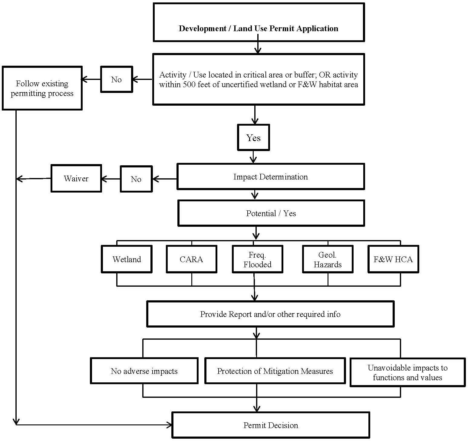
Note: Appeal process follows route of associated permit. Appeals of administrative decisions regarding provisions of this chapter use the administrative appeal process contained within Title 16A, Development Administrative Regulations.
(c) Critical Areas Present and Potential Impact Likely. If the planning director determines that the proposed project is within, adjacent to, or is likely to impact a critical area, the planning director shall:
(1) Notify the applicant that a critical area report or other applicable information must be submitted prior to further review of the project, and indicate each of the critical area types that should be addressed;
(2) Require a critical area report or other applicable information from the applicant that has been prepared by a qualified professional;
(3) Review and evaluate the critical area report and other applicable information to determine whether the development proposal conforms to the purpose and performance standards of this chapter;
(4) Assess potential impacts to the critical area and determine if they are necessary and unavoidable;
(5) Determine if any mitigation proposed by the applicant is sufficient to protect the functions and values of the critical area and public health, safety, and welfare concerns consistent with the goals, purposes, objectives, and requirements of this chapter; and
(6) A summary of this analysis and the findings shall be included in any decision on the underlying permit(s). Critical area review findings may result in: (A) no adverse impacts to critical area(s), (B) list of applicable critical area(s) protection conditions for the underlying permit(s), or (C) denial of permit based upon unavoidable impacts to critical area(s) functions and values. (Ord. 1007 § 1 (Exh. A) (part), 2020).
15.12.140 Wetland, geologically hazardous and habitat conservation areas—General report requirements.
(a) Prepared by Qualified Professional. If required by Section 15.12.130(c), the applicant shall submit a report prepared by a qualified professional as defined herein.
(b) Incorporating Best Available Science. The report shall use scientifically valid methods and studies in the analysis of data and field reconnaissance and reference the source of science used. The report shall evaluate the proposal and all probable impacts to critical areas in accordance with the provisions of this chapter.
(c) Minimum Report Contents. At a minimum, the report shall contain the following:
(1) The name and contact information of the applicant, a description of the proposal, and identification of the permit requested;
(2) A copy of the site plan for the development proposal showing:
(A) Identified critical areas, buffers, and the development proposal with dimensions;
(B) Limits of any areas to be cleared; and
(C) A description of the proposed stormwater management plan for the development and consideration of impacts to drainage alterations, consistent with the current edition of the City of Connell Design Standards;
(3) The names and professional qualifications of the persons preparing the report and documentation of any fieldwork performed on the site;
(4) Identification and characterization of all critical areas, wetlands, water bodies, and buffers adjacent to the proposed project area;
(5) A statement specifying the accuracy of the report, and all assumptions made and relied upon;
(6) An assessment of the probable cumulative impacts to critical areas resulting from development of the site and the proposed development;
(7) An analysis of site development alternatives;
(8) A description of reasonable efforts made to apply mitigation sequencing pursuant to Section 15.12.170 to avoid, minimize, and mitigate impacts to critical areas;
(9) Plans for adequate mitigation, as needed, to offset any impacts, in accordance with Sections 15.12.160 through 15.12.190, including, but not limited to:
(A) The impacts of any proposed development within or adjacent to a critical area or buffer on the critical area; and
(B) The impacts of any proposed alteration of a critical area or buffer on the development proposal, other properties and the environment;
(10) A discussion of the performance standards applicable to the critical area and proposed activity; and
(11) Financial guarantees to ensure compliance, if applicable.
(d) Unless otherwise provided, a report may be supplemented by or composed, in whole or in part, of any reports or studies required by other laws and regulations or previously prepared for and applicable to the development proposal site, as approved by the planning director. (Ord. 1007 § 1 (Exh. A) (part), 2020).
15.12.150 Wetland, geologically hazardous and habitat conservation areas—Modifications to report requirements.
(a) Limitations to Study Area. The planning director may limit the required geographic area of the report as appropriate if:
(1) The applicant, with assistance from the city, cannot obtain permission to access properties adjacent to the project area; or
(2) The proposed activity will affect only a limited part of the subject site.
(b) Modifications to Required Contents. The applicant may consult with the planning director prior to or during preparation of the report to obtain city concurrence on modifications to the required contents of the report where, in the judgment of a qualified professional, more or less information is required to adequately address the potential critical area impacts and required mitigation. (Ord. 1007 § 1 (Exh. A) (part), 2020).
15.12.160 Mitigation requirements.
(a) The applicant shall avoid all impacts that degrade the functions and values of a critical area or areas. Unless otherwise provided in this chapter, if alteration to the critical area is unavoidable, all adverse impacts to or from critical areas and buffers resulting from a development proposal or alteration shall be mitigated in accordance with the critical area report and SEPA documents.
(b) Mitigation shall be in kind and on site, when possible, and sufficient to maintain the functions and values of the critical area, and to prevent risk from a hazard posed by a critical area.
(c) Mitigation shall be in accordance with the provisions of a mitigation plan. Mitigation shall not be implemented until after city receipt of a mitigation plan and either of the following:
(1) City approval of the necessary permit(s); or
(2) City receipt of documentation of a performance bond posted by the applicant in accordance with the provisions outlined in Section 15.12.240. (Ord. 1007 § 1 (Exh. A) (part), 2020).
15.12.170 Mitigation sequencing.
Applicants shall demonstrate that all reasonable efforts have been examined with the intent to avoid and minimize impacts to critical areas. When an alteration to a critical area is proposed, such alteration shall be avoided, minimized, or compensated for in the following order of preference:
(1) Avoiding the impact altogether by not taking a certain action or parts of an action;
(2) Minimizing impacts by limiting the degree or magnitude of the action and its implementation, by using appropriate technology, or by taking affirmative steps to avoid or reduce impacts;
(3) Rectifying the impact by repairing, rehabilitating, or restoring the affected environment;
(4) Reducing or eliminating the impact or hazard over time by preservation and maintenance operations during the life of the action;
(5) Compensating for the impact by replacing, enhancing, or providing substitute resources or environments; and/or
(6) Monitoring the impact and taking appropriate corrective measures.
Mitigation for individual actions may include a combination of the above measures. (Ord. 1007 § 1 (Exh. A) (part), 2020).
15.12.180 Mitigation plan requirements.
When mitigation is required, the applicant shall submit to the city a mitigation plan as part of the critical area report or other applicable information. The mitigation plan shall include:
(1) Environmental Goals and Objectives. The mitigation plan shall include a written report identifying environmental goals and objectives of the compensation proposed and including:
(a) A description of the anticipated impacts to the critical areas and the mitigating actions proposed and the purposes of the compensation measures, including the site selection criteria; identification of compensation goals; identification of resource functions; and dates for beginning and completion of site compensation construction activities. The goals and objectives shall be related to the functions and values of the impacted critical area;
(b) A review of the best available science supporting the proposed mitigation and a description of the report author’s experience to date in restoring or creating the type of critical area proposed; and
(c) An analysis of the likelihood of success of the compensation project.
(2) Performance Standards. The mitigation plan shall address the applicable performance standards identified in this chapter.
(3) Detailed Construction Plans. The mitigation plan shall include written specifications and descriptions of the mitigation proposed, such as:
(a) The proposed construction sequence, timing, and duration;
(b) Grading and excavation details;
(c) Erosion and sediment control features;
(d) A vegetation planting plan specifying plant species, quantities, locations, size, spacing, and density; and
(e) Measures to protect and maintain plants until established.
These written specifications shall be accompanied by detailed site diagrams, scaled cross-sectional drawings, topographic maps showing slope percentage and final grade elevations, and any other drawings appropriate to show construction techniques or anticipated final outcome.
(4) Monitoring Program. The mitigation plan shall include a program for monitoring construction of the compensation project, and for assessing a completed project. A protocol shall be included outlining the schedule for site monitoring in years one, three and five after site construction, and how the monitoring data will be evaluated to determine if the performance standards are being met. However, if the project is to restore woody vegetation for forested or shrub wetlands, the monitoring should be performed in years one, two, three, five, seven, and ten. A monitoring report shall be submitted as needed to document milestones, successes, problems, and contingency actions of the compensation project. At a minimum, a monitoring report shall be submitted to document mitigation performance in year five after site construction (or five and ten years, for woody vegetation).
(5) Contingency Plan. The mitigation plan shall include identification of potential courses of action, and any corrective measures to be taken if monitoring or evaluation indicates project performance standards are not being met.
(6) Financial Guarantees. The mitigation plan shall include financial guarantees, if necessary, to ensure that the mitigation plan is fully implemented. Financial guarantees ensuring fulfillment of the compensation project, monitoring program, and any contingency measures shall be posted in accordance with Section 15.12.240. (Ord. 1007 § 1 (Exh. A) (part), 2020).
15.12.190 Innovative mitigation.
(a) The city may encourage and facilitate innovative mitigation projects. Advance mitigation or mitigation banking are examples of alternative mitigation projects allowed under the provisions of this section where one or more applicants, or an organization with demonstrated capability, may undertake a mitigation project together if it is demonstrated that all of the following circumstances exist:
(1) Creation or enhancement of a larger system of critical areas and open space is preferable to the preservation of many individual habitat areas;
(2) The group demonstrates the organizational and fiscal capability to act cooperatively;
(3) The group demonstrates that long-term management of the habitat area will be provided; and
(4) There is a clear potential for success of the proposed mitigation at the identified mitigation site.
(b) Conducting mitigation as part of a cooperative process does not reduce or eliminate the required replacement ratios. (Ord. 1007 § 1 (Exh. A) (part), 2020).
15.12.200 Unauthorized critical area alterations and enforcement.
(a) When a critical area or its buffer has been altered in violation of this chapter, all ongoing development work shall cease and the critical area shall be restored. The city shall have the authority to issue a stop work order to cease all ongoing development work, and order restoration, rehabilitation, replacement or, where determined appropriate by the planning director, mitigation measures at the owner’s or other responsible party’s expense to compensate for violation of provisions of this chapter and other applicable city code governing the underlying permit(s). For administrative procedures including but not limited to review and appeal of city actions related to unauthorized critical area alterations, see Section 15.12.040.
(b) Restoration/Mitigation Plan Required. All development work shall remain stopped until a restoration/mitigation plan is prepared and approved by city. Such a plan shall be prepared by a qualified professional and shall describe how the actions proposed meet the minimum requirements described in subsection (c) of this section and/or mitigation requirements outlined in Sections 15.12.160, 15.12.170, 15.12.180 and 15.12.190, if mitigation is determined to be appropriate by the planning director. The planning director shall, at the violator’s expense, seek expert advice in determining the adequacy of the plan. Inadequate plans shall be returned to the applicant or violator for revision and resubmittal.
(c) Minimum Performance Standards for Restoration or Mitigation.
(1) For alterations to critical aquifer recharge areas, frequently flooded areas, wetlands, and habitat conservation areas, the following minimum performance standards shall be met for the restoration or mitigation of impacts to a critical area; provided, that if the violator can demonstrate in a restoration/mitigation plan that greater functional and habitat values can be obtained, these standards may be modified by the planning director:
(A) The historic structural and functional values shall be restored, including water quality and habitat functions;
(B) The historic soil types and configuration shall be replicated;
(C) The critical area and buffers shall be replanted with native vegetation that replicates the vegetation historically found on the site in species types, sizes, and densities; and
(D) The historic functions and values should be replicated at the location of the alteration.
(2) For alterations to flood and geological hazards, the following minimum performance standards shall be met for the restoration of a critical area; provided, that, if the violator can demonstrate that greater safety can be obtained, these standards may be modified:
(A) The hazard shall be reduced to a level equal to, or less than, the pre-development hazard;
(B) Any risk of personal injury resulting from the alteration shall be eliminated or minimized; and
(C) The hazard area and buffers shall be replanted with native vegetation sufficient to minimize the hazard.
(d) Penalties. Any person, party, firm, corporation, or other legal entity convicted of violating any of the provisions of this chapter shall be guilty of a misdemeanor. Each day or portion of a day during which a violation of this chapter is committed or continued shall constitute a separate offense. Any development carried out contrary to the provisions of this chapter shall constitute a public nuisance and may be enjoined as provided by the statutes of the state of Washington. The city may levy civil penalties against any person, party, firm, corporation, or other legal entity for violation of any of the provisions of this chapter. The civil penalty shall be a fine not to exceed one thousand dollars or imprisonment for not more than ninety days, or both such fine and imprisonment per violation. Daily fines shall not be levied until after a violator has received a notice of violation and shall not be levied while the violator is making a good faith and diligent effort to correct the violation in cooperation with city enforcement personnel nor while a notice of violation is under appeal through the applicable appeal process. (Ord. 1007 § 1 (Exh. A) (part), 2020).
15.12.210 Critical area markers and signs.
The critical area or buffer shall be identified with temporary signs prior to any site alteration. Such temporary signs may be replaced with permanent signs, as determined appropriate by the planning director. (Ord. 1007 § 1 (Exh. A) (part), 2020).
15.12.220 Native growth habitat areas.
(a) Unless otherwise required in this chapter, native growth habitat areas shall be used in development proposals for subdivisions, short subdivisions, planned unit developments, and binding site plans to delineate and protect those contiguous critical areas and buffers listed below:
(1) All landslide hazard areas and buffers;
(2) All wetlands and buffers;
(3) All habitat conservation areas; and
(4) All other lands to be protected from alterations as conditioned by project approval.
See Exhibit 1 or the latest revision of this map for designated wetlands, erosion hazard areas and habitat conservation areas. (Ord. 1007 § 1 (Exh. A) (part), 2020).
15.12.230 Building setbacks.
Unless otherwise provided, buildings and other structures shall be set back a distance of fifteen feet from the edges of all critical area buffers or from the edges of all critical areas, if no buffers are required. The following may be allowed in the building setback area:
(1) Landscaping;
(2) Uncovered decks;
(3) Building overhangs if such overhangs do not extend more than eighteen inches into the setback area; and
(4) Impervious surfaces, such as driveways and patios; provided, that such improvements may be subject to requirements provided in the most current edition of the City of Connell Design Standards. (Ord. 1007 § 1 (Exh. A) (part), 2020).
15.12.240 Bonds to ensure mitigation, maintenance, and monitoring.
(a) Mitigation required pursuant to a development proposal should be completed prior to city final permit approval, such as final plat approval or final building permit inspection. When mitigation required pursuant to a development proposal is not completed prior to the city final permit approval, such as final plat approval or final building inspection, the city shall require the applicant to post a performance bond or other security in a form and amount deemed acceptable by the city. If the development proposal is subject to mitigation, the applicant shall post a mitigation bond or other security in a form and amount deemed acceptable by the city to ensure mitigation is fully functional.
(b) The performance and/or mitigation bond shall be in the amount of one hundred twenty-five percent of the estimated cost of the uncompleted actions or the estimated cost of restoring the functions and values of the critical area that are at risk, whichever is greater, and the cost of maintenance and monitoring for a ten-year period.
(c) The bond shall be in the form of an assignment of surety bond, performance bond, assignment of savings account, or an irrevocable letter of credit guaranteed by an acceptable financial institution with terms and conditions acceptable to the city attorney or other method acceptable to the city planning director.
(d) The performance bonds shall remain in effect until the city determines, in writing, that the standards bonded for have been met. Bonds shall be held by the city for a minimum of ten years to ensure that the required mitigation has been fully implemented and demonstrated to function, and may be held for longer periods when necessary.
(e) Depletion, failure, or collection of bond funds shall not discharge the obligation of an applicant or violator to complete required mitigation, maintenance, monitoring, or restoration.
(f) Public development proposals shall be relieved from having to comply with the bonding requirements of this section if public funds have previously been committed for mitigation, maintenance, monitoring, or restoration.
(g) Any failure to satisfy critical area requirements established by law or condition including, but not limited to, the failure to provide a monitoring report within thirty days after it is due or comply with other provisions of a mitigation plan shall constitute a default, and the city may demand payment of any financial guarantees or require other action authorized by the city code or any other law.
(h) Any funds recovered pursuant to this section shall be used to complete the required mitigation. (Ord. 1007 § 1 (Exh. A) (part), 2020).
15.12.250 Critical area inspections.
Reasonable access to the site shall be provided to the city, state, and federal agency review staff for the purposes of inspections during any proposal review, restoration, emergency action, or monitoring period. Additionally, the city or its agent shall have reasonable access to the site for completing necessary remediation work in the event of noncompliance. (Ord. 1007 § 1 (Exh. A) (part), 2020).
15.12.260 Enforcement.
This chapter shall be enforced in the same manner as provided in Title 17 for the enforcement of the zoning code. (Ord. 1007 § 1 (Exh. A) (part), 2020).
Article II. Wetlands
15.12.310 Designation, rating, delineating, and mapping wetlands.
(a) Designating Wetlands. Wetlands are those areas, designated in accordance with the approved federal wetland delineation manual and applicable regional supplements (WAC 173-22-035), that are inundated or saturated by surface or ground water at a frequency and duration sufficient to support, and that under normal circumstances do support, a prevalence of vegetation adapted for life in saturated soil conditions. All areas within the city of Connell meeting the wetland designation criteria in the approved manual, regardless of any formal identification, are hereby designated critical areas and are subject to the provisions of this chapter. Artificial wetlands are not regulated by Washington State, but they may be subject to other regulatory authority, such as the U.S. Army Corps of Engineers. So long as a wetland is not “artificial,” a wetland delineation shall be required and the applicant must and shall submit a wetland management and mitigation plan, as provided for in this chapter.
(b) Wetland Ratings. Wetlands shall be rated according to the Department of Ecology wetland rating system found in the Washington State Wetland Rating for Eastern Washington: 2014 Update (Ecology Publication No. 14-06-030) or as revised by Ecology. This document contains definitions and methods for determining if the general criteria below are met.
(1) Wetland Rating Categories.
(A) Category I. Category I wetlands include those that receive a score of twenty-two through twenty-seven based on functions, or those that are rated Category I based on special characteristics as defined in the rating manual.
(B) Category II. Category II wetlands are those not defined as Category I wetlands that receive a score of nineteen through twenty-one based on functions, or those that are rated Category II based on special characteristics as defined in the rating manual.
(C) Category III. Category III wetlands are those that do not satisfy Category I, II or IV criteria, and receive a score of sixteen through eighteen based on functions.
(D) Category IV. Category IV wetlands are those that score less than sixteen points based on functions.
(2) Date of Wetland Rating. Wetland rating categories shall be applied as the wetland exists on the date of adoption of the rating system by the local government, as the wetland naturally changes thereafter, or as the wetland changes in accordance with permitted activities. Wetland rating categories shall not change due to illegal modifications.
(c) Wetland Delineation. Wetlands shall be delineated using the federal wetland delineation manual and applicable regional supplements in accordance with WAC 173-22-035. Wetland delineations are valid for five years; after such date the city shall determine whether a revision or additional assessment is necessary.
(d) Mapping. The approximate location and extent of known wetlands are shown on the adopted critical areas map (Exhibit 1 or the latest revision of this map) as derived from the National Wetlands Inventory. This map is to be used as a guide for the city, project applicants and/or property owners, and may be continuously updated as new critical areas are identified. It is a reference and does not provide a final critical area designation.
The exact location of a wetland’s boundary shall be determined through the performance of a field investigation by a qualified professional. Wetlands shall be delineated using the federal wetland delineation manual and applicable regional supplements in accordance with WAC 173-22-035. Wetland boundaries shall be clearly demarcated with nondegradable survey flagging labeled “WETLAND BOUNDARY” or “WETLAND DELINEATION.” Flagging shall be attached to existing vegetation or wooden stakes at a minimum every fifty linear feet. Individual flags should be labeled with a wetland identifier and consecutive numbers (e.g., A-1 through A-8). (Ord. 1007 § 1 (Exh. A) (part), 2020).
15.12.320 Regulated activities.
For any regulated activity, a critical areas report may be required to support the requested activity. The following activities are regulated if they occur in a regulated wetland or its buffer:
(1) The removal, excavation, grading, or dredging of soil, sand, gravel, minerals, organic matter, or material of any kind.
(2) The dumping of, discharging of, or filling with any material.
(3) The draining, flooding, or disturbing of the water level or water table.
(4) Pile driving.
(5) The placing of obstructions.
(6) The construction, reconstruction, demolition, or expansion of any structure.
(7) The destruction or alteration of wetland vegetation through clearing, harvesting, shading, intentional burning, or planting of vegetation that would alter the character of a regulated wetland.
(8) Class IV general forest practices under the authority of the “1992 Washington State Forest Practices Act Rules and Regulations,” WAC 222-12-030, or as thereafter amended.
(9) Activities that result in a significant change of water temperature, a significant change of physical or chemical characteristics of the sources of water to the wetland, a significant change in the quantity, timing or duration of the water entering the wetland, or the introduction of pollutants. (Ord. 1007 § 1 (Exh. A) (part), 2020).
15.12.330 Activities allowed in wetlands.
The activities listed below are allowed in wetlands in addition to those activities listed in, and consistent with, the provisions established in Section 15.12.110, and do not require submission of a report, except where such activities result in the loss to the functions and values of a wetland or wetland buffer. These activities include:
(1) Conservation or preservation of soil, water, vegetation, fish, shellfish, and other wildlife that does not entail changing the structure or functions of the existing wetland.
(2) The harvesting of wild crops in a manner that is not injurious to natural reproduction of such crops and provided the harvesting does not require tilling of soil, planting of crops, or alteration of the wetland by changing existing topography, water conditions or water sources.
(3) Existing and ongoing agricultural activities; provided, that they implement applicable best management practices (BMPs) contained in the latest editions of the USDA Natural Resources Conservation Service (NRCS) Field Office Technical Guide (FOTG); or develop a farm conservation plan in coordination with the Franklin Conservation District.
(4) Drilling for utilities/utility corridors under a wetland, with entrance/exit portals located completely outside of the wetland buffer; provided, that the drilling does not interrupt the ground water connection to the wetland or percolation of surface water down through the soil column. Specific studies by a hydrologist are necessary to determine whether the ground water connection to the wetland or percolation of surface water down through the soil column will be disturbed.
(5) Enhancement of a wetland through the removal of nonnative invasive plant species. Removal of invasive plant species shall be restricted to hand removal unless permits from the appropriate regulatory agencies have been obtained for approved biological or chemical treatments. All removed plant material shall be taken away from the site and appropriately disposed of. Plants that appear on the Washington State Noxious Weed Control Board list of noxious weeds must be handled and disposed of according to a noxious weed control plan appropriate to that species. Re-vegetation with appropriate native species at natural densities is allowed in conjunction with removal of invasive plant species.
(6) Educational and scientific research activities.
(7) Normal and routine maintenance and repair of any existing public or private facilities within an existing right-of-way; provided, that the maintenance or repair does not expand the footprint of the facility or right-of-way.
(8) Activities conducted by public agencies to control mosquitoes in compliance with state and federal laws shall be exempt from city wetland regulations. (Ord. 1007 § 1 (Exh. A) (part), 2020).
15.12.335 Activities allowed in wetland buffers.
The following activities are permitted within the wetland buffer; provided, that any impacts or damage to the wetland buffer is fully mitigated through the requirements of this chapter. In planning and constructing these activities, reasonable measures shall be taken to protect any trees.
(1) Wells and necessary appurtenances associated with single-family dwellings, including a pump and appropriately sized pump house, may be allowed in a wetland buffer if city water is not available within two hundred feet of the property and there are no other alternative locations available for a well on the property. In such case, the well shall be constructed such that it does not withdraw water from any shallow upper aquifer, or allow water from the wetland to infiltrate into the well hole directly. Any disturbance to the wetland buffer area as a result of the well installation shall be restored in a timely manner.
(2) Trails no more than five feet in width, observation areas, and viewing platforms; provided, that in the case of Category I wetlands, the minimum distance from the wetland edge is not less than fifty percent of the Category I buffer width established in Section 15.12.350(d). A decrease in the required buffer width through buffer width averaging or other means does not indicate a corresponding decreased distance from a Category I wetland edge for trails, observation areas, and viewing platforms. Trails shall generally be located towards the perimeter of the buffer (in the outer twenty-five percent), and directly perpendicular to the wetland in the case of trails to observation areas and viewing platforms.
(3) The placement of underground utility lines, residential on-site septic drain fields meeting the requirements of the Benton-Franklin Health District when city sewer is not available, and bioswales and detention/retention facilities for on-site stormwater treated by biofiltration or other processes prior to discharge when consistent with the Stormwater Management Manual for Eastern Washington; provided the minimum distance from the wetland edge is not less than seventy-five percent of the buffer widths established in Section 15.12.350(d). Regional stormwater facilities shall not be located within the wetland buffers of Type I and II wetlands, and may be located within the wetland buffers of Type III and IV wetlands only when the wetland is sufficiently protected from water quality degradation and excessive water level fluctuations, and the facility is constructed in a manner that results in an enhancement to the buffer area.
(4) Placement of access roads and utilities across Category II, III and IV wetland buffers, if the department determines that there is no reasonable alternative location for providing access and/or utilities to an existing lot and mitigation is provided as designated in this chapter.
(5) The installation of stormwater management facilities, limited to stormwater dispersion outfalls and bioswales, within the outer twenty-five percent of a critical area buffer; provided, that:
(a) No other location is feasible; and
(b) The location of such facilities will not degrade the functions or values of the critical area; and
(c) The buffer is not for a Category I wetland.
(6) The creation of lots from parcels containing wetlands and wetland buffers, subject to the following:
(a) Land that is located wholly within a wetland or its buffer may not be subdivided;
(b) Land that is located partially within a wetland or its buffer is not precluded from being divided due to the presence of the wetland or buffer, provided:
(i) The wetland and its buffer are contained within a separate open space tract, as depicted on the document dividing the property (short plat, long plat, etc.); and
(ii) The proposed lots are accessible through a route that is outside of the wetland and its buffer.
To compensate for setting aside the wetland and buffer area in a separate tract, those lots immediately adjacent to the wetland tract and served with city sewer and city water need only be seventy-five percent of the minimum lot size and lot depth normally required, and permitted lot coverage shall be calculated as if the lot were the normal minimum lot size. (Ord. 1007 § 1 (Exh. A) (part), 2020).
15.12.340 Wetlands report—Additional requirements.
(a) Prepared by a Qualified Professional. A qualified professional shall prepare a report for wetlands. The city shall determine whether a person is a qualified professional based on criteria established in WAC 395-195-905(4).
(b) Area Addressed in Report. The following areas shall be addressed in a report for wetlands:
(1) The project area of the proposed activity;
(2) All wetlands and recommended buffers within two hundred fifty feet of the project area, as critical area reports should consider wetlands and other critical areas within two hundred fifty feet due to the maximum potential buffer recommended for wetlands; and
(3) All shoreline areas, water features, floodplains, and other critical areas, and related buffers within two hundred feet of the project area.
(c) Wetland Analysis. In addition to the minimum required contents of reports in Sections 15.12.140 and 15.12.150, a report for wetlands shall contain an analysis of the wetlands including the following site- and proposal-related information at a minimum:
(1) A written assessment and accompanying maps of the wetlands and buffers within two hundred feet of the project area, including the following information at a minimum:
(A) Wetland delineation and required buffers;
(B) Existing wetland acreage;
(C) Wetland category; vegetative, faunal, and hydrologic characteristics; and
(D) Soil and substrate conditions.
(2) A discussion of measures, including avoidance, minimization and mitigation, proposed to preserve existing wetlands and restore any wetlands that were degraded prior to the current proposed land use activity.
(3) Proposed mitigation, if needed, including a written assessment and accompanying maps of the mitigation area, including the following information at a minimum:
(A) Existing wetland acreage and proposed impact area;
(B) Vegetative, faunal, and hydrologic conditions;
(C) Relationship within watershed and to existing water bodies;
(D) Soil and substrate conditions, topographic elevations;
(E) Existing and proposed adjacent site conditions;
(F) Required wetland buffers; and
(G) Property ownership.
(4) A discussion of ongoing management practices that will protect wetlands after the project site has been developed, including proposed monitoring and maintenance programs.
(d) Additional Information May Be Required. When appropriate, the city may also require the report to include an evaluation by the Department of Ecology or an independent qualified expert regarding the applicant’s analysis and the effectiveness of any proposed mitigating measures or programs, and to include any recommendations as appropriate. (Ord. 1007 § 1 (Exh. A) (part), 2020).
15.12.350 Performance standards—General requirements.
(a) Activities may only be permitted in a wetland or wetland buffer if the applicant can show that the proposed activity will not degrade the functions and values of the wetland and other critical areas.
(b) Activities and uses shall be prohibited from wetlands and wetland buffers, except as provided for in this chapter.
(c) Impact of Land Use. Impact to wetlands may vary based on land use. Buffer widths in subsection (d) of this section shall be based on the level of impact categorized in the following table:
|
Level of Impact from Proposed Change in Land Use |
Types of Land Uses |
|
|---|---|---|
|
High |
• |
Commercial, including retail sales |
|
|
• |
Industrial |
|
|
• |
Institutional |
|
|
• |
Residential (more than 1 unit per acre) |
|
|
• |
High-intensity recreation (ball fields, golf driving ranges, golf courses, gun ranges, clubhouses, recreational buildings, etc., and associated parking lots) |
|
|
• |
High-intensity farming practices (greenhouses, nurseries, animal pens and barns, etc.) |
|
Moderate |
• |
Residential (less than or equal to 1 unit per acre) |
|
• |
Moderate-intensity open space (parks and paved trails) |
|
|
|
• |
Conversion to moderate-intensity agriculture (orchards, hay fields, spray fields, etc.) |
|
|
• |
Utility corridor or utility right-of-way containing an access/maintenance road wider than 10 feet in width |
|
Low |
• |
Low-intensity open space (hiking, bird watching, neighborhood parks without parking, preservation of natural resources, etc.) |
|
|
• |
Unpaved trails |
|
|
• |
Utility corridor without an access/maintenance road and little or no vegetation management |
(d) Wetland Buffers.
(1) Standard Buffer Widths. The standard buffer widths presume the existence of a relatively intact native vegetation community in the buffer zone adequate to protect the wetland functions and values at the time of the proposed activity. If the vegetation is inadequate then the buffer width shall be increased or the buffer should be planted to maintain the standard width. Required standard wetland buffers, based on wetland category and land use intensity, are as follows, based on Wetlands and CAO Updates: Guidance for Small Cities, Eastern Washington Version,” Department of Ecology, 2010, Publication No. 10-06-001.
|
Wetland Characteristics |
Buffer Width by Impact of Land Use |
|---|---|
|
Category I |
Low—125 feet |
|
|
Moderate—190 feet |
|
|
High—250 feet |
|
Category II |
Low—100 feet |
|
|
Moderate—150 feet |
|
|
High—200 feet |
|
Category III |
Low—75 feet |
|
|
Moderate—110 feet |
|
|
High—150 feet |
|
Category IV |
Low—25 feet |
|
|
Moderate—40 feet |
|
|
High—50 feet |
(2) Measurement of Wetland Buffers. All buffers shall be measured from the wetland boundary as surveyed in the field. The width of the wetland buffer shall be determined according to the wetland category and the proposed land use. The buffer for a wetland created, restored, or enhanced as compensation for wetland alterations shall be the same as the buffer required for the category of the created, restored, or enhanced wetland.
(3) Increased Wetland Buffer Widths. The city shall require increased buffer widths in accordance with the recommendations of a qualified professional biologist and the best available science on a case-by-case basis when a larger buffer is necessary to protect wetland functions and values based on site-specific characteristics. This determination shall be based on one or more of the following criteria:
(A) A larger buffer is needed to protect other critical areas;
(B) The buffer or adjacent uplands has a slope greater than fifteen percent or is susceptible to erosion and standard erosion-control measures will not prevent adverse impacts to the wetland; or
(C) The buffer area has minimal vegetative cover. In lieu of increasing the buffer width where existing buffer vegetation is inadequate to protect the wetland functions and values, implementation of a buffer planting plan may substitute. Where a buffer planting plan is proposed, it shall include provisions for monitoring and maintenance to ensure success.
(D) At no time shall wetland buffers be increased to a width two times that of the standard required buffer.
(4) Reduction of Wetland Buffer Widths.
(A) The city may allow the standard wetland buffer width to be reduced in accordance with the report and the best available science on a case-by-case basis when it is determined that a smaller area is adequate to protect the wetland functions and values based on site-specific characteristics.
(B) This determination shall be supported by documentation showing that a reduced buffer is adequate based on all of the following criteria:
(i) Requiring the standard buffer poses an extraordinary hardship on the landowner, as determined by the planning director;
(ii) The existing buffer area is well vegetated with native species and has less than ten percent slopes; and
(iii) No direct or indirect, short-term or long-term adverse impacts to wetlands will result from the proposed activity.
(C) The city may require long-term monitoring of the buffer and wetland. Subsequent corrective actions may be required if adverse impacts to wetlands are discovered during the monitoring period.
(D) In no case shall the standard buffer width be reduced by more than twenty-five percent, or the buffer width be less than fifty feet, whichever is greater, unless the applicant demonstrates an acceptable reasonable use as described in Section 15.12.120.
(5) Wetland Buffer Width Averaging. The city may allow modification of the standard wetland buffer width in accordance with the report and the best available science on a case-by-case basis by averaging buffer widths. Averaging of buffer widths may only be allowed where a qualified wetlands professional demonstrates that:
(A) It will not reduce wetland functions or values;
(B) The wetland contains variations in sensitivity due to existing physical characteristics or the character of the buffer varies in slope, soils, or vegetation, and the wetland would benefit from a wider buffer in places and would not be adversely impacted by a narrower buffer in other places;
(C) The total area contained in the buffer area after averaging is no less than that which would be contained within the standard buffer; and
(D) The buffer width is not reduced to less than twenty-five percent of the standard width or fifty feet, whichever is greater, unless the applicant demonstrates an acceptable reasonable use as described in Section 15.12.120.
(6) Buffers for Mitigation Shall Be Consistent. All mitigation sites shall have buffers consistent with the buffer requirements of this chapter.
(7) Buffer Conditions Shall Be Maintained. Except as otherwise specified or allowed in accordance with this chapter, wetland buffers shall be retained in their natural condition.
(8) Functionally Isolated Buffer Areas. Areas which are functionally separated from a wetland and do not provide protection to the wetland from potential adverse impacts due to preexisting roads, structures, or vertical separation, shall be excluded from buffers otherwise required by this chapter.
(e) Signs and Fencing of Wetlands.
(1) Temporary Markers. The outer perimeter of the wetland or buffer and the limits of those areas to be disturbed pursuant to an approved permit or authorization shall be marked in the field in such a way as to ensure that no unauthorized intrusion will occur, and inspected by the city prior to the commencement of permitted activities. This temporary marking shall be maintained throughout construction, and shall not be removed until permanent signs, if required, are in place.
(2) Permanent Signs. As a condition of any permit or authorization issued pursuant to this chapter, the city may require the applicant to install permanent signs along the boundary of a wetland and/or buffer.
If required, permanent signs shall be made of a metal face and attached to a metal post, or another material of equal durability. Signs must be posted at an interval of one per lot or every fifty feet, whichever is less, and must be maintained by the property owner in perpetuity. The sign shall be worded as follows or with alternative language approved by the director:
“Protected Wetland Area”
“Do Not Disturb”
“Contact the City of Connell
Regarding Uses and Restrictions”
(3) Fencing.
(A) The city may condition any permit or authorization issued pursuant to this chapter to require the applicant to install a permanent fence at the edge of the wetland buffer, when fencing will prevent future impacts to the wetland.
(B) The applicant shall be required to install a permanent fence around the wetland or buffer when domestic grazing animals are present or may be introduced on site.
(C) Fencing installed as part of a proposed activity or as required in this subsection shall be designed so as to not interfere with species migration, including fish runs, and shall be constructed in a manner that minimizes impacts to the wetland and associated habitat.
(D) At no time shall treated wood posts (e.g., creosote or CCA) be allowed in wetland areas or in adjacent uplands to prevent chemicals from migrating into the wetland. (Ord. 1007 § 1 (Exh. A) (part), 2020).
15.12.360 Performance standards—Specific activities and uses.
The following activities may be permitted within a wetland buffer in accordance with the review procedures of this chapter, provided they are not prohibited by any other applicable law and they are conducted in a manner so as to minimize impacts to the buffer and adjacent wetland:
(1) Conservation and Restoration Activities. Conservation or restoration activities aimed at protecting the soil, water, vegetation, or wildlife.
(2) Passive Recreation. Passive recreation facilities designed and in accordance with the report, including:
(a) Walkways and trails; provided, that those pathways that are generally parallel to the perimeter of the wetland shall be located in the outer twenty-five percent of the buffer area;
(b) Wildlife viewing structures; and
(c) Fishing access areas.
(3) Stormwater Management Facilities. Stormwater management facilities are not allowed in buffers of Category I or II wetlands. Stormwater management facilities, limited to stormwater dispersion outfalls and bioswales, may be allowed within the outer twenty-five percent of the buffer of Category III or IV wetlands only; provided, that:
(a) No other location is feasible; and
(b) The location of such facilities will not degrade the functions or values of the wetland.
(4) Subdivisions. The subdivision and short subdivision of land in wetlands and associated buffers are subject to the following:
(a) Land that is located wholly within a wetland or its buffer may not be subdivided;
(b) Land that is located partially within a wetland or its buffer may be divided; provided, that an accessible and contiguous portion of each new lot is:
(i) Located outside of the wetland and its buffer; and
(ii) Meets the minimum lot size requirements of the city zoning code (Title 17);
(c) Access roads and utilities serving the proposed subdivision may be permitted within the wetland and associated buffers only if the city determines that no other feasible alternative exists in and when consistent with this chapter. (Ord. 1007 § 1 (Exh. A) (part), 2020).
15.12.370 Performance standards—Mitigation requirements.
(a) Mitigation Shall Achieve Equivalent or Greater Biological Functions. Mitigation for alterations to wetlands shall achieve equivalent or greater biologic functions and shall be consistent with the Wetland Mitigation in Washington State—Part 2: Developing Mitigation Plans—Version 1 (Ecology Publication No. 06-06-011b, or as revised), and Selecting Wetland Mitigation Sites Using a Watershed Approach (Eastern Washington) (Publication No. 10-06-07, November 2010).
(b) Mitigation Shall Result in No Net Loss. Wetland mitigation actions shall not result in a net loss of wetland area except when the following criteria are met:
(1) The lost wetland area provides minimal functions and the mitigation action(s) results in a net gain in wetland functions as determined by a site-specific function assessment using Department of Ecology Methods for Assessing Wetland Functions Vol. 2—Depressional Wetlands in the Columbia Basin of Eastern Washington, Parts 1 and 2 (Publication Nos. 00-06-047 and No. 00-06-048, December 2000), or as revised; or
(2) The lost wetland area provides minimal functions as determined by a site-specific function assessment and other protected or enhanced habitats provide greater benefits to the functioning of the watershed, such as riparian habitat protection and enhancement.
(c) Mitigation for Lost Functions and Values. Mitigation actions, such as compensatory mitigation, shall address functions affected by the alteration to achieve functional equivalency or improvement, and shall provide similar wetland functions as those lost except when:
(1) The lost wetland provides minimal functions as determined by a site-specific function assessment and the proposed mitigation action(s) will provide equal or greater functions or will provide functions shown to be limiting within a watershed through a formal watershed assessment protocol; or
(2) Out-of-kind replacement will best meet formally identified regional goals, such as replacement of historically diminished wetland types.
(d) Preference of Mitigation Actions. Mitigation actions that require compensation by replacing, enhancing, or substitution, shall occur in the following order of preference:
(1) Restoring wetlands on upland sites that were formerly wetlands.
(2) Creating wetlands on disturbed upland sites such as those with vegetative cover consisting primarily of exotic introduced species.
(3) Enhancing significantly degraded wetlands.
(4) Preserving high-quality wetlands that are under imminent threat.
(e) Type and Location of Mitigation. Mitigation actions shall be conducted within the same sub-drainage basin and on the same site as the alteration except when the following apply:
(1) There are no reasonable on-site opportunities or on-site opportunities do not have a high likelihood of success due to development pressures, adjacent land uses, or on-site buffers or connectivity are inadequate;
(2) Off-site mitigation has a greater likelihood of providing equal or improved wetland functions than the impacted wetland; and
(3) Off-site locations shall be in the same sub-drainage basin and the same water resource inventory area (WRIA) unless:
(A) The impact is located near the boundary of a WRIA;
(B) Established regional or watershed goals for water quality, flood or conveyance, habitat or other wetland functions have been established and strongly justify location of mitigation at another site; or
(C) Credits from a state certified wetland mitigation bank are used as mitigation and the use of credits is consistent with the terms of the bank’s certification.
(f) Mitigation Timing. Where feasible, mitigation projects shall be completed prior to activities that will disturb wetlands. In all other cases, mitigation shall be completed immediately following disturbance and prior to use or occupancy of the activity or development. Construction of mitigation projects shall be timed to reduce impacts to existing wildlife and flora.
The city may authorize a one-time temporary delay, up to one hundred twenty days, in completing minor construction and landscaping when environmental conditions could produce a high probability of failure or significant construction difficulties. The delay shall not create or perpetuate hazardous conditions or environmental damage or degradation, and the delay shall not be injurious to the health, safety and general welfare of the public. The request for the temporary delay must include a written justification that documents the environmental constraints that preclude implementation of the mitigation plan. The justification must be verified and approved by the city, and include a financial guarantee in the form of a cash bond or similar mechanism.
(g) Mitigation Ratios.
(1) Acreage Replacement Ratios. The following ratios shall apply to creation, replacement, or enhancement that is in kind, on-site, the same category, timed prior to or concurrent with alteration, and has a high probability of success. These ratios do not apply to remedial actions resulting from unauthorized alterations; greater ratios shall apply in those cases. These ratios do not apply to the use of credits from a state certified wetland mitigation bank. When credits from a certified bank are used, replacement ratios should be consistent with the requirements of the bank’s certification. The written ratios are based on “Wetland Mitigation Replacement Ratios: Defining Equivalency,” Department of Ecology, 1992, Publication No. 92-08, and are written such that the first number specifies the acreage of replacement wetlands and the second specifies the acreage of wetlands altered.
|
Wetland Type |
Creation or Replacement Ratio |
Enhancement Ratio |
|---|---|---|
|
Category I |
6 to 1 |
24 to 1 |
|
Category II |
3 to 1 |
12 to 1 |
|
Category III |
2 to 1 |
8 to 1 |
|
Category IV |
1.5 to 1 |
6 to 1 |
(2) Increased Replacement Ratio. The city may increase the ratios under the following circumstances:
(A) Uncertainty exists as to the probable success of the proposed restoration or creation; or
(B) A significant period of time will elapse between impact and replication of wetland functions; or
(C) Proposed mitigation will result in a lower category wetland or reduced functions relative to the wetland being impacted; or
(D) The impact was an unauthorized impact.
(3) Decreased Replacement Ratio. The city may decrease these ratios under the following circumstances:
(A) Documentation by a qualified wetlands specialist demonstrates that the proposed mitigation actions have a very high likelihood of success;
(B) Documentation by a qualified wetlands specialist demonstrates that the proposed mitigation actions will provide functions and values that are significantly greater than the wetland being impacted; or
(C) The proposed mitigation actions are conducted in advance of the impact and have been shown to be successful.
(4) Minimum Replacement Ratio. In all cases, a minimum acreage replacement ratio of one-to-one shall be required.
(h) Wetland Mitigation Banks.
(1) Credits from a wetland mitigation bank may be approved for use as compensation for unavoidable impacts to wetlands when:
(A) The bank is certified under Chapter 173-700 WAC;
(B) The city determines that the wetland mitigation bank provides appropriate compensation for the authorized impacts; and
(C) The proposed use of credits is consistent with the terms and conditions of the bank’s certification.
(2) Replacement ratios for projects using bank credits shall be consistent with replacement ratios specified in the bank’s certification.
(3) Credits from a certified wetland mitigation bank may be used to compensate for impacts located within the service area specified in the bank’s certification. In some cases, bank service areas may include portions of more than one water resource inventory area (WRIA) for specific wetland functions.
(i) Wetlands Enhancement as Mitigation.
(1) Impacts to wetlands may be mitigated by enhancement of existing significantly degraded wetlands. Applicants proposing to enhance wetlands must produce a report that identifies how enhancement will increase the functions of the degraded wetland and how this increase will adequately mitigate for the loss of wetland area and function at the impact site. An enhancement proposal must also show whether existing wetland functions will be reduced by the enhancement actions.
(2) At a minimum, enhancement acreage shall be double the acreage required for creation or restoration under subsection (g) of this section. The ratios shall be greater than double the required acreage where the enhancement proposal would result in minimal gain in the performance of wetland functions and/or result in the reduction of other wetland functions currently being provided in the wetland.
(j) Wetland Preservation as Mitigation. Impacts to wetlands may be mitigated by preservation of wetland areas when used in combination with other forms of mitigation such as creation, restoration, or enhancement at the preservation site or at a separate location. Preservation may also be used by itself, but more restrictions, as outlined below, will apply.
(1) Preservation in Combination with Other Forms of Compensation. Preservation as mitigation is acceptable when done in combination with restoration, creation, or enhancement providing that a minimum of one-to-one acreage replacement is provided by restoration or creation and the criteria below are met.
(A) The impact area is small, and/or impacts are to a Category III or IV wetland;
(B) Preservation of a high-quality system occurs in the same water resource inventory area (WRIA) or watershed basin as the wetland impact; and
(C) Preservation sites include buffer areas adequate to protect the habitat and its functions from encroachment and degradation.
(2) Preservation as the Sole Means of Mitigation for Wetland Impacts. Preservation of at-risk, high-quality habitat may be considered as the sole means of mitigation for wetland impacts when all of the following criteria are met:
(A) Preservation is used as a form of mitigation only after the standard sequencing of mitigation (avoid, minimize, and then compensate) has been applied;
(B) Creation, restoration, and enhancement opportunities have also been considered, and preservation is the best mitigation option;
(C) The impact area is small and/or impacts are to a Category III or IV wetland;
(D) Preservation of a high-quality system occurs in the same water resource inventory area (WRIA) or a watershed where the wetland impact occurs;
(E) Preservation sites include buffer areas adequate to protect the habitat and its functions from encroachment and degradation;
(F) The preservation site is determined to be under imminent threat, specifically, sites with the potential to experience a high rate of undesirable ecological change due to on- or off-site activities (“potential” includes permitted, planned, or perceived actions); and
(G) The area proposed for preservation is of high quality and critical for the health of the watershed or basin. Some of the following features may be indicative of high-quality sites:
(i) Category I or II wetland rating;
(ii) Rare wetland type (for example, bogs, estuaries);
(iii) Habitat for threatened or endangered species;
(iv) Wetland type that is rare in the area;
(v) Provides biological and/or hydrological connectivity;
(vi) High regional or watershed importance (for example, listed as priority site in watershed plan); and
(vii) Large size with high species diversity (plants and/or animals) and/or high abundance.
(3) Mitigation Ratios for Preservation as the Sole Means of Mitigation. Mitigation ratios for preservation as the sole means of mitigation shall range from seven-to-one to twenty-to-one, as determined by the city, depending on the quality of wetlands being mitigated and the quality of the wetlands being preserved.
(k) Mitigation Maintenance and Monitoring. Mitigation areas will be maintained and monitored for a minimum of five years after the mitigation has been completed. Annual maintenance and monitoring reports will be submitted to the city and shall include:
(1) Descriptive data for vegetation, soils, and hydrology.
(2) Itemized list of dead, dying, and replaced vegetation.
(3) Quantitative assessment of invasive species.
(4) Descriptive photographs.
(5) Statement of overall success of mitigation.
(6) Schedule of activities for the next year of maintenance and monitoring.
The city may extend maintenance and monitoring for mitigation projects that fail to achieve performance standards outlined in the mitigation plan. An example of a performance failure is less than eighty percent survival of native vegetation or more than ten percent of the mitigation area covered with nonnative invasive species. (Ord. 1007 § 1 (Exh. A) (part), 2020).
Article III. Critical Aquifer Recharge Areas
15.12.410 Critical aquifer recharge areas designation.
Critical aquifer recharge areas (CARA) are those areas with a critical recharging effect on aquifers used for potable water as defined by WAC 365-190-030(3). CARA have prevailing geologic conditions associated with infiltration rates that create a high potential for contamination of ground water resources or contribute significantly to the replenishment of ground water. The following areas have been identified based on local conditions:
(1) Wellhead Protection Areas. Wellhead protection areas shall be defined by the boundaries of the ten-year time of ground water travel, or boundaries established using alternate criteria approved by the Department of Health in those settings where ground water time of travel is not a reasonable delineation criterion, in accordance with WAC 246-290-135.
(2) Special Protection Areas. Special protection areas are those areas defined by WAC 173-200-090 serving to identify ground waters that require increased protection due to unique characteristics. There are no known special protection areas in the city of Connell. If they are identified in the future, they are regulated by this chapter. (Ord. 1007 § 1 (Exh. A) (part), 2020).
15.12.420 Mapping of critical aquifer recharge areas.
(a) The approximate location and extent of critical aquifer recharge areas are shown on the Source Water Assessment Program (SWAP) map, maintained by the Department of Health, Office of Drinking Water, available online at https://fortress.wa.gov/doh/swap.
(b) This map is to be used as a guide for the city, project applicants and/or property owners, and may be continuously updated as new information becomes available. (Ord. 1007 § 1 (Exh. A) (part), 2020).
15.12.430 Regulation.
The following are in place to protect critical aquifer recharge areas and regulate activities that might potentially impact these areas:
(1) City of Connell sewer regulations (Title 13), including provisions for wellhead protection areas.
(2) City of Connell building code (Title 14).
(3) City of Connell zoning code (Title 17).
(4) State and federal regulations applicable to specific uses including, but not limited to, those provided in Sections 15.12.440 through 15.12.460. (Ord. 1007 § 1 (Exh. A) (part), 2020).
15.12.440 Regulated uses.
The following types of development shall be regulated under this article:
(1) Prohibited Uses. The following activities and uses are prohibited in critical aquifer recharge areas, based on “Guidance Document for the Establishment of Critical Aquifer Recharge Area Ordinances,” by Ecology, January 2005, Publication No. 05-10-028:
(a) Landfills, including hazardous or dangerous waste, municipal solid waste, special waste, wood waste, and inert and demolition waste landfills; and
(b) Underground injection wells. Class I, III, and Class V wells are prohibited, as well as all Class IV wells except per WAC 173-218-040(4) (Chapter 173-218 WAC).
(2) High-Risk Uses. The following land uses are considered high risk due to the probability and/or potential magnitude of their adverse effects on ground water. Unless otherwise waived by the director, a hydrogeologic assessment shall be required, pursuant to Section 15.12.460(E).
(a) Junkyards, or auto wrecking yards;
(b) Wood treatment facilities;
(c) Electroplating and metal coating activities;
(d) Tank farms;
(e) Hazardous substance processing, treatment, storage or disposal;
(f) Chemical manufacturing and reprocessing;
(g) Storage and electrical battery processing and reprocessing;
(h) Mining; and
(i) Other uses or activities determined by the city or health district that may be likely to pose a threat to the aquifer.
(3) Allowed Uses. In addition to those activities allowed in critical areas listed in Section 15.12.110 the following activities are allowed in critical aquifer recharge areas and do not require submission of a critical areas report or hydrogeologic assessment:
(a) On-site domestic septic systems releasing less than fourteen thousand five hundred gallons of effluent per day and that are limited to a maximum density of one system per one acre.
(b) Construction of new structures, improvements or additions that result in less than five percent or two thousand five hundred square feet (whichever is greater) total site impervious surface area that do not result in a change of use or increase the use of a hazardous substance.
(c) Development and improvement of parks, recreation facilities, open space, or conservation areas resulting in less than five percent total site impervious surface area that do not increase the use of a hazardous substance. (Ord. 1007 § 1 (Exh. A) (part), 2020).
15.12.450 Performance standards—General requirements.
(a) Activities may only be permitted in a critical aquifer recharge area if the applicant can show that the proposed activity will not adversely affect the recharging of the aquifer and that the proposed activity will not cause contaminants to enter the aquifer.
(b) The proposed activity must comply with the water source protection requirements and recommendations of the Federal Environmental Protection Agency, State Department of Health, and the Benton-Franklin Health District, and as provided in the city’s wellhead protection regulations.
(c) The proposed activity must be designed and constructed in accordance with best management practices for erosion control and surface/stormwater management, such as those found in the Stormwater Manual for Eastern Washington, as adopted by the city. Proposals should also be designed in accordance with the Department of Ecology Eastern Washington Low Impact Development Guidance Manual. (Ord. 1007 § 1 (Exh. A) (part), 2020).
15.12.460 Performance standards—Specific uses.
(a) Storage Tanks. All storage tanks proposed to be located in a critical aquifer recharge area must comply with local building code requirements and must conform to the following requirements:
(1) Underground Tanks. All new underground storage facilities proposed for use in the storage of hazardous substances or hazardous wastes shall be designed and constructed so as to:
(A) Prevent releases due to corrosion or structural failure for the operational life of the tank;
(B) Be protected against corrosion, constructed of noncorrosive material, steel clad with a noncorrosive material, or designed to include a secondary containment system to prevent the release or threatened release of any stored substances;
(C) Use material in the construction or lining of the tank that is compatible with the substance to be stored; and
(D) Be consistent with any applicable Department of Ecology standards for construction and installation under Chapter 173-360 WAC.
(2) Aboveground Tanks. All new aboveground storage facilities proposed for use in the storage of hazardous substances or hazardous wastes shall be designed and constructed so as to:
(A) Not allow the release of a hazardous substance to the ground, ground waters, or surface waters;
(B) Have a primary containment area enclosing or underlying the tank or part thereof;
(C) A secondary containment system either built into the tank structure or a dike system built outside the tank for all tanks; and
(D) Be consistent with any applicable Department of Ecology standards for construction and installation under WAC 173-180-320.
(b) Vehicle Repair and Servicing. Vehicle repair and servicing must be conducted over impermeable pads and within a covered structure capable of withstanding normally expected weather conditions. Chemicals used in the process of vehicle repair and servicing must be stored in a manner that protects them from weather and provides containment should leaks occur.
(c) Spreading or Injection of Reclaimed Water. Water reuse projects for reclaimed water must be in accordance with the adopted water or sewer comprehensive plans that have been approved by the departments of Ecology and Health. Surface spreading must meet the ground water recharge criteria given in RCW 90.46.080 and 90.46.010(10).
(d) State and Federal Regulations. The uses listed below shall be conditioned as necessary to protect critical aquifer recharge areas in accordance with the applicable state and federal regulations.
|
Activity |
Statute—Regulation—Guidance |
|---|---|
|
Aboveground Storage Tanks |
WAC 173-303-640 |
|
Animal Feedlots |
|
|
Automobile Washers |
Chapter 173-216 WAC, Best Management Practices for Vehicle and Equipment Discharges (Washington State Department of Ecology WQ-R-95-56) |
|
Belowground Storage Tanks |
Chapter 173-360A WAC |
|
Chemical Treatment Storage and Disposal Facilities |
WAC 173-303-282 |
|
Hazardous Waste Generator (Boat Repair Shops, Biological Research Facility, Dry Cleaners, Furniture Stripping, Motor Vehicle Service Garages, Photographic Processing, Printing and Publishing Shops, etc.) |
WAC 173-303-170 |
|
Injection Wells |
|
|
Spills and Discharges into the Environment |
WAC 173-303-145 |
|
Junk Yards and Salvage Yards |
Chapter 173-304 WAC, Best Management Practices to Prevent Stormwater Pollution at Vehicles Recycler Facilities (Washington State Department of Ecology 94-146) |
|
Oil and Gas Drilling |
WAC 332-12-450, Chapter 173-218 WAC |
|
On-Site Sewage Systems (Large Scale) |
Chapter 173-240 WAC |
|
On-Site Sewage Systems (< 14,500 gal/day) |
Chapter 246-272 WAC, Local Health Ordinances |
|
Pesticide Storage and Use |
|
|
Sawmills |
Chapters 173-303, 173-304 WAC, Best Management Practices to Prevent Stormwater Pollution at Log Yards (Washington State Department of Ecology 95-53) |
|
Solid Waste Handling and Recycling Facilities |
Chapter 173-304 WAC |
|
Surface Mining |
WAC 332-18-015 |
|
Waste Water Application to Land Surface |
Chapters 173-216, 173-200 WAC, Washington State Department of Ecology Land Application Guidelines, Best Management Practices for Irrigated Agriculture |
(e) Hydrogeological Assessment. The director may require a hydrogeological assessment for developments proposed in those areas identified as highly susceptible or vulnerable or for uses posing a high risk of potential contamination. The report shall be prepared by a qualified consultant and shall address site- and project-specific conditions. The city may request comments from outside agencies such as the U.S. Environmental Protection Agency, Washington State Department of Health, Washington Department of Ecology, or Benton-Franklin Health District during the preliminary stages of the review process. All reports are at the expense of the project proponent, and the city may charge the project proponent for any third-party review that it deems necessary.
(f) Restoration or Compensation. Any regulated development listed in Section 15.12.440 which results in degradation of aquifer recharge areas or aquifer water quality will require restoration of on-site disturbance in full to preconstruction conditions. Additional compensation shall be required in the form of fines, provision of drinking water for areas dependent on the degraded aquifer, or alternative environmental restoration. (Ord. 1007 § 1 (Exh. A) (part), 2020).
Article IV. Frequently Flooded Areas
15.12.510 Classification.
The flood areas in the city of Connell are classified as either one of two types:
(1) Floodway. Floodways are defined as the channel of a stream and adjacent land areas which are required to carry and discharge the flood water or flood flows of any river or stream associated with a regulatory flood.
(2) Flood Fringe. The flood fringe is defined as that land area which is outside a stream’s floodway, but is subject to periodic inundation due to flooding, associated with a regulatory flood.
These flood areas have been accurately delineated based on hydrologic and hydraulic studies completed by the Federal Emergency Management Agency in 1979, and as subsequently revised and amended.
The methodology and detail of these studies are accepted as the best available. (Ord. 1007 § 1 (Exh. A) (part), 2020).
15.12.520 Designation.
All areas within the city meeting the frequently flooded designation criteria in the Identification and Delineation Manual, regardless of any formal identification, are hereby designated critical areas and are subject to the provisions of this chapter.
The approximate location and extent of frequently flooded areas are shown on the adopted critical areas map (Exhibit 1 or the latest revision of this map). Maps from the Federal Emergency Management Agency, as part of the National Flood Insurance Program (1979 and revised), clearly delineate frequently flooded areas. The present boundaries of the floodway and one-hundred-year floodplain are those designated on the flood boundary and floodway maps contained in the Flood Insurance Study for the City of Connell (1979), prepared by the Federal Emergency Management Agency. (Ord. 1007 § 1 (Exh. A) (part), 2020).
15.12.530 Regulation.
If allowed, any structures permitted in the designated flood areas are subject to the flood hazard regulations provided in Chapter 15.08. (Ord. 1007 § 1 (Exh. A) (part), 2020).
Article V. Geologically Hazardous Areas
15.12.610 Designation of geologically hazardous areas.
Geologically hazardous areas include areas susceptible to erosion, sliding, earthquake, or other geological events. They pose a threat to the health and safety of citizens when incompatible development is sited in areas of significant hazard. Such incompatible development may not only place itself at risk, but also may increase the hazard to surrounding development and use. Areas susceptible to one or more of the following types of hazards shall be designated as a geologically hazardous area in accordance with WAC 365-190-080(4)(a):
(1) Erosion hazard;
(2) Landslide hazard;
(3) Seismic hazard;
(4) Areas subject to differential settlement from coal mines or other subterranean voids; and
(5) Other geological events including mass wasting, debris flows, rock falls, and differential settlement. (Ord. 1007 § 1 (Exh. A) (part), 2020).
15.12.620 Designation of specific hazard areas.
(a) Erosion Hazard Areas. Erosion hazard areas are those areas identified by the U.S. Department of Agriculture—Natural Resources Conservation Service (USDA-NRCS) as having a “moderate to severe,” “severe,” or “very severe” rill and inter-rill erosion hazard, in accordance with WAC 365-190-080(4)(c). Rill erosion tends to occur on slopes, particularly steep slopes with easily erodible soils or poor vegetation. Erosion hazard areas also include those areas with slope greater than fifteen percent. Erosion hazard areas include areas likely to become unstable, such as bluffs, steep slopes, and areas with unconsolidated soils. Erosion hazard areas may also include coastal erosion areas. This information can be found in the Washington State coastal atlas available from the Department of Ecology. Counties and cities may consult with the United States Department of Agriculture Natural Resources Conservation Service for data to help identify erosion hazard areas.
(b) Landslide Hazard Areas. Landslide hazard areas are areas subject to landslides based on a combination of geologic, topographic, and hydrologic factors. They include areas susceptible to landslide because of any combination of bedrock, soil, slope (gradient), slope aspect, structure, hydrology, or other factors, and include, at a minimum, the following (per WAC 365-190-120(6)):
(1) Areas of historic failures, such as:
(A) Those areas delineated by the United States Department of Agriculture Natural Resources Conservation Service as having a significant limitation for building site development;
(B) Areas designated as quaternary slumps, earthflows, mudflows, lahars, or landslides on maps published by the U.S. Geological Survey or Department of Natural Resources;
(2) Areas with all three of the following characteristics:
(A) Slopes steeper than fifteen percent;
(B) Hillsides intersecting geologic contacts with a relatively permeable sediment overlying a relatively impermeable sediment or bedrock; and
(C) Springs or ground water seepage;
(3) Areas with all three of the following characteristics:
(A) Slopes that are fifteen percent or greater;
(B) The sediment group known as Ringold Fines; and
(C) Soils characterized as being a severe water erosion hazard.
(4) Areas that have shown movement during the Holocene epoch (from ten thousand years ago to the present) or that are underlain or covered by mass wastage debris of that epoch;
(5) Slopes that are parallel or subparallel to planes of weakness (such as bedding planes, joint systems, and fault planes) in subsurface materials;
(6) Slopes having gradients steeper than eighty percent subject to rock fall during seismic shaking;
(7) Areas potentially unstable because of rapid stream incision, stream bank erosion, and undercutting by wave action, including stream channel migration zones;
(8) Areas located in a canyon or on an active alluvial fan, presently or potentially subject to inundation by debris flows or catastrophic flooding; and
(9) Any area with a slope of forty percent or steeper and with a vertical relief of ten or more feet except areas composed of bedrock. A slope is delineated by establishing its toe and top and measured by averaging the inclination over at least ten feet of vertical relief.
(c) Seismic Hazard Areas. Seismic hazard areas are areas subject to severe risk of damage as a result of earthquake-induced ground shaking, slope failure, settlement or subsidence, soil liquefaction, or surface faulting. Settlement and soil liquefaction conditions occur in areas underlain by cohesionless soils of low density, typically in association with a shallow groundwater table. One indicator of potential for future earthquake damage is a record of earthquake damage in the past. Ground shaking is the primary cause of earthquake damage in Washington, and ground settlement may occur with shaking. As specified in WAC 365-190-120(7), the strength of ground shaking is primarily affected by:
(1) The magnitude of an earthquake;
(2) The distance from the source of an earthquake;
(3) The type of thickness of geologic materials at the surface; and
(4) The type of subsurface geologic structure.
(d) Areas Subject to Differential Settlement from Coal Mines or Other Subterranean Voids. Mine hazard areas are those areas underlain by, adjacent to, or affected by mine workings such as adits, gangways, tunnels, drifts, or air shafts. Factors which should be considered include: Proximity to development, depth from ground surface to the mine working, and geologic material.
(e) Other Hazard Areas. Geologically hazardous areas shall also include areas determined by the planning director to be susceptible to other geological events including mass wasting, debris flows, rock falls, and differential settlement. (Ord. 1007 § 1 (Exh. A) (part), 2020).
15.12.630 Classification of geologically hazardous areas.
The level of risk for each geologic hazard type is described in this section. Documentation of specific areas in which a known or suspected risk exists for each of the following hazard areas is provided in the city critical areas map (see Exhibit 1 or the latest revision of this map). The provisions of this chapter apply only to those areas for which a known or suspected risk exists.
|
Classification |
Documentation and Data Sources |
|---|---|
|
Known or Suspected Risk |
Documentation or projection of the hazard by a qualified professional exists. |
|
Low or No Risk |
Documentation exists by a qualified professional regarding low hazard risk or lack of hazard. |
|
Risk Unknown |
Documentation, data, or projection of the hazard risk by a qualified professional is not available or sufficient to determine the presence or absence of a geologic hazard. |
(1) Erosion Hazard Areas. Known or suspected risk in steep areas.
(2) Landslide Hazard Areas. Known or suspected risk in areas with slope greater than fifteen percent.
(3) Seismic Hazard Areas. Low or no risk.
(4) Areas Subject to Differential Settlement from Coal Mines or Other Subterranean Voids. Low or no risk for underground operations. Known or suspected risk associated with open pit operations.
(5) Other Hazard Areas. Other geologically hazardous areas may be designated by the city if documentation thereof is available. (Ord. 1007 § 1 (Exh. A) (part), 2020).
15.12.640 Mapping of geologically hazardous areas.
(a) The approximate location and extent of potential geologically hazardous areas are shown on the adopted critical areas map (Exhibit 1 or the latest revision of this map). The hazard areas outlined on this map are based on the following data:
(1) USGS ten-meter digital elevation model (slope);
(2) Washington State Department of Natural Resources seismic hazard maps for Eastern Washington;
(3) USDA-NRCS Soil Survey of Franklin County, Washington;
(4) Additional data as determined necessary by the city.
(b) This map is to be used as a guide for the city, project applicants and/or property owners, and may be continuously updated as new critical areas are identified. It is a reference and does not provide a final critical area designation. (Ord. 1007 § 1 (Exh. A) (part), 2020).
15.12.650 Regulation.
(a) In addition to the provisions of this chapter, alterations of geologically hazardous areas or associated buffers must conform to city design standards and building codes.
(b) Some geological hazards can be reduced or mitigated by engineering, design, or modified construction or mining practices so that risks to public health and safety are minimized. When technology cannot reduce risks to acceptable levels, building in geologically hazardous areas must be avoided. The distinction between avoidance and compensatory mitigation shall be considered.
(c) Critical facilities, such as hospitals and emergency response centers, hazardous materials storage, etc. should be restricted in hazard zones. (Ord. 1007 § 1 (Exh. A) (part), 2020).
15.12.660 Critical area report—Additional requirements for geologically hazardous areas.
The following requirements for geologically hazardous area critical area reports are in addition to the requirements for critical area reports set forth in Sections 15.12.040 and 15.12.050:
(1) Area Addressed in Critical Area Report. The following areas shall be addressed in a critical area report for geologically hazardous areas:
(a) The project area of the proposed activity; and
(b) All geologically hazardous areas previously identified by the city within two hundred feet of the project area or that have potential to affect or be affected by the proposal.
(2) Geological Hazards Assessment. A critical area report for a geologically hazardous area shall contain an assessment of geological hazards including the following site- and proposal-related information at a minimum:
(a) Site and Construction Plans. The report shall include a copy of the site plans for the proposal showing:
(i) The type of impacts, if any, that the project will either experience or cause in relation to any other critical area so identified under this section;
(ii) Proposed development, including the location of existing and proposed structures, fill, storage of materials, and drainage facilities;
(iii) The topography of the project site, of the project area, and all hazard areas addressed in the report; and
(iv) Clearing limits;
(b) Assessment of Geological Characteristics. The report shall include an assessment of the geologic characteristics of the soils, sediments, and/or rock of the project area and potentially affected adjacent properties, and a review of the site history regarding landslides, erosion, and prior grading. Soils analysis shall be accomplished in accordance with accepted classification systems in use in the region. The assessment shall include, but not be limited to:
(i) A description of the surface and subsurface geology, hydrology, soils, and vegetation found in the project area and in all hazard areas addressed in the report;
(ii) A detailed overview of the field investigations, published data, and references; data and conclusions from past assessments of the site; and site-specific measurements, tests, investigations, or studies that support the identification of geologically hazardous areas; and
(iii) A description of the vulnerability of the site to seismic and other geologic events;
(c) Analysis of Proposal. The report shall contain a hazards analysis including a detailed description of the project, its relationship to the geologic hazard(s), and its potential impact upon the hazard area, the subject property, and affected adjacent properties; and
(d) Minimum Buffer and Building Setback. The report shall make a recommendation for the minimum no-disturbance buffer and minimum building setback from any geologic hazard based upon the geotechnical analysis.
(3) Incorporation of Previous Study. Where a valid critical areas report has been prepared within the last five years for a specific site, and where the proposed land use activity and surrounding site conditions are unchanged, said report may be incorporated into the required critical area report. The applicant shall submit a hazards assessment detailing any changed environmental conditions associated with the site.
(4) Mitigation of Long-Term Impacts. When hazard mitigation is required, the mitigation plan shall specifically address how the activity maintains or reduces the preexisting level of risk to the site and adjacent properties on a long-term basis (equal to or exceeding the projected lifespan of the activity or occupation). Proposed mitigation techniques shall be considered to provide long-term hazard reduction only if they do not require regular maintenance or other actions to maintain their function. Mitigation may also be required to avoid any increase in risk above the preexisting conditions following abandonment of the activity.
(5) Additional Analysis to Be Included in a Critical Area Report for Geologically Hazardous Areas. Parameters for design of site improvements, including appropriate foundations and retaining structures, should include allowable load and resistance capacities for bearing and lateral loads, installation considerations, slope stability and estimates of settlement performance, vegetation management, erosion control, and damage control. (Ord. 1007 § 1 (Exh. A) (part), 2020).
15.12.670 Performance standards—General requirements.
(a) Alterations of geologically hazardous areas or associated buffers may only occur for activities that:
(1) Will not increase the threat of the geological hazard to adjacent properties beyond pre-development conditions;
(2) Will not adversely impact other critical areas;
(3) Are designed so that the hazard to the project is eliminated or mitigated to a level equal to or less than pre-development conditions; and
(4) Are certified as safe as designed and under anticipated conditions by a qualified engineer or geologist licensed in the state of Washington.
(b) Critical Facilities Prohibited. Critical facilities, such as hospitals and emergency response centers, shall not be sited within geologically hazardous areas unless there is no other practical alternative. (Ord. 1007 § 1 (Exh. A) (part), 2020).
15.12.680 Performance standards—Specific hazards.
(a) Erosion and Landslide Hazard Areas. Activities on sites containing erosion or landslide hazards shall meet the standards of Section 15.12.670, Performance standards—General requirements, and the specific following requirements:
(1) Buffer Requirement. A buffer shall be established from all edges of landslide hazard areas. The size of the buffer shall be determined by the planning director to eliminate or minimize the risk of property damage, death, or injury resulting from landslides caused in whole or part by the development, based upon review of, and concurrence with, a critical area report prepared by a qualified professional.
(A) Minimum Buffer. The minimum buffer shall be equal to the height of the slope or fifty feet, whichever is greater;
(B) Buffer Reduction. The buffer may be reduced to a minimum of ten feet when a qualified professional demonstrates to the director’s satisfaction that the reduction will adequately protect the proposed development, adjacent developments and uses, and the subject critical area;
(C) Increased Buffer. The buffer may be increased where the director determines a larger buffer is necessary to prevent risk of damage to proposed and existing development.
(2) Alterations. Alterations of an erosion or landslide hazard area and/or buffer may only occur for activities for which a hazards analysis is submitted and certifies that:
(A) The development will not increase surface water discharge or sedimentation to adjacent properties beyond pre-development conditions;
(B) The development will not decrease slope stability on adjacent properties; and
(C) Such alterations will not adversely impact other critical areas.
(3) Design Provisions. Development within an erosion or landslide hazard area and/or buffer shall be designed to meet the following basic requirements unless it can be demonstrated that an alternative design that deviates from one or more of these standards provides greater long-term slope stability while meeting all other provisions of this chapter. The requirement for long-term slope stability shall exclude designs that require regular and periodic maintenance to maintain their level of function. The basic development design provisions are:
(A) The proposed development shall not decrease the factor of safety for landslide occurrences below the limits of 1.5 for static conditions and 1.2 for dynamic conditions. Analysis of dynamic conditions shall be based on a minimum horizontal acceleration as established by the current version of the International Building Code;
(B) Structures and improvements shall be clustered to avoid geologically hazardous areas and other critical areas;
(C) Structures and improvements shall minimize alterations to the natural contour of the slope, and foundations shall be tiered where possible to conform to existing topography;
(D) Structures and improvements shall be located to preserve the most critical portion of the site and its natural landforms and vegetation;
(E) The proposed development shall not result in greater risk or a need for increased buffers on neighboring properties;
(F) The use of retaining walls that allow the maintenance of existing natural slope area is preferred over graded artificial slopes; and
(G) Development shall be designed to minimize impervious lot coverage.
(4) Vegetation Retention. Unless otherwise provided or as part of an approved alteration, removal of vegetation from an erosion or landslide hazard area or related buffer shall be prohibited.
(5) Utility Lines and Pipes. Utility lines and pipes shall be permitted in erosion and landslide hazard areas only when the applicant demonstrates that no other practical alternative is available. The line or pipe shall be located above ground and properly anchored and/or designed so that it will continue to function in the event of an underlying slide. Stormwater conveyance shall be allowed only through a high-density polyethylene pipe with fuse-welded joints, or similar product that is technically equal or superior.
(6) Point Discharges. Point discharges from surface water facilities and roof drains onto or upstream from an erosion or landslide hazard area shall be prohibited except as follows:
(A) Conveyed via continuous storm pipe downslope to a point where there are no erosion hazard areas downstream from the discharge;
(B) Discharged at flow durations consistent with the city’s public works standards for stormwater runoff control, with adequate energy dissipation, into existing channels that previously conveyed stormwater runoff in the predeveloped state; or
(C) Dispersed discharge upslope of the steep slope onto a low-gradient undisturbed buffer demonstrated to be adequate to infiltrate all surface and stormwater runoff, and where it can be demonstrated that such discharge will not increase the saturation of the slope.
(7) Subdivisions. The division of land in landslide hazard areas and associated buffers is subject to the following:
(A) Land that is located wholly within a landslide hazard area or its buffer may not be subdivided. Land that is located partially within a landslide hazard area or its buffer may be divided; provided, that each resulting lot has sufficient buildable area outside of, and will not affect, the landslide hazard or its buffer; and
(B) Access roads and utilities may be permitted within the landslide hazard area and associated buffers if the city determines that no other feasible alternative exists.
(8) Prohibited Development. On-site sewage disposal systems, including drain fields, shall be prohibited within erosion and landslide hazard areas and related buffers.
(b) Seismic Hazard Areas. Activities proposed to be located in seismic hazard areas shall meet the standards of Section 15.12.670, Performance standards—General requirements. (Ord. 1007 § 1 (Exh. A) (part), 2020).
Article VI. Fish and Wildlife Habitat Conservation Areas
15.12.710 Designation of fish and wildlife habitat conservation areas.
(a) Fish and wildlife habitat conservation areas include:
(1) Areas with which state or federally designated endangered, threatened, and sensitive species have a primary association.
(A) Federally designated endangered and threatened species are those fish, wildlife and plant species identified by the U.S. Fish and Wildlife Service and the National Marine Fisheries Service that are in danger of extinction or threatened to become endangered. The U.S. Fish and Wildlife Service and the National Marine Fisheries Service should be consulted as necessary for current listing status.
(B) State designated endangered, threatened, and sensitive species are those fish, wildlife and plant species native to the state of Washington identified by the State Department of Fish and Wildlife that are in danger of extinction, threatened to become endangered, vulnerable, or declining and are likely to become endangered or threatened in a significant portion of their range within the state without cooperative management or removal of threats. State designated endangered, threatened, and sensitive species are periodically recorded in WAC 232-12-014 (state endangered species), and WAC 232-12-011 (state threatened and sensitive species). The State Department of Fish and Wildlife maintains the most current listing and should be consulted as necessary for current listing status.
A combined list of federally and state identified species having the potential to be within the city of Connell area is included in Appendix F.
(C) There are no anadromous fisheries within the city of Connell or the Connell growth area as adopted in the comprehensive plan;
(2) State priority habitats and areas associated with state priority species. Priority habitats and species are considered to be priorities for conservation and management. Priority species require protective measures for their perpetuation due to their population status, sensitivity to habitat alteration, and/or recreational, commercial, or tribal importance. Priority habitats are those habitat types or elements with unique or significant value to a diverse assemblage of species. A priority habitat may consist of a unique vegetation type or dominant plant species, a described successional stage, or a specific structural element. Priority habitats and species are identified by the State Department of Fish and Wildlife. A state list of priority habitats is included in Appendix F;
(3) Habitats and species of local importance. Habitats and species of local importance are those identified by the city, including those that possess unusual or unique habitat warranting protection because of qualitative species diversity or habitat system health indicators (see Exhibit 1 or the latest revision of this map and Appendix F);
(4) Naturally occurring ponds under twenty acres. Naturally occurring ponds are those ponds under twenty acres and their submerged aquatic beds that provide fish or wildlife habitat, including those artificial ponds intentionally created from dry areas in order to mitigate impacts to ponds. Naturally occurring ponds do not include ponds deliberately designed and created from dry sites, such as canals, detention facilities, wastewater treatment facilities, farm ponds, temporary construction ponds, and landscape amenities, unless such artificial ponds were intentionally created for mitigation;
(5) Waters of the state. Waters of the state include lakes, rivers, ponds, streams, inland waters, underground waters, salt waters, and all other surface waters and watercourses within the jurisdiction of the state of Washington, as classified in RCW 90.48.020;
(6) Lakes, ponds, streams, and rivers planted with game fish by a governmental or tribal entity (these include water bodies planted under auspices of a federal, state or local program, or which support important fish species as identified by Washington Department of Fish and Wildlife);
(7) Federal and state natural area preserves, natural resource conservation areas, and state wildlife areas. Natural area preserves and natural resource conservation areas are defined, established, and managed by the State Department of Natural Resources or the U.S. Bureau of Land Management. State wildlife areas are defined, established, and managed by the Washington State Department of Fish and Wildlife, which provides information about state wildlife areas for each county;
(8) Areas of rare plant species and high-quality ecosystems; or
(9) Land essential for preserving connections between habitat blocks and open spaces.
(b) All areas within the city meeting one or more of these criteria, regardless of any formal identification, are hereby designated critical areas and are subject to the provisions of this chapter.
(c) Mapping. The approximate location and extent of habitat conservation areas are shown on the critical areas map adopted by the city (Exhibit 1), and as most recently updated and the following critical areas maps hereby adopted:
(1) Department of Fish and Wildlife Priority Habitat and Species Maps;
(2) Department of Natural Resources, Official Water Type Reference Maps, as amended;
(3) Resident salmonid distribution maps contained in the Habitat Limiting Factors Reports published by the Washington Conservation Commission;
(4) Department of Natural Resources State Natural Area Preserves and Natural Resource Conservation Area Maps; and
(5) Additional data as determined necessary by the city.
The city of Connell critical areas map is to be used as a guide for the city, project applicants and/or property owners, and may be continuously updated as new critical areas are identified. It is a reference and does not provide a final critical area designation. (Ord. 1007 § 1 (Exh. A) (part), 2020).
15.12.720 Critical area report—Additional requirements for habitat conservation areas.
(a) Prepared by a Qualified Professional. A report for a habitat conservation area shall be prepared by a qualified professional who is a biologist with experience preparing reports for the relevant type of habitat.
(b) Area Addressed in Report. The following areas shall be addressed in a report for habitat conservation areas:
(1) The project area of the proposed activity;
(2) All habitat conservation areas and recommended buffers within two hundred feet of the project area as the distance of two hundred feet is used to account for buffers/zones that may not be accurately mapped at the time of application;
(3) All shoreline areas, floodplains, and other critical areas and related buffers within two hundred feet of the project area.
(c) Habitat Assessment. A habitat assessment is an investigation of the project area to evaluate the presence or absence of a potential critical fish or wildlife species or habitat. A report for a habitat conservation area shall contain an assessment of habitats including the following site- and proposal-related information at a minimum:
(1) Detailed description of vegetation on and adjacent to the project area;
(2) Identification of any species of local importance, priority species, or endangered, threatened, sensitive or candidate species that have a primary association with habitat on or adjacent to the project area, and assessment of potential project impacts to the use of the site by the species;
(3) A discussion of any federal, state, or local special management recommendations, including Department of Fish and Wildlife habitat management recommendations, that have been developed for species or habitats located on or adjacent to the project area;
(4) A discussion of measures, including avoidance, minimization and mitigation, proposed to preserve existing habitats and restore any habitat that was degraded prior to the current proposed land use activity and to be conducted in accordance with Sections 15.12.160, 15.12.170, 15.12.180, and 15.12.190; and
(5) A discussion of ongoing management practices that will protect habitat after the project site has been developed, including proposed monitoring and maintenance programs.
(d) Additional Information May Be Required. When appropriate due to the type of habitat or species present or the project area conditions, the city may also require the habitat management plan to include:
(1) An evaluation by the Department of Fish and Wildlife or qualified expert regarding the applicant’s analysis and the effectiveness of any proposed mitigating measures or programs, to include any recommendations as appropriate;
(2) An evaluation by the local Native American Indian Tribe; and
(3) Detailed surface and subsurface hydrologic features both on and adjacent to the site. (Ord. 1007 § 1 (Exh. A) (part), 2020).
15.12.730 Performance standards—General requirements.
(a) Alterations Shall Not Degrade the Functions and Values of Habitat. A habitat conservation area may be altered only if the proposed alteration of the habitat or the mitigation proposed does not degrade the quantitative and qualitative functions and values of the habitat. All new structures and land alterations shall be prohibited from habitat conservation areas, except in accordance with this chapter.
(b) Nonindigenous Species Shall Not Be Introduced. No plant, wildlife, or fish species not indigenous to the region shall be introduced into a habitat conservation area unless authorized by a state or federal permit or approval.
(c) Mitigation Shall Result in Contiguous Corridors. Mitigation sites shall be located to achieve contiguous wildlife habitat corridors in accordance with a mitigation plan that is part of the report to minimize the isolating effects of development on habitat areas, so long as mitigation of aquatic habitat is located within the same aquatic ecosystem as the area disturbed.
(d) Approvals of Activities May Be Conditioned. The city shall condition approvals of activities allowed within or adjacent to a habitat conservation area or its buffers as necessary to minimize or mitigate any potential adverse impacts. Conditions may include, but are not limited to, the following:
(1) Establishment of buffer zones;
(2) Preservation of critically important vegetation;
(3) Limitation of access to the habitat area, including fencing to deter unauthorized access;
(4) Seasonal restriction of construction activities;
(5) Establishment of a duration and timetable for periodic review of mitigation activities; and
(6) Requirement of a performance bond, when necessary, to ensure completion and success of proposed mitigation.
(e) Mitigation Shall Achieve Equivalent or Greater Biological Functions. Mitigation of alterations to habitat conservation areas shall achieve equivalent or greater biologic functions and shall include mitigation for adverse impacts upstream or downstream of the development proposal site. Mitigation shall address each function affected by the alteration to achieve functional equivalency or improvement on a per function basis.
(f) Approvals Shall Be Supported by the Best Available Science. Any approval of alterations or impacts to a habitat conservation area shall be supported by the best available science.
(g) Buffers.
(1) Establishment of Buffers. The city shall require the establishment of buffer areas for activities in, or adjacent to, habitat conservation areas when needed to protect habitat conservation areas. Buffers shall consist of an undisturbed area of native vegetation, or areas identified for restoration, established to protect the integrity, functions and values of the affected habitat. Required buffer widths shall reflect the sensitivity of the habitat and the type and intensity of human activity proposed to be conducted nearby, and shall be consistent with the management recommendations issued by the State Department of Fish and Wildlife.
(2) Seasonal Restrictions. When a species is more susceptible to adverse impacts during specific periods of the year, seasonal restrictions may apply. Larger buffers may be required and activities may be further restricted during the specified season.
(3) Habitat Buffer Averaging. The planning director may allow the recommended habitat area buffer width to be reduced in accordance with a report, the best available science, and the management recommendations issued by the State Department of Fish and Wildlife, only if:
(A) It will not reduce stream or habitat functions;
(B) It will not adversely affect fish habitat;
(C) It will provide additional natural resource protection, such as buffer enhancement;
(D) The total area contained in the buffer area after averaging is no less than that which would be contained within the standard buffer;
(E) The buffer area width is not reduced by more than fifty percent in any location; and
(F) The buffer area width is not less than fifty feet.
(h) Signs and Fencing of Habitat Conservation Areas.
(1) Temporary Markers. The outer perimeter of the habitat conservation area or buffer and the limits of those areas to be disturbed pursuant to an approved permit or authorization shall be marked in the field in such a way as to ensure that no unauthorized intrusion will occur, and verified by the city prior to the commencement of permitted activities. This temporary marking shall be maintained throughout construction, and shall not be removed until permanent signs, if required, are in place.
(2) Permanent Signs. As a condition of any permit or authorization issued pursuant to this chapter, the city may require that applicant to install permanent signs along the boundary of a habitat conservation area or buffer.
When required, permanent signs shall be made of a metal face and attached to a metal post, or another material of equal durability. Signs must be posted at an interval of one per lot or every fifty feet, whichever is less, and must be maintained by the property owner in perpetuity. The sign shall be worded as follows or with alternative language approved by the director:
“Habitat Conservation Area”
“Do Not Disturb”
“Contact the City of Connell
Regarding Uses and Restrictions”
(3) Fencing.
(A) The city shall condition any permit or authorization issued pursuant to this chapter to require the applicant to install a permanent fence at the edge of the habitat conservation area or buffer, when fencing will prevent future impacts to the habitat conservation area.
(B) The applicant shall be required to install a permanent fence around the habitat conservation area or buffer when domestic grazing animals are present or may be introduced on site.
(C) Fencing installed as part of a proposed activity or as required in this subsection shall be designed so as to not interfere with species migration, including fish runs, and shall be constructed in a manner that minimizes habitat impacts.
(i) Subdivisions. The subdivision and short subdivision of land in fish and wildlife habitat conservation areas and associated buffers are subject to the following:
(1) Land that is located wholly within a habitat conservation area or its buffer may not be subdivided.
(2) Land that is located partially within a habitat conservation area or its buffer may be divided; provided, that an accessible and contiguous portion of each new lot is located outside of the habitat conservation area or its buffer and meets the minimum lot size requirements of the city’s zoning code, Title 17, and subdivision code, Title 16.
(3) Access roads and utilities serving the proposed subdivision may be permitted within the habitat conservation area and associated buffers only if the city determines that no other feasible alternative exists and when consistent with this chapter. (Ord. 1007 § 1 (Exh. A) (part), 2020).
15.12.740 Performance standards—Specific habitats.
(a) Endangered, Threatened, and Sensitive Species.
(1) No development shall be allowed within a habitat conservation area or buffer with which state or federally endangered, threatened, or sensitive species have a primary association.
(2) Whenever activities are proposed adjacent to a habitat conservation area with which state or federally endangered, threatened, or sensitive species have a primary association, such area shall be protected through the application of protection measures in accordance with a report prepared by a qualified professional and submitted to the city. Approval for alteration of land adjacent to the habitat conservation area or its buffer shall not occur prior to consultation with the Department of Fish and Wildlife and the appropriate federal agency.
(b) Wetland Habitats. All proposed activities within or adjacent to habitat conservation areas containing wetlands shall, at a minimum, conform to the wetland development performance standards set forth in Article II of this chapter, in addition to meeting the habitat conservation area standards in this article.
(c) Riparian Habitat Areas. Unless otherwise allowed in this chapter, all structures and activities shall be located outside of the riparian habitat area.
(1) Establishment of Riparian Habitat Areas. Riparian habitat areas shall be established for habitats that include aquatic systems.
(2) Riparian Habitat Area Widths. Recommended riparian habitat area widths are shown in the table below, and recommended riparian habitat widths are adapted from Department of Fish and Wildlife, 1997: “Management Recommendations for Washington’s Priority Habitats: Riparian.” A riparian habitat area shall have the width recommended, unless a greater width is required pursuant to subsection (c)(3) of this section, or a lesser width is allowed pursuant to subsection (c)(4) of this section. Widths shall be measured outward, on the horizontal plane, from the ordinary high water mark or from the top of bank if the ordinary high water mark cannot be identified. Riparian areas should be sufficiently wide to achieve the full range of riparian and aquatic ecosystem functions, which include but are not limited to protection of instream fish habitat through control of temperature and sedimentation in streams; preservation of fish and wildlife habitat; and connection of riparian wildlife habitat to other habitats.
|
Stream Type |
Recommended RHA Widths |
|---|---|
|
Types 1 and 2—Shorelines of statewide significance (Yakima River) |
200 feet |
|
Type 3 or other perennial or fish bearing streams |
75 feet |
|
Types 4 and 5 |
50 feet |
(3) Increased Riparian Habitat Area Widths. The recommended riparian habitat area widths shall be increased in the following cases:
(A) When the city determines that the recommended width is insufficient to prevent habitat degradation and to protect the structure and functions of the habitat area;
(B) When the frequently flooded area exceeds the recommended riparian habitat area width, the riparian habitat area shall extend to the outer edge of the frequently flooded area;
(C) When the channel migration zone exceeds the recommended riparian habitat area width, the riparian habitat area shall extend to the outer edge of the channel migration zone;
(D) When the habitat area is in an area of high blowdown potential, the riparian habitat area shall be expanded an additional fifty feet on the windward side, in accordance with “Management Recommendations for Washington’s Priority Habitats: Riparian” from the Washington Department of Fish and Wildlife; or
(E) When the habitat area is within an erosion or landslide hazard area or buffer, the riparian habitat area shall be the recommended distance, or the erosion or landslide hazard area or buffer, whichever is greater.
(4) Riparian Habitat Area Width Averaging. The city may allow the recommended riparian habitat area width to be reduced in accordance with a report only if:
(A) The width reduction will not reduce stream or habitat functions, including those of nonfish habitat;
(B) The width reduction will not degrade the habitat;
(C) The proposal will provide additional habitat protection;
(D) The total area contained in the riparian habitat area of each stream on the development proposal site is not decreased;
(E) The recommended riparian habitat area width is not reduced by more than fifty percent in any one location;
(F) The recommended riparian habitat area width is not reduced to less than fifty feet;
(G) The width reduction will not be located within another critical area or associated buffer; and
(H) The reduced riparian habitat area width is supported by best available science.
(I) All undeveloped lands within total area will be left undeveloped in perpetuity by covenant, deed restriction, easement or other legally binding mechanism.
(J) The buffer averaging plan shall be conducted in consultation with a qualified biologist and the plan shall be submitted to the Washington Department of Fish and Wildlife for comment.
(K) The director shall use the recommendations of the qualified experts in making his/her decision on a plan that uses buffer averaging.
(5) Riparian Habitat Mitigation. Mitigation of adverse impacts to riparian habitat areas shall result in equivalent functions and values, on a per function basis, and be located in the same sub-drainage basin as the habitat impacted.
(6) Alternative Mitigation for Riparian Habitat Areas. The requirements set forth in this section may be modified at the city’s discretion if the applicant demonstrates that greater habitat functions, on a per function basis, can be obtained in the affected sub-drainage basin as a result of alternative mitigation measures.
(d) Riparian Habitat Areas, Ponds, Lakes, and Waters of the State. The following specific activities may be permitted within a riparian habitat area, pond, lake, water of the state, or associated buffer when the activity complies with the provisions set forth in applicable city regulations and subject to the following standards:
(1) Clearing and Grading. When clearing and grading are permitted as part of an authorized activity or as otherwise allowed in these standards, the following shall apply:
(A) Grading is allowed only when soil conditions are dry and the potential for erosion is low.
(B) Filling or modification of a wetland or wetland buffer is permitted only if it is conducted as part of an approved wetland alteration.
(C) The soil duff layer shall remain undisturbed to the maximum extent possible. Where feasible, any soil disturbed shall be redistributed to other areas of the project area.
(D) The moisture-holding capacity of the topsoil layer shall be maintained by minimizing soil compaction or reestablishing natural soil structure and infiltrative capacity on all areas of the project area not covered by impervious surfaces.
(E) Erosion and sediment control that meets or exceeds the standards set forth in the adopted stormwater management regulations shall be provided.
(2) Roads, Trails, Bridges, and Rights-of-Way. Construction of trails, roadways, and minor road bridging, less than or equal to thirty feet wide, may be permitted in accordance with the report subject to the following standards:
(A) There is no other feasible alternative route with less impact on the environment;
(B) The crossing minimizes interruption of downstream movement of wood and gravel;
(C) Mitigation for impacts is provided pursuant to a mitigation plan of the report;
(D) Road bridges are designed according to the Washington Department of Fish and Wildlife Design of Road Culverts for Fish Passage, 2003, and the National Marine Fisheries Service Guidelines for Salmonid Passage at Stream Crossings, 2000; and
(E) Trails and associated viewing platforms shall not be made of continuous impervious materials.
(3) Utility Facilities. New utility lines and facilities may be permitted to cross watercourses in accordance with the report if they comply with the following standards:
(A) Fish and wildlife habitat areas shall be avoided to the maximum extent possible;
(B) Installation shall be accomplished by boring beneath the scour depth and hyporheic zone of the water body and channel migration zone, where feasible;
(C) The utilities shall cross at an angle greater than sixty degrees to the centerline of the channel in streams or perpendicular to the channel centerline whenever boring under the channel is not feasible;
(D) Crossings shall be contained within the footprint of an existing road or utility crossing where possible;
(E) The utility route shall avoid paralleling the stream or following a down-valley course near the channel; and
(F) The utility installation shall not increase or decrease the natural rate of shore migration or channel migration.
(4) Public Flood Protection Measures. New public flood protection measures and expansion of existing ones may be permitted, subject to the city’s review of a report and the approval of a Federal Biological Assessment by the federal agency responsible for reviewing actions related to a federally listed species.
(5) Instream Structures. Instream structures, such as, but not limited to, high flow bypasses, sediment ponds, instream ponds, retention and detention facilities, tide gates, dams, and weirs, shall be allowed only as part of an approved watershed basin restoration project approved by the city and upon acquisition of any required state or federal permits. The structure shall be designed to avoid modifying flows and water quality in ways that may adversely affect habitat conservation areas.
(6) Stormwater Conveyance Facilities. Conveyance structures may be permitted in accordance with the report subject to the following standards:
(A) No other feasible alternatives with less impact exist;
(B) Mitigation for impacts is provided;
(C) Stormwater conveyance facilities shall incorporate fish habitat features; and
(D) Vegetation shall be maintained and, if necessary, added adjacent to all open channels and ponds in order to retard erosion, filter out sediments, and shade the water.
(7) On-Site Sewage Systems and Wells.
(A) New on-site sewage systems and individual wells may be permitted in accordance with the report only if accessory to an approved residential structure, for which it is not feasible to connect to a public sanitary sewer system.
(B) Repairs to failing on-site sewage systems associated with an existing structure shall be accomplished by utilizing one of the following methods that result in the least impact:
(i) Connection to an available public sanitary sewer system;
(ii) Replacement with a new on-site sewage system located in a portion of the site that has already been disturbed by development and is located landward as far as possible, provided the proposed sewage system is in compliance with the Benton-Franklin Health District; or
(iii) Repair to the existing on-site septic system.
(e) Anadromous Fish.
(1) All activities, uses, and alterations proposed to be located in water bodies used by anadromous fish or in areas that affect such water bodies shall give special consideration to the preservation and enhancement of anadromous fish habitat, including, but not limited to, adhering to the following standards:
(A) Activities shall be timed to occur only during the allowable work window as designated by the Department of Fish and Wildlife for the applicable species;
(B) An alternative alignment or location for the activity is not feasible;
(C) The activity is designed so that it will not degrade the functions or values of the fish habitat or other critical areas; and
(D) Any impacts to the functions or values of the habitat conservation area are mitigated in accordance with an approved critical area report.
(2) Structures that prevent the migration of salmonids shall not be allowed in the portion of water bodies used by anadromous fish. Fish bypass facilities shall be provided that allow the upstream migration of adult fish and shall prevent fry and juveniles migrating downstream from being trapped or harmed.
(3) Fills may only intrude into water bodies used by anadromous fish when the applicant demonstrates that the fill is for a water-dependent use that is in the public interest and when the fill is consistent with other applicable regulations adopted by the city, including but not limited to permitting process construction standards, building code, shorelines management program, and environmental review (SEPA) procedures. (Ord. 1007 § 1 (Exh. A) (part), 2020).