


Chapter 18.08
PROTECTION OF RESOURCE LANDS
AND CRITICAL AREAS1
Sections:
Article I. Administration
18.08.010 Statement of purpose.
18.08.020 Penalties for noncompliance.
18.08.030 Abrogation and greater restrictions.
18.08.070 List of resource lands.
18.08.075 Best available science.
Article II. Critical Areas
18.08.080 Maps and reference material.
18.08.090 Permitted, conditional and prohibited uses.
18.08.100 Purpose, intent and applicability.
18.08.110 Critical areas permit required.
18.08.120 Application for a critical areas permit.
18.08.130 Designation of local administrator.
18.08.140 Duties and responsibilities of local administrator.
Article III. Variance Procedure
18.08.170 Conditions for variances.
Article IV. Determination of Consistency
18.08.180 Development of regulated activity – Determination of consistency required.
18.08.190 Critical areas special study – Requirements.
18.08.210 Issuance – General requirements – Property owner.
18.08.220 Appeal of decision from building inspector.
18.08.230 Term – Extension requirements.
18.08.240 Suspension, revocation.
18.08.250 Nonconforming activities.
18.08.260 Reasonable use exception.
Article V. Wetlands
18.08.330 Aquifer protection areas.
18.08.340 Aquifer protection area designations.
18.08.350 Designation categories.
18.08.380 Critical aquifer recharge areas (CARAs).
18.08.390 Prohibited activities.
18.08.400 Performance standards – General requirements.
18.08.410 Performance standards – Specific uses.
Article VI. Critical Wildlife Habitat
18.08.420 Fish and wildlife habitat conservation areas.
18.08.430 Designation process.
Article VII. Frequently Flooded Areas
Article VIII. Geologically Hazardous Areas
18.08.460 Classification of geologically hazardous areas.
18.08.470 Mapping of geologically hazardous areas.
18.08.490 Allowed activities – Other hazard areas.
18.08.500 Critical areas report requirements.
18.08.510 Areas addressed in critical areas report.
18.08.520 Performance standards.
18.08.530 Performance standards – Specific hazards.
Article I. Administration
18.08.010 Statement of purpose.
The critical areas ordinance (CAO) is intended to protect the functions and values of critical areas including wetlands, critical aquifer recharge areas, fish and wildlife habitat conservation areas, frequently flooded areas, and geologically hazardous areas.
It is the purpose of this chapter to promote the public health, safety, and general welfare, and to minimize public and private losses due to flood conditions in specific areas by provisions designed:
(1) To protect human life and health;
(2) To minimize expenditure of public money and costly flood control projects;
(3) To minimize the need for rescue and relief efforts associated with flooding and generally undertaken at the expense of the general public;
(4) To minimize prolonged business interruptions;
(5) To minimize damage to public facilities and utilities such as water and gas mains, electric, telephone and sewer lines, streets, and bridges located in areas of special flood hazard;
(6) To help maintain a stable tax base by providing for the sound use and development of areas of special flood hazard so as to minimize future flood blight areas;
(7) To ensure that potential buyers are notified that property is in an area of special flood hazard; and
(8) To ensure that those who occupy the areas of special flood hazard assume responsibility for their actions. (Ord. 1141 § 1, 2019; Ord. 1061 § 1.01.010, 2012).
18.08.020 Penalties for noncompliance.
No structure or land shall hereafter be constructed, located, extended, converted, or altered without full compliance with the terms of this chapter and other applicable regulations. Violations of the provisions of this chapter by failure to comply with any of its requirements (including violations of conditions and safeguards established in connection with conditions) shall constitute a misdemeanor. Any person who violates this chapter or fails to comply with any of its requirements shall upon conviction thereof be fined not more than $1,000 or imprisoned for not more than 10 days, or both, for each violation, and in addition shall pay all costs and expenses involved in the case. Nothing herein contained shall prevent the administrator from taking such other lawful action as is necessary to prevent or remedy any violation. (Ord. 1141 § 1, 2019; Ord. 1061 § 1.01.020, 2012).
18.08.030 Abrogation and greater restrictions.
This chapter is not intended to repeal, abrogate, or impair any existing easements, covenants, or deed restrictions. However, where this chapter and another ordinance, easement, covenant, or deed restriction conflict or overlap, whichever imposes the more stringent restrictions shall prevail. (Ord. 1141 § 1, 2019; Ord. 1061 § 1.01.030, 2012).
18.08.040 Interpretation.
In the interpretation and application of this chapter, all provisions shall be:
(1) Considered as minimum requirements;
(2) Liberally construed in favor of the governing body; and
(3) Deemed neither to limit nor repeal any other powers granted under state statutes. (Ord. 1141 § 1, 2019; Ord. 1061 § 1.01.040, 2012).
18.08.050 Definitions.
Unless specifically defined below, words or phrases used in this chapter shall be interpreted so as to give them the meaning they have in common usage and to give this ordinance its most reasonable application. Where a term here duplicates a term already defined in the zoning ordinance, the definition in this chapter prevails:
“Administrator” means the city administrator or the mayor’s designee.
“Advance mitigation” means mitigation of an anticipated critical area impact or hazard completed according to an approved critical area report and prior to site development.
“Agricultural lands” means those lands not already characterized by urban growth and which are of long-term significance for the commercial production of horticulture, viticulture, floriculture, dairy, apiary, vegetable, and animal products, or the food and fiber for the consumption of livestock, or other products and processes normally associated with farming.
“Alteration, critical area” means any human-induced change in an existing condition of a critical area or its buffer. Alterations include, but are not limited to, grading, filling, channelizing, dredging, clearing (vegetation), construction, compaction, excavation or any other activity that changes the character of the critical area.
“Appeal” means a request for a review of the interpretation of any provision of this chapter or a request for a variance.
“Applicant” means a person who files an application for permit under this chapter and who is either the owner of the land on which that proposed activity would be located, a lessee of the land, the person who would actually control and direct the proposed activity or the authorized agent of such a person.
“Aquifer recharge areas” means areas having a critical recharging effect on aquifers used for potable water where an aquifer that is a source of drinking water is vulnerable to contamination that would affect the certifiable potability of water (WAC 365-190-030).
“Aquifer, sole source” means an area designated by the U.S. Environmental Protection Agency under the Safe Drinking Water Act of 1974, Section 1424(e). The aquifer(s) must supply 50 percent or more of the drinking water for an area without a sufficient replacement available.
“Area of shallow flooding” means an area designated AO or AH zone on the flood insurance map(s). The base flood depths range from one to three feet; a clearly defined channel does not exist; the path of flooding is unpredictable and indeterminate; and velocity flow may be evident. AO is characterized as sheet flow and AH indicates ponding.
“Area of special flood hazard” means the land in the floodplain within a community subject to a one percent or greater chance of flooding in any given year. Designation on maps always includes the letter A.
“Base flood” means a flood event having a one percent chance of being equaled or exceeded in any given year, also referred to as the 100-year flood. Designations of base flood areas on flood insurance map(s) always include the letter A.
“Basement” means any area of the building having its floor subgrade (below ground level) on all sides.
“Best available science” means current scientific information used in the process to designate, protect, or restore critical areas that is derived from a valid scientific process as defined pursuant to WAC 365-195-900 through 365-195-925. Sources of best available sciences are included in “Citations of Recommended Sources of Best Available Science for Designating and Protecting Critical Areas” published by the state Office of Community Development.
“Best management practices” means conservation practices or systems of practices and management measures that control soil loss and reduce water quality degradation caused by high concentrations of nutrients, animal waste, toxics, and sediment; minimize adverse impacts to surface water and ground water flow, circulation patterns, and to the chemical, physical, and biological characteristics of wetlands; protect trees and vegetation designated to be retained during and following site construction; and provide standards for proper use of chemical herbicides within critical areas.
“Breakaway wall” means a wall that is not part of the structural support of the building and is intended through its design and construction to collapse under specific lateral loading forces, without causing damage to the elevated portion of the building or supporting foundation system.
“Class V injection well” means a shallow disposal system that is used to place a variety of fluids below the land surface.
“Conservation easement” means a legal agreement that the property owner enters into to restrict uses of the land. Such restrictions can include, but are not limited to, passive recreation uses such as trails or scientific uses and fences or other barriers to protect habitat. The easement is recorded on a property deed, runs with the land, and is legally binding on all present and future owners of the property, therefore providing permanent or long-term protection.
“Critical aquifer recharge area” means areas designated by WAC 365-190-080(2) that are determined to have a critical recharging effect on aquifers used for potable water as defined by WAC 365-190-030(2).
“Critical facility” means a facility for which even a slight chance of flooding might be too great. Critical facilities include, but are not limited to, schools, nursing homes, hospitals, police, fire and emergency response installations, and installations which produce, use or store hazardous materials or hazardous waste.
“Critical habitat” means habitat necessary for the survival of endangered, threatened, rare, sensitive or monitor species.
“Data maps” means that series of maps maintained by the city of Davenport or its referenced repository for the purpose of graphically depicting the boundaries of resource lands and critical areas.
“Developable area” means a site or portion of a site that may be utilized as the location of development.
“Development” means any activity upon the land consisting of construction or alteration of structures, earth movement, dredging, dumping, grading, filling, mining, removal of any sand, gravel, or minerals, driving of piles, drilling operations, bulk-heading, clearing of vegetation, or other land disturbance. Development includes the storage or use of equipment or materials inconsistent with the existing use. Development also includes approvals issued by the city that binds land to specific patterns of use, including, but not limited to, subdivisions, short subdivisions, zone changes, conditional use permits, and binding site plans. Development activity does not include the following activities:
(1) Interior building improvements.
(2) Exterior structure maintenance activities, including painting and roofing.
(3) Routine landscape maintenance of established, ornamental landscaping, such as lawn mowing, pruning and weeding.
(4) Maintenance of the following existing facilities that does not expand the affected area: septic tanks (routine cleaning); wells; individual utility service connections; and individual cemetery plots in established and approved cemeteries.
“Elevated building” means, for insurance purposes, a nonbasement building which has its lowest elevated floor raised above ground level by foundation walls, shear walls, posts, piers, pilings, or columns.
“Emergency” means a serious situation or occurrence that happens unexpectedly and demands immediate action such as those causing hazardous situations including flooding, snow, or ice storms, high winds or other natural events.
“Erosion hazard areas” means at least those areas identified by the United States Department of Agriculture Soil Conservation Service as having a “severe” rill and interrill erosion hazard.
“Fish and wildlife habitat conservation areas” does not include such artificial features or constructs as irrigation delivery systems, irrigation infrastructure, irrigation canals, or drainage ditches that lie within the boundaries of, and are maintained by, a port district or an irrigation district or company.
“Flood or flooding” means a general and temporary condition of partial or complete inundation of normally dry land areas from:
(1) The overflow of inland or tidal waters; and/or
(2) The unusual and rapid accumulation of runoff of surface waters from any source.
“Flood insurance rate map (FIRM)” means the official map on which the Federal Insurance Administration has delineated the areas of special flood hazards and includes the risk premium zones applicable to the community also known as “flood insurance rate map” or “FIRM.”
“Flood insurance study” means the official report provided by the Federal Insurance Administration that includes flood profiles, the flood boundary-floodway map, and the water surface elevation of the base flood.
“Floodplain” means the total land area adjoining a river, stream, watercourse or lake subject to inundation by the base flood.
“Floodway” means the channel of a river or other watercourse and the adjacent land areas that must be reserved in order to discharge the base flood without cumulatively increasing the water surface elevation more than one foot.
“Forest lands” means those lands not already characterized by urban growth and which are of long-term significance for the commercial production of timber and other wood fiber normally associated with forestry practices.
“Frequently flooded areas” means lands in the floodplain subject to a one percent or greater chance of flooding in any given year. Frequently flooded areas perform important hydrologic functions and may present a risk to persons and property as designated by WAC 365-190-080(3). Classifications of frequently flooded areas include, at a minimum, the 100-year floodplain designations of the Federal Emergency Management Agency and the National Flood Insurance Program.
“Functions and values” means the beneficial roles served by critical areas including, but not limited to, water quality protection and enhancement, fish and wildlife habitat, food chain support, flood storage, conveyance and attenuation, ground water recharge and discharge, erosion control, wave attenuation, protection from hazards, historical and archaeological and aesthetic value protection, and recreation. These beneficial roles are not listed in order of priority.
“Geologically hazardous areas” means areas susceptible to erosion, sliding, earthquake, or other geological events. They pose a threat to the health and safety of citizens when incompatible development is sited in areas of significant hazard. Such incompatible development may not only place itself at risk, but also may increase the hazard to surrounding development and use. Areas susceptible to one or more of the following types of hazards shall be designated as a geologically hazardous area:
(1) Erosion hazard;
(2) Landslide hazard;
(3) Seismic hazard;
(4) Mine hazard;
(5) Volcanic hazard; and
(6) Other geological events including tsunamis, mass wasting, debris flows, rock falls, and differential settlement.
“Ground water” means water in a saturated zone or stratum beneath the surface of land or a surface body of water.
“Long-term commercial significance” means the growing capacity, productivity, and soil composition of the land for long-term commercial production, in consideration with the land’s proximity to population areas, and the possibility of more intense uses of the land.
“Lowest floor” means the lowest floor of the lowest enclosed area (including basement). An unfinished or flood resistant enclosure, usable solely for parking of vehicles, building access or storage, in an area other than a basement area, is not considered a building’s lowest floor; provided, that such enclosure is not built so as to render the structure in violation of the applicable nonelevation design requirements of this chapter.
“Manufactured home” means a structure, transportable in one or more sections, which is built on a permanent chassis and is designed for use with or without a permanent foundation when attached to the required utilities. The term “manufactured home” does not include a “recreational vehicle.”
“Mineral resource lands” means those lands not already characterized by urban growth and which are of long-term significance for the production or extraction of aggregate and other mineral substances, including: sand, gravel, and other valuable metals.
“Mitigation” means a negotiated action involving the avoidance, reduction or compensation for possible adverse impacts. In the following order of preference this includes:
(1) Avoiding the impacts altogether by not taking action;
(2) Reducing or eliminating impacts by preservation or maintenance;
(3) Minimizing impacts by limiting degree or magnitude;
(4) Rectifying impacts by repairing, rehabilitating or restoring;
(5) Compensating for impacts by in-kind replacement; or
(6) Monitoring impacts by a planned evaluation process.
“Monitoring” means evaluating the impacts of development proposals on the biological, hydrological, and geological elements of such systems and assessing the performance of required mitigation measures throughout the collection and analysis of data by various methods for the purpose of understanding and documenting changes in natural ecosystems and features and includes gathering baseline data.
“Native vegetation” means plant species that are indigenous to the area in question.
“New construction” means structures for which the “start of construction” commenced on or after the effective date of the ordinance codified in this chapter.
“Off-site compensation” means to replace critical areas away from the site on which a critical area has been impacted.
“On-site compensation” means to replace critical areas at or adjacent to the site on which a critical area has been impacted.
“Permeability” means the capacity of an aquifer or confining bed to transmit water. It is a property of the aquifer or confining bed and is independent of the force causing movement.
“Porous soil types” means soils, as identified by the National Resources Conservation Service, U.S. Department of Agriculture, that contain voids, pores, interstices or other openings which allow the passing of water.
“Potable water” means water that is safe and palatable for human use.
“Priority habitat” means habitat type or elements with unique or significant value to one or more species as classified by the Department of Fish and Wildlife. A priority habitat may consist of a unique vegetation type or dominant plant species, a described successional stage, or a specific structural element. (WAC 173-26-020(34)).
“Project area” means all areas within 50 feet of the area proposed to be disturbed, altered, or used by the proposed activity or the construction of any proposed structures.
“Qualified professional” means a person with experience and training in the applicable critical area. A qualified professional (usually) must have obtained a B.S. or B.A. or equivalent degree in biology, engineering, environmental studies, fisheries, geomorphology or related field, and two years of related work experience as a wetland professional, including delineating wetlands using the federal manual and supplements, preparing wetlands reports, conducting function assessments, and developing and implementing mitigation plans.
(1) A qualified professional for habitats or wetlands must have a degree in biology and professional experience related to the subject species.
(2) A qualified professional for a geological hazard must be a professional engineer or geologist, licensed in the state of Washington.
(3) A qualified professional for critical aquifer recharge areas means a hydrogeologist, geologist, engineer, or other scientist with experience in preparing hydrogeologic assessments.
“Restoration” means measures taken to restore an altered or damaged natural feature including:
(1) Active steps taken to restore damaged wetlands, streams, protected habitat, or their buffers to the functioning condition that existed prior to an unauthorized alteration; and
(2) Actions performed to reestablish structural and functional characteristics of the critical area that have been lost by alteration, past management activities, or catastrophic events.
“SEPA” means Washington State Environmental Policy Act, Chapter 43.21C RCW.
“Special flood hazard areas” means the land in the floodplain within an area subject to a one percent or greater chance of flooding in any given year. Designations of special flood hazard areas on flood insurance map(s) always include the letter A.
“Special protection areas” means aquifer recharge areas defined by WAC 173-200-090 that require special consideration or increased protection because of unique characteristics, including, but not limited to:
(1) Ground waters that support an ecological system requiring more stringent criteria than drinking water standards;
(2) Ground water recharge areas, and wellhead protection areas, that are vulnerable to pollution because of hydrogeologic characteristics; and
(3) Sole source aquifer status.
“Species, endangered” means any fish or wildlife species that is threatened with extinction throughout all or a significant portion of its range and is listed by the state or federal government as an endangered species.
“Species of local importance” means those species of local concern due to their population status or their sensitivity to habitat manipulation, or that are game species.
“Species, priority” means any fish or wildlife species requiring protective measures and/or management guidelines to ensure their persistence as genetically viable population levels as classified by the Department of Fish and Wildlife, including endangered, threatened, sensitive, candidate and monitor species, and those of recreational, commercial, or tribal importance.
“Species, threatened” means any fish or wildlife species that is likely to become an endangered species within the foreseeable future throughout a significant portion of its range without cooperative management or removal of threats, and is listed by the state or federal government as a threatened species.
“Start of construction” includes substantial improvement, and means the date the building permit was issued, provided the actual start of construction, repair, reconstruction, placement or other improvement was within 180 days of the permit date. The “actual start” means either the first placement of permanent construction of a structure on a site, such as the pouring of slab or footings, the installation of piles, the construction of columns, or any work beyond the stage of excavation; or the placement of a manufactured home on a foundation. Permanent construction does not include land preparation, such as clearing, grading and filling; nor does it include the installation of streets and/or walkways; nor does it include excavation for a basement, footings, piers, or foundations or the erection of temporary forms; nor does it include the installation on the property of accessory buildings, such as garages or sheds not occupied as dwelling units or not part of the main structure. For a substantial improvement, the “actual start of construction” means the first alteration of any wall, ceiling, floor, or other structural part of a building, whether or not that alteration affects the external dimensions of the building.
“Structure” means a walled and roofed building including a gas or liquid storage tank that is principally above ground.
“Substantial damage” means damage of any origin sustained by a structure whereby the cost of restoring the structure to its before damaged condition would equal or exceed 50 percent of the market value of the structure before the damage occurred.
“Substantial improvement” means any repair, reconstruction, or improvement of a structure, the cost of which equals or exceeds 50 percent of the market value of the structure either:
(1) Before the improvement or repair is started; or
(2) If the structure has been damaged and is being restored, before the damage occurred. For the purposes of this definition “substantial improvement” is considered to occur when the first alteration of any wall, ceiling, floor, or other structural part of the building commences, whether or not that alteration affects the external dimensions of the structure.
The term does not, however, include either:
(1) Any project for improvement of a structure to correct existing violations of state or local health, sanitary, or safety code specifications which have been identified by the local code enforcement official and which are the minimum necessary to assure safe living conditions, or
(2) Any alteration of a structure listed on the National Register of Historic Places or a state inventory of historic places.
“Urban growth” means growth that makes intensive use of land for the location of buildings, structures, and impermeable surfaces to such a degree as to be incompatible with the primary use of such land for the production of food, other agricultural products, or fiber, or the extraction of mineral resources. When allowed to spread over wide areas, urban growth typically requires urban governmental services. “Characterized by urban growth” refers to land having urban growth located on it, or to land located in relationship to an area with urban growth on it as to be appropriate for urban growth.
“Variance” means a grant of relief from the requirements of this chapter which permits construction in a manner that would otherwise be prohibited by this chapter.
“Water dependent” means a structure for commerce or industry which cannot exist in any other location and is dependent on the water by reason of the intrinsic nature of its operations.
“Water table” means that surface in an unconfined aquifer at which the pressure is atmospheric. It is defined by the levels at which water stands in wells that penetrate the aquifer just far enough to hold standing water.
“Well” means a bored, drilled or driven shaft, or a dug hole whose depth is greater than the largest surface dimension for the purpose of withdrawing or injecting water or other liquids.
“Wetland” or “wetlands” means areas that are inundated or saturated by surface water or ground water at a frequency and duration sufficient to support, and that under normal circumstances do support, a prevalence of vegetation typically adapted for life in saturated soil conditions. Wetlands generally include swamps, marshes, bogs, and similar areas. Wetlands do not include those artificial wetlands intentionally created from nonwetland sites, including, but not limited to, irrigation and drainage ditches, grass-lined swales, canals, detention facilities, wastewater treatment facilities, farm ponds, and landscape amenities, or those wetlands created after July 1, 1990, that were unintentionally created as a result of the construction of a road, street, or highway. Wetlands may include those artificial wetlands intentionally created from nonwetland areas created to mitigate conversion of wetlands.
“Wetland, emergent” means a regulated wetland with at least 30 percent of the surface area covered by erect, rooted, herbaceous vegetation extending above the water surface as the uppermost vegetative strata.
“Wetlands, isolated” means those wetlands that are outside of and not contiguous to any 100-year floodplain of a lake, river, or stream, and have no contiguous hydric soil or hydrophytic vegetation between the wetland and any surface water. (Ord. 1141 § 1, 2019; Ord. 1061 § 1.01.050, 2012).
18.08.060 Data maps.
(a) Resource lands and critical areas are hereby designated on a series of data maps maintained at the city of Davenport. These maps contain the best available graphic depiction of resource lands and critical areas and will be continuously updated as reliable data becomes available. These maps are for information and illustrative purposes only and are not regulatory in nature.
(b) The resource lands and critical areas data maps are intended to alert the development community, appraisers, and current to prospective property owners of a potential encounter with a use or development limiting factor based on the natural systems. The presence of a critical area or resource designation on the data maps is sufficient foundation for the designated city official to order an analysis of the factor(s) identified prior to acceptance of a development application as being complete and ready for processing under the city zoning ordinance, platting and subdivision ordinance, and the short plat and short subdivision ordinance or any other regulatory authority – i.e., shorelines management, SEPA, etc.
(c) Interpretation of Data Maps.
(1) The designated city official is hereby declared the administrator of this chapter for the purpose of interpreting data maps. An affected property owner or other party with standing has a right to appeal the administrative determination to the appropriate jurisdiction with the power of appeals using the same procedure for zoning appeals found in the city zoning ordinance, platting and subdivision ordinance and the short plat and short subdivision ordinance.
(2) The data maps are to be used as a general guide to the location and extent of resource lands and critical areas. Resource lands and critical areas indicated on the data maps are presumed to exist in the locations shown and are protected under all the provisions of this chapter. The exact location of resource lands and critical areas shall be determined by the applicant as a result of field investigations performed by qualified professionals using the definitions found in this chapter. All development applications are required to show the boundary(s) of all resource lands and critical areas on a scaled drawing prior to the development application being considered “complete” for processing purposes.
(d) Application of Data Maps. The conclusion by the administrative authority that a parcel of land or a part of parcel of land that is the subject of a proposed development application is within the boundary(s) of one or more critical areas or resource lands as shown on the data maps shall serve as cause for additional investigation and analysis to be conducted by the applicant. The site-specific analysis shall be limited to those resource lands and critical areas indicated on the data maps. In the event of multiple designations, each subject matter will be addressed independently and collectively for the purpose of determining development limitations and appropriate mitigating measures by the city of Davenport. (Ord. 1141 § 1, 2019; Ord. 1061 § 1.01.060, 2012).
18.08.070 List of resource lands.
Within the incorporated area of the city of Davenport there are no designated resource lands including agricultural lands, forest lands, or mineral resource lands. (Ord. 1141 § 1, 2019; Ord. 1061 § 1.01.060, 2012).
18.08.075 Best available science.
(a) Protect Functions and Values of Critical Areas with Special Consideration to Anadromous Fish. Critical areas reports and decisions to alter critical areas shall rely on the best available science to protect the functions and values of critical areas and must give special consideration to conservation or protection measures necessary to preserve or enhance anadromous fish, such as salmon and bull trout, and their habitat.
(b) Best Available Science to Be Consistent with Criteria. The best available science is that scientific information applicable to the critical area prepared by local, state, or federal natural resource agencies, a qualified scientific professional, or team of qualified scientific professionals that is consistent with criteria established in WAC 365-195-900 through 365-195-925.
(c) Characteristics of a Valid Scientific Process. In the context of critical areas protection, a valid scientific process is one that produces reliable information useful in understanding the consequences of a local government’s regulatory decisions, and in developing critical areas policies and development regulations that will be effective in protecting the functions and values of critical areas. To determine whether information received during the permit review process is reliable scientific information, the director shall determine whether the source of the information displays the characteristics of a valid scientific process. Such characteristics are as follows:
(1) Peer Review. The information has been critically reviewed by other persons who are qualified scientific experts in that scientific discipline. The proponents of the information have addressed the criticism of the peer reviewers. Publication in a refereed scientific journal usually indicates that the information has been appropriately peer reviewed;
(2) Methods. The methods used to obtain the information are clearly stated and reproducible. The methods are standardized in the pertinent scientific discipline or, if not, the methods have been appropriately peer reviewed to ensure their reliability and validity;
(3) Logical Conclusions and Reasonable Inferences. The conclusions presented are based on reasonable assumptions supported by other studies and consistent with the general theory underlying the assumptions. The conclusions are logically and reasonably derived from the assumptions and supported by the data presented. Any gaps in information and inconsistencies with other pertinent scientific information are adequately explained;
(4) Quantitative Analysis. The data have been analyzed using appropriate statistical or quantitative methods;
(5) Context. The information is placed in proper context. The assumptions, analytical techniques, data, and conclusions are appropriately framed with respect to the prevailing body of pertinent scientific knowledge; and
(6) References. The assumptions, analytical techniques, and conclusions are well referenced with citations to relevant, credible literature and other pertinent existing information.
(d) Nonscientific Information. Nonscientific information may supplement scientific information, but it is not an adequate substitute for valid and available scientific information. Common sources of nonscientific information include the following:
(1) Anecdotal Information. One or more observations that are not part of an organized scientific effort (for example, “I saw a grizzly bear in that area while I was hiking”);
(2) Nonexpert Opinion. Opinion of a person who is not a qualified scientific expert in a pertinent scientific discipline (for example, “I do not believe there are grizzly bears in that area”); and
(3) Hearsay. Information repeated from communication with others (for example, “At a lecture last week, Dr. Smith said there were no grizzly bears in that area”).
(e) Absence of Valid Scientific Information. Where there is an absence of valid scientific information or incomplete scientific information relating to a critical area leading to uncertainty about the risk to critical area function of permitting an alteration of or impact to the critical area, the director shall:
(1) Take a “precautionary or a no-risk approach” that strictly limits development and land use activities until the uncertainty is sufficiently resolved; and
(2) Require application of an effective adaptive management program that relies on scientific methods to evaluate how well regulatory and nonregulatory actions protect the critical area. An adaptive management program is a formal and deliberate scientific approach to taking action and obtaining information in the face of uncertainty. An adaptive management program shall:
(A) Address funding for the research component of the adaptive management program;
(B) Change course based on the results and interpretation of new information that resolves uncertainties; and
(C) Commit to the appropriate timeframe and scale necessary to reliably evaluate regulatory and nonregulatory actions affecting protection of critical areas and anadromous fisheries. (Ord. 1141 § 1, 2019).
Article II. Critical Areas
18.08.080 Maps and reference material.
Critical areas may be depicted generally on the Federal Emergency Management Agency’s (FEMA) FIRM and floodway maps; National Wetlands Inventory maps; The Federal Manual for Identifying and Delineating Jurisdictional Wetlands (1987 revised edition); Washington State Tier Wetlands Rating System as it pertains to Category I through III wetlands; Washington State Department of Natural Resources Geologic Hazard Areas maps; Washington State Department of Natural Resources Mine Hazard Area maps base; U.S. Bureau of Land Management mine hazard area maps; Washington State Department of Fish and Wildlife Priority Habitats and Species maps; Washington State Department of Natural Resources Water Type maps; U.S.G.S. landslide activity and slope maps; U.S. Soil Survey’s National Soils Survey Interpretations Handbook; and Uniform Building Code Seismic Risk Zone maps.
This chapter is designed to protect critical areas based upon the best available information at this time, which information has been subject to considerable review and comment from the general public as well as from scientific and technical sources. Utilization of revised maps must be subject to that same critique prior to adoption by the city.
These maps are used as a general guide to the location and extent of critical areas. Any presumption created by these maps may be rebutted by a preponderance of the evidence. These maps are also intended to alert the development community, county residents, as well as current and perspective land owners of the possibility of site development constraints which may limit or alter development plans. This chapter does not apply if critical areas do not exist on a given parcel. (Ord. 1141 § 1, 2019; Ord. 1061 § 2.01.000, 2012).
18.08.090 Permitted, conditional and prohibited uses.
Uses allowed by right or by conditional use permit or uses altogether prohibited in the critical areas overlay zone shall be the same as those listed in the underlying zoning district. (Ord. 1141 § 1, 2019; Ord. 1061 § 2.01.010, 2012).
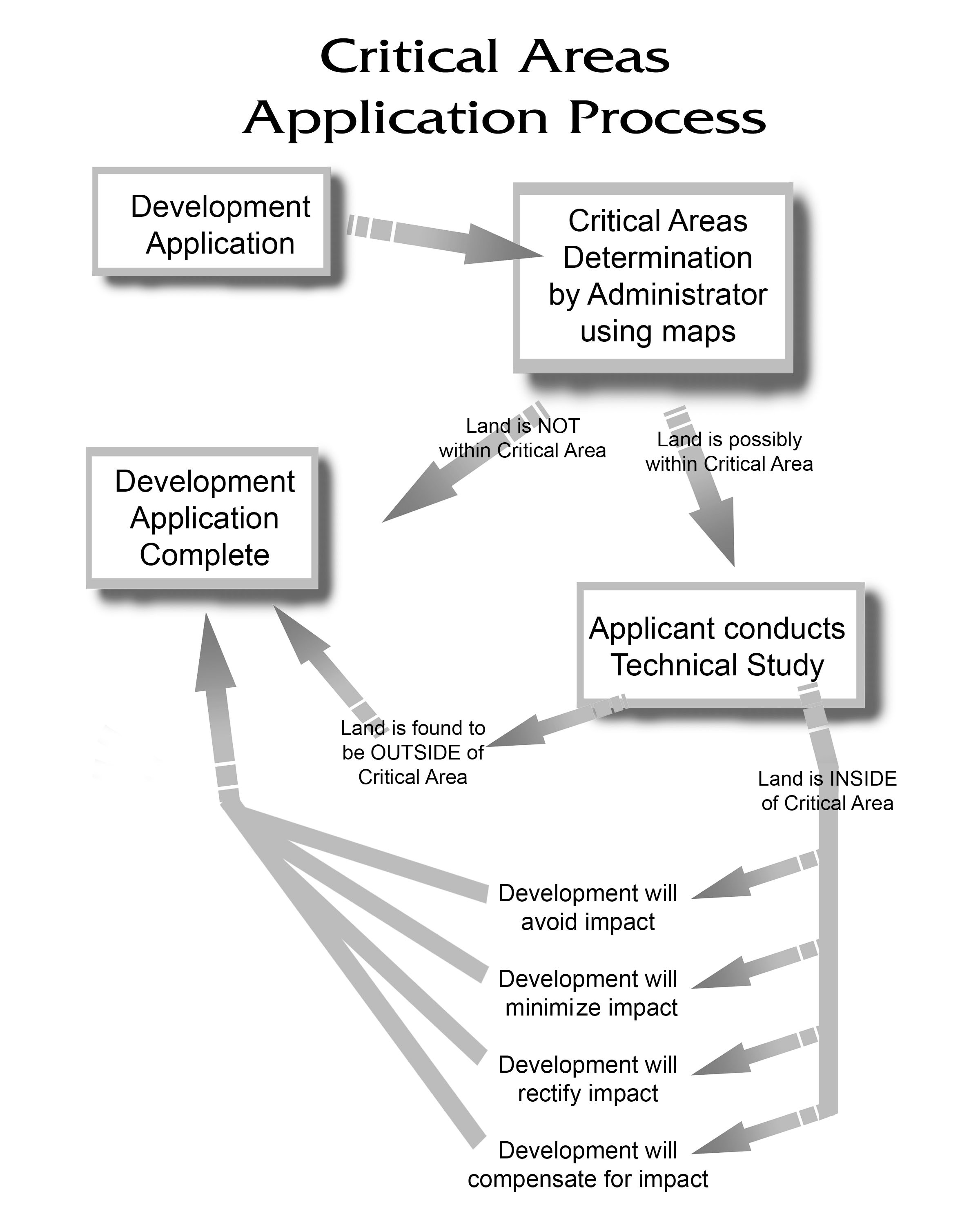
18.08.100 Purpose, intent and applicability.
The purpose of this section is to designate, classify and protect the functions and values of critical areas in a manner consistent with state law while allowing for reasonable use of private property. By adopting this section, the city of Davenport acknowledges that critical areas provide a variety of important biological and physical functions that benefit the community and its residents or may pose a threat to human safety or property.
The critical area overlay zone consists of that area within 200 feet of designated wetlands (as designated in the national wetlands inventory, NWI), aquifer recharge areas, critical wildlife habitat (as identified by the U.S. Fish and Wildlife Service, the National Marine Fisheries Service, the Washington Department of Fish and Wildlife, the Department of Natural Resources and the Washington Conservation Commission), frequently flooded areas (within Zone A as shown on national flood insurance program maps) or geologically hazardous areas (as identified by the U.S. Geological Survey and the Department of Natural Resources). Any development proposed on a parcel of land within the critical area overlay zone shall be subject to project review as required in this section unless specifically exempted. For wetlands not found on the NWI they will require a critical area study identifying the limits of the critical area. (Ord. 1141 § 1, 2019; Ord. 1061 § 2.02.020, 2012).
18.08.110 Critical areas permit required.
A development permit shall be obtained before construction or development begins within any critical area. The permit shall be for all structures including manufactured homes, as set forth in the definitions, and for all development including fill and other activities, also as set forth in the definitions. Boundaries of a critical area must be clearly marked prior to construction activities. (Ord. 1141 § 1, 2019; Ord. 1061 § 2.02.030, 2012).
18.08.120 Application for a critical areas permit.
(a) For those projects determined by the city administrator or designee likely to have an impact to the critical areas, the applicant shall submit a technical study identifying the precise limits of the critical area and its function and resource value as part of the application. The study shall be prepared by experts with demonstrated qualifications in the area of concern and shall apply best available science as part of its analysis.
(b) The following activities shall be allowed in critical areas without a critical areas permit provided they are conducted using best management practices and at a time and in a manner designed to minimize adverse impacts to the critical area:
(1) Conservation or preservation of soil, water, vegetation, fish, shellfish and other wildlife;
(2) Outdoor recreational activities which do not involve disturbance of the resource or site area, including fishing, hunting, bird watching, hiking, horseback riding and bicycling;
(3) Harvesting wild crops in a manner that is not injurious to the natural reproduction of such crops and provided the harvesting does not require tilling of soil, planting of crops or alteration of the resource by changing existing topography, vegetation, water conditions or water sources;
(4) Education, scientific research and use of nature trails;
(5) Existing and ongoing agriculture activities, including farming, horticulture, aquaculture, irrigation, ranching or grazing of animals;
(6) Normal and routine maintenance of legally constructed irrigation and drainage ditches;
(7) Normal and routine maintenance, repair or operation of existing serviceable structures, facilities or improved areas, not including expansion, change in character or scope or construction of a maintenance road;
(8) Minor modification (such as modification of a patio, balcony or second story) of existing serviceable structures where the modification does not adversely impact the functions of the critical area.
(c) The city requires applicants to demonstrate that development on a site determined to have critical areas will protect the resource by taking one of the following steps (listed in order of preference):
(1) Avoid impacts to the resource altogether.
(2) Minimize the impact by limiting the degree or magnitude of the action and its implementation by using appropriate technology, or by taking affirmative steps to avoid or reduce impacts.
(3) Rectify the impact by repairing, rehabilitating or restoring the affected environment to the conditions existing at the time of the initiation of the project.
(4) Reduce or eliminate the impact over time by preservation and maintenance operations during the life of the action.
(5) Compensate for the impact by replacing, enhancing or providing substitute resources or environments.
(6) Monitoring the impact and taking appropriate corrective measures.
(d) If critical resources are on the property that is being developed in the city and that lot crosses a jurisdictional line, the city of Davenport shall coordinate with Lincoln County in the review of the project.
(e) Application for a critical areas permit shall be made on forms furnished by the city of Davenport and may include, but not be limited to, plans in duplicate drawn to scale showing the nature, location, dimensions, and elevations of the area in question; existing or proposed structures, fill, storage of materials, drainage facilities, and the location of the foregoing. Required information specific to each particular type of critical area is listed in those critical area sections later in this chapter.
(f) If a project report is required for a development permit, the following information is required:
(1) Elevation in relation to mean sea level of the lowest floor (including basement) of all structures;
(2) Elevation in relation to mean sea level to which any structure has been flood proofed;
(3) Certification by a registered professional engineer or architect that the flood-proofing methods for any nonresidential structure meet the flood-proofing criteria in the floodways; and
(4) Description of the extent to which a watercourse will be altered or relocated as a result of proposed development.
(Ord. 1141 § 1, 2019; Ord. 1061 § 2.02.040, 2012).
18.08.130 Designation of local administrator.
The administrator is hereby appointed to administer and implement this chapter by granting or denying critical areas permit applications in accordance with its provisions. (Ord. 1141 § 1, 2019; Ord. 1061 § 2.02.050, 2012).
18.08.140 Duties and responsibilities of local administrator.
Duties of the administrator shall include, but not be limited to:
(a) Permit Review.
(1) Review all critical areas permits to determine that the permit requirements of this chapter have been satisfied.
(2) Review all critical areas permits to determine that all necessary permits have been obtained from those federal, state, or local governmental agencies from which prior approval is required.
(3) Review all critical areas permits to determine if the proposed development is located within a critical area. (Ord. 1141 § 1, 2019; Ord. 1061 § 2.02.060, 2012).
18.08.150 Record of notice.
All designated critical areas shall be recorded on all documents of title of record for all affected property. (Ord. 1141 § 1, 2019; Ord. 1061 § 2.02.070, 2012).
Article III. Variance Procedure
18.08.160 Appeal board.
(a) The city council as established by the city of Davenport shall hear and decide appeals and requests for variances from the requirements of this chapter.
(b) The city council shall hear and decide appeals when it is alleged there is an error in any requirement, decision, or determination made by the administrator in the enforcement or administration of this chapter.
(c) Those aggrieved by the decision of the city council, or any taxpayer, may appeal such decision to a court of record. (Ord. 1141 § 1, 2019; Ord. 1061 § 3.01.010, 2012).
18.08.170 Conditions for variances.
(a) Generally, the only condition under which a variance from the elevation standard may be issued is for new construction and substantial improvements to be erected on a lot of one-half acre or less in size contiguous to and surrounded by lots with existing structures constructed below the base flood level. As the lot size increases the technical justification required for issuing the variance increases.
(b) Variances may be issued for the reconstruction, rehabilitation, or restoration of structures listed on the National Register of Historic Places or the state inventory of historic places, without regard to the procedures set forth in this section.
(c) Variances shall not be issued within a designated floodway if any increase in flood levels during the base flood discharge would result.
(d) Variances shall only be issued upon a determination that the variance is the minimum necessary, considering the flood hazard, to afford relief.
(e) Variances shall only be issued upon:
(1) A showing of good and sufficient cause;
(2) A determination that failure to grant the variance would result in exceptional hardship to the applicant;
(3) A determination that the granting of a variance will not result in increased flood heights, additional threats to public safety, extraordinary public expense, create nuisances, cause fraud on or victimization of the public, or conflict with existing local laws or ordinances;
(4) A demonstration that no net loss of critical areas functions and values will occur as a result.
(f) Variances as interpreted in the National Flood Insurance Program are based on the general zoning law principle that they pertain to a physical piece of property; they are not personal in nature and do not pertain to the structure, its inhabitants, economic or financial circumstances. They primarily address small lots in densely populated residential neighborhoods. As such, variances from the flood elevations should be quite rare.
(g) Variances may be issued for nonresidential buildings in very limited circumstances to allow a lesser degree of floodproofing than watertight or dry floodproofing, where it can be determined that such action will have low damage potential, complies with all other variance criteria except subsection (a) of this section, and otherwise complies with sections (A), (C), and (D) of the FEMA General Standards.
(h) Any applicant to whom a variance is granted shall be given written notice that the structure will be permitted to be built with a lowest floor elevation below the base flood elevation and that the cost of flood insurance, if applicable, will be commensurate with the increased risk resulting from the reduced lowest floor elevation. (Ord. 1141 § 1, 2019; Ord. 1061 § 3.01.020, 2012).
Article IV. Determination of Consistency
18.08.180 Development of regulated activity – Determination of consistency required.
(a) Any proposed nonexempt land use development or activity requires the applicant to complete a critical areas permit application. The application shall include the following:
(1) A scaled drawing of the site and the proposed development;
(2) Identification of the site location by section, township and range;
(3) The general location of all existing land uses, structures, public and private access roads;
(4) A completed SEPA checklist, if applicable; and
(5) Other applicable permit applications.
(b) An application shall be deemed complete only when all required information is furnished. The building inspector shall compare the site of the proposed development or activity against the critical areas maps so as to ascertain the following:
(1) If the proposed development or activity falls within or near any resource area;
(2) If the mapped resource exists;
(3) If the development is likely to have a significant adverse impact on the functions and values of the critical areas;
(4) If critical areas special study is required;
(5) If all necessary permits have been obtained from those federal, state or local governmental agencies from which prior approval is required;
(6) Upon completion of the initial review, the building inspector shall determine whether the development as proposed is consistent with the standards set forth in this chapter. If the development as proposed is found to be consistent, a determination of consistency shall be issued.
(c) If a determination of consistency cannot be issued, the applicant is required to submit a development checklist which shall contain the following information:
(1) Legal description of the land, and assessor’s parcel number.
(2) As defined herein, the location of the following, if applicable:
(A) Wetlands;
(B) Aquifer recharge areas;
(C) Geologically hazardous areas;
(D) Frequently flooded areas;
(E) Priority habitats;
(F) Prime agriculture lands;
(G) Forest resource lands;
(H) Mineral resource lands.
(3) Any voluntary methods or activities anticipated by the applicant pertaining to critical areas, including incentives being offered by local or state government.
(4) Duplicate plans drawn to scale showing the nature, location, dimensions and elevations of the area in question, including existing or proposed structures, estimated amount of fill material, drainage facilities, significant natural features, and the location of the above items, if applicable. Survey quality documents will not normally be required.
(5) The requirement for delineating the location of possible critical areas will be waived if field investigation by city staff indicated the following:
(A) Sufficient information exists for staff to estimate the boundaries of any critical areas without a delineation by the applicant; or
(B) No structures and uses, except for exempt activities, are proposed to be located within any possible critical area.
(6) Subject to field investigation by city staff, or other reliable and relevant information, the information submitted by the applicant shall be presumed valid for all purposes under this chapter.
(d) Upon review of the development checklist, the building inspector shall determine whether the development as proposed is consistent with the standards set forth in this chapter and, if so, a determination of consistency shall be issued. If the development is still likely to have a significant impact on the functions of the resource, the applicant is required to conduct a critical areas special study. (Ord. 1141 § 1, 2019; Ord. 1061 § 4.01.010, 2012).
18.08.190 Critical areas special study – Requirements.
The purpose of the critical areas special study is to adequately evaluate the proposal and all potential significant impacts on the resource. The study may be included as part of the environmental review process under the SEPA as administrated by the city of Davenport, in accordance with the provisions of this chapter.
The study shall be performed by a professional who is licensed or qualified as an expert in the resources at issue. The study shall include the following when applicable:
(1) The resume of the principal author(s) which disclose(s) their technical training and experience and demonstrates their stature as a qualified professional;
(2) Identification and characterization of the critical area resource(s);
(3) An assessment of any potential hazards associated with the proposed development;
(4) An assessment of the impacts of the development proposal on any critical area resource(s);
(5) A mitigation plan which reduces impacts to an insignificant level and specifies maintenance, monitoring and bonding measures (where necessary);
(6) Any other site analysis and/or development plans specifically listed under the resource sections. (Ord. 1141 § 1, 2019; Ord. 1061 § 4.01.020, 2012).
18.08.200 Issuance.
A determination of consistency will be issued when it can be demonstrated, and the city finds, that:
(1) After consideration of all feasible best management practices, including alternative designs, scale (size), locations, and management plan, the proposed development meets the standards of this chapter, protects the function and values of resource lands and critical areas, and the required mitigation reduces impacts to insignificant levels on an individual and/or cumulative project basis; or
(2) Significant impact to critical areas function and values are both unavoidable and necessary because of public health and safety, or specific local or regional economic consideration which override the public interest in the protection of critical areas, or because all reasonable economic uses for the property would be denied as a result of circumstances peculiar to the subject property; and all unavoidable significant impacts shall be offset by enhancement of other critical areas on- or off-site. (Ord. 1141 § 1, 2019; Ord. 1061 § 4.01.030, 2012).
18.08.210 Issuance – General requirements – Property owner.
Upon the issuance of a determination of consistency, the owner of any property wholly or partially within a critical area on which a regulated activity is undertaken or proposed shall record a notice of critical area protection with the administrator. The notice is to identify the presence of a critical area resource and buffer, the application of this chapter to the property, and that limitations on action in or affecting such critical areas and buffers may exist.
The form of the notice shall be provided by the administrator and shall contain, at a minimum, a description of the specific resource protected, i.e., wetland, riparian corridor, and a map or legal description which identifies the resource boundary and the gross acreage within it. For the purposes of assessment, the filing of such a notice shall also designate the critical area resource and buffer lands eligible for reduced tax assessments.
The notice shall run with the land and failure to provide such notice to any purchaser prior to transferring any interest in the property shall be a violation of this chapter.
Prior to commencing construction activities on a development site, the applicant shall mark, as is required by the city, the boundary of designated critical area resources in a highly visible manner, with an item such as, but not limited to, yellow caution tape. These areas must remain so marked until all construction activities in the vicinity of the sensitive area are completed. All development related activities must stay outside the marked boundary.
Performance and maintenance bonds or other forms of surety may be required to insure the completion of mitigation, restoration, enhancement or remediation requirements associated with any development impacting a critical areas resource. (Ord. 1141 § 1, 2019; Ord. 1061 § 4.01.040, 2012).
18.08.220 Appeal of decision from building inspector.
An applicant or any person may appeal the building inspector’s decision to:
(1) Require or not require a special study;
(2) Issue or issue with conditions a determination of consistency;
(3) Deny the issuance of a determination of consistency;
(4) Extend or deny the extension of a determination of consistency.
The written appeal shall be made to the building inspector within 10 working days from the date of the action. The appeal shall state clearly the resource issue and the specific findings or element of the action which is being contested.
The building inspector shall convene a review committee of resource agency representatives and the appellant no more than 21 working days from the date of the filing of an appeal with the administrator. The review committee shall review the decision of the building inspector relative to the issues on appeal. The review committee shall support the original determination or recommend changes in writing to the building inspector within seven working days of convening.
The final determination of the review committee may be appealed to the board of adjustment within 20 working days of the building inspector’s receipt of the review committee’s determination. (Ord. 1141 § 1, 2019; Ord. 1061 § 4.01.050, 2012).
18.08.230 Term – Extension requirements.
The determination of consistency shall be valid for two years from the date of issuance. An extension of the determination of consistency shall not be required when substantial construction of the development has occurred within two years of issuance. Upon demonstration that the applicant has been diligently seeking required permits, a one-year extension of the determination of consistency will be granted upon request of the original permit holder or successor in title.
When neither substantial construction nor diligence in seeking permits can be demonstrated, then prior to the granting of each one-year extension, the building inspector shall review the original findings and may require updated information and/or assistance from persons or agencies having technical expertise. The building inspector may require additional mitigation measures in order to extend the determination, if the circumstances at the time of the original findings have been altered, or if the applicant has failed to abide by the terms of the original determination. (Ord. 1141 § 1, 2019; Ord. 1061 § 4.01.060, 2012).
18.08.240 Suspension, revocation.
The administrator may suspend or revoke a permit if it finds that the applicant has not complied with the conditions or limitations set forth in the permit or has exceeded the scope of the work set forth in the permit. The administrator shall cause notice of the denial, issuance, conditional issuance, revocation, or suspension of a permit to be published in a timely manner in a daily or weekly newspaper having a broad circulation in the area wherein the wetland lies. (Ord. 1141 § 1, 2019; Ord. 1061 § 4.01.070, 2012).
18.08.250 Nonconforming activities.
A regulated activity that was lawful before the passage of the ordinance codified in this chapter, but which is not in conformity with the provisions of this chapter, may be continued subject to the following:
(1) No such structure or use shall be expanded, changed, enlarged, or altered in any way that increases its nonconforming character relative to the provisions of this chapter without securing a conditional use permit, except as specifically authorized in subsections (2) and (3) of this section.
(2) Final plat approvals, conditional use permits, and building permits issued before the effective date of the ordinance amendment codified in this chapter will continue to be controlled by the version of this chapter in effect at the time of their final approval/permit issuance.
(3) In the event that a structure defined as nonconforming relative to provisions of this chapter is destroyed by fire or remodeled, it may be rebuilt in such a way that does not increase the nonconformity, but such rebuilding or remodeling shall not trigger a requirement for restoration of wetlands, streams, or buffers that were altered in a way that was legal at the time of their alteration. (Ord. 1141 § 1, 2019; Ord. 1061 § 4.01.080, 2012).
18.08.260 Reasonable use exception.
“Reasonable use” means the minimum use to which a property owner is entitled under applicable state and federal constitutional provisions, including takings and substantive due process. Reasonable use shall be liberally construed to protect the constitutional property rights of the applicant. A reasonable use exemption may only be secured by using the city’s conditional use process.
A reasonable use exemption may be secured only if:
(1) The strict application of the CAO would deny reasonable use of the property.
(2) There is no other reasonable use that would result in less impact on the critical area.
(3) Any alterations permitted to the critical area shall be the minimum necessary to allow for reasonable use of the property. (Ord. 1141 § 1, 2019; Ord. 1061 § 4.01.090, 2012).
18.08.270 Relief.
If application of the requirements in this section would deny all reasonable economic use of the lot, development will be permitted if the applicant demonstrates all of the following to the satisfaction of the city as part of the critical area permit in addition to demonstrating all of the findings required of variances from provisions of the zoning ordinance:
(1) There is no other reasonable use or feasible alternative to the proposed development with less impact on the critical area.
(2) The proposed development does not pose a threat to the public health, safety and welfare on or off of the subject property.
(3) Any alterations permitted to the requirements of this section shall be the minimum necessary to allow for reasonable use of the property.
(4) The inability of the applicant to derive reasonable economic use of the property is not the result of actions by the applicant in subdividing the property or adjusting a boundary line and creating the undevelopable condition after the effective date of the ordinance codified in this section.
(5) The proposal mitigates the impact on the critical area to the maximum extent possible. (Ord. 1141 § 1, 2019; Ord. 1061 § 4.01.100, 2012).
18.08.280 Mitigation.
Mitigation shall be required in the following order of preference:
(1) Avoiding the impact altogether by not taking a certain action or parts of an action;
(2) Minimizing impacts by limiting the degree or magnitude of the action and its implementation, by using appropriate technology, or by taking affirmative steps, such as project redesign, relocation, or timing, to avoid or reduce impacts;
(3) Rectifying the impact to wetlands, critical aquifer recharge areas, frequently flooded areas, and habitat conservation areas by repairing, rehabilitating, or restoring the affected environment to the historical conditions or the conditions existing at the time of the initiation of the project;
(4) Minimizing or eliminating the hazard by restoring or stabilizing the hazard area through engineered or other methods;
(5) Reducing or eliminating the impact or hazard over time by preservation and maintenance operations during the life of the action;
(6) Compensating for the impact to wetlands, critical aquifer recharge areas, frequently flooded areas, and habitat conservation areas by replacing, enhancing, or providing substitute resources or environments;
(7) Monitoring the hazard or other required mitigation and taking remedial action when necessary; and
(8) Mitigation for individual actions may include a combination of the above measures. (Ord. 1141 § 1, 2019; Ord. 1061 § 4.01.110, 2012).
18.08.290 Enforcement.
The methods of enforcement of critical area protection shall include inspections, reporting requirements, bonds, permit revocation, civil penalties, and abatement. (Ord. 1141 § 1, 2019; Ord. 1061 § 4.01.120, 2012).
18.08.300 Notification.
Property owners with land adjacent to critical areas must be notified of critical area buffers on their lands. (Ord. 1141 § 1, 2019; Ord. 1061 § 4.01.130, 2012).
Article V. Wetlands
18.08.310 Designation.
“Wetlands” are areas that are inundated or saturated by surface water or ground water at a frequency and duration sufficient to support, and that under normal circumstances do support, a prevalence of vegetation typically adapted for life in saturated soil conditions. Wetlands generally include swamps, marshes, bogs, and similar areas. Wetlands do not include those artificial wetlands intentionally created from nonwetland sites, including, but not limited to, irrigation and drainage ditches, grass-lined swales, canals, detention facilities, wastewater treatment facilities, farm ponds, and landscape amenities, or those wetlands created after July 1, 1990, that were unintentionally created as a result of the construction of a road, street, or highway. Wetlands may include those artificial wetlands intentionally created from nonwetland areas to mitigate conversion of wetlands. Emergent wetlands are regulated wetlands with at least 30 percent of the surface area covered by erect, rooted, herbaceous vegetation extending above the water surface as the uppermost vegetative strata.
Wetlands regulated under development regulations adopted pursuant to Chapter 36.70A RCW shall be delineated in accordance with the manual adopted by the department pursuant to RCW 90.58.380. (Ord. 1141 § 1, 2019; Ord. 1061 § 5.01.000, 2012).
18.08.320 Determination.
(a) The existence of a wetland and the location of its boundary shall be determined by the applicant through the performance of a field investigation applying a methodology acceptable to the U.S. Army Corps of Engineers or Washington Department of Ecology. Qualified professionals shall perform wetland determinations and delineations using the acceptable methodology.
(b) Wetlands shall be rated according to the Washington State Wetland Rating System for Eastern Washington: 2014 Update (Ecology Publication No. 14-0-030, or as revised and approved by Ecology), which contains the definitions and methods for determining whether the criteria below are met.
|
Wetland Category |
Description |
|---|---|
|
Category I |
(1) Alkali wetlands; (2) wetlands of high conservation value that are identified by scientists of the Washington Natural Heritage Program/DNR; (3) bogs and calcareous fens; (4) mature and old-growth forested wetlands over one-quarter acre with slow-growing trees; (5) forests with stands of aspen; and (6) wetlands that perform many functions very well (scores between 22 – 27 points). These wetlands are those that (1) represent a unique or rare wetland type; or (2) are more sensitive to disturbance than most wetlands; (3) are relatively undisturbed and contain ecological attributes that are impossible to replace within a human lifetime; or (4) provide a high level of function. |
|
Category II |
(1) Forested wetlands in the floodplain of rivers; (2) vernal pools; and (3) wetlands that perform functions well (scores between 19 – 21 points). These wetlands are difficult, though not impossible, to replace and provide high levels of some functions. These wetlands occur more commonly than Category I wetlands but still need a relatively high level of protections. |
|
Category III |
These wetlands have a moderate level of functions (scores between 16 – 18 points). These wetlands can be often adequately replaced with a well-planned mitigation project. Wetlands scoring between 16 – 18 points generally have been disturbed in some ways and are often less diverse or more isolated from other natural resources in the landscape than Category II wetlands. |
|
Category IV |
These wetlands have the lowest level of functions (scores fewer than 16 points) and are often heavily disturbed. |
(c) Development near wetlands shall observe the following setbacks from the edge of the wetland. No development or activity shall occur within the required setbacks unless the applicant can demonstrate that the proposed use or activity will not degrade the functions and values of the wetland and other critical areas according to the evaluation criteria from subsection (e) of this section. In no case shall any development or activity be permitted closer to the edge of the wetland than within one-half of the required setback.
|
Wetland Category |
Setback |
|---|---|
|
Category I |
250 feet |
|
Category II |
200 feet |
|
Category III |
150 feet |
|
Category IV |
50 feet |
(d) Buffer zones may be increased if the city council finds, on a case-by-case basis and based upon best available science, at least one of the following applies:
(1) A larger buffer is necessary to maintain viable populations of existing species; or
(2) The wetlands are used by species proposed or listed by the federal government or the state as endangered, threatened, rare, sensitive or being monitored as habitat for those species or as unusual nesting or resting sites; or
(3) The adjacent land is susceptible to severe erosion and erosion control measures will not effectively prevent adverse wetland impacts; or
(4) The adjacent land has minimal vegetative cover or slopes greater than 25 percent.
(e) Buffer zones may be decreased to no less than 25 feet if the city council finds, on a case-by-case basis and based upon best available science, that all of the following apply:
(1) The critical area report provides a sound rationale for a reduced buffer; and
(2) The existing buffer area is well-vegetated with native species and has less than 10 percent slopes; and
(3) No direct or indirect, short-term or long-term adverse impact to the wetland will result from the proposed activity.
(f) Wetland buffer areas may be used for conservation and restoration activities, passive recreation (including trails, wildlife viewing structures and fishing access areas) and stormwater management facilities.
(g) If activities result in the loss or degradation of a regulated wetland or buffer, a mitigation or enhancement plan prepared by a qualified expert shall be submitted for review and approval by the city. Any mitigation or replacement wetland shall be located in the same watershed as the impacted wetland(s) of the same category and shall comply with the following ratios (new wetland area to that impacted by the proposal):
|
Category and Type of Wetland |
Creation or Reestablishment |
Rehabilitation |
Enhancement |
|---|---|---|---|
|
Category I: Bog, Natural Heritage Site |
Not considered possible |
Case by case |
Case by case |
|
Category I: Mature Forested |
6:1 |
12:1 |
24:1 |
|
Category I: Based on Functions |
4:1 |
8:1 |
16:1 |
|
Category II |
3:1 |
6:1 |
12:1 |
|
Category III |
2:1 |
4:1 |
8:1 |
|
Category IV |
1.5:1 |
3:1 |
6:1 |
(Ord. 1141 § 1, 2019; Ord. 1061 § 5.01.010, 2012).
18.08.330 Aquifer protection areas.
“Aquifer protection areas” designated as high susceptibility for aquifer contamination are those areas which lie within the A zone on the FEMA maps. All development and all uses which lie within these areas shall be connected to the city’s sewer system. No new uses on a septic system are permitted in high susceptibility areas of critical aquifer recharge.
(1) In areas designated as high susceptibility for aquifer contamination, all uses shall be connected to the city’s sewer system. No new uses on a septic system are permitted in high susceptibility areas of critical aquifer recharge.
(2) For uses locating within the critical aquifer recharge area and requiring site plan review, a disclosure form indicating activities and hazardous materials that will be used shall be provided for review and approval.
(3) Impervious surfaces shall be minimized within the critical aquifer recharge areas.
(4) Best management practices as defined by state and federal regulations shall be followed by commercial and industrial uses located in the critical aquifer recharge areas to ensure that potential contaminants do not reach the aquifer.
(5) A spill prevention and emergency response plan shall be prepared and submitted for review and approval by the city and fire district. (Ord. 1141 § 1, 2019; Ord. 1061 § 5.01.020, 2012).
18.08.340 Aquifer protection area designations.
The city, through this section, hereby designates two categories for aquifer recharge areas. These categories are designated to assist the administrator in determining the level of assessment necessary to evaluate specific land use proposals. The categories are based on the determination that certain areas require additional scrutiny of the potential impacts of a proposed land use with consideration given to hydrogeologic vulnerability. All designated areas are subject to change as data and information are updated or become available. (Ord. 1141 § 1, 2019; Ord. 1061 § 5.01.030, 2012).
18.08.350 Designation categories.
Category I areas are those so designated because of the need to provide them special protection due to a specific preexisting land use, or because they are identified by the city, county, state or federal government as areas in need of special aquifer protection where a proposed land use may pose a potential risk which increases aquifer vulnerability.
Category I includes areas served by ground water which have been designated as a sole source aquifer area under the federal Safe Drinking Water Act; areas identified within a closed or low-flow stream watershed designated by the Department of Ecology pursuant to Chapter 90.22 RCW; and areas designated as wellhead protection areas pursuant to WAC 246-290-135(3) and the ground water contribution area in WAC 246-290-135(4).
Wellhead protection areas shall, for the purpose of this regulation, include the identified recharge areas associated with either group A public water supply wells, those group B wells with a wellhead protection plan filed with the Lincoln County Health Department, or plats served by five or more individual wells where the average lot size is equal to or less than two acres for which a wellhead protection plan has been completed and filed with the Lincoln County Health Department. Category I areas are shown on the aquifer recharge area map.
Category II is designated as areas throughout the city not identified as Category I areas.
When any portion of the proposed project area lies partly within a Category I area, the proposed project shall be subject to the level of scrutiny provided for a Category I area. (Ord. 1141 § 1, 2019; Ord. 1061 § 5.01.040, 2012).
18.08.360 Applicability.
All development projects are subject to the provisions of this section except for the following:
(1) Existing activities that currently and legally exist at the time this section became effective. However, expansions or changes in use are subject to this section and the review process contained herein.
(2) Single-family residential building permits, including accessory building permits, which are outside Category I areas.
(3) Residential short plats outside Category I areas where each lot is 2.5 acres or greater.
(4) Single-family residential building permits where a site assessment report was required to be completed for the land division, in which case, to meet the conditions of this exemption, the applicant must comply with the recorded plat notes and the applicable mitigations contained in the site assessment report. (Ord. 1141 § 1, 2019; Ord. 1061 § 5.01.050, 2012).
18.08.370 Prohibited uses.
The following activities are prohibited in Category I areas due to the probability and/or potential magnitude of their adverse effects on ground water:
(1) Landfill activities as defined in Chapters 173-304 and 173-351 WAC;
(2) Class V injection wells, including:
(A) Agricultural drainage wells;
(B) Untreated sewage waste disposal wells;
(C) Cesspools;
(D) Industrial process water and disposal wells;
(3) Radioactive waste disposal; and
(4) Radioactive disposal sites. (Ord. 1141 § 1, 2019; Ord. 1061 § 5.01.060, 2012).
18.08.380 Critical aquifer recharge areas (CARAs).
“Critical aquifer recharge areas” are Category 1 areas designated by WAC 365-190-080(2) that are determined to have a critical recharging effect on aquifers used for potable water as defined by WAC 365-190-030(2). Critical aquifer recharge areas have prevailing geologic conditions associated with infiltration rates that create a high potential for contamination of ground water resources or contribute significantly to the replenishment of ground water. (Ord. 1141 § 1, 2019; Ord. 1061 § 5.01.070, 2012).
18.08.390 Prohibited activities.
Prohibited activities in Category I areas:
(1) Mining.
(A) Metals and hard rock mining.
(B) Sand and gravel mining are prohibited in critical aquifer recharge areas determined to be highly susceptible or vulnerable unless a stormwater quality management plan is approved by the city council.
(2) Wood Treatment Facilities. Wood treatment facilities that allow any portion of the treatment process to occur over permeable surfaces (both natural and manmade).
(3) Other Prohibited Uses or Activities.
(A) Activities that would significantly reduce the recharge to aquifers currently or potentially used as a potable water source;
(B) Activities that would significantly reduce the recharge to aquifers that are a source of significant base-flow to a regulated stream; and
(C) Activities that are not connected to an available sanitary sewer system are prohibited from critical aquifer recharge areas associated with sole source aquifers. (Ord. 1141 § 1, 2019; Ord. 1061 § 5.01.080, 2012).
18.08.400 Performance standards – General requirements.
Activities may only be permitted in a critical aquifer recharge area if the applicant can show that the proposed activity will not cause contaminants to enter the aquifer and that the proposed activity will not adversely affect the recharging of the aquifer.
The proposed activity must comply with the water source protection requirements and recommendations of the U.S. Environmental Protection Agency, Washington State Department of Health, and the Lincoln County Health Department. (Ord. 1141 § 1, 2019; Ord. 1061 § 5.01.090, 2012).
18.08.410 Performance standards – Specific uses.
(a) Storage Tanks. All storage tanks proposed to be located in a critical aquifer recharge area must comply with local building code requirements and must conform to the following requirements:
(1) Underground Tanks. All new underground storage facilities proposed for use in the storage of hazardous substances or hazardous wastes shall be designed and constructed so as to:
(A) Prevent releases due to corrosion or structural failure for the operational life of the tank;
(B) Be protected against corrosion, constructed of noncorrosive material, steel clad with a noncorrosive material, or designed to include a secondary containment system to prevent the release or threatened release of any stored substances;
(C) Use material in the construction or lining of the tank that is compatible with the substance to be stored.
(b) Above-Ground Tanks. All new above-ground storage facilities proposed for use in the storage of hazardous substances or hazardous wastes shall be designed and constructed so as to:
(1) Not allow the release of a hazardous substance to the ground, ground waters, or surface waters;
(2) Have a primary containment area enclosing or underlying the tank or part thereof; and
(3) A secondary containment system either built into the tank structure or a dike system built outside the tank for all tanks.
(c) Vehicle Repair and Servicing.
(1) Vehicle repair and servicing must be conducted over impermeable pads and within a covered structure capable of withstanding normally expected weather conditions. Chemicals used in the process of vehicle repair and servicing must be stored in a manner that protects them from weather and provides containment should leaks occur.
(2) No dry wells shall be allowed in critical aquifer recharge areas on sites used for vehicle repair and servicing. Dry wells existing on the site prior to facility establishment must be abandoned using techniques approved by the Washington Department of Ecology prior to commencement of the proposed activity.
(d) Use of reclaimed water for surface percolation or direct recharge. Water reuse projects for reclaimed water must be in accordance with the adopted water or sewer comprehensive plans that have been approved by the state Departments of Ecology and Health.
(e) Use of reclaimed water for surface percolation must meet the ground water recharge criteria given in RCW 90.46.010(10) and 90.46.080(1). The Department of Ecology may establish additional discharge limits in accordance with RCW 90.46.080(2).
(f) Direct injection must be in accordance with the standards developed by authority of RCW 90.46.042.
(g) State and Federal Regulations. The uses listed below shall be conditioned as necessary to protect critical aquifer recharge areas in accordance with the applicable state and federal regulations. (Ord. 1141 § 1, 2019; Ord. 1061 § 5.01.100, 2012).
Article VI. Critical Wildlife Habitat
18.08.420 Fish and wildlife habitat conservation areas.
Fish and wildlife habitat conservation areas include:
(1) Areas with which state or federally designated endangered, threatened, and sensitive species have a primary association.
(A) Federally designated endangered and threatened species are those fish and wildlife species identified by the U.S. Fish and Wildlife Service and the National Marine Fisheries Service that are in danger of extinction or threatened to become endangered. The U.S. Fish and Wildlife Service and the National Marine Fisheries Service should be consulted for current listing status.
(B) State designated endangered, threatened, and sensitive species are those fish and wildlife species native to the state of Washington identified by the Washington Department of Fish and Wildlife that are in danger of extinction, threatened to become endangered, vulnerable, or declining and are likely to become endangered or threatened in a significant portion of their range within the state without cooperative management or removal of threats. State designated endangered, threatened, and sensitive species are periodically recorded in WAC 232-12-014 (state endangered species) and WAC 232-12-011 (state threatened and sensitive species). The state Department of Fish and Wildlife maintains the most current listing and should be consulted for current listing status.
(2) State Priority Habitats and Areas Associated with State Priority Species. Priority habitats and species are considered to be priorities for conservation and management. Priority species require protective measures for their perpetuation due to their population status, sensitivity to habitat alteration, and/or recreational, commercial, or tribal importance. Priority habitats are those habitat types or elements with unique or significant value to a diverse assemblage of species. A priority habitat may consist of a unique vegetation type or dominant plant species, a described successional stage, or a specific structural element. Priority habitats and species are identified by the state Department of Fish and Wildlife and may be designated as appropriate through the process detailed in DMC 18.08.430.
(3) Habitats and Species of Local Importance. Habitats and species of local importance are those identified by the city, including but not limited to those habitats and species that, due to their population status or sensitivity to habitat manipulation, warrant protection. Habitats may include a seasonal range or habitat element with which a species has a primary association, and which, if altered, may reduce the likelihood that the species will maintain and reproduce over the long term. (Ord. 1141 § 1, 2019; Ord. 1061 § 6.01.010, 2012).
18.08.430 Designation process.
The city shall consider nominations for habitat areas and species to be designated as locally important on an annual basis, following the procedures set forth in the city comprehensive plan.
(1) Habitats and species to be designated shall exhibit the following characteristics:
(A) Local populations of native species are in danger of extirpation based on existing trends:
(B) Local populations of native species that are likely to become endangered;
(C) Local populations of native species that are vulnerable or declining;
(D) The species or habitat has recreation, commercial, game, tribal, or other special value;
(E) Long-term persistence of a species is dependent on the protection, maintenance, and/or restoration of the nominated habitat;
(F) Protection by other county, state, or federal policies, laws, regulations, or nonregulatory tools is not adequate to prevent degradation of the species or habitat in;
(G) Without protection, there is a likelihood that the species or habitat will be diminished over the long term; and
(H) Areas nominated to protect a particular habitat or species must represent either high-quality native habitat or habitat that has a high potential to recover to a suitable condition and which is of limited availability, highly vulnerable to alteration, or provides landscape connectivity which contributes to the integrity of the surrounding landscape.
(2) Habitats and species may be nominated for designation by any person. The nomination should indicate whether specific habitat features are to be protected (for example, nest sites, breeding areas, and nurseries), or whether the habitat or ecosystem is being nominated in its entirety. The nomination may include management strategies for the species or habitats. Management strategies must be supported by professional scientific analysis, and where restoration of habitat is proposed, a specific plan for restoration must be provided prior to nomination.
(3) The administrator shall determine whether the nomination proposal is complete and, if complete, shall evaluate it according to the characteristics enumerated in this section and make a recommendation to the city council based on those findings.
(4) The city council shall hold a public hearing for proposals found to be complete in accordance with city hearing procedures and make a recommendation to the city council based on the characteristics enumerated in this section.
(5) Following the recommendation of the city council, the administrator shall determine whether the nominated habitat or species shall be designated a habitat or species of local importance. Approved nominations will be subject to the provisions of this section (i.e., the species or habitat has recreation, commercial, game, tribal, or other special value).
(6) The following areas are designated as habitats of local importance:
(A) Naturally Occurring Ponds Under 20 Acres but Larger than 2,500 Square Feet. Naturally occurring ponds are those ponds under 20 acres and their submerged aquatic beds that provide fish or wildlife habitat, including those artificial ponds intentionally created from dry areas in order to mitigate impacts to ponds. Naturally occurring ponds do not include ponds deliberately designed and created from dry sites, such as canals, detention facilities, water or wastewater treatment facilities, farm ponds, temporary construction ponds, and landscape amenities, unless such artificial ponds were intentionally created for mitigation.
(B) Stream Designations. The following stream is hereby designated as an FWHCA for those stretches that are not in culverts or artificially created ditches as of December 31, 2003: Cottonwood Creek.
(C) Stream Buffers. Within the FWHCA 50-foot buffers, on each side of the creek, measured from the top of the bank, are hereby established, and therein: all new subdivisions of land must demonstrate that existing ecological functions and values of these streams and their buffers are at least maintained (and preferably enhanced).
(D) Lakes, ponds, streams, and rivers planted with game fish by a governmental or tribal entity.
(E) State Natural Area Preserves and Natural Resource Conservation Areas. Natural area preserves and natural resource conservation areas are defined and established by the Washington State Department of Natural Resources.
(F) Areas of Rare Plant Species and High-Quality Ecosystems. Areas of rare plant species and high-quality ecosystems are identified by the Washington State Department of Natural Resources through the Natural Heritage Program as designated.
(G) Land useful or essential for preserving connections between habitat blocks and open spaces as designated through the process detailed in this section.
(7) The applicant for development proposed in the critical areas overlay zone that may impact habitat conservation areas shall provide a habitat management plan, prepared by a qualified expert in the species in question, for evaluation by local, state and federal agencies.
(8) The habitat management plan shall be based on best available science and best management practices and shall be designed to achieve specific habitat objectives and shall include, at a minimum:
(A) A detailed description of vegetation on and adjacent to the project area;
(B) Identification of any species of local importance, priority species, or endangered, threatened, sensitive or candidate species that have a primary association with habitat on or adjacent to the project area, and assessment of potential project impacts to the use of the site by the species;
(C) A discussion of any federal, state or local special management recommendations, including Department of Fish and Wildlife habitat management recommendations, that have been developed for species or habitats located on or adjacent to the project area;
(D) A detailed discussion of the potential impact on habitat by the project, including potential impact to water quality;
(E) A discussion of measures, including avoidance, minimization and mitigation, proposed to preserve existing habitats and restore any habitat that was degraded prior to the current proposed land use activity;
(F) A discussion of continuing management practices that will protect habitat after the project site has been developed, including proposed monitoring and maintenance programs.
(9) A habitat conservation area may be altered only if the proposed alteration of the habitat or the mitigation proposed does not degrade the functions and values of the habitat.
(10) No plant, wildlife or fish species not indigenous to the region shall be introduced into a habitat conservation area unless authorized by a state or federal permit or approval.
(11) The habitat management plan shall address the project area of the proposed activity, all habitat conservation areas and recommended buffers within 300 feet of the project area and all other critical areas within 300 feet of the project area. (Ord. 1141 § 1, 2019; Ord. 1061 § 6.01.020, 2012).
Article VII. Frequently Flooded Areas
18.08.440 Designation.
“Frequently flooded areas” means lands in the floodplain subject to a one percent or greater chance of flooding in any given year. Frequently flooded areas perform important hydrologic functions and may present a risk to persons and property as designated by WAC 365-190-080(3). Classifications of frequently flooded areas include, at a minimum, the 100-year floodplain designations of the Federal Emergency Management Agency and the National Flood Insurance Program.
Applicants for development within frequently flooded areas shall comply with provisions of the city’s flood damage prevention ordinance. (Ord. 1141 § 1, 2019; Ord. 1061 § 7.01.010, 2012).
Article VIII. Geologically Hazardous Areas
18.08.450 Designation.
“Geologically hazardous areas” include areas susceptible to erosion, sliding, earthquake, or other geological events. They pose a threat to the health and safety of citizens when incompatible development is sited in areas of significant hazard. Such incompatible development may not only place itself at risk, but also may increase the hazard to surrounding development and use. Areas susceptible to one or more of the following types of hazards shall be designated as a geologically hazardous area per WAC 365-190-080(4)(a):
(1) Erosion hazard;
(2) Landslide hazard;
(3) Seismic hazard;
(4) Mine hazard;
(5) Volcanic hazard; and
(6) Other geological events including mass wasting, debris flows, rock falls, and differential settlement. (Ord. 1141 § 1, 2019; Ord. 1061 § 8.01.010, 2012).
18.08.460 Classification of geologically hazardous areas.
All geologic hazard areas should be classified according to the following categories for each geologic hazard type.
|
Classification |
Documentation and Data Sources |
|
Known or Suspected Risk |
Documentation or projection of the hazard by a qualified professional exists. |
|
Risk Unknown |
Documentation or projection of the lack of hazard by a qualified professional exists, or data is not available to determine the presence or absence of a geological hazard. |
(Ord. 1141 § 1, 2019; Ord. 1061 § 8.01.020, 2012).
18.08.470 Mapping of geologically hazardous areas.
The approximate location and extent of geologically hazardous areas are shown on the adopted critical areas maps. The adopted critical areas maps include:
(1) U.S. Geological Survey landslide hazard, seismic hazard, and volcano hazard maps;
(2) Washington State Department of Natural Resources slope stability maps;
(3) Federal Emergency Management Agency flood insurance maps;
(4) Maps included as Appendix B to the City Comprehensive Plan.
These maps are to be used as a guide for the city, project applicants, and/or property owners and may be continuously updated as new critical areas are identified. They are a reference and do not provide a final critical area designation. (Ord. 1141 § 1, 2019; Ord. 1061 § 8.01.030, 2012).
18.08.480 Allowed activities.
Activities allowed in geologically hazardous areas:
(1) Erosion and Landslide Hazard Areas. Except as otherwise provided for in this title, only those activities approved and permitted consistent with an approved critical area report in accordance with this title shall be allowed in erosion or landslide hazard areas.
(2) Seismic Hazard Areas. The following activities are allowed within seismic hazard areas:
(A) Construction of new buildings with less than 2,500 square feet of floor area or roof area, whichever is greater, and which are not residential structures or used as places of employment or public assembly;
(B) Additions to existing single-story residences that are 250 square feet or less; and
(C) Installation of fences.
(3) Volcanic Hazard Areas. The following activities are allowed within volcanic hazard areas:
(A) Construction of new buildings with less than 2,500 square feet of floor area or roof area, whichever is greater, and which are not residential structures or used as places of employment or public assembly;
(B) Additions to existing residences that are 250 square feet or less; and
(C) Installation of fences. (Ord. 1141 § 1, 2019; Ord. 1061 § 8.01.040, 2012).
18.08.490 Allowed activities – Other hazard areas.
The administrator may allow the following activities within other geologically hazardous areas, if the activity will not increase the risk of the hazard:
(1) Construction of new buildings with less than 2,500 square feet of floor area or roof area, whichever is greater, and which are not residential structures or used as places of employment or public assembly;
(2) Additions to existing residences that are 250 square feet or less; and
(3) Installation of fences. (Ord. 1141 § 1, 2019; Ord. 1061 § 8.01.050, 2012).
18.08.500 Critical areas report requirements.
A critical areas report for a geologically hazardous area shall be prepared by an engineer or geologist, licensed in the state of Washington, with experience analyzing geologic, hydrologic, and ground water flow systems, and who has experience preparing reports for the relevant type of hazard. (Ord. 1141 § 1, 2019; Ord. 1061 § 8.01.060, 2012).
18.08.510 Areas addressed in critical areas report.
The following areas shall be addressed in a critical areas report for geologically hazardous areas:
(1) The project area of the proposed activity;
(2) All geologically hazardous areas within 200 feet of the project area or that have potential to be affected by the proposal;
(3) The presence, nature, and location of wetlands, FWHCAs, and/or aquifer recharge zones. (Ord. 1141 § 1, 2019; Ord. 1061 § 8.01.070, 2012).
18.08.520 Performance standards.
(a) Alterations of geologically hazardous areas or associated buffers may only occur for activities that:
(1) Will not increase the threat of the geological hazard to adjacent properties beyond predevelopment conditions;
(2) Will not adversely impact other critical areas;
(3) Are designed so that the hazard to the project is eliminated or mitigated to a level equal to or less than predevelopment conditions; and
(4) Are certified as safe as designed and under anticipated conditions by a qualified engineer or geologist, licensed in the state of Washington.
(b) Critical facilities shall not be sited within geologically hazardous areas unless there is no other practical alternative. (Ord. 1141 § 1, 2019; Ord. 1061 § 8.01.080, 2012).
18.08.530 Performance standards – Specific hazards.
(a) Erosion and Landslide Hazard Areas. Activities on sites containing erosion or landslide hazards shall meet the requirements of DMC 18.08.520, Performance standards, and the specific following requirements:
(1) Buffer Requirement. A buffer shall be established from all edges of landslide hazard areas. The size of the buffer shall be determined by the administrator to eliminate or minimize the risk of property damage, death, or injury resulting from landslides caused in whole or part by the development, based upon review of and concurrence with a critical area report prepared by a qualified professional.
(2) Minimum Buffer. The minimum buffer shall be equal to the height of the slope or 50 feet, whichever is greater.
(3) Buffer Reduction. The buffer may be reduced to a minimum of 10 feet when a qualified professional demonstrates to the administrator’s satisfaction that the reduction will adequately protect the proposed development, adjacent developments, and uses, and the subject critical area.
(4) Increased Buffer. The buffer may be increased where the administrator determines a larger buffer is necessary to prevent risk of damage to proposed and existing development.
(b) Alterations. Alterations of an erosion or landslide hazard area and/or buffer may only occur for activities for which a hazards analysis is submitted and certifies that:
(1) The development will not increase surface water discharge or sedimentation to adjacent properties beyond predevelopment conditions;
(2) The development will not decrease slope stability on adjacent properties; and
(3) Such alterations will not adversely impact other critical areas.
(c) Design Standards. Development and land clearing within an erosion or landslide hazard area and/or buffer shall be designed to meet the following basic requirements unless it can be demonstrated that an alternative design that deviates from one or more of these standards provides greater long-term slope stability while meeting all other provisions of this title. The requirement for long-term slope stability shall exclude designs that require regular and periodic maintenance to maintain their level of function. The basic development design standards are:
(1) The proposed development shall not decrease the factor of safety for landslide occurrences below the limits of 1.5 for static conditions and 1.2 for dynamic conditions. Analysis of dynamic conditions shall be based on a minimum horizontal acceleration as established by the current version of the International Building Code;
(2) Structures and improvements shall be clustered to avoid geologically hazardous areas and other critical areas;
(3) Structures and improvements shall minimize alterations to the natural contour of the slope, and foundations shall be tiered where possible to conform to existing topography;
(4) Structures and improvements shall be located to preserve the most critical portion of the site and its natural landforms and vegetation;
(5) The proposed development shall not result in greater risk or a need for increased buffers on neighboring properties;
(6) The use of retaining walls that allow the maintenance of existing natural slope area is preferred over graded artificial slopes;
(7) Development shall be designed to minimize impervious lot coverage;
(8) Vegetation Retention. Unless otherwise provided or as part of an approved alteration, removal of vegetation from an erosion or landslide hazard area or related buffer shall be prohibited;
(9) Seasonal Restriction. Clearing shall be allowed only from May 1st to October 1st of each year; provided, that the city may extend or shorten the dry season on a case-by-case basis depending on actual weather conditions;
(10) Utility Lines and Pipes. Utility lines and pipes shall be permitted in erosion and landslide hazard areas only when the applicant demonstrates that no other practical alternative is available. The line or pipe shall be located above ground and properly anchored and/or designed so that it will continue to function in the event of an underlying slide. Stormwater conveyance shall be allowed only through a high-density polyethylene pipe with fuse-welded joints, or similar product that is technically equal or superior;
(11) Point Discharges. Point discharges from surface water facilities and roof drains onto or upstream from an erosion or landslide hazard area shall be prohibited except as follows:
(A) Conveyed via continuous storm pipe downslope to a point where there are no erosion hazard areas downstream from the discharge;
(B) Discharged at flow durations matching predeveloped conditions, with adequate energy dissipation, into existing channels that previously conveyed stormwater runoff in the predeveloped state;
(C) Dispersed discharge upslope of the steep slope onto a low-gradient undisturbed buffer demonstrated to be adequate to infiltrate all surface and stormwater runoff, and where it can be demonstrated that such discharge will not increase the saturation of the slope;
(12) Subdivisions. The division of land in landslide hazard areas and associated buffers is subject to the following:
(i) Land that is located wholly within a landslide hazard area or its buffer may not be subdivided. Land that is located partially within a landslide hazard area or its buffer may be divided; provided, that each resulting lot has sufficient buildable area outside of, and will not affect, the landslide hazard or its buffer;
(ii) Access roads and utilities may be permitted within the landslide hazard area and associated buffers if the city determines that no other feasible alternative exists; and
(iii) Prohibited Development. On-site sewage disposal systems, including drain fields, shall be prohibited within erosion and landslide hazard areas and related buffers.
(d) Seismic Hazard Areas. Activities proposed to be located in seismic hazard areas shall meet the requirements of DMC 18.08.520, Performance standards. (Ord. 1141 § 1, 2019; Ord. 1061 § 8.01.090, 2012).
Prior legislation: Ord. 737.