


DIVISION IV. SHORELINE MANAGEMENT
Chapter 14.34
SHORELINE MASTER PROGRAM
Sections:
Article I. General Provisions
14.34.040 Relationship to other regulations.
14.34.050 Liberal construction.
Article II. Definitions
Article III. Shoreline Jurisdiction
14.34.090 Shoreline jurisdiction.
14.34.100 Official shorelines map.
Sections: (Continued)
Article IV. Shoreline Policies
14.34.110 Archaeological, historic and cultural sites.
14.34.130 Environmental protection.
14.34.140 Flood hazard reduction.
14.34.160 Vegetation conservation.
14.34.170 Water quality and quantity.
14.34.180 General shoreline use, development and modification policies.
14.34.220 Commercial development.
14.34.230 Dredging and dredge material disposal.
14.34.260 Industrial development.
14.34.270 In-stream structures.
14.34.290 Recreational development.
14.34.300 Residential development.
14.34.310 Shoreline habitat and natural systems enhancement projects.
14.34.320 Shoreline stabilization.
14.34.330 Transportation and parking.
Article V. Environment Designations
14.34.370 Urban--Management policies.
14.34.380 Urban conservancy--Purpose.
14.34.390 Urban conservancy--Designation.
14.34.400 Urban conservancy--Management policies.
14.34.420 Aquatic--Designation.
14.34.430 Aquatic--Management policies.
Article VI. General Regulations
14.34.440 Archaeological, historic and cultural resources.
14.34.460 Environmental protection.
14.34.470 Flood hazard reduction.
14.34.490 Vegetation conservation.
Sections: (Continued)
14.34.500 Water quality and quantity.
Article VII. Shoreline Use, Development and Modification Regulations
14.34.510 General shoreline use, development and modification regulations.
14.34.550 Commercial development.
14.34.560 Dredging and dredge material disposal.
14.34.590 Industrial development.
14.34.600 In-stream structures.
14.34.620 Recreational development.
14.34.630 Residential development.
14.34.640 Shoreline habitat and natural systems enhancement projects.
14.34.650 Shoreline stabilization.
14.34.660 Transportation and parking.
Article VIII. Administration, Permits and Enforcement
14.34.680 Administrative responsibilities.
14.34.690 Nonconforming uses, lots and structures.
14.34.710 Shoreline permit application process.
14.34.720 Shoreline permit application notice requirements.
14.34.730 Special shoreline permit procedures for limited utility extensions and bulkheads.
14.34.740 Shoreline permit review criteria.
14.34.750 Filing with Ecology.
14.34.760 Time requirements of shoreline permits.
14.34.770 Shoreline permit revisions.
14.34.780 Appeals of final permit decisions.
14.34.810 Shoreline activity tracking.
14.34.830 Official shorelines map.
Article I. General Provisions
14.34.010 Purpose.
The purpose of the city of Elma shoreline master program is to implement the requirements of Chapter 90.58 RCW, the Shoreline Management Act of 1971. RCW 90.58.080 directs local governments to develop and administer local shoreline master programs for regulation of uses and development on shorelines of the state. (Ord. 1152 §3 (§1.1), 2016).
14.34.020 Authority.
The city’s shoreline master program is enacted and administered according to the following state law and rules:
A. The Shoreline Management Act of 1971, Chapter 90.58 RCW;
B. State master program approval/amendment procedures and master program guidelines, Chapter 173-26 WAC;
C. Shoreline management permit and enforcement procedures, Chapter 173-27 WAC; and
D. Other implementing rules. (Ord. 1152 §3 (§1.2), 2016).
14.34.030 Applicability.
A. The city’s shoreline master program shall apply to all shorelines of the state as defined in RCW 90.58.030.
B. Unless specifically exempted by statute, all proposed uses and development occurring within shoreline jurisdiction must conform to Chapter 90.58 RCW, the Shoreline Management Act, and the city’s shoreline master program whether or not a permit is required.
C. Federal agency activities must comply with WAC 173-27-060.
D. Nothing in the city’s shoreline master program shall affect any rights established by treaty to which the United States is a party. (Ord. 1152 §3 (§1.3), 2016).
14.34.040 Relationship to other regulations.
A. Compliance with the city’s shoreline master program does not constitute compliance with other federal, state, and local regulations and permit requirements that may apply. The applicant is responsible for complying with all other applicable requirements.
B. When any provision of the city’s shoreline master program or any other federal, state, or local provision conflicts with the city’s shoreline master program, the provision that is most protective of shoreline resources shall prevail.
C. The city’s shoreline master program includes critical areas regulations applicable only in shoreline jurisdiction (Chapter 14.35); these regulations shall control within shoreline jurisdiction over the general critical area regulations adopted pursuant to the Growth Management Act. (Ord. 1152 §3 (§1.4), 2016).
14.34.050 Liberal construction.
As provided for in RCW 90.58.900, the Shoreline Management Act is exempted from the rule of strict construction. Therefore, the city’s shoreline master program shall be liberally construed to give full effect to the purposes and policies for which it was enacted. (Ord. 1152 §3 (§1.5), 2016).
14.34.060 Severability.
If any provision of the city’s shoreline master program, or its application to any person or legal entity or circumstances, is held invalid, the remainder of the city’s shoreline master program, or the application of the provision to other persons or legal entities or circumstances, shall not be affected. (Ord. 1152 §3 (§1.6), 2016).
14.34.070 Effective date.
The city’s shoreline master program is hereby adopted on June 13, 2016 (Ordinance No. 1152). The city’s shoreline master program and all amendments thereto shall become effective fourteen days from the date of Ecology’s written notice of final approval action. (Ord. 1152 §3 (§1.7), 2016).
Article II. Definitions
14.34.080 Definitions.
"Agricultural activities" means agricultural uses and practices including, but not limited to: producing, breeding, or increasing agricultural products; rotating and changing agricultural crops; allowing land used for agricultural activities to lie fallow in which it is plowed and tilled but left unseeded; allowing land used for agricultural activities to lie dormant as a result of adverse agricultural market conditions; allowing land used for agricultural activities to lie dormant because the land is enrolled in a local, state, or federal conservation program, or the land is subject to a conservation easement; conducting agricultural operations; maintaining, repairing, and replacing agricultural equipment; maintaining, repairing, and replacing agricultural facilities; provided, that the replacement facility is no closer to the shoreline than the original facility; and maintaining agricultural lands under production or cultivation.
"Agricultural equipment" includes, but is not limited to:
1. The following used in agricultural operations: equipment; machinery; constructed shelters, buildings, and ponds; fences; upland finfish rearing facilities; water diversion, withdrawal, conveyance, and use equipment and facilities including, but not limited to, pumps, pipes, tapes, canals, ditches, and drains;
2. Corridors and facilities for transporting personnel, livestock, and equipment to, from, and within agricultural lands;
3. Farm residences and associated equipment, lands, and facilities; and
4. Roadside stands and on-farm markets for marketing fruit or vegetables.
"Agricultural facilities" has the same meaning as "agricultural equipment."
"Agricultural land" means those specific land areas on which agricultural activities are conducted as of the date of adoption of the city’s shoreline master program as evidenced by aerial photography or other documentation. After the effective date of the city’s shoreline master program, land converted to agricultural use is subject to compliance with its requirements.
"Agricultural products" includes, but is not limited to, horticultural, viticultural, floricultural, vegetable, fruit, berry, grain, hops, hay, straw, turf, sod, seed, and apiary products; feed or forage for livestock; Christmas trees; hybrid cottonwood and similar hardwood trees grown as crops and harvested within twenty years of planting; and livestock including both the animals themselves and animal products including, but not limited to, meat, upland finfish, poultry and poultry products, and dairy products.
"Amendment" means a revision, update, addition, deletion, and/or reenactment to the city’s shoreline master program.
"Aquaculture" means the culture or farming of fish or other aquatic plants and animals.
"Archaeological object" means an object that comprises the physical evidence of an indigenous and subsequent culture including material remains of past human life including monuments, symbols, tools, facilities, graves, skeletal remains and technological byproducts.
"Archaeological resource/site" means a geographic locality in Washington, including, but not limited to, submerged and submersible lands and the bed of the sea within the state’s jurisdiction, that contains archaeological objects.
"Archaeology" means systematic, scientific study of the human past through material remains.
"Area of special flood hazard" means the land in the floodplain within a community subject to a one percent or greater chance of flooding in any given year.
"Associated wetlands" means those wetlands which are in proximity to and either influence or are influenced by waters subject to the Shoreline Management Act.
"Average grade level" means the average of the natural or existing topography of the portion of the lot, parcel, or tract of real property that will be directly under the proposed building or structure. In the case of structures to be built over water, average grade level shall be the elevation of the ordinary high water mark. Calculation of the average grade level shall be made by averaging the ground elevations at the midpoint of all exterior walls of the proposed building or structure.
"Boating facilities" means any public or private facility for storing or launching vessels or watercraft including, but not limited to, boat lifts, piers, floats, and docks.
"Channel migration zone" means the area along a river within which the channel(s) can be reasonably predicted to migrate over time as a result of natural and normally occurring hydrological and related processes when considered with the characteristics of the river and its surroundings. A planning-level map of the channel migration zone for Cloquallum Creek within the city was prepared as part of the city’s shoreline master program update process (see Inventory Mapfolio Addendum 1, Channel Migration Zone).
"City" means the city of Elma.
"County" means Grays Harbor County.
"Critical aquifer recharge areas" are areas with a critical recharging effect on aquifers used for potable water, including areas where an aquifer that is a source of drinking water is vulnerable to contamination that would affect the potability of the water, or is susceptible to reduced recharge.
"Critical areas" include the following areas and ecosystems: wetlands, areas with a critical recharging effect on aquifers used for potable water, fish and wildlife habitat conservation areas, frequently flooded areas, and geologically hazardous areas. "Fish and wildlife habitat conservation areas" do not include such artificial features or constructs as irrigation delivery systems, irrigation infrastructure, irrigation canals, or drainage ditches that lie within the boundaries of and are maintained by a port district or an irrigation district or company.
"Date of filing" for locally approved conditional use or variance permits, and when the city simultaneously transmits its decision on a substantial development permit with its approval of either a shoreline conditional use permit or variance, or both, is the date Ecology transmits its decision to the city. For all other shoreline permit decisions, it is the date of actual receipt by Ecology of the city’s final decision on the permit.
"Development" means a use consisting of the construction or exterior alteration of structures; dredging; drilling; dumping; filling; removal of any sand, gravel, or minerals; bulkheading; driving of piling; placing of obstructions; or any project of a permanent or temporary nature which interferes with the normal public use of the surface of the waters overlying lands subject to the Shoreline Management Act at any stage of water level.
"Ecological functions" means the work performed or role played by the physical, chemical, and biological processes that contribute to the maintenance of the aquatic and terrestrial environments that constitute the shoreline’s natural ecosystem.
"Ecological restoration" has the same meaning as "restore."
"Ecology" means the Washington State Department of Ecology.
"Ecosystem-wide processes" means the suite of naturally occurring physical and geologic processes of erosion, transport, and deposition; and specific chemical processes that shape landforms within a specific shoreline ecosystem and determine both the types of habitat and the associated ecological functions.
"Exempt" developments are those set forth in WAC 173-27-040, RCW 90.58.030(3)(e), 90.58.140(9), 90.58.147, 90.58.355, and 90.58.515 that are not required to obtain a shoreline substantial development permit but which must otherwise comply with applicable provisions of the Shoreline Management Act and the city’s shoreline master program.
"Feasible" means that an action, such as a development project, mitigation, or preservation requirement, meets all of the following conditions. In cases where the city’s shoreline master program requires certain actions unless they are infeasible, the burden of proving infeasibility is on the applicant. In determining an action’s infeasibility, the city may weigh the action’s relative public costs and public benefits, considered in the short- and long-term time frames.
1. The action can be accomplished with technologies and methods that have been used in the past in similar circumstances, or studies or tests have demonstrated in similar circumstances that such approaches are currently available and likely to achieve the intended results;
2. The action provides a reasonable likelihood of achieving its intended purpose; and
3. The action does not physically preclude achieving the project’s primary intended legal use.
"Fill" means the addition of soil, sand, rock, gravel, sediment, earth-retaining structure, or other material to an area waterward of the ordinary high water mark, in wetlands, or on shorelands in a manner that raises the elevation or creates dry land.
"Fish and wildlife habitat conservation areas" are areas that serve a critical role in sustaining needed habitats and species for the functional integrity of the ecosystem, and which, if altered, may reduce the likelihood that the species will persist over the long term. These areas may include, but are not limited to, rare or vulnerable ecological systems, communities, and habitat or habitat elements including seasonal ranges, breeding habitat, winter range, and movement corridors; and areas with high relative population density or species richness. The city may also designate locally important habitats and species. Fish and wildlife habitat conservation areas do not include such artificial features or constructs as irrigation delivery systems, irrigation infrastructure, irrigation canals, or drainage ditches that lie within the boundaries of, and are maintained by, a port district or an irrigation district or company.
"Floodplain" is synonymous with one-hundred-year floodplain and means that land area susceptible to inundation with a one percent chance of being equaled or exceeded in any given year. The limit of this area shall be based upon flood ordinance regulation maps or a reasonable method that meets the objectives of the Shoreline Management Act.
"Floodway" means the area that has been established in effective Federal Emergency Management Agency flood insurance rate maps or floodway maps. The floodway does not include lands that can reasonably be expected to be protected from floodwaters by flood control devices maintained by or maintained under license from the federal government, the state, or a political subdivision of the state.
"Forest practice" means any activity conducted on or directly pertaining to forest land and relating to growing, harvesting, or processing timber, including but not limited to: harvesting, final and intermediate; precommercial thinning; reforestation; fertilization; prevention and suppression of diseases and insects; salvage of trees; and brush control. "Forest practice" shall not include preparatory work such as tree marking, surveying and road flagging, and removal or harvesting of incidental vegetation from forest lands such as berries, ferns, greenery, mistletoe, herbs, mushrooms, and other products which cannot normally be expected to result in damage to forest soils, timber, or public resources.
"Geotechnical analysis" has the same meaning as "geotechnical report."
"Geotechnical report" means a scientific study or evaluation conducted by a qualified expert that includes a description of the ground and surface hydrology and geology, the affected land form and its susceptibility to mass wasting, erosion, and other geologic hazards or processes, conclusions and recommendations regarding the effect of the proposed development on geologic conditions, the adequacy of the site to be developed, the impacts of the proposed development, alternative approaches to the proposed development, and measures to mitigate potential site-specific and cumulative geological and hydrological impacts of the proposed development, including the potential adverse impacts to adjacent and down-current properties. Geotechnical reports shall conform to accepted technical standards and must be prepared by qualified professional engineers or geologists who have professional expertise about the regional and local shoreline geology and processes.
"Grading" means the movement or redistribution of the soil, sand, rock, gravel, sediment, or other material on a site in a manner that alters the natural contour of the land.
"Guidelines" means those standards adopted by Ecology to implement the policy of Chapter 90.58 RCW for regulation of use of the shorelines of the state.
"Hazard tree" means a tree with a high probability of falling due to a debilitating disease, a structural defect, a root ball more than fifty percent exposed, or having been exposed to wind throw within the past ten years, and where there is a residence or residential accessory structure within a tree length of the base of the trunk, or where there is a risk to public safety or property. Where not immediately apparent to the review authority, the hazard tree determination shall be made after review of a report prepared by an arborist or forester.
"Height" is measured from average grade level to the highest point of a structure; provided, that television antennas, chimneys, and similar appurtenances shall not be used in calculating height, except where such appurtenances obstruct the view of the shoreline of a substantial number of residences on areas adjoining such shorelines, and that temporary construction equipment is excluded in this calculation.
"Historic preservation professional" means those individuals who hold a graduate degree in architectural history, art history, historic preservation, or closely related field, with coursework in American architectural history, or a bachelor’s degree in architectural history, art history, historic preservation or closely related field plus one of the following:
1. At least two years of full-time experience in research, writing, or teaching in American architectural history or restoration architecture with an academic institution, historical organization or agency, museum, or other professional institution; or
2. Substantial contribution through research and publication to the body of scholarly knowledge in the field of American architectural history.
"Historic site" means those sites that are eligible or listed on the Washington Heritage Register, National Register of Historic Places or any locally developed historic registry formally adopted by the city council.
"In-stream structures" are structures placed by humans within a stream or river waterward of the ordinary high water mark that either cause or have the potential to cause water impoundment or the diversion, obstruction, or modification of water flow.
"May" means the action is acceptable, provided it conforms to the provisions of the city’s shoreline master program.
"Mining" is the removal of sand, gravel, soil, minerals, and other earth materials for commercial and other uses.
"Must" means a mandate; the action is required.
"Natural or existing topography" means the topography of the lot, parcel, or tract of real property immediately prior to any site preparation or grading, including excavation or filling.
"Nonconforming use or development" means a shoreline use or development that was lawfully constructed or established prior to the effective date of the city’s shoreline master program, or amendments thereto, but that does not conform to present regulations or standards of the city’s shoreline master program.
"Non-water-oriented uses" means those uses that are not water-dependent, water-related, or water-enjoyment.
"Ordinary high water mark" on all waters is that mark that will be found by examining the bed and banks and ascertaining where the presence and action of waters are so common and usual, and so long continued in all ordinary years, as to mark upon the soil a character distinct from that of the abutting upland, in respect to vegetation as that condition exists on June 1, 1971, as it may naturally change thereafter, or as it may change thereafter in accordance with permits issued by the city or Ecology; provided, that in any area where the ordinary high water mark cannot be found, the ordinary high water mark adjoining fresh water shall be the line of mean high water.
"Party of record" includes all persons, agencies or organizations who have submitted written comments in response to a notice of application; made oral comments in a formal public hearing conducted on the application; or notified the city of their desire to receive a copy of the final decision on a permit and who have provided an address for delivery of such notice by mail.
"Person" means an individual, partnership, corporation, association, organization, cooperative, public or municipal corporation, or agency of the state or local governmental unit however designated.
"Priority habitat" means a habitat type with unique or significant value to one or more species.
1. An area classified and mapped as priority habitat must have one or more of the following attributes: comparatively high fish or wildlife density; comparatively high fish or wildlife species diversity; fish spawning habitat; important wildlife habitat; important fish or wildlife seasonal range; important fish or wildlife movement corridor; rearing and foraging habitat; refugia habitat; limited availability; high vulnerability to habitat alteration; or unique or dependent species.
2. A priority habitat may be described by a unique vegetation type or by a dominant plant species that is of primary importance to fish and wildlife (such as oak woodlands). A priority habitat may also be described by a successional stage (such as old growth and mature forests). Alternatively, a priority habitat may consist of a specific habitat element (such as snags) of key value to fish and wildlife. A priority habitat may contain priority and/or nonpriority fish and wildlife.
"Priority species" means species requiring protective measures and/or management guidelines to ensure their persistence at genetically viable population levels. Priority species are those that meet any of the criteria listed below.
1. Criterion 1. State-listed or state-proposed species. State-listed species are those native fish and wildlife species legally designated as endangered (WAC 232-12-014), threatened (WAC 232-12-011), or sensitive (WAC 232-12-011). State-proposed species are those fish and wildlife species that will be reviewed by the Washington State Department of Fish and Wildlife (POL-M-6001) for possible listing as endangered, threatened, or sensitive according to the process and criteria defined in WAC 232-12-297.
2. Criterion 2. Vulnerable aggregations. Vulnerable aggregations include those species or groups of animals susceptible to significant population declines, within a specific area or statewide, by virtue of their inclination to congregate.
3. Criterion 3. Species of recreational, commercial, and/or tribal importance. Native and nonnative fish and wildlife species of recreational or commercial importance and recognized species used for tribal ceremonial and subsistence purposes that are vulnerable to habitat loss or degradation.
4. Criterion 4. Species listed under the federal Endangered Species Act as either proposed, threatened, or endangered.
"Professional archaeologist" means a person with qualifications meeting the federal Secretary of the Interior’s standards for a professional archaeologist. Archaeologists not meeting this standard may be conditionally employed by working under the supervision of a professional archaeologist for a period of four years provided the employee is pursuing qualifications necessary to meet the federal Secretary of the Interior’s standards for a professional archaeologist. During this four-year period, the professional archaeologist is responsible for all findings. The four-year period is not subject to renewal.
"Provisions" means policies, regulations, standards, or environment designations.
"Public interest" means the interest shared by the citizens of the state or community at large in the affairs of government, or some interest by which their rights or liabilities are affected including, but not limited to, an effect on public property or on health, safety, or general welfare resulting from a use or development.
"Qualified professional" means a person with experience and training in the pertinent scientific discipline, and who is a qualified scientific expert with expertise appropriate for the relevant critical area subject in accordance with WAC 365-195-905(4). A qualified professional must have obtained a B.S. or B.A. or equivalent degree in biology, engineering, environmental studies, fisheries, geomorphology, or related field, and two years of related work experience.
1. A qualified professional for habitats or wetlands must have a degree in biology and professional experience related to the subject species.
2. A qualified professional for a geological hazard must be a professional engineer or geologist, licensed in the state of Washington.
3. A qualified professional for critical aquifer recharge areas means a hydrogeologist, geologist, engineer, or other scientist with experience in preparing hydrogeologic assessments.
"Restoration" has the same meaning as "restore."
"Restore" means the reestablishment or upgrading of impaired ecological shoreline processes or functions. This may be accomplished through measures including, but not limited to, revegetation, removal of intrusive shoreline structures, and removal or treatment of toxic materials. Restoration does not imply a requirement for returning the shoreline area to aboriginal or pre-European settlement conditions.
"Shall" means a mandate; the action is required.
"Shorelands" means those lands extending landward for two hundred feet in all directions as measured on a horizontal plane from the ordinary high water mark; floodways and contiguous floodplain areas landward two hundred feet from such floodways; and all wetlands associated with the waterbodies that are subject to the provisions of the city’s shoreline master program.
"Shoreline areas" means all "shorelines of the state" and "shorelands" as defined in RCW 90.58.030.
"Shoreline conditional use" means a use, development, or substantial development that is classified as a shoreline conditional use or is not classified within the city’s shoreline master program.
"Shoreline functions" has the same meaning as "ecological functions."
"Shoreline jurisdiction" has the same meaning as "shoreline areas."
"Shoreline modifications" means those actions that modify the physical configuration or qualities of the shoreline area, usually through the construction of a physical element such as a dike, weir, dredged basin, fill, bulkhead, or other shoreline structure. They can include other actions, such as clearing, grading, or application of chemicals.
"Shoreline permit" means any shoreline substantial development permit, shoreline variance permit, shoreline conditional use permit, or revision authorized under Chapter 90.58 RCW.
"Shoreline stabilization" includes actions taken to address erosion impacts to property and dwellings, businesses, or structures caused by natural processes, such as current, flood, wind, or wave action. These actions include structural and nonstructural methods. Nonstructural methods include building setbacks, relocation of the structure to be protected, groundwater management, and planning and regulatory measures to avoid the need for structural stabilization.
"Shoreline variance" is a means to grant relief from the specific bulk, dimensional or performance standards set forth in the city’s shoreline master program and not a means to vary a use of a shoreline.
"Shorelines" means all of the water areas of the state, including reservoirs, and their associated shorelands, together with the lands underlying them; except shorelines of statewide significance; shorelines on segments of streams upstream of a point where the mean annual flow is twenty cubic feet per second or less and the wetlands associated with such upstream segments; and shorelines on lakes less than twenty acres in size and wetlands associated with such small lakes.
"Shorelines of the state" are the total of all "shorelines" and "shorelines of statewide significance" within the state.
"Should" means that the particular action is required unless there is a demonstrated, compelling reason, based on policy of the Shoreline Management Act, the Guidelines, and the city’s shoreline master program, against taking the action.
"Significant," only as used in archaeological, historic and cultural resource policies and regulations contained in the city’s shoreline master program, is that quality in American history, architecture, engineering, and culture that is present in districts, sites, buildings, structures, and objects that possess integrity of location, design, setting, materials, workmanship, feeling, and association, and:
1. That are associated with events that have made a significant contribution to the broad patterns of our history; or
2. That are associated with the lives of significant persons in our past; or
3. That embody the distinctive characteristics of a type, period or method of construction, or that represent the work of a master, or that possess high artistic values, or that represent a significant and distinguishable entity whose components may lack individual distinction; or
4. That have yielded or may be likely to yield information important in history or prehistory.
"Significant vegetation removal" means the removal or alteration of trees, shrubs, and/or ground cover by clearing, grading, cutting, burning, chemical means, or other activity that causes significant ecological impacts to functions provided by such vegetation. The removal of invasive or noxious weeds does not constitute significant vegetation removal. Tree pruning, not including tree topping, where it does not affect ecological functions, does not constitute significant vegetation removal.
"Structure" means a permanent or temporary edifice or building, or any piece of work artificially built or composed of parts joined together in some definite manner, whether installed on, above, or below the surface of the ground or water, except for vessels.
"Substantial development" shall mean any development of which the total cost or fair market value exceeds six thousand four hundred sixteen dollars, or any development which materially interferes with the normal public use of the water or shorelines of the state. The dollar threshold must be adjusted for inflation by the Office of Financial Management every five years, beginning July 1, 2007, based upon changes in the consumer price index during that time period. See WAC 173-27-040 for a list of developments that shall not be considered substantial development.
"Substantially degrade" means to cause significant ecological impact.
"Vessel" includes ships, boats, barges, or any other floating craft which are designed and used for navigation and do not interfere with the normal public use of the water.
"Water-dependent use" means a use or portion of a use that cannot exist in a location that is not adjacent to the water and that is dependent on the water by reason of the intrinsic nature of its operations.
"Water-enjoyment use" means a recreational use or other use that facilitates public access to the shoreline as a primary characteristic of the use, or a use that provides for recreational use or aesthetic enjoyment of the shoreline for a substantial number of people as a general characteristic of the use and which through location, design, and operation ensures the public’s ability to enjoy the physical and aesthetic qualities of the shoreline. In order to qualify as a water-enjoyment use, the use must be open to the general public and the shoreline-oriented space within the project must be devoted to the specific aspects of the use that foster shoreline enjoyment.
"Water-oriented use" means a use that is water-dependent, water-related, or water-enjoyment, or a combination of such uses.
"Water-related use" means a use or portion of a use which is not intrinsically dependent on a waterfront location but whose economic viability is dependent upon a waterfront location because:
1. The use has a functional requirement for a waterfront location such as the need for large quantities of water; or
2. The use provides a necessary service supportive of the water-dependent uses and the proximity of the use to its customers makes its services less expensive and/or more convenient.
"Wetlands" means areas that are inundated or saturated by surface water or groundwater at a frequency and duration sufficient to support, and that under normal circumstances do support, a prevalence of vegetation typically adapted for life in saturated soil conditions. Wetlands generally include swamps, marshes, bogs, and similar areas. Wetlands do not include those artificial wetlands intentionally created from nonwetland sites, including, but not limited to, irrigation and drainage ditches, grass-lined swales, canals, detention facilities, wastewater treatment facilities, farm ponds, and landscape amenities, or those wetlands created after July 1, 1990, that were unintentionally created as a result of the construction of a road, street, or highway. Wetlands may include those artificial wetlands intentionally created from nonwetland areas to mitigate the conversion of wetlands. (Ord. 1152 §3 (§2), 2016).
Article III. Shoreline Jurisdiction
14.34.090 Shoreline jurisdiction.
A. Shorelines of the State. In accordance with the Shoreline Management Act, the city’s shoreline jurisdiction subject to the city’s shoreline master program includes all "shorelines of the state" and "shorelands." Shorelines of the state are the total of all "shorelines" and "shorelines of statewide significance." The city’s shorelines include Cloquallum Creek; the city has no shorelines of statewide significance. The city’s shoreline jurisdiction does not include the optional inclusion of the entire one-hundred-year floodplain or land necessary for buffers for critical areas.
B. Where Shoreline Jurisdiction Does Not Include an Entire Parcel. In circumstances where shoreline jurisdiction does not include an entire parcel, only that portion of the parcel within shoreline jurisdiction and any use, activity or development proposed within shoreline jurisdiction on that portion of the parcel is subject to the city’s shoreline master program. (Ord. 1152 §3 (§3.1), 2016).
14.34.100 Official shorelines map.
A. Official Shorelines Map.
1. The city’s shoreline jurisdiction and the environment designations established by the city’s shoreline master program are shown on the official shorelines map. The official shorelines map is adopted by reference and declared to be a part of the city’s shoreline master program. The official shorelines map can be seen in Section 14.34.830. The official shorelines map is available at City Hall.
2. The official shorelines map may be updated through an amendment to the city’s shoreline master program as indicated in subsection B of this section.
B. Official Shorelines Map Approximate. The official shorelines map only approximately identifies or depicts the lateral extent of shoreline jurisdiction and environment designations from the shoreline waterbody. The actual lateral extent of shoreline jurisdiction and environment designations shall be determined on a site-specific basis at the time a development is proposed based on the location of the ordinary high water mark, floodway, floodplain, and the presence of associated wetlands.
1. Any areas within shoreline jurisdiction that are not mapped and/or designated due to minor mapping inaccuracies in the lateral extent of shoreline jurisdiction related to site-specific surveys of ordinary high water mark, floodway, and/or floodplain are automatically assigned the category of the contiguous environment designation. Where the mapping inaccuracy results in inclusion of an unmapped associated wetland, that wetland shall be assigned an urban conservancy designation.
2. Any areas within shoreline jurisdiction that are not mapped and/or designated shall be assigned an urban conservancy designation until the shoreline can be redesignated through an SMP amendment process conducted consistent with Section 14.34.800, Amendments.
3. Any area shown on the official shorelines map as within shoreline jurisdiction that does not meet the criteria for shoreline jurisdiction shall not be subject to the requirements of the city’s shoreline master program. In the event of a mapping error, the city shall rely upon common boundary descriptions and the criteria contained in RCW 90.58.030(2) and Chapter 173-22 WAC pertaining to determinations of shorelands, as amended, rather than the incorrect or outdated map.
4. When interpreting the exact location of an environment designation boundary line, the location shown on the official shorelines map shall prevail consistent with the following rules:
a. Boundaries indicated as approximately following parcel, tract, or section lines shall be so construed.
b. In cases of boundary line adjustments or subdivisions, the designation of the parent parcel shall not change as a result, except if pursuant to an amendment to the city’s shoreline master program.
c. Boundaries indicated as approximately following roads and railroads shall be construed to follow the nearest right-of-way edge.
d. Boundaries indicated as approximately parallel to or extensions of features indicated in subsections (B)(4)(a) through (B)(4)(c) of this section shall be so construed. (Ord. 1152 §3 (§3.2), 2016).
Article IV. Shoreline Policies
14.34.110 Archaeological, historic and cultural sites.
A. Shoreline features should be protected to prevent the destruction of, or damage to, any site having archaeological, historic, cultural, or scientific value through coordination and consultation with the appropriate local, state, tribal and federal authorities.
B. Cooperation among public and private parties is to be encouraged in the identification, protection, and management of cultural resources.
1. Owners of property containing previously identified historic, cultural or archaeological sites are encouraged to make development plans known well in advance of application, so that appropriate agencies such as the Washington State Department of Archaeology and Historic Preservation, affected tribes and others may have ample time to assess the site and make arrangements to preserve historical, cultural and archaeological values as applicable.
C. As appropriate, such sites should be preserved and/or restored for study, education and/or public enjoyment to the maximum possible extent. When and/or where appropriate, access to such sites should be made available to parties of interest. Access to such sites must be designed and managed in a manner that gives maximum protection to the resource. (Ord. 1152 §3 (§4.1.1), 2016).
14.34.120 Critical areas.
A. The existing ecological functions and ecosystem-wide processes of critical areas should be protected.
B. Human uses and values that are compatible with the protection of the existing ecological functions and ecosystem-wide processes of critical areas, such as public access and aesthetic values, should be promoted; provided, that impacts to ecological functions are first avoided, and any unavoidable impacts are mitigated. (Ord. 1152 §3 (§4.1.2), 2016).
14.34.130 Environmental protection.
A. The city’s shoreline master program should assure, at a minimum, no net loss of ecological functions necessary to sustain shoreline natural resources.
B. To assure no net loss of shoreline ecological functions, individual uses and developments should be required to mitigate environmental impacts not otherwise avoided or minimized by compliance with the city’s shoreline master program or other applicable regulations. (Ord. 1152 §3 (§4.1.3), 2016).
14.34.140 Flood hazard reduction.
A. When evaluating alternate flood control measures, the removal or relocation of structures in flood-prone areas should be considered.
B. Where feasible, preference should be given to nonstructural flood hazard reduction measures over structural measures.
C. River and stream processes should be returned to a more natural state where feasible and appropriate, including the removal of artificial restrictions to natural channel migration and the restoration of off-channel hydrological connections.
D. Flood hazard protection measures should not result in a net loss of ecological functions and ecosystem-wide processes associated with rivers and streams. (Ord. 1152 §3 (§4.1.4), 2016).
14.34.150 Public access.
A. The public interest with regard to rights to access waters held in public trust by the state should be promoted and enhanced, while protecting private property rights and public safety.
B. Space necessary for water-dependent uses should be protected.
C. To the greatest extent feasible consistent with the overall best interest of the state and the people generally, the public’s opportunity to enjoy the physical and aesthetic qualities of shorelines of the state, including views of the water, should be protected.
D. The design, construction, and operation of permitted uses in shorelines of the state should be regulated to minimize, insofar as practical, interference with the public’s use of the water. (Ord. 1152 §3 (§4.1.5), 2016).
14.34.160 Vegetation conservation.
Vegetation conservation should be undertaken to protect the ecological functions and ecosystem-wide processes performed by vegetation along shorelines. Vegetation conservation should also be undertaken to protect human safety and property, to increase the stability of shorelines, to reduce the need for structural shoreline stabilization measures, to improve the visual and aesthetic qualities of the shoreline, to protect plant and animal species and their habitats, and to enhance shoreline uses. (Ord. 1152 §3 (§4.1.6), 2016).
14.34.170 Water quality and quantity.
A. Impacts to water quality and quantity that would result in a net loss of shoreline ecological functions or in a significant impact to aesthetic qualities or recreational opportunities should be prevented.
B. Low impact development facilities that do not substantially change the character of the shoreline, such as vegetation filter strips, grass-lined swales, and vegetated bioretention and infiltration facilities, should be encouraged in association with development allowed in shoreline jurisdiction. (Ord. 1152 §3 (§4.1.7), 2016).
14.34.180 General shoreline use, development and modification policies.
A. The development of property in shoreline jurisdiction should protect the public’s health, safety, and welfare; the land and its vegetation and wildlife; and property rights while implementing the policies of the Shoreline Management Act.
B. The city, when determining allowable uses and resolving use conflicts on shorelines within jurisdiction, shall apply the following preferences and priorities in the order listed below.
1. Reserve appropriate areas for protecting and restoring ecological functions to control pollution and prevent damage to the natural environment and public health.
2. Reserve shoreline areas for water-dependent and associated water-related uses.
3. Reserve shoreline areas for other water-related and water-enjoyment uses that are compatible with ecological protection and restoration objectives.
4. Locate single-family residential uses where they are appropriate and can be developed without significant impact to ecological functions or displacement of water-dependent uses.
5. Limit non-water-oriented uses to those locations where the above described uses are inappropriate or where non-water-oriented uses demonstrably contribute to the objectives of the Shoreline Management Act.
C. Use conflicts should be reduced by prohibiting or applying special conditions to uses that are not consistent with the control of pollution and prevention of damage to the natural environment or are not unique to or dependent upon use of the city’s shoreline.
D. Only shoreline modifications that are appropriate to the specific type of shoreline and environmental conditions for which they are proposed should be allowed.
E. The adverse effects of shoreline modifications should be reduced and, as much as possible, shoreline modifications should be limited in number and extent.
F. Shoreline modifications, individually and cumulatively, should not result in a net loss of ecological functions. This should be achieved by giving preference to those types of shoreline modifications that have a lesser impact on ecological functions and requiring mitigation of identified impacts resulting from shoreline modifications.
G. Structural shoreline modifications should be allowed only where they are demonstrated to be necessary to support or protect an allowed primary structure or a legally existing shoreline use that is in danger of loss or substantial damage or are necessary for reconfiguration of the shoreline for mitigation or enhancement purposes.
H. The enhancement of impaired ecological functions should be planned for where feasible and appropriate, while accommodating permitted uses. (Ord. 1152 §3 (§4.2.1), 2016).
14.34.190 Agriculture.
New agricultural activities on land not meeting the definition of agricultural land, the conversion of agricultural lands to other uses, and other development on agricultural land that does not meet the definition of agricultural activities should be consistent with the environment designation and the general and specific use regulations applicable to the proposed use, and should assure no net loss of ecological functions and not have a significant adverse impact on other shoreline resources and values. (Ord. 1152 §3 (§4.2.2), 2016).
14.34.200 Aquaculture.
Aquaculture is dependent on the use of the water area and, when consistent with control of pollution and prevention of damage to the environment, is a preferred use of the water area. While aquaculture is not anticipated within the city’s shoreline jurisdiction, some scale or form of aquaculture could be appropriate. (Ord. 1152 §3 (§4.2.3), 2016).
14.34.210 Boating facilities.
Boating facilities should be prohibited in shoreline jurisdiction due to creek conditions. (Ord. 1152 §3 (§4.2.4), 2016).
14.34.220 Commercial development.
A. Preference should be given first to water-dependent commercial uses over non-water-dependent commercial uses; and second, to water-related and water-enjoyment commercial uses over non-water-oriented commercial uses.
B. Public access and ecological restoration should be considered as potential mitigation of impacts to shoreline resources and values for all water-related or water-dependent commercial development unless such improvements are demonstrated to be infeasible or inappropriate. (Ord. 1152 §3 (§4.2.5), 2016).
14.34.230 Dredging and dredge material disposal.
A. Dredging and dredge material disposal should be done in a manner that avoids, minimizes or mitigates significant ecological impacts.
B. Dredging and dredge material disposal should be consistent with adopted regional interagency dredge material management plans and watershed management plans.
C. Uses of suitable dredge material that benefit shoreline resources are encouraged. (Ord. 1152 §3 (§4.2.6), 2016).
14.34.240 Fill and grading.
A. Fills and grading should be located, designed, and constructed to protect shoreline ecological functions and ecosystem-wide processes, including channel migration.
B. Fills waterward of the ordinary high water mark should be allowed in limited instances only. (Ord. 1152 §3 (§4.2.7), 2016).
14.34.250 Forest practices.
The city’s shoreline master program should rely on the Forest Practices Act and implementing rules, as well as the Forest and Fish Report as adequate management of commercial forest uses within shoreline jurisdiction. (Ord. 1152 §3 (§4.2.8), 2016).
14.34.260 Industrial development.
A. Preference should first be given to water-dependent industrial uses over non-water-dependent industrial uses; and second, to water-related industrial uses over non-water-oriented industrial uses.
B. Industrial development and redevelopment should be encouraged to locate where environmental cleanup and restoration of the shoreline area can be incorporated. (Ord. 1152 §3 (§4.2.9), 2016).
14.34.270 In-stream structures.
The location and planning of in-stream structures should give due consideration to the full range of public interests, including, but not limited to, watershed functions and processes, and environmental concerns, with special emphasis on protecting and restoring priority habitats and species. (Ord. 1152 §3 (§4.2.10), 2016).
14.34.280 Mining.
A. Preference should be given to mining proposals that result in the creation, restoration, or enhancement of habitat for priority species.
B. Mining and associated activities in the shoreline should be properly sited, designed, conducted, and completed to ensure no net loss of ecological functions.
C. Permit requirements for mining should be coordinated with the requirements of Chapter 78.44 RCW. (Ord. 1152 §3 (§4.2.11), 2016).
14.34.290 Recreational development.
A. Shoreline recreational development should be given priority and should be primarily related to access to, enjoyment of, and use of shorelines of the state.
B. State-owned shorelines should be given appropriate special consideration for providing recreational activities for the public. (Ord. 1152 §3 (§4.2.12), 2016).
14.34.300 Residential development.
Single-family residences are a priority use when developed in a manner consistent with control of pollution and prevention of damage to the natural environment. (Ord. 1152 §3 (§4.2.13), 2016).
14.34.310 Shoreline habitat and natural systems enhancement projects.
A. Shoreline habitat and natural system enhancement projects should be fostered.
B. Shoreline habitat and natural system enhancement projects should address legitimate restoration needs and priorities and facilitate implementation of the city’s approved shoreline restoration plan. (Ord. 1152 §3 (§4.2.14), 2016).
14.34.320 Shoreline stabilization.
The city should regulate shoreline stabilization in order to avoid the individual and cumulative net loss of ecological functions. (Ord. 1152 §3 (§4.2.15), 2016).
14.34.330 Transportation and parking.
A. Safe, reasonable, and adequate circulation systems should be provided to, through or over shorelines where necessary and otherwise consistent with the city’s shoreline master program.
B. Circulation systems should include systems for pedestrian, bicycle, and public transportation where appropriate. (Ord. 1152 §3 (§4.2.16), 2016).
14.34.340 Utilities.
A. All utility facilities should be designed and located to assure no net loss of shoreline ecological functions, preserve the natural landscape, and minimize conflicts with present and planned land and shoreline uses while meeting the needs of future populations in areas planned to accommodate growth.
B. Shoreline uses should not be allowed where the city’s comprehensive plan does not provide sufficient roads, utilities, and other services to support them. Existing utility services routed through shoreline areas should not be the sole justification for more intense development. (Ord. 1152 §3 (§4.2.17), 2016).
Article V. Environment Designations
14.34.350 Urban--Purpose.
The purpose of the urban environment is to allow for relatively high-intensity water-oriented and other commercial, transportation, and industrial uses, while protecting existing ecological functions and restoring ecological functions in areas that have been previously degraded. (Ord. 1152 §3 (§5.1.1), 2016).
14.34.360 Urban--Designation.
An urban environment designation is assigned to shoreline areas that currently support relatively high-intensity uses related to commerce, transportation, or industry; or are suitable and planned for relatively high-intensity water-oriented or other uses. (Ord. 1152 §3 (§5.1.2), 2016).
14.34.370 Urban--Management policies.
A. In regulating uses in the urban environment, first priority should be given to water-dependent uses. Second priority should be given to water-related and water-enjoyment uses. Non-water-oriented uses may be allowed as part of mixed-use developments, in situations where they do not conflict with or limit opportunities for water-oriented uses, or on sites where there is no direct access to the shoreline.
B. Full use of existing urban areas should be required before expansion of intensive development is allowed.
C. Where feasible, visual and physical public access should be required.
D. Aesthetic objectives should be implemented by means such as sign control regulations, appropriate development siting, screening and architectural standards, and maintenance of natural vegetative buffers.
E. New development should not cause a net loss of shoreline ecological functions. Where applicable, new development should include environmental cleanup and restoration of the shoreline to comply with any relevant state or federal laws. (Ord. 1152 §3 (§5.1.3), 2016).
14.34.380 Urban conservancy--Purpose.
The purpose of the urban conservancy environment is to protect and restore ecological functions of open space, floodplain and other sensitive lands where they exist in urban and developed settings, while allowing a variety of compatible uses. (Ord. 1152 §3 (§5.2.1), 2016).
14.34.390 Urban conservancy--Designation.
An urban conservancy environment designation is assigned to shoreline areas that are appropriate and planned for development that is compatible with maintaining or restoring the ecological functions of the area, that are not generally suitable for water-dependent uses, if any of the following characteristics apply:
A. They are suitable for water-related, water-enjoyment, or other uses;
B. They are open space, floodplain or other sensitive areas that should not be more intensively developed;
C. They have potential for ecological restoration;
D. They retain important ecological functions, even though partially developed; or
E. They have the potential for development that is compatible with ecological restoration. (Ord. 1152 §3 (§5.2.2), 2016).
14.34.400 Urban conservancy--Management policies.
A. Uses that preserve the natural character of the area or promote preservation of open space, floodplain or sensitive lands either directly or over the long term should be the primary allowed uses. Uses that result in restoration of ecological functions should be allowed if the use is otherwise compatible with the purpose of the environment and the setting.
B. Public access and public recreation objectives should be implemented whenever feasible and significant ecological impacts can be mitigated.
C. Water-oriented uses should be given priority over non-water-oriented uses. (Ord. 1152 §3 (§5.2.3), 2016).
14.34.410 Aquatic--Purpose.
The purpose of the aquatic environment is to protect, restore, and manage the unique characteristics and resources of areas waterward of the ordinary high water mark. (Ord. 1152 §3 (§5.3.1), 2016).
14.34.420 Aquatic--Designation.
An aquatic environment designation is assigned to lands waterward of the ordinary high water mark. (Ord. 1152 §3 (§5.3.2), 2016).
14.34.430 Aquatic--Management policies.
A. New over-water structures should only be allowed for water-dependent uses, public access, or ecological restoration.
B. The size of new overwater structures should be limited to the minimum necessary to support the structure’s intended use.
C. In order to reduce the impacts of shoreline development and increase effective use of water resources, multiple use of overwater facilities should be encouraged.
D. Uses that adversely impact the ecological functions of critical freshwater habitats should not be allowed except where necessary to achieve the objectives of RCW 90.58.020, and then only when their impacts are mitigated according to the sequence described in Section 14.34.460(C) as necessary to assure no net loss of ecological functions.
E. Shoreline uses and modifications should be designed and managed to prevent degradation of water quality and alteration of natural hydrographic conditions. (Ord. 1152 §3 (§5.3.3), 2016).
Article VI. General Regulations
14.34.440 Archaeological, historic and cultural resources.
A. Known Historic, Cultural or Archaeological Sites.
1. The city shall work with tribal, state, federal, and local governments and special districts as appropriate to be aware of all known significant local historic, cultural and archaeological sites while adhering to applicable state and federal laws protecting such information from public disclosure.
2. Upon receipt of application for a shoreline permit or application for a demolition permit within the shoreline zone, or request for a statement of exemption for development on properties within five hundred feet of a site known to contain a historic, cultural or archaeological resource(s), the city shall require a cultural resource site survey/assessment. The site assessment shall be conducted by a professional archaeologist or historic preservation professional, as applicable, to determine the presence of historic or significant archaeological resources. Buildings or structures over forty years in age shall be inventoried in a Washington State Department of Archaeology and Historic Preservation Historic Property Inventory Database entry and archaeological sites shall be recorded on Archaeological Site Inventory Forms. The fee for the services of the professional archaeologist or historic preservationist shall be paid by the applicant.
a. If the cultural resource site assessment identifies the presence of archaeological or significant historic, cultural resources, recommendations shall be prepared by a professional archaeologist or historic preservation professional, as part of the survey/assessment. In the preparation of such plans, the professional archaeologist or historic preservation professional shall solicit comments from the Washington State Department of Archaeology and Historic Preservation and affected tribes. Comments received shall be incorporated into the conclusions and recommended conditions of the survey/assessment to the maximum extent practicable.
3. A cultural resources survey/assessment shall contain the following minimum elements:
a. The purpose of the project; a site plan for proposed on-site development, including indication of any existing building or structures on site as well as any that are proposed for removal; depth and location of all ground-disturbing activities including, but not limited to, utilities, paved areas, clearing and grading, landscaping or new landscape features (i.e., fencing, walls, etc.); an examination of project on-site design alternatives; and an explanation of why the proposed activity requires a location on, or access across and/or through, a historic or archaeological resource; and
b. A description of the historic/archaeological resources present, including any building or structure over forty years of age affected by the proposal; and
c. An analysis of the significance of the historic resource and an analysis of the potential adverse impacts as a result of the activity;
d. An analysis of how these impacts will be/have been avoided; or
e. A recommendation of appropriate mitigation measures if the resources cannot be avoided (some mitigation measures may require a permit from the Washington State Department of Archaeology and Historic Preservation). In the case of archaeological resources, mitigation measures may include but are not limited to the following:
i. Recording the site with the Washington State Department of Archaeology and Historic Preservation, or listing the site in the National Register of Historic Places, Washington Heritage Register, as applicable, or any locally developed historic registry formally adopted by the city council;
ii. Adaptive reuse of buildings or structures according to the U.S. Secretary of the Interior’s Standards for Rehabilitation;
iii. Preservation in place;
iv. Covering an archaeological site with a nonstructural surface to discourage pilferage (e.g., maintained grass or pavement);
v. Excavation and recovery of archaeological resources;
vi. Inventorying prior to covering of archaeological resources with structures or development; and
vii. Archaeological monitoring of construction excavation.
4. The director of community development shall consult with the Washington State Department of Archaeology and Historic Preservation and affected tribes prior to approval and acceptance of the survey/assessment.
a. Based upon such consultation, the director of community development may reject or request revision of the conclusions reached in a survey/assessment when the administrator can demonstrate that the assessment is inaccurate or does not fully address the historic/archaeological resource management concerns involved.
5. Within fourteen days of receipt of a complete application for a shoreline permit or shoreline exemption in an area of known historic/archaeological resources, the city shall notify and request a recommendation from appropriate agencies such as the Washington State Department of Archaeology and Historic Preservation and affected tribes. Recommendations of such agencies and other affected persons shall be duly considered and adhered to whenever possible and reasonable. Notification shall include the following information:
a. The date of application, the date of notice of completion for the application, and the date of the notice of application;
b. The date, time, place, and type of the hearing, if applicable, and scheduled at the date of notice of the application;
c. A site map including the street address, tax parcel number, township, range, and section of the proposed project area;
d. A description of the proposed project action and a list of the project permits included in the application, and, if applicable, a list of any studies requested by the city;
e. The identification of other permits not included in the application to the extent known by the city;
f. The identification of existing environmental documents that evaluate the proposed project and, if not otherwise stated on the document providing notice of application, the location where the application and any studies can be reviewed;
g. Any other information determined appropriate by the city;
h. A statement of the limits of the comment period, the right of each agency to comment on the application within a thirty-day time period, receive notice of and participate in any hearings, request a copy of the decision once made, and to appeal a decision when allowed by law. In addition, the statement shall indicate that any agency wishing to receive personal notice of any hearings must notify the hearing examiner’s office within thirty days of the date of the notice of application.
6. In granting shoreline permits or statements of exemption for such development, the city may attach conditions to require consultation with the Washington State Department of Archaeology and Historic Preservation and affected tribes, and to assure that historic/archaeological resources are properly protected, or for appropriate agencies to contact property owners regarding purchase or other long-term arrangements. Provisions for the protection and preservation of historic/archaeological sites, structures or areas shall be incorporated to the maximum extent practicable.
B. Inadvertent Discovery.
1. Whenever historic, cultural or archaeological sites or artifacts are discovered in the process of development on shorelines, work on that portion of the development site shall be stopped immediately and the find reported as soon as possible to the director of community development.
2. The director of community development shall then notify the Washington State Department of Archaeology and Historic Preservation, affected tribes and other appropriate agencies and shall require that an immediate site assessment be conducted by a professional archaeologist or historic preservation professional, as applicable, pursuant to subsection A of this section to the extent of damage to the resource. The site assessment shall be distributed to the Washington State Department of Archaeology and Historic Preservation and affected tribes for a fifteen-day review period. If the above-listed agencies or governments have failed to respond within the applicable review period following receipt of the site assessment, such stopped work may resume.
3. If human remains are encountered, all activity must cease and the area must be protected and the find reported to local law enforcement and the county coroner or medical examiner.
C. Public Access.
1. If a private or publicly owned building or structure of historic significance is identified, public access shall be encouraged as appropriate for purposes of public education; provided, that:
a. The type and/or level of public access is consistent with the long-term protection of both historic resource values and shoreline ecological functions; and
b. An access management plan is developed in accordance with site- and resource-specific conditions in consultation with the Washington State Department of Archaeology and Historic Preservation, affected tribes and/or other agencies, as appropriate, to address the following: hours of operation; entrance fees and/or permits; interpretive and/or directional signage; lighting; pedestrian and handicap access; and/or traffic and parking.
2. For archaeological and cultural resource sites, the Washington State Department of Archaeology and Historic Preservation, affected tribes and/or other agencies, as appropriate, shall be in agreement prior to providing public access to a site. An access and resource management plan shall be developed in consultation with the Washington State Department of Archaeology and Historic Preservation and affected tribes. (Ord. 1152 §3 (§6.1), 2016).
14.34.450 Critical areas.
A. Applicability. Critical areas include the following areas and ecosystems: wetlands, areas with a critical recharging effect on aquifers used for potable water, fish and wildlife habitat conservation areas, frequently flooded areas, and geologically hazardous areas.
B. Critical Areas within Shoreline Jurisdiction. Critical areas within shoreline jurisdiction are regulated by the regulations contained in Chapter 14.35. Although the regulations in Chapter 14.35 are nearly identical to the city’s general critical areas regulations, key differences exist. If there are conflicts between the regulations contained in Chapter 14.35 and the regulations contained in the rest of the city’s shoreline master program, those that are the most protective of shoreline ecological functions shall apply. (Ord. 1152 §3 (§6.2), 2016).
14.34.460 Environmental protection.
A. No Net Loss of Ecological Functions. Individual uses and developments shall not result in a net loss of shoreline ecological functions. Individual uses and developments are required to follow the mitigation sequence and mitigate environmental impacts not otherwise avoided or minimized by compliance with the city’s shoreline master program or other applicable regulations.
B. Mitigation Sequence Analysis, When Required. If a proposed shoreline use or modification is entirely addressed by specific, objective standards (such as buffer and setback distances) contained in the city’s shoreline master program, then the mitigation sequence analysis described in subsection C of this section is not required. In the following circumstances, a project applicant must provide a mitigation sequence analysis as described in subsection C of this section:
1. If a proposed shoreline use or modification is addressed in any part by discretionary standards (such as standards requiring a particular action "if feasible" or requiring the minimization of development size) contained in the city’s shoreline regulations, then the mitigation sequence analysis is required for the discretionary standard(s).
2. When an action requires a shoreline conditional use permit or shoreline variance permit.
3. When specifically required by a provision in the city’s shoreline master program.
C. Mitigation Sequence Analysis. An applicant required to complete a mitigation sequence analysis pursuant to subsection B of this section must describe how the proposal will follow the below mitigation sequence. Application of the mitigation sequence must achieve no net loss of ecological functions for each new development and not have a significant adverse impact on other shoreline functions fostered by the policy of the Shoreline Management Act. Mitigation measures are listed in descending order of priority. Lower priority measures shall be applied only where higher priority measures are determined to be infeasible or inapplicable. Mitigation in excess of that necessary to ensure that development will result in no net loss of ecological functions will not be required, but may be voluntarily performed.
1. Avoid the impact altogether by not taking a certain action or parts of an action;
2. Minimize impacts by limiting the degree or magnitude of the action and its implementation by using appropriate technology or by taking affirmative steps to avoid or reduce impacts;
3. Rectify the impact by repairing, rehabilitating, or restoring the affected environment;
4. Reduce or eliminate the impact over time by preservation and maintenance operations;
5. Compensate for the impact by replacing, enhancing, or providing substitute resources or environments; and
6. Monitor the impact and the compensation projects and take appropriate corrective measures.
D. Compensatory Mitigation. When compensatory measures are appropriate pursuant to the mitigation sequence analysis described in subsection C of this section:
1. Preferential consideration shall be given to measures that replace the impacted functions directly and in the immediate vicinity of the impact. However, alternative compensatory mitigation within the watershed that addresses limiting factors or identified critical needs for shoreline resource conservation based on watershed or comprehensive resource management plans applicable to the area of impact may be authorized.
2. Compensatory mitigation measures must be maintained over the life of the use or development.
3. Authorization of compensatory mitigation measures may require appropriate safeguards, terms or conditions as necessary to ensure no net loss of ecological functions.
E. Mitigation Plan. When compensatory measures are appropriate, the applicant must develop and implement a mitigation plan prepared by a qualified professional. A mitigation plan must include, at a minimum:
1. A description of the existing shoreline environment.
2. A description of anticipated impacts.
3. A description of how the mitigation plan addresses anticipated impacts, with supporting rationale.
4. Drawings showing existing and proposed conditions.
5. Measurable performance standards for evaluating the success of the mitigation plan.
6. A contingency plan identifying potential courses of action if performance standards are not being met.
7. A five-year maintenance and monitoring program, including:
a. A schedule for maintenance and monitoring.
b. A schedule for the submission of monitoring reports to the city to document milestones, successes, problems, and contingency actions.
c. A discussion of how monitoring data will be evaluated to determine if performance standards are being met.
8. Financial guarantees to ensure the mitigation plan is fully implemented. (Ord. 1152 §3 (§6.3), 2016).
14.34.470 Flood hazard reduction.
A. Applicability. Flood hazard reduction provisions apply to actions taken to reduce flood damage or hazard and to uses, development, and shoreline modifications that may increase flood hazards. Flood hazard reduction measures may consist of nonstructural measures, such as setbacks, land use controls, wetland restoration, dike removal, use relocation, biotechnical measures, and stormwater management programs, and of structural measures, such as dikes, levees, revetments, floodwalls, channel realignment, and elevation of structures consistent with the National Flood Insurance Program.
B. Development in Floodplains. Development in floodplains must not significantly or cumulatively increase flood hazard or be inconsistent with a comprehensive flood hazard management plan adopted pursuant to Chapter 86.12 RCW (provided the plan has been adopted after 1994 and approved by Ecology).
C. New Development or Uses, Including Subdivisions. New development or uses in shoreline jurisdiction, including the subdivision of land, must not be established when it would be reasonably foreseeable that the development or use would require structural flood hazard reduction measures within the channel migration zone or floodway during the life of the development or use.
D. Uses and Activities within the Channel Migration Zone or Floodway. The following uses and activities may be authorized where appropriate and/or necessary within the channel migration zone or floodway:
1. Actions that protect or restore the ecosystem-wide processes or ecological functions, including development with a primary purpose of protecting or restoring ecological functions and/or ecosystem-wide processes.
2. Forest practices in compliance with the Washington State Forest Practices Act and its implementing rules.
3. Existing and ongoing agricultural practices; provided, that no new restrictions to channel movement occur.
4. Mining when conducted in a manner consistent with the environment designation and with Section 14.34.610, Mining.
5. Bridges, utility lines, outfalls, and other public utility and transportation structures where no other feasible alternative exists or the alternative would result in unreasonable and disproportionate cost. Where such structures are allowed, mitigation shall address impacted functions and processes in the affected section of the watershed.
6. Repair and maintenance of an existing legal use; provided, that such actions do not cause significant ecological impacts or increase flood hazards to other uses.
7. Modifications or additions to an existing nonagricultural legal use; provided, that channel migration is not further limited and that the new development includes appropriate protection of ecological functions.
8. Development where structures exist that prevent active channel movement and flooding.
9. Measures to reduce shoreline erosion; provided, that it is demonstrated that the erosion rate exceeds that which would normally occur in a natural condition, that the measure does not interfere with fluvial hydrological and geomorphological processes normally acting in natural conditions, and that the measure includes appropriate mitigation of impacts to ecological functions associated with the river or stream.
E. Structural Flood Hazard Reduction Measures.
1. Structural flood hazard reduction measures shall be consistent with an adopted comprehensive flood hazard management plan approved by Ecology that evaluates cumulative impacts to the watershed system.
2. New structural flood hazard reduction measures in shoreline jurisdiction may be allowed only when demonstrated by a scientific and engineering analysis that they are necessary to protect existing development and that nonstructural measures are not feasible, that impacts on ecological functions and priority species and habitats can be successfully mitigated so as to assure no net loss, and that appropriate vegetation conservation actions will be undertaken consistent with Section 14.34.490, Vegetation conservation.
3. New structural flood hazard reduction measures must be placed landward of associated wetlands and applicable shoreline buffers, except for actions that increase ecological functions, such as wetland restoration; provided, that such flood hazard reduction projects be authorized only if it is determined that no other alternative to reduce flood hazard to existing development is feasible. The need for, and analysis of feasible alternatives to, structural improvements must be documented through a geotechnical and hydrological analysis.
4. New structural public flood hazard reduction measures, such as dikes and levees, must dedicate and improve public access pathways unless public access improvements would cause unavoidable health or safety hazards to the public, inherent and unavoidable security problems, unacceptable and unmitigable significant ecological impacts, unavoidable conflict with the proposed use, or a cost that is disproportionate and unreasonable to the total long-term cost of the development.
F. Removal of Gravel for Flood Management Purposes. The removal of gravel for flood management purposes must be consistent with an adopted flood hazard reduction plan and the city’s shoreline master program, and allowed only after a biological and geomorphological study shows that extraction has a long-term benefit to flood hazard reduction, does not result in a net loss of ecological functions, and is part of a comprehensive flood management solution. (Ord. 1152 §3 (§6.4), 2016).
14.34.480 Public access.
A. Applicability. Public access includes the ability of the general public to reach, touch, and enjoy the water’s edge, to travel on the waters of the state, and to view the water and the shoreline from adjacent locations.
B. Conditions When Public Access Required for Private Entities. Except as provided in subsection C of this section, shoreline substantial developments or conditional uses shall provide public access where any of the following conditions are present:
1. A development or use will create increased demand for public access to the shoreline.
2. A development or use will interfere with an existing public access way. Such interference may be caused by blocking access or by discouraging use of existing on-site or nearby access.
3. New non-water-oriented uses are proposed.
4. A use or activity will interfere with public use of lands or waters subject to the public trust doctrine.
5. Where a commercial or industrial use is proposed for location on land in public ownership.
C. When On-Site Public Access Not Required for Private Entities. On-site public access shall not be required for private entities where one or more of the following conditions apply. Where one or more of the following conditions apply, the city may require the applicant to build off-site public access facilities or, if established and approved by the director of community development, contribute to the local public access fund:
1. Unavoidable health or safety hazards to the public exist that cannot be prevented by any practical means.
2. Constitutional or other legal limitations may apply.
3. Inherent security requirements of the use cannot be satisfied through the application of alternative design features or other solutions.
4. The cost of providing the access, easement or an alternative amenity is unreasonably disproportionate to the total long-term cost of the proposed development.
5. Adverse impacts to shoreline ecological processes and functions that cannot be mitigated will result from the public access.
6. Significant unavoidable conflict between any access regulations and the proposed use and adjacent uses would occur and cannot be mitigated.
D. When Public Access Required for Public Entities. Shoreline development by public entities, state agencies, and public utility districts shall include public access measures as part of each shoreline development project, unless such access is shown to be incompatible due to reasons of safety, security, or impact to the shoreline environment.
E. When Public Access Required for Residential Development. New multiunit residential development, including the subdivision of land for more than four parcels, shall provide community and/or public access. Public access shall not be required for single-family residential development of four or fewer lots.
F. On-Site Public Access. On-site public access, if required, shall meet the following criteria:
1. Public access shall consist of a dedication of land or a physical improvement in the form of a walkway, trail, bikeway, corridor, viewpoint, park, deck, observation tower, or other area serving as a means of view and/or physical approach to public waters.
2. Public access provisions shall run with the land and be recorded via a legal instrument such as an easement. Such legal instruments shall be recorded with the Grays Harbor County auditor prior to the time of building permit approval, occupancy or plat approval, whichever comes first (RCW 58.17.110). Future actions by the applicant’s successors in interest or other parties shall not diminish the usefulness or value of required public access areas and associated improvements.
3. Minimum width of public access easements shall be at least twelve feet, unless the director of community development determines that undue hardship to the proponent would result. In such cases, easement width may be reduced only to the minimum extent necessary to relieve the hardship.
4. Public access shall be connected to the nearest public street.
5. Appropriate amenities sufficient to serve users, such as benches and picnic tables, shall be provided.
6. Public access sites shall be developed in accordance with the Americans with Disabilities Act.
7. The standard state-approved logo or other city-approved signs that indicate the public’s right of access and hours of access shall be constructed, installed, and maintained by the applicant or owner in conspicuous locations.
8. Required public access sites shall be fully developed and available for public use at the time of occupancy of the shoreline development.
9. Maintenance of the public access facility over the life of the use or development shall be the responsibility of the owner unless otherwise accepted by a public or nonprofit agency through a formal agreement recorded with the Grays Harbor County auditor.
10. Public access improvements shall be constructed and maintained in a manner that does not result in a net loss of shoreline ecological functions. (Ord. 1152 §3 (§6.5), 2016).
14.34.490 Vegetation conservation.
A. Applicability. Vegetation conservation includes activities to protect vegetation along or near shorelines that contribute to the ecological functions of shoreline areas. Vegetation conservation provisions apply throughout shoreline jurisdiction. Unless otherwise stated, vegetation conservation does not include those activities covered under the Washington State Forest Practices Act, except for conversion to other uses and other forest practice activities over which the city has authority.
B. Existing Vegetation. Vegetation conservation standards do not apply retroactively to existing legally established uses and developments. Vegetation associated with such uses and developments may be maintained.
C. Shoreline Buffers and Building Setbacks. Requirements for shoreline buffers and setbacks are identified in Chapter 14.35 in Table 14.35.230-1.
D. Vegetation Removal.
1. Vegetation removal must be limited to the minimum necessary to accommodate approved shoreline development. Mitigation sequencing per Section 14.34.460(C)(3) must be applied unless specifically excluded by other shoreline provisions, so that the design and location of the structure or development minimizes short- and long-term vegetation removal. The city may require site plan alterations to achieve maximum vegetation retention.
2. Where vegetation removal conducted consistent with this section results in adverse impacts to shoreline ecological function, new developments or site alterations are required to develop and implement a mitigation plan unless specifically excluded by other shoreline provisions. Examples of actions that may result in adverse impacts include:
a. Removal of native trees, shrubs or ground covers;
b. Removal of nonnative trees or shrubs that overhang aquatic areas or stabilize slopes; or
c. Removal of native or nonnative trees or shrubs that disrupts an existing vegetation corridor connecting the property to other critical areas or buffers.
E. Pruning. Nondestructive thinning of lateral branches to enhance views or trimming, shaping, thinning or pruning of a tree necessary to its health and growth is allowed, consistent with the following standards:
1. In no circumstance shall removal of more than one-fourth of the original crown be permitted.
2. Pruning shall not include topping, stripping of branches or creation of an imbalanced canopy.
3. Pruning shall retain branches that overhang the water to the maximum extent feasible.
4. Pruning must not compromise the health of the tree.
5. Selective pruning of trees for views shall not include removal of understory vegetation.
F. Hazard Trees. Hazard trees may be removed if the hazard cannot be eliminated by pruning, crown thinning, or other technique that maintains some habitat function. Hazard tree removal may be mitigated without a mitigation plan by conversion of the hazard tree to a wildlife snag or the installation of a similar tree. Native tree removal in shoreline jurisdiction must be mitigated by the installation of a similar native tree at a 1:1 impact to mitigation ratio, except the ratio is 1:2 for native trees removed in buffers. Nonnative tree removal in shoreline buffers must be mitigated by installation of a native or suitable nonnative tree at a 1:1 impact to mitigation ratio. All mitigation trees shall be preferentially placed in the shoreline buffer, unless the trees provide connectivity to upland habitats or other critical areas.
G. Noxious Weeds. Hand removal or spot spraying of noxious weeds included on the Washington State Noxious Weed List as a Class A, B or C weed on shorelands outside of steep or unstable slope areas is allowed.
H. Aquatic Weed Control. Aquatic weed control may only occur to address adverse impacts to native plant communities, fish and wildlife habitats, or existing water-dependent uses. Aquatic weed control shall occur in compliance with applicable laws and standards. Removal using mechanical methods is preferred over chemical methods.
I. Mitigation Plans for Vegetation Removal. Mitigation plans for vegetation removal must be prepared by a qualified professional and must contain information required in Section 14.34.460(E). In addition, such mitigation plans must include the following standards, as applicable:
1. Performance standards shall require one hundred percent survival in year one, with one hundred percent tree survival and eighty percent shrub and ground cover survival at the end of the monitoring period.
2. Native tree removal in shoreline jurisdiction must be mitigated by installation of a similar native tree at a 1:1 impact to mitigation ratio, except the ratio is 1:2 for native trees removed in buffers. Nonnative tree removal in shoreline buffers must be mitigated by installation of a native or suitable non-native tree at a 1:1 impact to mitigation ratio. All mitigation trees shall be preferentially placed in the shoreline buffer, unless the trees provide connectivity to upland habitats or other critical areas. (Ord. 1152 §3 (§6.6), 2016).
14.34.500 Water quality and quantity.
A. Applicability. Water quality and quantity provisions apply to all development and uses in shoreline jurisdiction that could adversely affect water quality and quantity.
B. Prevent Impacts. The design, construction and operation of shoreline uses and developments shall incorporate measures, including but not limited to best management practices, to prevent impacts to surface water and groundwater quality and quantity that would result in a net loss of shoreline ecological functions or in a significant impact to aesthetic qualities or recreational opportunities.
C. Stormwater Management Structures. Stormwater management structures, including but not limited to ponds, basins, and vaults, shall be located outside of shoreline jurisdiction where possible, as far from the ordinary high water mark as feasible, and shall minimize disturbance of vegetation conservation buffers.
D. Materials. All materials that may come in contact with water shall be constructed of materials, such as untreated or approved treated wood, concrete, approved plastic composites or steel, that will not adversely affect water quality or aquatic plants or animals.
E. Chemicals. Pesticides, herbicides, and fertilizers must be applied in a manner that minimizes direct or indirect entrance into nearby waters. The usage of chemicals in water must be in accordance with all applicable agency standards. (Ord. 1152 §3 (§6.7), 2016).
Article VII. Shoreline Use, Development and Modification Regulations
14.34.510 General shoreline use, development and modification regulations.
A. Applicability. The regulations in this section apply to all shoreline uses, development and modifications.
B. Shoreline Use, Development and Modification Matrix. Table 14.34.510-1 indicates shoreline uses, developments and modifications that may be allowed or are prohibited in shoreline jurisdiction within each environment designation. Shoreline uses, development and modifications are classified in the matrix as indicated below. Uses, development and modifications that may be allowed according to the matrix must in all cases be consistent with all other applicable parts of the city’s shoreline master program in order to be authorized by the city.
1. Uses, developments and modifications that may be allowed by a shoreline substantial development permit or exemption are indicated by a "P" on the matrix.
2. Uses, developments and modifications that may be allowed by a shoreline conditional use permit are indicated by a "C" on the matrix.
3. Uses, developments and modifications that are not allowed are indicated by an "X" on the matrix.
4. Uses, developments and modifications that are not applicable to an environment designation are indicated by an "NA" on the matrix.
|
Shoreline Use/Development/Modification |
Urban |
Urban Conservancy |
Aquatic |
|---|---|---|---|
|
Agriculture |
X |
P |
NA |
|
Aquaculture |
X |
X |
C |
|
Boating facilities |
X |
X |
X |
|
Commercial development |
P |
P |
X |
|
Dredging and dredge material disposal |
|
|
|
|
Dredging for water-dependent uses |
NA |
NA |
P |
|
Dredging or dredge material disposal for habitat restoration |
P |
P |
P |
|
Dredging, other |
NA |
NA |
C |
|
Dredge material disposal, inside channel migration zone |
C |
C |
C |
|
Dredge material disposal, outside channel migration zone |
P |
P |
NA |
|
Fill and grading |
P |
P |
C1 |
|
Flood hazard reduction measures |
C |
C |
C |
|
Forest practices |
P |
P |
P |
|
Industrial development |
P |
P |
X |
|
In-stream structures |
|
|
|
|
Structures installed to protect or restore ecological functions or monitor flows, water quality, or other habitat characteristics |
P |
P |
P |
|
Other |
C |
C |
C |
|
Mining |
C |
X |
see upland environment |
|
Recreational development |
|
|
|
|
Water-oriented |
P |
P |
P |
|
Non-water-oriented |
C |
C |
C |
|
Residential development |
P |
P |
X |
|
Shoreline habitat and natural systems enhancement projects |
P |
P |
P |
|
Shoreline stabilization |
|
|
|
|
New hard |
C |
C |
C |
|
New soft |
P |
P |
P |
|
Repair and replacement |
P |
P |
P |
|
Transportation and parking |
|
|
|
|
New and expanded accessory roads serving allowed uses |
reviewed as part of primary use |
reviewed as part of primary use |
X |
|
New and expanded non-accessory roads (e.g., local roads, arterials, etc.) and bridges |
P |
P |
C |
|
Parking accessory to an allowed use |
reviewed as part of primary use |
reviewed as part of primary use |
X |
|
Stand-alone parking |
X |
X |
X |
|
Utilities |
|
|
|
|
Production and processing facilities |
C |
C |
X |
|
Transmission facilities |
P |
P |
P |
|
Accessory utilities |
reviewed as part of primary use |
reviewed as part of primary use |
reviewed as part of primary use |
|
1 Fills waterward of the ordinary high water mark for ecological restoration may be allowed by a shoreline substantial development permit or exemption. |
|||
C. Unlisted Uses. Any new uses or modifications not explicitly listed or comparable to those included in Table 14.34.510-1 shall be reviewed through a shoreline conditional use permit.
D. Height Limitation.
1. No permit shall be issued for any new or expanded building or structure of more than thirty-five feet above average grade level, except if approved through a shoreline variance permit.
2. To exceed thirty-five feet, an applicant must apply for a shoreline variance permit, and comply with the following criteria in addition to the shoreline variance permit criteria:
a. Overriding considerations of the public interest will be served.
b. The view of a substantial number of residences on areas adjoining shorelines will not be obstructed. (Ord. 1152 §3 (§7.1), 2016).
14.34.520 Agriculture.
A. Applicability. Agriculture provisions apply to new agricultural activities on land not meeting the definition of agricultural land, the conversion of agricultural lands to other uses, and other development on agricultural land that does not meet the definition of agricultural activities. The city’s shoreline master program does not require modification of or limit agricultural activities occurring on agricultural lands.
B. New Agricultural Activities. New agricultural activities are activities that meet the definition of agricultural activities but are proposed on land not currently in agricultural use. New agricultural activities must assure that uses and developments in support of agricultural uses are:
1. Consistent with the environment designation in which the land is located.
2. Located and designed to assure no net loss of ecological functions and to not have a significant adverse impact on other shoreline resources and values.
C. Best Management Practices. New agricultural activities and agricultural facilities shall employ applicable best management practices established by the U.S. Department of Agriculture Natural Resources Conservation Service or by similar agencies.
D. Nonagricultural Development and Conversion to Nonagricultural Uses. Development on agricultural land that does not meet the definition of agricultural activities and the conversion of agricultural land to nonagricultural uses shall be consistent with the environment designation and the general and specific use regulations applicable to the proposed use, and shall not result in a net loss of ecological functions associated with the shoreline. (Ord. 1152 §3 (§7.2), 2016).
14.34.530 Aquaculture.
A. Where Allowed. Aquaculture is allowed as a conditional use in the aquatic environment where it can be located, designed, constructed, and managed to avoid a net loss of shoreline ecological functions, spreading diseases to native aquatic life, and significantly conflicting with public access.
B. Best Management Practices. Aquaculture facilities must identify and use best management practices to minimize impacts such as light and noise from the construction and management of the facilities.
C. New Aquatic Species. New aquatic species that have not been previously cultivated in Washington State shall not be introduced into city waters without prior written approval of the Director of the Washington State Department of Fish and Wildlife and the Director of the Washington State Department of Health.
D. Wastes. Aquaculture wastes shall be disposed of in a manner compliant with all applicable governmental waste disposal standards. No garbage, wastes, or debris shall be allowed to accumulate at the site of any aquaculture operation.
E. Rights of Treaty Tribes. The rights of treaty tribes to aquatic resources within their usual and accustomed areas shall be addressed through direct coordination between the project proponent and the affected tribe(s) through the permit review process. (Ord. 1152 §3 (§7.3), 2016).
14.34.540 Boating facilities.
A. Prohibited. Boating facilities are prohibited in shoreline jurisdiction due to creek conditions. (Ord. 1152 §3 (§7.4), 2016).
14.34.550 Commercial development.
A. Use Preference. Preference shall be given first to water-dependent commercial uses over non-water-dependent commercial uses, and second to water-related and water-enjoyment commercial uses over non-water-oriented commercial uses.
B. Appropriate Design and Operational Elements. Commercial uses that may be authorized as water-related or water-enjoyment uses must incorporate appropriate design and operational elements so that they meet the definition of water-related or water-enjoyment uses.
C. Non-Water-Oriented Commercial Uses, When Allowed. Non-water-oriented commercial uses are prohibited on the shoreline unless they meet the following criteria:
1. The use is part of a mixed-use project that includes water-dependent uses and provides a significant public benefit with respect to the Shoreline Management Act’s objectives such as providing public access and/or ecological restoration;
2. Navigability is severely limited at the proposed site and the commercial use provides a significant public benefit with respect to the Shoreline Management Act’s objectives such as providing public access and/or ecological restoration; or
3. If the site is physically separated from the shoreline by another property or public right-of-way.
D. No Net Loss of Ecological Functions or Significant Adverse Impacts. Commercial development must not result in a net loss of shoreline ecological functions or have significant adverse impacts to other shoreline uses, resources and values such as navigation, recreation and public access.
E. Public Access. Commercial development shall provide public access if required by Section 14.34.480, Public access. (Ord. 1152 §3 (§7.5), 2016).
14.34.560 Dredging and dredge material disposal.
A. Applicability. As regulated by the city’s shoreline master program, dredging is the removal of bed material from below the ordinary high water mark or wetlands using other than unpowered, hand-held tools for one of the allowed dredging activities listed in subsection C of this section. Dredging and dredge material disposal provisions are not intended to cover other removals of bed material waterward of the ordinary high water mark or wetlands that are incidental to the construction of an otherwise authorized use or modification (e.g., shoreline crossings, bulkhead replacements). Such in-water substrate modifications should be conducted pursuant to applicable general and specific use, development and modification regulations of the city’s shoreline master program.
B. New Development. New development must be sited and designed to avoid or, if that is not possible, to minimize the need for new and maintenance dredging.
C. Dredging, When Allowed. Dredging may be allowed for the following purposes when significant ecological impacts are minimized and mitigation is provided:
1. Development, expansion and maintenance of essential public facilities when there are no feasible alternatives.
2. Reduction of flood hazards when consistent with an approved flood hazard management plan.
3. Restoration or enhancement of shoreline ecological functions and processes benefiting water quality and/or fish and wildlife habitat.
D. Dredging for Fill Material.
1. Dredging waterward of the ordinary high water mark for the primary purpose of obtaining fill material shall not be allowed, except when the material is necessary for the restoration of ecological functions.
2. When allowed, the site where the fill is to be placed must be located waterward of the ordinary high water mark. The project must be associated with either a Model Toxics Control Act or Comprehensive Environmental Response, Compensation, and Liability Act habitat restoration project or, if approved through a shoreline conditional use permit, any other significant habitat enhancement project.
E. Dredge Material Disposal, When Allowed. Dredge material disposal, both upland and in-water, may be approved, provided:
1. The dredge material disposal complies with at least one of the following:
a. The dredge material disposal has been evaluated by the U.S. Army Corps of Engineers’ Dredge Material Management Program; or
b. The dredge material disposal is consistent with the guidance from the U.S. Army Corps of Engineers/Environmental Protection Agency publication, "Identifying, Planning, and Financing Beneficial Use Projects Using Dredged Material--Beneficial Use Planning Manual" (EPA842-B-07-001, October 2007, or as amended).
2. A qualified professional demonstrates that the dredge material disposal will not result in significant or ongoing adverse impacts to water quality, fish and wildlife habitat conservation areas and other critical areas, flood holding capacity, natural drainage and water circulation patterns, significant plant communities, or shoreline public access.
F. Avoid, Minimize, and Mitigate. Dredging and dredge material disposal shall be done in a manner that avoids or minimizes significant ecological impacts, and impacts that cannot be avoided shall be mitigated in a manner that assures no net loss of shoreline ecological functions.
1. Dredging shall be confined to the minimum area necessary to accomplish the intended purpose or use.
2. Dredging and dredge disposal shall be scheduled to minimize impacts to biological productivity (including, but not limited to, fish runs, spawning, and benthic productivity) and to minimize interference with fishing activities and other water-dependent uses.
G. Agency Approvals. Dredging and dredge material disposal must be approved by all state and federal agencies with jurisdiction. Copies of all such approvals must be provided to the city.
H. Maintenance of Upland Dredge Material Disposal Sites. Approved upland dredge disposal sites may conduct site management activities, such as regular clearing and grading, as specified in agency approval documents. Such activities will be regulated as maintenance activities under the city’s shoreline master program, provided there are no impacts to water quality or other ecological functions outside of the dredge material disposal area. Vegetation clearing on a dredge disposal site shall not require compensatory mitigation. (Ord. 1152 §3 (§7.6), 2016).
14.34.570 Fill and grading.
A. When Fills and Grading Allowed, Upland. Upland fills and grading may be allowed provided they are:
1. Part of an allowed shoreline use or modification.
2. Located outside applicable buffers, unless specifically allowed.
B. When Allowed, Waterward of the Ordinary High Water Mark. Fills waterward of the ordinary high water mark shall be allowed only when necessary to support:
1. A water-dependent or public access use.
2. Cleanup and disposal of contaminated sediments as part of an interagency environmental cleanup plan.
3. Disposal of dredged material considered suitable under, and conducted in accordance with, the Dredged Material Management Program of the Department of Natural Resources.
4. Expansion or alteration of transportation facilities of statewide significance currently located on the shoreline and then only upon a demonstration that alternatives to fill are not feasible.
5. A mitigation, environmental restoration, beach nourishment or enhancement project.
C. Protection of Shoreline Ecological Functions. Fills and grading shall be located, designed, and constructed to protect shoreline ecological functions and ecosystem-wide processes, including channel migration.
D. Design. All fills and grading, except when for the purpose of shoreline restoration, must be designed:
1. To be the minimum size necessary to implement the allowed use or modification.
2. To fit the topography so that minimum alterations of natural conditions will be necessary.
3. To not adversely affect hydrologic conditions or increase the risk of slope failure, if applicable.
E. Fill Material. Unless site characteristics dictate otherwise, fill material within surface waters or wetlands shall be sand, gravel, rock, or other clean material with a minimum potential to degrade water quality and shall be obtained from a state-authorized source.
F. Temporary Erosion and Sediment Control Plan. A temporary erosion and sediment control plan, including best management practices, shall be provided for all proposed fill and grading activities. Disturbed areas shall be immediately protected from erosion using mulches, hydroseed, or similar methods, and revegetated, as applicable.
G. Excavation Below the Ordinary High Water Mark or in Wetlands. Excavation below the ordinary high water mark or in wetlands using other than unpowered, hand-held tools, except removals of bed material that are incidental to the construction of an otherwise authorized use or modification (e.g., shoreline stabilization measure), shall be considered dredging and be subject to the regulations in Section 14.34.560, Dredging and dredge material disposal. (Ord. 1152 §3 (§7.7), 2016).
14.34.580 Forest practices.
A. Applicability. This section shall apply to Class IV-General forest practices where shorelines are being converted or are expected to be converted to nonforest uses. Other forest practice activities are subject to the Forest Practices Act and implementing rules.
B. Conversion. Forest practice conversions and other Class IV-General forest practices where there is a likelihood of conversion to nonforest uses shall assure no net loss of shoreline ecological functions or significant adverse impacts to other shoreline uses, resources and values such as navigation, recreation and public access. In such cases, requirements for shoreline buffers and setbacks shall apply. (Ord. 1152 §3 (§7.8), 2016).
14.34.590 Industrial development.
A. Use Preference. Preference shall first be given to water-dependent industrial uses over non-water-dependent industrial uses, and second to water-related industrial uses over non-water-oriented industrial uses.
B. Non-Water-Oriented Industrial Development. New non-water-oriented industrial development shall be prohibited on shorelines except when:
1. The use is part of a mixed-use project that includes water-dependent uses and provides a significant public benefit with respect to the Shoreline Management Act’s objectives such as providing public access and/or ecological restoration;
2. Navigability is severely limited at the proposed site and the industrial use provides a significant public benefit with respect to the Shoreline Management Act’s objectives such as providing public access and/or ecological restoration; or
3. If the site is physically separated from the shoreline by another property or public right-of-way.
C. No Net Loss of Ecological Functions or Significant Adverse Impacts. Industrial development must be located, designed, and constructed in a manner that assures no net loss of shoreline ecological functions and such that it does not have significant adverse impacts to other shoreline resources and values.
D. Public Access. Industrial development shall provide public access if required by Section 14.34.480, Public access. (Ord. 1152 §3 (§7.9), 2016).
14.34.600 In-stream structures.
A. Protection and Preservation of Ecosystem-Wide Processes, Ecological Functions, and Cultural Resources. In-stream structures shall provide for the protection and preservation of ecosystem-wide processes, ecological functions, and cultural resources, including, but not limited to, fish and fish passage, wildlife and water resources, shoreline critical areas, hydrogeological processes, and natural scenic vistas.
B. Interference with Water-Dependent Uses. New in-stream structures shall not interfere with existing water-dependent uses, including recreation.
C. Safety. In-water structures shall not be a safety hazard.
D. Qualified Professional. In-stream structures shall be designed by a qualified professional. (Ord. 1152 §3 (§7.10), 2016).
14.34.610 Mining.
A. Mining in Shoreline Jurisdiction, When Allowed. Mining in shoreline jurisdiction may only be allowed if it is demonstrated that mining is dependent on a shoreline location, which requires evaluation of geologic factors such as the distribution and availability of mineral resources; the need for such mineral resources; and economic, transportation, and land use factors. This demonstration may rely on analysis or studies prepared for purposes of Growth Management Act designations, be integrated with any relevant environmental review conducted under the State Environmental Policy Act (Chapter 43.21C RCW), or otherwise be shown in a manner consistent with RCW 90.58.100(1) and WAC 173-26-201(2)(a).
B. Mining within Active Channels. Mining within the active channels (a location waterward of the ordinary high water mark) of a river shall not be permitted unless determined to be in compliance with subsections (B)(1) and (2) of this section. Determinations must be made consistent with RCW 90.58.100(1) and WAC 173-26-201(2)(a). Such evaluation of impacts should be appropriately integrated with relevant environmental review requirements of the State Environmental Policy Act (Chapter 43.21C RCW) and the State Environmental Policy Act rules (Chapter 197-11 WAC). In considering renewal, extension or reauthorization of gravel bar and other in-channel mining operations in locations where they have previously been conducted, the city shall require compliance with this regulation to the extent that no such review has previously been conducted. Where there has been prior review, the city shall review previous determinations to assure compliance with this regulation under current site conditions.
1. Removal of specified quantities of sand and gravel or other materials at specific locations must not adversely affect the natural processes of gravel transportation for the river system as a whole; and
2. Mining and any associated permitted activities must not have significant adverse impacts to habitat for priority species nor cause a net loss of ecological functions of the shoreline.
C. Subsequent Use. Proposed subsequent use of mined property must be consistent with the provisions of the environment designation in which the property is located and the reclamation of disturbed shoreline areas must provide appropriate ecological functions consistent with the setting.
D. No Net Loss of Ecological Functions. Mining and associated activities in the shoreline must be properly sited, designed, conducted, and completed to ensure no net loss of ecological functions. Meeting the no net loss of ecological function standard shall include avoidance and mitigation of adverse impacts during the course of mining and reclamation. A determination of whether there will be no net loss of ecological function must include an evaluation of final reclamation required for the site. (Ord. 1152 §3 (§7.11), 2016).
14.34.620 Recreational development.
A. Applicability. Recreational development includes commercial and public facilities designed and used to provide recreational opportunities to the public.
B. Features. Recreational uses and facilities located within shoreline jurisdiction shall include features related to access to, enjoyment of, and use of shorelines of the state.
C. Consistency with Environment Designation and No Net Loss. Public recreational developments shall be located, designed, and operated in a manner consistent with the purpose of the environment designation in which they are located and such that no net loss of shoreline ecological functions or ecosystem-wide processes results. (Ord. 1152 §3 (§7.12), 2016).
14.34.630 Residential development.
A. Applicability. Residential development consists of single-family and multifamily development, including the creation of new residential lots through land division.
B. Land Division. The creation of new residential lots through land division must:
1. Be designed, configured and developed in a manner that assures that no net loss of ecological functions results from the plat or subdivision at full build-out of all lots.
2. Prevent the need for new shoreline stabilization or flood hazard reduction measures that would cause significant impacts to other properties or public improvements or a net loss of shoreline ecological functions.
C. Access, Utilities, and Public Services. Access, utilities, and public services must be available and adequate to serve the development.
D. Set Back from Steep Slopes and Shorelines Vulnerable to Erosion. Residential development, including appurtenant structures and uses, shall be sufficiently set back from steep slopes and shorelines vulnerable to erosion so that structural improvements, including bluff walls and other stabilization structures, are not required to protect such structures and uses during the life of the development.
E. Public Access. Residential development shall provide public access if required by Section 14.34.480(E).
F. New Over-Water Residences. New over-water residences, including floating homes, are prohibited.
G. No Net Loss of Shoreline Ecological Functions. No net loss of shoreline ecological functions shall result from residential development. (Ord. 1152 §3 (§7.13), 2016).
14.34.640 Shoreline habitat and natural systems enhancement projects.
A. Applicability. Shoreline habitat and natural systems enhancement projects include those activities proposed and conducted specifically for the purpose of establishing, restoring, or enhancing habitat for priority species in shorelines. Shoreline habitat and natural systems enhancement projects may include shoreline modification actions such as modification of vegetation, removal of nonnative or invasive plants, shoreline stabilization, dredging, and filling; provided, that the primary purpose of such actions is clearly restoration of the natural character and ecological functions of the shoreline.
B. Approved Plan. Shoreline habitat and natural system enhancement projects must be carried out in accordance with an approved shoreline restoration planning document, including, but not limited to, the shoreline restoration plan prepared as part of the city’s shoreline master program.
C. Scientific and Technical Information and Best Management Practices. Shoreline restoration and enhancement projects shall be designed using the most current, accurate, and complete scientific and technical information available, and implemented using best management practices.
D. Other Shoreline Uses, Resources and Values. Shoreline habitat and natural systems must not result in substantial interference with other shoreline uses, resources and values such as navigation, recreation and public access.
E. Maintenance and Monitoring. Long-term maintenance and monitoring (minimum of three years) shall be arranged by the project applicant and included in shoreline habitat and natural system enhancement project proposals.
F. Relief from Shift in the Ordinary High Water Mark. When a shoreline habitat and natural systems enhancement project causes or would cause a landward shift in the ordinary high water mark resulting in a hardship, affected property owners are advised to consult with the city to assess whether and how relief may be granted under RCW 90.58.580. (Ord. 1152 §3 (§7.14), 2016).
14.34.650 Shoreline stabilization.
A. Subdivision. Subdivision of land must be based on a geotechnical report prepared in accordance with subsection F of this section to assure that the lots created will not require shoreline stabilization in order for reasonable development to occur.
B. New Development.
1. New development shall be located and designed to avoid the need for future shoreline stabilization to the extent feasible.
2. New development on steep slopes or bluffs shall be set back sufficiently to ensure that shoreline stabilization is unlikely to be necessary during the life of the structure, as demonstrated by a geotechnical report prepared in accordance with subsection F of this section.
3. New development that would require shoreline stabilization that would cause significant impacts to adjacent or down-current properties and shoreline areas shall not be allowed.
C. New or Enlarged Structural Stabilization Measures, When Allowed. New or enlarged structural stabilization measures shall not be allowed except as follows:
1. To protect existing primary structures, when all of the conditions below apply:
a. New or enlarged structural shoreline stabilization measures for an existing primary structure, including residences, shall not be allowed unless there is conclusive evidence, documented by a geotechnical report prepared in accordance with subsection F of this section, that the structure is in danger from shoreline erosion caused by currents or waves. Normal sloughing, erosion of steep bluffs, or shoreline erosion itself, without a geotechnical report, is not demonstration of need. The geotechnical report shall evaluate on-site drainage issues and address drainage problems away from the shoreline edge before considering structural shoreline stabilization.
b. The shoreline stabilization measure will not result in a net loss of shoreline ecological functions.
2. In support of new non-water-dependent development, including single-family residences, when all of the conditions below apply:
a. The erosion is not being caused by upland conditions, such as the loss of vegetation and drainage.
b. Nonstructural measures, such as placing the development farther from the shoreline, planting vegetation, or installing on-site drainage improvements, are not feasible or not sufficient.
c. The need to protect primary structures from damage due to erosion is demonstrated through a geotechnical report prepared in accordance with subsection F of this section. The damage must be caused by natural processes, such as currents and waves.
d. The shoreline stabilization measure will not result in a net loss of shoreline ecological functions.
3. In support of water-dependent development, when all of the conditions below apply:
a. The erosion is not being caused by upland conditions, such as the loss of vegetation and drainage.
b. Nonstructural measures, planting vegetation, or installing on-site drainage improvements is not feasible or not sufficient.
c. The need to protect primary structures from damage due to erosion is demonstrated through a geotechnical report prepared in accordance with subsection F of this section.
d. The shoreline stabilization measure will not result in a net loss of shoreline ecological functions.
4. To protect projects for the restoration of ecological functions or hazardous substance remediation projects pursuant to Chapter 70.105D RCW, when all of the conditions below apply:
a. Nonstructural measures, planting vegetation, or installing on-site drainage improvements is not feasible or not sufficient.
b. The shoreline stabilization measure will not result in a net loss of shoreline ecological functions.
D. Replacement of Existing Structural Stabilization Measures. For purposes of this section, "replacement" means the construction of a new structure to perform a shoreline stabilization function of an existing structure that can no longer adequately serve its purpose. Additions to or increases in size of existing shoreline stabilization measures shall be considered new structures. An existing shoreline stabilization structure may be replaced with a similar structure if in accordance with the following:
1. There is a demonstrated need to protect principal uses or structures from erosion caused by currents or waves.
2. The replacement structure must be designed, located, sized, and constructed to assure no net loss of ecological functions.
3. Replacement walls or bulkheads shall not encroach waterward of the ordinary high water mark or existing structure unless the residence was occupied prior to January 1, 1992, and there are overriding safety or environmental concerns. In such cases, the replacement structure shall abut the existing shoreline stabilization structure.
E. Repair and Maintenance. Repair and maintenance includes modifications to an existing shoreline stabilization measure that are designed to ensure the continued function of the measure by preventing failure of any part. Repair and maintenance of existing shoreline stabilization measures may be allowed, subject to the following provisions. While repair and maintenance of shoreline stabilization structures may meet the criteria for exemption from a shoreline substantial development permit, such activity is not exempt from the provisions of the city’s shoreline master program.
1. If, within a three-year time period, more than fifty percent of the length of an existing structure is removed, including its footing or bottom course of rock, prior to placement of new stabilization materials, such work will not be considered repair and maintenance and shall be considered replacement. Work that only involves the removal of material above the footing or bottom course of rock does not constitute replacement.
2. Any additions to or increases in the size of existing shoreline stabilization measures, including the placement of a new shoreline stabilization structure landward of a failing shoreline stabilization structure, shall be considered new structures, not maintenance or repair.
3. Areas of temporary disturbance within the shoreline buffer shall be expeditiously restored to their pre-project condition or better.
F. Geotechnical Reports. Geotechnical reports pursuant to this section shall meet the definition of a "geotechnical report" as established in Section 14.34.080, Definitions, and comply with the following provision, as applicable:
1. Geotechnical reports pursuant to this section that address the need to prevent potential damage to a primary structure shall address the necessity for shoreline stabilization by estimating time frames and rates of erosion and report on the urgency associated with the specific situation.
G. Design of Structural Stabilization Measures.
1. Soft approaches shall be used unless demonstrated not to be sufficient to protect primary structures, dwellings, and businesses. Hard armoring solutions shall not be authorized except when a geotechnical report prepared in accordance with subsection F of this section confirms that there is a significant possibility that a primary structure will be damaged within three years as a result of shoreline erosion in the absence of such hard armoring measures, or where waiting until the need is that immediate would foreclose the opportunity to use measures that avoid impacts on ecological functions. Thus, where the geotechnical report confirms a need to prevent potential damage to a primary structure, but the need is not as immediate as the three years, that report may still be used to justify more immediate authorization to protect against erosion using soft measures.
2. The size of stabilization measures shall be limited to the minimum necessary.
3. Measures shall be used to assure no net loss of shoreline ecological functions.
4. Soft shoreline stabilization measures that provide restoration of shoreline ecological functions may be permitted waterward of the ordinary high water mark.
5. Avoid and, if that is not possible, minimize adverse impacts to sediment conveyance systems. Where sediment conveyance systems cross jurisdictional boundaries, the local governments should coordinate shoreline management efforts.
6. Publicly financed or subsidized shoreline erosion control measures must not restrict appropriate public access to the shoreline except where such access is determined to be infeasible in accordance with Section 14.34.480, Public access. Where feasible, ecological restoration and public access improvements shall be incorporated into projects. (Ord. 1152 §3 (§7.15), 2016).
14.34.660 Transportation and parking.
A. Planning, Location, and Design. Transportation and parking facilities and routes must be planned, located, and designed to have the least possible adverse effect on unique or fragile shoreline features, to not result in a net loss of shoreline ecological functions, and to not adversely impact existing or planned water-dependent uses.
1. Where other options are available and feasible, new roads or road expansions shall not be built within shoreline jurisdiction.
2. Crossings shall occur as near to perpendicular with the waterbody as possible, unless an alternate path would minimize disturbance of native vegetation or result in avoidance of other critical areas such as wetlands.
B. Parking Facilities. Parking facilities in shorelines are not a preferred use and are subject to the following provisions:
1. Parking shall be allowed only as necessary to support an authorized use.
2. Parking shall be sited outside of shoreline jurisdiction unless no feasible alternative location exists.
3. Parking shall be located landward of the use served, if feasible.
4. Parking shall be planted or landscaped to provide a visual and noise buffer if adjoining dissimilar uses or scenic areas. (Ord. 1152 §3 (§7.16), 2016).
14.34.670 Utilities.
A. Applicability. Utilities provisions apply to services and facilities that produce, convey, store, or process power, gas, sewage, communications, oil, waste, and the like. On-site utility features serving a primary use, such as a water, sewer or gas line to a residence, are "accessory utilities" and shall be considered a part of the primary use.
B. Production and Processing Facilities. Utility production and processing facilities, such as power plants and sewage treatment plants, or parts of those facilities, that are non-water-oriented shall not be allowed in shoreline areas unless it can be demonstrated that no other feasible option is available.
C. Transmission Facilities. Transmission facilities for the conveyance of services, such as power lines, cables, and pipelines, shall be located outside of the shoreline area where feasible and when necessarily located within the shoreline area shall assure no net loss of shoreline ecological functions.
D. Existing Rights-of-Way and Corridors. Utilities shall be located in existing rights-of-way and corridors whenever possible.
E. Crossings. Where utility corridors must cross shoreline jurisdiction, such crossings shall take the shortest, most direct route feasible, unless such a route would result in loss of ecological function, disrupt public access to the shoreline, or obstruct visual access to the shoreline.
F. Design and Location. All utility facilities shall be designed and located to assure no net loss of shoreline ecological functions.
G. Post-Installation. Upon completion of utility system installation and any maintenance project, the disturbed area shall be regraded to compatibility with the natural terrain and replanted to prevent erosion and provide appropriate vegetative cover. (Ord. 1152 §3 (§7.17), 2016).
Article VIII. Administration, Permits and Enforcement
14.34.680 Administrative responsibilities.
A. Administrator. The administrator for the city is the director of community development or his/her designee. The director of community development is vested with the authority to:
1. Administer the city’s shoreline master program.
2. Advise interested persons and prospective applicants as to the administrative procedures and related components of the city’s shoreline master program.
3. Determine applicable fees and collect fees for all necessary permits as provided in city ordinances or resolutions.
4. Make field inspections as needed, and prepare or require reports on shoreline permit applications.
5. Make administrative decisions and interpretations of the policies and regulations of the city’s shoreline master program and the Shoreline Management Act. The director of community development is encouraged to coordinate with Ecology prior to making written interpretations.
6. Grant or deny exemptions from shoreline substantial development permit requirements.
7. Grant or deny shoreline substantial development permits and time extensions to shoreline permits and their revisions.
8. Make written recommendations to the hearing examiner, planning commission, or city council as appropriate, including recommendations to grant or deny shoreline conditional use permits and shoreline variance permits. The director of community development may recommend amendments to the city’s shoreline master program to the planning commission and city council.
9. Issue a stop work order pursuant to the procedure set forth in WAC 173-27-270 upon a person undertaking an activity on shorelines in violation of Chapter 90.58 RCW or the city’s shoreline master program, and seek remedies for alleged violations of the city’s shoreline master program, provisions of the Shoreline Management Act, or conditions attached to a shoreline permit issued by the city.
B. State Environmental Policy Act Official. The responsible State Environmental Policy Act official or his/her designee is authorized to conduct environmental review of all use and development activities subject to the city’s shoreline master program, pursuant to Chapter 197-11 WAC and Chapter 43.21C RCW. The responsible State Environmental Policy Act official is designated in accordance with the city’s State Environmental Policy Act implementation ordinance.
C. Hearing Examiner. The hearing examiner shall have the authority to:
1. Grant or deny shoreline conditional use permits.
2. Grant or deny shoreline variance permits.
3. Decide on appeals of administrative decisions issued by the director of community development.
D. Planning Commission. The planning commission may review the city’s shoreline master program as part of regular updates required by RCW 90.58.080 as a major element of the city’s planning and regulatory program, and make recommendations for amendments to the city council.
E. City Council. The city council is vested with authority to:
1. Initiate an amendment to Elma’s shoreline master program according to Section 14.34.800, Amendments.
2. Adopt all amendments to Elma’s shoreline master program, after consideration of the recommendation of the planning commission, if established. Amendments shall become effective fourteen days from the date of Ecology’s written notice of final approval. (Ord. 1152 §3 (§8.1), 2016).
14.34.690 Nonconforming uses, lots and structures.
A. Applicability. Nonconforming uses, lots and structures shall be subject to Chapter 17.28, Nonconforming Uses, Lots, and Structures. In the event of a conflict, the following regulation shall apply.
B. Nonconforming Structures. Structures that were legally established and are used for a conforming use but that are nonconforming with regard to the dimensional standards of the city’s shoreline master program (such as setbacks and height) may be maintained and repaired and may be enlarged or expanded; provided, that said enlargement does not increase the extent of nonconformity by further encroaching upon or extending into areas where construction or use would not be allowed for new development or uses under the city’s shoreline master program. (Ord. 1152 §3 (§8.2), 2016).
14.34.700 Exemptions.
A. Application and Interpretation of Exemptions.
1. Exemptions shall be construed narrowly. Only those developments that meet the precise terms of one or more of the listed exemptions may be granted exemption from the shoreline substantial development permit process.
2. An exemption from the shoreline substantial development permit process is not an exemption from compliance with the Shoreline Management Act or the city’s shoreline master program, nor from any other regulatory requirements. To be authorized, all uses and developments must be consistent with the provisions of the city’s shoreline master program and the Shoreline Management Act. A development or use that is listed as a shoreline conditional use pursuant to city’s shoreline master program or is an unlisted use must obtain a shoreline conditional use permit even though the development or use does not require a shoreline substantial development permit. When a development or use is proposed that does not comply with the dimensional or performance standards of the city’s shoreline master program, such development or use can only be authorized by approval of a shoreline variance.
3. The burden of proof that a development or use is exempt from the permit process is on the applicant.
4. If any part of a proposed development is not eligible for exemption, then a shoreline substantial development permit is required for the entire proposed development.
5. The city may attach conditions to the approval of exempted developments and/or uses as necessary to assure consistency of the project with the Shoreline Management Act and the city’s shoreline master program.
B. Exempt Developments. The city shall exempt from shoreline substantial development permit requirements the shoreline developments listed in WAC 173-27-040(2), RCW 90.58.030(3)(e), 90.58.140(9), 90.58.147, 90.58.355, and 90.58.515.
C. Letter of Exemption. The city shall issue a letter of exemption when required by WAC 173-27-050. Otherwise, the exemption status shall be documented in the project application file. (Ord. 1152 §3 (§8.3), 2016).
14.34.710 Shoreline permit application process.
A. Application. Once an applicant has determined a permit is required for a contemplated project, he shall apply on forms provided by the director of community development. On the day the applicant submits the completed form along with the application fee and other information, the official permit procedure begins. The director of community development shall not accept incomplete permit applications.
B. Application Contents. Each application for a permit shall contain the information specified in WAC 173-27-180.
1. If a shoreline variance permit is being requested, the application shall in addition contain the applicant’s reasons why the variance should be granted;
2. If a shoreline conditional use permit is being requested, the application shall in addition contain the applicant’s explanation of why the conditional use should be granted, including notation of any special features of the proposed project that supports the request.
C. Application Review. All applications must be accompanied by demonstration of compliance with the State Environmental Policy Act. Starting from the day of the publication of the notice of application, a thirty-day review period will commence during which the director of community development shall evaluate the application and collect all relevant data, and solicit communications from persons and agencies wishing to express views on the application. The director of community development shall examine each application for conflict with the city’s shoreline master program. If a shoreline variance or shoreline conditional use permit request is part of the application, the director of community development shall schedule a public hearing during the last ten days of the thirty-day review period.
D. City Decision. At the end of the thirty-day review period the director of community development shall make a decision to approve or deny the application and the hearing examiner shall make any decisions to approve or deny shoreline conditional use or shoreline variance permit requests.
E. Transmittal. The city shall transmit the decision(s) and findings by letter to the applicant and file the decision with Ecology consistent with Section 14.34.750, Filing with Ecology. (Ord. 1152 §3 (§8.4), 2016).
14.34.720 Shoreline permit application notice requirements.
A. Applicability. The city shall notify the public, Ecology, and other agencies with jurisdiction of applications for a shoreline permit. Notification pursuant to this section may be carried out as a part of an integrated city permit notification procedure.
B. Notice of Application. The city shall provide notice of application within fourteen days after the determination of completeness as provided in RCW 36.70B.070, and include the following in whatever sequence or format the city deems appropriate:
1. The date of application, the date of the notice of completion for the application, and the date of the notice of application.
2. A description of the proposed project action and a list of the project permits included in the application and, if applicable, a list of any studies requested under RCW 36.70B.070 and WAC 173-27-180.
3. The identification of other permits not included in the application, to the extent known by the city.
4. The identification of existing environmental documents that evaluate the proposed project, and, if not otherwise stated on the document providing the notice of application, the location where the application and any studies can be reviewed.
5. A statement of the public comment period, which shall be not less than thirty days following the date of notice of application, and statements of the right of any person to comment on the application, receive notice of and participate in any hearings, request a copy of the decision once made, and any appeal rights. The city may accept public comments at any time prior to the closing of the record of an open record predecision hearing, if any, or, if no open record predecision hearing is provided, prior to the decision on the project permit.
6. The date, time, place, and type of hearing, if applicable and scheduled at the date of notice of the application.
7. A statement of the preliminary determination, if one has been made at the time of notice, of those development regulations that will be used for project mitigation and of consistency.
8. Any other information determined appropriate by the city.
C. Open Record Predecision Hearing. If an open record predecision hearing, as defined in RCW 36.70B.020, is required for the requested project permit(s), the notice of application shall be provided at least fifteen days prior to the open record hearing.
D. Notification of General Public and Property Owners. The city shall give notice to the general public and property owners in the vicinity by at least one of the following methods:
1. Mailing of the notice to the latest recorded real property owners as shown by the records of the county assessor within at least three hundred feet of the boundary of the property upon which the development is proposed;
2. Posting of the notice in a conspicuous manner on the property upon which the project is to be undertaken; or
3. Any other manner deemed appropriate by the city to accomplish the objectives of reasonable notice to adjacent landowners and the public.
E. Notification of Individuals and Organizations. The city shall provide for timely notification of individuals and organizations that request such notice in writing.
F. Notification of Agencies. The city shall provide notice to all agencies with jurisdiction per Chapter 43.21C RCW and to all other agencies that request in writing any such notice. (Ord. 1152 §3 (§8.5), 2016).
14.34.730 Special shoreline permit procedures for limited utility extensions and bulkheads.
A. Limited Utility Extension. For purposes of this section, a "limited utility extension" means the extension of a utility service that:
1. Is categorically exempt under Chapter 43.21C RCW for one or more of the following: natural gas, electricity, telephone, water, or sewer;
2. Will serve an existing use in compliance with the city’s shoreline master program; and
3. Will not extend more than two thousand five hundred linear feet within the shorelines of the state.
B. Time Periods and Procedures. An application for a shoreline substantial development permit for a limited utility extension or for the construction of a bulkhead or other measures to protect a single-family residence and its appurtenant structures from shoreline erosion shall be subject to all other applicable requirements, except that the following time periods and procedures shall be used:
1. The public comment period shall be twenty days. The notice provided shall state the manner in which the public may obtain a copy of the city’s decision on the application no later than two days following its issuance.
2. The city shall issue its decision to grant or deny the permit within twenty-one days of the last day of the comment period.
3. If there is an appeal of the decision to grant or deny the permit to the city government legislative authority, the appeal shall be finally determined by the legislative authority within thirty days. (Ord. 1152 §3 (§8.6), 2016).
14.34.740 Shoreline permit review criteria.
A. Review Criteria for All Development.
1. Consistency. No authorization to undertake use or development on shorelines of the state shall be granted by the city unless upon review the use or development is determined to be consistent with the provisions of the Shoreline Management Act and the city’s shoreline master program.
B. Review Criteria for Shoreline Substantial Development Permits.
1. Authorization Criteria. A shoreline substantial development permit shall be granted only when the development proposed is consistent with:
a. The policies and procedures of the Shoreline Management Act;
b. The provisions of this regulation; and
c. The city’s shoreline master program.
2. Conditions. The city may attach conditions to the approval of permits as necessary to assure consistency of the project with the Shoreline Management Act and the city’s shoreline master program.
C. Review Criteria for Shoreline Conditional Use Permits.
1. Applicability. The purpose of a shoreline conditional use permit is to provide a system within the city’s shoreline master program that allows flexibility in the application of use regulations in a manner consistent with the policies of RCW 90.58.020. In authorizing a shoreline conditional use, special conditions may be attached to the permit by the city or Ecology to prevent undesirable effects of the proposed use and/or to assure consistency of the project with the Shoreline Management Act and the city’s shoreline master program.
2. Authorization Criteria. Uses which are classified or set forth in the city’s shoreline master program as shoreline conditional uses may be authorized; provided, that the applicant demonstrates all of the following:
a. That the proposed use is consistent with the policies of RCW 90.58.020 and the city’s shoreline master program;
b. That the proposed use will not interfere with the normal public use of public shorelines;
c. That the proposed use of the site and design of the project are compatible with other authorized uses within the area and with uses planned for the area under the comprehensive plan and the city’s shoreline master program;
d. That the proposed use will cause no significant adverse effects to the shoreline environment in which it is to be located; and
e. That the public interest suffers no substantial detrimental effect.
3. Consideration of Cumulative Impacts. In the granting of all shoreline conditional use permits, consideration shall be given to the cumulative impact of additional requests for like actions in the area. For example, if conditional use permits were granted for other developments in the area where similar circumstances exist, the total of the conditional uses shall also remain consistent with the policies of RCW 90.58.020 and shall not produce substantial adverse effects to the shoreline environment.
4. Uses Not Classified. Other uses which are not classified or set forth in the city’s shoreline master program may be authorized as shoreline conditional uses provided the applicant can demonstrate consistency with the requirements of this section.
5. Prohibited Uses. Uses which are specifically prohibited by the city’s shoreline master program may not be authorized.
D. Review Criteria for Shoreline Variance Permits.
1. Applicability. The purpose of a shoreline variance permit is strictly limited to granting relief from specific bulk, dimensional or performance standards set forth in the city’s shoreline master program where there are extraordinary circumstances relating to the physical character or configuration of property such that the strict implementation of the city’s shoreline master program will impose unnecessary hardships on the applicant or thwart the policies set forth in RCW 90.58.020.
2. Circumstances. Shoreline variance permits should be granted in circumstances where denial of the permit would result in a thwarting of the policy enumerated in RCW 90.58.020. In all instances the applicant must demonstrate that extraordinary circumstances shall be shown and the public interest shall suffer no substantial detrimental effect.
3. Authorization Criteria, Landward of Ordinary High Water Mark. Shoreline variance permits for development and/or uses that will be located landward of the ordinary high water mark, as defined in RCW 90.58.030(2)(c), and/or landward of any wetland as defined in RCW 90.58.030(2)(h), may be authorized provided the applicant can demonstrate all of the following:
a. That the strict application of the bulk, dimensional or performance standards set forth in the city’s shoreline master program precludes, or significantly interferes with, reasonable use of the property;
b. That the hardship described in subsection (D)(3)(a) of this section is specifically related to the property, and is the result of unique conditions such as irregular lot shape, size, or natural features and the application of the city’s shoreline master program, and not, for example, from deed restrictions or the applicant’s own actions;
c. That the design of the project is compatible with other authorized uses within the area and with uses planned for the area under the comprehensive plan and the city’s shoreline master program and will not cause adverse impacts to the shoreline environment;
d. That the variance will not constitute a grant of special privilege not enjoyed by the other properties in the area;
e. That the variance requested is the minimum necessary to afford relief; and
f. That the public interest will suffer no substantial detrimental effect.
4. Authorization Criteria, Waterward of Ordinary High Water Mark. Variance permits for development and/or uses that will be located waterward of the ordinary high water mark, as defined in RCW 90.58.030(2)(c), or within any wetland as defined in RCW 90.58.030(2)(h), may be authorized provided the applicant can demonstrate all of the following:
a. That the strict application of the bulk, dimensional or performance standards set forth in the city’s shoreline master program precludes all reasonable use of the property;
b. That the proposal is consistent with the criteria established under subsections (D)(3)(b) through (f) of this section; and
c. That the public rights of navigation and use of the shorelines will not be adversely affected.
5. Consideration of Cumulative Impacts. In the granting of all shoreline variance permits, consideration shall be given to the cumulative impact of additional requests for like actions in the area. For example if shoreline variances were granted to other developments and/or uses in the area where similar circumstances exist the total of the shoreline variances shall also remain consistent with the policies of RCW 90.58.020 and shall not cause substantial adverse effects to the shoreline environment.
6. Variances from Use. Variances from the use regulations of the city’s shoreline master program are prohibited. (Ord. 1152 §3 (§8.7), 2016).
14.34.750 Filing with Ecology.
A. Submittal upon Final Decision. All applications for a permit or a permit revision shall be submitted to Ecology upon a final decision by the city. "Final decision by the city" shall mean the order or ruling, whether it be an approval or denial, which is established after all local administrative appeals related to the permit have concluded or the opportunity to initiate such appeals has lapsed.
B. Concurrent Submittals. When a substantial development permit and a conditional use or variance permit are required for a development, the submittal on the permits shall be made concurrently.
C. Submittal Requirements. A complete submittal shall consist of the following documents and information:
1. A copy of the complete application pursuant to Section 14.34.710, Shoreline permit application process;
2. Findings and conclusions that establish the basis for the decision including but not limited to identification of shoreline environment designation, applicable policies and regulations of the city’s shoreline master program and the consistency of the project with appropriate review criteria for the type of permit(s) as established in Section 14.34.740, Shoreline permit review criteria;
3. The final decision of the city;
4. The permit data sheet required by WAC 173-27-190; and
5. Where applicable, the city shall also file the applicable documents required by Chapter 43.21C RCW, the State Environmental Policy Act, or in lieu thereof a statement summarizing the actions and dates of such actions taken under Chapter 43.21C RCW.
D. Project Modification during City Review. When the project has been modified in the course of the city review process, plans or text shall be provided to Ecology that clearly indicate the final approved plan.
E. Incomplete Submittals. Submittal of substantial development permits, conditional use permits, variances, rescissions and revisions is complete when all of the documents required pursuant to subsections C and D of this section have been received by Ecology. If Ecology determines that the submittal does not contain all of the documents and information required by this section, Ecology shall identify the deficiencies and so notify the city and the applicant in writing. Ecology will not act on a conditional use permit or variance submittal until the material requested in writing is submitted to Ecology.
F. Notice of "Date of Filing." Ecology shall provide a written notice to the city and the applicant of the "date of filing."
G. Transmittal of Decision. Any decision on an application for a permit under the authority of this section, whether it is an approval or a denial, shall, concurrently with the transmittal of the ruling to the applicant, be filed with Ecology and the Attorney General.
H. Appeals. When a permit has been appealed pursuant to RCW 90.58.180, upon conclusion of all review proceedings, a copy of the final order shall be provided by the city to Ecology. When the project has been modified in the course of the review proceeding, plans or text shall be provided to the city, consistent with the provisions of WAC 173-27-180, that clearly indicate the final approved plan and the city shall reissue the permit accordingly and submit a copy of the reissued permit and supporting documents consistent with subsection C of this section to Ecology for completion of the file on the permit. The purpose of this provision is to assure that city and Ecology files on the permit are complete and accurate and not to provide a new opportunity for appeal of the permit. (Ord. 1152 §3 (§8.8), 2016).
14.34.760 Time requirements of shoreline permits.
A. Applicability. The time requirements of this section shall apply to all shoreline permits authorized by the city’s shoreline master program.
B. Different Time Limits. Upon a finding of good cause, based on the requirements and circumstances of the project proposed and consistent with the provisions of the city’s shoreline master program, the city may adopt different time limits from those set forth in subsections C and D of this section as a part of action on a shoreline permit.
C. Commencement. Construction activities shall be commenced or, where no construction activities are involved, the use or activity shall be commenced within two years of the effective date of the shoreline permit. However, the city may authorize a single extension for a period not to exceed one year based on reasonable factors, if a request for extension has been filed before the expiration date and notice of the proposed extension is given to parties of record on the shoreline permit and to Ecology.
D. Termination. Authorization to conduct development activities shall terminate five years after the effective date of a shoreline permit. However, the city may authorize a single extension for a period not to exceed one year based on reasonable factors, if a request for extension has been filed before the expiration date and notice of the proposed extension is given to parties of record on the shoreline permit and to Ecology.
E. Effective Date. The effective date of a shoreline permit shall be the date of filing as provided in RCW 90.58.140(6). The permit time periods in subsections C and D of this section do not include the time during which a use or activity was not actually pursued due to pending administrative appeals or legal actions or due to the need to obtain any other government permits and approvals for the development that authorize the development to proceed, including all reasonably related administrative or legal actions on any such permits or approvals.
F. Revisions. Revisions to permits may be authorized after original permit authorization has expired; provided, that this procedure shall not be used to extend the original permit time requirements or to authorize shoreline substantial development after the time limits of the original permit.
G. Notification to Ecology. The city shall notify Ecology in writing of any change to the effective date of a permit, as authorized by this section, with an explanation of the basis for approval of the change. Any change to the time limits of a permit other than those authorized by RCW 90.58.143 as amended shall require a new permit application. (Ord. 1152 §3 (§8.9), 2016).
14.34.770 Shoreline permit revisions.
A. Applicability. A permit revision is required whenever an applicant proposes substantive changes to the design, terms or conditions of a project from that which is approved in the permit. Changes are substantive if they materially alter the project in a manner that relates to its conformance to the terms and conditions of the permit, the city’s shoreline master program and/or the policies and provisions of Chapter 90.58 RCW. Changes that are not substantive in effect do not require approval of a revision.
B. Description of Proposed Changes. When an applicant seeks to revise a permit, the city shall request from the applicant detailed plans and text describing the proposed changes.
C. Approval of Revisions. If the city determines that the proposed changes are within the scope and intent of the original permit, and are consistent with the city’s shoreline master program and the Shoreline Management Act, the city may approve a revision. If the revision, or the sum of the revision and any previously approved revisions, are not within the scope and intent of the original permit, the city shall require that the applicant apply for a new permit.
1. "Within the scope and intent of the original permit" means all of the following:
a. No additional over-water construction is involved except that pier, dock, or float construction may be increased by five hundred square feet or ten percent from the provisions of the original permit, whichever is less;
b. Ground area coverage and height may be increased a maximum of ten percent from the provisions of the original permit;
c. The revised permit does not authorize development to exceed height, lot coverage, setback, or any other requirements of the city’s shoreline master program except as authorized under a shoreline variance granted as the original permit or a part thereof;
d. Additional or revised landscaping is consistent with any conditions attached to the original permit and with the city’s shoreline master program;
e. The use authorized pursuant to the original permit is not changed; and
f. No adverse environmental impact will be caused by the project revision.
D. Revisions after Original Permit Authorization Has Expired. Revisions to permits may be authorized after original permit authorization has expired under RCW 90.58.143. The purpose of such revisions shall be limited to authorization of changes that are consistent with this section and that would not require a permit for the development or change proposed under the terms of Chapter 90.58 RCW, this regulation and the city’s shoreline master program. If the proposed change constitutes substantial development then a new permit is required. Provided, this regulation shall not be used to extend the time requirements or to authorize substantial development beyond the time limits of the original permit.
E. Filing and Notification. The revision approval, including the revised site plans and text consistent with the provisions of WAC 173-27-180 as necessary to clearly indicate the authorized changes, and the final ruling on consistency with this section shall be filed with Ecology. In addition, the city shall notify parties of record of their action.
F. Revisions to Shoreline Conditional Use Permits and Shoreline Variance Permits. If the revision to the original permit involves a shoreline conditional use permit or shoreline variance permit, the city shall submit the revision to Ecology for approval, approval with conditions, or denial, and shall indicate that the revision is being submitted under the requirements of this regulation. Ecology shall render and transmit to the city and the applicant its final decision within fifteen days of the date of Ecology’s receipt of the submittal from the city. The city shall notify parties of record of Ecology’s final decision.
G. Effective Date. The revised permit is effective immediately upon final decision by the city or, when appropriate under subsection F of this section, upon final action by Ecology.
H. Appeals. See Section 14.34.780, Appeals of final permit decisions. (Ord. 1152 §3 (§8.10), 2016).
14.34.780 Appeals of final permit decisions.
A. Appeals. All appeals of any final permit decisions under Chapter 90.58 RCW and Chapter 173-27 WAC are governed by the procedures established in RCW 90.58.180 and Chapter 461-08 WAC. (Ord. 1152 §3 (§8.11), 2016).
14.34.790 Enforcement.
A. Chapter 173-27 WAC Part II. The City shall apply Chapter 173-27 WAC Part II, Shoreline Management Act Enforcement, to enforce the provisions of the city’s shoreline master program. (Ord. 1152 §3 (§8.12), 2016).
14.34.800 Amendments.
A. Process. Amendments to the city’s shoreline master program shall be processed according to the procedures prescribed in WAC 173-26-100. (Ord. 1152 §3 (§8.13), 2016).
14.34.810 Shoreline activity tracking.
A. Documentation of City Shoreline Project Review Actions. The city shall document all project review actions in shoreline jurisdiction, including shoreline substantial development permits, shoreline conditional use permits, shoreline variance permits and shoreline exemptions.
B. Periodic Evaluation. The city shall conduct a review of the city’s shoreline master program once every eight years, or as required by RCW 90.58.080. Using the information collected per subsection A of this section, the city shall evaluate the cumulative effects of authorized development on shoreline conditions. (Ord. 1152 §3 (§8.14), 2016).
14.34.820 Annexation.
A. Annexation of Shoreline Areas. City annexation of shoreline areas is subject to the requirements of WAC 173-26-150 and 173-26-160. (Ord. 1152 §3 (§8.15), 2016).
14.34.830 Official shorelines map.
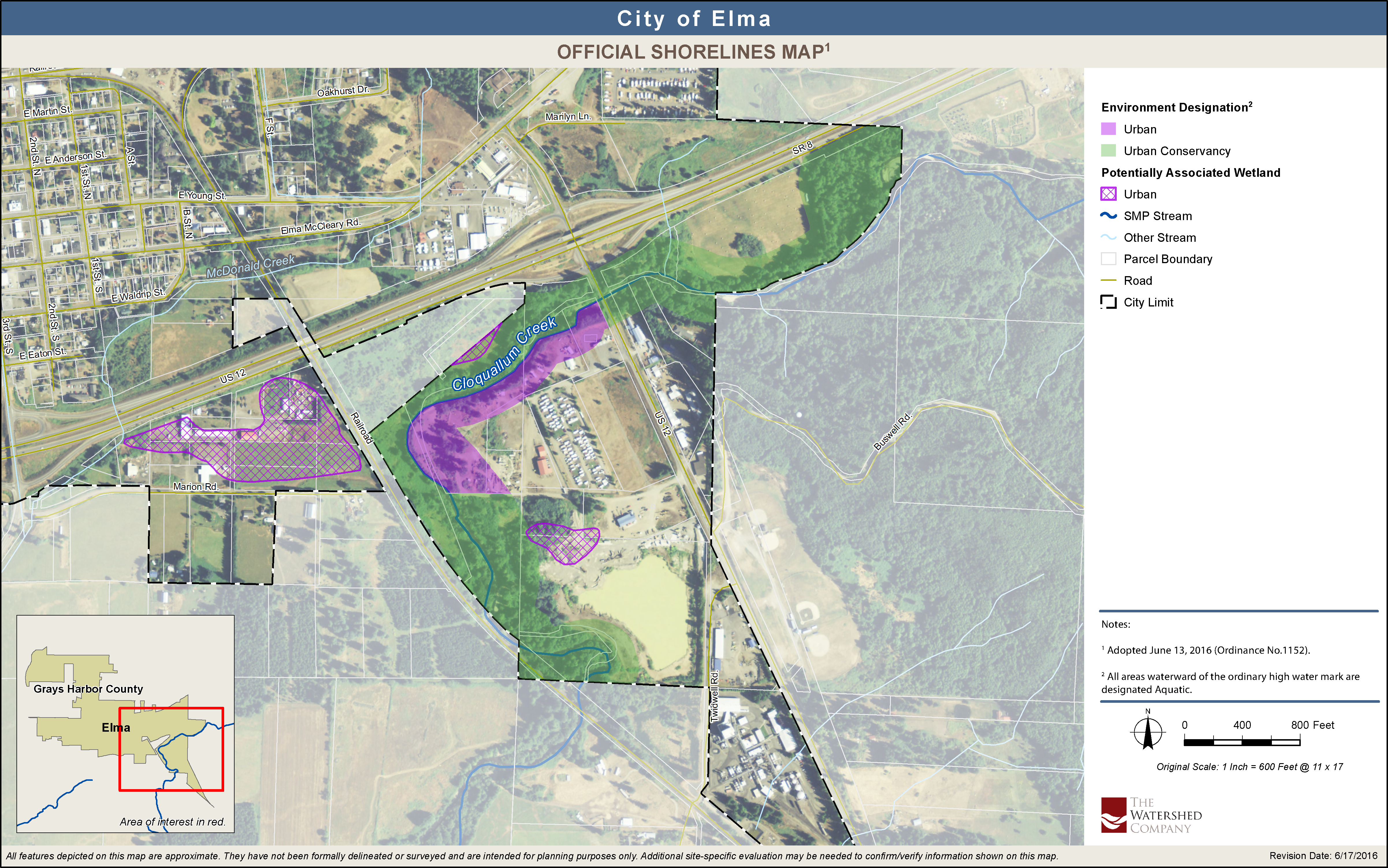
(Ord. 1152 §3 (Appx. A), 2016).