


9. TRANSPORTATION MEASUREMENT
Goal T-8: Measure and report on progress toward achieving goals and completing actions.
Background
For several years Kirkland’s Transportation Commission and City Council have contemplated a revised concurrency system that eliminates some of the deficiencies of the existing system. The new system is multimodal and meets the interest of many stakeholders: be easier to understand.
“Level of service” is a term for the performance of the transportation system. One of the required parts of the Transportation Element of the Comprehensive Plan is a level of service for each mode. The underlying philosophy for Kirkland’s level of service is that an acceptable level of service is, by definition, the level of service resulting from the completed 20-year transportation network and the fulfillment of the Land Use Plan. The reason for this is that the projects selected for the transportation network are derived from the goals and policies of the plan including financial constraints, and were chosen because of the performance they provide as a group given the number of trips forecast for the future. (See 20-Year Transportation Project List.)
Mode split refers to the fraction of trips using various modes: auto, bike, walking and transit. Mode split percentages for the Totem Lake Urban Center are required to be adopted.
Successful implementation of Kirkland’s transportation goals and policies is aided by a clear plan of action. This should take the form of a distillation of the actions of the Transportation Master Plan over the short term presented in a way that is easy to understand and accessible for a wide range of stakeholders. In addition to those actions, other information about the transportation system should be summarized in a way that is meaningful and so that progress toward a handful of measures is simple to track over time. This could include crash rates, delay at intersections, length of school walk routes without sidewalks and the levels of completion identified in Policy T-8.2. Progress toward the goals of this plan should be reported annually to the City Council and Transportation Commission. An example is provided below.
|
Why Change Concurrency? |
|
|
The new system better fits the multimodal nature of Kirkland’s transportation plan and removes complications from the system. |
|
|
Current system: |
|
|
• |
Focuses on Signalized Intersections; only projects at these intersections provide capacity that counts toward concurrency. |
|
• |
Complicated calculations. |
|
• |
Hard to understand the number of trips left in the system. |
|
New system: |
|
|
• |
Multimodal; all kinds of projects are considered to provide mobility. |
|
• |
Once the system is set up, it is fairly easy to implement and monitor. Results can be interpreted by all participants. |
|
Concurrency is implemented through an ordinance that is approved by the City Council. |
|
|
How much is too much? |
|
|
Concurrency measures the number of trips that are added from new growth and compares that to the fraction of the transportation network that is completed. New growth “uses” trips and new projects “supply” trips in the form of capacity. Particular projects supply capacity in proportion to their cost as a fraction of the 20-year network plan. |
|
Policy T-8.1: Use a multimodal plan based concurrency method to monitor the rate at which land use development and the transportation system are constructed.
The main function of concurrency is to make sure that the impacts of land use growth are balanced with transportation projects and programs. If growth is far out-pacing the rate at which transportation improvements are constructed, then permits for new developments can by halted. Such a moratorium represents a failure of the system. Ideally concurrency is managed so that development continues.
Concurrency should be no more complicated than is necessary and should consider transit, bicycling and walking along with auto travel. Concurrency should principally monitor the approved land use and transportation plans to ensure that they are being completed in relative balance. It should help achieve land use and transportation goals, rather than being an impediment to achieving those goals. 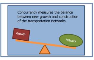
As shown above, concurrency is designed to monitor the relationship of new growth and the construction of the transportation network. For this to work properly, the future land use and future network have to be accepted before concurrency is put into place. Concurrency is not designed to determine good growth from bad growth or to determine the projects that are needed to mitigate a specific development.
Policy T-8.2: Establish an acceptable level of service for all modes.
Under Washington’s Growth Management Act, Level of Service is a requirement of transportation elements in each city’s Comprehensive Plan. Level of service serves as a useful evaluation tool. For example, it can be used as a prioritization factor for transportation projects.
Level of service standards for each mode primarily address completeness of various aspects of the transportation network, in order to complement the concurrency system and to directly measure an aspect for which the City has control. This TMP uses the term “level of completion” in place of “level of service” when referring to the actual measure. Because the Growth Management Act requires agencies to use the term Level of Service, that’s the term used for the overall approach.
|
Reporting on Level of Completion |
|
Level of completion standard has 3 possible values: |
|
• Behind schedule – completion is 90% or less of target |
|
• On schedule – completion is between 90% and 110% of target |
|
• Ahead of schedule – completion is more than 110% of target |
|
Example after five years (level of completion is reported annually): |
|
After 5 years (25% of 20 years) the fraction of completion of each area is compared to 25% and a value is determined. |
|
|
In general, the level of completion is an outcome of choices made based on available funding and on the goals and polices of the Transportation Element. This is in contrast to being chosen as an objective performance measure. For example a set of auto projects could have been developed around a relatively low level of delay. This would be a very expensive set of projects that would have resulted in the types of road widening that is not in keeping with the adopted vision for transportation. Rather than using performance as an input, it is an outcome. Considering level of service as an outcome rather than an input is consistent with the manner in which it has been treated by the City of Kirkland since the early 1990s.
The level of completion choices made for each mode are aligned with the proposed 20-year network project list as shown in the table below.
Time is the basis for evaluating the level of completion. Level of completion measures the rate of project completion over the course of the 20-year period. For example, after five years (one quarter or 25 percent of the 20-year period), the target is for at least one quarter or 25 percent of each type of project to be completed. Level of completion is to be reported annually.
Cities are required by RCW 36.70A.070(6)(a)(iii)(C) to reference the LOS standards for all state routes in the transportation element of their local comprehensive plans. The purposes of reflecting level of service standards for state highways in the local comprehensive plan are to monitor the performance of the system, to evaluate improvement strategies, and to facilitate coordination between the county’s or City’s six-year street, road, or transit program and the Office of Financial Management’s 10-year investment program. The only state route in Kirkland is I-405, which is a highway of statewide significance. The Washington State Department of Transportation has established a level of service “D” as defined by the Highway Capacity Manual for I-405.
|
Level of Completion Area |
What is to be completed with the 20-year plan |
|---|---|
|
Maintain: Pavement condition |
All collector and arterial streets have new surface. |
|
Walk: School Walk Routes |
Sidewalk on one side of school walk routes on collector and arterial streets. |
|
Walk: 10 minute neighborhoods |
Sidewalk on one side of collector and arterial streets in highest scoring 10 minute neighborhood routes. |
|
Walk: Crosswalks |
Upgrade 85 crosswalks on arterials that have limited improvements and 71 crosswalks with poor lighting. |
|
Bike: On-street bike lanes |
Improve the bike system to better than 5’ wide unbuffered lanes. |
|
Bike: Greenway network |
Complete the greenway network1 |
|
Transit: Passenger environment |
Improve lighting, shelters, etc. at 30 highest ridership locations. |
|
Transit: Speed and reliability |
Transit signal priority at 45 intersections2 on high priority transit routes. |
|
Auto: ITS |
Improvements to ITS system3 including connecting signals, parking technology, advance control methods and improved traveler information. |
|
Auto: projects |
Completion of roadway projects that support plan goals such as NE 132nd Street intersection and street projects 100th Avenue design and construction I-405 Interchange design/development Juanita Drive Auto improvements |
1 Excludes two bridges over I-405
2 Placeholder improvements pending completion of transit plan
3 Improvements beyond work currently funded
Policy T-8.3: Adopt mode split goals for the Totem Lake and Greater Downtown Urban Centers.
“Mode split” is the term used to describe how trips are allocated amongst various types of transportation, or modes. The illustration below shows mode split based on a region wide survey by the Puget Sound Regional Council.![]()
Source: Puget Sound Regional Council
Mode Split Goals are required to be adopted for Urban Centers. A baseline estimate of mode split for the Totem Lake Urban Center is 19 percent non-drive alone. This estimate is based on 2010 data from the Puget Sound Regional Council as shown in the table below.
|
Mode |
Fraction of Trips |
|---|---|
|
Drive Alone |
81% |
|
HOV 2+, vanpool, Transit |
16% |
|
Walk and Bike |
3% |
A baseline estimate of mode split for the Central Business District (CBD) is shown in the table below. Current mode split in the CBD is low because it does not currently include any major CTR employers. In contrast, large CTR employers just outside the CBD and within the Greater Downtown Urban Center are currently achieving mode splits with between 62% and 78% drive-alone.
|
Mode |
Fraction of Trips |
|---|---|
|
Drive Alone |
88% |
|
Transit |
1% |
|
Rideshare |
5% |
|
Walk and Bike |
6% |
The future goals for the Totem Lake and Greater Downtown Urban Centers are shown below:
|
Mode |
Fraction of Trips |
|---|---|
|
Drive Alone |
45% |
|
HOV 2+, vanpool, Transit |
46% |
|
Walk and Bike |
9% |
The goals were derived from the Bellevue-Kirkland-Redmond (BKR) transportation model, but the BKR model does not fully recognize the reduction in vehicle trips that occur in and around mixed-use developments, such as Downtown Kirkland today and what is envisioned for the Totem Lake neighborhood. To better reflect the kind of travel that would occur in a more walkable, mixed-use environment, an innovative trip generation method recognizes the relationship between travel and the built environment. This method supplements the BKR model by recognizing how built environment variables (known as the Ds) including density, diversity of land uses, destinations (accessibility), development scale, pedestrian and bicycle facility design, distance to transit services, and demographics affect travel. In short, places with higher densities, a rich variety of land uses close to one another, and high quality pedestrian, bicycle, and transit environments have lower vehicle trip generation rates. People have more choices in terms of both the travel mode as well as how far they must travel to reach various destinations.
These mode split targets should be coordinated with the City’s Transportation Demand Management Program. (See Policy T-3.4.)
Policy T-8.4: Ensure implementation of the Goals and Policies in the Transportation Element and monitor progress toward those goals.
An Action Plan should include enough information so that people who are not familiar with the Transportation Master Plan can readily understand the key points of the Plan and the actions necessary to accomplish its goals. The Action Plan should include a time component for completing each action. It may also be helpful to set objectives that further break down each action.
A “transportation report card” with a relatively few select measures, including a safety section, that address the key elements of the TMP, presented in a manner that is easily understood by the public, should be developed. These measures should be coordinated with the Action Plan, tracked by the Transportation Commission and City Council and be widely distributed. Reports should be timed to help inform decisions needed to prepare the transportation Capital Improvement Plan.
(For related information, see the Implementation Strategies Chapter of the Comprehensive Plan.)