


Chapter 22.400
GENERAL REGULATIONS
Sections:
22.400.100 Existing development.
22.400.105 Proposed development.
22.400.120 Vegetation conservation buffers.
22.400.125 Water quality and quantity.
22.400.130 Historic, archaeological, cultural, scientific and educational resources.
22.400.140 Bulk and dimension standards.
22.400.150 Flood hazard reduction measures.
22.400.155 Restoration and enhancement.
22.400.100 Existing development.
A. Existing Uses.
1. Lawfully established uses occurring as of the effective date of this program shall be considered conforming to this program, with the exception of existing over-water residences and existing non-water-oriented commercial or industrial uses, which shall be considered nonconforming.
2. All lawfully established uses, both conforming and nonconforming, may continue and may be repaired, maintained, expanded or modified consistent with the Act and this program.
3. Any change in use shall conform to the standards of this program and may require a conditional use permit (CUP) in accordance with Section 22.500.100(D). A CUP may be granted only if no reasonable alternative use meeting the standards is practical, and the proposed use will be at least as consistent with the policies and provisions of this program and the Act and as the uses in the area as the preexisting use. Conditions may be imposed that are necessary to assure compliance with the above findings and with the requirements of this program and the Act, to assure that the use will not become a nuisance or a hazard, and to assure that the use will not result in a net loss of the ecological function of the shoreline.
4. If a use is discontinued for twelve consecutive months or for twelve months during any two-year period, any subsequent use, if allowed, shall comply with the Act and this program.
B. Existing Structures.
1. Lawfully Constructed Structures.
a. Lawfully constructed structures, including those approved through a variance, built before the effective date of this program shall be considered conforming, with the exception of existing over-water residences, which shall be considered nonconforming.
b. All lawfully constructed structures may continue and may be repaired or maintained in accordance with the Act and this program.
c. Lawfully constructed conforming structures may be expanded or redeveloped in accordance with the mitigation standards of Chapter 22.800, Appendix B (Mitigation Options to Achieve No Net Loss for New or Re-Development Activities), and all other applicable regulations. Such expanded or redeveloped structures shall be considered conforming.
d. In the event that a legally existing structure is damaged or destroyed by fire, explosion or other casualty, it may be reconstructed to configurations existing immediately prior to the time the structure was damaged or destroyed, provided a complete application submittal is made for the necessary permits within twelve months of the date the damage or destruction occurred, and the restoration is completed within two years of permit issuance or the conclusion of any appeal on the permit.
e. Any legally existing structure that is moved any distance must be brought into conformance with the Act and this program.
2. Existing Appurtenances to Single-Family Residences. Those legally existing appurtenances that are common to existing single-family residences shall be considered conforming to this program. Such appurtenances may include garages and sheds, but shall not include bulkheads, over-water structures or other shoreline modifications.
3. Vegetation conservation standards of this program shall not apply retroactively in a way which requires lawfully existing uses and developments, including residential landscaping and gardens, to be removed, except as required as mitigation for new and expanded development.
4. Structures, improvements, docks, fills or developments lawfully placed in or over navigable waters prior to December 4, 1969, shall be considered nonconforming, but may continue in accordance with RCW 90.58.270.
C. Existing Lots.
1. An undeveloped lot, tract, parcel, site, or division of land located landward of the OHWM that was created or established in accordance with local and state subdivision requirements prior to the effective date of this program or the Act, but which does not conform to the present lot size standards, may be developed if permitted by other land use regulations so long as such development conforms to all other requirements of this program or the Act.
2. This section does not modify the rules regarding the development of plats under RCW 58.17.170 as now or hereafter amended.
(Ord. 598 (2021) § 4 (Appx. 1), 2021)
22.400.105 Proposed development.
A. Location.
1. New development shall be located and designed to avoid or, if that is not possible, to minimize the need for new and maintenance dredging.
2. New development shall be located and designed to avoid the need for future shoreline stabilization for the life of the structure. Likewise, any new development which would require shoreline stabilization which causes significant impacts to adjacent or down-current properties shall not be allowed.
3. New development on lots constrained by depth, topography or critical areas shall be located to minimize, to the extent feasible, the need for shoreline stabilization.
4. New development on steep slopes or bluffs shall be set back sufficiently to ensure that shoreline stabilization is unlikely to be necessary during the life of the structure, as demonstrated by a geotechnical analysis.
5. Subdivision shall be planned to avoid the need for shoreline stabilization for newly created lots, utilizing geotechnical analysis where applicable.
6. Non-water-oriented facilities and accessory structures, except for preferred shoreline uses, such as single-family residences and single-family residential appurtenances when consistent with buffer provisions in this chapter, must be located landward of buffers and adjacent water-oriented uses, or outside shoreline jurisdiction, unless no other location is feasible.
B. Standards for Work Waterward of OHWM.
1. Water-dependent in-water structures, activities, and uses are not subject to the shoreline buffers established in this program.
2. Projects involving in-water work must obtain all applicable state and federal permits or approvals, including those from the U.S. Army Corps of Engineers, Ecology, Washington Department of Fish and Wildlife (WDFW), and/or Washington Department of Natural Resources.
3. Projects involving in-water work must comply with timing restrictions as set forth by state and federal project approvals.
4. Protection of Bank and Vegetation.
a. Alteration or disturbance of the bank and bank vegetation must be limited to that necessary to perform the in-water work.
b. All disturbed areas must be restored and protected from erosion using vegetation or other means.
5. If, at any time, water quality problems develop as a result of in-water work, immediate notification must be made to any appropriate state or federal agency, e.g., Ecology, WDFW, National Marine Fisheries Service, U.S. Fish and Wildlife Service, etc. Affected tribes shall also be notified.
(Ord. 598 (2021) § 4 (Appx. 1), 2021)
22.400.110 Mitigation.
A. Mitigation Sequencing.
1. Permitted uses and developments shall be designed and conducted in a manner that protects the current ecological condition, and prevents or mitigates adverse impacts. Mitigation measures shall be applied in the following sequence of steps, listed in order of priority:
a. Avoid the impact altogether by not taking a certain action or parts of an action;
b. Minimize impacts by limiting the degree or magnitude of the action and its implementation by using appropriate technology or by taking affirmative steps to avoid or reduce impacts;
c. Rectify the impact by repairing, rehabilitating or restoring the affected environment;
d. Reduce or eliminate the impact over time by preservation and maintenance operations;
e. Compensate for the impact by replacing, enhancing, or providing substitute resources or environments, including utilization of the in-lieu fee process where appropriate; and
f. Monitor the impact and the mitigation projects, and take appropriate corrective measures.
2. Application of the mitigation sequence shall achieve no net loss of ecological functions for each new development and shall not result in required mitigation in excess of that necessary to assure that development will result in no net loss of shoreline ecological functions and not have a significant adverse impact on other functions fostered by the policy of the Act or this program.
B. Mitigation Options.
1. After mitigation sequencing is applied in accordance with subsection (A) of this section, Chapter 22.800, Appendix B, Mitigation Options to Achieve No Net Loss for New or Re-Development Activities, shall be utilized for compensatory mitigation options.
2. Site selection for compensatory mitigation shall consider factors to determine the most ecologically suitable potential mitigation site. References for consideration when determining appropriate site selection may include the Hood Canal Coordinating Council In-Lieu Fee Program Instrument, Appendix H, Watershed Approach to Mitigation, or other current resources informing mitigation decisions.
3. Proposals that use ratios different from those prescribed in this program, that seek to obtain alternative buffers (Section 22.400.120(C)), or that include larger modifications in a buffer (Section 22.400.120(D)) may be approved if justified in a shoreline mitigation plan consistent with Section 22.700.140 when prepared by a qualified professional as defined in Section 22.150.505(B). Where applicable, a shoreline variance may be required in accordance with Section 22.500.100(E).
4. Activities not listed in Chapter 22.800, Appendix B, that result in adverse impacts to shoreline ecological functions shall also be subject to compensatory mitigation requirements.
5. When compensatory mitigation becomes necessary on a site where documented restoration activities have occurred within the previous five years, but after the effective date of this program, such documented restoration may be utilized as mitigation to offset new development impacts, provided the restoration was voluntary and not required as mitigation for prior development impacts. Mitigation credit for prior restoration activities shall be determined upon application for the impacting project, and shall, at a minimum, be commensurate with the proposed level of impact unless additional compensatory mitigation is provided.
C. Mitigation Compliance.
1. Unless otherwise specified, mitigation shall take place prior to final project inspection to provide assurance that it will be completed and to mitigate for temporal loss of shoreline functions.
2. Kitsap County shall require monitoring reports on an annual basis for a minimum of five years and up to ten years, or until mitigation success is demonstrated through at least two consecutive monitoring reports. The mitigation plan shall provide specific criteria for monitoring the mitigation project. Results and additional conditions shall be electronically tagged to the parcel for future reference.
3. Mitigation requirements shall run with the parcel, and notice of such requirements shall be recorded as a notice to title. Mitigation as conditioned under project approval shall be maintained in perpetuity, except where authorized through review of an alternative mitigation plan.
4. In the event that a subsequent landowner applies for additional permits, the electronic permit database will be queried for past mitigation requirements. If such mitigation is no longer in place or functioning, it shall be reinstalled prior to permit issuance.
5. Mitigation enforcement shall occur under the authority of Chapter 22.500, Permit Provisions, Review and Enforcement.
(Ord. 598 (2021) § 4 (Appx. 1), 2021)
22.400.115 Critical areas.
A. Incorporation of Title 19. The following sections of Title 19, Critical Areas Ordinance, adopted June 28, 2021, are incorporated herein by this reference, and provided in Chapter 22.800, Appendix E, for reference purposes only, except as supplemented or modified under subsections (B) through (F) of this section:
1. Standards for existing development (Section 19.100.130*), as applicable and consistent with Chapter 22.500.
2. General application requirements (Section 19.100.155*).
3. Inventory provisions (Section 19.100.160*).
4. Critical aquifer recharge areas (Chapter 19.600*).
5. Fish and wildlife habitat conservation areas (Chapter 19.300*).
6. Frequently flooded areas (Chapter 19.500*).
7. Geologically hazardous areas (Chapter 19.400*).
8. Wetlands (Chapter 19.200*).
9. Definitions (Chapter 19.150*), except where conflict exists, then the definitions in this program shall govern.
* Editor’s Note: Hyperlinks are to a PDF of the June 28, 2021, CAO and not to current code provisions.
B. Frequently Flooded Areas. Before new development activities are permitted within the floodplain, compliance with Federal Emergency Management Agency (FEMA) National Flood Insurance Program (NFIP) protection standards for critical habitats for listed species shall be demonstrated through submittal of a habitat management plan prepared by a qualified wildlife biologist.
Also see Section 22.400.150 (Flood hazard reduction measures) for additional regulations governing uses and modifications in floodways, floodplains and channel migration zones.
C. Critical Freshwater Habitats. Critical freshwater habitats include those portions of streams, rivers, wetlands, lakes and their associated channel migration zones and floodplains that provide habitat for priority species at any stage in their life cycles, and provide critical ecosystem-wide processes, as established in WAC 173-26-221(2)(c)(iv). Specific standards follow.
1. Lakes Twenty Acres or Greater.
a. Vegetation buffers shall be retained for each shoreline environment designation as specified in Section 22.400.120 (Vegetation conservation buffers).
b. Where a lot cannot accommodate required buffers due to size, shape or topography, the alternatives for new development (Section 22.400.120(C)(1)) and alternatives for existing development (Section 22.400.120(C)(2)) shall apply.
c. The specific shoreline use and modification development standards of the program shall apply (Chapter 22.600).
2. Streams and Rivers over Twenty cfs Mean Annual Flow.
a. A two-hundred-foot vegetation buffer and an additional fifteen-foot building setback shall be maintained from the OHWM. Additional critical area setbacks may apply where flood hazard areas, geologically hazardous areas, or wetlands are present.
b. Where a lot cannot accommodate required buffers due to size, shape or topography, the alternatives for new development (Section 22.400.120(C)(1)) and alternatives for existing development (Section 22.400.120(C)(2)) shall apply.
c. The specific shoreline use and modification development standards of the program shall apply (Chapter 22.600).
3. The subdivision of land shall not be established when it would be reasonably foreseeable that the development or use would require structural flood hazard reduction measures within the channel migration zone or floodway. When evaluating alternate flood control measures or floodplain restoration opportunities, the removal or relocation of structures in flood-prone areas shall be given consideration.
D. Critical Saltwater Habitats.
1. Critical saltwater habitats require a higher level of protection due to the important ecological functions they provide. Nonresidential docks, bulkheads, bridges, fill, floats, jetties, utility crossings and other human-made structures shall not intrude into or over critical saltwater habitats except in the following circumstances, and only when the applicable use or modification standards are also met (Chapter 22.600).
a. The public’s need for such an action or structure is clearly demonstrated, and the proposal is consistent with protection of the public trust.
b. Avoidance of impacts to critical saltwater habitats by an alternative alignment or location is not feasible or would result in unreasonable and disproportionate cost to accomplish the same general purpose. A cost analysis may be required to assist with the feasibility determination.
c. The project, along with any required mitigation, will result in no net loss of ecological functions associated with critical saltwater habitat.
d. The project is consistent with the state’s interest in resource protection and species recovery.
2. When a habitat survey (see Section 22.700.145, Biological and habitat surveys) is required pursuant to the applicable use or modification section, the Kitsap County Shoreline Inventory and Characterization Report shall be consulted as a basis for existing conditions, along with appropriate field verification. See the applicable sections for specific measures necessary for minimization and mitigation of impacts to critical saltwater habitats.
3. Critical saltwater habitats include (see Chapter 22.150, Definitions, for more detail):
a. Kelp beds.
b. Eelgrass beds.
c. Spawning and holding areas for forage fish, such as herring, smelt and sand lance.
d. Shellfish beds (subsistence, commercial and recreational).
e. Mudflats.
f. Intertidal habitats with vascular plants.
g. Areas with which priority species have a primary association.
E. Geologically Hazardous Areas. Channel migration zones shall be classified as landslide hazard areas, and may be either high geologic hazard or low geologic hazard depending on the site characteristics outlined in Section 19.400.410(A). Channel migration zone maps can be found in Appendix D to the ordinance codified in this title.
F. Wetlands.
1. Exemptions for small wetlands in Section 19.200.210(C) shall not apply.
2. A wetland buffer may not be reduced through averaging more than twenty-five percent of the standard buffer width applied per Section 19.200.220(B)(1). The fifty percent averaging reduction allowed in Section 19.200.220(B)(1)(e) shall not apply.
3. Administrative buffer reductions in Sections 19.200.220(B)(2)(a) through (d) shall not apply.
4. Additional development standards for certain uses in Sections 19.200.225(C) and (G) shall not apply.
(Ord. 598 (2021) § 4 (Appx. 1), 2021)
22.400.120 Vegetation conservation buffers.
A. General Regulations.
1. Vegetation conservation buffers provide a means to conserve, protect and restore shoreline vegetation in order to provide for ecological and habitat functions as well as human health and safety. Buffers shall consist of a non-clearing area established to protect the integrity, functions and values of the affected critical area or shoreline, but may also be modified and reduced to accommodate allowed uses when consistent with the Act and this program. The standards below provide a flexible approach to maximize both ecological functions and water-dependent uses.
2. Vegetation conservation standards shall not be applied retroactively in a way which requires lawfully existing uses and developments (as of the effective date of this program), including residential landscaping and gardens, to be removed, except when required as mitigation for new or expanded development.
3. In order to implement this program’s policies for preservation of native plant communities on marine, river, lake and wetland shorelines, mitigation sequencing shall be applied during site planning for uses and activities within the shoreline jurisdiction so that the design and location of the structure or development minimizes native vegetation removal. Development or uses that require vegetation clearing shall be designed to avoid the following in the order indicated below, with subsection (A)(3)(a) of this section being the most desirable vegetation to retain:
a. Native trees;
b. Other native vegetation;
c. Nonnative trees; and
d. Other nonnative vegetation.
B. Buffer Widths.
1. Standard Buffer. Each shoreline environment designation shall have a starting, or standard, buffer as measured landward from the OHWM. This buffer shall be adhered to unless otherwise allowed as described in the reduced standard buffer provisions below. The standard buffers for each environment designation are as follows:
a. High intensity: fifty feet.
b. Shoreline residential: eighty-five feet.
c. Urban conservancy: one hundred feet.
d. Rural conservancy: one hundred thirty feet.
e. Natural: two hundred feet.
f. The standard buffer for shoreline jurisdictional freshwater streams and rivers is two hundred feet.
2. Reduced Standard Buffer. Utilizing the “mitigation options to achieve no net loss for new or redevelopment activities” table (Chapter 22.800, Appendix B) to achieve no net loss of shoreline ecological functions, the standard buffer may be reduced down to a reduced standard buffer as specified below. Mitigation options shall be reviewed and approved by the county for applicability to the project site commensurate with project impacts. The shoreline restoration plan (Appendix C) shall serve as an initial review source.
An applicant shall have the burden of proving they have complied with Sections 22.400.110(A), Mitigation Sequencing, and 22.500.100(E), Variances and Administrative Variances. This may be documented within a shoreline mitigation plan. Buffer reductions shall provide adequate documentation demonstrating need. The department shall deny a buffer reduction request if the applicant either created or exacerbated the condition that forms the limitation on the use and development of the property. The reduced standard buffers for each environment designation are as follows: The reduced standard buffers for each environment designation are as follows:
a. High intensity: fifty feet.
b. Shoreline residential: fifty feet.
c. Urban conservancy: eighty-five feet; fifty feet where a net gain in shoreline ecological functions can be achieved. Applications for reductions below eighty-five feet shall include information documenting: (i) mitigation necessary to achieve no net loss of shoreline ecological functions for the reduced eighty-five-foot buffer; (ii) additional mitigation necessary to achieve no net loss for any reduction below eighty-five feet; and (iii) additional actions proposed to achieve a net gain in shoreline ecological functions. Proposed restoration activities shall not include projects previously identified for public funding, except that public-private partnerships may be utilized. A minimum five-year monitoring plan shall be required to demonstrate project success, in accordance with Section 22.400.110(C), Mitigation Compliance.
d. Rural conservancy: one hundred feet.
e. Natural: one hundred fifty feet.
f. Shoreline jurisdictional freshwater streams and rivers: two hundred feet; buffers may be reduced pursuant to the standards in subsection (C) of this section.
3. Additional Standards for Applying the Reduced Standard Buffer Within the Rural Conservancy and Natural Designations and Shorelines of Statewide Significance. Buffers may be reduced for single-family residences and water-oriented uses in the rural conservancy designation, natural designation, and shorelines on Hood Canal only under the following circumstances:
a. The lot is physically constrained by slopes, wetlands or other natural features such that the standard buffer cannot be met;
b. The lot is legally constrained by its size or shape, such that it would not support a home and garage with a footprint of at least one thousand two hundred square feet if placed at or above the standard buffer; or
c. The existing condition is such that the lot was previously cleared below the standard buffer, and intact, mature native vegetation is located at or above the standard buffer which would otherwise be removed in order to comply with the standard buffer.
4. An additional fifteen-foot building setback shall be maintained beyond the outer boundary of the buffer. This building setback may be reduced; provided, that the resulting setback is protective of existing vegetation within the buffer.
C. Constrained Lot and Infill Provisions.
1. Alternatives for New Development. New single-family and water-dependent development may qualify for an alternative buffer if the following apply:
a. Infill Provision. For new construction on a vacant parcel adjoined by existing homes on both sides, the reduced standard buffer may be administratively reduced by up to ten percent in compliance with Section 22.400.135 (View blockage). This shall be a Type I administrative review process. The mitigation options to achieve no net loss for new or redevelopment activities table (Chapter 22.800, Appendix B) shall apply to such reductions.
b. Constrained Lot Provisions.
i. Legally Platted Lots with a Depth That Would Not Allow for Compliance with the Reduced Standard Buffer. Proposals to reduce the buffer below the reduced standard buffer shall require a shoreline mitigation plan (Section 22.700.140), starting with review of existing conditions as presented in the Kitsap County Shoreline Inventory and Characterization Report and supplemented with appropriate field verification.
ii. If the development requires less than a twenty-five percent reduction of the reduced standard buffer, or any amount of buffer reduction within the shoreline residential designation, a Type II administrative variance shall be required. If the development is not within the shoreline residential designation and requires greater than a twenty-five percent reduction of the reduced standard buffer, a Type III variance shall be required.
c. Water-Dependent Development. Buffers may be modified and reduced to accommodate water-dependent uses when consistent with the Act and this master program, and when conducted so that no net loss of critical areas or shoreline ecological functions occurs.
2. Alternatives for Existing Development.
a. Expansion of Development Outside of the Standard Buffer. Expansion of existing development outside the standard buffer shall be permitted, provided all other applicable provisions are met.
b. Expansion of Development Within the Standard Buffer. Structures in existence on the effective date of this program that do not meet the setback or buffer requirements of this program may be remodeled or reconstructed; provided, that the new construction or related activity does not exceed the standard height limit, and does not further intrude into the standard buffer except where mitigation is applied pursuant to the mitigation options to achieve no net loss for new or redevelopment activities table (Chapter 22.800, Appendix B). Mitigation may be waived where the expansion occurs directly upland of the existing structure and where such expansion does not require removal of intact native vegetation or expansion of impervious surfaces.
c. Expansion of Development Below the Reduced Standard Buffer. Expansion of existing development below the reduced standard buffer may only occur if approved through a shoreline variance pursuant to Section 22.500.100(E). To reduce the procedural burden on applicants, in some cases the variance may be approved administratively as a Type II decision according to the criteria below and the variance criteria in Section 22.500.100(E):
i. Expansion of development shall not occur further waterward of the existing structure, unless no other feasible option exists due to physical constraints of the property.
ii. Any expansion below the reduced standard buffer shall require a shoreline mitigation plan (see Section 22.700.140).
iii. Expansion within the outer twenty-five percent of the reduced standard buffer or within any portion of the buffer in the shoreline residential designation shall require a Type II administrative variance, according to the conditions of subsection (C)(2)(c)(iv) of this section. Expansion within the waterward seventy-five percent of the reduced standard buffer shall require a Type III variance.
iv. Expansion of a single-family residence below the reduced standard buffer may be allowed through Type II administrative variance for limited expansions of no more than twenty-five percent of the existing gross floor area or six hundred twenty-five square feet, whichever is less, if expanding into an existing legally cleared area and located no further waterward than the existing structure.
D. Other Uses and Modifications in Vegetation Conservation Buffers.
1. In order to accommodate water-oriented uses and modifications within the buffer, the following standards shall apply subject to shoreline permit review unless otherwise exempted:
a. Trails. Trails may be permitted but shall be limited to five feet in width, except where demonstrated necessary for a water-dependent use. Trails shall comply with requirements of Title 12 (Stormwater Drainage) if applicable. Disturbance to soil, hydrological character, trees, shrubs, snags and important wildlife habitat shall be minimized. Pervious surface materials, such as mulch, organics, raised boardwalks composed of untreated wood or an equivalent, are required. Gravel trails shall be considered impervious surfaces pursuant to Title 12. Pervious surfaces shall be utilized except where determined infeasible.
i. Trails in vegetation conservation buffers shall be located in the outer twenty-five percent of the buffer, except where necessary for direct access or viewing points.
ii. Trails that meet the definition of water-oriented use may be located within shoreline buffers when it can be demonstrated that buffer impacts are limited through mitigation sequencing in accordance with Section 22.400.110(A).
b. Decks and Viewing Platforms. Decks and viewing platforms may be permitted, but shall be limited to one hundred square feet in size, in order to provide opportunities for small viewing decks or platforms that will not result in a net loss of shoreline ecological function. Applicants shall demonstrate no net loss as part of a shoreline mitigation plan prepared by a qualified professional (Section 22.700.140). Viewing platforms shall not have roofs, except where otherwise permitted through the view blockage standards (Section 22.400.135). Creosote and pentachlorophenol should not be utilized in construction materials for decks, viewing platforms or boardwalks.
c. Beach Stairs. Beach stairs may be permitted, subject to the permitting requirements of Chapter 22.500. Beach stairs placed waterward of the OHWM will normally require a hydraulic project approval (HPA) from WDFW.
i. Stair landings in the vegetation conservation buffer or below waterward of the OHWM must be composed of grating or other materials that allows a minimum of sixty percent light to transmit through.
ii. Viewing platforms associated with beach stairs shall comply with subsection (D)(1)(b) of this section.
iii. Stair landings waterward of the OHWM must comply with the provisions of Section 22.600.160(C).
d. Trams. Trams may be permitted, subject to the permitting requirements of Chapter 22.500. Trams are not considered appurtenances under this section. They are prohibited in the aquatic and natural shoreline environment designations. The following development standards apply:
i. Tram landings may not exceed one hundred square feet each.
ii. The width of a clearing for a tram shall be a maximum of five feet on either side of the tram, with a maximum clearing corridor of fifteen feet.
iii. The installation of a tram shall be limited only to geologically hazardous areas as defined in Chapter 19.400 and subject to “special studies” as outlined in Section 22.700.120.
iv. Mitigation sequencing must be used to avoid, minimize, and compensate for any impacts; enhancement of shoreline buffer vegetation will be required. See Section 22.700.140, Shoreline mitigation plan, for guidance on minimum submittal requirements.
e. Boat Launches and Marine Railways. Boat launches and marine railways, when consistent with requirements in Section 22.600.160(C)(6), may be permitted with an exemption or SDP in the shoreline residential or high-intensity environments, or as a CUP in the rural conservancy or urban conservancy environments, provided all applicable provisions are met to avoid net loss of shoreline functions.
f. Water-Oriented Storage. Water-oriented storage, including boat houses or boat storage facilities, may be permitted within the buffer provided:
i. The width shall be no greater than twenty-five feet or twenty-five percent of the lot width, whichever is less.
ii. The height shall not be greater than fourteen feet above grade, and shall also comply with the view blockage provisions of this program.
iii. The overall size shall not exceed two hundred square feet. Exceptions may be considered upon demonstration of need. In such cases, applicable mitigation options to achieve no net loss for new or redevelopment activities (Chapter 22.800, Appendix B), view blockage (Section 22.400.135), and buildings and construction (Title 14) provisions shall apply.
iv. Allowance of a boat house within a buffer shall not justify the need for shoreline armoring to protect the structure.
v. Boat houses shall be prohibited in the natural environment designation.
vi. Boat storage facilities within the high-intensity buffer shall not be subject to subsections (D)(1)(e)(i) through (iii) of this section, when supporting a water-dependent use and where consistent with the policies for the high-intensity shoreline environment designation.
g. In no case shall non-water-dependent uses and activities be allowed below the reduced standard buffer. This includes swimming pools and sport courts or fields.
2. Hand removal or spot-spraying of invasive or noxious weeds is permitted within vegetation conservation buffers.
3. Standards for View Thinning.
a. View thinning activities shall be limited to twenty-five percent of the total buffer length in the high-intensity and shoreline residential designations, and shall retain a minimum of thirty percent of the live crown.
b. View thinning activities shall be limited to fifteen percent of the total buffer length in the urban conservancy and rural conservancy designations, and shall retain a minimum of thirty percent of the live crown.
c. No tree removal is allowed in the natural designation for view enhancement; however, limited tree limbing may be allowed upon review and approval by the department.
d. View thinning within the limited areas specified above shall generally be limited to tree limbing. Where tree removal is demonstrated to be necessary, replanting of native trees shall occur at a three-to-one ratio (planted to removed) within the buffer area.
e. Topping of trees is prohibited, except where demonstrated necessary for safety.
f. See the forest practices/timber harvest standards (Section 22.600.145) for danger tree removal requirements.
g. An advance site visit may be required by the department of community development in order to confirm the proposed thinning is consistent with this section and critical area protection standards. Site visit request applications may be obtained online or in person at Kitsap County’s permit center. The county may also utilize site photographs in lieu of a site visit where sufficient detail is available to make a determination on consistency with thinning standards.
(Ord. 598 (2021) § 4 (Appx. 1), 2021)
22.400.125 Water quality and quantity.
New development shall provide stormwater management facilities designed, constructed and maintained in accordance with the current stormwater management standards in Title 12. An SDAP shall also be required for impervious surface creation in areas of the shoreline mapped as critical drainage areas and those meeting minimum critical drainage area criteria, defined in Title 12.
A. For sites within the census-defined urban areas, or the UGAs, the creation or cumulative addition of five thousand square feet or greater of impervious surface area from predevelopment conditions is considered major development and requires stormwater mitigation through a site development activity permit (SDAP).
B. For sites outside of the census-defined urban areas, or the UGAs, the creation or cumulative addition of impervious surfaces that results in five percent or more of the development site being covered in impervious surfaces or the creation or cumulative addition of ten thousand square feet of impervious surfaces from the predevelopment conditions, whichever is greater, is a major development, and requires stormwater mitigation through an SDAP.
C. An SDAP shall also be required for impervious surface creation in critical drainage areas, as defined in Title 12.
(Ord. 598 (2021) § 4 (Appx. 1), 2021)
22.400.130 Historic, archaeological, cultural, scientific and educational resources.
A. Applicability and Other Regulations.
1. This section applies to archaeological and historic resources either recorded by the Department of Archaeology and Historic Preservation, local jurisdictions or applicable tribal databases or predictive models.
2. HASCE sites shall comply with Kitsap County Contract KC 442-07 (Agreement with Department of Archaeology and Historic Preservation), Chapter 25-48 WAC (Archaeological Excavation and Removal Permit), Chapter 27.44 RCW (Indian Graves and Records), and Chapter 27.53 RCW (Archaeological Sites and Resources).
B. Known or Potential HASCE Sites.
1. Tribal historic preservation officers (THPOs) for tribes with jurisdiction will be provided the opportunity to review and comment on all development proposals in the Kitsap County shoreline jurisdiction, both terrestrial and aquatic, in order to ensure all known or potential archaeological sites, traditional cultural properties and traditional cultural landscapes are acknowledged, properly surveyed and adequately protected.
2. If archaeological resources are known in advance, developers and property owners must notify Kitsap County, the Department of Archaeology and Historic Preservation, and applicable tribes.
3. Sites with known or potential archaeological resources, as determined pursuant to the resources listed at the beginning of this section, shall require a site inspection by a professional archaeologist in coordination with the affected tribe(s). The THPO shall be provided the opportunity to evaluate and comment on cultural resources evaluations conducted by the professional archaeologist.
4. Work on sites with identified archaeological resources shall not start until authorized by the Department of Archaeology and Historic Preservation through an archaeological excavation and removal permit, which may condition development permits pursuant to KC 442-07.
C. Discovered HASCE Sites.
1. If archaeological resources are uncovered during excavation, developers and property owners must immediately stop work and notify Kitsap County, the Office of Archaeology and Historic Preservation and affected Indian tribes.
2. Uncovered sites shall require a site inspection by a professional archaeologist in coordination with the affected tribe(s). Tribal historic preservation officers shall be provided the opportunity to evaluate and comment on cultural resources evaluations conducted by the professional archaeologist.
3. Work shall not recommence until authorized by the Office of Archaeology and Historic Preservation through an archaeological excavation and removal permit, which may condition development permits pursuant to KC 442-07.
(Ord. 598 (2021) § 4 (Appx. 1), 2021)
22.400.135 View blockage.
A. In order to protect water views, all principal buildings, and all additions to a principal building, shall be located to maintain the minimum shoreline structure setback line. All such buildings must also be designed not to significantly impact views from principal buildings on adjoining and neighboring property or properties including reconstruction of existing principal buildings allowed per Section 22.400.100(B). The shoreline structure setback line for the purpose of this subsection is based on the location of the principal building(s) at the time of a permit for a new principal building, and shall be determined as follows:
1. No Adjacent Principal Buildings. Where there are no adjacent principal buildings, the shoreline structure setback line shall be the vegetation conservation buffer and setback specified in Section 22.400.120. See Figure 22.400.135(A)(1).
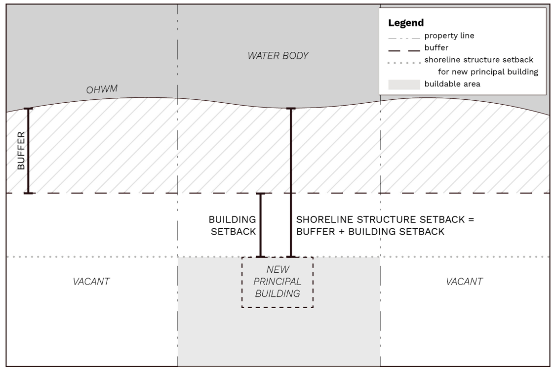
Figure 22.400.135(A)(1)
Buffer and shoreline structure setback with no adjacent structure.
2. Adjacent Principal Building on One Side. Where there is an adjacent principal building on one side, the shoreline structure setback line shall be a distance no less than that of the adjacent principal building to the shoreline or the buffer and setback specified elsewhere in this program, whichever is greater. See Figures 22.400.135(A)(2)(a) and 22.400.135(A)(2)(b).
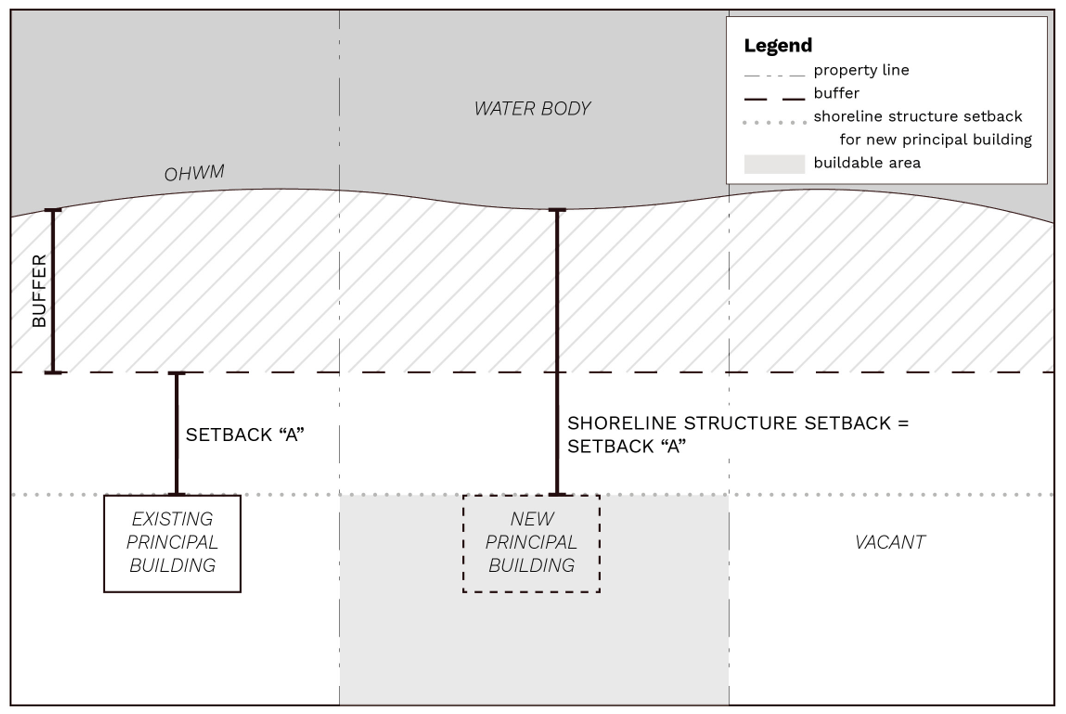
Figure 22.400.135(A)(2)(a)
Buffer and shoreline structure setback with adjacent structure landward of buffer on one side.
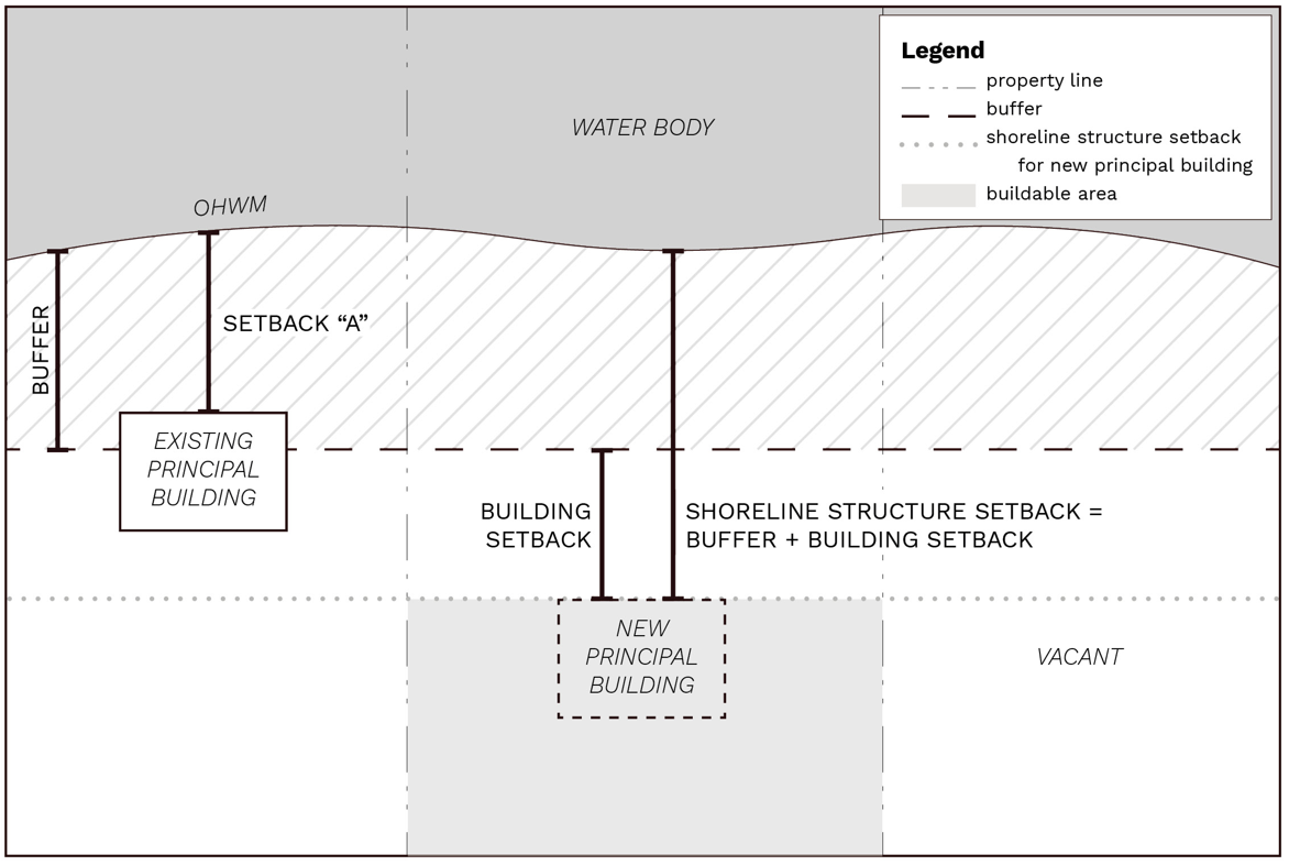
Figure 22.400.135(A)(2)(b)
Buffer and shoreline structure setback with adjacent primary structure within buffer on one side.
3. Adjacent Principal Buildings on Both Sides on a Linear Shoreline. Where there are adjacent principal buildings on both sides of the proposed structure on a linear shoreline (not along a peninsula or cove), the shoreline structure setback line shall be determined by a stringline setback or the buffer and setback specified elsewhere in this program, whichever is greater. A “stringline setback” means a straight line drawn between the points on the primary structures having the greatest projection waterward. If one of the adjacent properties is developed landward of the vegetation conservation buffer and setback, the line shall not be drawn to that adjacent structure but be drawn to the point where the standard buffer meets the side property line of the lot to be improved. See Figure 22.400.135(A)(3).
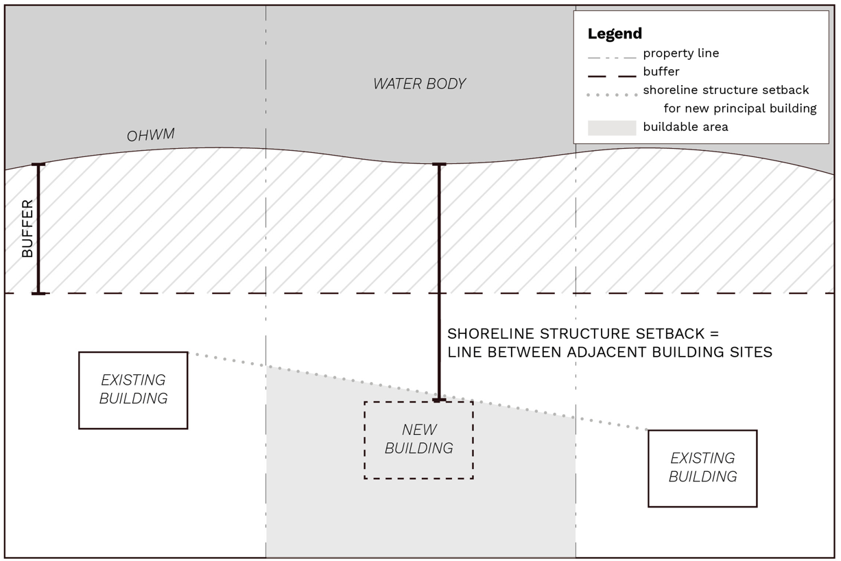
Figure 22.400.135(A)(3)
Buffer and shoreline structure setback on a regular shoreline with adjacent primary structures on both sides.
4. Where there are two adjacent principal structures on a shoreline which forms a cove, peninsula, or irregular shoreline, the shoreline structure setback line shall be determined by averaging the existing setback lines of the two adjacent principal buildings or the buffer and setback specified elsewhere in this program, whichever is greater. See Figure 22.400.135(A)(4).
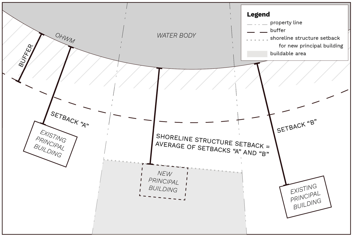
Figure 22.400.135(A)(4)
Buffer and shoreline structure setback on a irregular shoreline with adjacent primary structures on both sides.
5. Consideration of Existing Mitigating Circumstances. The shoreline structure setback line may not be applied to limit distance from the shoreline where an elevation survey prepared by a qualified professional demonstrates that existing topography or vegetation already significantly blocks views on or adjacent to the common border of the two parcels, and the proposed principal building will not result in additional view blockage to an existing adjacent principal building(s). In such cases, the buffer and setback specified elsewhere in this program shall apply.
6. Setback Line for Additions, Remodels or Rebuilds. Where there will be additions or rebuilt structures on a subject parcel with existing primary structures on adjacent parcel(s), the shoreline structure setback line(s) shall be based on the straight line drawn between the points on the primary structures having the greatest projection waterward of the existing/previously existing primary structure(s) on the subject parcel and to that of the adjacent primary structure(s) or the buffer and setback specified elsewhere in this program, whichever is greater. If there are primary structures on each adjacent parcel, there will be two intersecting shoreline structure setback lines representing the existing view lines that must be maintained for the addition/rebuild.
B. Accessory Structures. Accessory structures, for the purpose of this section, include but are not limited to accessory dwelling units, boat houses, sheds, decks, and fences.
1. Siting Accessory Structures. Accessory structures may be sited within the shoreline structure setback area; provided, that they do not substantially obstruct the view of adjacent principal buildings and they comply with applicable buffer provisions. Fences six feet or less, unenclosed decks eighteen inches or less from average grade, and structures less than ten feet in height from grade level and under two hundred square feet do not constitute view blockage but are still subject to the other provisions of this title including vegetation conservation buffers. Water-oriented storage structures that meet the requirements in Section 22.400.120(D)(1)(e) do not constitute a view blockage.
2. Use of Accessory Structures in Determining View Line. Accessory structures shall not be used to determine a view line for a new or replacement primary structure on the same or adjacent parcels.
For additions and remodels, the shoreline structure setback line(s) shall be based on the line drawn between the waterward-most building edge of the existing/previously existing primary structure(s) on the subject parcel and to that of the adjacent primary structure(s) or the buffer and setback specified elsewhere in this program, whichever is greater.
C. Appeal Procedure. Determinations of shoreline structure setback lines are classified as Type I decisions under Chapter 21.04 and may be subject to appeal as provided therein.
D. Conditional Waiver Procedure.
1. An applicant aggrieved by the strict application of this section may seek a conditional waiver from the director. Such a waiver shall be a Type II administrative decision and require an application to the department. A conditional waiver may be granted after the applicant demonstrates the following:
a. The hardship which results from the application of the requirements of this section is specific to the property of the applicant and does not apply generally to other property in the vicinity;
b. The hardship which results from the application of the requirements of this section is not a result of the applicant’s own actions;
c. The conditional waiver, if granted, will be in harmony with the general purpose and intent of the Act and this program in preserving the views of the adjacent shoreline residences; and
d. The conditional waiver, if granted, will not cause more harm to adjacent neighbors than would occur to the applicant in applying the county’s view blockage requirements in this section.
(Ord. 598 (2021) § 4 (Appx. 1), 2021)
22.400.140 Bulk and dimension standards.
A. The standards in Table 22.400.140(A) shall apply to all shoreline use and development activities except where specifically modified in this master program. Where there is a conflict with other county codes, the more restrictive standards shall apply.
|
Standard |
High Intensity |
Shoreline Residential |
Urban Conservancy |
Rural Conservancy |
Natural |
Aquatic |
|---|---|---|---|---|---|---|
|
Minimum Lot Width (feet) |
See Title 17 |
Not Applicable |
||||
|
Shoreline Buffer |
See Section 22.400.120(B) |
|||||
|
Side Setbacks (feet)1 |
See Chapter 17.420 |
|||||
|
Maximum Impervious Area (percentage of lot area) |
See Chapter 17.420 |
See Section 22.400.125 |
See Chapter 17.420 |
See Section 22.400.125 |
See Section 22.400.125 |
Not Applicable |
|
Maximum Building Height (feet) |
35 |
35 |
35 |
35 |
35 |
35 |
Notes:
1. Docks and mooring facilities in the aquatic designation shall be consistent with underlying zoning, except no side yard will apply when a shared facility is located on or near a property boundary.
B. The maximum allowable height of structures in shoreline jurisdiction is thirty-five feet. Building heights above thirty-five feet, but consistent with underlying zoning allowances, require authorization via a shoreline variance pursuant to Section 22.500.100(E).
C. All new subdivided shoreline lots shall be, at a minimum, a one-to-two width-to-depth ratio. Exceptions may be granted in cases where such ratio would negatively impact critical areas or their buffers.
(Ord. 598 (2021) § 4 (Appx. 1), 2021)
22.400.145 Public access.
A. All recreational and public access facilities shall be designed, located and operated in a manner consistent with the purpose of the environment designation in which they are located.
B. Except as provided in subsections (E) and (F) of this section, substantial developments or conditional uses shall provide public access where any of the following conditions are present:
1. A development or use will create increased demand for public access to the shoreline.
2. A development or use will interfere with an existing public access way.
3. New non-water-oriented uses are proposed.
4. A use or activity will interfere with public use of lands or waters subject to the public trust doctrine.
C. Shoreline development by public entities, port districts, state agencies, and public utility districts shall include public access measures as part of each shoreline development project, unless such access is shown to be incompatible due to reasons of safety, security, or impact to the shoreline environment.
D. Ensure that publicly financed or subsidized shoreline erosion control measures do not restrict appropriate public access to the shoreline except where such access is determined to be infeasible because of incompatible uses, safety, security, or harm to ecological functions. See public access provisions of WAC 173-26-221(4). Where feasible, incorporate ecological restoration and public access improvements into the project.
E. Off-site public access may be allowed where it results in an equal or greater public benefit than on-site public access, or when on-site limitations relating to security, environment, use conflict, intervening improvements, or feasibility are present. Sites on the same water body, or secondarily within the same watershed, are preferred. Where feasible, off-site public access should include both visual and physical elements. Off-site public access may include, but is not limited to, enhancing an adjacent public property (e.g., existing public or recreation access site, road, street, or alley abutting a body of water, or similar) in accordance with county standards; providing, improving or enhancing public access on another property under the control of the applicant/proponent; or another equivalent measure.
F. Public access shall not be required for single-family residential development of four or fewer lots.
G. Public access shall not be required if an applicant/proponent demonstrates to the satisfaction of the county that one or more of the following conditions apply:
1. Unavoidable health or safety hazards to the public exist and cannot be prevented by any practical means;
2. Constitutional or other legal limitations apply;
3. Inherent security requirements of the use cannot be satisfied through the application of alternative design features or other solutions;
4. The cost of providing the access, easement or alternative amenity is unreasonably disproportionate to the total long-term cost of the proposed development;
5. Adverse environmental impacts to shoreline ecological processes and functions that cannot be mitigated will result from the public access;
6. Significant undue and unavoidable conflict between any access provisions and the proposed use and/or adjacent uses would occur and cannot be mitigated; or
7. Adequate public access already exists along the subject shoreline, and there are no gaps or enhancements required to be addressed by the individual shoreline development.
H. When provisions for public access are required as a condition of project approval, the director shall prepare written findings demonstrating consistency with constitutional and legal practices regarding private property and the principles of nexus and proportionality.
I. Required public access sites shall be fully developed and available for public use at the time of occupancy of the shoreline development.
J. Public access provisions shall run with the land and be recorded via a legal instrument such as an easement, or as a dedication on the face of a plat or short plat. Such legal instruments shall be recorded with the county auditor’s office prior to the time of building permit approval, occupancy or plat approval, whichever comes first (RCW 58.17.110). Future actions by the applicant’s successors in interest or other parties shall not diminish the usefulness or value of required public access areas and associated improvements.
K. Maintenance of the public access facility over the life of the use or development shall be the responsibility of the owner unless otherwise accepted by a public or nonprofit agency through a formal agreement recorded with the county auditor’s office.
L. The removal of on-site native vegetation shall be limited to the minimum necessary for the recreational or public access development area, such as picnic areas, campsites, selected views, or other permitted structures or facilities.
M. Preference shall be given to activities that are consistent with approved state and local park plans for water-oriented recreational development, including but not limited to the Kitsap County Comprehensive Plan, Mosquito Fleet Trail Master Plan, Washington State Parks CAMP plans, Kitsap County Non-Motorized Plan, and other agency plans.
N. Vehicular traffic is prohibited on beaches, bars, spits and streambeds, except for permitted construction and boat launching, or in areas where it can be demonstrated that a historical use has been established.
O. Public road-ends, tax-title lands and rights-of-way adjacent to shorelines of the state shall be preserved, maintained and enhanced consistent with RCW 36.87.130. The Kitsap County “Category 5 right-of-way use permit” process in Section 11.36.060(5)1 shall be utilized to open shoreline road-ends. Such process shall include notification of abutting property owners, and may include a neighborhood meeting or community council outreach effort in order to solicit and resolve community concerns with regard to specific proposals. The public interest in shoreline access shall be given appropriate consideration during the review process, consistent with the Act. Decisions to approve or deny opening of road-ends may be appealed in accordance with Title 21.
P. Trail access shall be provided to link upland facilities to the beach area where feasible and where impacts to ecological functions can be mitigated.
Q. When applicable, recreational and public access development shall make adequate provisions for the following. These requirements may be waived for opening of public road-ends, tax title lands, and rights-of-way as described in subsection (O) of this section, except where determined necessary through the public review process:
1. Vehicular parking and pedestrian access;
2. Proper wastewater and solid waste disposal methods;
3. Security and fire protection;
4. The prevention of overflow and trespass onto adjacent properties, including, but not limited to, landscaping, fencing, and posting of property;
5. Screening of such development from adjacent private property to prevent noise and light impacts; and
6. Compliance with the Americans with Disabilities Act (ADA), including being barrier-free and accessible for physically disabled uses where feasible.
R. Shoreline trails and pathways shall be located, designed, and constructed to avoid and minimize bank instability.
S. Project-specific public access standards are contained in the following shoreline use and modification development standards sections (Chapter 22.600):
1. Barrier structures and other in-stream structures (Section 22.600.120).
2. Boating facilities (Section 22.600.125).
3. Commercial development (Section 22.600.130).
4. Fill (Section 22.600.140).
5. Industrial development (Section 22.600.150).
6. Residential development (Section 22.600.170).
7. Shoreline stabilization (Section 22.600.175).
(Ord. 598 (2021) § 4 (Appx. 1), 2021)
22.400.150 Flood hazard reduction measures.
A. Environment Designations Permit Requirements. CUP is required for installation of flood hazard reduction measures in all environment designations.
B. Development Standards.
1. Development in floodplains shall not significantly or cumulatively increase flood hazard.
2. New structural flood hazard reduction measures in shoreline jurisdiction are allowed only when a scientific and engineering analysis documents all of the following:
a. They are necessary to protect existing development;
b. Nonstructural measures are not feasible;
c. Impacts on ecological functions and priority species and habitats can be successfully mitigated so as to assure no net loss; and
d. Appropriate vegetation conservation actions are followed.
3. The following uses and activities may be appropriate and/or necessary within the channel migration zone (see Appendix D to the ordinance codified in this title, Channel Migration Zone Maps) or floodway; provided, that they provide appropriate protection of ecological functions and do not exacerbate flood risk on site or in nearby areas:
a. Actions that protect or restore the ecosystem-wide processes or ecological functions.
b. Forest practices in compliance with the Washington State Forest Practices Act and its implementing rules.
c. Existing and ongoing agricultural practices; provided, that no new restrictions to channel movement occur.
d. Mining when conducted in a manner consistent with WAC 173-26-241(3)(h) and this program.
e. Bridges, utility lines, and other public utility and transportation structures where no other feasible alternative exists or the alternative would result in unreasonable and disproportionate cost. Where such structures are allowed, mitigation shall address impacted functions and processes in the affected section of watershed or drift cell.
f. Repair and maintenance of an existing legal use.
g. Modifications or additions to an existing legal use; provided, that channel migration is not further limited.
h. Development in designated UGAs where existing structures prevent active channel movement and flooding.
i. Measures to reduce shoreline erosion; provided, that it is demonstrated that the erosion rate exceeds that which would normally occur in a natural condition, that the measure does not interfere with fluvial hydrological and geomorphological processes normally acting in natural conditions, and that the measure includes appropriate mitigation of impacts to ecological functions associated with the river or stream.
j. Development with the primary purpose of protecting or restoring ecological functions and ecosystem-wide processes.
Applicants for shoreline development or modification may submit a site-specific channel migration zone study if they do not agree with the mapping in Appendix D to the ordinance codified in this title.
4. Structural flood hazard reduction measures shall be consistent with the county’s adopted multi-hazard mitigation plan that evaluates cumulative impacts to the watershed system.
5. New structural flood hazard reduction measures shall be situated landward of associated wetlands and designated vegetation conservation areas, unless actions are intended to increase ecological functions or if it is determined through a geotechnical analysis that no other alternative to reduce flood hazard to existing development is feasible.
6. New structural flood hazard reduction measures on public lands or funded by the public shall provide or improve public access pathways unless such improvements would cause unavoidable health or safety hazards, significant ecological impacts, unavoidable conflict with the proposed use, or a cost that is disproportionate and unreasonable to the total long-term cost of the development.
7. The removal of gravel for flood management purposes may be permitted only if a biological and geomorphological study shows that extraction:
a. Has a long-term benefit to flood hazard reduction;
b. Results in no net loss of ecological functions; and
c. Is part of a comprehensive flood management solution.
(Ord. 598 (2021) § 4 (Appx. 1), 2021)
22.400.155 Restoration and enhancement.
A. Environment Designations Permit Requirements. Restoration and enhancement uses and developments are permitted as an SDP, or may be exempt from an SDP if criteria in Section 22.500.100(C) are met, for all environment designations, provided the project’s primary purpose is the restoration of the natural character and ecological functions of the shoreline, as determined by the department.
B. Development Standards.
1. Restoration and enhancement shall be carried out in accordance with an approved shoreline restoration plan that uses the best available scientific and technical information, and implemented using best management practices (BMPs).
2. All shoreline restoration and enhancement projects shall protect the integrity of adjacent natural resources, including aquatic habitats and water quality, and shall not result in significant adverse changes to sediment transport, ecological processes, properties, or habitat.
3. Long-term maintenance and monitoring shall be arranged by the project applicant and included in restoration or enhancement proposals. Monitoring shall occur for a minimum of five years, except the term may be reduced if at least two consecutive monitoring reports demonstrate project success.
4. Shoreline restoration and enhancement shall not significantly interfere with the normal public use of the navigable waters of the state or tribal resources without appropriate mitigation. For projects on state-owned aquatic lands, prior to the solicitation of permits from regulatory agencies, project proponents must coordinate with the Washington Department of Natural Resources to ensure the project will be appropriately located. Affected tribes shall also be notified.
5. Applicants in the county’s UGAs seeking to perform restoration projects that may shift the OHWM landward of the preproject location are advised to work with the county to assess whether and how the non-restoration-related elements of the project may be allowed relief under RCW 90.58.580.
(Ord. 598 (2021) § 4 (Appx. 1), 2021)
Chapter 11.36 was repealed per Section 20 of Ord. 588 (2020). Please reference the Road Standards Manual adopted by Section 12 of Ord. 588 (2020).