


Chapter 12.60
ACCESS MANAGEMENT
Sections:
12.60.040 Functional classifications.
12.60.050 Application process.
12.60.070 Transportation impact analysis review process.
12.60.010 Purpose.
The purpose of this chapter is to protect the functional integrity of the city of Longview street system by providing adequate safety and transportation capacity. This chapter also implements Chapters 47.24 and 47.50 RCW for regulation and control of vehicular access and connection point of ingress and egress from the state highway system within the city. (Ord. 3060 § 1, 2008).
12.60.020 Definitions.
(1) “Access” shall mean the ability to enter or leave a highway, public street or private driveway from an abutting public or private property or another public or private street.
(2) “Alley” shall mean a public street that lies between or behind public or private buildings.
(3) “Arterial/collector atlas” shall mean the written standards as adopted by the city that designate a functional classification for various roadways within the city.
(4) “Building permit” shall mean the permit issued by the city authorizing the building of any improvement or structure.
(5) “City” shall mean the city of Longview, a municipal corporation within the state of Washington.
(6) “City engineer” shall mean the city engineer of the city of Longview, or designee.
(7) “Connection” or “connection point” shall mean the connection of a private or public street, driveway, or alley at the right-of-way line to a public street.
(8) “County” shall mean the county of Cowlitz, a municipal corporation within the state of Washington.
(9) “Cross access easement” shall mean an easement on a property that provides for a privately maintained access between adjacent properties for the purposes of providing a motor vehicle/bicycle/pedestrian connection through one property connecting to another property or public street.
(10) “Dedication” shall mean a conveyance of right-of-way to the city.
(11) “Developer” or “applicant” shall mean the property owner or designee.
(12) “Development” shall mean any subdivision, short plat, site plan application, conditional use permit, building permit, or other application for the development of real property or which changes the existing use of a property.
(13) “Development application” shall mean a plan describing a proposed development.
(14) “Director” shall mean the director of the department of public works, or designee.
(15) “Driveway” shall mean a privately or publicly maintained access to property(ies).
(16) “Highway Capacity Manual” shall mean Special Report 209 of the Transportation Research Board of the National Research Council, as now in effect or hereafter amended.
(17) “Intersection” shall mean the connecting point of public or private streets with any public street.
(18) “Level of service (LOS)” shall mean a quantitative measure of traffic congestion identified by a declining letter scale (A – F) as calculated by the methodology contained in the Highway Capacity Manual Special Report 209 as now in effect or hereafter amended, or as calculated by another method approved by the director. LOS “A” indicates free flow of traffic with no delays while LOS “F” indicates jammed conditions or extensive delay.
(19) “Peak hour trips” shall mean the existing or calculated total vehicular trips entering and leaving a development during the peak hour of trip generation for the development, sometimes referred to as design hour volume (DHV).
(20) “Private street” shall mean a road not owned or maintained by the city, the Washington State Department of Transportation, or other governmental jurisdiction.
(21) “Public street” shall mean a road owned or maintained by the city, the Washington State Department of Transportation, or other governmental jurisdiction, and open for travel to the general public.
(22) “Right-of-way” shall mean property held by the city for existing or future public roads or other public improvements.
(23) “Roadway” means the improved portion of an easement, right-of-way, or alley, excluding curbs, sidewalks and ditches. “Road,” “roadway” and “street” will be considered interchangeable terms for the purpose of these standards.
(24) “SEPA” means the State Environmental Policy Act as implemented under the applicable state laws and the local jurisdiction ordinance.
(25) “Sidewalk” shall mean a pedestrian-only surface within a public right-of-way or public easement containing a street.
(26) “Signal spacing” shall mean the required distance between intersections controlled by traffic signals.
(27) “Trip generation” and “Trip Generation Manual” shall mean the most recent calculated trip rates (either calculated by average or formula) and analysis methods, published by the Institute of Traffic Engineers, or an alternative transportation engineering analysis proposed by an applicant and deemed appropriate by the director.
(28) “Traffic engineer” shall mean an engineer licensed by the state of Washington who has been retained by the city or others to analyze and/or design traffic conditions and roadway improvements.
(29) “Traffic signal” shall mean an electronic visual signal used to control the flow of traffic by indicating which specific direction of movement to drive, ride, or walk is assigned the right-of-way at any given moment. “Traffic signal” shall not include flashing warning lights used to supplement stop signs or to caution motorists.
(30) “Transportation impact analysis” shall mean an analysis to determine the transportation impacts of a given development, prepared by an engineer licensed in the state of Washington.
(31) “Unsignalized access spacing” or “unsignalized spacing” shall mean the distance between intersections that are not controlled by a traffic signal.
(32) “WSDOT” shall mean the Washington State Department of Transportation, a municipal corporation within the state of Washington. (Ord. 3060 § 1, 2008).
12.60.030 Applicability.
(1) Connections. All new connections or modifications to existing connections to public streets shall require a connection permit. The use of a new connection at the location specified in the permit is not authorized until the applicant constructs or modifies the connection in accordance with permit requirements.
(2) Change in Use. A change in use occurs when a parcel of property is already developed and a change in activities at the property cause the following:
(a) An increase of 10 or more peak hour vehicle trips generated from that property during either the a.m. or p.m. peak trip generation for the property as calculated in accordance with the Trip Generation Manual; and
(b) One of the following:
(i) A new land use of the property as defined in the Trip Generation Manual;
(ii) An expansion of the current land use, as defined in the Trip Generation Manual, of the property;
(iii) Additional or modified development of the property that may be a new (as defined in the Trip Generation Manual) or expansion of the current land use of the property; or
(iv) If a change of use is identified upon SEPA review.
All changes in use require a connection permit for continued use of existing public street connections and the connection permit may require modifications to the existing connections.
(3) Permit Modification. If a property owner or applicant holding a valid connection permit wishes to alter the permit conditions, the permit holder must apply for a new permit.
(4) State Highways. Chapters 47.24 and 47.50 RCW, and Chapters 468-51 and 468-52 WAC contain provisions for access management for state highways:
(a) All requests for new or modified access on state highways shall be requested through the city, which will coordinate the permit review and approval process with WSDOT.
(b) Conditions for access to state highways shall comply with LMC 12.60.060, except that where the access management provisions in the RCW and WAC are stricter than these city standards, the RCW and WAC provisions shall prevail. (Ord. 3060 § 1, 2008).
12.60.040 Functional classifications.
(1) Purpose. The purpose of a functional classification system is to define varying levels and types of transportation infrastructure and to provide for the safe and efficient movement of people and goods, while balancing the desire to preserve the character of surrounding land uses with the desire to promote economic vitality and fire/life safety access.
All state highways are classified as principal arterials in the Longview-Kelso Urban Area Access Classification plan as shown on the Longview/Kelso Urbanized Area Functional Classification of public roads maintained by the Washington State Department of Transportation.
(2) Functional Classifications Defined.
(a) Principal Arterial. The purpose of a principal arterial is to move high volumes of traffic across and between subareas of the city and the county. Principal arterials serve a select number of regional activity centers. Principal arterials serve the longest trips and carry the major portion of trips entering and leaving the overall area. Typically, they are the highest traffic volume corridors in the city, and have the fewest number of access points. Access is typically restricted to signalized intersections on principal arterials.
Principal arterials are intended for efficient and safe movement of people and goods, and have the highest level of access control.
(b) Minor Arterial. The purpose of a minor arterial is to provide movement within subareas of the city, and to distribute trips from neighborhood collectors and principal arterials. Minor arterials serve through traffic and can provide direct access to commercial, industrial and multifamily development, but generally do not provide direct access for residential properties.
For minor arterial roadways, access to adjacent land use is balanced with through-traffic movement. Partial access control is required.
(c) Neighborhood Collector. The purpose of neighborhood collectors is to distribute local traffic from arterials and local access streets, and provide direct access for abutting properties. Typically, collector streets are not continuous for any great length, nor do they form a connected network by themselves.
For neighborhood collector roadways, access to adjacent land use is balanced with through-traffic movement, but access control is less restrictive than for minor arterial roadways.
(d) Local Access. Local access streets serve to distribute neighborhood traffic from arterials and collectors and provide direct access for abutting properties. Business access streets distribute traffic from arterials to serve dense commercial activities, such as office, professional, and service businesses and may serve dense multifamily dwelling developments. Direct access is provided to abutting commercial or multifamily property. Industrial access streets serve the unique needs of an industrial area, distributing traffic from arterial streets and providing direct access to the abutting industrial properties.
Direct property access is paramount for local access streets in residential areas, which experience the lowest level of access management.
(3) Classification of Specific Streets. The city shall maintain an arterial/collector atlas that will regularly be updated by the city. The arterial atlas will designate a functional classification for each street in the city. Applicants should consult the arterial/collector atlas to determine the functional classification of the roadway they are seeking to access. (Ord. 3060 § 1, 2008).
12.60.050 Application process.
(1) Applications. Applicants may request a connection permit as part of an underlying development application, or they may file separately for a connection permit if the connection is being requested without relation to an underlying land use application. Applications for phased projects must be based on the entire, complete project rather than each phase.
(2) Approval. The issuance or denial of the connection permit shall be made administratively by the director.
(3) Submittal Requirements for Connection Permits. If the new development or change in use, combined with the existing use, will generate more than 200 vehicle trip ends during a single day and/or 40 vehicle trip ends during a single hour, each application for a connection permit, whether accompanying an underlying land use application or not, shall include, unless the director waives the requirement, a transportation impact analysis per the city of Longview transportation impact analysis guidelines as approved by the director.
(4) Permit Issuance. In order to receive a connection permit the applicant must comply with the following:
(a) The design standards and level of service for the functional classification of the roadway that the proposed connection will access;
(b) If the proposed connection is an expansion or change of use of a pre-existing nonconforming connection, the applicant must demonstrate that the proposed connection will not substantially adversely affect the safety of the connected roadway segment; and
(c) The city shall have the authority to impose conditions upon the permit to mitigate adverse impacts created by the connection.
(5) Variance from Access Standards. The access standards may be modified by the director for a specific connection permit subject to the applicant demonstrating one of the following conditions:
(a) Topography, right-of-way, existing construction or physical conditions, or other geographic conditions impose an unusual hardship on the applicant, and an equivalent alternative which can accomplish the same access management purpose is available;
(b) A minor change to a standard is required to address a specific design or construction problem, which, if not enacted, will result in an unusual hardship to the applicant;
(c) An alternative is proposed which is equal to or superior to these standards;
(d) Application of the standards of this chapter to the development would be grossly disproportional to the impacts created.
If the variance request is for a second or additional access, such requested additional access shall not cause any additional restriction of existing movements to any pre-existing access points of other property within the street corridor(s) affected by the development or proposed connections.
(6) Interim Access. When and if a property/parcel cannot meet current access spacing standards, an interim connection permit may be issued. The purpose of the interim connection permit is to allow access that does not meet approved access spacing standards, until such time when acceptable access spacing standards can be met. An interim connection permit shall be granted upon meeting all of the following criteria:
(a) Access to the property/parcel cannot meet current access spacing criteria;
(b) The interim access has been evaluated for traffic operations (including queuing) and safety criteria and meets minimum transportation operating conditions and does not create an adverse safety situation, as determined by the director;
(c) The property owner agrees to sign a waiver of the right to remonstrate against the formation of a local improvements district, or similar financing mechanism, created for the primary purpose of providing infrastructure to help create a roadway network that would allow for access to the parcel that meets current access spacing standards. Once that infrastructure is in place, the interim access would be closed;
(d) The property owner records an agreement with the city, county and/or WSDOT to participate in efforts to achieve adequate access that meets access spacing standards to help eliminate the interim access;
(e) The property owner agrees to vacate (and close) the interim access when an appropriate alternative access is identified and constructed which meets the current access spacing criteria; and
(f) If the interim access request is for a second or additional access, such requested additional access does not cause any additional restriction of existing movements to any pre-existing access points of other property within the street corridor(s) affected by the development or proposed connections.
(7) Suspension. The director shall have the right to suspend a connection permit where the applicant fails to comply with the conditions and access standards of the connection permit. The connection permit can be reinstated upon compliance with the conditions and access standards of the connection permit. If after 180 days the applicant has failed to comply with the permit conditions, the director has the right to revoke the connection permit.
(8) Cross Access Easement. Applicants that request a connection permit may be required to provide a cross access easement on the property for which the connection permit is requested, as well as on adjacent properties under the applicant’s ownership. The determination of the need for a cross access easement shall be made administratively by the director. The cross access easement location and description shall be described in the connection permit. (Ord. 3060 § 1, 2008).
12.60.060 Access standards.
(1) Intersection/Driveway Spacing. Intersections are divided into two categories for determining spacing requirements: signalized access spacing and unsignalized access spacing, which include both driveways and intersections.
(a) Number of Driveways per Property. Property owners shall be granted one access per property. Variance requests for additional driveways must be supported by a transportation impact analysis. Any such access proposed through the variance process shall conform to these standards. If the property has frontage along two streets, access shall be from the lower classification street. Final approval of access (per property) is made by the director.
(b) Signal Spacing. Signalized access spacing shall be no less than 1,320 feet for full access connections, and must maintain adequate signal progression along the roadway.
(c) Measurement of Access Spacing. Spacing of signalized and unsignalized roadway intersections as well as driveways are described in Table 1 and shall be measured from the centerline of the intersections being measured. Distances from intersection corners for access driveways as described in Table 2 shall be measured between the nearest edges of the driveways, edge of roadway or curb line. Where the distance required from the corner is greater than the parcel frontage, the driveway shall be placed at the farthermost distance from the intersection.
|
Roadway Classification |
Full Access Intersection Spacing (ft) |
Right-in/Right-out Access Intersection Spacing (ft) |
|---|---|---|
|
Principal Arterial |
1,320 |
400 |
|
Minor Arterial |
600 |
300 |
|
Neighborhood Collector |
400 |
200 |
|
Local Access |
100 |
n/a |
|
Local Access Residential |
25 |
n/a |
(d) Driveway Widths. Driveways shall conform to the following requirements:
(i) The width of any driveway shall not be less than 17 feet nor more than 30 feet, including radii, slopes or connections to the normal or established curb grade or edge of pavement;
(ii) The total width of all driveways shall not exceed 40 percent of the frontage of the property on the street to which such driveways connect;
(iii) Exceptions to these driveway standards may be approved by the director if such improvements are necessary to accommodate unique vehicle movements at a specific driveway or will provide safety and/or congestion benefits to motorists in general, without resulting in adverse impacts to adjacent driveways.
(e) State Routes. On state routes, where the minimum intersection spacing specified in WAC 468-52-040 is greater than the signal/intersection spacing specified in this section, the intersection spacing specified in WAC 468-52-040 shall be required.
(2) Corner Standards. Driveways on corner parcels shall be placed on the roadway with the lower classification. If both roadways have the same classification, the director shall determine on which roadway the driveway shall be located. It may be necessary to perform a queuing analysis to determine if the queue on the roadway where access is being requested blocks the proposed access.
|
Functional Classification |
Minimum Access Set-back from Corner (ft) |
|---|---|
|
Principal Arterial |
300 |
|
Minor Arterial |
200 |
|
Neighborhood Collector |
100 |
|
Local |
75 |
The corner point from which to measure is the curb return radius and is shown on Figure 1.
Where the distance required from the corner is greater than the parcel frontage, the driveway shall be placed at the farthermost distance from the intersection.
Figure 1: Corner Lot Setback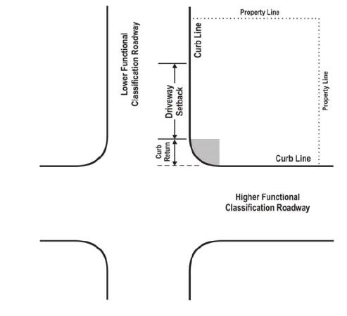
(3) Restrictive Median Curbs. Except for local access and local access residential roadways, restrictive median curbs shall be used to restrict turning and crossing movements as follows:
(a) If access spacing outlined in Tables 1 and 2 cannot be met, median barrier curbs shall be installed the entire distance between public street or signalized intersections on either side of the proposed access, to restrict left turn and crossing movements at the proposed access, unless the city determines that a reduced length of median barrier will provide an acceptable level of traffic safety;
(b) At signalized intersections on principal arterials, the length of restrictive median curbs shall be equal to the driveway spacing distance determined by Table 2, regardless of whether or not driveways exist;
(c) At intersections with left turn lanes on principal arterials, minor arterials, and neighborhood collectors, the length of restrictive median curbs shall be equal to the left turn lane storage length, except as may be required by subsections (3)(a) and (b) of this section; and/or
(d) The director shall determine restrictive median curb types and placements.
(4) Turn Lane Warrants.
(a) Turn lanes (left and right) may be warranted at unsignalized intersections, and should be evaluated using appropriate left or right turn lane warrants utilizing standards adopted by the city or WSDOT depending on which facility is being analyzed.
(b) At signalized intersections, a transportation impact analysis should be used to determine the need for left or right turn lanes and their required storage length. (Ord. 3060 § 1, 2008).
12.60.070 Transportation impact analysis review process.
If a connection permit requires a transportation impact analysis (TIA), city staff will review and process the TIA as follows. At the director’s discretion, the city may retain a consultant to review the TIA and make recommendations to the city regarding its content, findings, and recommendations.
(1) Review of TIA. The city will review the TIA submitted by the applicant. If the city agrees with the findings of the TIA, the recommended mitigation measures will be included in the SEPA and/or connection permit.
(2) Review of TIA with Applicant. Upon review of the applicant’s TIA, if the city does not agree with the findings and recommendations of the TIA, the city will meet with the applicant to review the TIA findings and the city’s different findings. If the applicant accepts the city’s findings, recommended mitigation measures will be included in the SEPA and/or connection permit.
(3) Peer Review. If the city does not agree with the TIA findings and recommendations, and the applicant does not accept the city’s findings and recommendations, the applicant may choose, at the applicant’s cost, to conduct a traffic engineer peer review of the TIA. Such peer review must be conducted by a traffic engineering consultant acceptable to the city, and the applicant shall pay all costs to complete the peer review. If the peer review supports the findings of the applicant’s TIA, the recommended mitigations will be included in the SEPA. If the peer review does not support the findings of the applicant’s TIA and supports the city’s findings or presents different findings, the recommended mitigation measures will be included in the SEPA and/or connection permit. If the applicant does not accept the mitigation measures, the applicant may appeal the mitigation measures in accordance with the provisions of Chapter 1.32 LMC. The SEPA determination will not be made until the appeal process has been completed. (Ord. 3060 § 1, 2008).
12.60.080 Severability.
The provisions of this chapter and the ordinances enacting and amending said chapter are declared to be separate and severable. The invalidity of any clause, sentence, paragraph, subdivision, section or portion of this chapter or the ordinances enacting and amending said chapter, or the invalidity of the application thereof to any person or circumstance shall not affect the validity of the remainder of this chapter or the ordinance enacting said chapter or the validity of its application to other persons or circumstances. (Ord. 3060 § 1, 2008).