


Chapter 18.40
DEVELOPMENT STANDARDS
Sections:
18.40.020 Interpretations of tables.
18.40.030 Densities and dimensions – Residential zones.
18.40.040 Densities and dimensions – Commercial zones.
18.40.060 Parking, storage and habitation of recreational vehicles.
18.40.070 Parking and storage of vehicles.
18.40.080 Recreation or open space required.
18.40.090 Sight distance triangle requirements.
18.40.100 Trash and recycling enclosures.
18.40.110 Mechanical and other equipment screening.
18.40.120 Off-street parking standards.
18.40.130 Landscaping requirements.
18.40.140 Tree removal, retention and replacement.
18.40.150 Large commercial use requirements.
18.40.010 Purpose.
The purpose of this chapter is to establish dimensional standards, density limits, and parking, landscaping and other requirements of general application to new development. (Ord. O-16-598 § 1(B) (Exh. B); Ord. O-00-133 § 1; Ord. O-99-109 § 1).
18.40.020 Interpretations of tables.
A. MVMC 18.40.030 and 18.40.040 contain the general density and dimensional standards for the various zones and the limitations specific to a particular zoning district. MVMC 18.40.050 through 18.40.100 contain additional rules, exceptions and methodologies that apply to development in the City of Maple Valley.
B. The density and dimension tables are arranged in a matrix format on two separate tables and are delineated in two general land use categories:
1. Residential; and
2. Commercial and business park uses.
C. Development standards are listed down the left side of both matrices and the zones are listed at the top. The matrix cells contain the minimum or maximum dimensional requirements of the zone. The superscript numbers in the matrix identify specific requirements applicable either to a specific use or zone. A blank cell indicates that there are no specific requirements. If more than one standard appears in a cell, each standard will be subject to any applicable superscript footnote following the standard. (Ord. O-16-598 § 1(B) (Exh. B); Ord. O-00-133 § 1; Ord. O-99-109 § 1).
18.40.030 Densities and dimensions – Residential zones.
A. Table.
|
Density and |
Zones
|
|||||
|---|---|---|---|---|---|---|
|
R-4 |
R-6 |
R-8 |
R-12 |
R-18 |
R-24 |
|
|
Maximum Density |
4 du/acre |
6 du/acre |
8 du/acre |
12 du/acre |
18 du/acre |
24 du/acre |
|
Minimum Lot Width3 |
30 feet |
30 feet |
30 feet |
30 feet |
30 feet |
30 feet |
|
Minimum Front Setback2 |
10 feet1 |
10 feet1 |
10 feet1 |
10 feet1 |
10 feet1 |
10 feet1 |
|
Minimum Side Setback2, 3 |
5 feet |
5 feet |
10 feet |
10 feet |
10 feet |
10 feet |
|
Minimum Rear Setback2, 3 |
10 feet |
10 feet |
20 feet5 |
20 feet5 |
20 feet5 |
20 feet5 |
|
Maximum Height4 |
35 feet |
35 feet |
35 feet |
35 feet |
35 feet |
60 feet |
|
Maximum Impervious Surface Coverage |
55% |
70% |
75%5 |
80%5 |
80%5 |
80%5 |
B. Specifications.
1. At least 20 linear feet of driveway shall be provided between any garage, carport, or other fenced parking area and the street property line. The linear distance shall be measured along the centerline of the driveway from the access point to such garage, carport or fenced area to the street property line.
2. Projections may extend into required setbacks as follows:
a. Fireplace structures, bay or garden windows, enclosed stair landings, closets, utility meters or similar architectural features may project into any setback, provided such projections are:
i. Limited to two per facade;
ii. Not wider than 10 feet; and
iii. Not more than 18 inches into an interior setback or 24 inches into a street setback.
b. Uncovered porches and decks which exceed 18 inches above the finished grade may project 18 inches into interior setbacks and five feet into the street setback.
c. Uncovered porches and decks not exceeding 18 inches above the finished grade may project to the property line.
d. Eaves may not project more than 18 inches into an interior setback or 24 inches into a street setback.
e. Residential accessory structures, trellises, sheds and play equipment totaling less than 200 square feet per site may be located in the required setback when:
i. Located in the rear or side setback of a pipestem or alley load lot or in rear setback of any lot other than pipestem or alley load lot; and
ii. No portion of the building or structure is located closer than 40 inches to the property line, except that roof eaves may be located no closer than 36 inches; and
iii. The total amount of all such structures on site is limited to 25 percent or less of the length of the property lines associated with the setbacks in which the structure is located; and
iv. The height of residential accessory structures, trellises, sheds and play equipment containing enclosed areas is no more than eight and one-half feet; and
v. The height of play equipment containing no enclosed areas is no more than 10 and one-half feet.
3. These standards may be modified under the provisions for zero-lot-line and townhouse developments. Interior side setbacks may be eliminated in zero-lot-line and townhouse developments. Rear setbacks may be reduced by up to 50 percent; provided, that any portion of a structure located in the standard (prereduction) rear setback area shall not exceed a height of 15 feet.
4. The maximum height allowed may be increased pursuant to incentives in MVMC 18.40.140(G)(2).
5. Single-family detached developments in R-8 through R-24 zones shall be subject to the development standards applicable to the R-6 zone (MVMC 18.30.030(B)(12)).
C. Calculating Density. The allowed density, as shown in density and dimensional tables below, represents the maximum number of dwelling units that may occupy an acre of land, exclusive of accessory dwelling units.
1. Calculations. When calculating allowed density for any given site in the City, the gross area of the site is multiplied by the allowed density per acre that applies to the zone where the site is located. The result is the maximum number of units (other than ADUs) that may occupy that site. Results that include fractional or decimal values shall be rounded down to the nearest whole number for the purposes of calculating density. (Ord. O-17-620 § 2; Ord. O-16-598 § 1(B) (Exh. B); Ord. O-07-351 § 9; Ord. O-00-133 § 1; Ord. O-99-109 § 1).
18.40.040 Densities and dimensions – Commercial zones.
A. Table.
|
Density and Dimensional Standards |
Zones |
||||||
|---|---|---|---|---|---|---|---|
|
Neighborhood Business |
Community Business |
Public |
Park, Recreation, Open Space |
Town Center |
Regional Employment Center |
Regional Learning and Technology Center |
|
|
Maximum Density |
12 du/ac1 |
24 du/ac1 |
N/A |
N/A |
24 du/ac1 |
N/A |
N/A |
|
Minimum Street Setback5, 7 |
10 feet2 |
10 feet2 |
20 feet |
20 feet |
10 feet2 |
10 feet2 |
10 feet2 |
|
Minimum Interior Setback5 |
20 feet3 |
20 feet3 |
20 feet |
20 feet |
20 feet3 |
20 feet3 |
20 feet3 |
|
Maximum Height6 |
35 feet |
45 feet |
35 feet 85 feet10 |
35 feet |
45 feet |
45 feet8 85 feet9 |
45 feet8 85 feet9 |
|
Maximum Impervious Surface Coverage |
80% |
80% |
80% |
80% |
80% |
80% |
80% |
B. Specific Requirements.
1. These densities are allowed only in conjunction with a permitted principal use and not for stand-alone residential development.
2. Service station pump islands shall be placed no closer than 25 feet from the right-of-way.
3. This setback is required only from property lines abutting Residential zones. No interior setback is required from property lines in Commercial zones that abut nonresidential zones. Building code and fire code setback or building separation requirements may apply.
4. Structures, or those portions of structures, within 50 feet of property lines adjoining Residential zones shall not exceed 35 feet in height. An additional 10 feet of building height may be earned through the amenity incentive system, for a total of 55 feet for buildings greater than 100 feet from property lines adjoining Residential zones.
5. Projections may extend into required setbacks as follows:
a. Fireplace structures, bay or garden windows, enclosed stair landings, closets, utility meters and vaults or similar architectural features may project into any setback, provided such projections are:
i. Limited to two per facade;
ii. Not wider than 10 feet; and
iii. Not more than 18 inches into an interior setback or 24 inches into a street setback.
b. Uncovered porches and decks which exceed 18 inches above the finished grade may project 18 inches into interior setbacks and five feet into the street setback.
c. Uncovered porches and decks not exceeding 18 inches above the finished grade may project to the property line.
d. Eaves may not project more than 18 inches into an interior setback or 24 inches into a street setback.
6. The maximum height allowed may be increased pursuant to incentives in MVMC 18.40.140(G)(2).
7. Street setbacks may be reduced or modified in accordance with the commercial design standards in MVMC 18.70.030.
8. Structures, or those portions of structures, within 50 feet of Residential zones shall not exceed 35 feet in height.
9. Structures dedicated to manufacturing, educational/vocational, and office uses may be allowed up to 85 feet in height subject to the following restrictions:
a. On sites of 10 acres or more; and
b. The required setbacks from residentially zoned properties shall be 20 feet and increased three feet horizontally for each foot of building height exceeding 35 feet; and
c. The required landscape buffers in MVMC 18.40.130(F)(2) shall be increased 0.25 feet (three inches) for each foot of building height exceeding 35 feet.
10. Structures dedicated to senior high school educational uses located within Public zones may be allowed up to 85 feet in height. (Ord. O-21-734 § 1; Ord. O-16-598 § 1(B) (Exh. B); Ord. O-14-564 § 2 (Exh. A); Ord. O-12-513 § 1; Ord. O-12-499 § 7; Ord. O-12-490 § 7; Ord. O-11-440 § 1; Ord. O-07-351 § 10; Ord. O-03-235 § 1; Ord. O-00-133 § 1; Ord. O-99-109 § 1).
18.40.050 Fences.
Fences can be installed and maintained in accordance with the following requirements:
A. In all residentially zoned areas, fences may be installed up to four feet in height around or in the required front setback area, except as modified to 42 inches by the sight triangle requirements of MVMC 18.40.090. Fences up to six feet in height may be installed on side and rear property lines (outside the required front setback area).
B. In all other zones, fences may be installed up to eight feet in height except that fences may exceed eight feet in height around athletic fields in Public zones; provided, that the following requirements are met:
1. Along street frontages, all fences shall be set back one foot for every foot of fence height. This setback shall be landscaped according to Type II landscaping requirements of this code;
2. A setback area shall not be required for fences along interior property lines if the Commercial zoned property is adjacent to or abuts nonresidentially zoned property. A landscaped setback area as set forth in subsection (B)(1) of this section is otherwise required.
C. Special regulations for all zones are as follows:
1. Fences over six feet in height in nonresidential zones shall be subject to the requirements of the applicable building codes;
2. Fence height shall be measured from the elevation of the finished grade at the base of the fence, on the exterior side of the fence;
3. No fence may be constructed if it creates a hazard to users of the public right-of-way or to nearby property;
4. All fences shall comply with the sight distance triangle requirements contained in MVMC 18.40.090;
5. Electrical fences are not permitted, except for livestock fencing.
D. Fences located on a retaining wall or berm within a required setback area are permitted subject to the following requirements:
1. In all zones:
a. The total height of the fence and the retaining wall or berm upon which the fence is located shall not exceed a height of 12 feet. This height shall be measured from the top of the fence to the ground on the low side of the retaining wall or berm; and
b. The total height of the fence itself, measured from the top of the fence to the top of the rockery, retaining wall or berm, shall not exceed six feet.
2. Any portion of the fence above a height of eight feet, measured to include both the fence and the retaining wall or berm (as described in subsection (D)(1)(a) of this section), shall be an open-work fence.
3. There shall be a minimum of four feet of horizontal separation between the building and any proposed retaining wall or berm.
4. Any retaining wall that is higher than four feet will require a minimum four-foot-high fence.
E. The Community Development Director may approve a modification to the combined height limit for fences and retaining walls if the modification is necessary because of the size, configuration, topography, or location of the subject property, to provide the property with the use rights and privileges permitted to other properties in the vicinity or zone in which the property is located, and the modification will not be materially detrimental to the public welfare or to abutting properties. (Ord. O-16-598 § 1(B) (Exh. B); Ord. O-14-564 § 3 (Exh. A); Ord. O-10-415 § 3; Ord. O-99-109 § 1).
18.40.060 Parking, storage and habitation of recreational vehicles.
Recreational vehicles (including watercraft) shall not be parked in required front or side-street setbacks. Recreational vehicles shall not be used for living purposes. (Ord. O-16-598 § 1(B) (Exh. B); Ord. O-99-109 § 1).
18.40.070 Parking and storage of vehicles.
No more than one vehicle of any kind in an inoperable condition (includes vehicles not currently licensed) shall be stored or parked outside on any residentially zoned property for more than 30 days. (Ord. O-16-598 § 1(B) (Exh. B); Ord. O-99-109 § 1).
18.40.080 Recreation or open space required.
A. Residential developments of more than four lots or units, including subdivisions, multifamily uses, and mixed residential-commercial developments, shall provide on-site recreation space for leisure, play and sport activities at the following rates:
1. Residential subdivisions and townhouses developed at a density of eight units or fewer per acre – 435 square feet per unit, except as provided in subsection (F) of this section;
2. Multifamily uses developed at a density of greater than eight units per acre, and mixed residential-commercial developments:
a. Studio and one bedroom – 100 square feet per unit;
b. Two bedroom – 285 square feet per unit;
c. Three or more bedrooms – 435 square feet per unit;
d. Except as provided in subsection (F) of this section.
B. Residential developments of more than four lots or units, including subdivisions, multifamily uses and mixed residential-commercial developments, where demonstrated that recreation space is not as beneficial or serves its intended purpose, shall provide open space in lieu of recreation areas according to the following guidelines:
1. Developments consisting of a lower density and number of units will generally demonstrate less need for recreational areas and include more open space dedication for meeting these provisions;
2. As development increases in the number of units and density, they will generally necessitate more recreational area and include more recreational area dedication for meeting these provisions;
3. Site-specific circumstances, such as proximity to existing recreational areas, adjacent land uses, and presence of environmentally sensitive areas, may be considered when demonstrating an acceptable amount of recreational or open space area;
4. Adopted City policies and goals related to recreational and open space areas may be considered when demonstrating an acceptable amount of recreational or open space area.
C. Any outdoor recreation or open space shall be developed as follows:
1. At least 80 percent of the recreation space will be flat and usable for either active and/or passive recreation uses;
2. Recreation space and open space must be located on the site of the proposed development;
3. Recreation space and open space will have no dimensions less than 20 feet (except pathways);
4. Recreation space will be reasonably central, accessible, and convenient to the residents of residential development it serves;
5. Recreation space and open space must provide access by street frontage, trail, or walkway to any existing or planned public community park, public open space or trail system, which may be located on adjoining property;
6. Where possible, pathways will be developed to provide off-street access to the recreation space or open space. The minimum width of these pathways will be no less than eight feet and will be landscaped, and, if the recreation space or open space is located on a street classified as neighborhood collector or above, it shall incorporate buffers and/or barriers necessary to reduce hazards from passing vehicles.
D. Indoor recreation areas may be credited toward the total recreation or open space requirement when the City determines that such areas are located, designed and improved in a manner that provides recreational opportunities that are functionally equivalent to recreational opportunities available outdoors. For senior citizen assisted housing, indoor recreation areas need not be functionally equivalent but may include social areas, game and craft rooms, and other multipurpose entertainment and education areas.
E. Stormwater runoff vaults may be designed and used as recreation space for activities including, but not limited to, tennis courts and sports courts.
F. Recreation Space – Fees in Lieu of Park Dedication. Fees provided in lieu of on-site recreation or open space may be accepted under exceptional circumstances as determined by special criteria set forth by the Director of Community Development. Such fees-in-lieu shall be the least desirable method, and shall be based on the value of the improved land at the time of application review.
1. Subdivisions, multifamily uses, and mixed residential-commercial developments of greater than four units and fewer than 25 units may pay a partial fee-in-lieu of on-site recreation or open space.
2. When determined by the Director of Community Development that less on-site recreation or open space may be possible as per subsections (A)(1) and (A)(2) of this section, a fee-in-lieu may be accepted for the balance of the requirement.
G. On-Site Recreation – Play Areas Required.
1. All subdivisions, multifamily uses, and mixed residential-commercial developments with 25 or more units, excluding age-restricted senior citizen housing, shall provide tot/children play areas within the required recreation space on site, except when facilities are available within one-quarter mile that are developed as public parks or playgrounds and are accessible without crossing of arterial streets.
2. If any play apparatus is provided in the play area, the apparatus shall meet consumer product safety standards for equipment, soft surfacing and spacing, and shall be located in an area that is:
a. At least 400 square feet in size with no dimension less than 20 feet; and
b. Adjacent to main pedestrian paths or near building entrances.
H. On-Site Recreation – Maintenance of Recreation Space or Dedication.
1. At the sole discretion of the City and subject to approval from the City Council, recreation space as defined in MVMC 18.20.020(R), and meeting the requirements of subsections (A) and (B) of this section, may be dedicated as a public park in lieu of providing the on-site recreation space required above when the following criteria are met:
a. The dedicated land provides one or more of the following:
i. Shoreline access;
ii. Regional trail linkages;
iii. Habitat linkages;
iv. Recreation facilities; or
v. Heritage sites; and
b. The dedicated area is located within the Maple Valley City limits.
2. Unless the recreation space is dedicated to the City pursuant to subsection (H)(1) of this section, maintenance of any recreation space retained in private ownership shall be the responsibility of the owner or other separate entity capable of long-term maintenance and operation in a manner acceptable to the parks division. (Ord. O-16-598 § 1(B) (Exh. B); Ord. O-11-440 § 2; Ord. O-06-328 § 4).
18.40.090 Sight distance triangle requirements.
Except for utility poles and traffic control signs, the following sight distance provisions shall apply to all intersections and site access points in Multifamily and Commercial zones:
A. A sight distance triangle area as determined below shall contain no fence, berm, vegetation, on-site vehicle parking area, signs or other physical obstruction between 42 inches and eight feet above the existing grade:
1. Trees, overhangs, eaves cannot extend below eight feet;
2. Hedges, shrubs, retaining walls, fences are limited to 42 inches in height;
B. The sight distance triangle shall be as follows:
1. A street intersection shall be determined by measuring 15 feet along both street property lines beginning at their point of intersection. The third side of the triangle shall be a line connecting the endpoints of the first two sides of the triangle; or
2. A site access point shall be determined by measuring 15 feet along the street lines and 15 feet along the edges of the driveway beginning at the respective points of the intersection. The third side of each triangle shall be a line connecting the endpoints of the first two sides of each triangle; and
C. The Director may require modification or removal of structures or landscaping located in a required sight triangle, if:
1. Such improvements prevent adequate sight distance to drivers entering or leaving a driveway; and
2. No reasonable driveway relocation alternative for an adjoining lot is feasible. (Ord. O-16-598 § 1(B) (Exh. B); Ord. O-99-109 § 1).
18.40.100 Trash and recycling enclosures.
Developments shall provide storage space for the collection of trash and recyclables as follows:
A. The storage space for multifamily residential developments shall be located in collection points as follows:
1. The required storage areas shall be dispersed in collection points throughout the site when a residential development comprises more than one building;
2. Collection points may be located within residential buildings, in separate buildings/structures without dwelling units or outdoors;
3. Collection points shall be located in a manner so that the swing of any collection point gate does not obstruct pedestrian or vehicle traffic or access to parking or that the gate or any hauling truck does not project into any public right-of-way;
4. Trash and recycling enclosures shall meet the requirements of the Community Design Guidelines.
B. The storage space for nonresidential developments shall be located in collection points as follows:
1. Storage space may be allocated to a centralized collection point;
2. Outdoor collection points shall be located in a required setback or landscaped area, or designated service areas within Public zones;
3. Collection points shall be located in a manner so that the swing of any collection point gate does not obstruct pedestrian or vehicle traffic or access to parking or that the gate or any hauling truck does not project into any public right-of-way;
4. Dimensions of the collection points shall be sufficient width and depth to enclose containers for trash and recyclables;
5. Architectural design of any structure enclosing an outdoor collection point or any building primarily used to contain a collection point shall be consistent with the design of the primary structure(s) on the site;
6. A six-foot wall or sight-obscuring fence shall enclose any outdoor collection point. Appropriate landscaping shall also be required as determined by the Director;
7. Enclosures for collection points and buildings used primarily to contain a collection point shall have appropriate width and clearance to accommodate the hauler’s equipment. (Ord. O-16-598 § 1(B) (Exh. B); Ord. O-14-564 § 4 (Exh. A); Ord. O-99-109 § 1).
18.40.110 Mechanical and other equipment screening.
A. Applicability. The requirements of this section shall be imposed for all new development, and construction or placement of new mechanical equipment, other equipment, dumpsters, or recycling bins in or on existing or new buildings. Mechanical equipment should be installed so as not to detract from the appearance of the building or development.
B. Mechanical equipment or other equipment shall be screened from view by a solid, nonreflective visual barrier equal to or exceeding the height, including mounting, of the item being screened.
1. Locate and/or screen roof-mounted and ground level mechanical equipment so as not to be visible from the street, from the ground level of adjacent properties or from adjacent residential areas at higher elevations.
2. Where equipment is exposed to views from a higher elevation, it shall be painted with a nonreflective paint to blend with the roof or background, or be screened.
3. Locate and/or screen utility meters, electrical conduit and other service and utilities apparatus so as not to be visible from the street where feasible. This is intended to include public utilities along the street, where feasible.
4. Garbage, recycling collection and utility areas visible from a public right-of-way, public parking area, walkway, or public open space shall be screened around their perimeter by a wall or fence at least six feet high. Fences should be made of masonry, ornamental metal or wood, or some combination of the three so that they blend with the architecture of the building. The use of chain link, plastic or wire fencing is prohibited. (Ord. O-16-598 § 1(B) (Exh. B); Ord. O-05-304 § 2; Ord. O-99-109 § 1).
18.40.120 Off-street parking standards.
A. Parking Requirements Generally.
1. Off-street parking facilities shall be required for all land uses in accordance with the standards and requirements of this section. Where existing buildings do not now meet these requirements, the provisions of this code in MVMC 18.80.010 through 18.80.090 relating to nonconforming uses, structures, and sites shall apply if proposals for enlarging or increasing capacity of the building or use are made.
2. Off-street parking spaces, when provided in accordance with these regulations, shall be paved with a durable, dust-free surface for vehicle parking, maneuvering and storage.
3. All off-street parking shall be located on the premises except as provided for in this section.
4. Lighting of areas provided for off-street parking shall be full cutoff and installed horizontally or shielded so it does not constitute a nuisance or hazard to adjoining property or passing traffic. Where property used for off-street parking shares a common boundary with any residentially zoned property, the illumination devices shall be directed away from the residentially zoned property.
5. Parking requirements shall be rounded to whole numbers. Fractional requirements less than one-half shall be rounded down. Fractions of one-half or more shall be rounded up.
6. For parking areas with more than 200 spaces, the total number of parking spaces, including reserved employee parking, shall not exceed five percent more than the minimum necessary under this code, except for parking spaces located within a structured parking facility or parking spaces that also serve as park and ride/transit/carpool spaces.
7. Commercial buildings over 5,000 gross square feet shall provide four permanent bicycle spaces and one space for every additional 10,000 gross square feet. For multifamily residential, one space for every two dwelling units. Bicycle parking spaces shall be located within 50 feet of primary entrances except that senior high schools in Public zones may have bicycle parking spaces located further than 50 feet of primary entrances; the final location, type and color of bicycle rack shall be determined by the Community Development Department; provided, that for senior high schools in Public zones the type and color shall be approved by the Director during permit review.
8. The Community Development Director may approve alternative minimum parking requirements for specific uses on specific development sites where the applicant demonstrates, through a parking study prepared by a qualified expert, that the alternative requirement will provide sufficient parking to serve the specific use without adversely impacting other uses and streets in the vicinity. The Director may require the recording of a covenant or other instrument restricting the use of the property to the specific use for which the alternative minimum parking requirement was approved. Review of the study shall be conducted by a City selected consultant at the expense of the developer.
9. Shared Parking Facilities. Shared parking facilities may be provided subject to the approval of the Community Development Director where two or more land uses can be joined or coordinated to achieve efficiency of vehicular and pedestrian circulation, economy of space, and a superior grouping of buildings or uses. When shared parking facilities can be provided, the Community Development Director may reduce the on-site parking requirements based on any of the following criteria:
a. Peak demand occurs at distinctly different times;
b. The minimum required parking for a multi-tenant facility shall be based upon the minimum amount necessary to satisfy the highest average daily peak demand generated by the uses at a single time period. In no case shall the minimum required parking for a multi-tenant facility be less than 60 percent of the total required for all uses in the facility;
c. A covenant or other contract for shared parking between the cooperating property owners is approved by the Director. This covenant or contract must be recorded with King County Records and Elections Division as a deed restriction on both properties and cannot be modified or revoked without the consent of the Director; and
d. If any requirements for shared parking are violated, the affected property owners must provide a remedy satisfactory to the Director or provide the full amount of required off-street parking for each use, in accordance with the requirements of this chapter, unless a satisfactory alternative remedy is approved by the Director. A satisfactory remedy must be provided to the City for approval no later than a period of six months from receiving notification that the requirements for a shared parking agreement have been violated, unless an extension has been approved by the Community Development Director. A remedy could include an off-site parking agreement, revised shared parking agreement or similar agreement that addresses mitigation for parking.
B. The following minimum parking standards shall apply as follows for listed uses:
1. Dwellings.
a. Single-family and townhouse: two parking spaces per single-family dwelling unit.
b. Two-family: two parking spaces per dwelling unit.
c. Multifamily: one parking space per studio or efficiency unit in all sized development. Two parking spaces for each dwelling unit for developments with 49 or fewer dwelling units. For developments of more than 50 units, 1.8 parking stalls per unit.
d. Mobile homes: two parking spaces per mobile home site.
e. Hotels/motels: one parking space for each guest room.
f. Assisted living facility: one space per two units, one space per three employees at maximum shift, and one visitor space per five residents.
g. Retirement community: one space per two bedrooms, one space per three employees at maximum shift, and one visitor space per five residents.
2. Commercial Activities.
a. Banks: five spaces per 1,000 square feet of gross floor area except when part of a shopping center.
b. Professional and business offices: four spaces per 1,000 square feet of gross floor area except when part of a shopping center.
c. Shopping centers: four and one-half spaces per 1,000 square feet of gross floor area except that restaurants, taverns, and lounges are counted as separate uses when total of such establishments exceeds 15 percent of the shopping center gross floor area.
d. Restaurants, taverns and lounges: 10 spaces per 1,000 square feet of gross floor area except when part of a shopping center. For shopping centers exceeding 100,000 square feet, restaurants, taverns and lounges shall be calculated at four parking spaces per 1,000 square feet beyond the 100,000-square-foot threshold.
e. Retail stores, supermarkets, department stores, etc.: four spaces per 1,000 square feet of gross floor area except when part of a shopping center.
f. Other retail establishments; furniture, appliance, hardware stores, etc.: two spaces per 1,000 square feet of gross floor area except when part of a shopping center.
g. Drive-in business: 10 spaces per 1,000 square feet of gross floor area except when part of a shopping center.
h. Motor vehicle repair and services: two and one-half spaces per 1,000 square feet of gross floor area except when part of a shopping center.
i. Recreation instruction/health clubs: 10 spaces per 1,000 square feet of gross floor area.
3. Business Park Activities.
a. Manufacturing, research and testing laboratories, printing, etc.: one space for each 1,000 square feet of gross floor area. For parking requirements for associated office areas, see professional and business office.
b. Warehouses and storage buildings: one-half parking space for each 1,000 square feet of gross floor area.
c. Speculative warehouse and industrial buildings with multiple use or tenant potential: one parking space per 1,000 square feet of gross floor area.
Important Note: This is a minimum requirement and valid for Construction Permit only. Final parking requirements will be based upon actual occupancy and occupancy will be denied for any use that cannot meet the minimum parking requirement.
d. Self-storage facility: a minimum of six parking spaces with additional spaces as required to accommodate accessory uses to the self-storage facility (e.g., office, vehicle rental, caretaker dwelling unit).
4. Recreation and Amusement Activities.
a. Auditoriums, theaters, places of public assembly, stadiums and outdoor sports areas: one parking stall for each four fixed seats or 10 parking stalls for each 1,000 square feet of floor area of main auditorium or of principal place of assembly not containing fixed seats, whichever is greater.
b. Bowling alleys: one parking space for each alley except when part of a shopping center.
c. Dance halls and skating rinks: five parking spaces for each 1,000 square feet of gross floor area, except when located in a shopping center.
d. Golf courses: three parking spaces per hole, plus three and one-half spaces per 1,000 gross square feet of clubhouse facilities.
e. Recreation instruction/health clubs: 10 parking spaces per each 1,000 square feet of gross floor area.
5. Educational Activities.
a. Senior High Schools (Public, Private, and Parochial). The parking requirement shall be determined by the Director based on studies of similar schools. The applicant shall prepare or pay for the preparation of the necessary information and studies. The parameters and required elements of the parking survey and analysis shall be determined on a case-by-case basis by the Director following a preapplication conference.
b. Colleges and Universities, Business and Vocational Schools. The parking requirement shall be determined by the Director based on studies of similar schools. The applicant shall prepare or pay for the preparation of the necessary information and studies. The parameters and required elements of the parking survey and analysis shall be determined on a case-by-case basis by the Director following a preapplication conference.
c. Elementary and Junior High Schools. The parking requirement shall be determined by the Director based on studies of similar schools. The applicant shall prepare or pay for the preparation of the necessary information and studies. The parameters and required elements of the parking survey and analysis shall be determined on a case-by-case basis by the Director following a preapplication conference.
d. Libraries: four spaces per 1,000 gross square feet in office and public use areas.
e. Nursery schools and day care centers: one parking space for each employee plus one space for every five children, plus on-site loading and unloading areas.
6. Medical Activities.
a. Medical and dental offices: five spaces per 1,000 square feet of gross floor area except when part of a shopping center.
b. Convalescent, nursing, and health institutions: one parking space for each two employees plus one space for each three beds.
c. Hospitals: one parking stall for each patient bed.
7. Religious Activities.
a. Religious Facilities. The parking requirement shall be determined by the Director based on studies of similar religious facilities. The applicant shall prepare or pay for the preparation of the necessary information and studies. The parameters and required elements of the parking survey and analysis shall be determined on a case-by-case basis by the Director following a preapplication conference. An applicant may propose to meet peak parking needs through joint parking arrangements or parking management plans.
8. Other Uses. For uses not specifically identified herein, the amount of parking required shall be determined by the Director, based on parking required for similar uses and, if appropriate, documentation provided by the applicant.
9. Mixed Occupancies. In the case of two or more uses in the same building, the total requirements for off-street parking facilities shall be the sum of the requirements for the different uses computed separately, except in shopping centers. Off-street parking facilities for one use shall not be considered as providing required parking facilities for any other use except as permitted under the shared use provisions of this title.
C. Shared Use. The shared use of parking facilities may be authorized for those uses which have dissimilar peak hour parking demand. The following conditions must be fulfilled before a shared use facility is allowed:
1. The parking lot or facility must be located within a radius of 500 feet of the buildings or use areas it is intended to serve;
2. The lot shall be designed to freely circulate and connect all portions of the shared lot without the need to exit the lot to public right-of-way to reach any other portion of the lot;
3. Documentation of dissimilar peak hour parking demands done by a qualified transportation consultant must be provided by the applicant; and
4. The subject property or properties shall be legally encumbered by a recorded reciprocal parking easement or other appropriate means which provides for continuous shared use of the parking facilities. Documentation shall require review and approval of the City Attorney.
D. Loading Space. For all buildings hereafter erected, reconstructed (see Chapter 18.80 MVMC, Nonconforming Provisions), or enlarged, adequate permanent off-street loading space shall be provided if the activity carried on is such that the building requires deliveries to it or shipments from it. Such space shall be shown on the site plan and submitted for approval with other development plans. No portion of a vehicle taking part in loading, unloading or maneuvering activities shall project into a public street, alley or interior pedestrian area. Loading space or maneuvering areas shall be in addition to required off-street parking spaces.
E. Parking Areas. Parking area design and site layout shall limit the size and dimensions of parking areas, and visual impacts associated with large parking areas shall be mitigated to the extent possible, as set forth herein.
1. The maximum size for a single parking area shall be 300 feet by 250 feet. Multiple parking areas on a single site are allowed as long as parking areas are separated pursuant to subsection (E)(3) of this section.
2. Parking Lot Diagram. (Not drawn to scale.)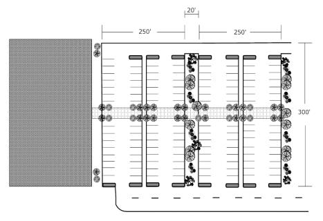
3. Parking Area Separation. Parking area separation and visual buffering shall include the placement of buildings, landscape areas or pedestrian-oriented areas, or any combination thereof, with a linear distance at least equal to 80 percent of the parking area dimension abutting the separation area. Landscape areas must be at least 20 feet in width or 15 feet in width if the landscape area contains at least a three-foot-high berm as depicted in MVMC 18.70.030(B)(3)(a)(i)(B). Landscape areas may be located within an interior parking area or innovative stormwater treatment and/or flow control facility such as bioretention (as defined by the City-adopted KCSWDM). Landscape areas shall be planted with native and drought resistant vegetation.
4. Schools in Public Zones. Parking area requirements for the development of schools in Public zones shall be as approved by the Director during permit review.
F. Size and Design Standards.
1. Standard: nine feet by 19 feet.
2. Compact: eight feet by 17 feet.
3. Parallel: nine feet by 23 feet.
4. Any parking spaces abutting a landscaped area on the driver or passenger side of the vehicle shall provide an additional 18 inches above the minimum space width requirement to provide a place to step other than in the landscaped area. The additional width shall be separated from the adjacent parking space by a parking space division stripe. The parking space depth may be reduced when vehicles overhang a walkway under the following conditions:
a. Wheelstops or curbs are installed; and
b. The remaining walkway provides a minimum of 60 inches of unimpeded passageway for pedestrians.
5. Compact Car Parking.
a. Compact car parking spaces shall be clearly marked or signed.
b. Compact car parking spaces shall not exceed 30 percent of the total spaces in the lot.
6. Reserved Employee Parking.
a. Parking in excess of the minimum number of spaces required by subsection (B) of this section may be reserved for employees.
b. Reserved employee parking shall be clearly identified as such and shall not be used for general public parking.
c. Minimum stall size for reserved employee parking shall be eight and one-half feet by 17 feet.
G. Parking Dimensional Table.
|
Off-Street Parking Bay Width Dimensional Standards |
|||||
|---|---|---|---|---|---|
|
Double Loaded Aisle |
Min. Total Width |
Min. Paved Width |
Single Loaded Aisle |
Min. Total Width |
Min. Paved Width |
|
Standard |
60.0 |
58.0 |
Standard |
42.0 |
40.0 |
|
Compact 1-side |
56.5 |
53.0 |
Compact |
40.0 |
38.5 |
|
Compact 2-sides |
52.0 |
50.0 |
|||
|
Reductions |
Min. Total Width |
Min. Paved Width |
Reductions |
Min. Total Width |
Min. Paved Width |
|
One-way traffic |
-2.0 |
-2.0 |
One-way traffic |
-1.0 |
-1.0 |
|
80-degree |
-0.5 |
-0.5 |
80-degree |
-0.0 |
-0.0 |
|
70-degree |
-1.0 |
-1.0 |
70-degree |
-0.5 |
-0.5 |
|
60-degree |
-1.5 |
-1.5 |
60-degree |
-1.0 |
-1.0 |
|
45-degree |
-3.0 |
-3.0 |
45-degree |
-1.5 |
-1.5 |
|
30-degree |
-5.0 |
-5.0 |
30-degree |
-2.5 |
-2.5 |
|
Back-in only |
0.0 |
-2.0 |
Back-in only |
0.0 |
-2.0 |
|
Off-Street Bay Width for Parallel Parking |
|||||
|
Both sides |
36.0 |
36.0 |
One side |
28.0 |
28.0 |
|
One-way traffic |
-4.0 |
-4.0 |
One-way traffic |
-4.0 |
-4.0 |
H. Paving. All vehicular maneuvering areas, including but not limited to off-street parking, truck and mobile equipment loading, unloading, storage and maneuvering areas, and related accesses to and from public rights-of-way, shall be paved with asphalt or equivalent material, to be approved by the City.
I. Lighting. Lighting of a parking lot or storage area shall illuminate only the parking lot or storage area. All lighting shall be full cutoff installed horizontally and/or shielded to prevent glare or light trespass onto adjoining properties or public rights-of-way. Light standards shall not be located so as to interfere with parking stalls, maneuvering areas, or ingress and egress areas. Lighting shall be a minimum of 1.1 foot-candles and a maximum of eight foot-candles to provide a reasonable level of safety for vehicles and pedestrians, including sufficient light for vision-impaired pedestrians on walkways connecting the building entrances to the street and handicapped parking stalls. (Ord. O-16-598 § 1(B) (Exh. B); Ord. O-14-564 § 5 (Exh. A); Ord. O-12-492 § 4; Ord. O-10-411 §§ 1, 2; Ord. O-09-378 § 2; Ord. O-99-109 § 1).
18.40.130 Landscaping requirements.
A. Purpose. The purpose of this section is to:
1. Provide minimum standards for landscaping in order to maintain and protect property values, preserve significant native vegetation, particularly along major transportation corridors, and enhance the general appearance of the City.
2. Landscaping designs shall utilize native vegetation species and drought-tolerant species, and retain natural vegetation, in order to reduce the impact of development on the water resources of the City. By retaining natural vegetation it can reduce soil erosion and water pollution in the City’s streams and lakes by providing wind breaks, slowing the surface movement of water, reducing the amount of stormwater runoff, and stabilizing soils with their roots and fallen leaves.
3. Respond to State-level mandates for action in such areas as water conservation, energy conservation, enhancement of water quality, and improvement of air quality.
4. Reflect City planning goals, urban design standards, and ecological awareness.
5. Provide an appropriate amount and quality of landscaping related to all land use in the City.
6. Reduce noise pollution by absorbing and deadening excessive and/or unwanted noise and by screening the source of the noise from view.
7. Establish a minimum level of regulation that reflects the purposes of this code.
8. Provide for design flexibility.
B. Applicability.
1. These provisions shall apply to all development applications in the City, with the exception of individual single-family residential and minor or local utility infrastructure; provided, that single-family residential complies with the soil amendments requirements in subsection (B)(2) of this section.
2. All portions of a disturbed site not used for buildings, future buildings, parking and storage or accessory uses shall have the soil moisture-holding capacity restored to that of the original undisturbed soil native to the site to the maximum extent practicable. The soil in any area that has been compacted or that has had some or all of the duff layer or underlying topsoil removed shall be amended to mitigate for lost moisture-holding capacity. The amendment shall take place between May 1st and October 1st. The topsoil layer shall be a minimum of eight inches thick, unless the applicant demonstrates that a different thickness will provide conditions equivalent to the soil moisture-holding capacity native to the site. The topsoil layer shall have an organic matter content of between five to 10 percent dry weight and a pH suitable for the proposed landscape plants. When feasible, subsoils below the topsoil layer should be scarified at least four inches with some incorporation of the upper material to avoid stratified layers. Compost used to achieve the required soil organic matter content must meet the definition of “composted materials” in WAC 173-350-220. The soil quality design guidelines listed above can be met by using one of the following two options:
a. Option 1: Amend existing site topsoil or subsoil at a rate of eight cubic yards of compost per 1,000 square feet disturbed soil area, spread at a two-and-one-half-inch depth, and rototilled in eight to 12 inches deep.
b. Option 2: Import topsoil mix of sufficient organic content (five to 10 percent dry weight), pH (6.0 to 8.0), and depth to meet the requirements.
C. Landscape Plan Approval.
1. Except as set forth in subsection (B) of this section, no permit shall be issued to erect, construct or undertake any development project resulting in a new structure or expanding the footprint of an existing structure without prior approval of a landscape plan by the City.
2. Required landscape plans shall be prepared by a landscape design professional (landscape architect, certified landscaper, certified nursery professional, etc.), certified or registered by the State of Washington.
D. General Landscaping Requirements – All Zones.
1. All portions of a lot not used for buildings, future buildings, parking, storage or accessory uses, and proposed landscaped areas shall be retained in a “native” or predeveloped state or restored to such state with appropriate enhanced plantings as determined by the Director; provided, that schools in Public zones shall not be subject to this requirement.
2. Slopes in areas that have been landscaped with lawn shall generally be a three-to-one ratio or less, width to height (horizontal to vertical), to assist in maintenance and to allow irrigation systems to function efficiently.
3. Type III landscaping, defined in subsection (E)(3) of this section, shall be placed outside of sight-obscuring fences abutting public rights-of-way and/or access easements.
4. With the exception of lawn areas, new landscaping materials (i.e., trees, shrubs and groundcover) shall consist of drought-tolerant species and Pacific Northwest adaptive vegetation. All developments are required to include native Pacific Northwest and drought-tolerant plant materials for all projects.
5. Deciduous trees shall have a caliper of at least two inches at the time of planting measured four and one-half feet above the root ball or root.
6. Evergreen trees shall be a minimum six feet in height measured from treetop to the ground at the time of planting.
7. Shrubs shall be a minimum of 12 to 24 inches in height (measured from top of shrub to the ground) at the time of planting.
8. Groundcover shall be planted and spaced to result in total coverage of a landscaped area within three years of planting.
9. Areas planted with grass/lawn shall:
a. Constitute no more than 40 percent of landscaped areas; provided, there shall be an exception for biofiltration swales, except for schools in Public zones; and
b. Be a minimum of five feet wide at the smallest dimension.
10. Grass and required landscaping areas shall contain at least two and one-half inches of compost or imported topsoil with five to 10 percent soil organic matter content.
11. Existing clay or sandy soils where landscaping is to be installed shall be augmented with an organic supplement.
12. Landscape areas shall be covered with at least three inches of mulch to minimize evaporation.
13. Mulch shall be used in conjunction with landscaping in all planting areas to assist vegetative growth and maintenance or to visually complement plant material, except that undisturbed native vegetation need not be mulched. Nonvegetative material shall not be an allowable substitute for plant material.
14. Landscaping and fencing shall not violate the sight distance safety requirements at street intersections and points of ingress/egress for the development.
15. All tree types shall be spaced appropriately for the compatibility of the planting area and the canopy and root characteristics of the tree.
16. Foundation landscaping is encouraged to minimize impacts of the scale, bulk and height of structures.
17. All loading areas shall be fully screened from public rights-of-way or nonindustrial/manufacturing uses with Type I landscaping.
18. Use of products made from post-consumer waste is encouraged whenever possible.
19. Walkways, decorative paving, fountains, benches, picnic tables and other features or amenities are encouraged in landscaping areas. These features are in addition to the landscaping requirement, not in lieu of such requirement.
E. Landscaping Types.
1. Type I – Solid Screen.
a. Purpose. Type I landscaping is intended to provide a solid sight barrier to totally separate incompatible land uses. This landscaping is typically found between residential and incompatible nonresidential land use zones (e.g., business park uses and Residential, etc.), and around outdoor storage yards, service yards, loading areas, mechanical or electrical equipment, utility installations, trash receptacles, etc.
b. Description. Type I landscaping shall consist of evergreen trees planted no more than 20 feet on center in a triangular pattern; shrubs and groundcover which will provide a 100 percent sight-obscuring screen within three years from the time of planting; or a combination of approximately 75 percent evergreen and 25 percent deciduous trees (with an allowable five percent variance), planted no more than 20 feet on center in a triangular pattern, with shrubs and groundcover backed by a sight-obscuring fence. Shrub and groundcover spacing shall be appropriate for the species type, and consistent with the intent of this section.
2. Type II – Visual Screen.
a. Purpose. Type II landscaping is intended to create a visual separation that may be less than sight-obscuring between incompatible land use zones. This landscaping is typically found between Commercial and business park uses; High Density Multifamily and Single-Family Residential zones; Commercial and Residential zones; and to screen business park uses from the street.
b. Description. Type II landscaping shall be evergreen or a combination of approximately 60 percent evergreen and 40 percent deciduous trees, with an allowable five percent variance, planted no more than 20 feet on center in a triangular pattern, interspersed with large shrubs and groundcover. A sight-obscuring fence may be required if it is determined by the City that such a fence is necessary to reduce site-specific adverse impacts to the adjacent land use. Shrub and groundcover spacing shall be appropriate for the species type and the intent of this section.
3. Type III – Visual Buffer.
a. Purpose. Type III landscaping is intended to provide partial visual separation of uses from streets and between compatible uses so as to soften the appearance of parking areas and building elevations.
b. Description. Type III landscaping shall be a mixture of evergreen and deciduous trees planted no more than 30 feet on center in a triangular pattern and interspersed with shrubs and groundcover. Shrub and groundcover spacing shall be appropriate for the species type and the intent of this section.
4. Type IV – Open Area Landscaping.
a. Purpose. Type IV landscaping is primarily intended to provide visual relief and shading while maintaining clear sight lines, and is typically used within parking areas.
b. Description. Type IV landscaping shall consist of trees planted with supporting shrubs and groundcover. Shrubs shall be pruned at 40 inches in height above pedestrian or vehicle grade (whichever is higher), and the lowest tree branches shall be pruned to keep an approximate eight-foot clearance from the ground. Tree, shrub, and groundcover spacing shall be appropriate for the species type and the intent of this section. Vegetated LID facilities (bioretention, rain gardens, and dispersion), consistent with the intent of this section, are allowed. See subsection (G) of this section for location of Type IV landscaping.
F. Landscaping Requirements by Zoning District.
1. Multifamily Residential, R-8 – R-24.
a. Type III landscaping of a minimum width of 10 feet shall be provided along all perimeter lot lines, except as provided in subsection (F)(1)(b) of this section.
b. Type I landscaping of a minimum width of 10 feet shall be provided along the perimeter abutting Single-Family zones (R-4 through R-6).
c. The requirements of subsection (G) of this section for parking area and perimeter parking area landscaping shall apply.
2. Community Business, CB; Town Center, TC; Regional Employment Center, REC; and Regional Learning and Technology Center, RLTC.
a. Type III landscaping of a minimum width of 10 feet shall be provided along all properties abutting public rights-of-way and ingress/egress easements.
b. Type I landscaping of a minimum width of 20 feet shall be provided along the perimeter of property abutting a Residential zoning district.
c. The requirements of subsection (G) of this section for parking area and perimeter parking area landscaping shall apply.
3. Neighborhood Business, NB.
a. Type III landscaping of a minimum width of 10 feet shall be provided along the perimeter of parking areas abutting public rights-of-way.
b. Type I landscaping of a minimum width of 20 feet shall be provided along the perimeter of the property abutting a Residential zoning district.
c. The requirements of subsection (G) of this section for parking area and perimeter parking area landscaping shall apply.
4. Park, Recreation, Open Space, PRO. Landscaping requirements are to be determined by the City on a project-by-project basis dependent on the proposed use and surrounding zoning districts.
G. Parking Lot Landscaping.
1. Purpose. The purpose of this section is to mitigate adverse impacts created by parking lots which include noise, glare and increased heat, increased stormwater runoff and pollution, and to improve the physical appearance of parking lots.
2. Type IV Landscaping. Type IV landscaping shall be provided within surface parking areas as follows:
a. All new Commercial; Park, Recreation, Open Space; and multifamily developments with parking for five or more vehicles, and subdivisions or PUDs with common parking areas for five or more vehicles, shall provide 25 square feet per parking stall.
b. Landscaping along driveways and at building entrances may be counted toward the Type IV landscaping requirement, even if not fully within the parking area.
c. Landscape Islands. Landscape islands shall be a minimum size of 100 square feet, with a minimum width of six feet at the narrowest point. At least one tree shall be planted in each landscape island. Islands shall be provided at the ends of all rows of parking, between loading doors or maneuvering areas and parking areas or stalls. Islands providing stormwater treatment are encouraged in low areas and between parking rows.
i. Any remaining required landscaping shall be dispersed throughout the interior parking area to create shade, reduce the visual impact of the parking lot, and meet applicable design requirements and guidelines.
ii. Deciduous trees are preferred for landscape islands within interior vehicle use areas.
iii. Lawn shall not be permitted in landscape islands less than 200 square feet in size and shall be used only as an accessory planting material to required trees, shrubs, and groundcover.
d. Curbing. Permanent curbing shall be provided in all landscape areas within or abutting parking areas. Where stormwater is intended to be routed into a bioretention facility, wheelstops or curb cuts may be used instead of a continuous permanent curb.
e. Parking Areas/Screening for Rights-of-Way.
i. Parking areas adjacent to public rights-of-way shall incorporate berms at least three feet in height within perimeter landscape areas. Alternatively, the Director may allow the addition of shrub plantings to the required perimeter landscape type, and/or the provision of architectural features of appropriate height with trees, shrubs and groundcover, in a number sufficient to act as an efficient substitute for the three-foot berm. Any such substitution must reduce the visual impact of parking areas and screen the automobiles from public view; provided, that vehicle display areas at automobile sales lots need not be fully screened.
ii. Parking adjacent to Residential zones shall reduce the visual impact of parking areas and buffer dwelling units from light, glare, and other environmental intrusions by providing Type I landscaping within required perimeter landscape areas.
f. Vehicular Overhang.
i. Vehicular overhang into any landscaping area shall not exceed two feet.
ii. No plant material greater than 12 inches in height shall be located within two feet of the curb or other protective barrier in landscape areas adjacent to parking spaces and vehicle use areas.
3. Senior High Schools in Public Zones. The parking lot landscaping requirements for the development of senior high schools in Public zones shall be as approved by the Director during permit review.
H. Performance and Maintenance Standards.
1. Performance.
a. All required landscaping shall be installed prior to final inspection or the issuance of a Certificate of Occupancy (CO), except as provided in subsection (H)(1)(d) of this section.
b. When landscaping is required pursuant to this code, an inspection shall be performed to verify that the landscaping has been installed pursuant to the standards of this code.
c. Upon completion of the landscaping work, the City shall inspect the installation upon request by the applicant.
d. A Temporary Certificate of Occupancy may be issued prior to completion of required landscaping, provided the following criteria are met:
i. An applicant or property owner files a written request with the City prior to a final inspection;
ii. The request shall explain why factors either beyond the applicant’s control, or which would create a significant hardship, prevent the installation of the required landscaping prior to issuance of the CO;
iii. The property owner has demonstrated a good faith effort to complete all required landscaping;
iv. The applicant files a performance security in the form of an assignment of savings with the Department in an amount equal to 150 percent of the cost of completing the landscaping work or, for senior high schools in Public zones, the applicant provides proof of an executed contract for such work with an agreed schedule for completion;
v. The applicant files a consent to access form signed by the property owner allowing a City-hired landscaping contractor access to the property to complete the landscaping work in the event of a default by the applicant.
e. The time period extension for completion of the landscaping shall not exceed 90 days after issuance of a Temporary Certificate of Occupancy except that the Director may grant an extension to senior high schools in Public zones where the applicant submits proof of hardship.
f. Failure to complete landscape installation by an established 90-day extension date shall constitute cause for retrieval of funds by the City from the assigned savings account in order to have the landscaping completed by a City-hired landscaping contractor.
2. Maintenance.
a. Continual maintenance of planted areas shall be the responsibility of the property owner.
b. All portions of any irrigation system shall be continuously maintained in a working condition.
c. The property owner shall also maintain all other aspects of landscaped areas including the removal of trash and debris.
I. Landscape Modification Provisions. The following alternative landscape options may be allowed, subject to approval by the Director, if they accomplish equal or better levels of screening and if they provide an equal or better visual result:
1. The width of the perimeter landscape strip may be reduced up to 25 percent along any portion where:
a. Berms at least three feet in height or architectural barriers at least six feet in height are incorporated into the landscape design; and
b. The landscape materials are incorporated elsewhere on site;
2. When an existing structure precludes installation of the total amount of required site perimeter landscaping, such landscaping material shall be incorporated on another portion of the site;
3. The width of any required perimeter landscaping may be averaged along any individual property line, provided the minimum width is not less than five feet and the landscape area and materials are incorporated elsewhere on site;
4. The width of the perimeter landscaping may be reduced up to 10 percent when a development retains 10 percent of significant trees or 10 significant trees per acre on site, whichever is greater;
5. The landscaping requirement may be modified when existing conditions on or adjacent to the site, such as significant topographic differences, vegetation, structures or utilities, would render application of this chapter ineffective or result in scenic view obstruction.
J. Stormwater Pond Landscaping Standards.
1. Purpose. The purpose of this standard is to improve water quality for the protection of endangered species and reduce maintenance costs for stormwater facilities located in residential developments and make them attractive amenities within the neighborhood and the City.
2. Applicability. These provisions shall apply to all development applications within the City, with the exception of individual single-family residential.
3. Landscape Plan Approval. A landscape design professional (landscape architect, certified landscaper, certified nursery professional, etc.), certified or registered by the State of Washington, shall prepare required landscape plans in accordance to the adopted Surface Water Design Manual and Addenda.
4. Maintenance of the landscaping in the drainage facility shall be the responsibility of the developer or homeowners’ association for two years following facility acceptance by the City of Maple Valley. This includes but is not limited to watering, maintenance, replacement and grooming of all plantings. (Ord. O-23-774 § 2 (Exh. A); Ord. O-21-716 § 12; Ord. O-20-705 § 1; Ord. O-16-598 § 1(B) (Exh. B); Ord. O-14-564 § 6 (Exh. A); Ord. O-12-499 § 8; Ord. O-12-492 § 5; Ord. O-12-490 § 8; Ord. O-11-440 § 3; Ord. O-10-415 § 5; Ord. O-06-328 § 3; Ord. O-02-198 § 1; Ord. O-00-143 § 1; Ord. O-99-109 § 1).
18.40.140 Tree removal, retention and replacement.
A. Purpose. The purpose of this section is to preserve and enhance the valuable natural resources and aesthetic character and image of Maple Valley. The intent is to provide clear guidelines as to when a Clearing and Grading Permit is required for tree removal, incentives for retaining existing trees, to discourage unnecessary clearing and disturbance of land, and to maintain tree-lined corridors along the major arterials.
B. Definitions.
1. “Coverage” is defined as the ratio of the dripline area to the lot area expressed as a percentage.
2. “Dripline area” is the area under the outermost circumference of branches of the tree.
3. “Landmark tree” is defined as any significant tree other than alder or cottonwood that is at least 24 inches in diameter at four and one-half feet from grade.
4. “Large nursery stock” is defined as commercially grown material available at the time of planting that is required to be moved by hydraulic spade and is a minimum size of at least four inches in diameter measured four and one-half feet above grade.
5. “Live crown ratio” is the proportion of length of main stem supporting live branches to the height of the tree.
6. “Planted tree” is defined as any of a number of species of trees less than 12 inches in diameter when planted, but which is expected to become at least 12 inches in diameter at maturity measured at four and one-half feet from grade.
7. “Public property” is defined as City parks, public rights-of-way (e.g., which contain street trees), publicly maintained stormwater facilities, drainage easements, dedicated stormwater tracts and City-owned easements on private property.
8. “Qualified professional” is defined as an individual who through any combination of knowledge, experience, education, and training demonstrates a professional level of understanding in tree care, arboricultural sciences and urban forestry. Qualified professionals must possess the ability to evaluate the health and hazard potential of existing trees, and the ability to prescribe appropriate measures necessary for the preservation of trees during land development. Qualified professionals may include licensed landscape architects, certified consulting arborists, certified arborists, and certified foresters.
9. “Retained significant tree” is defined as a significant tree that is designated for retention and used for demonstrating compliance with canopy coverage requirements or incentives.
10. “Retained tree” is defined as an existing tree designated for retention, excluding cottonwood and alders, that is less than 12 inches in diameter measured four and one-half feet above grade, but greater than six feet tall if evergreen, or two inches in diameter if deciduous. Retained trees must have a live crown ratio of greater than or equal to 50 percent.
11. “Significant tree” is defined as an existing evergreen or deciduous tree, excluding cottonwoods and alders, that is at least 12 inches in diameter measured four and one-half feet above grade.
12. “Street tree” is defined as a tree located in the City right-of-way.
13. “Tree Protection Area (TPA)” is land area set aside with limitations running with the title of the land that prevent activities that will damage the tree or trees within that area.
14. “Windthrow” is the uprooting and overthrowing of trees by the wind.
C. Tree Removal.
1. Tree Removal – Permit Required. This subsection sets forth the circumstances under which a permit is required before removing a tree.
a. No landmark tree may be removed without first obtaining a Clearing and Grading Permit, regardless of lot size.
b. No significant tree may be removed from a lot one-half acre or more in size without first obtaining a Clearing and Grading Permit. Tree removal associated with a building permit, site development permit, subdivision or other land use approval will be reviewed with the associated project and will not require a separate Clearing and Grading Permit.
c. No planted tree or retained tree, planted or retained pursuant to a Landscaping Plan, Native Growth Protection Area, Tree Protection Area, Tree Retention Plan, or other conditions of development, may be removed without first obtaining a Clearing and Grading Permit.
d. Emergencies. A tree that poses imminent danger to persons or property may be removed without a Clearing and Grading Permit; provided, that:
i. The emergency is documented by photograph or video evidence prior to removal; and
ii. Such documentation shall be provided to the City within seven days of removal; and
iii. A post-removal permit is obtained from the City; and
iv. Replanting will be required unless replanting would be detrimental to the existing tree canopy as determined by a certified arborist.
e. Critical Areas. No tree shall be removed from a critical area or its related buffer without first complying with the provisions of Chapter 18.60 MVMC.
f. Exemptions. Trees located within the following areas are exempt from this section’s permitting requirements, when the work is performed by the City, or its designees:
i. Public rights-of-way, for example street trees;
ii. Publicly maintained stormwater facilities;
iii. Drainage easements;
iv. Dedicated stormwater tracts;
v. City-owned easements on private property; and
vi. Minor utility infrastructure.
2. Tree Removal From Public Property – Not Allowed by Private Parties. No tree shall be removed from public property except by its public owner or their designee. Such public owners are required to obtain a Clearing and Grading Permit from the City prior to any tree removal. No street tree shall be removed except by the City, its designee, or as authorized by a Right-of-Way use permit.
D. Timber Management under Forest Practices Act. Applicants for Forest Practice Permits (Class IV – General Permit) for the conversion of forested sites to developed sites are also required to apply for appropriate permits through the City, and are subject to the provisions of this section. For all other Forest Practice Permits (Class II, III, or IV – Special Permit) issued by the DNR for the purpose of commercial timber operations, no Clearing and Grading Permit application is required, but no Development Permits will be issued for six years following tree removal under such DNR permit.
E. Application Requires Tree Retention Plan. All development or redevelopment proposals subject to this section that are not specifically exempt shall include a Tree Retention Plan at the time of application for any required Development Permit. Preparation and submittal of the Plan shall conform to specifications provided by the Director. Tree Retention Plans may be prepared by a qualified professional. An owner may submit for a Clearing and Grading Permit without having a qualified professional prepare a Significant Tree Retention Plan, provided the Plan clearly locates the trees and provides sufficient information for City staff to review the proposal as determined by the Director. The Tree Retention Plan shall analyze:
1. The number of trees and canopy coverage calculation of trees existing on the site;
2. The location and species type of existing significant trees or clusters of trees within and adjacent to the proposed area to be cleared and/or graded, including utility corridors;
3. The species type, size, location, and spot elevation at the base of any landmark tree within the site, unless the requirement is waived by the Director;
4. A statement that describes replacement tree quality as conforming to the American Standards of Nursery Stock (ANSI);
5. Critical areas; and
6. Areas not proposed for clearing or grading, provided such areas do not require a specific survey location of trees.
F. Canopy Coverage Calculation Requirements and Tree Retention Guidelines.
1. A canopy coverage calculation shall be prepared by the applicant for the proposal. The canopy coverage calculation may be merged with the Tree Retention Plan and/or landscaping plan for the proposal. The canopy coverage calculation shall show retention and planting of trees at mature canopy coverage of the total site area to equal or exceed: 15 percent for commercial developments within the TC, NB, PUB, REC, RLTC and CB Zones if there is no residential component. Zones meeting the landscape requirements contained in MVMC 18.40.130(F): 20 percent for all residential development with the R-4, R-6, R-8, R-12, R-18, R-24 and CB Zones (if there is a residential component). Other developments meeting the landscape requirements contained in MVMC 18.40.130(F), on the Legacy Site, will be excluded from canopy coverage from this section, calculated as follows:
a. Retained landmark trees shall be calculated at 1,650 square feet each, regardless of canopy coverage or dripline area, or as marked in the field and measured by the proponent;
b. Retained significant trees shall be calculated at 1,100 square feet each, regardless of canopy coverage or dripline area, or as marked in the field and measured by the proponent;
c. Retained trees shall be calculated at 900 square feet each, regardless of canopy coverage or dripline area;
d. Planted significant trees meeting the minimum planting standard (subsections (R)(2) and (3) of this section) shall be calculated at 300 square feet each;
e. Planted significant trees exceeding the minimum planting standard (subsections (R)(2) and (3) of this section) by 50 percent shall be calculated at 550 square feet each; and
f. Planted significant trees meeting the definition of large nursery stock and exceeding the minimum planting standard (subsections (R)(2) and (3) of this section) by 100 percent shall be calculated at 750 square feet each.
2. For the purposes of meeting the minimum required canopy coverage calculation, trees shall be retained pursuant to the following unranked guidelines, except where determined to be exempt or to constitute a hazard by a qualified professional pursuant to subsection (C)(1)(d) of this section:
a. All trees within critical areas or critical area buffers;
b. Retained trees within the required perimeter landscape buffer width or building setback, whichever is greater;
c. Retained trees inside the site within an area no less than 20 feet of the right-of-way line of Maple Valley Highway SR-169, Kent-Kangley Road SR-516, and Witte Road arterial corridors except for site access requirements;
d. Trees within required open space; and
e. For subdivisions during site development, all trees that are not within cut or fill areas, parking areas or streets, utility corridors, site development requirements imposed by the City, or 20 feet distant of any proposed structure, except that trees retained in single-family lots created by subdivision of property into more than four lots shall not be counted for purposes of meeting required tree canopy coverage.
3. Where demonstrated that a site cannot achieve the minimum canopy coverage through retention pursuant to subsection (F)(2) of this section, planted significant trees may be utilized in Tree Protection Areas pursuant to the following guidelines in order of preference where applicable:
a. Inside the site within a distance of 20 feet or greater of the right-of-way line of Maple Valley Highway SR-169, Kent-Kangley Road SR-516, and Witte Road arterial corridors except for site access requirements. At least 25 percent of replanted trees along these arterial corridors must consist of evergreen trees with a height of 10 to 12 feet or deciduous trees with a three-inch caliper;
b. Within required perimeter buffers or setback areas;
c. Within designated recreation and/or open space areas;
d. Within critical areas or critical area buffers; and
e. Any other locations within the development site, except that trees planted in single-family lots created by subdivision of property into more than four lots shall not be counted for purposes of meeting required tree canopy coverage.
G. Incentive for Retention of Existing Trees and Increased Canopy Coverage. For development proposals subject to tree retention requirements in any zone, and where the proposal contains greater than 20 percent canopy coverage by retained existing trees; provided, that trees retained in protected critical areas or related buffers may not apply towards the required percentages, the following incentives are available individually or in combination:
1. For any retained landmark tree, the actual dripline area of the tree may be credited toward open space or recreational space requirements irrespective of tree location; or
2. Additional building height of 10 feet is permitted up to a maximum height of 45 feet; provided, trees must be retained proximate to the proposed building location(s).
3. If any tree that is saved in conjunction with these bonus provisions is lost in the future for whatever reason, it shall be replaced with large nursery stock approved by the Director.
H. Phased Development Plans. For redevelopment and/or phased new development sites, the Director may approve a partial Tree Retention Plan that is applicable only to a phase of development or redevelopment. A Plan based on phased development does not require a full amount of required trees per acre for each phase individually, provided the Plan for the entire development or proposal meets, or will meet, requirements; provided, however, no incentives may be approved for early phases of construction that rely on trees to be retained in future phases unless the significant Tree Retention Plan is recorded such that future phases are bound by the Plan.
I. Alternative Landscape Option. At the Director’s sole discretion, the Director may approve an alternative landscape option for a high-quality landscape design containing native and ornamental species of landscape materials on sites where the proponent demonstrates to the satisfaction of the Director that planting trees at the required canopy coverage would not be feasible given the proposed use of the property, and/or would require planting at a density that would probably require removal of trees in the future due to the ultimate size of required species.
1. The proponent must show that the alternative landscape plan is of a better quality compared to a plan that would meet the requirements in the above subsections, and retains significant trees or provides planted significant trees in accordance with the following:
a. Existing trees in critical areas and critical area buffers must be retained and/or augmented with trees as appropriate;
b. Existing trees in required perimeter landscape buffers must be preserved;
c. Street trees are provided on streets adjacent to the site;
d. Perimeter buffer areas without existing significant trees include planted significant trees;
e. Significant trees are provided around any open stormwater detention or pollution control ponding or swale areas;
f. Significant tree equivalents are provided internally to parking lot areas;
g. Significant trees are planted adjacent to the structure(s);
h. Street trees are planted within the development; and
i. Street trees are planted in cul-de-sac islands as applicable.
2. Alternative landscape plans must emphasize native plant material and large-scale shrub and small tree species, such as vine maple, as well as ornamental material appropriate and complementary to the proposed use of the site.
J. Utility and Street Easements and Rights-of-Way.
1. For installation or maintenance of major overhead and major underground utilities, such as electrical transmission lines, water or sewer mains or stormwater lines, no tree retention or planting requirements shall be imposed within the easement or right-of-way area.
2. For installation or maintenance of minor overhead and underground utilities, including overhead power distribution lines, water or sewer mains, or stormwater lines, no number of trees per acre of land shall apply for the easement or right-of-way area; provided, however, for each significant tree removed due to installation or maintenance of lines, one planted significant tree is required. The Director shall give consideration to the approval of planted species so as not to create future conflicts with the overhead or underground utilities.
3. For private properties with easements for overhead utilities, no tree retention or significant tree equivalent planting requirements shall apply for the private land area affected by the utility easement.
4. For public and private road construction and maintenance within the right-of-way or grading easements, no tree retention requirement shall apply; provided, retained trees within and along the right-of-way of Maple Valley Highway SR-169, Kent-Kangley Road SR-516, and Witte Road arterial corridors shall be accommodated and provided as a requirement of the design engineering for and maintenance of the road.
K. Tree Windthrow Evaluation and Prevention.
1. Increased tree windthrow potential as a result of impacts to trees on a site shall be evaluated based on the following risk factors:
a. Root system disruption that will extend within an area one to two and one-half times the radius of the canopy;
b. Topography of the site;
c. Whether the tree is deciduous or evergreen;
d. Height of the tree relative to the neighboring trees;
e. Whether the tree is part of a grove.
L. Decision Criteria. The Director shall review the application for a Tree Retention Plan and/or Clearing and Grading Permit and approve the permit, deny the permit, or approve the permit with conditions based on the following criteria:
1. The site design implements the intent of this section; and
2. The Tree Retention Plan conforms to the specific requirements of this section; and
3. The proposal complies with and conforms to all standards and requirements of the underlying permit, if such permit is in addition to the Clearing and Grading Permit.
M. Tree Retention Plan Recording Required. For all nonexempt development and redevelopment sites (except for trees planted or retained within platted single-family residential lots), the Tree Retention Plan shall show Tree Protection Areas (TPAs). Upon approval of the Tree Retention Plan, the Plan shall be recorded together with the following restriction upon the land:
Trees indicated on this property within Tree Protection Areas are to be preserved for environmental, aesthetic, and other purposes. No activities are allowed within the Tree Protection Area that could damage or harm the tree, such as storage of material, disposal of drainage, or filling or grading. Tree removal, or site work or landscaping resulting in the loss of a tree, is subject to fines and tree replacement requirements by order of the City of Maple Valley.
N. Tree Retention Standards.
1. Site Design Standards.
a. To qualify as an existing retained tree, the critical root zone (CRZ) of individual trees, groves, or otherwise designated protected tree area shall include no less than the area of a circle with a radius that extends one foot out from the tree for every inch of trunk dbh, or the area of a circle with radius extending from a tree’s trunk to a point no less than the end of the tree’s longest branch, whichever is greater, and shall be a no disturbance area. Undisturbed areas shall not be impacted by grading, soil disturbance, impervious surfacing, storage of materials, or activity that may compact the soil surface, such as pedestrian use.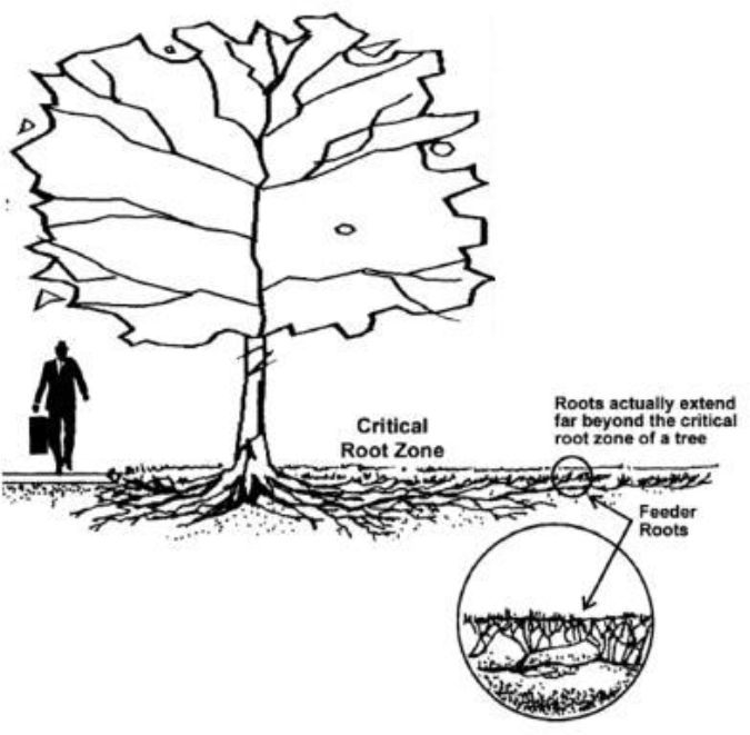
b. Any work within the one-third of the dripline area shall be planned to be done by hand and by methods least disruptive to the tree.
c. For retained trees where the grade in the vicinity of the tree will be either raised or lowered such that surface or subsurface water flow to the tree will be altered, specific provisions for additional irrigation or drainage shall be included in the tree protection notes and details.
d. Tree retention details, including protection notes and fencing or staking installation details, shall be included on the applicable site development plans, and reviewed and approved by the Director prior to approval of the Tree Retention Plan.
2. Construction Standards.
a. Tree protection details, dripline fencing, and no disturbance areas shall be part of all construction plans issued for permit.
b. All dripline areas of retained trees shall be located in the field and confirmed by a City Inspector prior to commencement of construction.
c. Work within dripline areas specifically authorized by approved construction plans shall be done separately from mechanized mass clearing and grading of the site and shall be fenced to exclude the area from mechanized clearing or grading. Methods for work within such areas shall be detailed on the clearing and grading plans, civil engineering plans, utility plans and landscape plans as may be needed to clarify the methods and responsibilties for construction within the dripline area.
d. Tree protection areas shall be fenced prior to construction with orange plastic mesh fencing or approved equivalent.
O. Maintenance Standards. Maintenance in the form of irrigation, fertilization, clearing of vines and other requirements necessary to assure survival of the retained and planted significant trees is required on the private property in perpetuity. The City may inspect and order maintenance at any time. The property owner is responsible for the replacement of any required trees or approved landscape material due to loss or disease after an initial maintenance period of three years. The developer is responsible for replacement of any dead or dying material within the initial maintenance period of three years or until released. If any landscaping needs to be replaced the release of bonds could be extended up to an additional two years. An assurance device for the initial maintenance period is required in one of the following forms:
1. A signed maintenance contract for a minimum period of three years from the time of occupancy that includes replacement of any dead or dying material observed at the end of three years; whereas, if any landscaping needs to be replaced the release of bonds could be extended up to an additional two years; or
2. A maintenance security in the form of an assigned savings deposit statement from a financial institution in the amount of 20 percent of the landscape installation contract. The security device shall state it may be released after one year only by the City after inspection of the site and replacement of materials as ordered.
3. Significant and protected trees, as defined in this chapter, shall not be topped unless recommended by a qualified professional.
4. Pruning and maintenance of protected trees shall be consistent with the ANSI A300 standards and ISA best management practices for proper pruning.
P. Contractor Requirements. The contractor shall sign a statement on the Significant Tree Retention Plan acknowledging the requirements of the plan prior to commencement of construction. Proof of signature shall be shown to the City at or before the preconstruction meeting. The acknowledgement statement shall provide that the contractor is aware of the tree preservation and retention requirements shown on the plans and in this section; that it is the responsibility of the contractor to preserve the trees if field conditions show additional measures to assure the survival of the trees may be necessary and to alert the City Inspector to those conditions; and that the contractor is jointly responsible with the developer for any restitution required due to damage to or loss of trees as a result of the construction activities.
Q. Preconstruction Meeting. Prior to the commencement of any permitted clearing and grading activity, a preconstruction meeting with the City Inspector shall be held on site with the permittee and contractor. The project site shall be marked in the field as follows:
1. Limits of clearing and grading;
2. Location of tree protection fencing;
3. Delineation of any critical areas and critical area buffers;
4. Individual trees to be retained;
5. Property lines.
R. Planting Standards.
1. Planted significant trees shall be a mix of species approved by the Director for the specific application or proposal. Planted significant trees shall be located in a landscaping area of sufficient size to support a trunk size at maturity growth of at least 12 inches in diameter following the minimum standards for planted significant trees in this section. A minimum of 60 percent of the planted significant trees shall be native evergreen coniferous species. Species allowable for planting significant trees shall be selected from the following two lists at a ratio of no less than 70 percent from List 1, and no more than 30 percent from List 2, or as approved by the Director:
List 1:
Western Red Cedar (native evergreen coniferous)
Douglas Fir (native evergreen coniferous)
Western Hemlock (native evergreen coniferous)
Alaskan Yellow Cedar
Port Orford Cedar (native evergreen coniferous)
Norway Spruce
Sitka Spruce (native evergreen coniferous)
Incense Cedar (native evergreen coniferous)
Lodgepole Pine (native evergreen coniferous)
Ponderosa Pine (native evergreen coniferous)
Western White Pine (native evergreen coniferous)
Giant Sequoia (native evergreen coniferous)
Big Leaf Maple
Red Maple, both rounded and columnar forms
Other native species as approved by the Director
List 2:
Birch “Jacquemontii”
Sweetgum
Honeylocust
Hornbeam
Marshal Seedless Ash
Summit Ash
Flowering Pear
Pin Oak
Other nonnative ornamental species as approved by the Director
2. Evergreen coniferous trees shall be six feet in height from the top of the root ball, and balled and burlapped in healthy condition at time of planting. Alternatively, trees that are four or more inches in diameter measured at four and one-half feet from planting grade may be transplanted from on site; provided, that an approved method directed by a qualified professional is used. Pruned or sheared evergreen trees intended for Christmas tree use are not acceptable if the leader has been cut.
3. Deciduous trees, evergreen broadleaved trees, or deciduous coniferous trees shall be a minimum two inches in diameter measured four feet above planting ground level, and with the lowest branch no lower than four feet from grade.
4. Staking, soil amendments, and planting details shall be specified by a qualified professional.
5. Planting areas and no disturbance areas shall be free from structures or impervious surfaces a minimum of seven feet in radius from the point the tree is planted, or as designed by a qualified professional to support a minimum size at maturity of 12 inches of trunk diameter measured four and one-half feet above planting ground level. Such designs shall contain a statement signed by the designer estimating the mature size of the tree in the planter area provided.
S. Loss and Replacement. Loss of any retained tree due to wind, disease, or other natural causes, or illegal removal shall be replaced by one or several trees per planting standard calculations set forth in subsection (F)(1) of this section. For purposes of replacement, the lost tree shall be counted as a “retained” tree. Replacement trees must equal the canopy lost, with the exception of street trees which shall be planted at a one-to-one ratio. Damage to a retained landmark tree shall be documented by a qualified professional at the expense of the owner, and the recommendations of the qualified professional regarding repair or replacement shall be followed. The existing planting area may be used if the tree is replaced in the same location. If the tree is relocated, the standards for a planted significant tree shall be followed and the Tree Retention Plan modified accordingly.
T. Enforcement. Any violation of this section shall be enforced through MVMC Title 4, Code Compliance. In addition to any applicable penalties set forth in MVMC Title 4, and in addition to any required planting or mitigation that may be required, the penalty for the removal of any tree in violation of this section shall be punishable as follows:
1. Criminal. A violation of this section shall be considered a criminal misdemeanor, punishable up to 90 days in jail and a $1,000 fine.
2. Civil. A violation of this section shall be subject to civil penalties as set forth in the currently adopted Maple Valley development fee schedule.
a. Measurement of Tree Diameter – Civil Penalty. When determining the appropriate civil penalty to apply as set forth in the currently adopted Maple Valley development fee schedule, the tree diameter should be measured at four and one-half feet above grade. If no tree above grade remains, the tree diameter shall be measured at ground level. If no stump remains, the tree diameter will be determined by the Director based on best available information such as aerials, photographs and adjacent trees.
Nothing herein shall preclude the City from seeking redress, including abatement and the cost thereof, through any lawful means, including the initiation of any suit in law or in equity, and the City shall be entitled to recover all reasonable costs and attorney’s fees incurred as a result of bringing such action. (Ord. O-23-774 § 3 (Exh. A)).
18.40.150 Large commercial use requirements.
The intent of this section is to provide for the appropriate regulation and mitigation of impacts associated with development containing large commercial uses. Large commercial uses shall serve as an anchor to attract and facilitate a range of commercial uses. Site developments utilizing a large commercial use as an anchor shall provide a mix of building sizes and uses. The standards contained herein supplement City development standards contained in other sections of the code.
A. Commercial Uses Exceeding 60,000 Square Feet. Individual commercial uses exceeding 60,000 square feet shall be subject to the standards of this section.
B. Exceptions – Uses Not Exceeding 100,000 Square Feet. The following commercial uses, when not exceeding 100,000 square feet, are exempt from the use and floor area ratios contained in subsections (C)(1)(a) and (C)(1)(b) of this section and must comply with all other applicable development regulations. Up to 50,000 square feet of an exception floor area may be used for the calculation in subsection (E)(2)(a) of this section.
1. Recreational and sporting uses and areas of buildings dedicated toward recreational uses. These include but are not limited to such uses as: sporting venues, arenas, gymnasiums, swimming pools, dance studios, indoor sport facilities (batting cages, archery ranges, etc.), climbing walls and similar uses.
2. Entertainment uses and areas of buildings dedicated to entertainment uses. These include: concert venues, live performance and movie theaters, bowling alleys, arcades, entertainment and recreation oriented activity centers, and similar uses.
3. Educational, instructive and vocational uses providing educational or professional training such as schools, colleges, technical institutes consistent with the characterization of “professional office” as described in MVMC 18.20.020(P)(4).
4. Medical treatment facilities, clinics and hospitals that provide on-site medical care, diagnosis and treatment with only related and complementary research uses.
5. Residential uses contained within a vertical mixed-use development.
6. Temporary lodging such as hotels and motels.
7. Public facilities and uses.
8. The square footage of floor area located on the second and third stories of buildings with a footprint less than 60,000 square feet.
9. Professional office uses.
C. Use and Floor Area Ratios. Large individual commercial uses between 60,000 square feet and 100,000 square feet shall facilitate and anchor a variety of allowed uses as follows:
1. Sites with uses between 60,000 square feet and 100,000 square feet shall accommodate and include floor area dedicated to at least two additional commercial uses and a minimum of two additional buildings that:
a. Cumulatively equal at least 40 percent of the floor area proposed for and dedicated to the large individual use; and
b. Each additional use is no more than 50,000 square feet.
2. Large individual commercial uses exceeding 100,000 square feet shall comply with subsection (E) of this section.
D. Design Elements. Sites developed with large commercial uses shall demonstrate compliance with City design standards and shall provide:
1. Parking structures that constitute vertical above grade or below grade parking garages that provide for at least 30 percent of the site’s parking needs; or
2. Provide three of the following:
a. Tree retention and/or planting equal to at least 15 percent canopy coverage as provided in MVMC 18.40.140.
b. Maximum impervious surface coverage not to exceed 70 percent of the site area. The use of approved permeable pavement surfaces is encouraged and credited toward nonpermeable surfaces.
c. Leadership in Energy and Environmental Design (LEED) certification through the U.S. Green Building Council in the following manner:
i. Certified for buildings totaling at least 50 percent of the gross floor area;
ii. Certified “Silver” for buildings totaling at least 40 percent of the gross floor area;
iii. Certified “Gold” for buildings totaling at least 30 percent of the gross floor area; or
iv. Certified “Platinum” for buildings totaling at least 25 percent of the gross floor area.
d. Innovative stormwater treatment and management facilities such as rain gardens or reuse for irrigation of landscape areas for at least 50 percent of calculated stormwater volumes as approved or determined by the City.
e. A park and ride/transit facility that includes a covered waiting area, transit stop and at least 10 percent of the project’s parking spaces available under agreement for transit, carpool or park and ride users. Parking areas provided under and subject to this provision shall not count toward maximum stalls allowed under MVMC 18.40.120(A)(6).
E. Commercial Uses Exceeding 100,000 Square Feet.
1. Use and floor area ratios:
a. Sites with uses between 100,000 square feet and 130,000 square feet shall accommodate and include floor area dedicated to at least three additional commercial uses in addition to the anchor;
b. Sites with uses between 130,000 square feet and 150,000 square feet shall accommodate and include floor area dedicated to at least four additional commercial uses in addition to the anchor;
c. Sites with uses between 150,000 square feet and 200,000 square feet shall accommodate and include floor area dedicated to at least five additional commercial uses in addition to the anchor.
2. Additional commercial uses shall comply with the following:
a. Cumulatively equal at least 40 percent of the floor area proposed for and dedicated to the large individual use; and
b. Each additional use is no more than 50,000 square feet and contained in at least three separate buildings subject to the provisions of subsection (B) of this section.
3. In addition to subsection (D) of this section, the following design elements shall be incorporated:
a. The site shall consist of not less than 20 acres of net developable property.
b. Large building setbacks: 150 feet from arterial roadways; 150 feet from street rights-of-way abutting residential zones.
c. Require main public entrances and/or exits on at least two sides of the building containing a large user (facing parking area and street).
d. Provide one of the following:
i. Increase the required landscaping area requirements by 25 percent.
ii. Increase the minimum planting standard for planted significant tree sizes by 50 percent. (Example: requiring nine-foot evergreen coniferous trees instead of six-foot trees or three-inch diameter for deciduous instead of two-inch.)
e. The site shall be bordered by two arterials capable of serving as access and frontage for the development site, providing sufficient opportunities for access for the purpose of minimizing impacts on neighboring residential properties.
f. The site shall be bordered on at least two sides with commercial zoning.
g. All exterior mechanical equipment, utility meters and valves, refuse storage and containers, and above ground storage tanks shall be located and screened from public roadways and private properties in a manner which is compatible with the design of the project and nearby development.
h. Sites containing large uses shall have a master sign program establishing standards for all exterior signs to ensure continuity. The sign standards shall provide clear regulations for the design, location, size, modification, prohibitions, use, maintenance and removal of signs.
i. Lighting plan incorporating cutoff and full-cutoff specifications for all external fixtures. (Ord. O-16-598 § 1(B) (Exh. B); Ord. O-11-440 § 4; Ord. O-09-378 § 3).