


Chapter 17.20
BULK REGULATIONS
Sections:
17.20.010 Lot and structure requirements.
17.20.020 Structure bulk matrix.
17.20.025 Reference notes for lot and structure bulk matrices.
17.20.028 Maximum hard surface coverage matrix.
17.20.060 Sight distance triangle.
17.20.070 Setbacks for certain uses.
17.20.080 Fences and freestanding walls.
17.20.085 Development agreements.
17.20.090 Additional development regulations for the MRD zone.
17.20.110 Additional development regulations for the PCB district.
17.20.120 Additional development regulations for the PCB(S), BP and IP zones.
17.20.130 Additional development regulations for the PI zone.
17.20.140 Additional development regulations for the PSP district.
17.20.150 Additional development regulations for the WMU district.
17.20.010 Lot and structure requirements.
Lot dimensions shall conform to the requirements listed in Table 1, Lot Bulk Matrix, unless modified elsewhere in this title. Lot coverage, building heights and building setbacks shall conform to the requirements of Table 2, Structure Bulk Matrix, unless modified elsewhere in this title. (Ord. 1287 § 2 (Exh. A), 2012: Ord. 908 § 8 (part), 1997)
17.20.015 Lot bulk matrix.
|
Zone |
Minimum Lot Area |
Minimum Lot Width |
Minimum Average Depth |
||
|---|---|---|---|---|---|
|
Setback Line |
Lot Line |
Corner Lot Line |
|||
|
RD 12.5 |
12,500 sf |
60' |
40' |
60' |
85' |
|
RD 12.5(S) |
12,500 sf |
none |
75' |
80' |
none |
|
RD 9.6 |
9,600 sf |
50' |
40' |
60' |
85' |
|
RD 9.6(S) |
9,600 sf |
none |
70' |
75' |
none |
|
RD 8.4 |
8,400 sf |
none |
65' |
70' |
none |
|
RD 7.5 |
7,500 sf |
50' |
30' |
60' |
85' |
|
RD 7.2 |
7,200 sf |
none |
60' |
65' |
none |
|
MRD |
7,500 sf9 |
50' |
30' |
60' |
85' |
|
MR |
7,500 sf6 |
none |
60' |
70' |
none |
|
WMU |
varies15 |
none |
none |
none |
none |
|
DB |
none |
25' |
25' |
25' |
none |
|
CB12 |
none |
none |
none |
none |
none |
|
CB(S)2 |
none |
none |
none |
none |
none |
|
CB(S)-22 |
none |
none |
none |
none |
none |
|
PCB12 |
1 acre |
none |
none |
none |
none |
|
PCB(S)2 |
none |
none |
none |
none |
none |
|
BP |
none |
none |
none |
none |
none |
|
PI12 |
none |
none |
none |
none |
none |
|
IP5 |
none |
none |
none |
none |
none |
|
LI |
none |
none |
none |
none |
none |
|
HI |
none |
none |
none |
none |
none |
|
PSP |
1 acre |
none |
none |
none |
none |
|
OS |
none |
none |
none |
none |
none |
(Ord. 1287 § 3 (Exh. B), 2012)
17.20.020 Structure bulk matrix.
The bulk matrix contains setback, lot coverage, building height and lot dimension regulations for all zones in the city. The following is a listing of abbreviations used in the bulk matrix and their meanings:
1. IBC = International Building Code;
2. sf = square feet;
3. row = right-of-way;
4. C/L = centerline.
|
Zone |
Maximum Lot Coverage20 |
Maximum Building Height1 |
Property Line Setbacks19, 20 |
Roadway Setbacks24 |
||||||
|---|---|---|---|---|---|---|---|---|---|---|
|
Front11 |
Side |
Rear |
Private Road |
Common Driveway |
Drive Aisle25 |
|||||
|
Interior |
Corner |
No Access from Road |
Access from Road |
|||||||
|
RD 12.518 |
30% |
30' |
25' |
5'; with 15' of total side yard |
20'10 |
25'18 |
10' |
20' |
20' |
n.a. |
|
RD 12.5(S) |
35% |
35'18 |
20' |
5' |
20' |
5'18 |
10' |
20' |
20' |
n.a. |
|
RD 9.6 |
35% |
30'18 |
25' |
5'; with 15' of total side yard |
20'10 |
20'18 |
10' |
20' |
20' |
n.a. |
|
RD 9.6(S) |
35% |
35'18 |
20' |
5' |
20' |
5'18 |
10' |
20' |
20' |
n.a. |
|
RD 8.4 |
35% |
35'18 |
20' |
5' |
20' |
5'18 |
10' |
20' |
20' |
n.a. |
|
RD 7.5 |
35% |
30'18 |
20' |
5'; with 15' of total side yard |
20'10 |
20', or 15' for corner lots18 |
10' |
20' |
20' |
n.a. |
|
RD 7.2 |
35% |
35'18 |
20' |
5' |
20' |
5'18 |
10' |
20' |
20' |
n.a. |
|
MRD |
40% |
varies7 |
25' |
varies8 |
20'10 |
20' |
n.a. |
n.a. |
n.a. |
10' for habitable areas; 20' for private garages |
|
MR |
40% |
35' |
25' |
varies4 |
varies4 |
varies4 |
n.a. |
n.a. |
n.a. |
10' for habitable areas; 20' for private garages |
|
WMU |
none16 |
varies15 |
none |
none |
none |
none17 |
n.a. |
n.a. |
n.a. |
10' for habitable areas; 20' for private garages |
|
DB |
none |
35' |
Varies26 |
none |
Varies26 |
none |
10' |
20' |
20' |
n.a. |
|
CB12 |
none |
35' |
10' for row >60'; and 40' from the C/L if row <60' |
none |
10' |
none |
10' |
20' |
20' |
10' for habitable areas; 20' for private garages |
|
CB(S)2 |
50% |
35' |
25' |
IBC, except 10' next to residential zones |
25' |
IBC, except 10' next to residential zones |
n.a. |
n.a. |
n.a. |
n.a. |
|
CB(S)-22 |
none |
50' |
25' |
IBC, except 10' next to residential zones |
25' |
IBC, except 10' next to residential zones |
n.a. |
n.a. |
n.a. |
n.a. |
|
PCB12 |
none |
35' |
None |
None, except 20' next to residential zone |
20' |
20' |
10' |
20' |
20' |
10' for habitable areas; 20' for private garages |
|
PCB(S)2 |
none |
40' |
40'6 |
IBC, except 25' next to residential zones6 |
40' |
IBC, except 25' next to residential zones |
10' |
20' |
20' |
10' for habitable areas; 20' for private garages |
|
BP |
35% |
50' |
30' |
IBC, except 25' next to residential zones |
30' |
IBC, except 25' next to residential zones |
n.a. |
n.a. |
n.a. |
n.a. |
|
PI12 |
40% |
35' |
10' w/o parking in front of building; 20' next to residential zone |
10', except 20' next to residential zone |
10' |
20' |
n.a. |
n.a. |
n.a. |
n.a. |
|
IP5 |
50% |
65' |
30'5 |
IBC, except 25' next to residential zones5 |
30'5 |
IBC, except 25' next to residential zones5 |
n.a. |
n.a. |
n.a. |
n.a. |
|
LI |
none |
65'23 |
25' |
IBC, except 50' next to residential zones |
25' |
IBC, except 50' next to residential zones |
n.a. |
n.a. |
n.a. |
n.a. |
|
HI |
none |
65' |
25' |
IBC, except 50' next to residential zones |
25' |
IBC, except 50' next to residential zones |
n.a. |
n.a. |
n.a. |
n.a. |
|
PSP |
55%22 |
35' |
10' |
25' or 0'21 |
10' |
25' or 0'21 |
n.a. |
n.a. |
n.a. |
n.a. |
|
OS |
none |
25' to 35'13 |
none |
None, except 20' next to residential zones |
none |
IBC, except 20' next to residential zones |
n.a. |
n.a. |
n.a. |
n.a. |
(Ord. 1332 § 5 (Exh. B), 2013; Ord. 1302 § 6 (Exh. B), 2012; Ord. 1287 § 4 (Exh. D), 2012; Ord. 1228 § 3 (Exh. B), 2009; Ord. 1219 § 4 (Exh. D), 2009; Ord. 1210 § 1, 2009; amended during August 2008 supplement; Ord. 1196 § 3 (part), 2008; Ord. 1173 § 7, 2007; Ord. 1128 § 1, 2005; Ord. 1054 § 1, 2002; Ord. 987 §§ 12, 13, 2000; Ord. 1007 §§ 3, 4, 1999; Ord. 990 §§ 3, 4, 1999; Ord. 970 §§ 4, 5, 1998; Ord. 949 §§ 3, 6, 7, 1998; Ord. 948 §§ 11—13, 1999; Ord. 946 § 4, 1998; Ord. 908 § 8 (part), 1997)
17.20.025 Reference notes for lot and structure bulk matrices.
1. Appurtenances such as stairwells, mechanical equipment, and elevator shafts that do not exceed the maximum building height by more than ten feet are allowed in the following zones: DB, CD, PCB, PI, PSP, WMU, CD(S), PCB(S), BP, IP, LI, HI, and OS.
2. MR standards shall apply for all residential development permitted in all commercial zones designated as PCB(S) or CB(S).
3. In the MR zone, the maximum density shall be calculated based on two thousand square feet of land per dwelling unit. In a PRD (MR) zone, density shall be calculated based on one thousand seven hundred square feet per dwelling unit.
4. MR Setbacks.
a. Single-family detached structures shall have the minimum setbacks required in the RD 8.4 zone.
b. Other structures shall have a minimum rear setback of twenty-five feet and a minimum total side setback of fifteen feet, with a minimum single side setback of five feet. Building separation shall be a minimum of fifteen feet.
c. Multistory structures over two stories shall increase setbacks for each additional story as follows:
i. Front: three feet;
ii. Rear: three feet;
iii. Side: five feet total with minimum side increased by three feet;
iv. Building separation: five feet.
5. In the IP zone there shall be an additional one-foot setback for every one foot of building height over forty-five feet.
6. In the PCB(S) zone the setback from private roads and access easements is twenty-five feet.
7. Building height in the MRD zone may extend to forty-five feet (except thirty feet on level sites: zero to eight percent) and provided that the developer demonstrate to the satisfaction of the city council that the height is consistent with the following criteria:
a. The project shall not obstruct the sound and mountains views from other single-family residential properties by more than twenty percent;
b. Shall have access to major trafficways;
c. Shall not exceed the height limits as provided in this chapter;
d. Shall not exceed the density limits as provided in this chapter;
e. Shall not exceed the site coverage as provided in this chapter.
8. Interior side setbacks in the MRD zone shall be measured as follows:
a. One and two stories, five feet (except that the sum of the two side yards must not be less than fifteen feet) with not less than fifteen feet between structures on adjoining properties;
b. Three stories, twelve feet (except that the sum of the two side yards must not be less than twenty-four feet);
c. Four stories, fifteen feet (except that the sum of the two side yards must not be less than twenty-four feet).
9. In the MRD zone, the minimum usable land area per dwelling unit (for computations of density) shall be three thousand three hundred fifty square feet except that where computations result in a partial dwelling unit greater than .75, a full unit shall be allowed for lots which meet the minimum lot area requirements.
10. Corner lot setbacks for the RD 12.5, RD 9.6, RD 7.5 and MRD zones: twenty feet for side adjoining a street; otherwise same setbacks as specified for interior lots for the side adjoining an interior lot.
11. Front setbacks shall be measured from the edge of the front property line.
12. In the CB, PCB and PI districts, any permitted use of a commercial nature, when abutting a residential zone district, shall set back fifteen feet from the rear lot line and ten feet from the front lot line, and ten feet from a side lot line where the side lot line abuts a street, private road or interior lot line.
13. Building height in the OS district: thirty-five feet, except twenty-five feet within two hundred feet of the ordinary high water mark at the Mukilteo Lighthouse Park.
14. Height Limits for Retirement Apartment and/or Housing Projects. Building proposals in the planned community business district (PCB) may exceed the thirty foot height limit, up to a maximum of thirty-five feet, as measured from the prior undisturbed average ground elevation, where it can be demonstrated to the planning commission’s satisfaction that the surrounding properties are impacted less by a taller building with less mass than a shorter building with greater mass. (Refer to Section 17.16.040(B)(46) of this title.)
15. Height of Buildings.
a. The height of buildings north of Front Street shall be a maximum of twenty-five feet with no more than two stories in order to allow for a pitched roof no less than a 6:12 pitch over fifty percent of the roof area. No flat roofs are allowed.
b. The height of buildings south of Front Street, outside the shoreline management program area and north of BNSF right-of-way shall not exceed forty feet with no more than three stories to allow for pitched roofs and building stories shall be tiered back to allow for views from different floors, while limiting the blockage of views from up the hill at 2nd Street.
16. Breaks in the facade and building footprint along the waterfront shall be included to retain water views from Front Street and for pedestrian access to the waterfront promenade and beach, as regulated by the shoreline master plan.
17. Buildings shall be set back thirty to fifty feet along the waterfront to allow for a twenty-five foot pedestrian promenade, landscaping, and additional space to be used for outside uses associated with public, commercial and retail uses.
18. Garages, Carports, Accessory Dwelling Units and Accessory Buildings. All single-family residential garages, carports, accessory dwelling units and accessory buildings shall meet the following standards:
a. Attached Garages, Carports, and Accessory Dwelling Units.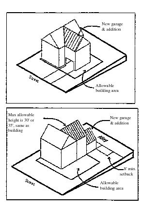
i. The maximum allowable height of a garage, carport or accessory dwelling unit physically attached to a house and totally within the normal buildable area is the maximum allowable height of the underlying zone.
ii. The rear setback may be reduced to eight feet when the building height in the reduced setback area does not exceed sixteen feet in height. When an accessory dwelling unit is located above the attached garage or carport with automobile access from an alley, no portion of the accessory dwelling unit may be located in the reduced setback area.
b. Detached Garages, Accessory Dwelling Units and Carports.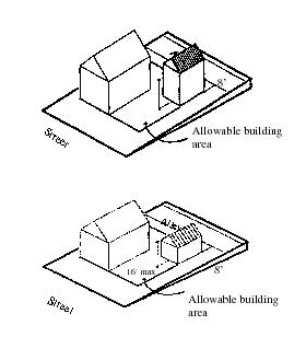
i. The maximum building height of detached garages, accessory dwelling units and carports constructed within the normal buildable area of a lot is the maximum allowable height of the underlying zone, except accessory dwelling units must also conform to the building height requirements under Chapter 17.30.
ii. When the maximum height of detached garages and carports (but not accessory dwelling units) is reduced to sixteen feet they may be located in the rear setback area within:
(A) Eight feet of the rear lot line if the rear lot line abuts an alley; or
(B) Five feet of the rear lot line if adjacent to a single-family residential lot.
iii. All detached garages and carports shall be designed with a pitched roof.
iv. Detached garages, carports and accessory dwelling units designed with more than one story shall conform to the development and design standards for structure exterior standards for accessory dwelling units under Section 17.30.060(B).
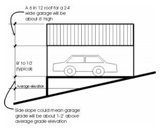
v. Detached garages shall be designed as a one-story building if located on a lot in the area between the front property line and twenty feet behind the front facade of the principal dwelling unit.
vi. Temporary structures which use plastic, canvas, tarps, or other similar materials to cover storage areas, and/or to be used as garages or carports, are prohibited in single-family residential zones.
c. Accessory Buildings.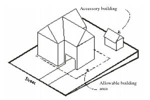
i. The maximum building height of accessory buildings within the normal buildable area of a lot is the maximum allowable height of the underlying zone.
ii. When the maximum height is reduced to sixteen feet, the accessory building may be located in the normal setback area within:
(A) Eight feet of the rear and side lot lines if abutting an alley;
(B) Five feet of the rear and side lot lines if adjacent to a single-family residential lot.
iii. When the maximum height of the accessory building is reduced to twelve feet in height and its building footprint area is less than or equal to one hundred twenty square feet, it may be located anywhere on the lot up to and adjacent to a side or rear lot line.
iv. Accessory buildings over one hundred twenty square feet must be located within the buildable area of the underlying zone.
v. No more than one accessory building less than one hundred twenty square feet may be located within five feet of the rear and/or side lot line.
vi. All accessory buildings shall be designed with a pitched roof.
vii. If designed with more than one story it shall conform to the development and design standards for structure exterior standards for accessory dwelling units under Section 17.30.060(B).
viii. Temporary structures which use plastic, canvas, tarps, or other similar materials to cover storage areas, and/or to be used as garages or carports, are prohibited in single-family residential zones.
19. For the setback requirements next to critical slope areas, refer to MMC 17.52A.050.
20. Where two or more lots are to be developed as a single, unified development site, whether such development is to be accomplished at one time or in phases, no setback shall be required from any lot line that solely abuts upon another lot within the same development site. Setbacks are required only from lot lines on the perimeter of the single, unified development site. Also, maximum lot coverage shall be calculated for the entire single, unified development site and not on an individual lot basis. As used herein, a “single, unified development site” is defined as a lot or combination of lots on which one or more public buildings or other structures will be built or used as an integrated development, such as a municipal campus or other clustering of public uses.
21. Relating to “side,” “interior” and “rear” setbacks, the setback is twenty-five feet from any lot line abutting a residential zone, and zero feet from any lot line abutting any other zone.
22. Lot coverage calculations in the public, semi-public zoning district includes only above-ground structures and does not apply to below-ground structures such as underground parking.
23. In the LI zone the maximum building height shall be sixty-five feet, except for buildings within three hundred fifty feet of the SR-525, Beverly Park Road and 132nd Street SW rights-of-way the maximum building height shall be fifty feet.
24. Private road, common driveway and drive aisle setbacks shall be measured from the centerline of the roadway. The required setback, as measured by the shortest line perpendicular to the front of the garage to the centerline of the roadway is:
a. The stated distance in Table 2: Structure Bulk Matrix; plus
b. One-half of the minimum required width of the roadway.
Measuring Garage Setback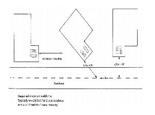
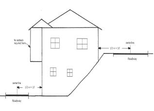
25. The drive aisle setback in Table 2: Structure Bulk Matrix shall only apply to multifamily structures and mixed-use structures with residential dwelling units.
a. The drive aisle setback for habitable areas only applies to the portion of the structure on the same level as a drive aisle.
Habitable Area Setback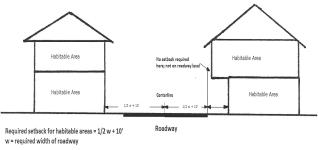
b. If parking outside of a garage is prohibited in and adjacent to the drive aisle except in a designated parking space, the following private garages do not require a drive aisle setback:
i. Garages integrated into a parking lot design in a manner that they meet all parking lot standards and requirements (that is, the garage is essentially a parking space with a roof, walls and/or a door); or
ii. Garages that occupy the entire footprint of one level of a dwelling unit.
c. Drive aisle setbacks do not apply to parking garages which provide parking for more than one dwelling unit.
26. All structures shall have a majority of their front facade built up to the front and corner property lines unless:
a. An option provided for in Chapter 17.25A, Design Standards for the DB District, is used that requires the structure to be located off of the property lines to allow for outdoor seating, small item display areas, or additional pedestrian circulation; or
b. How adjacent property has been developed makes it undesirable to build on the property line near the adjacent property; or
c. Doing so is shown to be unfeasible. (Ord. 1302 §§ 6 (Exh. B), 7, 2012; Ord. 1287 §§5—7, 2012; Ord. 1228 § 3 (Exh. B), 2009; Ord. 1219 § 4 (Exh. D), 2009; Ord. 1210 § 1, 2009; amended during August 2008 supplement; Ord. 1196 § 3 (part), 2008; Ord. 1173 § 7, 2007; Ord. 1128 § 1, 2005; Ord. 1054 § 1, 2002; Ord. 987 §§ 12, 13, 2000; Ord. 1007 §§ 3, 4, 1999; Ord. 990 §§ 3, 4, 1999; Ord. 970 §§ 4, 5, 1998; Ord. 949 §§ 3, 6, 7, 1998; Ord. 948 §§ 11—13, 1999; Ord. 946 § 4, 1998; Ord. 908 § 8 (part), 1997. Formerly § 17.20.020(B))
17.20.028 Maximum hard surface coverage matrix.
The hard surface coverage matrix limits the amount of allowable hard surface coverage based on lot size for single-family residential lots, and based on use type for all other lot use types, according to Table 3.
|
Use Type |
Lot Area Threshold |
Maximum Hard Surface Coverage per Lot* |
|---|---|---|
|
Single-family residential |
≤ 5,999 square feet |
3,000 square feet |
|
6,000—8,399 square feet |
3,780 square feet |
|
|
8,400—9,599 square feet |
3,840 square feet |
|
|
9,600—12,499 square feet |
4,375 square feet |
|
|
≥ 12,500 square feet |
55% of lot area |
|
|
Multifamily including townhouses |
Not applicable |
80% of lot area |
|
Mixed use |
Not applicable |
90% of lot area |
|
Commercial |
Not applicable |
90% of lot area |
|
Industrial |
Not applicable |
95% of lot area |
|
Downtown business and tank farm district |
Not applicable |
100% of lot area |
* Hard surfaces legally established on a site prior to December 31, 2016, and which exceed the limits set forth in this title shall not be considered nonconforming. Proposals to increase the hard surface on a site shall conform to the limits of this title; where a site already exceeds the allowed amount of hard surface, the additional hard surface shall not be approved unless an equal amount of existing hard surface is removed such that the net amount of hard surface is unchanged.
(Ord. 1390 § 5 (Exh. C) (part), 2016)
17.20.030 Pipestem lots.
Pipestem lots shall be allowed subject to the following additional requirements:
A. Minimum street lot frontage of twenty feet;
B. Maximum length of one hundred fifty feet;
C. Area calculations are determined at the minimum lot width line;
D. Minimum height clearance of twelve feet;
E. Allowed on no more than two lots for every fifteen lots of subdivided property;
F. Allowed in cul-de-sacs or where topography does not allow the normal frontage required by the underlying zone; and
G. Allowed only if necessary to maintain the integrity and quality of the proposed development. (Ord. 908 § 8 (part), 1997)
17.20.040 Reducing lot area.
No minimum lot area shall be so reduced or diminished that the setbacks or other open spaces shall be smaller than prescribed by this title, nor shall the density of population be increased in any manner except in conformity with the regulations established by this title. Government structures and facilities shall have no minimum lot area. (Ord. 908 § 8 (part), 1997)
17.20.050 Lot size averaging.
In formal subdivisions approved subsequent to the effective date of the ordinance codified in this section, and where the zoning is RD 20.0, RD 12.5(S), RD 9.6(S), RD 8.4, RD 7.2 or WFB, the minimum lot area of the zone in which the subdivision is located shall be deemed to have been met if the area in lots plus area dedicated for permanent and generally usable common open space or recreational uses, if any, divided by the total number of lots is not less than the minimum lot area of the zone in which the property located; provided, that:
A. This section shall apply within zones having a minimum lot area requirement of twelve thousand five hundred square feet or less;
B. In no event shall any single lot be less than six thousand square feet in area;
C. Not more than a twenty-five percent increase over required minimum lot area for any single lot shall be credited in computing average lot area;
D. Lots with less than the prescribed minimum lot area for the zone in which located shall have a minimum lot width of not less than thirty feet;
E. Preliminary plats approved utilizing lot averaging shall not be recorded by divisions unless such divisions individually or together as cumulative, contiguous parcels, satisfy the requirements of this section. (Ord. 908 § 8 (part), 1997)
17.20.060 Sight distance triangle.
Upon the effective date of the ordinance amending this section (May 16, 2001), no structures, fences, or freestanding walls shall be built as to obstruct the visibility at an intersecting street. In addition, for public safety reasons vegetation shall not be allowed to grow to a height or width which could obstruct visibility at an intersection. Unobstructed visibility at corners is measured according to the following diagrams.
A. Single-Family Residential Properties. Unobstructed vision at corners for all fences, freestanding walls, and hedges shall be measured in accordance with the following sight distance triangle:
1. Where posted speed on both streets is twenty-five miles per hour or less; and
2. No stop signs or other traffic control features are present on either streets.
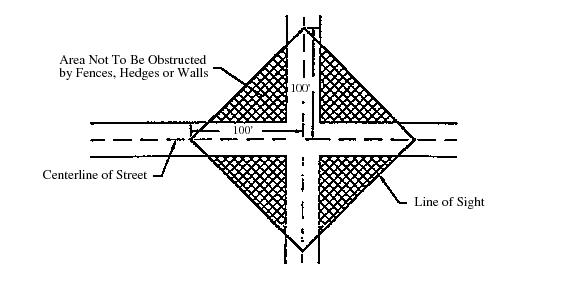
Diagram A
Single-Family Residential Sight Distance Triangle
B. Properties Adjacent to a Controlled Intersection. Properties adjacent to a controlled intersection shall be designed to maintain unobstructed vision at intersections in accordance wit the following standards:
1. Unobstructed sight distances shall be designed according to the following speed limit schedule:
|
Posted Speed Limit (on the public r-o-w) |
25 mph |
30 mph |
35 mph |
40 mph |
|
Sight Distance |
300′ |
400′ |
530′ |
600′ |
2. These distances are required for an approaching vehicle to be able to reduce speed or stop in order to prevent a collision.
3. For road approaches where left turns are not allowed, a sight triangle need only be provided to the left, as shown.
4. For road approaches where left turns are allowed, provide a sight triangle to the right in addition to the one to the left. The sight distance to the right is measured along the centerline of the roadway.
5. Sight distance numbers are for passenger vehicles only. If there are a significant number of trucks, greater than ten percent of ADTs (average daily trips), using the intersection, then the sight distance shall be increased in accordance with the AASHTO requirements as determined by the public works director.
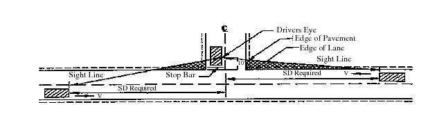
Diagram B
Sight Distance at Controlled Intersections
(Ord. 1026 § 3, 2001: Ord. 908 § 8 (part), 1997)
17.20.070 Setbacks for certain uses.
A. Agriculture. All structures used primarily or exclusively for housing or feeding animals, not including dog houses, shall be located at least thirty-five feet from all property lines and dwellings, with the exception of horse paddocks, chicken coops, pigeon and dove shelters and rabbit hutches, which shall be located at least fifteen feet from all property lines and twenty-five feet from a dwelling unit located on adjacent lots. The setback for a horse shelter building may be reduced to ten feet if the lot on which it is located is less than one acre in area and if the property has a farm management plan approved by the Snohomish Conservation District.
B. Amusement Facilities. Theaters must be at least three hundred feet from the property line of any preschool or K-12 school. Other amusement facilities must be at least five hundred feet from the property line of any park, playground, preschool, or K-12 school. Distances in such cases shall be measured along street margins to find the shortest travel route.
C. Art Gallery. All buildings must be at least twenty feet from any other lot in a residential zone.
D. Cemetery, Columbarium and Mausoleum. All buildings must be at least fifty feet from external boundaries of the property.
E. Church. All buildings must be at least twenty-five feet from any other lot in a residential zone.
F. Dock and Boathouse. Covered structures must be at least five feet from any side lot line or extension thereof. No setback from adjacent properties is required for any uncovered structure, and no setback from the water is required for any structure permitted hereunder.
G. Governmental Structure or Facility. All structures must be at least twenty feet from any other lot in a residential zone.
H. Hospital. All buildings must be at least thirty feet from all external property boundaries.
I. Library. All buildings must be at least twenty feet from any other lot in a residential zone.
J. Mini-Self Storage. Separation between buildings shall be a minimum of twenty-five feet, within which parallel parking and loading areas shall be provided.
K. Museum. All buildings must be at least twenty feet from any other lot in a residential zone.
L. Nursing Home. All buildings must be at least thirty feet from all external property boundaries.
M. Riding Academy. Stables must be at least thirty feet from any external property line.
N. School—Preschool and K-12.
1. All buildings must be at least thirty-five feet from all external property lines; and
2. All buildings must be at least seventy-five feet from the centerlines of all street right-of-way, or forty-five feet from the edges of all such right-of-way, whichever is greater.
O. Schools, Other.
1. All buildings must be at least thirty-five feet from all external property lines; and
2. All buildings must be at least thirty-five feet from the centerlines of all street right-of-way, or forty-five feet from the edges of all such right-of-way, whichever is greater.
P. Service Station.
1. Pump Islands. Where the right-of-way is less than sixty feet, pump islands shall meet a minimum setback of forty-five feet from the centerline of the right-of-way. Where the right-of-way is sixty feet or more, pump islands shall meet a minimum setback of one-half the right-of-way plus fifteen feet. Setbacks shall apply to private right-of-way and easements.
2. Canopies. Where the right-of-way is less than sixty feet canopies shall meet a minimum setback of thirty-five feet from the centerline of the right-of-way. Where the right-of-way is sixty feet or more, canopies shall meet a minimum setback of one-half the right-of-way plus five feet. Setbacks shall apply to private right-of-way and easements.
Q. Swimming or Wading Pool. The pool must be at least seven feet from any property line.
R. Tavern. The use must be at least five hundred feet from the external property lines of all public school grounds and public parks or playgrounds.
S. Utility Structures. All structures must be at least twenty feet from any other lot in a residential zone.
T. Storage Structure Over One Thousand Square Feet on Less Than Three Acres. The building must be at least fifteen feet from any external property line. The planning director may require additional setback distances if the bulk (height, length and width) of the storage structure would be out of scale with the bulk of an adjacent structure or structures on adjoining properties. (Ord. 1288 § 4, 2011; Ord. 1107 § 3, 2004; Ord. 908 § 8 (part), 1997)
17.20.080 Fences and freestanding walls.
A. Fences and Freestanding Walls. Fences and freestanding walls are allowed under the following conditions.
1. Materials.
a. Fences and freestanding walls in all commercial and residential zones shall be constructed of suitable materials except barbed or concertina wire, and may not be electrified.
b. Barbed wire fencing is allowed in industrial zones so long as the barbed wire is positioned in such a way that it leans inward towards the enclosed area.
2. Height.
a. In residential zones, fences and freestanding walls located in side and rear yards may not exceed six feet in height and must be stepped down to not more than four feet or forty-eight inches at the front setback line. Decorative features, artwork, or trellises may be allowed on a fence as long as the features do not add additional screening or opaqueness which in effect increases the height of the fence.
b. In commercial and industrial zones, fences and freestanding walls may not exceed eight feet in height and may not obstruct the vision of an intersecting street. Unobstructed vision at corners is measured according to the sight distance triangle requirement diagram shown in Section 17.20.060.
c. Fences around schools and utility substations may not exceed eight feet in height, except as allowed under the administrative modification section or with an approved conditional use permit, and may not obstruct the visions of an intersecting street. Unobstructed vision at corners is measured according to the sight distance triangle requirement diagram shown in Section 17.20.060.
d. For purposes of measuring fence and freestanding wall height, the height shall be measured from the lowest point of the fence touching the ground to the highest point on either side of the fence. If a fence is placed upon a rockery or retaining wall, the fence must be set back a minimum of two feet, or the height of the fence and rockery/retaining wall combined will be used to measure the overall height of the fence or freestanding wall.
3. Placement. For safety reasons, fences and freestanding walls on corner lots may not be constructed of any material or built to a height which would obstruct vision of an intersecting street. Unobstructed vision at corners is measured according to the sight distance triangle requirement diagram shown in Section 17.20.060.
B. Administrative Modifications. If the strict application of this section would restrict reasonable screening of a person’s property, the planning director or his/her designee may allow deviations from this section under the following conditions and criteria:
1. The applicant shall submit a written statement, site plan, and elevation drawings describing the proposal and why the deviation is necessary.
2. The adjoining property owners shall be notified of the requested modification and given fourteen calendar days to comment on the proposal.
3. When reviewing the modification request, the planning director or his/her designee must find that the following criteria has been met:
a. Fences or freestanding walls may not be increased by more than two feet in height;
b. Sight distance vision of an intersecting street may not be obstructed. Unobstructed vision at corners is measured according to the sight distance triangle diagram shown in Section 17.20.060;
c. The deviation must be necessary because of special circumstances relating to the topography, location, or surroundings of the subject property; and
d. The deviation is not objectionable to adjacent property owners.
C. Variances. Increases in the height of fences or freestanding walls by more than two feet in height shall be subject to the review procedures and requirements of Section 17.64.040, Variances. (Ord. 1034 § 2, 2001: Ord. 1026 § 1, 2001: Ord. 908 § 8 (part), 1997)
17.20.083 Hedges.
For safety reasons, trees, hedges, and/or vegetation shall not be allowed to grow to a height or width which would obstruct vision at intersecting streets. Unobstructed vision at corners is measured according to the sight distance triangle diagram shown in Section 17.20.060. (Ord. 1026 § 2, 2001)
17.20.085 Development agreements.
A. Development Agreements. The city council may approve, for any parcel within the city, a development agreement which contains project elements, a vesting period, and establishes or modifies the development standards on a site-specific basis, including but not limited to density, parking, streets, setbacks, building separation, landscaping and other standards, pursuant to the procedures of RCW 36.70B.170 through 36.70B.210.
Development agreements may not deviate from the permitted uses as allowed in each of the above referenced zones and as contained in Section 17.16.040.
B. Procedure—Community Meeting. Within thirty days of the notice of application a community meeting shall be held to obtain public comments on the proposed development agreement. The purpose of the meeting is to identify issues, concerns and/or constraints which may affect the project and surrounding community. The community meeting is not intended to be part of the official record of the application. At a minimum the development agreement shall include:
1. An outline of the agreement;
2. Bubble diagram showing proposed uses and access;
3. List of permitted uses and issues.
C. Community Meetings. For projects that will include a development agreement, the following notice and comment periods apply:
1. The notice of application shall include the date, time and place for the community meeting.
2. Written comments regarding the development agreement may be submitted before the community meeting, at the community meeting, or within fourteen days after the community meeting.
D. Final Decision. Consideration and a decision on the final draft of the development agreement shall be done after a public hearing but prior to the final decision on the related project. (Ord. 1193 § 1, 2008: Ord. 956 § 4, 1998)
17.20.090 Additional development regulations for the MRD zone.
A. In the MRD zone the minimum outdoor active or passive recreation area shall be three hundred fifty square feet per dwelling unit for the overall site, exclusive of required landscaping or setbacks. Where the development is within three hundred feet of a developed park, this requirement may be in private open space. A minimum of fifty square feet shall be in private open space.
B. Screening. Where adjacent to a single-family residential zone, a sight-obscuring fence or vegetative screen shall be required in accordance with the landscaping matrix contained in Section 17.58.047. Vegetative screens are to be kept free of weeds and debris, and the vegetation is to be maintained in a healthy condition. Vegetative screens shall not be allowed to grow to a height or width which would obstruct vision of an intersecting street as defined in Section 17.20.060. Vegetative screening areas shall preserve existing native vegetation to the extent feasible, or be comprised of native species where feasible. (Ord. 1390 § 5 (Exh. C) (part), 2016; Ord. 1026 § 4, 2001; Ord. 908 § 8 (part), 1997)
17.20.110 Additional development regulations for the PCB district.
A. Development upon any property within the PCB district shall proceed in accordance with a project permit application as provided in Chapter 17.13. Approval is based upon data submitted by the applicant, including but not limited to the project sponsor presenting evidence of their ability to meet the following performance standards:
1. Storage. All storage of materials shall occur within enclosed structures, except that waste receptacles may be located outdoors within an area screened by a sight-obscuring fence.
2. Environmental and Residential Compatibility. Building and site features shall be designed and arranged with sensitivity toward adjacent residential areas. Views from residential areas shall not be obstructed by more than twenty percent by buildings or other site features.
3. Traffic and Access. Access driveways and roads entering and exiting the project site shall be consolidated so as to minimize intersections with city streets. Wherever possible, there shall be one entry/exit driveway for every street frontage. Ingress and egress to the site shall be located so as to cause the least disruption to adjacent residential areas and safe, convenient traffic flow. Roads serving the site shall be improved to city street standards for the entire property frontage.
4. View. All buildings within the PCB district which are located adjacent to view corridors or other scenic vistas shall be designed and constructed in such a manner that each floor provides the following amount of horizontal and vertical space open to public access and open to the appropriate vistas:
a. First floor, twenty percent of lot width;
b. Above first floor, twenty-five percent of lot width; and
c. Structures adjacent to scenic vistas shall not extend for more than one hundred lineal feet at the first floor without being interrupted by a space at least ten feet in width that is open to view.
B. No clearing or grading activity shall occur on the property prior to issuance of construction permits. (Ord. 908 § 8 (part), 1997)
17.20.120 Additional development regulations for the PCB(S), BP and IP zones.
A. Each project permit application submitted in the PCB(S), BP, and IP zones, shall comply with the following requirements:
1. Processes and Equipment. Processes and equipment employed and goods processed or sold shall be limited to those which are not objectionable beyond the boundaries of the lot upon which the use is located by reason of offensive odors, dust, smoke, gas or electronic interference.
2. Development Phases. Where the proposal contains more than one phase, all development shall occur in a sequence consistent with the phasing plan which shall be presented as an element of the preliminary plan unless modification is approved by the planning director.
3. Building Design. Buildings shall be designed to be compatible with their surroundings, both within and adjacent to the zone.
4. Restrictive Covenants. Restrictive covenants shall be provided which shall ensure the long-term maintenance and upkeep of landscaping, storm drainage facilities, other private property improvements, and open space areas and facilities. Further, said covenants shall reference the binding site development plans and indicate their availability at the planning department, and shall provide that the city is an additional beneficiary with standing to enforce, and shall preclude the avoidance of performance obligations through lease agreements.
5. Noise. Noise levels generated within the development shall not exceed those established in Title 18, Land Use Enforcement, or violate other law or regulation relating to noise. Noise of machines and operations shall be muffled so as to not become objectionable due to intermittence or beat frequency, or shrillness.
B. General Landscaping and Open Space Requirements. These requirements are in addition to those contained in Chapter 17.58.
1. The planning director may require landscaping in combination with berms for noise screening.
2. Where a site has substantial numbers of evergreen trees, site development shall be sensitive to the preservation of such vegetation.
3. Except where specifically prohibited, the planning director, concurrently with action on the final BP or IP plan, may waive or modify landscaping requirements abutting residential zones and between right-of-way or private access roads and buildings and parking areas where abutting residential uses will not be adversely affected, and where existing physical improvements, physiographic features or imminent changes in abutting land uses will render full compliance with said requirements ineffective. If said requirements are waived, or width of the buffer reduced, the planning director shall establish the minimum side and rear yard building setbacks from residentially designated property.
4. Areas zoned PCB(S) shall include a minimum of fifteen percent of the site area for common open space. Open space shall not include areas devoted to buildings, parking or vehicular access.
5. Areas zoned BP, in addition to required landscaping, a minimum of ten percent of the balance of the site shall be landscaped. Landscaping required for parking and outdoor display areas may serve to fulfill a portion of this requirement.
C. PCB(S) Zone Requirements. In addition to the requirements contained above, the following are specific performance requirements in the PCB(S) zone:
1. All uses permitted in this zone shall be entirely contained within an enclosed structure except the following:
a. Public utility transmission facilities;
b. Eating establishments where the space for outdoor public service is adjacent to the closed structure and does not disrupt vehicular traffic within or adjacent to the zone;
c. Permitted signing;
d. Parking and loading facilities;
e. Plant nurseries; and
f. Outdoor storage area, when in conjunction with an enclosed principal use.
2. No outside loading and unloading of goods and materials shall occur between the hours of ten p.m. and seven a.m. where nuisances would result to adjoining properties.
D. BP Zone Requirements. In addition to the requirements contained above, the following are specific performance requirements in the BP zone:
1. No uncovered outside storage shall be allowed of any products produced or items used in the operation of the business, except vehicles used to transport either raw materials or finished products of the business.
2. Not more than twenty percent of the constructed BP zone floor area in any such development may be devoted to those accessory retail commercial uses primarily intended to serve the principal BP zone uses.
3. The retail sale of products manufactured on the BP zone site shall be permitted.
4. Prior to the issuance of any building occupancy permits in a BP zone the developer(s) shall either complete all required improvements of a public nature, such as but not limited to streets, sidewalks, storm runoff and erosion control system, street signs and streetlights, to the required specification, or enter into an agreement with the city to construct such development as may be approved, together with performance bond or other suitable collateral to ensure the completion of such improvements. Required improvements of a private nature, such as but not limited to private roads and landscaping, shall be constructed prior to building occupancy, bonded, or subject to city approval, be constructed in conformance with a performance schedule delineated as part of the final plan which shall be tied to the issuance of building, occupancy or other permits. All bonded improvements shall be completed within six months of bond issuance or be subject to bond forfeiture. Bond extensions may be granted by the public works director. As improvements are completed and upon application by the developer, a partial release of the bond or collateral may be authorized which will leave a balance equal to the cost of completing the remaining improvements as certified by the city. The bond or collateral agreement shall provide for forfeiture to the city and the right to withdraw funds upon default by the developer to construct any or all of the public improvements in accordance with approved specifications within the time limited for performance. The bond may be issued for phased divisions of the development as may be approved by the city.
5. All outdoor lighting shall conform to the unified architectural lighting scheme for the BP development and shall not:
a. Shine on adjacent properties;
b. Conflict with the readability of traffic control devices; or
c. Rotate or flash. (Ord. 908 § 8 (part), 1997)
17.20.130 Additional development regulations for the PI zone.
A. Development upon any property within the PI district shall proceed in accordance with a project permit application as provided in Chapter 17.13. Approval is based upon data submitted by the applicant, including but not limited to the project sponsor presenting evidence of their ability to meet the following performance standards:
1. Outside Storage. All storage of materials and finished products shall either be completely enclosed or surrounded by a sight-obscuring barrier of at least six feet. Barriers may consist of buildings, fences, landscaping or other means such that outdoor storage areas are not visible from adjacent residential areas.
2. Environmental Compatibility. Uses within the PI zone shall not produce objectionable odors, noises, dust, smoke, light, glare or electronic interference beyond property boundaries.
3. Residential Compatibility. Buildings and site features shall be designed and arranged with sensitivity toward adjacent residential areas.
4. Traffic and Access. Ingress and egress to the site shall be located as to cause the least disruption to adjacent residential areas. Roads serving the site shall be improved to city street standards as required by the public works director.
B. No clearing or grading activity shall occur on the property prior to issuance of construction permits. (Ord. 908 § 8 (part), 1997)
17.20.140 Additional development regulations for the PSP district.
A. Before a building permit is issued for any new structure or any addition to an existing building, or for the establishment of a use not involving a building, which does not require a conditional use permit, a site development plan shall be approved by the city council as complying with the intent and purpose of the PSP district, as well as all other applicable city ordinances. The plan shall be evaluated particularly with respect to the location, height and orientation of buildings on the lot; the orientation of wall openings above the second floor in relation to residential homesites, developed or undeveloped; and the preservation of the character of adjoining residential neighborhoods. The city council shall approve the site plan, specify additional information, or require changes to be made in the site plan in order for it to be approved. After the site plan has been approved, no building permit may be issued for any building which is not in compliance with the approved site plan. The approved site plan may be amended in the same manner required for the original approval. The city may require a preliminary site development plan prior to considering the rezoning of land to the PSP district, and if such a site plan is required, the final site development plan shall be in general conformance with the preliminary plan.
B. Uses which require a conditional use permit shall be considered by permit authority as identified in Chapter 17.13, Project Permit Review Procedures, and should approval be granted, need not be reviewed by the city council. (Ord. 1088 § 12, 2003: Ord. 908 § 8 (part), 1997)
17.20.150 Additional development regulations for the WMU district.
A. Commercial uses shall comply with the following:
1. All the uses shall be contained within an entirely closed structure with the exception of, eating establishments wherein outdoor eating space does not obstruct vehicular movement, parking, and ferry loading facilities.
2. Commercial uses located north of the Burlington Northern Santa Fe (BNSF) railroad tracks shall not be so located as to obstruct or impede pedestrian access of beach areas at low tide waters as established by the mean low tide mark.
3. Marine fuel, oil and other petroleum product storage must occur landward of the ordinary high water mark. Pumping or distribution of marine fuel, oil or other petroleum products may occur on a pier facility; providing such a pier is firmly attached to the piling; and provided, that the facility is part of a marine/marina complex.
B. Park uses are subject to the following:
1. All the uses and facilities shall be located, constructed or developed in accordance with the master/site plan approved by city council.
2. All proposals for park and recreation facilities shall be accompanied by an adopted master or site plan which is drawn to scale and shows the location of all park activities, recreational facilities, utilities, parking areas, structures, points or ingress and egress, vehicular and pedestrian circulation features, existing and proposed vegetation as may be a part of and necessary to describe the proposal.
3. All proposals for park and recreation facilities shall be designed and constructed in conformance with the overall plan for the waterfront as contained in the comprehensive plan and the multi-modal plan.
C. Boating/marina facilities shall comply with the following:
1. Marine facilities shall be designed and constructed in conformance with the policies and regulations contained in the city’s shoreline master program. Marine facilities shall conform to height limitations contained in the shoreline master program and waterfront zone, and structures shall be limited to office, restroom, waste disposal and fueling facilities.
2. Boat maintenance activities shall only include routine repairs done by boat owners to keep their own boats in good repair.
3. Boat launching may occur in conjunction with a marina development. A four-lane public boat ramp for motorized boats may be developed if it replaces the public boat ramp presently at the Mukilteo State Park, and there are enough double length parking stalls to accommodate forty vehicles per launch lane (one hundred sixty double length parking stalls).
4. A car-top, nonmotorized boat launch is permissible from designated beaches or car-top launch facilities.
D. Transportation facilities shall comply with the following:
1. Any ferry launch facility, terminal building or vehicle holding area must be designed and located in accordance with the city’s waterfront master design or multi-modal plans and any development in the waterfront area must be approved by the city through an administrative design review process. The ferry and commuter rail facilities, and multi-modal station shall include public restrooms, sheltered passenger waiting areas and covered platforms that also provide adequate protection along the sides, and shall incorporate interior and exterior public art. (Ord. 948 § 15, 1999)