


Chapter 17B.08
DEFINITIONS
Sections:
17B.08.010 General.
For the purposes of this title and to clarify the intent and meaning of certain words or terms, the following list of definitions is provided. All other words used in this title carry their customary meaning as defined in the Webster’s dictionary. Words in the present tense include the future tense, and words in the singular tense include the plural and vice versa. (Ord. 1427 § 3 (Exh. C) (part), 2019: Ord. 1295 § 10 (Exh. 1B) (part), 2011)
17B.08.020 Definitions.
“Act” means the Washington State Shoreline Management Act, Chapter 90.58 RCW.
“Adoption by rule” means an official action by the department to make a local government shoreline master program effective through rule consistent with the requirements of the Administrative Procedures Act, Chapter 34.05 RCW, thereby incorporating the adopted shoreline master program or amendment into the state master program.
“Amendment” means a revision, update, addition, deletion, and/or reenactment to an existing shoreline master program.
“Aquaculture” means the culture or farming of fish, shellfish, or other aquatic plants and animals. “Aquaculture” does not include the harvest of wild geoduck associated with the state managed wildstock geoduck fishery.
“Archaeological/historical” means uses, developments, and activities on sites of historical or archeological significance, or sites containing items of historical or archeological significance.
“Best available science” means current scientific information used in the process to designate, protect, or restore critical areas, that is derived from a valid scientific process as defined by WAC 356-195-900 through 356-195-925. Sources of best available science are included in Citations of Recommended Sources of Best Available Science for Designating and Protecting Critical Areas published by the Washington State Department of Commerce. The term “best available science” as used in this title includes the most current, accurate and complete scientific and technical information available as contemplated under WAC 173-26-201(2)(a).
“Biological habitat report” means a report prepared by a qualified biologist that evaluates the potential presence or absence of designated critical fish or wildlife species on a particular parcel of land. A biological habitat report shall contain an assessment of habitats including the following site and proposal related information at a minimum:
1. Detailed description of vegetation and location of the ordinary high water mark (OHWM) on and adjacent to the project area and its associated buffer. The OHWM shall be shown on project drawings and a description of field indicators used to establish the OHWM included in the assessment;
2. Identification of any species of local importance, priority species, or endangered, threatened, sensitive, or candidate species that have a primary association with habitat on or adjacent to the project area, and assessment of potential project impact to the use of the site by the species;
3. A discussion of any federal, state, or local special management recommendations, including Washington Department of Fish and Wildlife habitat management recommendations, that have been developed for species or habitat located on or adjacent to the project area;
4. A detailed discussion of the direct and indirect potential impacts of habitat by the project, including potential impacts to water quality;
5. A discussion of measures, including avoidance, minimization, and mitigation, proposed to preserve existing habitats and restore any habitat that was degraded prior to the current proposed land use activity and to be conducted according to mitigation sequencing; and
6. A discussion of ongoing management practices that will protect habitat after the project site has been developed, included proposed monitoring and maintenance programs.
“Biologist, qualified” means a person who possesses a bachelor’s degree from an accredited college in biology, a branch of biology, limnology, biometrics, oceanography, forestry or natural resource management. A qualified biologist is also a person determined by the city to be qualified based upon that person’s education, professional referrals, related experience, work history, and examples of comparable projects.
“Boat” means vessels less than twenty tons, used as a private pleasure craft.
“Boat launching facility” means a facility used for launching of boats by auto or hand, including ramps and other devices, along with adequate parking and maneuvering space. For the purpose of the chapter, boating facilities exclude docks serving four or fewer single-family residences.
“Boathouse” means a structure specifically designed or used for storage of boats.
“Breakwater” means protective structure usually built off-shore for the purpose of protecting the shoreline or harbor areas from wave action.
“Buffer” means an area, typically adjacent or otherwise associated with an environmentally sensitive feature, which is retained in its natural state. No clearing, grading, or filling is permitted within a buffer (unless specifically conditioned otherwise).
“Buildable area” is that portion of a lot within the setbacks established by the zoning district in which the lot lies. Open space tracts, native growth protection areas, drainage facilities, easements, or other similarly restricted land are not considered part of the buildable portion of a lot.
“Bulkhead” means a wall or embankment used for holding back earth and to protect structures or shoreline from wave action.
“Channel migration zone (CMZ)” means the area along a river within which the channel(s) can be reasonably predicted to migrate over time as a result of natural and normally occurring hydrological and related processes when considered with the characteristics of the river and its surroundings.
Critical Areas. For the purpose of the critical area regulations contained in Chapters 17B.52 through 17B.52D, “critical areas” means those possessing existing slopes in excess of forty percent, or areas containing unstable soils or other geologic hazards, or natural drainage ways or ravines, areas of special flood hazard, areas of critical recharging effect on aquifers used for potable water, or areas that have been identified as providing significant wildlife habitat by the Washington Department of Fish and Wildlife, wetland areas, or those areas defined as shorelines of Mukilteo, the state, or of statewide significance.
“Day-lighting a stream” means to bring a previously culverted or piped stream or stormwater drain to the surface. Day-lighting projects reestablish a stream in its old channel where feasible, or create a new channel if necessary. Day-lighting projects shall include installation of habitat features such as large woody debris, creation/recreation of wetlands, streams, and ponds.
“Department” or “DOE” means the State Department of Ecology.
“Development” means a use consisting of the construction or exterior alteration of structures; dredging; drilling; dumping; filling; removal of any sand, gravel, or minerals; bulk-heading; driving of piling; placing of obstructions; or any project of a permanent or temporary nature which interferes with the normal public use of the surface of the waters overlying lands subject to this title at any state of water level. “Development” does not include dismantling or removing structures if there is no other associated development or redevelopment.
“Development regulations” means the controls placed on development or land uses by a county or city, including, but not limited to, zoning ordinances, critical areas ordinances, all portions of a shoreline master program other than goals and policies approved or adopted under Chapter 90.58 RCW, planned unit development ordinances, subdivision ordinances, and binding site plan ordinances together with any amendment thereto. “Development” does not include dismantling or removing structures if there is no other associated development or redevelopment. A forest practice that only involves timber cutting is not a development under the Act and does not require a shoreline substantial development permit or a shoreline exemption. A forest practice that includes activities other than timber cutting may be a development under the Act and may require a substantial development permit, as required by WAC 222-50-020.
“Dock” means any facility for the moorage of boats, including but not limited to piers, wharves, and quays.
“Dredging” means removal of sand, gravel, or other earth from the bottom of a body of water for the purpose of deepening a navigational channel or obtaining bottom materials. Dredging does not include maintenance sediment removal at pipe inlets or outlets or removal of material from manmade ponds excavated in nonwetland sites, including backwash solids drying areas, or stormwater ponds. Excavation for the purposes of constructing utilities and other permitted structures (e.g., pilings) shall not be considered dredging.
“Drift cell,” “drift sector,” or “littoral cell” means a particular reach of marine shore in which littoral drift may occur without significant interruption and which contains any natural sources of such drift and also accretion of shore forms created by such drift.
“Ecological functions” or “shoreline functions” means the work performed or role played by the physical, chemical, and biological processes that contribute to the maintenance of the aquatic and terrestrial environments that constitute the shoreline’s natural ecosystem. See WAC 173-26-200(2)(c).
“Ecosystem-wide processes” means the suite of naturally occurring physical and geologic processes of erosion, transport, and deposition; and specific chemical processes that shape landforms within a specific shoreline ecosystem and determine both the types of habitat and the associated ecological functions.
“Essential public facility” or “EPF” means a facility that is typically difficult to site, such as an airport, a state education facility, a state or regional transportation facility as defined in RCW 47.06.140, a state or local correctional facility, a solid waste handling facility, or an in-patient facility, including substance abuse facilities, mental health facilities, group homes, and secure community transition facilities as defined in RCW 71.09.020. The term “essential public facility” includes all facilities listed in RCW 36.70A.200, all facilities that appear on the list maintained by the State Office of Financial Management pursuant to RCW 36.70A.200(4), and all facilities listed as essential public facilities in the Mukilteo comprehensive plan.
“Essential public facility, local” means an EPF that is owned, operated, or sponsored by the city of Mukilteo, a special purpose district, Snohomish County (for facilities that do not provide service to the countywide population), or another unit of local government. An EPF is “sponsored” by a local government when it is to be owned or operated by a nongovernmental entity pursuant to a contract with the local government to provide the EPF.
“Essential public facility, regional” means an EPF that is owned, operated, or sponsored by Snohomish County or a regional agency whose boundaries encompass the city and which serves the countywide population or an area that is greater than the county. An EPF is “sponsored” by the county or a regional agency when it is to be owned or operated by a nongovernmental entity pursuant to a contract with the county or regional agency to provide the EPF.
“Essential public facility, state” means an EPF that is owned, operated, or sponsored by the state of Washington.
“Feasible” means, for the purpose of this title, that an action, such as a development project, mitigation, or preservation requirement, meets all of the following conditions:
1. The action can be accomplished with technologies and methods that have been used in the past in similar circumstances, or studies or tests have demonstrated in similar circumstances that such approaches are currently available and likely to achieve the intended results;
2. The action provides a reasonable likelihood of achieving its intended purpose; and
3. The action does not physically preclude achieving the project’s primary intended legal use.
In cases where these guidelines require certain actions unless they are infeasible, the burden of proving infeasibility is on the applicant. In determining an action’s infeasibility, the reviewing agency may weigh the action’s relative public costs and public benefits, considered in the short- and long-term time frames.
“Fill” means the addition of soil, sand, rock, gravel, sediment, earth retaining structure, or other material to an area waterward of the OHWM, in wetlands, or on shorelands in a manner that raises the elevation or creates dry land.
“Floodplain” is synonymous with one-hundred-year floodplain and means that land area susceptible to inundation with a one percent chance of being equaled or exceeded in any given year. The limit of this area shall be based upon flood ordinance regulation maps or a reasonable method which meets the objectives of the Act.
“Floodway” means the area, as identified in a master program, that either: (1) has been established in Federal Emergency Management Agency flood insurance rate maps or floodway maps; or (2) consists of those portions of a river valley lying streamward from the outer limits of a watercourse upon which flood waters are carried during periods of flooding that occur with reasonable regularity, although not necessarily annually, said floodway being identified, under normal condition, by changes in surface soil conditions or changes in types or quality of vegetative groundcover condition, topography, or other indicators of flooding that occurs with reasonable regularity, although not necessarily annually. Regardless of the method used to identify the floodway, the floodway shall not include those lands that can reasonably be expected to be protected from flood waters by flood control devices maintained by or maintained under license from the federal government, the state, or a political subdivision of the state.
“Forestry” means the art and science of managing forests, tree plantations, and related natural resources. The main goal of forestry is to create and implement systems that allow forests to continue a sustainable continuation of environmental supplies and services. The city does not have any forest lands, as regulated by the Shoreline Management Act, that are not already characterized by urban growth and that have long-term significance for the commercial production of timber. However, clearing of land within the two-hundred-foot shoreline jurisdiction may require a forest practice permit.
“Forest practice permit” means a permit which is required for the removal of five thousand board feet or more of merchantable timber. Class IV—General forest practice permits are administered by the Department of Natural Resources. This permit is often approved as an adjunct to another development permit such as a building permit or residential subdivision.
“Geotechnical report” means a report, prepared by a licensed professional (either an engineering geologist or civil engineer specializing in geotechnical engineering and local shoreline geology and processes) legally able to practice in the state of Washington, shall include an assessment of the geologic characteristics of the soils, sediments, and/or rock of the project area and potentially affected adjacent properties, and a review of the site history regarding landslides, erosion, and prior grading. Soils analysis shall be accomplished in accordance with accepted classification systems in use in the region. The assessment shall include, but not be limited to:
1. Data regarding underlying geology, slope gradients, soil types, and subsurface information including boring and/or test pit logs describing soil stratification, and results of soil tests conducted.
2. Identify any previous landslide activity in the vicinity of the project and provide an assessment of the overall slope stability and the effect the development will have on the slope, adjacent properties, and shoreline over time.
3. Recommendations for grading procedures, fill placement and compaction criteria, temporary and permanent slope inclinations and support, and design criteria for corrective measures and opinions and recommendations regarding the capabilities of the site.
4. The report shall consider seismic stability of the site in drained and saturated conditions. The geotechnical report shall include a statement that the design criteria consider a seismic event with a ten percent probability of being exceeded in fifty years.
5. Potential for liquefaction and proposed mitigation measures.
6. A description of the hydrology (both surface and subsurface) of the site, including locating any wetland, streams, springs, seeps, groundwater, and shorelines along with recommendations consistent with the city’s shoreline critical area regulations for addressing any impacts.
7. The report shall make a recommendation on building site location, foundation type and depths, minimum building setbacks, minimum deck and accessory building setbacks, and if necessary the minimum no-disturbance buffer from any geologic sensitive area based upon the geotechnical analysis. The report shall also include recommendations on the design of soft or hard stabilization structures in the shoreline area. Only if there is a threat to an existing structure that cannot be controlled by soft armoring methods may hard structures be used in accordance with Section 17B.18.060, Shoreline stabilization.
8. An estimate of bluff retreat rate that recognizes and reflects potential catastrophic events such as seismic activity or one-hundred-year storm event.
9. Assessment of potential impacts created by a tsunami if applicable.
10. Recommendations and requirements for handling contaminated soils and materials if encountered on the site.
“Grading” means the movement or redistribution of the soil, rock, gravel, sediment, or other material on a site in a manner that alters the natural contour of the land.
“Groin” means a barrier-type structure extending from the back of shore into the water across the beach. The purpose of a groin is to interrupt sediment movement along the shore.
Habitat Report. See “Biological habitat report.”
“Hearing Board” means the Shoreline Hearings Board (not the Growth Management Hearing Board(s)).
“In-water facilities” means boat-launching facilities, marinas, visitor docks, mooring buoys, residential docks, floats, seaplane access and moorage, docking facilities for cruise boats, and waterborne transportation facilities.
“In-water fill” means activities that involve the addition of soil, sand, rock, gravel, earth retaining structure, or other material to an area waterward of the ordinary high water mark or in shorelands in a manner that raises the elevation or creates dry land.
“Jetty” means an artificial barrier used to change the natural littoral drift to protect inlet entrances from clogging by excessive sediment.
“Long-term transient residential uses” means transient rentals and/or renting out a property for periods of less than thirty days and is considered a commercial activity according to the state Department of Revenue. Such uses are prohibited by the Permitted Use Matrix listed in Chapter 17B.16.
“Marina” means a facility providing for the rental or public use of moorage for pleasure craft and which may include accessory facilities such as sales, rentals, and light servicing of these craft.
“Marine” means pertaining to tidally influenced waters, including oceans, sounds, straits, marine channels, and estuaries, including the Pacific Ocean, Puget Sound, Straits of Georgia and Juan de Fuca, and the bays, estuaries and inlets associated therewith.
“May” means the action is acceptable, provided it conforms to the provisions of this title.
“Moorage” means any device or structure used to secure a vessel for temporary anchorage, but which is not attached to the vessel (such as a pier or buoy).
“Mukilteo’s MUGA or municipal urban growth area” is that portion of Snohomish County’s southwest urban growth area that is being considered by the city of Mukilteo for future annexation and has been mutually agreed to by all surrounding cities through the Snohomish County Tomorrow process.
“Must” means a mandate; the action is required.
“No net loss—shorelines” means that while certain uses and development are appropriate and necessary and must be provided for and even fostered, all uses and development must be carried out in a manner that does not degrade the environmental resources of the shoreline. No use or development may supersede the requirement for environmental protection and there shall be no net loss of ecological functions necessary to sustain shoreline natural resources.
“No net loss—wetlands” means that while certain uses and development are appropriate throughout the city and must be provided for, all uses and development must maintain no net loss of wetlands, ecological function, value, and net acreage may be considered in achieving the overall goal. The intent of the city’s wetland regulations is to avoid and minimize wetland impacts where avoidance and minimization is feasible and reasonable.
“Non-water-oriented use” means those uses that are not water dependent, water related, or water enjoyment.
“Nonconforming development” or “nonconforming structure” means an existing structure that was lawfully constructed at the time it was built but is no longer fully consistent with present regulations such as setbacks, buffers or yards; area; bulk; height or density standards due to subsequent changes to the master program.
“Nonconforming lot” means a lot that met dimensional requirements of the applicable master program at the time of its establishment but now contains less than the required width, depth or area due to subsequent changes to the master program.
“Nonconforming use” means an existing shoreline use that was lawfully established prior to the effective date of the Act or the applicable master program, but which does not conform to present use regulations due to subsequent changes to the master program.
“Ordinary high water mark (OHWM)” on all lakes, streams, and tidal water is that mark that will be found by examining the bed and banks and ascertaining where the presence and action of waters are so common and usual, and so long continued in all ordinary years, as to mark upon the soil a character distinct from that of the abutting upland, in respect to vegetation as that condition exists on June 1, 1971, as it may naturally change thereafter, or as it may change thereafter in accordance with permits issued by a local government or the department; provided, that in any area where the ordinary high water mark cannot be found, the ordinary high water mark adjoining salt water shall be the line of mean higher high tide and the ordinary high water mark adjoining fresh water shall be the line of mean high water.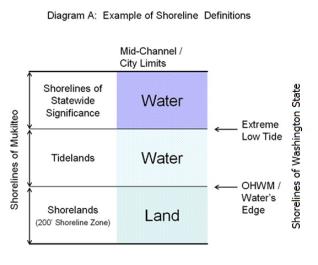
“Overwater structure” means a structure extending on or over the surface of the water which has one or more walls, with or without a roof.
“Panhandle (pipestem or flag) lot” means a lot connected to the street with a narrow access corridor not less than twenty feet wide and not more than one hundred and fifty feet long and situated so that another lot is located between the main portion of the flag lot and the street. Such lots are only permitted subject to the following conditions:
1. That the access corridor has and shall maintain a minimum height clearance of twelve feet;
2. That in platted subdivisions no more than two such lots shall occur for every fifteen lots in the subdivision;
3. That in platted subdivisions such lots shall be restricted to use in cul-de-sacs or where topography substantially interferes with the normal frontage required by the underlying zoning district; and
4. That in platted subdivisions use of such lots shall require a showing that they are necessary to maintain the integrity and quality of the proposed development.
“Pier” means a general term including docks and similar structures consisting of a fixed or floating platform extending from the shore over the water secured or supported by pilings. Piers may also be used for fishing.
“Pile,” “pilings” and “pile driving” means a column of wood or steel or concrete that is driven into the ground to provide support for a structure, a number of piles and the process of installing piles into the ground.
“Priority habitat” means a habitat type with unique or significant value to one or more species. An area classified and mapped as priority habitat must have one or more of the following attributes:
1. Comparatively high fish or wildlife density;
2. Comparatively high fish or wildlife species diversity;
3. Fish spawning habitat;
4. Important wildlife habitat;
5. Important fish or wildlife seasonal range;
6. Important fish or wildlife movement corridor;
7. Rearing and foraging habitat;
8. Important marine mammal haul-out;
9. Refugia habitat;
10. Limited availability;
11. High vulnerability to habitat alteration;
12. Unique or dependent species; or
13. Shellfish bed.
A priority habitat may be described by a unique vegetation type or by a dominant plant species that is of primary importance to fish and wildlife (such as oak woodlands or eelgrass meadows). A priority habitat may also be described by a successional stage (such as old growth and mature forests). Alternatively, a priority habitat may consist of a specific habitat element (such as a consolidated marine/estuarine shoreline, talus slopes, caves, snags) of key value to fish and wildlife. A priority habitat may contain priority and/or nonpriority fish and wildlife.
“Priority species” means species requiring protective measures and/or management guidelines to ensure their persistence at genetically viable population levels. Priority species are those that meet any of the criteria listed below.
1. State-Listed or State Proposed Species. State-listed species are those native fish and wildlife species legally designated as endangered (WAC 232-12-014), threatened (WAC 232-12-011), or sensitive (WAC 232-12-011). State proposed species are those fish and wildlife species that will be reviewed by the Department of Fish and Wildlife (POL-M-6001) for possible listing as endangered, threatened, or sensitive according to the process and criteria defined in WAC 232-12-297.
2. Vulnerable Aggregations. Vulnerable aggregations include those species or groups of animals susceptible to significant population declines, within a specific area or statewide, by virtue of their inclination to congregate. Examples include heron colonies, seabird concentrations, gravid (egg bearing) female Dungeness crab and marine mammal congregations.
3. Species of recreational, commercial, and/or tribal importance. Native and nonnative fish, shellfish, and wildlife species of recreational or commercial importance and recognized species used for tribal ceremonial and subsistence purposes that are vulnerable to habitat loss or degradation.
4. Species listed under the federal Endangered Species Act as either candidate, threatened, or endangered.
“Provisions” means policies, regulations, standards, guideline criteria or environment designations.
“Public access” is a means of physical approach to and along the shoreline available to the general public. Public access may also include visual approach.
“Restore,” “restoration” or “ecological restoration” means the reestablishment or upgrading of impaired ecological shoreline processes or functions. This may be accomplished through measures including, but not limited to, revegetation, removal of intrusive shoreline structures and removal or treatment of toxic materials. Restoration does not imply a requirement for returning the shoreline area to aboriginal or pre-European settlement conditions.
“Shall” means a mandate; the action must be done.
“Shorelands” or “shoreland areas” means those lands extending landward for two hundred feet in all directions as measured on a horizontal plane from the ordinary high water mark; floodways and contiguous floodplain areas landward two hundred feet from such floodways; and all wetlands and river deltas associated with the streams, lakes, and tidal waters which are subject to the provisions of this title; the same to be designated as to location by the Department of Ecology.
“Shoreline” means the water and submerged lands of Port Gardner Bay, Possession Sound, Lake Serene, and including all shorelines of the state and shorelines of statewide significance as defined in RCW 90.58.030. See Diagram A under “ordinary high water mark.”
“Shoreline activity” means an activity associated with use of the shoreline or the use of energy toward a specific action or pursuit. Examples of shoreline activities include, but are not limited to, fishing, swimming, boating, dredging, fish spawning, wildlife nesting, or discharging of materials. Not all activities necessarily require a shoreline location.
“Shoreline administrator” means the city of Mukilteo planning director or designee.
Shoreline Appeal—Date of Filing. The “date of filing” varies according to the type of permit being appealed:
1. An appeal of the city’s approval or denial of a substantial development permit or the city’s denial of a variance or conditional use permit, the “date of filing” is the date that Ecology actually receives a completed filing from the city on its permit decision.
2. An appeal of a conditional use permit or variance that has been approved by the city and approved or denied by Ecology, the “date of filing” is the date that Ecology transmits its final decision or order to the city, not the date the city actually receives the decision or order.
3. Where a project involves both a substantial development permit and a conditional use permit or variance, the latest applicable date of filing may be used in filing the project appeal.
For shoreline appeal process and timelines, the requirements of RCW 90.58.180 shall be followed.
“Shoreline areas” and “shoreline jurisdiction” means all “shorelines of the state” and “shorelands” as defined in RCW 90.58.030.
“Shoreline designations” means the seven shoreline overlay zones in the city: urban waterfront, urban waterfront park, urban conservancy, urban railroad, aquatic urban, aquatic urban conservancy, and urban lakefront.
“Shoreline master program” or “master program” or “SMP” means the comprehensive use plan for a described area, and the use regulations together with maps, diagrams, charts, or other descriptive material and text, a statement of desired goals, and standards developed in accordance with the policies enunciated in RCW 90.58.020. As provided in RCW 36.70A.480, the goals and policies of a shoreline master program for a county or city approved under Chapter 90.58 RCW shall be considered an element of the county or city’s comprehensive plan. All other portions of the shoreline master program for a county or city adopted under Chapter 90.58 RCW, including use regulations, shall be considered a part of the county or city’s development regulations.
“Shoreline modifications” means those actions that modify the physical configuration or qualities of the shoreline area, usually through the construction of a physical element such as a dike, breakwater, pier, weir, dredged basin, fill, bulkhead, or other shoreline structure. They can include other actions, such as clearing, grading, or application of chemicals.
“Shoreline restoration project” means a project designed to restore impaired ecological function of a shoreline.
“Shoreline stabilization—hard structural” means erosion control practices using hardened structures that armor and stabilize the shoreline from further erosion. Hard structural shoreline stabilization typically uses concrete, boulders, dimensional lumber or other materials to construct linear, vertical or near-vertical faces. These include bulkheads, riprap, groins, and similar structures.
“Shoreline stabilization—soft structural” means erosion control and restoration practices that contribute to restoration, protection or enhancement of shoreline ecological functions. Soft shoreline stabilization typically includes a mix of gravels, cobbles, boulders, logs and native vegetation placed to provide stability in a nonlinear, sloping arrangement.
“Shoreline use” means the commitment of land or water surface to a given purpose or activity. Examples of shorelines uses include, but are not limited to, residential units, parks, marinas, open space, office buildings, ports, restaurants, wildlife preserves, utilities, essential public facilities or even nonuse. Not all uses, however, are necessarily reasonable or appropriate for a shoreline location.
“Shorelines of Mukilteo” means the total of all the “shorelands” (extending landward two hundred feet from the water’s edge or OHWM) and the “shorelines of the state” (areas of Puget Sound lying seaward of the water’s edge or ordinary high water mark) within the city limits, being those areas covered by the city’s shoreline master program. See Diagram A under “ordinary high water mark.” Shoreline designations include both the upland and the water or aquatic environment.
“Shorelines of statewide significance” within the city’s jurisdiction, means all of the water areas of Possession Sound and Port Gardner Bay lying seaward of the line of extreme low tide, out to the city limits or to mid-channel. See Diagram A under “ordinary high water mark.”
“Shorelines of the state” means those areas of Puget Sound lying seaward of the water’s edge or ordinary high water mark. See Diagram A under “ordinary high water mark.”
“Should” means that the particular action is required unless there is a demonstrated, compelling reason, based on policy of the Shoreline Management Act and this title, against taking the action.
“Significant vegetation removal” means the removal or alteration of trees, shrubs, and/or groundcover by clearing, grading, cutting, burning, chemical means, or other activity that causes significant ecological impacts to functions provided by such vegetation. The removal of invasive or noxious weeds does not constitute significant vegetation removal. Tree pruning, not including tree topping, where it does not affect ecological functions, does not constitute significant vegetation removal.
“State master program” means the cumulative total of all shoreline master programs and amendments thereto approved or adopted by rule by the Department.
“Steep slopes” or “geologically sensitive slopes” means those areas within the city that are:
1. Affected by, contain, or exhibit unstable or potentially unstable soil types, steep slopes, erosion, earth movement, slides, surface water runoff, ground water, liquefaction, within the one-hundred-year floodplain, or within a tsunami hazard area.
2. Within the designated geologic sensitive area as shown on the city’s “geologic sensitive areas” map (see Attachment A at the end of Chapter 17B.52A).
3. Areas that may not be suited to development consistent with public health, safety, or environmental standards, because of their susceptibility to erosion, sliding, earthquake, or other geological events as designated by WAC 365-190-080(4).
“Substantially degrade” means to cause significant ecological impact.
“Tidelands” means those areas lying between the water’s edge or ordinary high water mark (OHWM) and the line of extreme low water. See Diagram A under “ordinary high water mark.”
“Utility uses” means all services and facilities that produce, convey, store, or process power, gas, sewage, stormwater, communications, oil, waste, water, and the like. Utilities also include pump/lift stations and associated emergency generators.
“Water courses/streams” means the areas to which surface and subsurface waters naturally flow and which form a continuous channel through which water descends to natural outlets.
“Water-dependent use” means a use or portion of a use which cannot exist in a location that is not adjacent to the water and which is dependent on the water by reason of the intrinsic nature of its operations.
“Water enjoyment use” means a recreational use or other use that facilitates public access to the shoreline as a primary characteristic of the use; or a use that provides for recreational use or aesthetic enjoyment of the shoreline for a substantial number of people as a general characteristic of the use and which through location, design, and operations ensures the public’s ability to enjoy the physical and aesthetic qualities of the shoreline. In order to qualify as a water-enjoyment use, the use must be open to the general public and the shoreline-oriented space within the project must be devoted to the specific aspects of the use that fosters shoreline enjoyment.
“Water-oriented use” means a use that is water-dependent, water-related, or water-enjoyment, or a combination of such uses.
“Water quality” means the physical characteristics of water within shoreline jurisdiction, including water quality, hydrological, physical, chemical, aesthetic, recreation-related, and biological characteristics. Where used in this title, the term “water quality” refers only to development and uses regulated under this title and affecting water quality, such as impermeable surfaces and stormwater handling practices. “Water quality,” for purposes of this title, does not mean the withdrawal of ground water or diversion of surface water pursuant to RCW 90.03.250 through 90.03.340.
“Water-related use” means a use or portion of a use which is not intrinsically dependent on a waterfront location but whose economic viability is dependent upon a waterfront location because:
1. The use has a functional requirement for a waterfront location such as the arrival or shipment of materials by water or the need for large quantities of water; or
2. The use provides a necessary service supportive of the water-dependent uses and the proximity of the use to its customers makes its services less expensive and/or more convenient.
“Water’s edge” means the line of the ordinary high water mark (OHWM).
“Wetland” means areas that are inundated or saturated by surface water or groundwater at a frequency and duration sufficient to support, and that under normal circumstances do support, a prevalence of vegetation typically adapted for life in saturated soil conditions. Wetlands generally include swamps, marshes, bogs, and similar areas. Wetlands do not include those artificial wetlands intentionally created from nonwetland sites, including, but not limited to, irrigation and drainage ditches, grass-lined swales, canals, detention facilities, wastewater treatment facilities, farm ponds, and landscape amenities, or those wetlands created after July 1, 1990, that were unintentionally created as a result of the construction of a road, street, or highway. Wetlands may include those artificial wetlands intentionally created from nonwetland areas to mitigate the conversion of wetlands.
“Wetland delineation” means a technical procedure performed by a wetland specialist to determine the area of a wetland, ascertaining the wetland’s classification, function, and value, and to define the boundary between a wetland and adjacent uplands. Identification of wetlands and delineation of their boundaries pursuant to this title shall be done in accordance with the approved federal wetland delineation manual and applicable regional supplements. All areas within the city meeting the wetland designation criteria in that procedure are hereby designated critical areas and are subject to the provisions of this program.
“Wetland report” is a report prepared by a wetland specialist that identifies all shoreline areas, water features, floodplains, wetlands, and other critical areas and their related buffers within three hundred feet of the project area. The report at a minimum shall contain: wetland delineation and required buffers, acreage, category, vegetative characteristics, soil conditions, water resources, functional evaluation, avoidance and sequencing measures, and proposed mitigation if proposed.
“Wetlands specialist” is a person who has earned a minimum of a bachelor’s degree in biology, natural resources, or physical sciences with specific or related course work in wetland ecology, botany, or soils science from an accredited college or university, and two years professional experience in wetland delineation, wetland functional assessment and mitigation techniques or equivalent experience; or any person certified by the U.S. Army Corps of Engineers or Society of Wetland Scientists. (Ord. 1427 § 3 (Exh. C) (part), 2019: Ord. 1295 § 10 (Exh. 1B) (part), 2011)