


Chapter 17B.20
BULK REGULATIONS
Sections:
17B.20.030 Panhandle (pipestem) lots.
17B.20.050 Sight distance triangle.
17B.20.060 Fences and freestanding walls.
17B.20.065 Development agreements.
17B.20.070 Additional development regulations for the WMU district.
17B.20.010 Lot requirements.
Lot dimensions and building heights shall conform to the requirements listed in Table 1, Bulk Matrix, unless modified elsewhere in this title. (Ord. 1427 § 3 (Exh. C) (part), 2019: Ord. 1295 § 10 (Exh. 1B) (part), 2011)
17B.20.020 Bulk matrix.
A. The bulk matrix contains setback, lot coverage, building height and lot dimension regulations for all zones in the city. The following is a listing of abbreviations used in the bulk matrix and their meanings:
1. IBC = International Building Code;
2. sf = square feet;
3. row = right-of-way;
4. C/L = centerline.
|
Zone |
Maximum Building Height1, 15 |
Minimum Lot Area |
Minimum Lot Width |
Minimum Average Lot Depth |
Minimum Setbacks3 |
Maximum Lot Coverage |
||||||
|---|---|---|---|---|---|---|---|---|---|---|---|---|
|
Setback Line |
Lot Line |
Corner Lot Line |
Front2 |
Interior (Side) |
Corner (Side) |
Rear |
Setback From Top of Riprap |
|||||
|
Urban Waterfront |
||||||||||||
|
WMU |
35' |
None |
None |
None |
None |
None |
None |
None |
None |
None12 |
20'12 |
None13 |
|
DB |
35' |
None |
25' |
25' |
25' |
None |
None |
None |
None |
None12 |
35'—50'12 |
None |
|
Urban Waterfront Park |
||||||||||||
|
POS |
25'—35'14 |
None |
None |
None |
None |
None |
None |
None, except 20' next to residential zone |
None |
IBC, except 20' next to residential zone |
35'—50'12 |
None |
|
Urban Conservancy |
||||||||||||
|
RD 7.5 |
30' |
7,500 sf |
50' |
30' |
60' |
85' |
20' |
5'; with 15' of total side yard |
20'4 |
20', or 15' for corner lots'5 |
Top of Slope + 25' |
35% |
|
RD 8.4 |
35' |
8,400 sf |
None |
65' |
70' |
None |
20' |
5' |
20' |
5'5 |
Top of Slope + 25' |
35% |
|
RD 12.5 |
30' |
12,500 sf |
60' |
40' |
60' |
85' |
25' |
5'; with 15' of total side yard |
20'4 |
25'5 |
Top of Slope + 25' |
30% |
|
RD 12.5(S) |
35' |
12,500 sf |
None |
75' |
80' |
None |
20' |
5' |
20' |
5'5 |
Top of Slope + 25' |
35% |
|
MR |
35' |
7,500 sf6 |
None |
60' |
70' |
None |
25' |
Varies7 |
Varies7 |
Varies7 |
Top of Slope + 25' |
40% |
|
MRD |
Varies8 |
7,500 sf9 |
50' |
30' |
60' |
85' |
25' |
Varies10 |
20'4 |
20' |
Top of Slope + 25' |
40% |
|
HI |
65' |
None |
None |
None |
None |
None |
25' |
IBC next to commercial zones, 50' next to residential zones |
25' |
IBC next to commercial zones, 50' next to residential zones |
200' |
None |
|
Aquatic Urban and Aquatic Urban Conservancy (Tidelands). See development regulations for permitted uses and in and over water structures. |
||||||||||||
|
All |
N/A |
None |
None |
None |
None |
None |
None |
None |
None |
None |
None |
None |
|
Urban Lakefront |
||||||||||||
|
RD 8.4 |
35' |
8,400 sf |
None |
65' |
70' |
None |
20' |
5' |
20' |
5'5 |
75' |
35% |
|
Urban Railroad (Applies to BNSF Railroad Right-of-Way Only). See development standard regulations for restrictions. |
||||||||||||
|
All |
N/A |
None |
None |
None |
None |
None |
None |
None |
None |
None |
None |
None |
B. Reference Notes for Bulk Matrix.
1. Appurtenances such as stairwells, mechanical equipment, and elevator shafts that do not exceed the maximum building height by more than ten feet are allowed in the following zones: WMU, HI, and POS.
2. Front setbacks shall be measured from the edge of the front property line.
3. For the setback requirements next to critical slope areas, refer to Section 17B.52A.060.
4. Corner lot setbacks for the RD 12.5, RD 7.5 and MRD zones: twenty feet for side adjoining a street; otherwise same setbacks as specified for interior lots for the side adjoining an interior lot. For dwellings that border a private road from which they do not receive vehicular access, the required setback shall be one-half the width of the right-of-way plus ten feet. For those dwellings that receive primary vehicular access from a private road, the setback required from the centerline of the right-of-way shall be one-half the width of the right-of-way plus twenty feet.
5. Detached garages, carports and accessory buildings. All detached single-family residential garages, carports and accessory buildings shall be sited outside the two-hundred-foot shoreline zone unless there is no other location to locate the structure.
6. In the MR zone, the maximum density shall be calculated based on two thousand square feet of land per dwelling unit. In a PRD (MR) density shall be based on one thousand seven hundred square feet.
7. MR Setbacks.
a. Single-family detached structures shall have the minimum setbacks required in the RD 8.4 zone.
b. Other structures shall have a minimum rear setback of twenty-five feet and a minimum total side setback of fifteen feet, with a minimum single side setback of five feet. Building separation shall be a minimum of fifteen feet.
c. Multistory structures over two stories shall increase setbacks for each additional story as follows:
i. Front: three feet;
ii. Rear: three feet;
iii. Side: five feet total with minimum side increased by three feet;
iv. Building separation: five feet.
8. Building height in the MRD zone may extend to forty-five feet (except thirty feet on level sites: zero to eight percent); and provided, that the developer demonstrate to the satisfaction of the city council that the height is consistent with the following criteria:
a. The project shall not obstruct the sound and mountain views from other single-family residential properties by more than twenty percent;
b. Shall have access to major trafficways;
c. Shall not exceed the height limits as provided in this chapter;
d. Shall not exceed the density limits as provided in this chapter;
e. Shall not exceed the site coverage as provided in this chapter.
9. In the MRD zone, the minimum usable land area per dwelling unit (for computations of density) shall be three thousand three hundred fifty square feet except that where computations result in a partial dwelling unit greater than three-fourths, a full unit shall be allowed for lots which meet the minimum lot area requirements.
10. Interior side setbacks in the MRD zone shall be measured as follows:
a. One and two stories, five feet (except that the sum of the two side yards must not be less than fifteen feet) with not less than fifteen feet between structures on adjoining properties;
b. Three stories, twelve feet (except that the sum of the two side yards must not be less than twenty-four feet);
c. Four stories, fifteen feet (except that the sum of the two side yards must not be less than twenty-four feet).
11. Height of Buildings.
a. The height of buildings within the two-hundred-foot shoreline jurisdiction shall be a maximum of thirty-five feet with no more than two stories in order to allow for a pitched roof no less than 6:12 pitch over fifty percent of the roof area. No flat roofs are allowed.
b. The height of buildings outside the shoreline management program area and north of BNSF right-of-way shall not exceed thirty-five feet with no more than three stories to allow for pitched roofs and building stories shall be tiered back to allow for views from different floors, while limiting the blockage of views from up the hill at 2nd Street.
c. Building proposals for essential public facilities may exceed these height limits as needed provide the facility. However, the developer/agency shall provide documentation showing that the proposed height is the minimum necessary to meet the operational needs of the facility.
12. Buildings shall be set back twenty feet from the waterfront riprap to allow for a fifteen-foot pedestrian promenade with a five-foot building setback from the pedestrian promenade.
13. Breaks in the facade and building footprint along the waterfront shall be included to retain water views from Front Street and for pedestrian access to the waterfront promenade and beach, as regulated by the shoreline master program plan. All new buildings or additions to buildings located on land areas adjacent to Possession Sound and Port Gardner Bay shall be designed and constructed in such a manner that each floor provides the following amount of horizontal and vertical space open to public access and open to vistas of the sound and the bay:
a. On the first floor, twenty percent of lot width shall be open to public access and vistas to and of Possession Sound and Port Gardner Bay;
b. The equivalent of twenty-five percent of lot depth shall be open for public vistas on all floors above the first;
c. A structure located on the north side of Front Street may not extend for more than one hundred lineal feet on the first floor without being interrupted by a space at least ten feet in width that is open to public access and vistas to and of Possession Sound and Port Gardner Bay.
14. Building height in the POS district: thirty-five feet, except twenty-five feet within two hundred feet of the ordinary high water mark at the Mukilteo Lighthouse Park.
15. Essential public facilities are exempt from the maximum building height regulation. (Ord. 1427 § 3 (Exh. C) (part), 2019: Ord. 1295 § 10 (Exh. 1B) (part), 2011)
17B.20.030 Panhandle (pipestem) lots.
Panhandle lots shall be allowed subject to the following additional requirements:
A. Minimum street lot frontage of twenty feet;
B. Maximum length of one hundred fifty feet;
C. Area calculations are determined at the minimum lot width line;
D. Minimum height clearance of twelve feet;
E. Allowed on no more than two lots for every fifteen lots of subdivided property;
F. Allowed in cul-de-sacs or where topography does not allow the normal frontage required by the underlying zone; and
G. Allowed only if necessary to maintain the integrity and quality of the proposed development. (Ord. 1427 § 3 (Exh. C) (part), 2019: Ord. 1295 § 10 (Exh. 1B) (part), 2011)
17B.20.040 Reducing lot area.
No minimum lot area shall be so reduced or diminished that the setbacks or other open spaces shall be smaller than prescribed by this title, nor shall the land use density be increased in any manner except in conformity with the regulations established by this title. Government structures and facilities shall have no minimum lot area. (Ord. 1427 § 3 (Exh. C) (part), 2019: Ord. 1295 § 10 (Exh. 1B) (part), 2011)
17B.20.050 Sight distance triangle.
No structures, fences, or freestanding walls shall be built as to obstruct the visibility at an intersecting street. In addition, for public safety reasons vegetation shall not be allowed to grow to a height or width which could obstruct visibility at an intersection. Unobstructed visibility at corners is measured according to the following diagrams.
A. Single-Family Residential Properties. Unobstructed vision at corners for all fences, freestanding walls, and hedges shall be measured in accordance with the following sight distance triangle:
1. Where posted speed on both streets is twenty-five miles per hour or less; and
2. No stop signs or other traffic control features are present on either street.
Diagram A
Single-Family Residential Sight Distance Triangle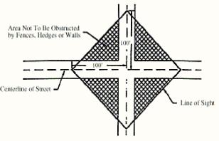
B. Properties Adjacent to a Controlled Intersection. Properties adjacent to a controlled intersection shall be designed to maintain unobstructed vision at intersections in accordance with the following standards:
1. Unobstructed sight distances shall be designed according to the following speed limit schedule:
|
Posted Speed Limit (on the public right-of-way) |
25 mph |
30 mph |
35 mph |
40 mph |
|
Sight Distance |
300' |
400' |
530' |
600' |
2. These distances are required for an approaching vehicle to be able to reduce speed or stop in order to prevent a collision.
3. For road approaches where left turns are not allowed, a sight triangle need only be provided to the left, as shown.
4. For road approaches where left turns are allowed, provide a sight triangle to the right in addition to the one to the left. The sight distance to the right is measured along the centerline of the roadway.
5. Sight distance numbers are for passenger vehicles only. If there are a significant number of trucks, greater than ten percent of ADTs (average daily trips), using the intersection, then the sight distance shall be increased in accordance with the AASHTO requirements as determined by the public works director.
Diagram B
Sight Distance at Controlled Intersections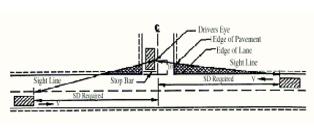
(Ord. 1427 § 3 (Exh. C) (part), 2019: Ord. 1295 § 10 (Exh. 1B) (part), 2011)
17B.20.060 Fences and freestanding walls.
A. Fences and Freestanding Walls. Fences and freestanding walls are allowed under the following conditions:
1. Materials.
a. Fence materials shall consist of metal, wood, and/or masonry units, and shall be consistent with the architectural character of adjacent structures. Fencing materials should create a solid and non-see-through separation or screening.
b. Chain link fences shall only be allowed as a safety separation between stormwater facilities and other hazards (other than swimming pools). Only black vinyl coat or black painted chain link is allowed.
c. Adjoining, adjacent, and connecting fences shall be similar in design and constructed from like materials.
2. Height.
a. In residential zones, fences and freestanding walls located in side and rear yards may not exceed six feet in height and must be stepped down to not more than four feet or forty-eight inches at the front setback line. Decorative features, artwork, or trellises may be allowed on a fence as along as the features do not add additional screening or opaqueness which in effect increases the height of the fence.
b. In commercial and industrial zones, fences and freestanding walls may not exceed eight feet in height and may not obstruct the vision of an intersecting street. Unobstructed vision at corners is measured according to the sight distance triangle requirement.
c. Fences around schools and utility substations may not exceed eight feet in height, except as allowed under the administrative modification section or with an approved conditional use permit, and may not obstruct the visions of an intersecting street. Unobstructed vision at corners is measured according to the sight distance triangle requirement diagram.
d. For purposes of measuring fence and freestanding wall height, the height shall be measured from the lowest point of the fence touching the ground to the highest point on either side of the fence. If a fence is placed upon a rockery or retaining wall, the fence must be set back a minimum of two feet, or the height of the fence and rockery/retaining wall combined will be used to measure the overall height of the fence or freestanding wall.
3. Placement. For safety reasons, fences and freestanding walls on corner lots may not be constructed of any material or built to a height which would obstruct vision of an intersecting street. Unobstructed vision at corners is measured according to the sight distance triangle requirement diagram.
B. Administrative Modifications. If the strict application of this section would restrict reasonable screening of a person’s property, the planning director or his/her designee may allow deviations from this section under the following conditions and criteria:
1. The applicant shall submit a written statement, site plan, and elevation drawings describing the proposal and why the deviation is necessary.
2. The adjoining property owners shall be notified of the requested modification and given fourteen calendar days to comment on the proposal.
3. When reviewing the modification request, the planning director or his/her designee must find that the following criteria have been met:
a. Fences or freestanding walls may not be increased by more than two feet in height;
b. Sight distance vision of an intersecting street may not be obstructed. Unobstructed vision at corners is measured according to the sight distance triangle diagram;
c. The deviation must be necessary because of special circumstances relating to the topography, location, or surroundings of the subject property; and
d. The deviation is not objectionable to adjacent property owners.
C. Variances. Increases in the height of fences or freestanding walls by more than two feet in height shall be subject to the review procedures and requirements of Section 17B.64.040, variances. (Ord. 1427 § 3 (Exh. C) (part), 2019: Ord. 1295 § 10 (Exh. 1B) (part), 2011)
17B.20.063 Hedges.
For safety reasons, trees, hedges, and/or vegetation shall not be allowed to grow to a height or width which would obstruct vision at intersecting streets. Unobstructed vision at corners is measured according to the sight distance triangle diagram. (Ord. 1427 § 3 (Exh. C) (part), 2019: Ord. 1295 § 10 (Exh. 1B) (part), 2011)
17B.20.065 Development agreements.
A. The city council may approve a development agreement for any parcel whose zoning falls within the commercial, public categories on the permitted use matrix which contains project elements, a vesting period, and establishes or modifies the development standards on a site-specific basis, including but not limited to density, parking, streets, setbacks, building separation, landscaping and other standards, pursuant to the procedures of RCW 36.70B.170 through 36.70B.210.
B. Development agreements may not deviate from the permitted uses as allowed as listed in this code.
C. Procedure—Community Meeting. Within thirty days of the notice of application, a community meeting shall be held to obtain public comments on the proposed development agreement. The purpose of the meeting is to identify issues, concerns and/or constraints which may affect the project and surrounding community. The community meeting is not intended to be part of the official record of the application. At a minimum the development agreement shall include:
1. An outline of the agreement;
2. Bubble diagram showing proposed uses and access;
3. List of permitted uses and issues.
D. Community Meetings. For projects that will include a development agreement, the following notice and comment periods apply:
1. The notice of application shall include the date, time and place for the community meeting.
2. Written comments regarding the development agreement may be submitted before the community meeting, at the community meeting, or within fourteen days after the community meeting.
E. Final Decision. Consideration and a decision on the final draft of the development agreement shall be done after a public hearing but prior to the final decision on the related project. (Ord. 1427 § 3 (Exh. C) (part), 2019: Ord. 1295 § 10 (Exh. 1B) (part), 2011)
17B.20.070 Additional development regulations for the WMU district.
A. Commercial uses shall comply with the following:
1. All the uses shall be contained within an entirely closed structure with the exception of eating establishments wherein outdoor eating space does not obstruct vehicular movement, parking, and ferry loading facilities.
2. Commercial uses located north of the Burlington Northern Santa Fe (BNSF) railroad tracks shall not be so located as to obstruct or impede pedestrian access of beach areas at low tide waters as established by the mean low tide mark. (Ord. 1427 § 3 (Exh. C) (part), 2019: Ord. 1295 § 10 (Exh. 1B) (part), 2011)