


Chapter 17.07
PROPERTY GRADING REGULATIONS
Sections:
17.07.040 Clearing and grading permit required.
17.07.050 Responsibility to have permit.
17.07.060 Complete application.
17.07.070 Criteria for approval.
17.07.080 Authority to inspect for compliance.
17.07.090 Expiration of permits and applications.
17.07.100 Related codes and regulations.
17.07.110 Violations and refusal of development applications.
17.07.140 Operating conditions and standards of performance.
17.07.150 Grading – Land development projects.
17.07.160 Grading – Individual lots.
17.07.200 Rock and retaining walls.
17.07.250 Performance security.
17.07.260 Liability insurance required.
17.07.270 Stop work order/permit revocation.
17.07.300 Violations – Penalties.
17.07.010 Purpose.
A. This chapter is intended to regulate clearing, excavation, grading and earthwork construction, including cuts and fills, within the city of Newcastle in order to protect public health, safety, welfare, and aesthetics by:
1. Minimizing adverse stormwater impacts generated by the removal of vegetation and alteration of landforms;
2. Protecting water quality from the adverse impacts associated with erosion and sedimentation;
3. Minimizing aquatic and terrestrial wildlife habitat loss caused by the removal of vegetation;
4. Protecting critical areas from adverse clearing and grading activities;
5. Preventing damage to property and harm to persons caused by excavations and fills;
6. Minimizing the height and number of rock and retaining walls;
7. Minimizing the height, steepness, and number of graded slopes;
8. Establishing minimum access requirements to and around buildings for safety, security, maintenance, and general use and enjoyment of property;
9. Minimizing the amount of grading after a property is developed and prepared for building construction;
10. Establishing administrative procedures for the issuance of permits, approval of plans, and inspection of clearing and grading operations; and
11. Providing enforcement and penalties for the violation of this chapter.
B. This chapter establishes the administrative procedure for:
1. Issuance of independent clearing and grading permits when no other building permit or ERP permit is associated with the proposed clearing or grading;
2. Approval of plans and inspection of clearing and grading operations, and providing for enforcement and penalties for the violation of this chapter. (Ord. 2021-634 § 3).
17.07.020 Definitions.
As used in this title, unless the context or subject matter clearly requires otherwise, the words or phrases defined in this chapter shall have the indicated meanings. If there are conflicts between the definitions of this title and other titles of the Newcastle Municipal Code, the provisions of this title shall prevail.
“Applicant” means a property owner or any person with written authority to act on behalf of the owner in an application for a development proposal, permit or approval.
“Arborist” means an individual certified by the International Society of Arboriculture (ISA) for his or her training in the art and science of planting, caring for, and maintaining trees.
“Bench” is a relatively level step excavated or constructed into earth material on which fill is to be placed.
“Berm” is a mound or raised area used for the purpose of screening a site or operation.
“Best management practices (BMPs)” means a schedule of activities, prohibitions of practices, maintenance procedures, and structural and/or managerial practices approved by Ecology that, when used singly or in combination, prevent or reduce the release of pollutants and other adverse impacts to waters of Washington State.
“Borrow” means earth material acquired from an off-site location for use in grading on a site.
“City” means the city of Newcastle.
“Civil engineer” means an engineer who is licensed as a professional civil engineer by the state of Washington.
“Clearing” means cutting, topping or removal of vegetation or other organic plant matter by physical, mechanical, chemical, or other means. “Clearing” also means the limbing of significant trees that removes more than 25 percent of the tree’s living crown.
“Clearing and grading permit” means the written permission of the director to the permittee to proceed with the act of clearing and grading within the provisions of this chapter. The clearing and grading permit includes the associated approved plans and any conditions of approval as well as the permit form itself.
“Compaction” is the densification of a fill by mechanical means.
“Critical areas” means the environmentally sensitive areas described in NMC Title 18.
“Crown” means the collective branches on a tree that support the tree foliage and form the tree canopy.
“Cut wall” means a retaining wall used to hold back earth after excavating into the earth, at a new, lower grade (see Figure 1 at the end of this section).
“Development proposal” means any activities requiring a permit or other approval from the city of Newcastle relative to the use or development of land.
“Director” means the director of the department of community development or his/her designee.
“Dripline” means the outer reach of a tree’s crown or canopy.
“Earth material” is any rock, natural soil or fill, or any combination thereof.
“Engineering review permit” or “ERP” means the written permission of the director to the permittee to proceed with the act of clearing, grading, street, utility, and other infrastructure improvements within the provisions of this chapter and the city of Newcastle public works standards, as adopted per NMC 12.05.010. The ERP includes the associated approved plans and any conditions of approval as well as the permit form itself. All provisions in this chapter shall also pertain to ERPs.
“Erosion” is the wearing away of the ground surface as the result of the movement of wind, water and/or ice.
“Excavation” is the removal of earth material. The term “cut” can also be used to describe excavation.
“Fill” is a deposit of earth material placed by mechanical or other means.
“Fill wall” means a retaining wall used to hold up earth that has been filled on top of the existing grade (see Figure 1 at the end of this section).
“Geotechnical engineer” or “soils engineer” means an engineer who is licensed as a professional civil engineer by the state of Washington and who has at least four years of relevant professional employment in the field of geotechnical, geological, or mining engineering.
“Grade” means the elevation of the ground surface.
1. “Existing grade” is the grade prior to grading.
2. “Rough grade” is the stage at which the grade approximately conforms to the approved plan as required in NMC 17.07.150 and 17.07.160.
3. “Finish grade” is the grade of the site at the conclusion of all grading efforts.
4. “Natural grade” is defined in Chapter 18.06 NMC.
“Grading” is any excavating, filling, removing of the duff layer, or combination thereof.
“Inflicted tree damage” means the topping of trees, the removal of more than 25 percent of the tree’s crown, the excavation* or compaction of soils within the dripline of the tree, the placement* of more than four inches of soils or fill materials within the dripline of the tree. *Note: Damage from excavations and placement of soils within a tree’s dripline can be mitigated by an engineered soil cover or drywell as recommended by a certified arborist.
“Infrastructure improvements” means streets, drainage facilities, utilities, and associated appurtenances typically constructed as part of a development project for the purposes of serving the development.
“Key” means a compacted fill placed in a trench excavated in earth material beneath the toe of a slope.
“Modular block wall” means a wall constructed of manufactured modular wall units acting as a protective facing for an exposed soil face or as a gravity retaining wall.
“Native growth protection easement (NGPE)” means an area where native vegetation is preserved for the purpose of preventing harm to property and the environment, including, but not limited to, controlling surface water runoff and erosion, maintaining slope stability, buffering, and protecting plants and animal habitat.
“Open space” means an area, unoccupied by buildings, roads, or parking areas, that has been set aside in perpetuity as a naturally vegetated area. Such open space areas may include native growth protection easements (NGPE), retained vegetated easement areas (RVEA), critical areas, and other tracts of land and easement areas set aside for this purpose.
“Permittee” means the person(s) or entity to whom a clearing and grading or engineering review permit is issued.
“Reinforced fill” or “reinforced soil” means soil fill designed by a geotechnical engineer which includes reinforcement consisting of metal or synthetic materials in bars, trips, grids, or sheets.
“Retained vegetated easement area (RVEA)” means an area intended to protect a critical area or provide and preserve a vegetated buffer by means of restricting activities which affect the vegetation existing in that area. The statement “Existing native vegetation to remain” should be noted on a landscape plan or subdivision plat and is intended to differentiate between native vegetation and naturalized, nonnative vegetation which naturally occurs through reseeding. “Native vegetation” is that which has existed in the region and was not introduced to the area by people. Examples include Douglas fir, salal and alder. “Naturalized vegetation” is a species that was introduced to the area and has spread to the extent that it occurs and propagates itself without being directly planted by people. Examples include Scotch broom, Himalaya blackberry and purple loosestrife.
“Retaining wall” means a wall designed to resist the lateral displacement of soil or other materials.
“Rockery” or “rock wall” means one or more courses of large rocks stacked near vertical in front of an exposed soil face to protect the soil face from erosion and sloughing. A rockery or rock wall is not a retaining wall. The height of a rock wall is measured from the natural grade to the top of the wall.
“Shorelines” means those lands defined as shorelines in the State Shorelines Management Act of 1971.
“Site” is any lot or parcel of land or contiguous combination thereof where projects covered by this title are performed or permitted.
“Site restoration” is the permanent restoration of lands modified under the provisions of this code, typically in the form of the establishment of vegetation and drainage facilities to control the rate and erosive force of stormwater runoff and which may include LID principles.
“Slope” is an inclined ground surface, the inclination of which is expressed as a ratio of horizontal distance to vertical distance.
“Terrace” is a relatively level step excavated or constructed in the face of a graded slope surface for drainage and maintenance purposes.
Figure 1: Grading Illustration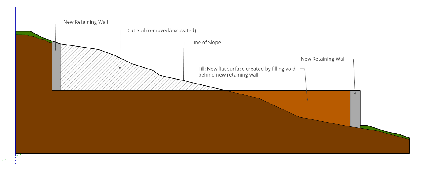
“Topping” is the shortening of the height of a tree by cutting the main or vertical trunk and its attached branches. (Ord. 2021-634 § 3).
17.07.030 Applicability.
The provisions of this chapter, regardless of whether a clearing and grading permit, engineering review permit or building permit is required, shall apply to any person, builder, developer, or property owner undertaking the task of developing, altering, clearing, or grading land, or constructing buildings in the city of Newcastle. The provisions of this chapter shall be applied to clearing and grading associated with all permit types, as deemed appropriate by the director. (Ord. 2021-634 § 3).
17.07.040 Clearing and grading permit required.
A. No person shall do any clearing or grading without first having obtained a clearing and grading permit from the director except for the following:
1. An on-site excavation for basements and/or footings of a building, retaining wall, or other structure authorized by a valid building permit, in which case the building permit shall serve as the clearing and grading permit. This shall not exempt any fill made with the material from such excavation;
2. Any on-site excavation or clearing associated with an approved ERP permit, in which case the ERP permit shall serve as the clearing and grading permit;
3. Routine landscape maintenance that does not impose inflicted tree damage (as defined by this chapter) to significant trees as defined and regulated in NMC Title 18, or installation of landscaping improvements involving not more than 50 cubic yards of excavation and fill on a single parcel of property in a 12-month period; provided, that topsoil up to a depth of six inches, regardless of quantity, may be placed on single-family residential properties without requiring a permit;
4. Maintenance of existing driveways or private access roads within their existing road prisms;
5. Any clearing or grading within a publicly owned road right-of-way or easement, for which a right-of-way use permit and/or ERP permit has been granted by the city;
6. Clearing or grading by a public agency for the following routine maintenance activities:
a. Roadside ditch cleaning;
b. Pavement maintenance;
c. Normal grading of gravel shoulders;
d. Maintenance of culverts;
e. Maintenance of flood control or other approved surface water management facilities;
f. Routine clearing within road right-of-way; and
g. Normal and routine maintenance of parks and trails;
7. Cemetery graves;
8. Excavation or fill less than four feet in vertical depth not involving more than 50 cubic yards of earth or other material on a single site;
9. Emergency tree removal to prevent imminent danger or hazard to persons or property;
10. Removal of noxious weeds, as defined in Chapter 17.10 RCW;
11. Pruning and limbing of vegetation for maintenance of aboveground electrical and telecommunication facilities;
12. Clearing or grading activities for the purposes of gathering information required by the city for application of a development proposal, such as:
a. Hand clearing of vegetation for surveying;
b. Minimal clearing and grading as required to perform geotechnical exploration to characterize geologic formations and soils; and
c. Minimal clearing and grading to install erosion and sedimentation control devices in accordance with an approved temporary erosion and sedimentation plan.
B. The following activities shall require a clearing and grading permit and shall conform to the provisions of this chapter and Chapter 18.16 NMC:
1. Clearing of 2,500 square feet of contiguous land area; or
2. Removal of, or inflicted tree damage to, 10 or more significant trees as defined under NMC 18.06.598. Tree replacement for removal or inflicted damage of significant trees shall be required to comply with on-site tree replacement in accordance with NMC 18.16.170.
C. Critical Areas. All clearing and grading within critical areas shall require a clearing and grading permit and shall conform to the provisions of this chapter and Chapter 18.24 NMC.
D. A clearing and grading permit may be issued as a component of a building permit, ERP permit, or other permit, rather than as a separate permit.
E. All clearing and grading activities within the city, regardless of whether a permit is required, shall meet the performance and restoration requirements of this chapter and shall include the use of best management practices to reduce erosion and protect water and air quality. (Ord. 2021-634 § 3).
17.07.050 Responsibility to have permit.
A separate clearing and grading permit shall be required for each lot of record associated with a construction site unless each lot of record owner is a signatory to a singular and collective clearing and grading permit. A single clearing and grading permit may cover both excavations and fills. Every person working or directing work that requires a permit under this chapter must:
A. Have a copy of the permit before starting and during all phases of the work. The permit, approved plans, and applicable terms and conditions of approval shall be kept on site at all times.
B. Be familiar with and comply with the terms and conditions of the permit and the provisions of this chapter. (Ord. 2021-634 § 3).
17.07.060 Complete application.
A. Applications shall be on forms prescribed by the department and shall include such information as deemed necessary by the director to establish compliance with this chapter. The director may waive specific submittal requirements if the director determines them to be unnecessary for the proposed work or may require additional information if needed for review of an application.
B. Minimum Requirements. Unless specifically waived by the director, applications shall include the following information:
1. A description of the work to be covered by the permit for which application is made;
2. A description of the land on which the proposed work is to be done, by lot, block, tract and house and street address, assessor’s parcel number, or similar description that will readily identify and definitively locate the proposed site;
3. A description and location of critical areas on and within 50 feet of the site;
4. A description and location of significant trees, both on site and off site, that have their driplines within two feet of any proposed or likely disturbance;
5. Estimated quantities of earthwork being moved or placed on the site;
6. Signature(s) of the property owner(s) or his/her authorized agent who shall be required to submit evidence to indicate such authority;
7. Payment of any application fee and/or development deposits imposed by the city; and
8. Any additional information as may be required by the director;
9. Plans and specifications prepared and signed by a civil engineer registered to practice in the state of Washington; provided, that plans and specifications for single-family residential construction shall not require preparation by a licensed engineer unless deemed necessary by the director. Plans shall be to a scale no larger than 24 inches by 36 inches and of sufficient clarity and detail to indicate the nature and extent of the work proposed. The plans shall include the following minimum information:
a. The name and address of the owner and the person by whom they were prepared;
b. General vicinity of the proposed site, with assessor’s parcel numbers;
c. Property, setback, and easement limits and accurate contours of existing ground and details of terrain and area drainage. Contours shall extend a minimum of 50 feet off site;
d. Limiting dimensions, elevations, and finished contours to be achieved by the grading, and proposed drainage channels and related construction;
e. Proposed clearing limits;
f. Open space and critical areas and their associated buffers and setbacks;
g. Significant trees with driplines within two feet of any proposed or potential disturbance;
h. Detailed plans of all surface and subsurface drainage devices, walls, cribbing, dams, berms, settling ponds and other protective devices to be constructed with or as a part of the proposed work, together with the maps showing the drainage area and the estimated runoff of the area served by any drains;
i. Location of any buildings, structures, or other existing improvements such as septic drainfields, roads, wells, and utilities on the property where the work is to be performed and the location of any buildings, structures, or other existing improvements on land of adjacent owners which are within 50 feet of the property or which may be affected by the proposed grading operations;
j. Landscape and rehabilitation/restoration plan as required;
k. Tree retention plan per NMC 18.16.140;
l. Utility locations;
m. Easement and right-of-way improvement locations;
10. A soils report prepared by a licensed soils or geotechnical engineer covering all portions of the project within his/her expertise including site history; geologic structures; surface conditions; subsurface conditions; recommendations for foundation support, site preparation, structural fill, slope stability and mitigation; design parameters for retaining structures and structure backfill, surface and subsurface drainage, dewatering, excavation conditions and hazards; seismic conditions, erosion and sedimentation hazards and controls; use of on-site materials for structural fill and backfill; and pavement design. The soils or geotechnical engineer shall be retained as the engineer-of-record for the duration of the project;
11. If the clearing or grading is proposed to take place in or adjacent to a critical area as regulated in Chapter 18.24 NMC, provide information as required by that chapter;
12. Other information as may be required by the director. The director may require the applicant to submit additional information when he/she finds the submitted plans, specifications and associated information are not clear enough to allow for an adequate determination, or when special conditions are found to exist that require specific explanation. (Ord. 2021-634 § 3).
17.07.070 Criteria for approval.
Before approving a proposed clearing and grading permit, the director shall evaluate the proposal and make specific determination that the proposed work conforms to all following criteria:
A. The proposed clearing and grading will not adversely affect the character of the site for present lawful uses or with the future development of the site and adjacent properties for building or other purposes as indicated by the comprehensive plan and the zoning code.
B. The proposed clearing, grading, or contour activities will not adversely affect critical areas or significant trees and is compliant with the city’s critical area regulations of Chapter 18.24 NMC, and with the city’s significant tree regulations of Chapter 18.16 NMC.
C. Identified or potential impacts on critical areas, significant trees, slopes, water bodies, aquifers, streams and drainage courses, or off-site properties or improvements have been avoided or properly mitigated.
D. The proposed clearing and grading is compliant with the city’s adopted stormwater regulations.
E. Proposed cuts and fills have been properly engineered for slope stability and erosion control, and all retaining walls and associated backfills have been properly engineered for expected loading, structural stability, and drainage.
F. Proposed retaining walls are compliant with retaining wall height standards of Chapter 18.12 NMC.
G. The proposed clearing and grading has been approved by federal, state, and local agencies having jurisdiction by laws or regulations.
H. The clearing and grading work complies with other provisions of this chapter. If the application and plans so comply, or if they are corrected or amended so as to comply, the director may issue to the applicant a clearing and grading permit. (Ord. 2021-634 § 3).
17.07.080 Authority to inspect for compliance.
A. No work that is regulated by this chapter shall be done without an approved clearing and grading permit, or that is not provided for in an approved clearing and grading permit.
B. Inspections and Right of Entry. The director is authorized to inspect the premises associated with a clearing and grading activity at any reasonable time to: (1) evaluate site conditions associated with a requested permit, (2) determine if work done on the site is in accordance with an approved clearing and grading permit, or (3) determine if work done without a permit is compliant with the provisions of this chapter; provided, that if such premises or portion thereof is occupied, the director shall first present proper credentials and demand entry; and if such premises or portion thereof be unoccupied, the director shall first make a reasonable effort to locate the owner or other persons having charge or control of the premises or portion thereof and demand entry. No owner or occupant or any other person having charge, care or control of any building, land, structure, premises, or portion thereof shall fail or neglect, after proper demand, to promptly permit entry thereon by the director for the purpose of inspection and examination pursuant to this chapter. Any person violating this subsection may be guilty of a misdemeanor. (Ord. 2021-634 § 3).
17.07.090 Expiration of permits and applications.
A. An application for a clearing and grading permit may be canceled for inactivity if an applicant fails, without reasonable justification, to respond to the department’s written request for revisions or corrections within 60 days. The director may extend the response period beyond 60 days if the applicant provides and adheres to a reasonable schedule for submitting the full revisions.
B. Clearing and grading permits expire as follows:
1. If a building permit is issued for the same site, the clearing and grading permit shall automatically expire or be extended when the building permit expires or is extended;
2. If a building permit is not issued for the same site, the clearing and grading permit shall expire as follows:
a. The permit shall expire if the authorized work has not begun within one year from the date of permit issuance, or if work is abandoned for over 180 days, unless an extension has been granted. The permittee shall be responsible for notifying the director, in writing, if delays or unforeseen circumstances are impacting the start or continuation of the work.
b. If the authorized work is continually performed, the permit shall expire one year from the date of issuance unless a different time frame is specified on the permit or an extension is granted as follows:
i. Two one-year extensions may be granted by the director; provided, that conditions which were relevant to issuance of the permit have not changed substantially and no material detriment to the public welfare will result from the extension. The permittee shall be responsible for notifying the director, in writing, if delays or unforeseen circumstances are impacting the completion of the work.
C. When a permit is ready to be issued, the applicant shall be notified and must pick up the permit within 60 days of notification. If the permit is not picked up, it may be canceled by the director and become null and void. If the permit is canceled, the director shall notify the applicant by mail. (Ord. 2021-634 § 3).
17.07.100 Related codes and regulations.
A. The requirements of this chapter are in addition to other city codes, standards, and regulations. Where conflicts exist between the provisions of this chapter and other codes and standards, the most restrictive or contextually relevant provisions shall apply, as determined by the director.
B. In addition to the provisions of this chapter, the applicant shall comply with applicable engineering standards contained in the city of Newcastle public works standards as adopted per NMC 12.05.010, Chapter Appendix J of the International Building Code as adopted per NMC 15.10.010, or equivalent standards approved by the director. In addition, the applicant shall comply with those minimum requirements for temporary erosion and sedimentation control and associated BMPs set forth in Chapter 13.10 NMC.
C. Requirements administered by other state and local agencies may also apply. The responsibility for determining the existence and application of other agency requirements rests solely with the applicant; provided, that to the extent known, the city will inform the applicant of other agency requirements or permits that may apply to a site. (Ord. 2021-634 § 3).
17.07.110 Violations and refusal of development applications.
If clearing and grading inconsistent with the purposes and requirements of this chapter has occurred on a site, the city shall not accept or grant any development permits or approvals for the site unless the applicant adequately restores the site. The director shall require appropriate restoration of the site under an approved restoration plan which shall include a time schedule for compliance if significant resource damage has or may occur. If restoration has not been completed within the time established by the department, the director shall order restoration using city funds and seek restitution from the property owner through liens or other available legal methods. (Ord. 2021-634 § 3).
17.07.120 Hazards.
The director has the authority to determine whether an existing site, as a result of clearing, grading, excavation, filling, or other similar activity, has become a hazard which may endanger property or adversely affect the safety, use or stability of a public way or drainage channel. Upon receipt of written notice from the director of such hazard, the owner or agent in control of said property upon which the clearing, grading, excavation, filling, or other similar activity is located, shall restore the affected site within the period specified in the notice. Restoration shall be by means of corrective action to repair or modify such clearing, grading, excavation, filling, or other in order to remove the hazard and bring the site into conformance with the requirements of this chapter. (Ord. 2021-634 § 3).
17.07.130 Variances.
A. Variances must be requested in writing. Variances to the provisions of this chapter may be granted in accordance with NMC 18.44.040 and shall be considered an administrative variance, unless the variance request is for wall height. Wall height variances shall be considered administrative only if the request meets the criteria in NMC 18.44.045.
B. The director may impose conditions upon the granting of any variance. (Ord. 2021-634 § 3).
17.07.140 Operating conditions and standards of performance.
A. Fencing and Flagging. Prior to the start of clearing and grading operations, the permittee shall identify all clearing limits with flagging and/or orange fencing and install six-foot-tall chain-link fencing, on steel driven posts or a system approved by the director:
1. Along the entire buffer of all critical areas;
2. Around all hazards that may exist on the site; and
3. Around all trees designated to be retained. Fencing around trees shall be placed a sufficient distance from the trunk to protect the roots of the trees from damage. This typically means placing the fence a minimum of two feet beyond the dripline of the tree, or as approved by the city’s arborist.
B. Tree Retention and Protection During Construction.
1. Retention. Trees and native vegetation shall be retained to the maximum extent feasible, and at minimum shall comply with the requirements in NMC Title 18.
2. Protection. Where the dripline of a tree overlaps a construction line, this shall be indicated on the survey and the following tree protection measures shall be employed:
a. The applicant may not fill, excavate, stack, or store any equipment, or compact the earth in any way within the area defined by the dripline of any tree to be retained.
b. The applicant shall erect and maintain a temporary six-foot-high chain-link fence. In addition, the applicant shall provide supervision whenever equipment or trucks are moving near trees.
c. If the grade level adjoining a retaining tree is to be raised or lowered, the applicant shall construct a dry rock wall or rock well around the tree. The diameter of this wall or well must be equal to the tree’s dripline.
d. The applicant may not install ground level impervious surface material within the area defined by the dripline of any tree to be retained.
e. The grade level around any tree to be retained may not be lowered within the greater of the following areas: (i) the area defined by the dripline of the tree, or (ii) an area around the tree equal to one foot in diameter for each one inch of tree caliper.
f. The applicant may prune branches and roots, fertilize and water as horticulturally appropriate for any trees and ground cover, which are to be retained.
C. Access. Access roads to sites shall be maintained and located to minimize problems of dust, mud, and traffic circulation. Construction vehicle access shall be, whenever feasible, limited to one route. A temporary access road shall be provided at all sites. Access surfaces shall be stabilized to minimize the tracking of sediment onto adjacent roads by utilizing quarry spalls, crushed rock or other equivalent BMPs. Other measures may be required at the discretion of the director in order to ensure that construction vehicles do not track sediment onto public streets, or that sediments be washed into storm drains. All approach roads shall be kept clean. Wheel wash or tire baths shall be located on site if the stabilized construction entrance is not effective in preventing sediment from being tracked onto public roads. Sediment shall be removed from roads by shoveling or pickup sweeping and shall be transported to a controlled sediment disposal area. Street washing will be allowed only after sediment is removed in this manner. If sediment is tracked off site, public roads shall be cleaned thoroughly at the end of each day, or more frequently during wet weather. Street wash wastewater shall be controlled by pumping back on site or otherwise be prevented from discharging into systems tributary to state surface waters.
D. Appearance. The site shall be operated and maintained in a neat and orderly manner, free from junk, trash, or unnecessary debris.
E. Dust Suppression. Dust from clearing, grading, and other construction activities shall be minimized at all times. Impervious surfaces on or near the construction area shall be swept, vacuumed, or otherwise maintained to suppress dust. Any dust suppressants used shall be approved by the director. Petrochemical dust suppressants are prohibited.
F. Haul Routes. Prior to the start of clearing and grading operations, the permittee shall identify all proposed haul routes and access points to the site for review and approval by the city.
G. Hazard Signs. Signs warning of hazardous conditions, if such exist, shall be affixed at locations as required by the director, prior to the start of clearing and grading operations.
H. Hours of Operation. Hours of operation shall conform to NMC 15.00.030.
I. Information Signs. Prior to the start of clearing and grading operations, the permittee shall install, at appropriate locations around the site, a sign containing information, in Spanish and English, pertinent to the work on the site. The size of the sign and the letters shall be as specified by the city. The sign must clearly identify the site as a construction area:
1. Project name and city project number;
2. Emergency contact name and phone;
3. Permittee project manager’s name and phone; and
4. Allowable construction hours.
J. Off-Site Construction. If construction necessitates access, construction, or intrusion onto or across property not under the permittee’s control, then the permittee must provide the city with a copy of a valid construction easement or right of entry before the permit can be issued.
K. Other Pollutants. The permittee must properly handle and dispose of other pollutants that are on site during construction so as to avoid possible health risks or environmental contamination. Direct and indirect discharge of pollutants to the drainage system, critical areas, wetlands, streams, or any other adjacent properties is prohibited. Storage of fuel or other hazardous substances on site is prohibited.
1. All pollutants, including waste materials and demolition debris, that occur on site shall be handled and disposed of in a manner that does not cause contamination of stormwater.
2. Cover, containment, and protection from vandalism shall be provided for all chemicals, liquid products, petroleum products, and other materials that have the potential to pose a threat to human health or the environment. On-site fueling tanks shall include secondary containment.
3. Maintenance, fueling and repair of heavy equipment and vehicles shall be conducted using spill prevention and control measures. Contaminated surfaces shall be cleaned immediately following any spill incident.
4. Wheel wash or tire bath wastewater shall be discharged to a separate on-site treatment system or to the sanitary sewer with local sewer district approval.
5. Application of fertilizers and pesticides shall be conducted in a manner and at application rates that will not result in loss of chemical to stormwater runoff. Manufacturers’ label requirements for application rates and procedures shall be followed.
6. BMPs shall be used to prevent or treat contamination of stormwater runoff by pH modifying sources. These sources include, but are not limited to, bulk cement, cement kiln dust, fly ash, new concrete washing and curing waters, waste streams generated from concrete grinding and sawing, exposed aggregate processes, dewatering concrete vaults, concrete pumping, and mixer washout waters. Construction site operators shall adjust the pH of stormwater if necessary to prevent violations of water quality standards.
7. Construction sites with significant concrete work shall adjust the pH of stormwater if necessary to prevent violations of water quality standards. Construction site operators shall obtain written approval from the Department of Ecology prior to using chemical treatment other than CO2 or dry ice to adjust pH.
L. Protect Adjacent and Downstream Property. The permittee shall at all times protect improvements to adjacent private properties and public rights-of-way or easements from damage during clearing and grading operations. The permittee shall restore public improvements damaged by his/her operations to the standards in effect at the time of the issuance of the permit. The permittee is responsible for following the erosion and sediment control measures outlined in the most recently adopted version of the KCSWDM.
M. Site Security. It shall be the permittee’s responsibility to provide adequate security for the site, as determined by the director. Should the director determine that additional measures are required to protect the public, he/she may require the entire site be fenced, gated, and locked and access restricted by the permittee.
N. Wet Season Clearing and Grading. Clearing and grading shall be prohibited from October 1st to April 30th, the “wet season,” unless otherwise approved by the director. Building construction, landscaping, road, and utility work may be permitted year-round, so long as such work conforms with all other provisions of this chapter. Clearing and grading may proceed during the wet season upon approval by the director under the following conditions:
1. Clearing and grading will only be allowed if, in the opinion of the director, the site and proposed work pose little or no threat to adjoining properties and downstream drainage facilities;
2. All sites must implement and maintain effective erosion and sedimentation control. An erosion and sediment control plan shall be prepared at the discretion of the director that specifically identifies methods of erosion control for wet weather conditions to control erosion/sedimentation, surface water runoff, and safeguard slope stability. In a situation where erosion or sediment is not contained on site, construction activity shall cease immediately, and notification of the director shall be made within 24 hours;
3. Extraordinary erosion control measures may be required;
4. Construction of large cuts and fills will not be allowed; and
5. Failure to comply with adequate erosion control and TESC for the site will warrant a shutdown of the clearing and grading operations until the erosion and sediment control measures are reinstated.
6. When approval is issued in the dry season (defined as the months of May through September), and work is allowed to continue in the wet season, the city of Newcastle may require additional measures to limit erosion/sedimentation. The director may prohibit land-disturbing activities during certain days of the wet season. Determinations shall be made on a site-specific basis and evaluation of the following:
a. Average existing slope on the site.
b. Quantity of proposed cut and/or fill.
c. Classification of the predominant soils and their erosion and runoff potential.
d. Hydraulic connection of the site to features that are sensitive to erosion impacts.
e. Storm events and periods of heavy precipitation.
O. The permittee shall be responsible that the requirements found either in the KCSWDM or outlined below are met for the following:
1. Site containment;
2. Installing sediment controls;
3. Stabilizing disturbed areas;
4. Stabilizing channels and outlets.
P. Native Soil Protection and Amendment.
1. The duff layer and native topsoil should be retained in an undisturbed state to the maximum extent practicable. In areas requiring grading, remove and stockpile the duff layer and topsoil on site in a designated, controlled area, not adjacent to public resources and critical areas, to be reapplied to other portions of the site where feasible.
2. Soil Quality and Depth. All areas subject to clearing and grading that have not been covered by impervious surface, incorporated into a drainage facility, or engineered as structural fill or slope shall, at project completion, demonstrate compliance with the grading code soil amendment standard referenced in the KCSWDM.
Q. Protection of Critical Areas. The function and values of all critical areas, including all stream types, geologically unstable areas, critical aquifer recharge areas, frequently flooded areas, wetlands, and fish and wildlife conservation areas or habitats, and their critical area buffers located on or adjacent to the site shall be protected from clearing and grading activities that result in sedimentation, erosion, and degradation. Such impacts shall be avoided by appropriate use of setbacks, erosion, and sediment control measures and other appropriate best development and management practices consistent with the latest adopted version of the King County surface water design manual.
R. Avoidance of Hazards. Land disturbance activities shall not result in off-site physical damage, nor pose a danger or hazard to life or property. Such activities shall neither contribute to nor create landslides, accelerated soil creep, or settlement of soils.
S. Dewatering Devices.
1. Foundation, vault, and trench dewatering water which has similar characteristics to stormwater runoff at the site shall be discharged into a controlled conveyance system prior to discharge to a sediment pond. Channels must be stabilized according to the standards in the latest adopted version of the King County surface water design manual.
2. Clean, nonturbid dewatering water, such as well-point groundwater, can be discharged to systems tributary to state surface waters, provided the dewatering flow does not cause erosion or flooding of receiving waters. These clean waters should not be routed through stormwater sediment ponds.
3. Highly turbid or contaminated dewatering water shall be handled separately from stormwater.
4. Other disposal options, depending on site constraints, may include:
a. Infiltration.
b. Transport off site in a vehicle, such as a vacuum flush truck, for legal disposal in a manner that does not pollute state waters.
c. On-site treatment using chemical treatment or other suitable treatment technologies.
d. Sanitary sewer discharge with local sewer district approval.
e. Use of a sedimentation bag with outfall to a ditch or swale for small volumes of localized dewatering.
T. Natural Features and Vegetation Retention. Vegetation, drainage, duff layer, native topsoil, and other natural features of the site should be preserved, and the clearing and grading be performed in a manner that attempts to limit areas of impact to the development area (e.g., structures, roads, utilities, sidewalks, parking, landscaping, etc.). Groundcover and tree disturbance shall be minimized, and root zones be protected. Land disturbance activities shall be conducted so as to expose the smallest practical area to erosion for the least possible time. Projects shall be phased to the maximum degree practical and shall take into account seasonal work limitations, to decrease exposed soils and minimize adverse impacts to natural features and vegetation resulting from land disturbance activities.
U. Slash Removal. Slash from clearing shall preferably be chipped and spread across the site within one year of project completion. If necessary, burning of slash may be permitted based on local regulatory, climatic, and site conditions.
V. Revegetation. The site shall be revegetated and landscaped as soon as practical, in accordance with a revegetation plan, approved by the director.
1. A permanent revegetation plan, utilizing vegetation that is known to have a high natural survival rate, shall be implemented consistent with Newcastle landscaping, tree protection and replacement, and permanent revegetation regulations.
2. Where permanent revegetation measures are not in place within seven days in the dry season and two days in the wet season, the applicant shall provide temporary revegetation or stabilization measures in accordance with the recommendations of the latest adopted version of the King County surface water design manual and maintain such measures in good condition until the permanent revegetation measures are installed and inspected by the city of Newcastle.
a. Temporary revegetation during the dry season for all disturbed areas of the site (exposed and unworked) that are not covered by permanent improvements such as buildings, parking lots, and decks shall be hydro-seeded and irrigated within seven days until vegetation has been successfully established or the site otherwise revegetated or stabilized using straw mulch, or other approved methods, on an interim basis.
b. Temporary revegetation during the wet season for disturbed areas of the site (exposed and unworked) that are not covered by permanent improvements such as buildings, parking lots, and decks shall be hydro-seeded, otherwise revegetated, or stabilized using plastic sheeting or other approved methods, on a temporary basis within two days until vegetation has been successfully established.
W. Construction Phasing. Development projects shall phase land disturbance to the maximum degree practicable and shall take into account seasonal work limitations as explained in subsection (N) of this section. Construction SWPPPs shall indicate land clearing schedules intended to minimize the occurrence and extent of land disturbing activities in the wet season. Each phase of land disturbance shall comply with the requirements of this code.
X. Construction Sequencing. Development projects and development projects with LID BMPs on site shall follow the construction sequencing standards set forth in Chapter 5 of Newcastle’s public works standards.
Y. Maintenance. All temporary and permanent erosion and sediment control devices shall be maintained and repaired as needed. Erosion and sediment control devices that are damaged or not working properly shall be returned to operating condition within 24 hours of identifying they are not working properly or receiving notice from the city of Newcastle, or as otherwise directed by the director. The contractor shall:
1. Regularly inspect (weekly and within 24 hours after any runoff-producing storm event during the dry season, and daily including on weekends during the wet season) all temporary and permanent erosion and sedimentation BMPs and maintain them per the development standards so that they function as intended until the site has been permanently stabilized, and the potential for on-site erosion has passed. Inlets should be inspected weekly at a minimum and daily during storm events. Inlet protection devices should be cleaned or removed and replaced when sediment has filled one-third of the available storage (unless a different standard is specified by the product manufacturer).
2. Return any BMPs that are damaged or not working properly to normal operating conditions as directed by the city or within 24 hours of receiving notice from the director. BMPs that must be addressed include stream buffers/setbacks, stormwater/pollutant protection, natural feature preservation/vegetation retention, critical area protection, setbacks/buffers, wetlands, fish habitat, avoidance of hazards, revegetation, erosion and sediment control, and permanent retention/detention facilities. The responsibility for maintaining site stability and maintenance objectives for buffer vegetation and permanent erosion, sedimentation, and runoff control structures for the original permit requirements is the responsibility of the property owner once the work is complete and final restoration measures have been installed as per the plans or approved permit requirements.
Z. Site-Specific Requirements. Additional, site-specific requirements may be established after a site visit by the city. These requirements shall be based on specific site conditions and are limited to additional temporary erosion and sedimentation control and the mitigation of hazardous or potentially hazardous conditions that pose a threat off site or to habitat preservation.
AA. Project Management.
1. Construction site operators shall maintain, update, and implement their SWPPP as required per the latest adopted version of the surface water design manual. Construction site operators shall modify their SWPPP whenever there is a change in design, construction, operation, or maintenance at the construction site that has, or could have, a significant effect on the discharge of pollutants to waters of the state.
2. The SWPPP shall be modified whenever there is a significant change in the design, construction, operation, or maintenance at the construction site that has, or could have, a significant effect on the discharge of pollutants to waters of the state.
3. The SWPPP shall be modified if, during inspections or investigations conducted by the owner/operator, or the applicable local or state regulatory authority, it is determined that the SWPPP is ineffective in eliminating or significantly minimizing pollutants in stormwater discharges from the site. The SWPPP shall be modified as necessary to include additional or modified BMPs designed to correct problems identified. Revisions to the SWPPP shall be completed within seven calendar days following the inspection. (Ord. 2021-634 § 3).
17.07.150 Grading – Land development projects.
For all land development projects such as subdivisions, short subdivisions, planned unit developments (PUDs), and site plan approvals, the permittee shall, after being issued the proper permits, clear and grade the property and install infrastructure improvements. Clearing and grading for individual building lots may occur concurrent with the infrastructure construction or later under separate building or clearing and grading permits. Final grades of lots shall be prepared in accordance with the provisions of this chapter. Individual lots shall be cleared and graded in accordance with either subsection (A) or (B) of this section:
A. Individual lots shall be cleared and graded as part of the overall project mass grading and construction of infrastructure. The individual lots shall be graded to accept the expected buildings and driveways. All lots shall be designed and constructed with due regard to the natural topography:
1. Walls and slopes proposed as a means of grade separation between lots shall be constructed as part of the mass grading phase of the project and shall be constructed entirely on the downhill lot.
2. If lots are expected to be constructed for a daylight basement type building, the lot shall be prepared as near as possible for such a building, by grading a terrace at some distance from the street. The excess material from the terrace shall be hauled off site or utilized as fill, if suitable elsewhere on the project.
B. The land developer may elect to defer clearing and grading of individual lots and only construct the infrastructure for the project. Clearing and grading of the deferred lots shall be in accordance with NMC 17.07.160. (Ord. 2021-634 § 3).
17.07.160 Grading – Individual lots.
Individual lots may be cleared and graded with the following restrictions:
A. Excavation and fill will be allowed up to maximum depth of four feet, excluding the excavation required for the building foundations.
B. Grading across property boundaries will only be allowed if a separate clearing and grading permit is issued for the grading activity for all affected lots.
C. Any grading of the property and individual lots shall generally conform to the natural topography of the property and adjacent properties, and all provisions of this chapter. (Ord. 2021-634 § 3).
17.07.170 Drainage.
All clearing and grading operations shall take all necessary precautions, through the use of best management practices, to control drainage within the site and off site to avoid damage to adjoining properties and drainage facilities and prevent impacts to water quality:
A. Erosion Control. Erosion and sedimentation control measures shall be installed in accordance with the latest adopted version of the King County surface water design manual and the approved temporary erosion and sedimentation control plan. All disturbed areas including faces of cut and fill slopes shall be prepared and maintained to control erosion and to prevent sediment from leaving the project site. This control may consist of effective planting. The protection for these areas shall be installed and established as soon as practical and prior to final approval.
1. In addition to the measures in this section and the King County surface water design manual (latest adopted version), the director may impose the following erosion control measures, or other additional measures, as appropriate for the project:
a. Performance monitoring to determine compliance with state water quality standards, or more stringent standards if adopted by the city.
b. Funding additional city inspection time, up to a full-time inspector.
c. Stopping work if necessary to control erosion and sedimentation.
d. Construction of additional siltation/sedimentation ponds.
e. Use of erosion control blankets, nets, or mats in addition to or in conjunction with straw mulch.
2. If the initially implemented erosion and sedimentation BMPs do not adequately control erosion and sedimentation, additional BMPs shall be installed at the discretion of the director. It is the contractor’s responsibility to ensure sediment does not leave the site in an amount that would violate applicable state, county, or city water quality standards.
3. The timing/sequencing requirements for implementing/removing erosion and sedimentation control measures are as follows:
a. The contractor must install sediment removal BMPs prior to all other clearing, grading, or construction. These BMPs must be functional before other land disturbing activities take place.
b. The contractor must remove all temporary erosion and sediment control BMPs within 30 days after final site stabilization or after the BMP is no longer needed, per agreement of the director. Before removing such BMPs, the contractor must remove trapped sediment or stabilize on site. The contractor must permanently stabilize any soils disturbed during sediment removal.
c. The contractor must complete the required permanent erosion control within seven days of completed grading unless the weather is unsuitable for transplanting. In that case, the contractor must maintain temporary erosion control until permanent restoration can be completed. The period between work completion and final planting shall not exceed one year without written authorization from the director.
B. Under no circumstances shall stagnant or polluted waters be permitted on any site. Should these waters accumulate, remedial measures such as draining or backfilling shall be taken as corrective action.
C. Flow control facilities shall be installed for the duration of the clearing and grading operations in accordance with the King County surface water design manual.
D. Cut and fill slopes shall be provided with subsurface drainage as necessary for stability.
E. All building lots shall be graded and prepared such that all roof, yard, wall, slope, driveway, and footing drains can be connected directly by gravity to the project’s drainage system. Discharge to an alternate location may be allowed only with prior approval of the director, and appropriate easements from affected downstream property owners. (Ord. 2021-634 § 3).
17.07.180 Slopes.
Slopes shall be constructed with due regard for drainage, access, maintenance, impacts to adjacent property, and aesthetics. Constructed slopes shall comply with all applicable codes and standards and the following criteria:
A. Cut and fill surfaces shall be no steeper than is safe for the intended use. Slopes shall be constructed no steeper than three horizontal to one vertical, except cut slopes may be constructed at a maximum slope of two horizontal to one vertical upon approval of the director and recommendation of a geotechnical engineer, for those areas lying outside the building envelope. In addition, the following standards shall apply to cut and fill slopes:
1. Minimize clearing and grading on slopes 15 percent or greater. Clearing and grading on slopes shall meet any critical areas standards set forth in Chapter 18.24 NMC.
2. Slopes shall comply with the land use code restrictions applicable to slopes 40 percent or greater and to areas of colluvial or landslide deposit on slopes of 15 percent or greater.
3. Do no clearing, excavation, stockpiling, or filling on the potential slide block of an unstable or potentially unstable slope unless it is demonstrated to the director’s satisfaction that the activity would not increase the load, drainage, or erosion on the slope.
4. Do no clearing, excavation, stockpiling, or filling on any unstable or potentially unstable areas (such as landslide deposits) unless it is demonstrated to the director’s satisfaction that the activity would not increase the risk of damage to adjacent property or natural resources or injury to persons.
5. Intercept any groundwater, subsurface water, or surface water drainage encountered on a cut slope and discharge it at a location approved by the director. Off-site stormwater (run-on) or groundwater shall be diverted away from slopes and undisturbed areas with interceptor dikes, pipes and/or swales. Off-site stormwater should be managed separately from stormwater generated on the site.
6. Excavated material shall be placed on the uphill side of trenches, consistent with safety and space considerations.
7. Check dams shall be placed at regular intervals within constructed channels that are cut down a slope.
8. At the top of slopes, collect drainage in pipe slope drains or protected channels to prevent erosion. Temporary pipe slope drains shall handle the expected peak 10-minute flow velocity from a Type 1A, 10-year, 24-hour frequency storm for the developed condition. Alternatively, the 10-year, one-hour flow rate predicted by an approved continuous runoff model, increased by a factor of 1.6, may be used. The hydrologic analysis shall use the existing land cover condition for predicting flow rates from tributary areas outside the project limits. For tributary areas on the project site, the analysis shall use the temporary or permanent project land cover condition, whichever will produce the highest flow rates. Bare soil areas should be modeled as “landscaped area.”
B. Existing slopes shall not be over-steepened beyond the criteria in subsection (A) of this section by placing fill or by constructing a fill wall near the top of the slope.
C. If building sites are prepared by constructing slopes near the property boundary, the slope between building sites shall be constructed during the mass grading of the project, entirely on one lot.
D. Drainage at the top and toe of any slope shall be appropriately collected and discharged:
1. The ground surface above a slope shall be graded to direct surface runoff to an appropriate collection point. Water shall not be allowed to discharge over the top of a slope.
2. Slopes shall not be constructed in a location or manner in which surface runoff and debris are permitted to drain onto an adjacent property.
3. Slopes shall be designed and protected to minimize erosion.
4. Terraces at least 10 feet in width shall be sloped away from the face of a slope and shall be established at not more than 25-foot vertical intervals to control surface drainage and debris. Swales or ditches on terraces shall have a maximum gradient of five percent.
E. Setbacks. The tops and the toes of cut and fill slopes shall be set back from property boundaries as far as necessary, as determined by a geotechnical engineer for safety of the adjacent properties and to prevent damage resulting from water runoff or erosion. The tops and toes of cut and fill slopes shall be set back from structures as far as is necessary, as determined by a geotechnical engineer for adequacy of foundation support and to prevent damage as a result of water runoff or erosion. Slope setbacks shall be as follows:
1. The top of slopes shall be no nearer the property boundary than five horizontal feet or one-fifth the vertical height of the slope, whichever is greater.
2. The toe of fill slopes shall be no nearer the property boundary than five horizontal feet or one-half the vertical height of the slope, whichever is greater. (Ord. 2021-634 § 3).
17.07.190 Fill.
All fill material shall be inspected and approved by the geotechnical engineer prior to the material arriving on site. All imported fill material received from other than a commercial borrow site shall be accompanied by a clean soil questionnaire stating that the material is free of hazardous wastes.
A. Preparation of Ground. The ground surface shall be prepared to receive fill by removing vegetation and unsuitable soil and material such as concrete rubble, topsoil, tree stumps, and brush. Where slopes receiving fill are steeper than five horizontal to one vertical, the fill material shall be benched into sound bedrock.
B. Fill Material. Only earth materials which have no rock or similar irreducible material with a maximum dimension greater than 12 inches shall be used. All on-site materials used as fill on the site shall conform to the specifications identified in the approved soils report.
C. Compaction. All fill material shall be compacted to a firm and unyielding condition to a density of 95 percent of maximum density per ASTM D-1557, modified proctor. (Ord. 2021-634 § 3).
17.07.200 Rock and retaining walls.
Walls shall be designed and constructed with due regard for drainage, access, maintenance, impacts to adjacent property, and aesthetics. All walls shall be constructed in accordance with all applicable codes and standards and the following criteria:
A. Rock walls may be used for erosion protection of cut or fill slopes. The primary function of a rock wall is to protect the slope face from soil erosion and sloughing.
B. Walls supporting a surcharge and/or over four feet tall may require a building permit. See NMC 15.05.105.
C. All walls shall be provided with a wall drainage system. The wall drainage system shall discharge at an appropriate location.
1. Wall drains shall be connected to the storm drainage stub provided for the lot, if possible.
2. Wall drains shall not discharge onto an adjacent downhill property, unless the downhill property is a vegetated area that has been set aside as permanent open space or critical area, with approval from the city.
3. Wall drains shall not discharge onto a steep slope or area susceptible to erosion.
4. The area above the wall shall be graded to channel water in a direction parallel to the face of the wall until the water can be collected in a pipe or drain or discharged at an appropriate location.
D. All walls parallel to a building shall be set back from the building at a minimum of five feet. This setback applies to the horizontal space between the wall and the building as measured from the front face of a wall or the cut slope for a wall and the face of the building.
E. Wall height shall be measured consistent with fences as stated in NMC 18.14.260.
F. Walls existing at the time of the ordinance codified in this chapter, if constructed under a valid permit, may be repaired or replaced to their original height.
G. Walls shall not support earth, walls, or other structures on an adjacent property.
H. Fill wall heights shall be the same as maximum fence heights as stated in NMC 18.14.260. Cut walls shall have no height restriction.
I. Walls shall not be located in separate tracts or public rights-of-way for the purposes of circumventing the provisions of this chapter.
J. Walls shall not be stacked wherein a lower wall is supporting an upper wall unless the lower wall is designed to do so. Minimum horizontal spacing between rock or retaining walls, as measured from face to face, shall be no less than the thickness of the lower wall plus the height of the lower wall.
K. When preparing a grading plan and designing a roadway, use of a retaining wall to support the roadway shall be considered only after other design options are exhausted. When a roadway must be supported by a retaining wall, the city may require additional building setbacks, easements or other restrictions and provisions to allow proper maintenance of the wall.
L. Walls shall not be located or constructed so as to impede travel on a public walkway.
M. The area above the wall shall be designed and constructed to prevent surface water and debris from flowing over the top of the wall, and to allow for access and maintenance to the area above the wall:
1. The area between the wall and the building shall be graded no steeper than five percent, perpendicular to the face of the wall, for a distance of five feet, for that area located within five feet of the building.
N. Walls shall not be used to break up a slope or to circumvent the definition of or the restrictions for steep slope hazard areas as described in Chapter 18.24 NMC.
O. Walls constructed between lots shall be constructed entirely on the higher lot, entirely on one lot, including the wall drainage system. (Ord. 2022-645 § 5; Ord. 2021-634 § 3).
17.07.210 Utilities.
The installation of utilities (e.g., water, sewer, and drainage pipes) across steep topography on single-family lots greatly reduces the amount of buildable space on the lot. Cutting, filling, or constructing walls within storm, water, and sanitary sewer easements is prohibited, unless specific written approval from the utility owner is provided. It shall be the permittee’s responsibility to obtain said approval and provide a copy to the city. (Ord. 2021-634 § 3).
17.07.220 Driveways – Design.
Lots shall be prepared to accept a driveway meeting all applicable public works standards regarding width and slope. Where a lot fronts on a steep roadway, the driveway shall be narrowed and/or lengthened in order to meet the standards regarding driveway slope. Where increased driveway lengths are required, subdivisions and short plats shall contain a note on the face of the plat indicating those lots affected, and to what degree the driveways are to be lengthened. (Ord. 2021-634 § 3).
17.07.230 Inspections.
A. All projects with a clearing and grading permit are subject to city inspections to ensure compliance with the permit, and that adequate control is being exercised by the contractor, civil engineer, and geotechnical engineer. The director will specify the general stages of work when city inspection is required and may require inspection and testing by an approved testing agency, to be paid by the permittee.
B. The permittee shall employ professionals to perform inspections of the site grading as follows:
1. Geotechnical Engineer. The geotechnical engineer’s area of responsibility shall include but need not be limited to the professional inspection and certification concerning the adequacy of erosion control measures, the preparation of ground to receive fills, testing for required compaction, stability of all finished slopes, the stability of cut slopes with respect to geological matters, and the need for subdrains or other groundwater drainage devices. The geotechnical engineer shall perform on-site geotechnical testing and observation during implementation of drainage features and while site grading is underway. Records of the geotechnical observation and testing shall be provided to the city on a regular basis.
2. Civil Engineer. The civil engineer’s area of responsibility shall include but need not be limited to the inspection of the site grading and construction of roads and drainage facilities to verify compliance with approved plans, evaluate the need for design changes based on field conditions, including submittal of revised plans to the city for review and approval, and providing accurate as-built drawings upon completion of the clearing and grading operations.
3. Special Inspectors. The permittee shall employ professional inspectors in the area of special concrete work, coal mine hazards, seismic hazards, or other areas as required by the project and the director. (Ord. 2021-634 § 3).
17.07.240 Final approval.
A. The director shall give final approval to the clearing and grading operations once all the work is completed per the permit. The following must be completed, as a minimum, prior to final approval:
1. All clearing and grading must be complete;
2. The site shall be permanently stabilized, temporary erosion control measures removed, and storm drainage control facilities constructed and operational;
3. The site shall be in a neat and orderly manner, free from junk, trash, debris, equipment, stockpiles, and other construction materials;
4. All required reports, certification letters, and as-built drawings shall be submitted and approved by the city;
5. The site shall be free of hazards; and
6. All disputes regarding property damage caused by the clearing and grading operations shall be resolved to the satisfaction of the director.
B. The city shall not issue final approval for any development proposal or issue a certificate of occupancy or final building inspection for property which has not received final approval for the clearing and grading operations.
C. Final Reports. Upon completion of the clearing and grading operations, the professionals having conducted inspections in their respective areas shall submit, in a form acceptable to the director, final reports certifying that all portions of the project pertaining to their area of expertise have been constructed in accordance with the approved plans and specifications. The reports shall identify problems encountered, field changes, methods or designs utilized to correct deficiencies, and other information deemed necessary by the director:
1. Geotechnical Engineer. The geotechnical engineer shall submit a final soil grading report prepared by the engineer including locations and elevations of field density tests, summaries of field and laboratory tests, final description of the geology of the site including any new information disclosed during the grading and the effect of same, and other substantiating data and comments on any changes made during grading and their effect on the recommendation made in the approved geotechnical report. The engineer shall provide certification as to the adequacy of the site for the intended use as affected by soil and geologic factors.
2. Civil Engineer. The civil engineer shall submit an as-graded grading plan including original ground surface elevations, as-graded ground surface elevations, lot drainage patterns and locations and elevations of all surface and subsurface drainage facilities. The civil engineer shall provide certification that the work was done in accordance with the final approved grading plan. Upon completion of the work, a reproducible as-built drawing, stamped by the civil engineer of record, of the storage, conveyance and discharge elements of the detention system and the newly constructed downstream components of the storm drainage system shall be required. The director may require additional information in respect to any significant deviations from the approved plans, specifications, or reports.
3. Special Inspectors. Special inspectors shall submit final reports describing original and final conditions, changes, and methods utilized to correct deficiencies or mitigate specific conditions. (Ord. 2021-634 § 3).
17.07.250 Performance security.
A. Performance Security. Prior to obtaining a permit, the permittee shall first post with the city a site restoration performance security, as defined by Chapter 17.04 NMC. All securities shall be on an approved form and shall include penalty provisions for failure to comply with the conditions of the permit. Securities may be waived on projects of less than 1,000 cubic yards.
B. Security Amount. The director shall determine the amount of the security; it must be sufficient to correct or eliminate hazards related to earth and water resources, either on or off site, caused by the project clearing and grading. The value of the security may be decreased in accordance with the amount of work completed. The security shall be maintained at a minimum of 25 percent of the full value established at all times during the life of the permit.
C. Conditions. Every security shall obligate the permittee to the following conditions:
1. Compliance with all of the provisions of the city of Newcastle applicable codes, standards and regulations;
2. Compliance with all of the terms and conditions of the clearing and grading permit; and
3. Completion of the work in accordance with the approved plans, specifications, and permit conditions.
D. Failure to Complete Work and/or Site Restoration. In the event of failure to comply with all the conditions and terms of the permit, the city may enter the property and cause the work to be completed and shall be reimbursed for all expenses so incurred from the proceeds of the security. The director shall notify the permittee and the security in writing and, failing to obtain response within 10 days from the receipt of notification, may order the work required by the permit to be completed or perform all necessary corrective work to eliminate hazards caused by not completing the work.
E. The city shall release the performance security once final clearing and grading approval has been given. (Ord. 2021-634 § 3).
17.07.260 Liability insurance required.
The permittee shall maintain a comprehensive public liability and property damage insurance policy. Proof of such insurance shall be provided to the city prior to issuance of any clearing and grading permit. Updates, renewals, and other changes to the permittee’s insurance policy shall be submitted promptly to the city. Exception: Liability insurance requirements may be waived for projects involving less than 10,000 cubic yards. (Ord. 2021-634 § 3).
17.07.270 Stop work order/permit revocation.
A. Permit Suspension/Revocation. The director may suspend work or revoke a clearing and grading permit, as appropriate, whenever:
1. The work is not authorized by a valid permit;
2. The permittee requests such revocation or suspension;
3. The work does not proceed in accordance with the plans, as approved, or is not in compliance with the requirements of this chapter or other city ordinances;
4. Entry upon the property for the purposes of investigation or inspection has been denied;
5. The permittee has made a misrepresentation of a material fact in applying for such permit;
6. The progress of the work indicates that the plan is or will be inadequate to protect the public, the adjoining property, the street, protected areas, the drainage system, or other utilities, or the work endangers or will endanger the public, the adjoining property, the street, protected areas, the drainage system or other utilities;
7. The required project security has expired or been expended to the point that it no longer provides assurance of completion of the project in compliance with the terms of the permit; or
8. The permit has not been acted upon or extended within the time allowed pursuant to NMC 17.07.090.
B. Stop Work Order. The director shall issue the permittee a written stop work order specifying the nature of the violation or problem which must be remedied prior to resuming other work on the project. If the permittee does not comply with the order within the time specified, the director, as an alternative to other remedies, may enter the project site and perform the required work. All costs incurred by the city in performing such work shall be drawn against the surety posted by the permittee to ensure the enforcement of the provisions of the permit. In the absence of sufficient surety, the city may place a lien against the property in the amount of the funds expended to perform the required work.
C. Restoration. Violators of this chapter, or of a permit issued hereunder, shall be responsible for restoring unlawfully damaged areas in conformance with a restoration plan, approved by the director, which provides for repair of any environmental and property damage, and restoration of the site; and which results in a site condition that, to the greatest extent practical, equals the site condition that would have existed in the absence of the violation(s).
D. Prohibition of Further Approvals. The city shall not accept, process, or approve any application for development proposal, or issue a certificate of occupancy or final building inspection for property on which a violation of this chapter has occurred, until the violation is cured by restoration or other means acceptable to the director and by payment of any penalty imposed for the violation. (Ord. 2021-634 § 3).
17.07.280 Shorelines.
A. Any fill placed upon land adjacent to or beneath any stream or water body shall be contained and placed so as to prevent adverse effect upon other lands.
B. No permit required by this chapter shall be issued for grading upon the shorelines until approved by the appropriate federal, state, and local authority.
C. For grading which requires a shoreline management substantial development permit, the conditions of the shoreline management substantial development permit shall be incorporated into the conditions of any permit issued pursuant to this chapter and shall be subject to the inspection and enforcement procedures authorized by this chapter. (Ord. 2021-634 § 3).
17.07.290 Forest practices.
A. Class IV Forest Practice. Under a Class IV forest practice, all clearing not otherwise exempted under this chapter shall be subject to the requirements of this chapter. All such clearing shall be subject to the State Environmental Policy Act, Chapter 43.21C RCW, and the city shall accept or assume lead agency status. The review of the Class IV application shall be consolidated with the review of the associated development permit or approval. Clearing independent of permit or approval shall require a separate clearing and grading permit pursuant to this chapter. The city will also combine its SEPA review of Class IV forest practices and city permits.
B. Development applications on lands cleared or graded pursuant to a Class I, II, III or IV special forest practice as defined in Chapter 76.09 RCW, or cleared or graded without forest practices or city authorization, shall be denied for a period of six years unless the applicant demonstrates that the clearing was consistent with requirements of this chapter or the applicant adequately restores the site. Restoration shall include, but is not limited to, reforestation, erosion control, critical areas enhancement and restoration, surface water management controls, and compliance with other applicable city and state regulations. Administrative rules may set out further details as to how restoration is accomplished and when it will be deemed sufficient. (Ord. 2021-634 § 3).
17.07.300 Violations – Penalties.
A. Civil Violation. Except as otherwise provided in this chapter, any violation of any of the provisions of this chapter constitutes a civil violation as provided for in Chapter 4.05 NMC, for which a monetary penalty may be assessed and abatement may be required as provided therein. The city shall seek compliance through the civil violations code if compliance is not achieved through NMC 17.07.270.
B. Destruction of Notice. It shall be unlawful for any person to remove, mutilate, destroy, or conceal any notice issued and posted by the director pursuant to this chapter.
C. Commencement of Work Without Permit. Where work for which a permit is required by this chapter is commenced prior to obtaining the permit, the violator shall be subject to the civil penalties as provided in this chapter. However, the payment of such civil penalties shall not relieve any persons from fully complying with the requirements of this chapter in the execution of the work nor from any other penalties prescribed therein. (Ord. 2021-634 § 3).