


Chapter 18.12
DEVELOPMENT STANDARDS – DENSITY AND DIMENSIONS
Sections:
18.12.020 Interpretation of tables.
18.12.040 Commercial and mixed use zones.
18.12.060 Minimum urban residential density.
18.12.070 Calculations – Allowable dwelling units or floor area.
18.12.080 Calculations – Site area used for density calculations.
18.12.090 Lot area – Prohibited reduction.
18.12.100 Lot area – Minimum lot area for construction.
18.12.110 Setbacks – Specific building or use.
18.12.120 Setbacks – Modifications.
18.12.130 Setbacks – From regional utility corridors.
18.12.140 Setbacks – From alley.
18.12.150 Setbacks – Adjoining half-street or designated arterial.
18.12.160 Setbacks – Projections allowed.
18.12.180 Open space – Required in MU zones.
18.12.190 Lot divided by zone boundary.
18.12.200 Sight distance requirements.
18.12.210 Nonresidential land uses in residential zones.
18.12.010 Purpose.
The purpose of this chapter is to establish requirements for development relative to residential density and basic dimensional standards, as well as specific rules for general application. The standards and rules are established to provide flexibility in project design, provide solar access, maintain privacy between adjacent uses, and provide for LID BMPs where feasible. (Ord. 2016-551 § 2 (Exh. 1); Ord. 45 § 1, 1994; Ord. 18 § 1, 1994).
18.12.020 Interpretation of tables.
A. NMC 18.12.030 and 18.12.040 contain general density and dimension standards for the various zones and limitations specific to a particular zone(s). Additional rules and exceptions, and methodology are set forth in NMC 18.12.050 through 18.12.210.
B. The density and dimension tables are arranged in a matrix format on two separate tables and are delineated into two general land use categories:
1. Residential; and
2. Commercial/industrial and mixed use.
C. Development standards are listed down the left side of both tables, and the zones are listed at the top. The matrix cells contain the minimum dimensional requirements of the zone. The parenthetical numbers in the matrix identify specific requirements applicable either to a specific use or zone. A blank box indicates that there are no specific requirements. If more than one standard appears in a cell, each standard will be subject to any applicable parenthetical footnote following the standard. (Ord. 2003-274 § 1; Ord. 2001-239 § 12; Ord. 2000-210 § 24; Ord. 45 § 1, 1994; Ord. 18 § 1, 1994).
18.12.030 Residential zones.
A. Densities and Dimensions.
|
|
ZONES |
RESIDENTIAL |
|||||||
|---|---|---|---|---|---|---|---|---|---|
|
LIMITED OPEN SPACE |
URBAN RESIDENTIAL |
||||||||
|
Single-Family Residential |
Multifamily Residential |
||||||||
|
STANDARDS |
LOS-12 |
R-1 |
R-4 |
R-6 |
R-12 |
R-24 |
|||
|
Base Density: Dwelling Unit/Acre |
0.2 du/ac |
1 du/ac |
4 du/ac (6) |
6 du/ac |
12 du/ac |
24 du/ac (14) |
|||
|
Maximum Density: Dwelling Unit/Acre (1) |
N/A |
N/A |
6 du/ac |
9 du/ac |
18 du/ac |
36 du/ac (14) |
|||
|
Minimum Density: % of Base Density (2) |
N/A |
N/A |
75% |
80% |
80% |
70% (14) |
|||
|
Minimum Floor Area Ratio (FAR) (14) (15) (18) |
N/A |
N/A |
N/A |
N/A |
N/A |
N/A |
|||
|
Maximum Floor Area Ratio (FAR) (14) (15) (18) |
N/A |
N/A |
N/A |
N/A |
N/A |
3:1 |
|||
|
Minimum Lot Width |
135 ft |
100 ft (7) |
60 ft |
50 ft |
30 ft |
30 ft |
|||
|
Minimum Lot Width at Street |
60 ft |
30 ft |
30 ft |
30 ft |
30 ft |
30 ft |
|||
|
Minimum Lot Area: Square Feet |
40,000 |
40,000 |
7,500 |
6,000 |
3,600 |
3,600 |
|||
|
Minimum Front Setback (11) (13) |
30 ft |
30 ft (7) |
10 ft (8) |
10 ft (8) |
10 ft (8) |
10 ft (8) (19) |
|||
|
Minimum Side Setback (11) (13) |
35 ft |
10 ft (7) (12) |
5 ft (10) (12) |
5 ft (10) (12) |
5 ft (10) |
5 ft (10) |
|||
|
Minimum Rear Setback (11) (13) |
35 ft |
25 ft (7) |
20 ft |
20 ft |
25 ft |
25 ft |
|||
|
Maximum Height (23) |
30 ft |
30 ft |
30 ft |
30 ft |
35 ft |
65 ft (4) |
|||
|
Maximum Building Coverage: Percentage (5) |
2% (20) |
15% |
35% |
35% |
50% |
50% |
|||
|
Maximum Hard Surface Coverage: Percentage (5) (21) |
10% (20) |
20% |
45% |
45% |
60% |
85% |
|||
|
Maximum Impervious Surface: Percentage (5) |
6% (20) |
20% |
40% |
40% |
55% |
70% |
|||
B. Development Conditions.
1. The maximum density may be achieved only through the application of residential density incentives. Maximum density may only be increased pursuant to NMC 18.34.040(F). Transfer of residential density shall be allowed only from one portion of a proposed residential development site to another contiguous portion of the same site.
2. Also see NMC 18.12.060.
3. Repealed by Ord. 2005-311.
4. Outside of the CBC overlay zone as defined on the city’s adopted zoning map, the maximum height is 50 feet. Height limits may be increased when portions of the structure which exceed the base height limit provide one additional foot of street and interior setback beyond the required setback for each foot above the base height limit; provided, that the maximum height may not exceed 60 feet.
5. Applies to each individual lot. Building coverage and hard surface area standards for:
a. Regional uses shall be established at the time of permit review; or
b. Nonresidential uses in residential zones shall comply with NMC 18.12.210.
c. The maximum impervious surface coverage may be exceeded up to the maximum hard surface coverage standard on sites where permeable surfaces are determined to be infeasible under the criteria identified in the city’s adopted surface water design manual.
6. Mobile home parks shall be allowed a base density of six dwelling units per acre.
7. The standards of the R-4 zone shall apply if a lot is less than 15,000 square feet in area.
8. At least 20 linear feet of driveway shall be provided between any garage, carport, or other fenced parking area and the street property line. The linear distance shall be measured along the centerline of the driveway from the access point to such garage, carport or fenced area to the street property line.
9. Reserved.
10. For multifamily development, the setback shall be the greater of:
a. Twenty feet along any property line abutting R-4 through R-6; or
b. The average setback of the R-4 through R-6 zoned single-family detached dwelling units from the common property line separating said dwelling units from the adjacent multifamily development; provided, the required setback applied to said development shall not exceed 60 feet. The setback shall be measured from said property line to the closest point of each single-family detached dwelling unit, excluding projections allowed per NMC 18.12.160 and accessory structures existing at the time the multifamily development receives conditional use permit approval by the city.
These standards shall apply to nonresidential uses in the LOS zone.
11. Setbacks shall not be less than the required landscape width per Chapter 18.16 NMC.
12. Side Yard Requirements. The sum of the side yards shall be at least 15 feet; provided, no side yard abutting an interior lot line shall be less than five feet, and no side yard abutting a street shall be less than 10 feet.
13. Subject to NMC 18.24.300 if critical areas are identified on subject property.
14. Within the community business center (CBC) overlay zone, minimum and maximum floor area ratio (FAR) requirements shall apply for all uses except cultural uses; base, minimum, and maximum residential density requirements apply only to areas outside of the CBC overlay zone. Within the CBC overlay zone, maximum floor area ratio shall be 2.5:1.
15. Within the CBC overlay zone, a floor area ratio above 1:1 may only be achieved through the application of FAR incentives; see Chapter 18.36 NMC.
16. Reserved.
17. Reserved.
18. Permitted Locations of FAR Incentives.
a. FAR incentives shall be used only on sites within the CBC overlay zone.
b. Cultural uses, as defined in NMC 18.08.040, shall be exempt from minimum and maximum FAR requirements.
19. Front yard setbacks do not apply to the R-24 zone within the CBC overlay zone. Design requirements regarding the use of the front yard setback, found within the CBC design guidelines (Chapter 18.22 NMC), apply.
20. Developments within the LOS zone which are a part of a city-approved parks plan are not subject to building or hard surface coverage maximums.
21. Hard surface coverage and calculations are defined in NMC 18.06.298.5 (definition) and 18.06.298.6 (coverage calculation).
22. Refer to NMC 18.16.200 for the characteristics (e.g., trees, shrubs, groundcover, etc.) for existing or newly planted native vegetation areas.
23. The vertical distance measured from the average finished grade to the highest point of a flat roof, or to mean height between the eaves and ridge of a pitched roof. Specifically excluded from this definition and from the regulation of maximum building height are structural elements not intended for habitation and not exceeding 10 feet above the maximum building height including structures housing or screening mechanical and elevator equipment, stairways, tanks, skylights, chimneys, smoke and ventilation stacks, mechanical and elevator equipment, and parapet walls designed solely to screen mechanical and elevator equipment. Also excluded from this definition and from the regulation of maximum building height are flag poles, church steeples, utility line towers and poles, and similar structures. (Ord. 2021-624 § 12; Ord. 2019-598 § 14; Ord. 2017-564 § 14; Ord. 2016-551 § 2 (Exh. 1); Ord. 2015-515 § 3 (Exh. A); Ord. 2012-451 § 2; Ord. 2011-443 § 4; Ord. 2009-403 § 3; Ord. 2007-364 § 2; Ord. 2005-311 § 1; Ord. 2001-248 § 18; Ord. 2000-210 § 25; Ord. 45 § 1, 1994; Ord. 18 § 1, 1994).
18.12.040 Commercial and mixed use zones.
A. Densities and Dimensions.
|
|
ZONES |
|
|||
|---|---|---|---|---|---|
|
NEIGHBORHOOD BUSINESS |
DOWNTOWN TRANSITION |
DOWNTOWN CORE |
MIXED USE |
||
|
STANDARDS |
NB |
DT |
DC |
MU, MU-R, MU-C |
|
|
Base Density: Dwelling Unit/Acre |
N/A |
48 du/ac (2) |
48 du/ac (2) |
N/A |
|
|
Maximum Density: Dwelling Unit/Acre |
N/A |
48 du/ac (2) |
48 du/ac (2) (12) |
N/A |
|
|
Maximum Front Setback (1) |
0 ft (5) (9) |
Per CBC Design Guidelines (6) |
Per CBC Design Guidelines (6) |
N/A |
|
|
Minimum Side Setback |
20 ft (7) |
20 ft (7) |
20 ft (7) |
20 ft (7) (8) |
|
|
Minimum Rear Setback |
20 ft (7) |
20 ft (7) |
20 ft (7) |
20 ft (7) |
|
|
Base Height (21) |
N/A |
25 ft |
35 ft |
N/A |
|
|
Maximum Height (21) |
35 ft |
45 ft/4 stories |
55 ft/5 stories |
65 ft (4) (14) (15) |
|
|
Base Floor Area Ratio (FAR) |
N/A |
1:1 |
1:1 |
1:1 |
|
|
Maximum Floor Area Ratio (FAR) (17) |
N/A |
2.5:1 (10) |
2.5:1 (3) |
3:1 (10) |
|
|
Minimum Commercial Floor Area Ratio |
N/A |
N/A |
0.23 (11) |
N/A |
|
|
Maximum Floor/Lot Ratio: Square Feet |
1/1 |
N/A |
N/A |
N/A |
|
|
Maximum Building Coverage: Percentage |
N/A |
85% |
85% |
70% |
|
|
Maximum Hard Surface Coverage: Percentage (16) (19) (20) |
85% |
100% |
100% |
85% |
|
|
Maximum Impervious Surface: Percentage (19) (20) |
75% |
90% |
90% |
75% |
|
B. Development Conditions.
1. Front yard setbacks are not required within the downtown transition (DT) and downtown core (DC) zones. Design requirements regarding the use of the front yard setback, found within the CBC design guidelines (Chapter 18.22 NMC), apply.
2. These densities are allowed only through the application of mixed use development standards.
3. These densities may only be achieved through the application of residential density incentives; see Chapter 18.34 NMC.
4. Developments within the mixed use commercial (MU-C) and mixed use residential (MU-R) zones of the CBC overlay zone may exceed the height limit to a maximum of 75 feet.
5. Gas station pump islands shall be placed no closer than 25 feet to street front lines.
6. Buildings shall be placed no further from the front property line than is needed for required street frontage improvements such as sidewalks, plazas and required landscaping. These shall be considered streetfront buildings on the lot. Exceptions to streetfront building requirements are as follows:
a. Increased Setbacks Along Street Type 1. Along Street Type 1 as defined in NMC 18.15.080, the setback of streetfront buildings may be further increased to allow for expanded landscape and plaza areas. No parking is permitted between streetfront buildings and the front lot line.
b. Development of Rearward Buildings. Buildings may be placed behind streetfront buildings; provided, that (i) streetfront buildings extend at least 75 percent of the lot width, or (ii) rearward buildings are aligned behind, and extend no wider than, the streetfront building(s).
Figure 18.12.040(1): Buildings Located Behind Streetfront Buildings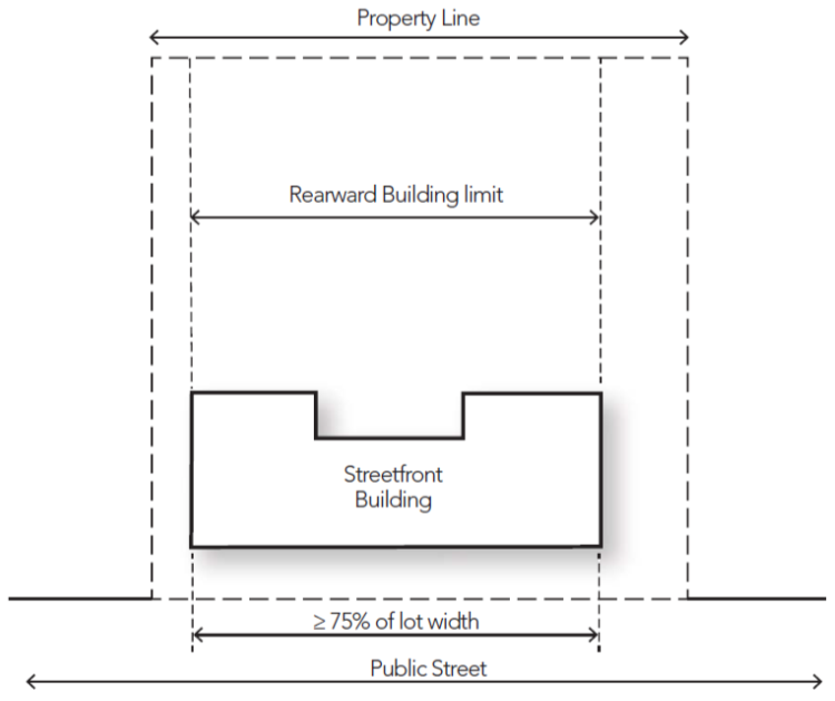
c. Deferral of Streetfront Buildings. Development of streetfront buildings may be deferred to allow construction of commercial or mixed use buildings to the rear of the site under the following provisions:
i. The deferral is to allow construction of commercial or mixed use buildings only; provided, that the entire ground floor footprint of the building is designed for commercial use.
ii. The site plan for the entire site includes streetfront buildings and associated parking, pedestrian areas, open space and landscaping as otherwise required under adopted development standards.
iii. An interim landscape plan shall be developed for the area of the site where streetfront buildings and associated improvements will later be installed. The landscaping shall be installed prior to occupancy of any buildings on the site and shall be retained until the site is developed for the approved streetfront buildings and associated improvements. At the applicant’s option, partial landscaping may be installed to at least include a manicured lawn area; provided, that financial security is posted to ensure completion of the interim landscape area per the approved landscape plan within three years of completion of the rearward building(s).
iv. Construction of buildings and improvements within the interim landscape area must commence per the approved site plan within three years of completion of the rearward buildings. If construction does not commence within the three-year period, the interim landscape area of the site shall convert to and be deemed an area of permanent landscaping and all remaining landscaping as otherwise deferred through financial securities shall be completed per the approved landscape plan. The landscape area may thereafter be developed only if a new site plan application is submitted and approved.
7. Twenty-foot setback only required on property lines adjoining single-family residential zones, otherwise no specific interior setback requirement. The 20-foot setback must be Type II landscape buffer as defined in NMC 18.16.040(B).
8. The minimum side setback in the MU-R zone is 10 feet.
9. Where the existing right-of-way is inadequate to allow for the required sidewalk widths, buildings must be set back the minimal distance in order to meet the required sidewalk width.
10. Within the CBC overlay zone, a FAR above 1:1 may only be achieved through the application of FAR incentives; see Chapter 18.36 NMC. Developments occurring within the MU-C and MU-R zones of the CBC overlay zone have a maximum FAR of 4:1 with the use of FAR incentives above a 1:1 FAR.
11. Applies only to shopping center subdistrict (SCS) as defined on official zoning map and as described in NMC 18.15.070(B).
12. Densities in the downtown core (DC) zone may be increased 10 percent for every 10 percent increase in commercial floor area ratio above 0.23, not to exceed 64 dwelling units per acre.
13. Reserved.
14. An upper story setback of 10 feet from the beginning of the building facade is required for any part of a building above the third story which abuts a public or private street.
15. Within the mixed use (MU), mixed use commercial (MU-C) and mixed use residential (MU-R) zones of the CBC overlay zone, there is an additional upper story setback for all new or expanded development above 35 feet and within 60 feet of single-family residential properties or Lake Boren. Starting at the required setback of 20 feet from the property line, building height may be increased 3.75 feet in height for every five feet of additional setback provided until the maximum height of 65 feet is not exceeded at the 60-foot setback.
16. The application of landscaping requirements contained in Chapter 18.16 NMC may restrict maximum hard surface coverage on some sites beyond the standards contained in this section. Hard surface coverage shall include the ground area of the entire development site covered by any impervious surface, permeable pavement, or vegetated roof, determined by extending a vertical projection to the ground from the widest points of any hard surface, and expressed as a percentage of total lot area.
17. Permitted Locations of FAR Incentives.
a. FAR incentives shall be used only on sites within the CBC overlay zone.
b. Cultural uses, as defined in NMC 18.08.040, shall be exempt from minimum and maximum FAR requirements.
18. Reserved.
19. The maximum impervious surface coverage may be exceeded up to the maximum hard surface coverage standard on sites where permeable surfaces are determined to be infeasible under the criteria identified in the city’s adopted surface water design manual.
20. Hard surface coverage and calculations are defined in NMC 18.06.298.5 (definition) and 18.06.298.6 (coverage calculation).
21. The vertical distance measured from the average finished grade to the highest point of a flat roof, or to mean height between the eaves and ridge of a pitched roof. Specifically excluded from this definition and from the regulation of maximum building height are structural elements not intended for habitation and not exceeding 10 feet above the maximum building height including structures housing or screening mechanical and elevator equipment, stairways, tanks, skylights, chimneys, smoke and ventilation stacks, mechanical and elevator equipment, and parapet walls designed solely to screen mechanical and elevator equipment. Also excluded from this definition and from the regulation of maximum building height are flag poles, church steeples, utility line towers and poles, and similar structures. (Ord. 2022-645 § 9; Ord. 2021-624 § 13; Ord. 2017-564 § 15; Ord. 2016-551 § 2 (Exh. 1); Ord. 2015-515 § 3 (Exh. A); Ord. 2011-443 § 3; Ord. 2009-403 § 4; Ord. 2008-392 § 4; Ord. 2008-380 § 2; Ord. 2007-364 § 2; Ord. 2005-311 § 1; Ord. 2003-274 § 1; Ord. 2001-239 § 13; Ord. 2000-210 § 26; Ord. 45 § 1, 1994; Ord. 18 § 1, 1994).
18.12.050 Measurement methods.
Repealed by Ord. 2000-210. (Ord. 45 § 1, 1994; Ord. 18 § 1, 1994).
18.12.060 Minimum urban residential density.
Minimum density for residential development in the urban areas designated by the comprehensive plan shall be based on the table in NMC 18.12.030, adjusted as provided for in NMC 18.12.070 and 18.12.080.
A. A proposal may be phased, when compliance with the minimum density requirement results in noncompliance with the standards of Chapter 18.28 NMC, provided the overall density of the proposal is consistent with this section.
B. Minimum density requirements may be waived by the city of Newcastle if the applicant demonstrates one or more of the following:
1. The proposed layout of the lots in a subdivision or the buildings in a multiple dwelling development will not preclude future residential development consistent with the minimum density of the zone.
2. The noncritical area of the parcel is of a size or configuration that results in lots which cannot meet the minimum dimensional requirements of the zone or in lots that result in an incompatible neighborhood design.
3. In the R-12 through R-24 zones, the area of the parcel required to accommodate stormwater facilities exceeds 10 percent of the area of the site.
4. The site contains a national, state or county historic landmark.
C. The minimum density requirements of NMC 18.12.030 shall be adjusted for the proportions of critical areas on the site, as follows:
|
Percentage of Site in Critical Area and/or Buffer |
Percentage Minimum Density |
|---|---|
|
1 – 20% |
90% |
|
21 – 40% |
80% |
|
41 – 60% |
60% |
|
61 – 80% |
40% |
|
81 – 100% |
20% |
Total dwelling units allowed by base density (prior to adjustment for critical areas and their buffers per NMC 18.12.080) x minimum density (NMC 18.12.030) x percentage of minimum density = adjusted minimum density.
(Ord. 2017-564 § 16; Ord. 2005-311 § 1; Ord. 2001-248 § 19; Ord. 2000-210 § 28; Ord. 45 § 1, 1994; Ord. 18 § 1, 1994)
18.12.070 Calculations – Allowable dwelling units or floor area.
Permitted number of units or floor area shall be determined as follows:
A. The maximum allowed number of dwelling units shall be computed by multiplying the site area (in acres) by the applicable residential density;
B. The allowed floor area which excludes structured or underground parking areas and mechanical equipment shall be computed by multiplying the project site area by the applicable floor/lot area ratio; and
C. When calculations result in a fraction, the fraction shall be rounded to the nearest whole number as follows:
1. Fractions of 0.50 or above shall be rounded up; and
2. Fractions below 0.50 shall be rounded down. (Ord. 2005-311 § 1; Ord. 45 § 1, 1994; Ord. 18 § 1, 1994).
18.12.080 Calculations – Site area used for density calculations.
A. All areas of a site may be used in the calculation of allowed residential density or project floor area subject to the adjustments for critical areas and their buffers set out in subsections (B) through (D) of this section.
B. Critical areas and their buffers may be used for calculation of allowed residential density whenever two or more residential lots or dwelling units are created subject to the following limitations:
1. Full density credit shall be allowed for coal mine, erosion and seismic hazard areas and for flood hazard areas outside of streams, wetlands or buffers associated with streams or wetlands.
2. Partial to full density credit shall be allowed for steep slopes, landslide hazard areas, and any required critical area buffers according to the following table:
|
Percentage of Site in Critical Area and/or Buffer |
Amount of Density Credit |
|---|---|
|
1 – 10% |
100% |
|
11 – 20% |
90% |
|
21 – 30% |
80% |
|
31 – 40% |
70% |
|
41 – 50% |
60% |
|
51 – 60% |
50% |
|
61 – 70% |
40% |
|
71 – 80% |
30% |
|
81 – 90% |
20% |
|
91 – 100% |
10% |
3. No density credit shall be allowed for streams or wetlands.
C. Allowed density on sites containing critical areas shall be calculated as follows:
1. Determine the percentage of site area in critical areas and buffers by dividing the total area in required critical areas and buffers by the total site area;
2. Multiply the density credit percentage set forth in subsection (B) of this section by the site area in critical areas and buffers to determine the effective critical area; and
3. Add the effective critical area to the site area not in critical areas or buffers. The resulting acres shall be considered the effective site area for purposes of density calculation and shall be treated the same as the site area for purposes of determining the allowable dwelling units pursuant to NMC 18.12.070.
D. Submerged lands except for artificially created ponds shall not be credited toward density or floor area calculations. (Ord. 2005-311 § 1; Ord. 2001-248 § 20; Ord. 98-176 § 2; Ord. 86 § 1, 1995; Ord. 45 § 1, 1994; Ord. 18 § 1, 1994).
18.12.090 Lot area – Prohibited reduction.
Any portion of a lot that was required to calculate and ensure compliance with the standards and regulations of this title shall not be subsequently subdivided or segregated from such lot. (Ord. 2005-311 § 1; Ord. 45 § 1, 1994; Ord. 18 § 1, 1994).
18.12.100 Lot area – Minimum lot area for construction.
Except as provided for nonconformances by Chapter 18.32 NMC:
A. No new lots shall be created in the R zone that contain less than the applicable minimum lot area shown in NMC 18.12.030.
B. Construction shall not be permitted in the R zone on an existing buildable lot of record containing less than 2,500 square feet or that is less than 30 feet in width. (Ord. 2005-311 § 1; Ord. 2000-210 § 29; Ord. 45 § 1, 1994; Ord. 18 § 1, 1994).
18.12.110 Setbacks – Specific building or use.
When a building, use or structure is required to maintain a specific setback from a property line or other building, such setback shall apply only to the specified building, use or structure. (Ord. 2005-311 § 1; Ord. 2001-248 § 21; Ord. 45 § 1, 1994; Ord. 18 § 1, 1994).
18.12.120 Setbacks – Modifications.
The following setback modifications are permitted:
A. When the common property line of two lots is covered by a building(s), the setbacks required by this chapter shall not apply along the common property line; and
B. When a lot is located between lots having nonconforming front setbacks, the required front setback for such lot may be the average of the two nonconforming setbacks or 60 percent of the required front setback, whichever results in the greater front setback. (Ord. 2005-311 § 1; Ord. 2000-210 § 30; Ord. 45 § 1, 1994; Ord. 18 § 1, 1994).
18.12.130 Setbacks – From regional utility corridors.
A. In subdivisions and short subdivisions, areas used as regional utility corridors shall be contained in separate tracts.
B. In other types of land development permits, easements shall be used to delineate such corridors.
C. All buildings and structures shall maintain a minimum distance of five feet from property or easement lines delineating the boundary of regional utility corridors, except for utility structures necessary to the operation of the utility corridor. (Ord. 2005-311 § 1; Ord. 45 § 1, 1994; Ord. 18 § 1, 1994).
18.12.140 Setbacks – From alley.
A. Structures may be built to the property line abutting an alley, except as provided in subsection (B) of this section.
B. Vehicle access points from garages, carports or fenced parking areas shall be set back from the alley property line to provide a straight line length of at least 26 feet from the access point to the opposite edge of the alley. No portion of the garage or the door in motion may cross the property line. (Ord. 2005-311 § 1; Ord. 45 § 1, 1994; Ord. 18 § 1, 1994).
18.12.150 Setbacks – Adjoining half-street or designated arterial.
In addition to providing the standard front setback, a lot adjoining a half-street or designated arterial, collector or local access street shall provide an additional width of front setback sufficient to accommodate construction of the planned half-street, arterial, collector or local access street. (Ord. 2005-311 § 1; Ord. 2001-248 § 22; Ord. 2000-210 § 31; Ord. 45 § 1, 1994; Ord. 18 § 1, 1994).
18.12.160 Setbacks – Projections allowed.
Projections may extend into required setbacks as follows:
A. Fireplace structures, bay or garden windows, enclosed stair landings, closets, or similar structures may project into any setback, provided such projections are:
1. Limited to two per facade;
2. Not wider than 10 feet; and
3. Not more than 24 inches into a side or rear setback or 30 inches into a front setback.
B. Uncovered porches and decks which exceed 18 inches above the finished grade may project:
1. Eighteen inches into side and rear setbacks; and
2. Five feet into the front setback.
C. Uncovered porches, patios and decks not exceeding 18 inches above the finished grade may project:
1. Eighteen inches into side setback; and
2. Fifteen feet into the rear setback; and
3. Five feet into the front setback.
D. Eaves may not project more than:
1. Eighteen inches into a side or rear setback; or
2. Twenty-four inches into a front setback.
E. Fences with a height of six feet or less may project into any setback; provided, that the sight distance requirements of NMC 18.12.200 are maintained.
F. Rockeries and retaining walls no more than six feet in height may project to the property line.
G. Accessory structures may be located in the rear building setback area in residential (R) zones provided the following are met:
1. The square footage of the accessory structure is less than the square footage threshold which would require a building permit for an accessory structure under the International Residential Code.
2. The accessory structure is no greater than 10 feet in height measured to the peak of the roof.
3. The placement of the accessory structure in the setback would not violate any standard or requirement of the city’s codes, including but not limited to impervious surface, building coverage, or critical areas.
4. The accessory structure has a minimum of five feet separation from any adjacent property line. Accessory structures may be placed less than five feet from an adjacent rear property line if the applicant has secured a written mutual agreement, in a format approved by the city, with the abutting property owners of the property lines affected. The agreement shall be recorded with the King County Division of Records and Elections and the applicant shall provide a copy of the recorded agreement to the city.
H. Waterfront structures, including but not limited to docks, piers, and floats, may project into required setbacks in aquatic areas in accordance with Chapter 18.17 NMC. (Ord. 2021-627 § 3; Ord. 2020-603 § 3; Ord. 2011-438 § 1; Ord. 2005-311 § 1; Ord. 2001-248 § 23; Ord. 2000-210 § 32; Ord. 45 § 1, 1994; Ord. 18 § 1, 1994).
18.12.170 Height – Exceptions to limits.
Repealed by Ord. 2000-210. (Ord. 45 § 1, 1994; Ord. 18 § 1, 1994).
18.12.180 Open space – Required in MU zones.
For new developments in MU, MU-C and MU-R zones, a minimum of 20 percent of the lot area shall be devoted to landscaping or pedestrian-oriented open space. (Ord. 2001-239 § 14).
18.12.190 Lot divided by zone boundary.
When a lot is divided by a zone boundary, the following rules shall apply:
A. When a lot contains both residential and nonresidential zoning, the zone boundary between the zones shall be considered a lot line for determining permitted building height and required setbacks on the site; and
B. Uses on each portion of the lot shall only be those permitted in each zone pursuant to Chapter 18.08 NMC. (Ord. 2001-248 § 24; Ord. 45 § 1, 1994; Ord. 18 § 1, 1994).
18.12.200 Sight distance requirements.
Except for utility poles and traffic control signs, the following sight distance provisions shall apply to all intersections and site access points:
A. A sight distance triangle area as determined by subsection (B) of this section shall contain no fence, berm, vegetation, on-site vehicle parking area, signs or other physical obstruction between 42 inches and eight feet above the existing street grade;
NOTE: The area of a sight distance triangle between 42 inches and eight feet above the existing street grade shall remain open.
SIGHT DISTANCE TRIANGLE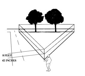
B. The sight distance triangle at:
1. A street intersection shall be determined by measuring 15 feet along both street property lines beginning at their point of intersection. The third side of the triangle shall be a line connecting the endpoints of the first two sides of the triangle; or
2. A site access point shall be determined by measuring 15 feet along the street lines and 15 feet along the edges of the driveway beginning at the respective points of intersection. The third side of each triangle shall be a line connecting the endpoints of the first two sides of each triangle.
C. The director may require modification or removal of structures or landscaping located in required street setbacks, if:
1. Such improvements prevent adequate sight distance to drivers entering or leaving a driveway; and
2. No reasonable driveway relocation alternative for an adjoining lot is feasible. (Ord. 2000-210 § 34; Ord. 97-153 § 39; Ord. 45 § 1, 1994; Ord. 18 § 1, 1994).
18.12.210 Nonresidential land uses in residential zones.
Except for utility facilities and uses listed in NMC 18.08.100, all nonresidential uses located in the R zone shall be subject to the following requirements:
A. Buildings and structures, except fences and wire or mesh backstops, shall not be closer than 30 feet to any property line, except as provided in subsection (B) of this section.
B. Single detached dwelling allowed as accessory to a church or school shall conform to the setback requirements of the zone.
C. Parking areas are permitted within the required setback area from property lines, provided such parking areas are located outside of the required landscape area.
D. Sites shall abut or be accessible from at least one public street functioning at a level consistent with city of Newcastle street design standards. New high school sites shall abut or be accessible from a public street functioning as an arterial per the city of Newcastle design standards.
E. The base height shall conform to height limitation of the zone in which the use is located. (Ord. 2000-210 § 35; Ord. 45 § 1, 1994; Ord. 18 § 1, 1994).