


Chapter 18.50
LOW IMPACT DEVELOPMENT DEMONSTRATION PROJECTS
Sections:
18.50.030 Low impact development.
18.50.050 LID demonstration projects – Established.
18.50.060 Review process, fees, deposits and other charges.
18.50.070 LID general standards.
18.50.080 Maintenance and education.
18.50.090 Streets and driveway standards.
18.50.100 Tree retention and protection.
18.50.120 Design, bulk and dimensional standards.
18.50.130 Clearing, grading, landscaping and integrated management practices (IMPs).
18.50.140 LID images and examples.
18.50.010 Purpose.
The city of North Bend is currently experiencing substantial growth. This growth will place demands on our community, transportation system, and ecosystems. As native landscapes transition into built environments, the infrastructure necessary to support the built environment will increase the impervious surface coverage as roads, parking areas, sidewalks and rooftops are constructed. These changes will reduce, disrupt or eliminate native vegetation, upper soil layers, shallow depressions, and drainage patterns that currently intercept, evaporate, store, slowly convey and infiltrate stormwater. In an effort to best maintain the existing quality of life and healthy natural environment, the city intends to guide new development and redevelopment towards environmentally and economically sustainable approaches. (Ord. 1610 § 1 (Exh. A (part)), 2016: Ord. 1366 § 1 (Exh. A (part)), 2009).
18.50.020 Definitions.
“Integrated management practices” are tools used in low impact development (LID) projects for water quality treatment and flow control. The controls are integrated throughout the project and provide a landscape amenity with a stormwater treatment and flow control function. These features are intended to mimic or model nature and the predevelopment hydrology.
“Rain garden” or “bioretention cell” means an engineered and vegetated small depression in ground that allows stormwater runoff directed from impervious areas such as roofs, streets, parking areas, sidewalks, driveways, walkways and compacted gravel areas to be treated and infiltrate near the source. Native plants are used within rain gardens because they are tolerant to local climate, soils and water conditions and do not require fertilizers. Water filters through engineered soil layers before entering the groundwater system (mimicking natural conditions). Plant and small tree root systems enhance infiltration, moisture redistribution and diverse microbial populations necessary for biofiltration. Rain gardens may or may not have an under-drain and are not designed as a conveyance system.
“Significant tree” means any evergreen tree of at least 15 inches DBH and any deciduous tree, other than red alder, holly, poplar and cottonwood trees, at least 12 inches DBH. Red alder, holly, poplar, cottonwood and other invasive trees of any size are not considered significant trees. (Ord. 1663 § 12, 2018: Ord. 1610 § 1 (Exh. A (part)), 2016: Ord. 1366 § 1 (Exh. A (part)), 2009).
18.50.030 Low impact development.
Low impact development (LID) is a stormwater management approach with a basic principle that is modeled after nature: manage rainfall and stormwater runoff at the source using decentralized small-scale controls. The goal of low impact development is to mimic a site’s predevelopment hydrology as much as practical by using design techniques that infiltrate, filter, store, recharge, evaporate, and detain runoff close to its source. Techniques are based on the premise that stormwater management should not be seen as stormwater disposal. Instead of capturing, conveying, managing and treating stormwater in large, costly end-of-pipe facilities, located at the bottom of drainage areas, LID addresses stormwater through small, cost-effective landscape features located at the lot and tract level. These landscape features, known as integrated management practices (IMPs), are the building blocks of LID. Almost all components of the urban environment have the potential to serve as an IMP. These include open spaces, rooftops, streetscapes, parking lots, sidewalks, landscape strips and medians. LID is a versatile approach that can be applied equally well to new development, urban retrofits, and redevelopment projects. The most suitable LID approaches may vary from site to site due to varying surface and sub-surface geology, topography, vegetation and site configuration. (Ord. 1610 § 1 (Exh. A (part)), 2016: Ord. 1366 § 1 (Exh. A (part)), 2009).
18.50.040 Benefits.
The benefits of low impact development include but are not limited to the following:
A. LID techniques protect the environment by removing pollutants from stormwater, reducing the overall volume of stormwater, managing high storm flows, and replenishing streams, wetlands and aquifers.
B. LID techniques help to reduce flooding and protect property. Reducing impervious surfaces, increasing vegetation, and dispersing and infiltrating stormwater result in less runoff. This reduces the likelihood of flooding from major storm events.
C. LID techniques help to protect human health by more effectively removing pollutants from stormwater. Untreated stormwater can be unsafe for people to drink or swim in.
D. LID techniques help to protect drinking water supplies by ensuring that rainfall infiltrates into the existing soils where it can recharge aquifers, rather than being treated as a waste and discharged to marine waters.
E. LID techniques provide cost-effective alternatives to systems upgrades. In many cases, LID systems, such as bioretention, are less expensive to use than costly stormwater vaults or land-consuming stormwater retention and storage ponds.
F. LID techniques improve the appearance and aesthetics of communities. LID projects leave more trees and plants and have less impervious surfaces, resulting in greener developments and communities.
G. LID techniques can increase public safety. One hallmark of LID is safer streets. Studies show that when vehicle traffic is slowed, there are fewer pedestrian accidents. LID techniques that serve to also slow traffic include narrower streets and integrated rain gardens doubling as traffic calming features.
H. LID techniques help to preserve a “green” and environmentally sustainable North Bend with a small town rural character. (Ord. 1610 § 1 (Exh. A (part)), 2016: Ord. 1366 § 1 (Exh. A (part)), 2009).
18.50.050 LID demonstration projects – Established.
In conjunction with all zoning requirements as set forth by the North Bend Municipal Code, there is hereby established a LID demonstration project provision. Due to the existing undisturbed mature significant forest located within the CLDR zoned property located north of SE 140th Street and east of the Wood River Subdivision, one LID demonstration project is allowed at this location, subject to the requirements set forth in this chapter. (Ord. 1610 § 1 (Exh. A (part)), 2016: Ord. 1366 § 1 (Exh. A (part)), 2009).
18.50.060 Review process, fees, deposits and other charges.
A. An applicant may apply for a conceptual LID demonstration project subject to the provisions set forth in this chapter. The conceptual LID demonstration project shall be an administrative approval made by the director of community and economic development. Once the applicant receives conceptual LID demonstration project approval, the applicant may submit a preliminary plat application, pursuant to NBMC Title 17 and subject to the conceptual LID demonstration project approval’s findings, conditions and project layout.
B. All applicable provisions of the North Bend Municipal Code shall stand in full effect for the conceptual LID demonstration project unless otherwise adjusted herein or approved by the city of North Bend as described in subsection C of this section.
C. If the city determines it necessary to waive any provisions of the NBMC to meet the goals and objectives of LID, the applicant must submit to the city a request in writing, identifying the code provision to be adjusted and clearly detailing the LID reasons and benefits for the alternative standard. The City shall approve, approve with condition, or deny the proposed adjustment with the conceptual LID demonstration project approval.
D. The applicant shall pay all costs associated with the review process as set forth in Chapter 20.09 NBMC. (Ord. 1610 § 1 (Exh. A (part)), 2016: Ord. 1366 § 1 (Exh. A (part)), 2009).
18.50.070 LID general standards.
The following LID standards and goals shall be achieved, unless otherwise approved by the city:
A. Stormwater Flow Control. Maintain and/or restore the predeveloped, undisturbed stormwater flow volumes, flow frequencies and durations, and water quality from a developed site. Stormwater discharges shall match developed discharge durations to predeveloped durations for the range of predeveloped discharge rates from 50 percent of the two-year peak flow up to the full 50-year peak flow. The flow control objectives can be achieved through the following site design objectives:
1. Conservation Measures.
a. Maximize retention of native forest cover and restore disturbed vegetation to intercept, evaporate and transpire precipitation. Leave a minimum of 35 percent of the total site area as open space retaining native soil and vegetation. This 35 percent requirement is in addition to sensitive areas and their buffers, and park requirements. Retain or restore native soils and vegetation on 45 percent of the developable site areas, not including road rights-of-way, trail rights-of-way and park areas. Where 45 percent is not reasonably achievable, the applicant shall demonstrate how the combined use of other LID techniques will achieve the overall goal.
b. Preserve permeable, native soil, and enhance disturbed soils to store and infiltrate storm flows.
c. Retain and incorporate topographic site features that slow, store, and infiltrate stormwater.
d. Retain and incorporate natural drainage features and patterns.
2. Site Planning Techniques.
a. Place structures on those portions of a site most suitable for development retaining sensitive lands or lands that can best provide stormwater functions as open space.
b. Locate structures, roads and other impervious surfaces in a manner to reduce adversely affecting significant trees, soils and other natural features that provide effective infiltration of stormwater and natural habitat.
c. Minimize total impervious surface area. Limit the effective impervious area of the total site area to no more than 27 percent.
3. Integrated Management Practices (IMP).
a. As appropriate for each site use: bioretention, pervious surfaces, rain gardens, open space surface water dispersion, soil restoration, rooftop infiltration, and other dispersed facilities to control stormwater as close to the origin as possible by utilizing small scale distributed hydrologic controls.
b. Create a hydrological landscape that slows storm flows and increases time of stormwater concentration.
c. Increase reliability of the stormwater management system by providing multiple LID flow control practices.
d. Integrate stormwater controls into the development design and utilize the controls as amenities. Create a multifunctional landscape.
e. Reduce the reliance on traditional conveyance and pond technologies. The use of traditional conveyance and pond technologies to manage stormwater quality and quantity should only be considered after all other LID techniques have been considered and used to the greatest extent possible.
f. Bioretention areas or rain gardens shall be shallow landscaped depressions and/or swales with a designed soil mix and plants adapted to the local climate and soil moisture. Landscaping with turf and/or sod in the bioretention areas should be used sparingly. To the extent practical, bioretention areas shall be integrated throughout the site to serve as landscape amenities and receive stormwater from small contributing areas.
g. General design requirements for all bioretention features or IMPs shall meet or exceed Chapter 6 of the Low Impact Development Technical Guidance Manual for Puget Sound and the most current best management practices.
h. Types of IMPs.
i. Rain gardens or bioretention cells are typically integrated into gardens on individual lots and tracts.
ii. Off-line bioretention swales incorporate the same design features as a rain garden or bioretention cell; however, bioretention swales are designed as part of a conveyance system and have relatively gentle side slopes. Contains a common flow entrance and flow exit, and the bioretention invert placed below the swale invert to provide the proper depth.
iii. In-line bioretention swales are hybrid facilities usually installed along roadways that incorporate bioretention cell and swale characteristics.
iv. Weep garden bioretention areas are used for steeper gradients where a retaining wall is used for structural support and for allowing storm flows directly to the facility to seep out.
v. Sloped bioretention-use vegetation barriers are designed for a specific hydraulic capacity, placed along sloped contours.
vi. Tree box filters are street tree plantings with an enlarged planting pit for additional storage, a storm flow inlet from the street, and an under-drain system.
vii. The diagram below shows the basic components of a bioretention cell. Final design features and details shall be reviewed and approved by the city.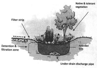
(Ord. 1610 § 1 (Exh. A (part)), 2016: Ord. 1366 § 1 (Exh. A (part)), 2009).
18.50.080 Maintenance and education.
A. A homeowners’ association shall develop a long-term maintenance program, to be reviewed and approved by the city prior to final plat approval, with clear and enforceable guidelines to best maintain the LID features of the plat. The applicant shall provide a guide that may be supplemented and distributed by the homeowners’ association to lot owners that explains the purpose and maintenance of the LIDs and IMPs within the plat.
B. A note(s) shall be placed on the face of each final plat that clearly describes and details the long-term maintenance requirements of the LID features of the plat and provides for guaranteed performance of said features. These requirements shall also be included in the neighborhood’s covenants, conditions and restrictions (CC&Rs), requiring proper assessments for maintenance and upkeep of said features. The final plat note shall be clear that in the event the homeowners’ association does not properly maintain said features, the City will perform the necessary maintenance and charge the homeowners’ association for time and expense of the maintenance work.
C. An educational packet and tree protection plan, which shall be reviewed and approved by the city of North Bend prior to final plat approval, and distributed, by the homeowners’ association, to all new homeowners explaining the hydrologic function and the long-term maintenance needs and requirements of the LID features. (Ord. 1610 § 1 (Exh. A (part)), 2016: Ord. 1366 § 1 (Exh. A (part)), 2009).
18.50.090 Streets and driveway standards.
A. Residential streets shall have a minimum width of a 20-foot drivable surface, with an at-grade 12-inch cement border and no parking allowed. Visitor parking shall be provided at a minimum of two spaces per acre in the form of pull-out areas along residential streets, so long as the 20-foot minimum travel width is provided. No more than two contiguous parking spaces shall be allowed. Any two contiguous parking spaces shall be separated by approximately 30 feet of Type II landscaping, tree preservation or biochannel. The internal street right-of-way shall be approximately 43 feet in width and include the following features: two 10-foot lanes, an at-grade 12-inch concrete border on both edges, a 12- to 15-foot landscaped functional biochannel, a six-foot asphalt paved meandering trail located behind the biochannel and tree preservation through the site and within the right-of-way when feasible. The width of the right-of-way may exceed 43 feet in an effort to include and preserve significant trees and meander the street through the trees. Pedestrian level down-lite full cutoff lighted bollards, to be maintained by the homeowners’ association, shall be provided along the trail to provide additional safety.
Street Design Sections for LID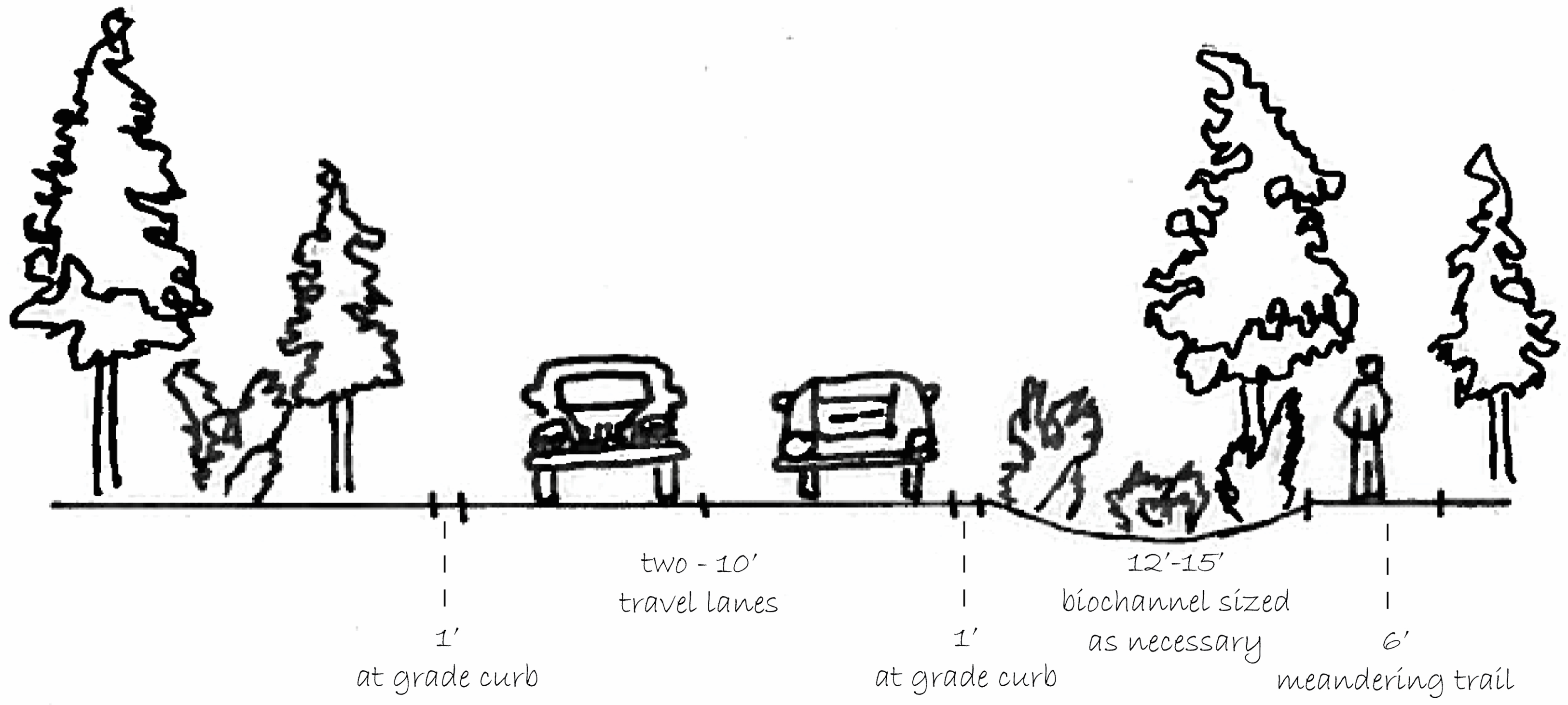
B. Internal circulation and road system shall be provided as generally shown in NBMC 18.50.140, Detail A, Site Development and Street Detail. Streets shall be curvilinear and meander through the development incorporating significant trees, natural features and vegetation where feasible and subject to compliance with emergency response needs. Given the street configuration, dead ends shall be avoided.
C. Residential streets shall be signed “no parking, fire lane” to ensure the 20-foot drivable area remains clear for emergency vehicles.
D. To preserve significant trees or valuable tree clusters, short one-way street sections should be integrated into the street design and plat layout where feasible. The width of one-way street sections shall be nine to 12 feet paved.
E. Street widths shall be designed to preserve a 28-foot inside turning radius and 48-foot outside turning radius for fire truck access. The actual fire truck radii will be confirmed upon review of the development application.
F. Whenever feasible, significant trees shall be retained and integrated into the roadway design; however, in no case shall the retention of tree canopy occupy the clear drivable area required for emergency vehicles of 18 feet in height and width.
G. The city shall own and maintain the paved street section. Subject to a maintenance agreement and annual schedule, the homeowners’ association shall maintain the gravel shoulders.
H. Driveway cuts shall be nine to 12 feet wide. Sixty-five percent of the driveways shall be constructed with a pervious material. Pervious materials allow rainwater to pass directly through the pavement and into the soil at an infiltration rate to be approved by the city engineer. Allowed materials, including gravel, shall meet this requirement. The homeowners’ association shall perform regular maintenance of the pervious driveway or otherwise require homeowner to conduct regular maintenance of their own driveway.
I. Signage shall be provided at each ingress and egress point of the plat establishing a speed limit of 15 miles per hour and indicating pedestrian use of roadways.
J. Frontage along SE 140th Street. A sidewalk in the form of a six-foot-wide asphalt paved pathway shall be provided along the frontage of the development along SE 140th Street in lieu of conventional curb/gutter/planter strip and sidewalk. The sidewalk shall meander within the right-of-way and through the significant tree retention buffer along SE 140th Street. Stormwater for SE 140th Street shall be accommodated via a separated landscaped biochannel, sized as necessary, and located between the edge of pavement and the significant tree retention buffer. The paved pathway may also be located partially or entirely within the SE 140th tree preservation buffer as described under NBMC 18.50.100(C). Pedestrian level down-lite full cutoff lighted bollards shall be provided along the trail to provide additional safety for children to walk to school. (Ord. 1610 § 1 (Exh. A (part)), 2016: Ord. 1366 § 1 (Exh. A (part)), 2009).
18.50.100 Tree retention and protection.
A. An average of 30 percent of all significant trees located within the developable area shall be retained. The developable area is considered areas where lots, roads and public infrastructure are located. Sensitive areas and their buffers, perimeter buffers and the buffer along SE 140 are not considered to be within the developable area. Thirty-three-one-hundredths significant tree credits will be given for every healthy well-located 12-foot or taller acceptable tree species up to the significant tree diameter threshold for trees established on the site. The retained and planted trees to satisfy the minimum 30 percent tree average shall be documented on a long-term tree plan for the site.
B. Significant tree stands shall be retained within the street right-of-way where feasible, subject to compliance with emergency response needs. Streets shall meander or split to avoid trees. Utility corridors must be identified and recognize the protection of retained trees. Methods for working near, over or under tree root systems must be described to protect these trees during construction.
C. Buffers. A tree preservation buffer of a minimum width of 30 feet shall be retained adjacent to the right-of-way of SE 140th Street and between said site and the adjacent Wood River neighborhood. These buffers shall be provided within a tract to be owned and maintained by the homeowners’ association of the development. The paved pathway that serves as the sidewalk along SE 140th Street may be located within this buffer, meandering through the trees, subject to a public use easement to the city of North Bend.
D. Significant trees may be limbed up or removed to allow for the below-listed activities. In no case shall the two remaining significant trees located on any one lot be removed. Trees removed for these purposes shall be replaced to maintain the 40 percent coverage in locations acceptable for the long term.
1. Solar access for rooftop solar panels;
2. Urban yard garden space.
E. Significant trees may be limbed up to 30 percent of the tree height, thinned for windfall management and light, and dead or dangerous limbs removed in accordance with removal specifications from a certified arborist. Any tree that must be removed for any reason that exceeds the maximum allowed number of trees to remove, shall be replaced with three 12-foot conifers (DSH), planted on the lot, near the lot or in the plat to contribute and maintain the minimum tree cover canopy. City arborist shall approve and confirm planting. A bond and three-year warranty is required on any planting.
F. The homeowners’ association shall contract with a certified arborist for ongoing tree care of the entire neighborhood including trees located on the private lots, open spaces, critical areas and public rights-of-way. A tree removal permit shall be submitted to the city for review and approval prior to removal of any tree. The information submitted with the tree removal permit shall reference the tree protection plan and confirm the retention and maintenance of the required tree cover. All pruning shall be done in accordance with ANSI standards.
G. To the maximum degree practicable, the tree canopy over the entire site shall remain a minimum of 40 percent site area coverage in perpetuity. Supplemental plantings may be required over time. A tree protection plan, produced by the homeowners’ association, shall annually confirm a record of the retained trees and propose additional plantings to maintain the 40 percent canopy coverage required on the whole site.
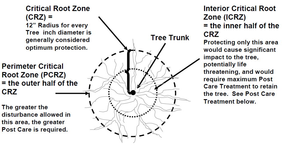
H. Any clearing, grading and construction on any lot and the whole site overall shall require a tree protection plan (TPP) specific to that area or lot and the trees on it. The TPP shall identify all protected trees and all work proposed around and near those trees. The TPP shall describe all methods of tree protection that are proposed to mitigate for the work to be done on site. The developer shall hire a certified arborist to provide this plan, review implementation and to be on site during work within the interior critical root zone (CRZ). The developer’s certified arborist shall have this plan approved by the city’s certified arborist. The city’s arborist shall review, approve and monitor the work to confirm that tree protection methods are being followed.
1. Soil compaction shall not be allowed over any interior critical root zone and limited access over the perimeter CRZs. As a general guideline, the tree critical root zone shall be defined as an area equal to a one-foot radius for every one inch trunk diameter at standard height (DSH). “DSH” means the diameter at standard height; the diameter of the trunk measured 54 inches (four and one-half feet) above grade. See detail below for an explanation of the CRZ. The entire CRZ is divided in half with the outside 50 percent of the CRZ described as the perimeter CRZ and the inside 50 percent of the CRZ as the interior CRZ. At all times, the interior CRZ shall be retained without disturbance and protected from soil compaction with woodchips and/or steel plates. Any intrusion into the interior CRZ shall be approved and monitored by the city arborist. Work within the perimeter CRZ is allowed with limitations and protection.
I. Removal of any significant tree shall require a permit issued by the city of North Bend. Applications for tree removal must comply with the standards found in this chapter and Chapter 19.10 NBMC. In the event of a conflicting standard, the more stringent shall apply. (Ord. 1610 § 1 (Exh. A (part)), 2016: Ord. 1366 § 1 (Exh. A (part)), 2009).
18.50.110 Parks and trails.
A. Trails shall be an integral part of the development allowing for pedestrian connectivity and recreational opportunities. Trails should perform similar to the sidewalk providing for safe, well-connected pedestrian routes throughout the neighborhood. Trails shall be provided as generally shown in NBMC 18.50.140, Detail A, Site Development and Street Detail.
B. A five-foot-wide meandering trail shall be provided within the buffer areas located between the site and the adjacent Wood River neighborhood extending from SE 140th Street to the Snoqualmie Middle Fork River to provide public access opportunity to the river. Additional five-foot-wide trail connections shall be provided through the site to the Snoqualmie Middle Fork River as generally provided in Detail A in NBMC 18.50.140. A cedar split-rail fence shall be provided along the west property line adjacent to the Wood River and Miners Ridge neighborhoods.
C. Allow trail access throughout the site for human interaction with the natural environment. Trails may cross into and through critical areas and buffers upon receipt of applicable regulatory approvals to provide for an integrated trail system and to access noncritical open space areas. All trails located within a critical area buffer shall comply with NBMC Title 14, Environmental Protection.
D. Trail surface shall be constructed of crushed rock at a minimum of six inches in depth. Soft-surface materials (hog fuel) may be utilized in place of crushed rock as approved by the community and economic development director, depending on the site and trail characteristics and anticipated trail usage. All trails within critical area buffers shall be provided with soft-surface material.
E. Chapter 17.25 NBMC, Residential Recreation and Common Space Requirements, shall be met, unless otherwise adjusted herein or otherwise waived by the city of North Bend. Recreational spaces, as required by Chapter 17.25 NBMC, may be allowed to be located in areas of the development not directly adjacent to public streets, so long as access is provided by a street or trail and natural significant features are incorporated into the recreational area such as tree groves, wetland viewing, vistas or other natural features. In order to encourage the retention of significant trees and to minimize site grading, requirements to provide mini-parks or consolidated parks may be met by providing open space improved with trails, seating, educational interpretive signage, picnic areas, pea patches and other related amenities intended to provide enjoyment of the natural features of the site, so long as that portion of the total area of open space, trails and amenities located in otherwise developable area equals the minimum size of mini-parks and consolidated parks for the property. This requirement is in addition to the 35 percent open space provision established in NBMC 18.50.070(A)(1) and shall not include the buffer area along 140th Street, the buffer area between this site and Wood River or sensitive areas and their buffers. (Ord. 1610 § 1 (Exh. A (part)), 2016: Ord. 1366 § 1 (Exh. A (part)), 2009).
18.50.120 Design, bulk and dimensional standards.
A. The overall gross density shall not exceed two dwelling units per acre with a minimum lot size of 18,000 square feet.
B. The placement of structures on the lots shall take into consideration the location and retention of significant trees. The LID demonstration preliminary plat application shall include a structure placement plan, which shall clearly identify the significant trees to be retained on each lot and the buildable area of each lot.
C. Where feasible, orient the long axis of the structure along topographic contours to reduce cutting and filling.
D. Where feasible, control roof water within the lot with rain gardens, infiltration trenches, dispersion systems and other IMPs.
E. Use low impact foundations, including but not limited to step foundation, pin foundation, requiring minimal excavation where feasible.
F. Retaining walls shall be kept to a minimum height, not exceeding approximately four and one-half feet in height. (Ord. 1610 § 1 (Exh. A (part)), 2016: Ord. 1366 § 1 (Exh. A (part)), 2009).
18.50.130 Clearing, grading, landscaping and integrated management practices (IMPs).
A. Limit clearing and grading to road, trail, parking, utility, building pad, park areas and areas required for storing and blending excavation topsoil and mulch and for construction staging. All other land area should be delineated and protected from compaction with construction fencing.
B. Limit construction access to where future roads and utility corridors will be placed to the extent reasonably feasible.
C. Limit overall project cut and fill through efficient road design and lot layout.
D. Retain natural topographic features that slow and store storm flows.
E. Retaining native soil and vegetation is a primary objective.
F. Stockpile and reuse excavated topsoil to amend disturbed areas.
G. The clearing limits shall be clearly flagged and signed.
H. Once the clearing limits are clearly flagged and signed, the equipment operators shall walk the site with the city engineer or his/her designee.
I. All disturbed areas shall be restored and revegetated to meet NBMC 18.18.080, Type 2 landscaping, or as otherwise approved by the city. (Ord. 1610 § 1 (Exh. A (part)), 2016: Ord. 1366 § 1 (Exh. A (part)), 2009).
18.50.140 LID images and examples.
A. Site Development and Street Detail.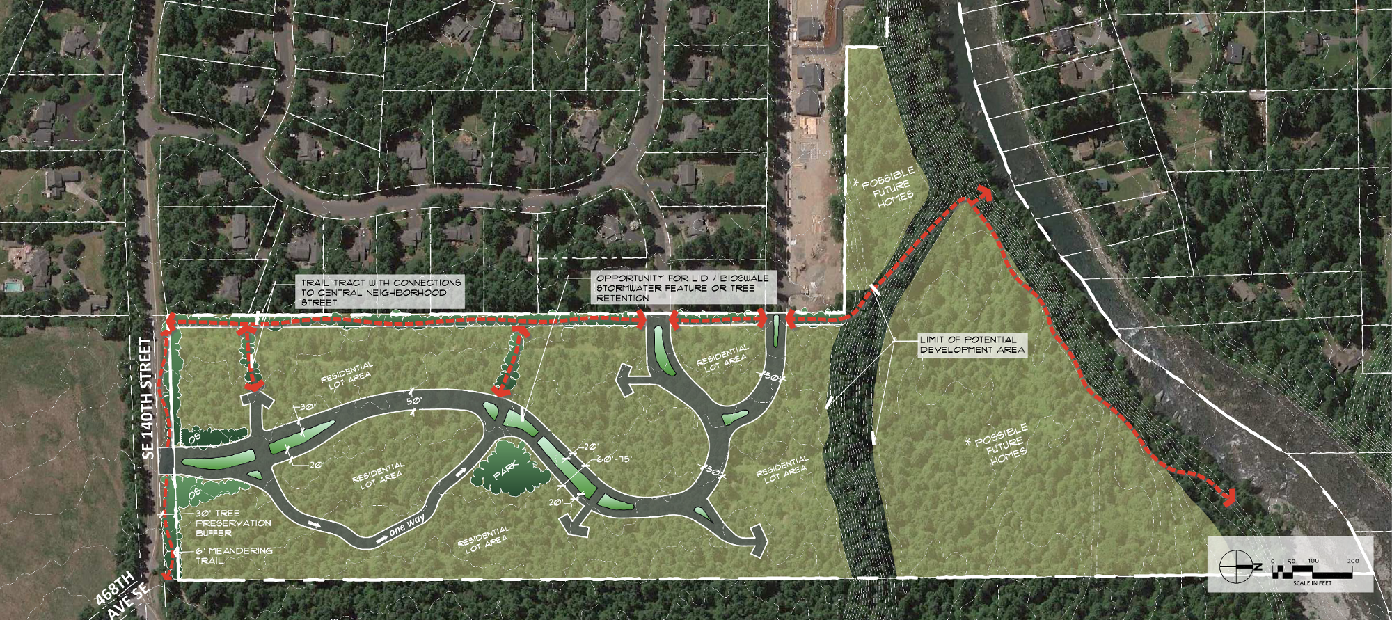
B. Use of Native Vegetation and Pervious Pavers.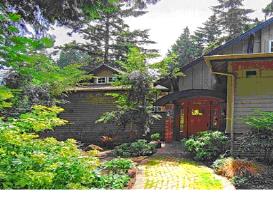
C. Beaux Arts – Residential Streetscape Example. Tree preservation, narrow winding streets and integrated significant trees/vegetation.
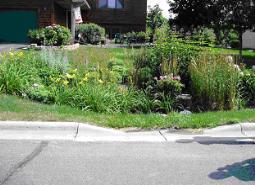
D. Residential Lot with Integrated IMPs/Rain Gardens.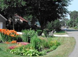
(Ord. 1610 § 1 (Exh. A (part)), 2016: Ord. 1366 § 1 (Exh. A (part)), 2009).