


20D.42.50 Identification of Citywide Public View Corridors.
Map 20D.42.50 shall identify areas from which there are significant views from public spaces. Each area identified will correspond to a more detailed map/diagram and a narrative description that may be supplemented with photos/diagrams of the views to be preserved together with design guidelines to be used to protect that particular view.
(Ord. 2340)
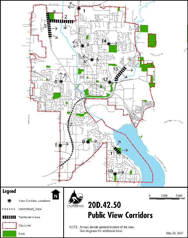
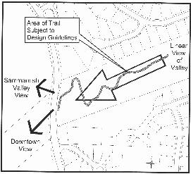
20D.42.50-010 View 1, Territorial View of the Sammamish Valley from Redmond-Woodinville Road Looking Northwest.
(1) Description of View to Be Protected. Territorial view of the open farmlands of the Sammamish Valley, including several parcels permanently protected as farmlands. Distant ridgelines enclose this view.
(2) Improvements to portions of Redmond-Woodinville Road from NE 124th Avenue south for four blocks shall avoid the use of sight-obstructing guardrails or barriers along the western side of Redmond-Woodinville Road. Landscape materials shall not consist of hedges or street trees that would obscure entire lengths of the public view corridor and generally are discouraged. Low-lying plant materials are encouraged. If taller plant materials are used, they shall be clustered and clusters widely spaced to provide for continuous views to the Sammamish Valley.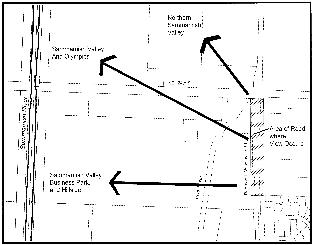
View 1. Area of Road Subject to Design Guidelines
(Ord. 2340)
20D.42.50-020 View 2, Territorial View of the Sammamish Valley Along NE 116th Road.
(1) Description of View to Be Protected. A territorial view of the Sammamish Valley and Mt. Rainier can be seen along NE 116th Street from Willows Road to the York Bridge.
(2) Solid fencing, solid hedges or rows of trees will not be allowed south of NE 116th Street in the Urban Recreational zone if the fencing or the height of the landscaping at mature growth would block views of the Sammamish Valley or of Mt. Rainier. The use of street trees or median dividers with hedges for roadway improvements shall not be allowed.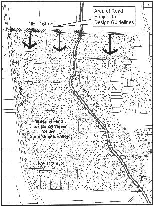
View 2. Shading Illustrates Area Subject to Design Guidelines
(Ord. 2340)
20D.42.50-030 View 3, Territorial View of the Sammamish Valley Along Willows Road.
(1) Description of View to Be Protected. A territorial view of the Sammamish Valley with distant ridgelines of Education Hill in the background, and a view of Mt. Rainier can be seen along Willows Road from just north of the Willows Run Golf Course complex to the City limit.
(2) Solid fencing, solid hedges or rows of trees will not be allowed along the east edge of Willows Road or along property lines between the road and the Sammamish River. The use of street trees on the eastern edge or median dividers with hedges for roadway improvements shall not be allowed.
View 3. Shading Illustrates Area Subject to Design Guidelines
(Ord. 2340)
20D.42.50-040 View 4, Puget Power Trail to Sammamish Valley.
(1) Description of View to Be Protected. Views are of the Sammamish Valley and the west ridgeline above the Sammamish Valley, beginning as one descends the trail on the Puget Power right-of-way almost to Redmond-Woodinville Road.
(2) Trail fencing in this public view corridor should be kept to a minimum, be built low when feasible, use natural or natural-looking materials and colors, and use fence types such as post and rail or split rail.
View 4. Puget Power Trail Section
(Ord. 2340)
20D.42.50-050 View 5, Reservoir Park.
(1) Description of View to Be Protected. This view is a territorial view of the Sammamish Valley and distant ridgelines of Northeast Rose Hill from the Downtown to the northern border of the city from Reservoir Park. There are some interdispersed trees, both conifer and deciduous, that break the ridgelines but do not obstruct the primary view.
(2) Solid fencing, solid hedges or rows of trees should be avoided where they would obstruct views of the Sammamish Valley. Avoid planting evergreen trees or trees with broad canopies in areas of the park where they would occlude major portions of the view.
View 5. Shading Illustrates Area Subject to Design Guidelines
(Ord. 2340)
20D.42.50-060 View 6, Downtown and Sammamish Valley from 148th Avenue NE.
(1) Description of View to Be Protected. Beginning approximately 500 feet south of the Redmond Way intersection, views of the Sammamish Valley and distant mountains are evident. Near the intersection, the details of Downtown development patterns become apparent. From the point north of Redmond Way, views are to the north and northeast to about halfway to the bottom of the hill.
(2) Solid fencing, solid hedges or rows of trees will not be allowed where they would obstruct views out to the Sammamish Valley or Downtown. Signage located in this public view corridor shall be designed to minimize view obstruction.
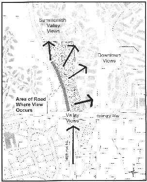
View 6. Shading Illustrates Area Subject to Design Guidelines
(Ord. 2340)
20D.42.50-070 View 7, Views Along the SR 520 Corridor.
(1) Description of View to Be Protected. Southbound, the SR 520 corridor has framed views of Mt. Rainier and northbound presents territorial views of Downtown Redmond, Marymoor Park, and the Cascade Mountain Range.
(2) Transportation projects that involve structures, such as sound walls, bridges, or the addition of high-capacity transit, shall submit an analysis for plan review of potential view obstruction and the possible means to mitigate this obstruction. Design proposals shall not call for complete obstruction of identified views unless it can be demonstrated that there is no reasonable alternative. (Ord. 2340)
20D.42.50-080 View 8, Cascade Range from Section of 148th Avenue NE Along Microsoft Lakeridge.
(1) Description of View to Be Protected. Views of the Cascade Range can be seen from 148th Avenue NE along the main entrance between buildings of the Microsoft Lakeridge development.
(2) New development shall maintain no less than 30 percent of the existing view corridor. It is preferable if an open space corridor is maintained although modulation of building heights may be used such that the mountains can be seen over lower sections of structures. Solid fencing or solid landscaping that will immediately or upon reaching maturity obscure views of the Cascade Range will not be allowed in this view corridor. Type III landscaping shall be the preferred landscaping in the view corridor.
View 8 – Figure 1. View of Cascade Range from 148th Avenue NE
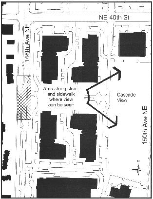
View 8 – Figure 2. Shading Illustrates Area Subject to Design Guidelines
(Ord. 2340)
20D.42.50-090 View 9, Cascade View Park and NE 40th Street.
(1) Description of View to Be Protected. There are Cascade views from the north side of NE 40th Street and from locations within the Cascade View Park directly east from some vantages and to the northeast from others.
(2) Solid fencing, solid hedges or rows of trees should be avoided where they would obstruct views across those portions of the park where the Cascade Range can be seen. Any additional structures, signs, or landscaping in the park should be designed to protect these views.
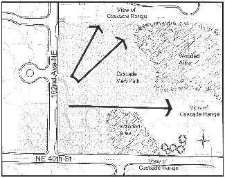
View 9. Cascade Park View Corridor Locations
(Ord. 2340)
20D.42.50-100 View 10, NE 24th Street and Viewpoint Open Space Park.
(1) Description of View to Be Protected. From the top of the hill and from points entering the trail in the Viewpoint Open Space Park, views of the Sammamish Plateau and a very distant view of the Cascades are visible. From the trail the views are filtered but not completely obstructed by trees and vegetation.
(2) The addition of signage along NE 24th Street that would obstruct views should be avoided. To enhance views from the Viewpoint Open Space Park, blackberry and nonnative vegetation removal should be encouraged, and replacement should be with native species that would maintain existing framed or filtered views from the park.
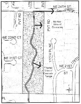
View 10. Viewpoint Open Space Primary View Locations
(Ord. 2340)
20D.42.50-110 View 11, Lake Sammamish Along Idylwood Park.
(1) Description of View to Be Protected. Views are of Lake Sammamish from West Lake Sammamish Parkway alongside Idylwood Park. Views are from the sidewalk, bike lanes, and the roadway. Views are through existing vegetation and are more open on the northern half of the park.
(2) Road projects along the eastern edge of West Lake Sammamish Parkway shall not include sight-obscuring objects such as fencing or hedge-like landscaping. This treatment should be avoided within the park as well, and any additional structures, signs, or landscaping within the park should be designed to protect views to the lake. Development along this stretch of the corridor additionally shall follow the shoreline view regulations.
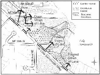
View 11. Idylwood Park View Corridor Locations
(Ord. 2340)
20D.42.50-120 View 12, Bear/Evans Creek Valley/Cascade Range from NE 80th Street and 172nd Avenue NE.
(1) Description of View to Be Protected. Where NE 80th Street curves north to turn into 172nd Avenue NE, a narrow public view corridor exists, following the existing electric lines, that overlooks the business park area; however, the primary view is of the Bear/Evans Creek Valley and to distant mountain peaks. The corridor extends nearly to Avondale Way.
(2) Maintain the right-of-way/utility corridor for potential pedestrian use. Trail enhancements could create additional accessibility for the public to this view corridor. Undergrounding of utility lines would also enhance this view.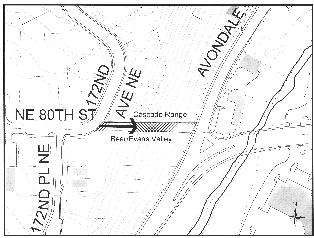
View 12. Shading Illustrates Area Subject to Design Guidelines
(Ord. 2340)
20D.42.50-130 View 13, Bear/Evans Creek Valley.
(1) Description of View to Be Protected. Pastoral views of the Bear/Evans Creek Valley towards the east of the Bear/Evans Creek Valley extend nearly a half-mile along a stretch of Avondale Road just below the entrance to the Ashford Park Condominiums to just short of the Bear Creek crossing. The view is currently almost unobstructed with only a handful of single-family structures in the northern stretch.
(2) Sight-obscuring fencing will not be allowed along Avondale Road anywhere between the road and Bear/Evans Creek. Fences such as split rail would be allowed. New development will avoid sight-obscuring, tall hedge-like landscaping. Development along this stretch of the corridor additionally shall follow the shoreline view regulations.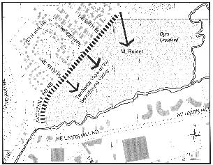
View 13. Shading Illustrates Area Subject to Design Guidelines
(Ord. 2340)
20D.42.50-140 View 14, Cascade Range from 172nd Avenue NE Trail.
(1) Description of View to Be Protected. A panoramic view of the Cascade Range can be seen perpendicular to the trail corridor along the southern portion of the Redmond High School athletic field. The winter view is more open because the foliage is deciduous; however, the trees are spaced to provide views between them. There is a section of the trail between the end of the track to the bleachers (approximately 150 feet of trail frontage from NE 104th Street to the north) where the view is unimpaired by either landscaping or structures.
(2) Ensure that any structures such as additional seating built in this public view corridor would allow views out over or through them. Fences high enough to be in the line of sight are strongly discouraged. Fences, if constructed, shall not be constructed of sight-obstructing materials and shall be constructed of materials that allow views through them. Any additional landscaping placed within 25 feet of the east portion of the trail along this section shall be Type III or IV plant materials except that additional trees shall be prohibited. Blackberry removal along the existing fence is encouraged to prevent encroachment into the view. 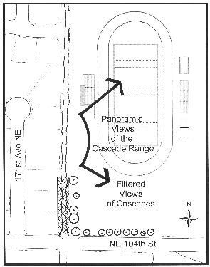
View 14. 172nd Trail View Corridor Locations
(Ord. 2340)
20D.42.50-150 View 15, Cascade Range from Westside Neighborhood Park and from NE 57th Street.
(1) Description of View to Be Protected. A panoramic view of the Cascade Range can be seen from several locations within Westside Neighborhood Park as well as from NE 57th Street, east of 156th Avenue NE. The winter view is more open because the foliage is deciduous. However, existing tree locations and the easterly, downward slope of the park support mountain views. In particular, the most western portion of the park provides the most viewing opportunities.
(2) Ensure that any structures built in this public view corridor allow views out, over or through them. Fences are strongly discouraged. Fences, if constructed, shall be sighted to minimize view obstruction and shall be designed and constructed of non-sight-obstructing materials that allow views through them. As needed or required, replacement of existing vegetation should occur using similar or site-appropriate species located in similar manner to maintain staggered viewing opportunities. Any additional landscaping shall be Type III or IV plant materials.
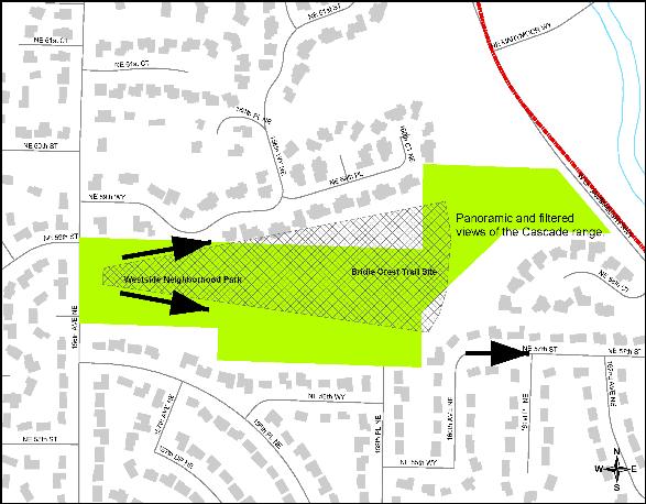
View 15: Views of Cascade Range from Westside Neighborhood Park and NE 57th Street
(Ord. 2540)