


4-11-120 DEFINITIONS L:
LABORATORIES, LIGHT MANUFACTURING: A facility in which scientific research, investigation, testing, or experimentation occur. Manufacturing of and sale of products may also occur.
LABORATORIES, RESEARCH, DEVELOPMENT AND TESTING: A facility in which scientific research, investigation, testing, or experimentation occur but not including manufacture and sale of products.
LAKES: Natural or artificial bodies of water of two (2) or more acres and/or where the deepest part of the basin at low water exceeds two (2) meters (6.6 feet). Artificial bodies of water with a recirculation system approved by the Planning/Building/Public Works Department are not included in this definition.
LAND CLEARING: The act of removing or destroying trees or ground cover including grubbing of stumps and root mat.
LAND-CLEARING WASTE: Stumps, brush, tree branches, and other vegetation associated with land clearing.
LAND DEVELOPMENT PERMIT: An approved preliminary or final plat for single-family residential project, a building permit, civil construction permit, site plan, or preliminary or final planned urban development plan.
LAND USE DECISION: A land use decision for purposes of a land use appeal under RMC 4-8-110, Appeals, means a final determination by a City body or officer with the highest level of authority to make the determination, including those with authority to hear appeals on:
1. An application for a project permit or other governmental approval required by law before real property may be improved, developed, modified, sold, transferred or used, but excluding applications for permits or approvals to use, vacate, or transfer streets, parks, and other similar types of public property; excluding applications for legislative approval such as area-wide rezones and annexations; and excluding applications for business licenses;
2. An interpretive or declaratory decision regarding the application to a specific property of zoning or other ordinances or rules regulating the improvement, development, modification, maintenance, or use of real property;
3. The enforcement by the City of codes regulating improvement, development, modification, maintenance or use of real property. However, when the City is required by law to enforce the code in a court of limited jurisdiction, a petition may not be brought under RMC 4-8-110.
LAND USE ELEMENT: A plan designating the location and extent of use for agriculture, timber production, housing, commerce, industry, recreation, open spaces, public utilities, public facilities, and other land uses as required by the Growth Management Act.
LANDFILL: Addition of soil, sand, rock, gravel, sediment, earth retaining structure, or other material to an area waterward of the OHWM, in wetlands, or on shorelands, in a manner that raises the elevation or creates dry land.
LANDS COVERED BY WATER: Lands underlying the water areas of the state below the ordinary high water mark, including salt waters, tidal waters, estuarine waters, natural watercourses, lakes, ponds, artificially impounded waters, marshes, and swamps.
LANDSCAPE ARCHITECT: A professional landscape architect licensed to practice by the State of Washington.
LANDSCAPE BUFFER: An on-site strip abutting a property line which provides a physical, visual, and/or noise buffer and transition between land use of varying compatibilities and/or the street. Landscape buffers consist primarily of natural landscaping and selected hard surface elements, when deemed appropriate by the Community and Economic Development Administrator or Hearing Examiner.
LANDSCAPED VISUAL BARRIER: Evergreen trees, and/or evergreen shrubs providing equivalent buffering, planted to provide a year-round dense screen within three (3) years from the time of planting.
LANDSCAPING: The installation of lawns, trees, shrubs, flowers, ground cover and similar items to enhance a property’s attractiveness, prevent erosion, improve security or for similar purposes.
LICENSED ENGINEER: A professional engineer, licensed to practice in the State of Washington.
LID BEST MANAGEMENT PRACTICES: LID best management practices are referred to as BMPs. LID BMPs are distributed stormwater management practices, integrated into a project design, that emphasize pre-disturbance hydrologic processes of infiltration, filtration, storage, evaporation and transpiration. LID structural BMPs are referred to as flow control BMPs and include, but are not limited to, bioretention, permeable pavements, roof downspout controls, dispersion, soil quality and depth, and minimal excavation foundations (pursuant to the Surface Water Design Manual).
LIGHT DEFINITIONS: The following definitions are utilized in the Exterior Onsite Lighting Regulations, RMC 4-4-075, and/or the Urban Design Guidelines, RMC 4-3-100:
A. Cutoff: The point at which all light rays emitted by a light source are completely eliminated (cut off) at a specific angle above the ground.
B. Cutoff Angle: The angle formed by a line drawn from the direction of light rays at the light source and a line perpendicular to the ground from the light source, above which no light is emitted.
C. Cutoff Type Luminaire: A unit of illumination with elements such as shields, reflectors, or refractor panels that direct and cut off the light at a cutoff angle less than ninety degrees (90°).
D. Downlighting: A direct lighting unit that aims the light downward. Downlighting is glare-free and shielded from the sky and adjacent and abutting properties, either through exterior shields and/or through optics within the fixture.
E. Light Trespass: The shining of light produced by a light source beyond the boundaries of the property on which it is located.
F. Luminaire: The complete lighting unit, including the lamp, the fixture, and other parts.
LIVE-WORK UNIT: A structure or portion of a structure that combines a commercial activity with a residential living space where there is an internal connection between the living and working spaces within the unit. The nonresidential portion of the unit must meet commercial building standards.
LOADING AREA: A specially designed off-street place intended to be used by vehicles for depositing and/or receiving passengers and goods.
LOCAL SERVICE UTILITIES: Public or private utilities normally servicing a neighborhood or defined subarea in the City, i.e., telephone exchanges; sanitary sewer, stormwater facilities; distribution lines, electrical less than fifty five (55) kv, telephone, cable TV, etc.
LONG-RANGE WASTEWATER MANAGEMENT PLAN: See RMC 4-6-100.
LOT: A physically separate and distinct property that has been created pursuant to the provisions of this title, or pursuant to any previous laws governing the subdivision, short subdivision, or segregation of land. This definition excludes tracts and parcels. See LOT TYPES.
LOT COMBINATION: The merger or aggregation of lots via either:
1. The construction of a dwelling unit upon a lot line shared by an abutting lot under common ownership at the time of construction; provided, that upon removal of the dwelling unit, proof that each lot was legally created and that the original lots comply with the current minimum lot size, width, and depth requirements of the applicable zone, the original lots may be recognized as being segregated; or
2. A request by the property owner for a permanent merger of two (2) or more lots by the completion, approval and subsequent recording of a Declaration of Lot Combination or Lot Line Adjustment.
LOT COVERAGE: The percentage of the lot area covered by principal and accessory buildings as projected on a horizontal plane. The lot coverage calculation shall include the area enclosed by the exterior walls of a building or accessory building, including all covered decks, porches and stairs. Where lot coverage is referenced, refer to the applicable building coverage standards. Should any conflict result, the Administrator shall determine the effective code.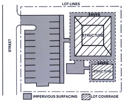
(Ord. 6184, 2-23-2026)
LOT, DEVELOPED: (This definition for RMC 4-4-130, Tree Cutting and Land Clearing Regulations, only.) A lot or parcel of land upon which a structure(s) is located, which cannot be more intensely developed pursuant to the City Zoning Code, and which cannot be further subdivided pursuant to City subdivision regulations.
LOT, LEGAL: A lot, which is not necessarily a buildable or developable site, created in compliance with any applicable State and local laws in effect at the time, as cited below, and subject to the following:
A. The lot was created before June 9, 1937, and it was served by at least one (1) of the following before January 1, 2000:
1. Approved sewage disposal;
2. An approved water system; or
3. A road that was:
a. Accepted for maintenance by the King County Department of Transportation; or
b. Located within an access easement for residential use or in a road right-of-way and consists of a smooth driving surface, including, but not limited to, asphalt, concrete, or compact gravel, that complied with the King County road standards in effect at the time the road was constructed.
B. Between March 17, 1937, and July 22, 1958, dates inclusive, the lot was created in compliance with State segregation statutes and County codes; or
C. The lot was created after July 22, 1958, through a review and approval process of the City, County, or State for the creation of two (2) or more lots or through a process recognized as exempt from platting by State law.
D. The lot was created before October 1, 1972, and:
1. Conveyed as an individually described parcel to separate, noncontiguous ownerships through a fee simple transfer or purchase; or
2. Recognized as a separate tax lot by the County Assessor.
E. The lot was created on or after October 1, 1972, and:
1. Through the subdivision or short subdivision process; or
2. Through the following alternative means of lot segregation provided for by State statute or County code:
a. At a size twenty (20) acres or greater, created by a record of survey recorded before January 1, 2000, and not subsequently merged into a larger lot;
b. At a size forty (40) acres or greater created through a larger lot segregation made in accordance with RCW 58.18.010, Assessor’s plat – Requisites, filing, index, etc. – When official plat, approved by King County and not subsequently merged into a larger lot;
c. Through testamentary provisions or the laws of descent after August 10, 1969;
d. As a result of deeding land to a public body after April 3, 1977;
F. Each portion of a legal lot created through a process described above subsequently split by a right-of-way under threat of condemnation shall be considered a legal lot.
LOT LINE ADJUSTMENT: The alteration of common lot line(s) between abutting legal lots, tracts, or parcels for the purpose of accommodating a transfer of land to rectify a disputed property line location, combine lots, or free such a boundary from any difference or discrepancies without creating additional lots, tracts or parcels.
LOT LINES: The property lines bounding a lot; the designation of lot lines (front, rear, and side) shall be based on the yard designations (see YARD REQUIREMENT).
LOT MEASUREMENTS:
A. Lot Depth: Except for lots abutting a shoreline of the State, lot depth shall be the horizontal distance between the front and rear lot lines, measured from midpoint to midpoint; except in the case of flag lots and irregularly shaped lots. For flag lots, the “flagpole” portion of the lot shall be ignored for the purpose of calculating lot depth. For irregularly shaped lots and lots without an obvious rear lot line, the lot depth shall be measured to the midpoint of an imaginary line at least fifteen feet (15') in length located entirely within the lot and farthest removed and parallel to the front lot line or its tangent. For lots abutting a shoreline of the State, lot depth shall be measured from and perpendicular to the OHWM to the opposing and most distant lot line or to an easement containing existing physical improvements for road access for two (2) or more lots.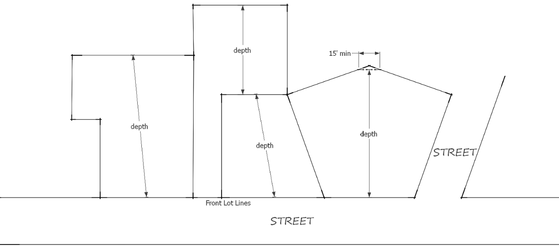
B. Lot Width: Width of a lot shall be measured perpendicular to and at the midpoint of the line used to determine lot depth.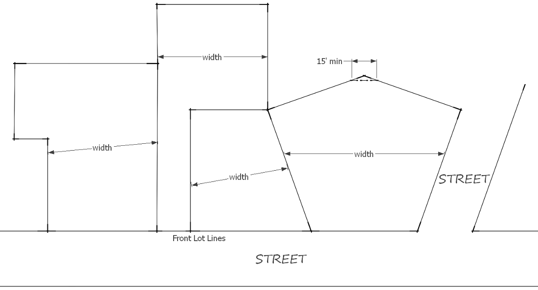
LOT, PARTIALLY DEVELOPED: (This definition for RMC 4-4-130, Tree Cutting and Land Clearing Regulations, only.) A lot or parcel of land upon which a structure is located and which is of sufficient area so as to be capable of accommodating increased development pursuant to the Renton Zoning Code; or which may be subdivided in accordance with the City subdivision regulations.
LOT TYPES: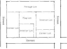
A. Lot, Corner: A lot abutting upon any combination of two (2) or more streets, including private streets (e.g., unit lot drives), access easements, or shared driveways, but excluding alleys, at their intersection, or upon two (2) parts of the same street, such streets or parts of the same street forming an interior angle of less than one hundred thirty-five degrees (135°) within the lot lines.
B. Lot, Flag: A lot with property lines that generally form the outline of a flag and flagpole with access to a public road typically provided through the relatively narrow portion of the lot (i.e., the “flagpole”).
C. Lot, Interior: A lot that generally abuts or has frontage on only one (1) street (or other means of access that may be permitted).
D. Lot, Through: A lot that has two (2) opposing ends each fronting on a street.
E. Lot, Small Cluster: See CLUSTER DEVELOPMENT.
LOT, UNDEVELOPED: A platted lot or parcel of land upon which no structure exists.
LOT, UNIT: A lot created from the subdivision of a parent site, through the unit lot subdivision process, exclusively for the construction and use of an attached townhouse dwelling and any accessory facilities or private yards.
LOW IMPACT DEVELOPMENT (LID): A stormwater and land use management strategy that strives to mimic pre-disturbance hydrologic processes of infiltration, filtration, storage, evaporation and transpiration by emphasizing conservation, use of on-site natural features, site planning, and distributed stormwater management practices that are integrated into a project design (pursuant to the Surface Water Design Manual).
LOW IMPACT LAND USE: Land uses which are not likely to have a significant adverse impact on critical areas because of the low intensity of the use, minimal levels of human activity, limited use of machinery or chemicals, site design or arrangement of buildings and structures, incorporation of mitigation measures, or other factors.
LOWEST FLOOR: The lowest floor of the lowest enclosed area (including basement). An unfinished or flood-resistant enclosure, usable solely for parking of vehicles, building access or storage, in an area other than a basement area, is not considered a building’s lowest floor; provided, that such enclosure is not built so as to render the structure in violation of the applicable non-elevation design requirements of RMC 4-3-050G4d.
(Ord. 3891, 2-25-1985; Ord. 4056, 4-30-1987; Ord. 4071, 6-1-1987; Ord. 4351, 5-4-1992; Ord. 4522, 6-5-1995; Ord. 4740, 7-19-1999; Ord. 4351, 5-4-1992; Ord. 4517, 5-8-1995; Ord. 4522, 6-5-1995; Ord. 4660, 3-17-1997; Ord. 4715, 4-6-1998; Ord. 4716, 4-13-1998; Ord. 4751, 11-16-1998; Ord. 4835, 3-27-2000; Ord. 4851, 8-7-2000; Ord. 4854, 8-14-2000; Amd. Ord. 4963, 5-13-2002; Ord. 5100, 11-1-2004; Ord. 5137, 4-25-2005; Ord. 5153, 9-26-2005; Ord. 5469, 7-13-2009; Ord. 5472, 7-13-2009; Ord. 5520, 12-14-2009; Ord. 5633, 10-24-2011; Ord. 5676, 12-3-2012; Ord. 5702, 12-9-2013; Ord. 5728, 10-20-2014; Ord. 5749, 1-12-2015; Ord. 5818, 10-17-2016; Ord. 5828, 12-12-2016; Ord. 5867, 12-11-2017; Ord. 5976, 8-3-2020; Ord. 6076, 8-8-2022)