


Chapter 11.75
CRITICAL RESOURCE AREA OVERLAY (CR) ZONE
Sections:
Article I. Critical Areas General Provisions
11.75.014 Location of critical resource area overlay zone.
11.75.026 Construction with other laws.
11.75.028 Exemptions and exceptions.
Article II. Frequently Flooded Areas
11.75.040 Purpose and objectives.
Article III. Fish and Wildlife Habitat Conservation Areas
11.75.050 Purpose and objectives.
11.75.054 Determination process.
11.75.056 Habitat conservation areas.
11.75.060 Habitat conservation area boundary survey.
11.75.062 Fish/wildlife habitat management and mitigation plan.
Article IV. Wetlands
11.75.070 Purpose and objectives.
11.75.072 Identification and rating.
11.75.074 Regulated activities.
11.75.076 Exemptions and allowed uses in wetlands.
11.75.080 Wetland mitigation ratios.
11.75.082 Critical area report for wetlands.
11.75.084 Compensatory mitigation.
Article V. Geologically Hazardous Areas
11.75.094 Classification and designation.
11.75.096 Determination process.
11.75.098 Geotechnical report.
Article VI. Critical Aquifer Recharge Areas (CARAs)
11.75.104 Critical recharge area designation.
11.75.107 Management recommendations and standards.
Appendices
Appendix A: Washington State Wetlands Identification and Delineation Manual (1997), or as amended.
Appendix D: Wetlands in Washington State Vol. 1, 2, or as amended.
Appendix E: Wetland Mitigation in Washington State, Parts 1 and 2 (2006), or as amended.
Appendix F: Information to be included in a wetland report.
Appendix H: Washington Priority Habitats and Species (1999), or as amended.
Appendix I: Shoreline Master Program for Adams County, or as amended.
Appendix J: Critical Areas Ordinance for Adams County, or as amended.
Appendix K: Washington State Wetlands Identification and Delineation Manual for Eastern Washington.
Appendix L: Columbia Basin Ground Water Management Area Plan.
Appendix M: Critical Areas Ordinance Maps, or as amended.
Article I. Critical Areas General Provisions
11.75.010 Purpose.
The purpose of this chapter is to promote the general health, safety and welfare of city residents by conserving and protecting critical areas. The critical resource area overlay (CR) zone protects and preserves critical environmental resources while allowing appropriate development activities when carried out in a responsible manner with minimal impacts on the environmental resources. In addition, this chapter serves to protect the public health, welfare and safety; to clean water, and to habitat conservation areas. This chapter is enacted to protect critical areas by regulating development within or adjacent to such areas/lands, while providing property owners with reasonable economic use of their land. (Ord. 2143 § 1 (Att. A), 2020).
11.75.012 Authority.
The Washington State Growth Management Act under Chapter 36.70A RCW requires local government to adopt development regulations to conserve natural resource lands and to preclude land uses or development incompatible with critical areas.
Compliance with the provisions of this chapter does not constitute compliance with other federal, state, and local regulations and permit requirements that may be required (for example, shoreline substantial development permits, HPA permits, Army Corps of Engineers Section 404 permits, NPDES permits). The applicant is responsible for complying with these requirements, apart from the process established in this chapter. Where applicable, the designated official will encourage use of information such as permit applications to other agencies or special studies prepared in response to other regulatory requirements to support required documentation submitted for critical areas review. (Ord. 2143 § 1 (Att. A), 2020).
11.75.014 Location of critical resource area overlay zone.
The city’s critical resource areas maps provide generalized information on the location of critical areas, including wetlands, habitat conservation areas, frequently flooded areas, geologically hazardous areas and aquifer recharge/wellhead protection areas. A site-specific analysis, which indicates that any critical area regulated by this chapter or Chapter 11.80 RCC exists on a lot, will result in that portion of the lot being classified as a critical area or floodplain area. (Ord. 2143 § 1 (Att. A), 2020).
11.75.016 Definitions.1
“Active recreation” means activities that refresh or restore one’s strength, spirits or vitality through physical movement or action.
“Administrator” means the mayor of the city of Ritzville or designee appointed to administer provisions of this chapter and may delegate authority to other employees to assist in its administration. The administrator, under direction of the city of Ritzville, shall adopt and revise, as required, such forms and instructions as are necessary or appropriate to serve the public and carry out provisions of this chapter. The administrator shall review and process critical area and site plan review procedures as provided in the Ritzville Municipal Code.
“Applicant” means a person who files an application for permit under this chapter and who is either the owner of the land on which that proposed activity would be located, a lessee of the land, the person who would actually control and direct the proposed activity or the authorized agent of such a person.
1. Allowed Activity. An “allowed activity” is a use that due to other regulations or previous reviews is unlikely to result in a critical areas impact. These activities are subject to review by the city, but do not require a separate critical area review or report. Since these activities are not “exempt,” the critical areas standards continue to apply, and the underlying permit could be conditioned to ensure that the activity complies with critical areas protection.
“Aquifer recharge” means the process of infiltration and migration of which ground water is replenished.
“Aquifers” refers to ground water-bearing geologic formations that contain enough saturated permeable material to yield significant quantities of water to wells.
“Best available science” means using the most current, widely accepted scientific data, research, studies and/or reports in making land use and policy decisions when designating and protecting environmentally sensitive areas. See WAC 365-195-900.
“Best management practices” means conservation practices or systems of practices and management measures that:
1. Control soil loss and reduce water quality degradation caused by nutrients, animal waste, toxins, and sediment; and
2. Minimize adverse impacts to surface water and ground water flow, circulation patterns, and to the chemical, physical and biological characteristics of the natural environment.
“Buffer” means an area adjacent to and surrounding a site or location, which serves as a protection from adverse impacts by maintaining the area in a naturally vegetated condition.
“Buffer management” means actions and practices conducted for the purpose of protection and enhancement of critical areas by moderating or eliminating adverse impacts from adjacent land(s) or areas to create a buffer from encroachment by urban growth areas.
“Critical aquifer recharge areas” are areas with a critical recharging effect on aquifers used for potable water, including areas where an aquifer that is a source of drinking water is vulnerable to contamination that would affect the potability of the water; or is susceptible to reduced recharge.
“Critical areas” include the following areas and ecosystems:
1. Frequently flooded areas;
2. Areas with a critical recharging effect on aquifers used for potable water, referred to in this chapter as critical aquifer recharge areas;
3. Geologically hazardous areas;
4. Fish and wildlife habitat conservation areas; and
5. Wetlands.
“EIS” means an environmental impact statement; a detailed document which analyzes the significant impacts of a particular project or proposal, possible alternatives, mitigation measures and unavoidable environmental impacts.
“Erosion hazard areas” are those areas containing soils which, according to the United States Department of Agriculture Natural Resources Conservation Service Soil Survey Program, may experience significant erosion. Erosion hazard areas also include coastal erosion-prone areas and channel migration zones.
“Exotic species” means any introduced species of plant or animal occurring in Washington, not found historically in the state.
Federal or State Endangered, Threatened, Candidate Species.
1. “Endangered species” means a native species that is seriously threatened with extinction throughout all or a significant portion of its range.
2. “Threatened species” means a native species that is likely to become endangered within the foreseeable future throughout all or a significant portion of its range without cooperative management or removal of threats.
3. “Candidate species” means a native species under review for possible listing as endangered, threatened, or sensitive. A species will be considered for candidate designation if sufficient scientific evidence suggests that its status may meet criteria defined for “endangered,” “threatened” or “sensitive.” Currently listed state threatened or state sensitive species may also be designated as state candidate species if their status is in question.
“Fish and wildlife habitat conservation areas” (also referred to as habitat conservation areas) are areas that serve a critical role in sustaining needed habitats and species for the functional integrity of the ecosystem, and which, if altered, may reduce the likelihood that the species will persist over the long term. These areas may include, but are not limited to:
1. Areas with which endangered, threatened and sensitive species have primary association;
2. Important habitat areas that may also include species of local importance:
a. “Important habitat areas” include seasonal ranges and/or habitat elements with which species of local importance have primary association and which, if altered, may reduce the likelihood that the species will maintain and reproduce over the long term. Included would be areas of high relative population density or species diversity, breeding habitat, winter range and movement corridors. They would also include habitats that are of limited availability or high vulnerability to alteration such as cliffs, talus, wetlands, and riparian zones;
b. “Species of local importance” are defined based upon their population status, sensitivity to habitat manipulation, or high recreational value and public appeal;
3. Naturally occurring ponds under 20 acres and their submerged aquatic beds that provide fish and wildlife habitat;
4. Waters of the state;
5. Lakes, ponds, streams and rivers planted with game fish by a governmental or tribal entity;
6. State natural area preserves and natural resource conservation areas.
“Frequently flooded areas” include lands in the floodplain subject to a one percent or greater chance of flooding in any given year. These areas include, but are not limited to, streams, rivers, lakes, coastal areas, wetlands and other natural water sources.
“Functions and values” means the beneficial roles served by wetlands, including but not limited to water quality protection and enhancement; fish and wildlife habitat; food chain support; flood storage, conveyance and attenuation; ground water recharge; erosion control; historical, archaeological and aesthetic value protection and recreation. (These beneficial roles are not listed by priority or in order.)
“Geologically hazardous area” means an area not suited to commercial, residential or industrial development because of its susceptibility to erosion, sliding, earthquakes or other geological events hazardous to public health and safety.
“Ground water management program” means a comprehensive program designed to protect ground water quality, to assure ground water quantity, and to provide for efficient management of water resources while recognizing existing ground water rights and meeting future needs consistent with local and state objectives, policies and authorities within a designated ground water management area or subarea developed pursuant to Chapter 173-100 WAC.
“Habitat conservation area” includes (1) areas with which species designated as endangered, threatened, and sensitive under Section 7 of the Endangered Species Act have primary association; (2) habitats and species of local importance; (3) naturally occurring ponds under 20 acres and their submerged aquatic beds that provide wildlife habitat; (4) waters of the state; and (5) state natural area preserves and natural resource conservation areas.
“Impacts” means adverse effects of one thing upon another.
“Long-term commercial significance” means the capacity, productivity and soil composition of land for long-term commercial production, in consideration with the land’s proximity to population areas, and the possibility of more intense uses of the land.
“Minor modification” means a minor deviation in the property development standards or minor addition to or alteration of an existing building or structure affecting or equaling no more than 10 percent of the area of that structure or building.
“Mitigation” means actions which avoid, minimize, rectify, reduce, eliminate, compensate or correct otherwise probable significant adverse environmental impacts (WAC 197-11-768).
“Native species” means plant or animal species naturally occurring in Washington, excluding introduced species not found historically in the state.
“Potable water” means water, because of its quality, that is fit to drink and for human consumption.
“Primary association” means key habitat components that are critical to the life cycle of native wildlife species, i.e., nesting sites, wintering areas, and migration corridors. Loss of these values will result in fragmentation into subpopulations or extinction of populations from local areas.
“Principal use” means the primary or predominant use to which the property is or may be devoted, and to which all other uses on the premises are accessory.
“Priority habitats and species program” means Washington Department of Wildlife’s system of classifying habitats and associated species that are of specific concern due to population status and/or sensitivity to habitat manipulation.
“Restoration” means actions performed to reestablish wetland functional characteristics and processes which have been lost by alterations, activities or catastrophic events within an area which no longer meets the definition of a wetland.
“Riparian” means of, on, or pertaining to the bank of a natural course of water.
“Sensitive species” means a native species that is vulnerable or declining and is likely to become endangered or threatened in a significant portion of its range without cooperative management or removal of threats.
“Sole source aquifer” means an aquifer designated by EPA as the sole or principal source of drinking water for a given aquifer service area; this is an aquifer which is needed to supply 50 percent or more of the drinking water for that area and for which there are no reasonably available alternative sources should the aquifer become contaminated.
“Species of local importance” are those species that are of local concern due to their population status or their sensitivity to habitat alteration or that are game species.
“State-listed monitor species” means native species that:
1. Were at one time classified as endangered, threatened, or sensitive;
2. Require habitat that has limited availability during some portion of its life cycle;
3. Are indicators of environmental quality;
4. Require further field investigations to determine population status;
5. Have unresolved taxonomy which may bear upon their status classification;
6. May be competing with and having impacts on other species of concern; or
7. Have significant popular appeal.
“Vernal pools” are precipitation-based, seasonal wetlands. For the purposes of this code, vernal pools shall only include scab rock and rain pool vernal as described in the Eastern Washington Wetland Rating System. The following is from page 80 of the manual:
To be classified as a vernal pool the wetland should be less than 4000 sq. feet, and meet at least two of the following criteria:
1. Its only source of water is rainfall or snowmelt from a small contributing basin and has no groundwater input. The wetland will typically lie in areas where the basalt has been exposed by the ice age floods. It has formed in a small surface depression in the basalt and does not have an outlet.
2. Wetland plants are typically present only in the spring; the summer vegetation is typically upland annuals. The water is present in the wetland for only short periods of time, usually less than 120 days. Wetland plants will be found only during the time of standing water or immediately afterwards. NOTE: If you find perennial, “obligate,” wetland plants the wetland is probably NOT a vernal pool.
3. The soils in the wetland are shallow (< 30 cm or 1 ft deep) and are underlain by an impermeable layer such as basalt or clay. You can determine the depth of the soil by digging a small hole with a tile spade. Determining if the impermeable layer is basalt should be easy (can’t dig any further) but identifying a clay layer is harder. You may have to take some of the soil between your fingers, add water, and feel if it is “greasy” and smooth (without grit). If in doubt, use the “ribbon test” for clay.
4. Surface water is present for less than 120 days during the “wet” season. Estimating the duration of surface water in a vernal pool wetland is difficult unless one visits the wetland several times and notes the time at which the wetland fills and the time it dries out. Information about the drying and wetting cycles in the wetland may sometimes be obtained from local residents or frequent visitors to the wetland.
“Wellhead protection area” means the surface and subsurface area surrounding a water well or well field that supplies a public water system through which contaminants are reasonably likely to pass and eventually reach the water well or well field, as has been designated pursuant to Chapter 246-290 WAC.
“Wetland” or “wetlands” means areas that are inundated or saturated by surface water or ground water at a frequency and duration sufficient to support, and that under normal circumstances do support, a prevalence of vegetation typically adapted for life in saturated soil conditions. Wetlands generally include swamps, marshes, bogs and similar areas. Wetlands do not include those artificial wetlands intentionally created from nonwetland sites, including but not limited to irrigation and drainage ditches, grass-lined swales, canals, detention facilities, wastewater treatment facilities, farm ponds and landscape amenities, or those wetlands created after July 1, 1990, that were unintentionally created as a result of the construction of a road, street, or highway. Wetlands may include those artificial wetlands intentionally created from nonwetland areas created to mitigate conversion of wetlands. (Ord. 2143 § 1 (Att. A), 2020).
11.75.018 General provisions.
The city’s critical resource areas map provides generalized information on the location of critical areas. A site-specific analysis which indicates that any critical area regulated by this section or Chapter 11.80 RCC existing on a lot will result in that portion of the lot being classified as a critical area or floodplain area.
A. The following features shall not be altered or developed except as permitted by this section:
1. Water features, including rivers, streams, creeks, lakes, ponds and wetlands;
2. Areas that provide habitat to priority species; or
3. Geologically hazardous areas, including landslides and slopes 40 percent or greater.
B. The city requires applicants to demonstrate that development on a site determined to have critical areas will protect the resource by taking one of the following steps (listed in order of preference):
1. Avoid impacts to the resources altogether;
2. Minimizing the impacts by limiting the degree or magnitude of the action and its implementation by using appropriate technology, or by taking affirmative steps to avoid or reduce impacts;
3. Rectifying the impact by repairing, rehabilitating or restoring the affected environment to the conditions existing at the time of initiation of the project;
4. Reducing or eliminating the impact over time by preservation and maintenance operations during the life of the action;
5. Compensating for the impact by replacing, enhancing, or providing substitute resources or environments.
C. If a critical resource area on the property that is being developed in the city crosses a jurisdictional line, the city shall coordinate with Adams County in the review of the project.
D. Multiple Designations of Critical Areas.
1. Critical area designations overlay other land uses including designated natural resource lands. If two or more land use designations apply to a given parcel, or a portion of a parcel, both or all designations and their corresponding regulations shall be applicable.
2. The application of these provisions shall be considered in the application of other permits and development activities authorized by adopted city of Ritzville codes including without limitation the zoning code, subdivision code, etc.
E. Reference Maps and Inventories. The distribution of critical areas within the city of Ritzville is described and displayed on reference materials and on maps maintained by the administrator. These reference materials are intended for general information only and do not depict site-specific designations. These reference materials shall include but are not limited to the following:
1. Maps.
a. Any maps created through a critical area review process;
b. WDFW Priority Habitats and Species maps, as amended;
c. USGS Quadrangle maps;
d. Flood insurance rate maps (FEMA), as amended;
e. Flood boundary and floodway maps (FEMA), as amended;
f. Aerial photographs;
g. USFWS National Wetland Inventory maps, as amended;
h. Columbia Basin Ground Water Management Area maps;
i. Previously completed maps in the vicinity of a permit application.
2. Documents.
a. Flood Insurance Study for Adams County;
b. City of Ritzville Comprehensive Plan, as amended;
c. Natural Resources Conservation Service Soil Survey for Adams County;
d. Federal Wetlands Delineation Manual (1987), as amended;
e. Washington State Wetlands Identification and Delineation Manual (WDOE No. 96-94), as amended;
f. Washington State Wetlands Rating System for Eastern Washington (WDOE No. 02-06-19), as amended;
g. “Wetland Mitigation in Washington State, Part 1: Agency Policies and Guidance” (Version 1, Pub. No. 06-06-011a);
h. “Wetland Mitigation in Washington State, Part 2: Developing Mitigation Plans” (Version 1, Pub. No. 06-06-11b);
i. Management Recommendations for Washington’s Priority Habitats and Species (WDFW), as amended;
j. Management Recommendations for Washington’s Priority Habitats – Wetlands (WDFW), as amended;
k. Previously completed special reports conducted in the vicinity of a permit application;
l. Columbia Basin Ground Water Management Area Plan, as amended.
F. Applicability of Reference Maps. The reference maps identified herein display general locations and approximate boundaries of potential critical areas and are not intended to determine regulatory boundaries. Further field determination and analysis will be necessary for specific development proposals to establish exact location, extent, and nature of critical areas.
G. Best Available Science.
1. Critical area reports and decisions to alter critical areas shall rely on the best available science to protect the functions and values of critical areas and must give special consideration to conservation and protection measures necessary to preserve or enhance their functions and values.
2. The best available science is that scientific information applicable to the critical area. These data must be prepared by local, state, or federal natural resource agencies, a qualified scientific professional or team of qualified scientific professionals that is consistent with criteria established in WAC 365-195-900 through 365-195-925.
3. In the context of critical area protection, a valid scientific process is one that produces reliable information useful in understanding the consequences of a local government’s regulatory decisions, and in developing critical area policies and development regulations that will be effective in protecting the functions and values of critical areas. To determine whether information received during the permit review process is reliable scientific information, the administrator or his/her designee shall determine whether the source of the information displays the characteristics of a valid scientific process. Such characteristics are as follows:
4. Peer Review. The information has been critically reviewed by other persons who are qualified scientific experts in that scientific discipline. The proponents of the information have addressed the criticism of the peer reviewers. Publication in a referred scientific journal usually indicates that the information has been appropriately peer reviewed.
5. Methods. The methods used to obtain the information are clearly stated and reproducible. The methods are standardized in the pertinent scientific discipline or, if not, the methods have been appropriately peer reviewed to assure their reliability and validity.
6. Logical Conclusions and Reasonable Inferences. The conclusions presented are based on reasonable assumptions supported by other studies and consistent with the general theory underlying the assumptions. The conclusions are logically and reasonably derived from the assumptions and supported by the data presented. Any gaps in information and inconsistencies with other pertinent scientific information are adequately explained.
7. Quantitative Analysis. The data has been analyzed using appropriate statistical or quantitative methods.
8. Context. The information is placed in proper context. The assumptions, analytical techniques, data, and conclusions are appropriately framed with respect to the prevailing body of pertinent existing information.
9. References. The assumptions, analytical techniques, and conclusions are well referenced with citations to relevant, credible literature and other pertinent existing information. (Ord. 2143 § 1 (Att. A), 2020).
11.75.020 Uses.
Uses allowed on a lot containing, or within 200 feet of, a critical area shall be the same as those listed in the use zone in which the lot is located. Each use shall be evaluated using the review process required for the use in the zone in conjunction with the requirements of this section and applicable state and federal regulations. Nothing in this section is intended to preclude the reasonable use of property. (Ord. 2143 § 1 (Att. A), 2020).
11.75.022 Permitting.
All uses proposed within the critical resource overlay zone shall be subject to the site plan review process.
A. All applications for permits to conduct activities having possible impact(s) to critical areas must:
1. Establish if critical areas are present by providing a report prepared by a qualified professional with demonstrated qualifications in the area of concern;
2. The report shall use scientifically valid methods and studies in the analysis of critical area data and the field reconnaissance and referenced in the source of science used;
3. Identify if impact(s) could occur;
4. Make an estimate of the probable impact(s); and
5. Refer to the provisions herein to guide development decisions which strive to mitigate impact(s).
B. The report contents shall as a minimum contain the following:
1. The name and contact information of the applicant, a description of the proposal, and identification of the permit requested.
2. A copy of the site plan for the development proposal in accordance with Chapter 11.190 RCC shall be obtained prior to any clearing or development activities within 200 feet of the critical area.
3. The dates, names and qualifications of the persons preparing the report and documentation of any fieldwork performed on the site.
C. Permits may be granted for proposals which include mitigation measures for probable impact(s) if the mitigation measures adequately protect the people and critical area(s) involved. A fee to assist in recovery of administrative costs incurred during review of a new proposal to determine potentially significant impacts to critical areas will be collected at the time of application.
D. Unless mitigation measures are included, requests for permits shall be denied which would result in activities that would:
1. Significantly degrade a wetland or fish and wildlife habitat conservation area;
2. Put people or property in a position of unacceptable risk with respect to floods or geological hazards;
3. Tend to aggravate geological hazards; or
4. Harm critical recharging areas for aquifers. (Ord. 2143 § 1 (Att. A), 2020).
11.75.024 Amendment process.
The provisions of this chapter may be amended from time to time, but not more frequently than one time in a year, through a public review and hearing process that includes at least one public hearing by the city of Ritzville planning commission and at least one public hearing by the city council. (Ord. 2143 § 1 (Att. A), 2020).
11.75.026 Construction with other laws.
A. Abrogation and Greater Restrictions. This chapter does not repeal, abrogate, and is not to be construed so as to impair any existing regulations, easements, covenants, or deed restrictions. However, when this chapter imposes greater restrictions, the provisions of this chapter shall prevail.
B. Interpretation. Provisions of this chapter shall be liberally construed to serve the purposes of this chapter and shall be interpreted in a manner that supports the intent of any comprehensive plans and regulations implementing those plans, as adopted by the city of Ritzville council. (Ord. 2143 § 1 (Att. A), 2020).
11.75.028 Exemptions and exceptions.
Certain activities are exempt from requirements of this chapter. Other regulated activities may be granted specific exceptions or an administrative modification. This section lists activities which are exempt and exceptions which may be granted to requirements of this chapter. All activities which are exempted, excepted or granted modifications shall prevent, minimize and/or compensate for impacts to critical areas to the maximum extent possible. Such activities, which are exempted, accepted or granted modifications, shall not be exempt from other laws or permit requirements, which may be applicable.
A. The following are exemptions to provisions of this chapter; however, the listed exemptions may not be exempted from other state or federal regulations or permit requirements:
1. Activities in response to emergencies that threaten public health, property, safety or welfare, as verified by the administrator to be the minimum necessary to alleviate the emergency.
2. Legally constructed structures, in existence on the date the ordinance codified in this chapter becomes effective, that do not meet requirements of this chapter may be remodeled or reconstructed; provided, that the new construction or related activity does not further encroach into the critical area(s) and/or natural resource land(s). Remodeling or reconstruction shall be subject to all other requirements of the zoning code.
3. Normal and routine activities conducted by public agencies to control mosquitoes throughout the city of Ritzville.
4. Normal and routine maintenance of legally constructed irrigation and drainage ditches (when located within an already approved easement, right-of-way, etc.).
5. Normal and routine maintenance of agricultural ponds, livestock watering ponds and fish ponds; provided, that such activities do not involve conversion of any wetland or stream not used for such purpose on the effective date of the ordinance codified in this chapter.
6. Artificial structures intentionally constructed from upland areas for purposes of storm water drainage or water quality control, or ornamental landscape ponds, which are not part of a mitigation plan as described and detailed herein.
7. Normal and routine maintenance of public streets, state highways, public utilities and public park facilities. Maintenance and repair do not include any modification that changes the character, scope, or size of the original structure, facility, or improved area, nor does it include construction of a maintenance road or dumping of maintenance debris.
8. The following electric, natural gas, cable communications and telephone utility-related activities, when undertaken pursuant to best management practices to avoid impacts to critical areas (water quality, floodplain and other permits may be required if applicable):
a. Normal and routine maintenance or repair of existing utility structures or right-of-way when located within an already approved easement, right-of-way, etc.;
b. Relocation of electric facilities, lines, equipment or appurtenances, not including substations with an associated voltage of 55,000 volts or less, when required and/or approved by the administrator (when located within an already approved easement, right-of-way, etc.);
c. Relocation of natural gas, cable communications, telephone facilities, lines, pipes, mains, equipment or appurtenances when required and/or approved by the administrator;
d. Installation or construction in approved street rights-of-way and replacement, operation or alteration of all facilities listed in subsections (A)(8)(b) and (c) of this section.
9. Buffer management when approved by the administrator and all agencies with jurisdiction. Management may be limited to actions necessary to reduce risk to adjacent properties from falling trees, wildfire, etc., provided the management is the minimum necessary to protect both the critical area and property.
10. Existing and ongoing agricultural activities normal or necessary to general farming conducted according to industry-recognized best management practices, particularly as advocated by the Natural Resources Conservation Service, including the raising of crops or the grazing of livestock.
B. Reasonable Use Exception.
1. Nothing in this chapter is intended to preclude the reasonable economic use of property. For purposes of this section, reasonable economic use of a lot or parcel shall be deemed available if any one of the specific uses listed as permitted, accessory or conditional in this title, in the zone in which the subject property is located, can be accommodated on the subject lot.
2. If requirements of this chapter, as applied to a specific property, would deny all reasonable economic use of the lot, development consistent with the use regulations of this title can be permitted through a variance to the standards herein if the applicant demonstrates all of the following to the satisfaction of the planning commission when reviewed through the site plan review process:
a. There is no other reasonable economic use or feasible alternative to the proposed development with less impact on the critical area(s); and
b. The proposed development does not pose a threat to the public health, safety and welfare on or off of the subject lot; and
c. Any variation permitted from requirements of this section shall be the minimum necessary to allow for reasonable economic use of the property; and
d. The inability of the applicant to derive reasonable economic use of the property is not the result of actions by the applicant after the effective date of the ordinance codified in this chapter in subdividing the property or adjusting a boundary line which creates the undeveloped condition; and
e. The proposal mitigates the impacts on the critical area(s) to the maximum extent possible.
C. Reasonable Use Decision Process. An application for reasonable use exception shall be filed with the administrator and shall be considered by the board of adjustment at a public hearing. The application shall include the following information which will be considered during the evaluation for granting a reasonable use exception:
1. A description of the critical area(s) located on the property and the required standards of this code that are applicable to the proposed development;
2. An analysis of the minimum amount of development that would be considered reasonable economic use of the lot, including a narrative which describes the factual basis for this determination;
3. An analysis of the impact(s) associated with development in subsection (C)(2) of this section that would be imposed on the critical area(s);
4. An analysis of whether any other reasonable economic use with less impact on the critical area(s) and buffers is possible. This should include a discussion of whether there is any practical on-site alternative to the proposed development with less impact, including reduction in density, phasing of project implementation, change in timing of activities, revision of lot layout, and/or related site planning considerations that would allow reasonable economic use with less adverse impact to the critical area(s) or buffers. (Ord. 2143 § 1 (Att. A), 2020).
11.75.030 Enforcement.
Enforcement of provisions of this code shall generally be pursuant to the provisions of RCC 1.02.010. In addition to the procedures in Chapter 1.02 RCC, the following enforcement provisions shall apply:
A. It shall be unlawful for any person, firm, corporation or association, or agent thereof, to violate any provision of this code. Any person who violates any of the provisions of this chapter shall be guilty of a civil offense and may be fined a sum not to exceed $500.00 for each offense as per RCC 1.02.010. After a notice of violation has been given, each day of site work in conjunction with the notice of violation shall constitute a separate offense. The city of Ritzville will stop work on any existing permits and will halt the issuance of any or all future permits or approval for any activity which violates the provisions of this code until all penalties and restorations are made in full.
B. Upon a determination by the administrator of this code that a violation has occurred, he/she shall issue a notice in writing either by certified mail with return receipt requested or by personal service to the person incurring the same. The notice of violation and order shall be served upon each record owner, taxpayer and occupier and, when applicable, the contractor(s). The notice shall include the amount of the penalty imposed and shall describe the violation with reasonable particularity. In appropriate cases, corrective action shall be identified in the notice, which corrective action shall be taken within a specific and reasonable time.
C. A person receiving a written notice of violation may appeal said notice to the administrative official. The administrative official shall determine the status of the violation.
D. The city attorney may enforce compliance with this chapter by such injunctive, declaratory or other actions as deemed necessary to ensure that violations are prevented, ceased, or abated. (Ord. 2143 § 1 (Att. A), 2020).
Article II. Frequently Flooded Areas
11.75.040 Purpose and objectives.
It is the intent of the city of Ritzville to recognize and diminish potential hazards that may be caused by inappropriate development in areas where severe and costly flooding is anticipated to occur. Based on historical observation and information collected by the Federal Emergency Management Agency, the city endorses a cautious posture that limits construction in areas located within zones designated to be flood prone. This decision stems from local, as well as state and federal, understanding that development limitations in these areas help to serve the health, safety and public welfare of the people of the city of Ritzville.
Protection measures designed to minimize hazards in frequently flooded areas already exist for the city, as detailed in Chapter 12.08 RCC, Flood Damage Prevention, originally adopted through Ordinance 1002 § 1.1, 2000, and as hereafter amended. (Ord. 2143 § 1 (Att. A), 2020).
11.75.042 Classification.
Classification of frequently flooded areas, according to the minimum guidelines, should include, at a minimum, the 100-year floodplain designations of the Federal Emergency Management Agency and the National Flood Insurance Program. The following categories of frequently flooded areas established for the purpose of classification are:
A. Floodways. The channel of a stream, plus any adjacent floodplain areas, that must be kept free of encroachment in order that the base flood be carried without substantial increases in flood heights.
B. Floodplains. The floodway and special flood hazard areas.
C. Special Flood Hazard Areas. The area adjoining the floodway which is subject to a one percent or greater chance of flooding in any given year, as identified in the Adams County Flood Insurance Study (July 26, 1977), and determined by the Federal Insurance Administration. (Ord. 2143 § 1 (Att. A), 2020).
11.75.044 Designation.
All city of Ritzville lands and waters which are currently identified within the 100-year floodplain in the Federal Emergency Management Agency publication entitled “The Flood Insurance Rate Map for Adams County, WA, and Incorporated Areas,” dated January 16, 2009, with accompanying flood insurance rate and boundary maps are designated as frequently flooded areas. If and when this study becomes updated to reflect new conditions, designation of frequently flooded areas will include the changes.
All new development within designated frequently flooded areas shall be in compliance with the city of Ritzville flood damage prevention ordinance, as it is now or hereafter amended. (Ord. 2143 § 1 (Att. A), 2020).
Article III. Fish and Wildlife Habitat Conservation Areas
11.75.050 Purpose and objectives.
It is the intent of the city of Ritzville to recognize the importance of protecting habitat conservation areas while at the same time encouraging continued economic development of the city. Implementation of this article is directed toward preserving resources by steering incompatible development away from these areas and/or by providing adequate and appropriate mitigation measures to development that alleviate negative impacts. The city of Ritzville adopts by reference the Adams County Critical Areas Ordinance, Appendix J, Washington Priority Habitats and Species (1999), or as amended, Appendix G and the Washington Priority Habitats and Species (1999), or as amended, Appendix H.
Various federal, state and private agencies and individuals manage established fish and wildlife habitat conservation areas within the city of Ritzville. In recognition of their expertise and experience in local habitat management, the city of Ritzville supports their efforts to preserve and protect those critical fish and wildlife habitat conservation areas by acknowledging that cooperation and communication are essential to achieve common habitat conservation goals. The following objectives are the guiding factors in the application of this article to future development in the city of Ritzville:
A. Identify and map categories of fish and wildlife habitat conservation areas in the city of Ritzville, based in part on information supplied by Washington Department of Wildlife’s Priority Habitat and Species Program, and other sources.
B. Cooperate with federal, state and private agencies and individuals who have primary authority to manage specific fish and wildlife habitat conservation areas within certain parts of the city of Ritzville.
C. Encourage preservation of adequate size blocks of land necessary for species survival and corridor areas that allow for migratory travel.
D. The city of Ritzville recognizes that species of wildlife in this locality are in a state of continuing flux, and a prudent understanding of this phenomenon is vital in guiding decision-makers to balance conservation of wildlife species with promotion of wise, desirable growth.
E. Development decisions will serve to protect local wildlife values and reflect the needs and desires of the public.
F. The city of Ritzville recognizes the need for a degree of flexibility in weighing the significance of different areas of fish and wildlife habitat conservation. Specifically, the magnitude of protection for priority habitat areas is anticipated to be more pronounced than that which addresses important habitat areas. (Ord. 2143 § 1 (Att. A), 2020).
11.75.052 Identification.
According to WAC 365-190-080, “fish and wildlife habitat conservation” means land management for maintaining populations of species in suitable habitats within their natural geographic distribution so that the habitat available is sufficient to support viable populations over the long term and isolated subpopulations are not created. This does not mean maintaining all individuals of all species at all times, but it does mean not degrading or reducing populations or habitats so that they are no longer viable over the long term. Counties and cities should engage in cooperative planning and coordination to help assure long-term population viability.
A. “Areas of fish and wildlife habitat conservation” are defined as:
1. Areas where endangered, threatened, and sensitive species have a primary association;
2. Habitats and species of local importance, as determined locally;
3. Naturally occurring ponds under 20 acres and their submerged aquatic beds that provide fish or wildlife habitat;
4. Waters of the state;
5. Lakes, ponds, streams and rivers planted with game fish by a governmental or tribal entity (these include water bodies planted under auspices of a federal, state or local program, or which support important fish species as identified by Washington Department of Wildlife); or
6. State natural area preserves, natural resource conservation areas, and state wildlife areas.
B. The city of Ritzville allows for the nomination of species/habitats of local importance, which process shall be included in the amendment process identified in RCC 11.75.024. In order to nominate species/habitats of local importance as candidates for designation within the category of important habitat areas, an individual or organization must:
1. Demonstrate a need for special consideration;
2. Propose relevant management strategies considered effective and within the scope of this chapter;
3. Provide species habitat location(s) on a map (scale 1:24,000).
C. In order to accommodate the needs and desires of the people of the city of Ritzville, public input shall be required to include species and/or habitats in the important habitat area classification identified in RCC 11.75.056. Where the habitats and species classified as priority habitat area are responsive, concurrently, with official changes in federal and/or state threatened or endangered listings/delistings, to include or uninclude species and/or habitats in the important habitat area classification, these regulations must be amended through a formal process for nomination as described in this regulation.
D. There are no anadromous fisheries within the city of Ritzville. (Ord. 2143 § 1 (Att. A), 2020).
11.75.054 Determination process.
The city of Ritzville will review each development permit application to determine if the provisions of this article will be applied to the project. In making the determination, the city of Ritzville may use any of the reference maps and/or inventories identified in RCC 11.75.018. The following progressive steps will occur upon a determination by the city of Ritzville that a fish and/or wildlife habitat conservation area may exist on a site proposed for a development permit:
A. Step One. The city of Ritzville staff will determine if there are any possible fish and/or wildlife habitat conservation areas on site. This determination shall be made following a review of information available, as well as a site inspection and/or a consultation with a qualified fish and/or wildlife biologist, if deemed necessary by the city of Ritzville. If no fish and/or wildlife habitat conservation area is determined to be present, this article shall not apply to the review of the proposed development.
B. Step Two. If it is determined by the city of Ritzville staff that a fish and/or wildlife habitat conservation area may be present, a site inspection and consultation with federal and/or state wildlife agency personnel shall be conducted to more definitively determine if a fish and/or wildlife habitat conservation area exists on the site. If no, this article shall not apply to the review of the proposed development. If yes, the applicant shall submit a habitat boundary survey and a habitat management and mitigation plan, as provided for in this article. (Ord. 2143 § 1 (Att. A), 2020).
11.75.056 Habitat conservation areas.
If a development is proposed within 200 feet or within a distance which could impact habitat conservation areas, the applicant shall provide a habitat management plan (HMP), prepared by a qualified expert in the species in question, for evaluation by the city, state, and federal agencies. The HMP shall be based on sound habitat management practices and shall be designed to achieve specific habitat objectives. The city shall ask the appropriate resource agencies to review and comment on the development impacts and provisions of the HMP.
A. Classes of Wildlife Conservation Areas.
1. The following rating system is hereby adopted as the rating system for classifying fish and wildlife conservation areas for the city of Ritzville:
a. Class 1 Fish and Wildlife Conservation Area. Class 1 wildlife conservation areas are lands including the following:
i. All seasonal ranges and habitat elements with which federal- and state-listed endangered, threatened and sensitive species have primary association and which, if altered, may reduce the likelihood that the species will maintain and reproduce over the long term.
ii. Areas targeted for preservation by federal, state and/or local governments which provide fish and wildlife benefits, such as important waterfowl areas identified by the U.S. Fish and Wildlife Service and state conservation areas identified by Washington State.
b. Class 2 Fish and Wildlife Conservation Areas. Class 2 wildlife conservation areas are all-season ranges and habitat elements with which state-listed candidate and monitored species or priority game species have a primary association and which, if altered, may produce a likelihood that the species will maintain and reproduce over the long term.
c. Class 3 Fish and Wildlife Conservation Areas. Class 3 wildlife conservation areas are habitats which include attributes such as comparatively high wildlife density, high wildlife species richness, significant wildlife breeding habitat, seasonal ranges or movement corridors of limited availability and/or high vulnerability. These habitats may include caves, islands, meadows, mature forests, snag-rich areas, talus slopes and urban natural open space.
B. Habitat Performance Standards.
1. Alterations shall not degrade the functions and values of the habitat. A fish and wildlife habitat conservation area may be altered only if the proposed alterations of the habitat or the mitigation proposed does not degrade the functions and values of the habitat.
2. Nonindigenous species shall not be introduced. No nonindigenous plant, wildlife, or fish species shall be introduced into a habitat conservation area unless authorized by a federal or state permit or approval.
3. Mitigation shall attempt to preserve contiguous corridors. Where wildlife corridors exist such as along stream corridors mitigation shall preserve those corridors by appropriate buffer widths.
4. Approvals of activities may be conditioned. The planning commission may condition approval of activities allowed within or adjacent to a habitat conservation area or its buffers as necessary to minimize or mitigate adverse impacts.
5. Mitigation shall achieve equivalent or greater biological function. Mitigation alterations to habitat conservation areas shall achieve equivalent or greater biological function. Mitigation shall address each function affected by alteration to the habitat.
6. Buffers, Establishment of Buffers.
a. Buffers are required for activities in or adjacent to fish and wildlife habitat conservation areas when needed to protect habitat functions and values. Wildlife habitat buffer widths shall reflect the sensitivity of the habitat type and intensity of human activity proposed to be conducted nearby and shall be consistent with recommendations issued by the Washington Department of Fish and Wildlife.
b. The planning commission may allow the recommended habitat area buffer width to be reduced in accordance with a critical areas report, the best available science, and the management recommendations issued by the Washington Department of Fish and Wildlife, only if:
i. It will not reduce habitat functions and values.
ii. It will provide additional resource protection, such as buffer enhancement.
iii. The total area contained in a buffer area after averaging is no less than the area that would have been contained in the standard buffer.
iv. Maximum buffer width is not reduced by more than 50 percent in any location.
7. Signs and Fencing of Habitat Conservation Areas. The outer perimeter of the habitat conservation area or buffer shall be marked in the field by appropriate temporary markers during construction and, if necessary, shall be delineated by a permanent marker after completion of the activity at the discretion of the administrator. Fencing may be required at the discretion of the administrator to exclude harmful disturbances such as grazing animals. (Ord. 2143 § 1 (Att. A), 2020).
11.75.058 Designation.
A. If an area that is subject to a development permit application is determined to be a priority habitat area after going through the determination process described herein, it shall be designated as such, and a habitat boundary survey and a habitat management and mitigation plan shall be developed as provided for in this chapter.
B. If an area that is subject to a development permit application is determined to be an important habitat area after going through the determination process described herein, it shall be designated as such, and habitat boundary survey and a habitat management and mitigation plan may be required as provided for in this chapter. Designation as either a priority or important habitat area is not intended to deny development opportunities; rather, it is aimed at either steering growth to more suitable areas where fish and wildlife values will not be unduly compromised or developing appropriate and adequate mitigation measures to alleviate potential negative impacts. (Ord. 2143 § 1 (Att. A), 2020).
11.75.060 Habitat conservation area boundary survey.2
A. If it is determined through the process identified herein that a priority habitat area exists on a site that is the subject of a development permit application, a fish/wildlife habitat boundary survey and evaluation shall be conducted by a fish or wildlife biologist, as appropriate, who is knowledgeable of wildlife habitat within the city of Ritzville. The wildlife habitat boundary shall be field staked by the biologist and surveyed by a land surveyor for disclosure on all final plats, maps, etc.
B. If it is determined through the process identified herein that an important habitat area exists on a site that is the subject of a development permit application, a fish/wildlife habitat boundary survey and evaluation may be required as described within this chapter, and if the proposal is determined to have a probable adverse impact on the habitat area. When required, all provisions of the habitat boundary survey and evaluation described in this section shall be followed.
C. The director may waive the requirement for the survey if:
1. The proposed development is not within the extended proximity of the associated habitat;
2. There is adequate information available on the area proposed for development to determine the impacts of the proposed development and appropriate mitigating measures; and
3. The applicant provides voluntary deed restrictions that are approved by the city of Ritzville.
D. The fish/wildlife habitat boundary and any associated buffer shall be identified on all plats, maps, plans and specifications submitted for the project. (Ord. 2143 § 1 (Att. A), 2020).
11.75.062 Fish/wildlife habitat management and mitigation plan.3
A fish/wildlife habitat management and mitigation plan is required for all proposed developments determined to be within a priority habitat area. For those proposed developments determined to be within important habitat area, a fish/wildlife habitat management and mitigation plan may be required if it is determined by the city of Ritzville that the proposal will have probable adverse impacts on the habitat area.
A. When required, a fish/wildlife habitat management and mitigation plan shall be prepared by a biologist who is knowledgeable of wildlife habitat within the city of Ritzville.
B. The fish/wildlife habitat management and mitigation plan shall demonstrate, when implemented, that the net loss of ecological function of habitat is minimal.
C. Based on the best available science, the fish/wildlife habitat management and mitigation plan shall identify how impacts from the proposed project shall be mitigated, as well as the necessary monitoring and contingency actions for the continued maintenance of the habitat conservation area and any associated buffer.
D. The fish/wildlife habitat management and mitigation plan shall include maps and narrative descriptions that address at least the following items:
1. Avoiding the impact altogether by not taking a certain action or parts of an action;
2. Minimizing impacts by limiting the degree or magnitude of the action and its implementation by using appropriate technology, or by taking affirmative steps to avoid or reduce impacts;
3. Rectifying the impact by repairing, rehabilitating or restoring the affected environment;
4. Compensating for the impact by replacing, enhancing or providing substitute resources or environments.
E. A plan by the applicant that explains how any adverse impacts created by the proposed development will be mitigated, including without limitation the following techniques:
1. Use of any federal, state or local management recommendations which have been developed for the species or habitats in the area;
2. Establishment of appropriate and adequate buffer zones;
3. Preservation of critically important plants and trees;
4. Limitation of access to the habitat conservation area;
5. Seasonal restriction of construction activities;
6. Establishment of a timetable for periodic review of the plan.
F. A detailed discussion of ongoing management practices which will protect the habitat conservation area after the project site has been fully developed, including proposed monitoring, contingency, maintenance and surety programs.
G. The director may waive the requirement for the habitat management and mitigation plan if:
1. The proposed development is not within the extended proximity of the associated habitat;
2. There is adequate information available on the area proposed for development to determine the impacts of the proposed development and appropriate mitigating measures; and
3. The applicant provides voluntary deed restrictions that are approved by the city of Ritzville. (Ord. 2143 § 1 (Att. A), 2020).
Article IV. Wetlands
11.75.070 Purpose and objectives.
The purposes of this chapter are to:
A. Recognize and protect the beneficial functions performed by many wetlands, which include, but are not limited to, providing food, breeding, nesting and/or rearing habitat for fish and wildlife; recharging and discharging ground water; contributing to stream flow during low flow periods; stabilizing stream banks and shorelines; storing storm and floodwaters to reduce flooding and erosion; and improving water quality through biofiltration, adsorption, and retention and transformation of sediments, nutrients, and toxicants.
B. Regulate land use to avoid adverse effects on wetlands and maintain the functions and values of wetlands throughout city of Ritzville.
C. Establish review procedures for development proposals in and adjacent to wetlands.
1. Compliance with the provisions of this chapter does not constitute compliance with other federal, state, and local regulations and permit requirements that may be required (for example, shoreline substantial development permits, HPA permits, Army Corps of Engineers Section 404 permits, NPDES permits). The applicant is responsible for complying with these requirements, apart from the process established in this chapter. (Ord. 2143 § 1 (Att. A), 2020).
11.75.072 Identification and rating.
A. Identification and Delineation. Identification of wetlands and delineation of their boundaries pursuant to this chapter shall be done in accordance with the approved federal wetland delineation manual and applicable regional supplements. All areas within the city meeting the wetland designation criteria in that procedure are hereby designated critical areas and are subject to the provisions of this chapter. Wetland delineations are valid for five years; after such date the city shall determine whether a revision or additional assessment is necessary.
B. Rating. Wetlands shall be rated according to the Washington Department of Ecology wetland rating system, as set forth in the Washington State Wetland Rating System for Eastern Washington: 2014 Update (Ecology Publication No. 14-06-030, or as revised and approved by Ecology), which contains the definitions and methods for determining whether the criteria below are met.
1. Category I wetlands are: (a) alkali wetlands; (b) wetlands of high conservation value that are identified by scientists of the Washington Natural Heritage Program/DNR; (c) bogs and calcareous fens; (d) mature and old-growth forested wetlands over one-quarter acre with slow-growing trees; (e) forests with stands of aspen; and (f) wetlands that perform many functions very well (scores between 22 and 27). These wetlands are those that (a) represent a unique or rare wetland type; or (b) are more sensitive to disturbance than most wetlands; or (c) are relatively undisturbed and contain ecological attributes that are impossible to replace within a human lifetime; or (d) provide a high level of function.
2. Category II wetlands are: (a) forested wetlands in the floodplains of rivers; (b) mature and old-growth forested wetlands over one-quarter acre with fast-growing trees; (c) vernal pools; and (d) wetlands that perform functions well (scores between 19 and 21 points). These wetlands are difficult, though not impossible, to replace and provide high levels of some functions. These wetlands occur more commonly than Category I wetlands but still need a relatively high level of protection.
3. Category III wetlands have a moderate level of functions (scores between 16 and 18 points). These wetlands can be often adequately replaced with a well-planned mitigation project. Wetlands scoring between 16 and 18 points generally have been disturbed in some ways and are often less diverse or more isolated from other natural resources in the landscape than Category II wetlands.
4. Category IV wetlands have the lowest level of functions (scores fewer than 16 points) and are often heavily disturbed. These are wetlands that we should be able to replace, and in some cases be able to improve. However, experience has shown that replacement cannot be guaranteed in any specific case. These wetlands may provide some important functions and also need to be protected.
C. Illegal Modifications. Wetland rating categories shall not change due to illegal modifications made by the applicant or with the applicant’s knowledge. (Ord. 2143 § 1 (Att. A), 2020).
11.75.074 Regulated activities.
A. For any regulated activity, a critical area report, pursuant to RCC 11.75.082, may be required to support the requested activity.
B. The following activities are regulated if they occur in a regulated wetland or its buffer:
1. The removal, excavation, grading, or dredging of soil, sand, gravel, minerals, organic matter, or material of any kind.
2. The dumping of, discharging of, or filling with any material.
3. The draining, flooding, or disturbing of the water level or water table.
4. Pile driving.
5. The placing of obstructions.
6. The construction, reconstruction, demolition, or expansion of any structure.
7. The destruction or alteration of wetland vegetation through clearing, harvesting, shading, intentional burning, or planting of vegetation that would alter the character of a regulated wetland.
8. “Class IV – General Forest Practices” under the authority of the “1992 Washington State Forest Practices Act Rules and Regulations,” WAC 222-12-030, or as thereafter amended.
9. Activities that result in:
a. A significant change of water temperature.
b. A significant change of physical or chemical characteristics of the sources of water to the wetland.
c. A significant change in the quantity, timing or duration of the water entering the wetland.
d. The introduction of pollutants.
C. Subdivisions. The subdivision and/or short subdivision of land in wetlands and associated buffers are subject to the following:
1. Land that is located wholly within a wetland or its buffer may not be subdivided.
2. Land that is located partially within a wetland or its buffer may be subdivided; provided, that an accessible and contiguous portion of each new lot is:
a. Located outside of the wetland and its buffer; and
b. Meets the minimum lot size requirements of this title. (Ord. 2143 § 1 (Att. A), 2020).
11.75.076 Exemptions and allowed uses in wetlands.
A. Small isolated wetlands in arid landscapes often have a higher value and perform greater functions than in other settings. However, in certain circumstances, applying the buffers in Table 1.1 may result in buffer areas greater than that of the wetland being protected. In these instances, the city may consult with the Department of Ecology to determine whether exemptions from mitigation sequencing and/or reduced buffers are warranted.
B. Activities Allowed in Wetlands. The activities listed below are allowed in wetlands. These activities do not require submission of a critical area report, except where such activities result in a loss of the functions and values of a wetland or wetland buffer. These activities include:
1. Existing and ongoing agricultural activities; provided, that they implement applicable best management practices (BMPs) contained in the latest edition of the USDA Natural Resources Conservation Service (NRCS) Field Office Technical Guide (FOTG) or develop a farm conservation plan in coordination with the local conservation district. BMPs and/or farm plans should address potential impacts to wetlands from livestock, nutrient and farm chemicals, soil erosion and sediment control and agricultural drainage infrastructure. BMPs and/or farm plans should ensure that ongoing agricultural activities minimize their effects on water quality, riparian ecology, salmonid populations, and wildlife habitat.
2. Those activities and uses conducted pursuant to the Washington State Forest Practices Act and its rules and regulations, WAC 222-12-030, where state law specifically exempts local authority, except those developments requiring local approval for Class 4 – General Forest Practice permits (conversions) as defined in Chapter 76.09 RCW and Chapter 222-12 WAC.
3. Conservation or preservation of soil, water, vegetation, fish, shellfish, and/or other wildlife that does not entail changing the structure or functions of the existing wetland.
4. The harvesting of wild crops in a manner that is not injurious to natural reproduction of such crops and provided the harvesting does not require tilling of soil, planting of crops, chemical applications, or alteration of the wetland by changing existing topography, water conditions, or water sources.
5. Drilling for utilities/utility corridors under a wetland, with entrance/exit portals located completely outside of the wetland buffer; provided, that the drilling does not interrupt the ground water connection to the wetland or percolation of surface water down through the soil column. Specific studies by a hydrologist are necessary to determine whether the ground water connection to the wetland or percolation of surface water down through the soil column will be disturbed.
6. Enhancement of a wetland through the removal of nonnative invasive plant species. Removal of invasive plant species shall be restricted to hand removal unless permits from the appropriate regulatory agencies have been obtained for approved biological or chemical treatments. All removed plant material shall be taken away from the site and appropriately disposed of. Plants that appear on the Washington State Noxious Weed Control Board list of noxious weeds must be handled and disposed of according to a noxious weed control plan appropriate to that species. Revegetation with appropriate native species at natural densities is allowed in conjunction with removal of invasive plant species.
7. Educational and scientific research activities.
8. Normal and routine maintenance and repair of any existing public or private facilities within an existing right-of-way; provided, that the maintenance or repair does not expand the footprint of the facility or right-of-way.
9. Storm water management facilities. A wetland or its buffer can be physically or hydrologically altered to meet the requirements of an LID, runoff treatment or flow control BMP if all of the following criteria are met:
a. The wetland is classified as a Category IV or a Category III wetland with a habitat score of three to four points; and
b. There will be “no net loss” of functions and values of the wetland; and
c. The wetland does not contain a breeding population of any native amphibian species; and
d. The hydrologic functions of the wetland can be improved as outlined in questions 3, 4, and 5 of Chart 4 and questions 2, 3, and 4 of Chart 5 in the “Guide for Selecting Mitigation Sites Using a Watershed Approach,” (available here: http://www.ecy.wa.gov/biblio/0906032.html); or the wetland is part of a priority restoration plan that achieves restoration goals identified in a shoreline master program or other local or regional watershed plan; and
e. The wetland lies in the natural routing of the runoff, and the discharge follows the natural routing; and
f. All regulations regarding storm water and wetland management are followed, including but not limited to local and state wetland and storm water codes, manuals, and permits; and
g. Modifications that alter the structure of a wetland or its soils will require permits. Existing functions and values that are lost would have to be compensated/replaced.
Storm water LID BMPs required as part of new and redevelopment projects can be considered within wetlands and their buffers. However, these areas may contain features that render LID BMPs infeasible. A site-specific characterization is required to determine if an LID BMP is feasible at the project site. (Ord. 2143 § 1 (Att. A), 2020).
11.75.078 Wetland buffers.
A. Buffer Requirements. The following buffer widths have been established in accordance with the best available science. They are based on the category of wetland and the habitat score as determined by a qualified wetland professional using the Washington State Wetland Rating System for Eastern Washington: 2014 Update (Ecology Publication No. 14-06-030, or as revised and approved by Ecology). The adjacent land use intensity is assumed to be high.
1. The buffer widths in Table 1.1 assume that the buffer is vegetated with a native plant community appropriate for the ecoregion. If the existing buffer is unvegetated, sparsely vegetated, or vegetated with invasive species that do not perform needed functions, the buffer should either be planted to create the appropriate plant community, or the buffer should be widened to ensure that adequate functions of the buffer are provided.
|
Wetland Category |
Buffer width (in feet) based on habitat score |
||
|---|---|---|---|
|
3 – 5 |
6 – 7 |
8 – 9 |
|
|
Category I: Based on total score |
100 |
150 |
200 |
|
Category I: Bogs and wetlands of high conservation value |
250 |
||
|
Category II: Based on total score |
100 |
150 |
200 |
|
Category II: Vernal pool |
200 |
||
|
Category III (all) |
80 |
150 |
200 |
|
Category IV (all) |
50 |
||
B. Increased Wetland Buffer Area Width. Buffer widths shall be increased on a case-by-case basis as determined by the administrator when a larger buffer is necessary to protect wetland functions and values. This determination shall be supported by appropriate documentation showing that it is reasonably related to protection of the functions and values of the wetland. The documentation must include but not be limited to the following criteria:
1. The wetland is used by a state or federally listed plant or animal species or has essential or outstanding habitat for those species, or has unusual nesting or resting sites such as heron rookeries or raptor nesting trees; or
2. The adjacent land is susceptible to severe erosion, and erosion-control measures will not effectively prevent adverse wetland impacts; or
3. The adjacent land has minimal vegetative cover or slopes greater than 30 percent.
C. Buffer averaging to improve wetland protection may be permitted when all of the following conditions are met:
1. The wetland has significant differences in characteristics that affect its habitat functions, such as a wetland with a forested component adjacent to a degraded emergent component or a “dual-rated” wetland with a Category I area adjacent to a lower-rated area.
2. The buffer is increased adjacent to the higher-functioning area of habitat or more-sensitive portion of the wetland and decreased adjacent to the lower-functioning or less-sensitive portion as demonstrated by a critical areas report from a qualified wetland professional.
3. The total area of the buffer after averaging is equal to the area required without averaging.
4. The buffer at its narrowest point is never less than either three-quarters of the required width or 75 feet for Categories I and II, 50 feet for Category III and 25 feet for Category IV, whichever is greater.
D. Averaging to allow reasonable use of a parcel may be permitted when all of the following are met:
1. There are no feasible alternatives to the site design that could be accomplished without buffer averaging.
2. The averaged buffer will not result in degradation of the wetland’s functions and values as demonstrated by a critical areas report from a qualified wetland professional.
3. The total buffer area after averaging is equal to the area required without averaging.
4. The buffer at its narrowest point is never less than either three-quarters of the required width or 75 feet for Categories I and II, 50 feet for Category III and 25 feet for Category IV, whichever is greater.
a. Measurement of Wetland Buffers. All buffers shall be measured perpendicular from the wetland boundary as surveyed in the field. The buffer for a wetland created, restored, or enhanced as compensation for approved wetland alterations shall be the same as the buffer required for the category of the created, restored, or enhanced wetland. Buffers must be fully vegetated in order to be included in buffer area calculations. Lawns, walkways, driveways, and other mowed or paved areas will not be considered buffers or included in buffer area calculations.
E. Buffers on Mitigation Sites. All wetland mitigation sites shall have buffers consistent with the buffer requirements of this chapter. Buffers shall be based on the expected or target category of the proposed wetland mitigation site.
1. Overlapping Critical Area Buffers. If buffers for two contiguous critical areas overlap (such as buffers for a stream and a wetland), the wider buffer applies.
2. Allowed Buffer Uses. The following uses may be allowed within a wetland buffer in accordance with the review procedures of this chapter, provided they are not prohibited by any other applicable law and they are conducted in a manner so as to minimize impacts to the buffer and adjacent wetland:
a. Conservation and Restoration Activities. Conservation or restoration activities aimed at protecting the soil, water, vegetation, or wildlife.
b. Passive Recreation. Passive recreation facilities designed and in accordance with an approved critical area report, including:
i. Walkways and trails; provided, that those pathways are limited to minor crossings having no adverse impact on water quality. They should be generally parallel to the perimeter of the wetland, located only in the outer 25 percent of the wetland buffer area, and located to avoid removal of significant trees. They should be limited to pervious surfaces no more than five feet in width for pedestrian use only. Raised boardwalks utilizing non-treated pilings may be acceptable.
ii. Wildlife-viewing structures.
c. Educational and scientific research activities.
F. Normal and routine maintenance and repair of any existing public or private facilities within an existing right-of-way; provided, that the maintenance or repair does not increase the footprint or use of the facility or right-of-way.
1. The harvesting of wild crops in a manner that is not injurious to natural reproduction of such crops and provided the harvesting does not require tilling of soil, planting of crops, chemical applications, or alteration of the wetland by changing existing topography, water conditions, or water sources.
2. Drilling for utilities/utility corridors under a buffer, with entrance/exit portals located completely outside of the wetland buffer boundary; provided, that the drilling does not interrupt the ground water connection to the wetland or percolation of surface water down through the soil column. Specific studies by a hydrologist are necessary to determine whether the ground water connection to the wetland or percolation of surface water down through the soil column is disturbed.
3. Enhancement of a wetland buffer through the removal of nonnative invasive plant species. Removal of invasive plant species shall be restricted to hand removal. All removed plant material shall be taken away from the site and appropriately disposed of. Plants that appear on the Washington State Noxious Weed Control Board list of noxious weeds must be handled and disposed of according to a noxious weed control plan appropriate to that species. Revegetation with appropriate native species at natural densities is allowed in conjunction with removal of invasive plant species.
4. Repair and maintenance of nonconforming uses or structures, where legally established within the buffer, provided they do not increase the degree of nonconformity.
G. Signs and Fencing of Wetlands and Buffers (Optional).
1. Temporary Markers. The outer perimeter of the wetland buffer and the clearing limits identified by an approved permit or authorization shall be marked in the field with temporary “clearing limits” fencing in such a way as to ensure that no unauthorized intrusion will occur. The marking is subject to inspection by the administrator prior to the commencement of permitted activities. This temporary marking shall be maintained throughout construction and shall not be removed until permanent signs, if required, are in place.
2. Permanent Signs. As a condition of any permit or authorization issued pursuant to this chapter, the administrator may require the applicant to install permanent signs along the boundary of a wetland or buffer.
a. Permanent signs shall be made of an enamel-coated metal face and attached to a metal post or another nontreated material of equal durability. Signs must be posted at an interval of one every 50 feet, or one per lot if the lot is less than 50 feet wide, and must be maintained by the property owner in perpetuity. The signs shall be worded as follows or with alternative language approved by the administrator:
Protected Wetland Area Do Not Disturb
Contact City of Ritzville
Regarding Uses, Restrictions, and Opportunities for Stewardship
b. The provisions of subsection (G)(2)(a) of this section may be modified as necessary to assure protection of sensitive features or wildlife.
3. Fencing.
a. The applicant shall be required to install a permanent fence around the wetland or buffer when domestic grazing animals are present or may be introduced on site.
b. Fencing installed as part of a proposed activity or as required in this subsection shall be designed so as to not interfere with species migration, including fish runs, and shall be constructed in a manner that minimizes impacts to the wetland and associated habitat. (Ord. 2143 § 1 (Att. A), 2020).
11.75.080 Wetland mitigation ratios.
|
Category and Type of Wetland |
Creation or Reestablishment |
Rehabilitation |
Enhancement |
|---|---|---|---|
|
Category I: Bog Natural Heritage Site |
Not considered possible |
Case by case |
Case by case |
|
Category I: Mature Forest |
6:1 |
12:1 |
24:1 |
|
Category I: Based on Functions |
4:1 |
8:1 |
16:1 |
|
Category II: |
3:1 |
6:1 |
12:1 |
|
Category III: |
2:1 |
4:1 |
8:1 |
|
Category IV: |
1.5:1 |
3:1 |
6:1 |
(Ord. 2143 § 1 (Att. A), 2020).
11.75.082 Critical area report for wetlands.
The city of Ritzville will review each development permit application to determine if the provisions of this article will be applied to the project. In making the determination, the city of Ritzville may use any of the reference maps and/or inventories identified in RCC 11.75.018. If the administrator determines that the site of a proposed development includes, is likely to include, or is adjacent to a wetland, a wetland report, prepared by a qualified professional, shall be required. The expense of preparing the wetland report shall be borne by the applicant.
A. Minimum Standards for Wetland Reports. The written report and the accompanying plan sheets shall contain the following information, at a minimum:
1. The written report shall include at a minimum:
a. The name and contact information of the applicant; the name, qualifications, and contact information for the primary author(s) of the wetland critical area report; a description of the proposal; identification of all the local, state, and/or federal wetland-related permit(s) required for the project; and a vicinity map for the project.
b. A statement specifying the accuracy of the report and all assumptions made and relied upon.
c. Documentation of any fieldwork performed on the site, including field data sheets for delineations, rating system forms, baseline hydrologic data, etc.
d. A description of the methodologies used to conduct the wetland delineations, wetland ratings, or impact analyses including references.
e. Identification and characterization of all critical areas, wetlands, water bodies, shorelines, floodplains, and buffers on or adjacent to the proposed project area. For areas off site of the project site, estimate conditions within the project boundaries using the best available information.
f. For each wetland identified on site and within the project boundary, provide: the wetland rating, including a description of and score for each function, per RCC 11.75.072(B) and 11.75.078; required buffers; hydrogeomorphic classification; wetland acreage based on a professional survey from the field delineation (acreages for on-site portion and entire wetland area including off-site portions); Cowardin classification of vegetation communities; habitat elements; soil conditions based on site assessment and/or soil survey information; and to the extent possible, hydrologic information such as location and condition of inlets/outlets (if they can be legally accessed), estimated water depths within the wetland, and estimated hydroperiod patterns based on visual cues (e.g., algal mats, drift lines, flood debris, etc.). Provide acreage estimates, classifications, and ratings based on entire wetland complexes, not only the portion present on the proposed project site.
g. A description of the proposed actions including an estimation of acreages of impacts to wetlands and buffers based on the field delineation and survey and an analysis of site development alternatives including a no-development alternative.
h. An assessment of the probable cumulative impacts to the wetlands and buffers resulting from the proposed development.
i. A description of reasonable efforts made to apply mitigation sequencing pursuant to RCC 11.75.084 to avoid, minimize, and mitigate impacts to critical areas.
j. A discussion of measures, including avoidance, minimization, and compensation, proposed to preserve existing wetlands and restore any wetlands that were degraded prior to the current proposed land use activity.
k. A conservation strategy for habitat and native vegetation that addresses methods to protect and enhance on-site habitat and wetland functions.
l. An evaluation of the functions of the wetland and adjacent buffer. Include reference for the method used and data sheets.
2. A copy of the site plan sheet(s) for the project must be included with the written report and must include, at a minimum:
a. Maps (to scale) depicting delineated and surveyed wetland and required buffers on site, including buffers for off-site critical areas that extend onto the project site; the development proposal; other critical areas; grading and clearing limits; areas of proposed impacts to wetlands and/or buffers (include square footage estimates);
b. A depiction of the proposed storm water management facilities and outlets (to scale) for the development, including estimated areas of intrusion into the buffers of any critical areas. The written report shall contain a discussion of the potential impacts to the wetland(s) associated with anticipated hydroperiod alterations from the project. (Ord. 2143 § 1 (Att. A), 2020).
11.75.084 Compensatory mitigation.4
As determined necessary as provided for in this article, a wetland management and mitigation plan shall be required when impacts to a wetland are unavoidable during project development. Wetland management and mitigation plans shall be prepared by a biologist or wetland ecologist who is knowledgeable of wetland conditions within the city of Ritzville. Seek to minimize potential impacts to nonregulated wetland areas, including vernal pools excluded from this chapter in RCC 11.75.076.
A. Mitigation Sequencing. Before impacting any wetland or its buffer, an applicant shall demonstrate that the following actions have been taken. Actions are listed in the order of preference:
1. Avoid the impact altogether by not taking a certain action or parts of an action.
2. Minimize impacts by limiting the degree or magnitude of the action and its implementation by using appropriate technology, or by taking affirmative steps to avoid or reduce impacts.
3. Rectify the impact by repairing, rehabilitating, or restoring the affected environment.
4. Reduce or eliminate the impact over time by preservation and maintenance operations.
5. Compensate for the impact by replacing, enhancing, or providing substitute resources or environments.
6. Monitor the required compensation and take remedial or corrective measures when necessary.
B. Requirements for Compensatory Mitigation.
1. Compensatory mitigation for alterations to wetlands shall be used only for impacts that cannot be avoided or minimized and shall achieve equivalent or greater biologic functions. Compensatory mitigation plans shall be consistent with Wetland Mitigation in Washington State – Part 2: Developing Mitigation Plans – Version 1 (Ecology Publication No. 06-06-011b, Olympia, WA, March 2006 or as revised), and Selecting Wetland Mitigation Sites Using a Watershed Approach (Eastern Washington) (Publication No. 10-06-07, November 2010).
2. Mitigation ratios shall be consistent with RCC 11.75.080.
C. Compensating for Lost or Affected Functions. Compensatory mitigation shall address the functions affected by the proposed project, with an intention to achieve functional equivalency or improvement of functions. The goal shall be for the compensatory mitigation to provide similar wetland functions as those lost, except when either:
1. The lost wetland provides minimal functions, and the proposed compensatory mitigation action(s) will provide equal or greater functions or will provide functions shown to be limiting within a watershed through a formal Washington State watershed assessment plan or protocol; or
2. Out-of-kind replacement of wetland type or functions will best meet watershed goals formally identified by the city, such as replacement of historically diminished wetland types.
D. Types of Compensatory Mitigation. Mitigation for lost or diminished wetland and buffer functions shall rely on a type listed below in order of preference. A lower preference form of mitigation shall be used only if the applicant’s qualified wetland professional demonstrates to the approval authority’s satisfaction that all higher-ranked types of mitigation are not viable, consistent with the criteria in this section.
1. Restoration. The manipulation of the physical, chemical, or biological characteristics of a site with the goal of returning natural or historic functions to a former or degraded wetland. For the purpose of tracking net gains in wetland acres, restoration is divided into:
a. Reestablishment. The manipulation of the physical, chemical, or biological characteristics of a site with the goal of returning natural or historic functions to a former wetland. Reestablishment results in a gain in wetland acres (and functions). Activities could include removing fill material, plugging ditches, or breaking drain tiles.
b. Rehabilitation. The manipulation of the physical, chemical, or biological characteristics of a site with the goal of repairing natural or historic functions of a degraded wetland. Rehabilitation results in a gain in wetland function but does not result in a gain in wetland acres. Activities could involve breaching a dike to reconnect wetlands to a floodplain or return tidal influence to a wetland.
2. Establishment (Creation). The manipulation of the physical, chemical, or biological characteristics of a site to develop a wetland on an upland or deepwater site where a wetland did not previously exist. Establishment results in a gain in wetland acres. Activities typically involve excavation of upland soils to elevations that will produce a wetland hydroperiod, create hydric soils, and support the growth of hydrophytic plant species.
a. If a site is not available for wetland restoration to compensate for expected wetland and/or buffer impacts, the approval authority may authorize creation of a wetland and buffer upon demonstration by the applicant’s qualified wetland professional that:
i. The hydrology and soil conditions at the proposed mitigation site are conducive for sustaining the proposed wetland and that creation of a wetland at the site will not likely cause hydrologic problems elsewhere;
ii. Adjacent land uses and site conditions do not jeopardize the viability of the proposed wetland and buffer (e.g., due to the presence of invasive plants or noxious weeds, storm water runoff, noise, light, or other impacts); and
iii. The proposed wetland and buffer will eventually be self-sustaining with little or no long-term maintenance.
3. Enhancement. The manipulation of the physical, chemical, or biological characteristics of a wetland site to heighten, intensify, or improve specific function(s) or to change the growth stage or composition of the vegetation present. Enhancement is undertaken for specified purposes such as water quality improvement, floodwater retention, or wildlife habitat. Enhancement results in a change in some wetland functions and can lead to a decline in other wetland functions, but does not result in a gain in wetland acres. Activities typically consist of planting vegetation, controlling nonnative or invasive species, modifying site elevations or the proportion of open water to influence hydroperiods, or some combination of these activities. Applicants proposing to enhance wetlands or associated buffers shall demonstrate how the proposed enhancement will increase the wetland’s/buffer’s functions, how this increase in function will adequately compensate for the impacts, and how existing wetland functions at the mitigation site will be protected.
4. Protection/Maintenance (Preservation). Removing a threat to, or preventing the decline of, wetland conditions by an action in or near a wetland. This includes the purchase of land or easements, or repairing water control structures or fences. This term also includes activities commonly associated with the term “preservation.” Preservation does not result in a gain of wetland acres. Permanent protection of a Category I or II wetland and associated buffer at risk of degradation can be used only if:
a. The approval authority determines that the proposed preservation is the best mitigation option;
b. The proposed preservation site is under threat of undesirable ecological change due to permitted, planned, or likely actions that will not be adequately mitigated under existing regulations;
c. The area proposed for preservation is of high quality or critical for the health of the watershed or basin due to its location. Some of the following features may be indicative of high-quality sites:
i. Category I or II wetland rating (using the Wetland Rating System for Western Washington);
ii. Rare or irreplaceable wetland type (for example, bogs, mature forested wetlands, estuarine wetlands) or aquatic habitat that is rare or a limited resource in the area;
iii. The presence of habitat for priority or locally important wildlife species;
iv. Provides biological and/or hydrological connectivity;
v. Priority sites in an adopted watershed plan;
d. Permanent preservation of the wetland and buffer will be provided through a conservation easement or tract held by an appropriate natural land resource manager, such as a land trust;
e. The approval authority may approve other legal and administrative mechanisms in lieu of a conservation easement if it determines they are adequate to protect the site;
f. Ratios for preservation in combination with other forms of mitigation generally range from 10:1 to 20:1, as determined on a case-by-case basis, depending on the quality of the wetlands being impacted and the quality of the wetlands being preserved. Ratios for preservation as the sole means of mitigation generally start at 20:1.
E. Location of Compensatory Mitigation. Compensatory mitigation actions shall generally be conducted within the same subdrainage basin and on the site of the alteration except when the applicant can demonstrate that off-site mitigation is ecologically preferable. The following criteria will be evaluated when determining whether the proposal is ecologically preferable. When considering off-site mitigation, preference should be given to using alternative mitigation, such as a mitigation bank, an in-lieu-fee program, or advance mitigation.
1. There are no reasonable opportunities on site or within the subdrainage basin (e.g., on-site options would require elimination of high-functioning upland habitat), or opportunities on site or within the subdrainage basin do not have a high likelihood of success based on a determination of the capacity of the site to compensate for the impacts. Considerations should include: anticipated replacement ratios for wetland mitigation, buffer conditions and proposed widths, available water to maintain anticipated hydrogeomorphic classes of wetlands when restored, proposed flood storage capacity, and potential to mitigate riparian fish and wildlife impacts (such as connectivity).
2. On-site mitigation would require elimination of high-quality upland habitat.
3. Off-site mitigation has a greater likelihood of providing equal or improved wetland functions than the altered wetland.
4. Off-site locations shall be in the same subdrainage basin unless:
a. Established watershed goals for water quality, flood storage or conveyance, habitat, or other wetland functions have been established by the city and strongly justify location of mitigation at another site; or
b. Credits from a state-certified wetland mitigation bank are used as compensation, and the use of credits is consistent with the terms of the certified bank instrument.
F. Timing of Compensatory Mitigation. It is preferred that compensatory mitigation projects be completed prior to activities that will disturb wetlands. At the least, compensatory mitigation shall be completed immediately following disturbance and prior to use or occupancy of the action or development. Construction of mitigation projects shall be timed to reduce impacts to existing fisheries, wildlife, and flora.
1. The administrator may authorize a one-time temporary delay in completing construction or installation of the compensatory mitigation when the applicant provides a written explanation from a qualified wetland professional as to the rationale for the delay. An appropriate rationale would include identification of the environmental conditions that could produce a high probability of failure or significant construction difficulties (e.g., project delay lapses past a fisheries window, or installing plants should be delayed until the dormant season to ensure greater survival of installed materials). The delay shall not create or perpetuate hazardous conditions or environmental damage or degradation, and the delay shall not be injurious to the health, safety, or general welfare of the public. The request for the temporary delay must include a written justification that documents the environmental constraints that preclude implementation of the compensatory mitigation plan. The justification must be verified and approved by the city. (Ord. 2143 § 1 (Att. A), 2020).
Article V. Geologically Hazardous Areas
11.75.090 Purpose.
It is the intent of the city of Ritzville to reduce the threat posed to the health and safety of its citizens from commercial, residential or industrial development that may be sited in areas of significant geologic hazard. In some cases, it is recognized that risks from geologic hazards can be reduced or mitigated to acceptable levels through engineering design or modified construction practices. In other cases where technological efforts are not sufficient to reduce associated risks, building is best avoided. (Ord. 2143 § 1 (Att. A), 2020).
11.75.092 Identification.
According to WAC 365-190-030, “geologically hazardous areas” are areas that because of their susceptibility to erosion, sliding, earthquake or other geological event are not suited to siting commercial, residential and/or industrial development consistent with public health or safety concerns.
Hazards of concern that exist in the city of Ritzville include any land containing soils, geology or slopes that meet any of the following criteria:
A. Areas with slopes in excess of 45 percent;
B. Areas with these three characteristics:
1. Soil types with the properties of the Ringold formation (clay); and
2. Areas with the potential for water loading; and
3. Slopes in excess of 15 percent;
C. Slopes having gradients steeper than 80 percent subject to rock fall during seismic shaking;
D. Areas highly susceptible to liquefaction from seismic activity;
E. Soils within the city of Ritzville are subject to wind erosion. All developments subject to the provisions of this code that involve any land clearing activities shall have a dust control and wind erosion mitigation plan reviewed and approved by the city of Ritzville. (Ord. 2143 § 1 (Att. A), 2020).
11.75.094 Classification and designation.
A. All geologically hazardous areas shall be classified and designated by the city of Ritzville according to the level of risk associated with the hazardous area as established through an approved geologic hazard risk assessment and/or a geotechnical report submitted by the applicant in accordance with this chapter. The city of Ritzville may use on-site inspections and the information sources identified in this chapter as guidance in identifying the presence of potential geologically hazardous areas.
B. Geologically hazardous areas in the city of Ritzville shall be classified according to the following system:
1. Level 1: critical hazard areas shall be those areas with a known risk.
2. Level 2: awareness hazard areas shall be those areas that have a suspected risk. (Ord. 2143 § 1 (Att. A), 2020).
11.75.096 Determination process.
The city of Ritzville will review each development permit application to determine if the provisions of this article will be applied to the project. In making the determination, the city of Ritzville may use any of the reference maps and/or inventories identified in RCC 11.75.018.
A. Step One. City of Ritzville staff will determine if there are any possible geologically hazardous areas on site as defined herein. This determination will be made following a review of information available and a site inspection if appropriate. If no hazard area is determined to be present, this article shall not apply to the review of the proposed development.
B. Step Two. If it is determined that a geologically hazardous area may be present, the applicant shall submit a geologic hazard area risk assessment prepared by a licensed engineer or a licensed geologist. The risk assessment will include a description of the geology of the site and the proposed development; an assessment of the potential impact the project may have on the geologic hazard; an assessment of what potential impact the geologic hazard may have on the project; appropriate mitigation measures, if any; and a conclusion as to whether further analysis is necessary. The assessment will be signed by and bear the seal of the engineer or geologist that prepared it. No further analysis shall be required if the geologic hazard area risk assessment concludes that there is no geologic hazard present on the site, nor will the project affect or be affected by any potential geologic hazards that may be nearby. The city of Ritzville may waive the requirement for the geologic hazard area risk assessment where the only hazard present is wind erosion and where the dust control and wind erosion mitigation plan required in RCC 11.75.092 has been reviewed and approved by the city of Ritzville.
C. Step Three. If the professional preparing the risk assessment in step two concludes that further analysis is necessary, the applicant shall submit a geotechnical report as provided for herein.
D. A proposed development cannot be approved if it is determined by the geotechnical report that either the proposed development or adjacent properties will be at risk of damage from the geologic hazard, or that the project will increase the risk of occurrence of the hazard, and there are no adequate mitigation measures to alleviate the risks. (Ord. 2143 § 1 (Att. A), 2020).
11.75.098 Geotechnical report.
A. All geotechnical reports shall be prepared by a civil engineer licensed to practice in the state of Washington.
B. A geotechnical report shall include a description of the geology of the site, conclusions and recommendations regarding the effect of geologic conditions on the proposed development, and opinions and recommendations on the suitability of the site to be developed. The report shall evaluate the actual presence of geologic conditions giving rise to the geologic hazard, and an evaluation of the safety of the proposed project, and identification of construction practices, monitoring programs and other mitigation measures necessary. A bibliography of scientific citations shall be included as necessary.
C. The geotechnical report shall include a certification from the engineer preparing the report, including the engineer’s professional stamp and signature, stating all of the following:
1. The risk of damage from the project, both on and off site, is minimal;
2. The project will not materially increase the risk of occurrence of the hazard;
3. The specific measures incorporated into the design and operational plan of the project to eliminate or reduce the risk of damage due to the hazard;
4. Mitigation of adverse site conditions including slope stabilization measures and seismically unstable soils, if appropriate.
D. All mitigation measures, construction techniques, recommendations and technical specifications provided in the geotechnical report shall be applied during the implementation of the proposal. The engineer of record shall submit sealed verification at the conclusion of construction that development occurred in conformance with the approved plans. (Ord. 2143 § 1 (Att. A), 2020).
Article VI. Critical Aquifer Recharge Areas (CARAs)
11.75.102 Purpose.
It is the intent of the city of Ritzville to promote public health and safety by acknowledging the importance of preserving critical aquifer recharge areas that may exist in the city of Ritzville; and to comply with the Washington State Growth Management Act. These areas serve the vital function of replenishing ground water resources which, in Eastern Washington, account for a major share of the water for irrigation, municipal, industrial and domestic uses. Potable water is an essential life-sustaining element. Much of Washington’s water comes from ground water supplies. Preventing contamination is necessary to avoid exorbitant costs, hardships and potential physical harm to people. Further, the city of Ritzville adopts by reference the Columbia Basin Ground Water Management Area Plan, Appendix L. (Ord. 2143 § 1 (Att. A), 2020).
11.75.104 Critical recharge area designation.
Critical aquifer recharge areas (CARAs) are those areas with a critical recharging effect on aquifers used for potable water as defined by WAC 365-190-030(2). CARAs have prevailing geologic conditions associated with infiltration rates that create a high potential for contamination of ground water resources or contribute significantly to the replenishment of ground water. These areas include the following:
A. Wellhead Protection Areas. Wellhead protection areas may be defined by the boundaries of the 10-year time of ground water travel or boundaries established using alternate criteria approved by the Washington State Department of Health in those settings where ground water time of travel is not a reasonable delineation criterion, in accordance with WAC 246-290-135.
B. Sole Source Aquifers. Sole source aquifers are areas that have been designated by the U.S. Environmental Protection Agency pursuant to the Federal Safe Drinking Water Act.
C. Susceptible Ground Water Management Areas. Susceptible ground water management areas are areas that have been designated as moderately or highly vulnerable or susceptible in an adopted ground water management program developed pursuant to Chapter 173-100 WAC.
D. Special Protection Areas. Special protection areas are those areas defined by WAC 173-200-090.
E. Moderately or Highly Vulnerable Aquifer Recharge Areas. Aquifer recharge areas that are moderately or highly vulnerable to degradation or depletion because of hydrogeologic characteristics are those areas delineated by a hydrogeologic study prepared in accordance with the State Department of Ecology guidelines.
F. Moderately or Highly Susceptible Aquifer Recharge Areas. Aquifer recharge areas moderately or highly susceptible to degradation or depletion because of hydrogeologic characteristics are those areas meeting the criteria established by the State Department of Ecology. (Ord. 2143 § 1 (Att. A), 2020).
11.75.106 Applicability.
The approximate location and extent of critical aquifer recharge areas and municipal wellhead protection areas are shown on the wellhead protection area map. The map is to be used as a guide for the city, project applicants and/or property owners and may be continuously updated as new critical areas are identified. They are a reference and do not provide a final critical area designation. (Ord. 2143 § 1 (Att. A), 2020).
11.75.107 Management recommendations and standards.5
A. Activities may only be permitted in a critical aquifer recharge area if the administrator determines that the proposed activity will not cause contaminants to enter the critical aquifer and that the proposed activity will not adversely affect the recharging of the critical aquifer.
B. Any development which occurs within the city’s jurisdiction will use best management practices (BMPs) to prevent chemical and biological contaminants from entering underground waters and aquifers which are now, or in the future, likely to be used as a potable drinking water source. All persons, corporations, or other legal entities that engage in the construction of regulated facilities contained in this chapter must first obtain approval by the city through the critical area permit process and building permit(s).
C. Development activities within a wellhead protection area that have a high potential for contamination shall be required to do a hydrological study and shall develop and implement protection measures to prevent contamination.
D. Any changes in land use or type of new facilities where substances of moderate risk are used, stored, treated or handled, or which produce moderate risk waste, shall be designed to prevent the release of any such materials into the ground water.
E. Surface impoundments, defined by Chapter 173-303 WAC, shall be designed by a professional engineer and constructed with an impermeable liner and other components as appropriate to prevent discharge of any material on the ground surface and/or into the ground water system. Surface impoundments shall be designed and constructed in accordance with applicable governing law and have a minimum excess capacity equal to 120 percent of the projected volume of liquid to be contained including intentional and unintentional storm water capture. “Surface impoundment” means a facility or part of a facility which is a natural topographic depression, manmade excavation, or diked area formed primarily of earthen materials (although it may be lined with manmade materials), and which is designed to hold an accumulation of liquid dangerous wastes or dangerous wastes containing free liquids. The term includes holding, storage, settling, and aeration pits, ponds, or lagoons, but does not include injection wells.
F. In areas designated as high susceptibility for aquifer contamination, all uses shall be connected to the city’s sewer system. No new uses on a septic system are permitted in high susceptibility areas of critical aquifer recharge.
G. For uses locating within the critical aquifer recharge area, a disclosure form indicating activities and hazardous materials that will be used shall be provided for review and approval.
H. Impervious surfaces shall be minimized within the critical aquifer recharge areas.
I. Best management practices shall be followed by commercial and industrial uses located in the critical aquifer recharge areas.
J. Parks, Schools and Recreation Facilities. Fertilizer and pesticide management practices of schools, parks, other recreation facilities and similar uses shall use best management practices as prescribed by the Washington State University Cooperative Extension Services. (Ord. 2143 § 1 (Att. A), 2020).
11.75.108 Regulations.6
Activities may only be permitted in a critical aquifer recharge area if the applicant can show that the proposed activity will not cause contaminants to enter the aquifer, wellhead protection areas and that the proposed activity will not adversely affect the recharging of the aquifer.
A. Developments authorized within an aquifer recharge area shall comply with the following standards:
1. Connection to a public sanitary sewer system or an approved community sewer system shall be required. If connection to sanitary sewer is not feasible, on-site septic systems proposed on legal lots of record are permitted, provided:
a. The public health officer has designated the aquifer recharge area as an area of special concern in accordance with WAC 246-272B-21501;
b. The type of on-site system is approved by Adams County health department upon finding that the design of the system will not be detrimental to the community water supply;
c. The property owner shall enter a no protest agreement with a sanitary sewer provider as appropriate to the property location, agreeing to not protest the formation of a local improvement district for the extension of sanitary sewer. This agreement shall be recorded with the Adams County auditor.
2. The connection to an approved public water service shall be required.
3. All existing wells located on the subject property shall either be properly abandoned in accordance with the requirements of Adams County health department and the Department of Ecology or designated for irrigation purposes only. If an existing well is designated for irrigation purposes, then the following shall apply:
a. Evidence of a water right issued by the state of Washington for the use of the well shall be presented to the review authority. An application for a water right is not acceptable evidence of an actual right to appropriate water.
b. Certification from the public health officer stating that the well is properly constructed and sealed to prevent any contaminants from entering the wellhead shall be submitted to the review authority.
4. Storm water detention and retention facilities shall be designed using best available science and management practices to separate chemical and biological pollutants from the water prior to infiltration.
5. An analysis shall be conducted to assess the impact to ground water quality from the potential of nitrate loading to the ground water.
6. Areas highly susceptible of transporting contaminants to the ground water (i.e., natural drainages, springs, wetlands, etc.), as determined by the review authority, shall be designated as open space. All impervious surfaces shall maintain a 15-foot setback from areas identified as being highly susceptible and no amount of storm water runoff shall be directed towards the susceptible area(s).
B. All developments shall have an informational note placed on the face of plat stating, “this subdivision is located within an aquifer recharge area.” Best management practices shall be used for the containment of storm water and the application of pesticides and fertilizers.
C. A spill prevention and emergency response plan shall be prepared and submitted for review and approval. (Ord. 2143 § 1 (Att. A), 2020).
11.75.110 Hydrologic report.
Critical areas reports for critical aquifer recharge areas must meet the requirements of this section. Critical areas reports for two or more types of critical areas must meet the report requirements for each relevant type of critical area.
A. Preparation by Qualified Professional. An aquifer recharge area critical areas report shall be prepared by a qualified professional who is a hydrogeologist, geologist, or engineer, who is licensed in the state of Washington and has experience in preparing hydrogeologic assessments.
B. Incorporating of Best Available Science. The critical areas report shall use scientifically valid methods and studies in the analysis of critical areas data and field reconnaissance and reference the source of science used. The critical areas report shall evaluate the proposal and all probable impacts to critical areas in accordance with the provisions of this title.
C. Minimum Report Contents. At a minimum, the report shall contain the following:
1. The name and contact information of the applicant, a description of the proposal, and identification of the permit requested;
2. A copy of the site plan for the development proposal, including:
a. A map to scale depicting critical areas, buffers, the development proposal, and any areas to be cleared; and
b. A description of the proposed storm water management plan for the development and consideration of impacts to drainage alterations;
3. The dates, names, and qualifications of the persons preparing the report and documentation of any fieldwork performed on the site;
4. Identification and characterization of all critical areas, wellheads, aquifer recharge areas, wetlands, water bodies, and buffers adjacent to the proposed project area;
5. A statement specifying the accuracy of the report, and all assumptions made and relied upon;
6. An assessment of the probable cumulative impacts to critical areas resulting from development of the site and the proposed development;
7. An analysis of site development alternatives including a no-development alternative;
8. Any additional information required for the critical area as specified in the corresponding chapter.
D. Unless otherwise provided, a critical areas report may be supplemented by or composed, in whole or in part, of any reports or studies required by other laws and regulations or previously prepared for and applicable to the development proposal site, as approved by the city administrator. (Ord. 2143 § 1 (Att. A), 2020).
Appendices
Appendix A: Washington State Wetlands Identification and Delineation Manual (1997), or as amended.
Copies of this document are available at the city of Ritzville City Hall.
Appendix B: Regional Supplement to the Corps of Engineers Wetland Delineation Manual 2008, or as amended: Arid West Region.
Copies of this document are available at the city of Ritzville City Hall.
Appendix C: Washington State Wetlands Rating System for Eastern Washington: 2014 Updated (Ecology Publication No. 14-06-030).
Copies of this document are available at the city of Ritzville City Hall.
Appendix D: Wetlands in Washington State Vol. 1, 2, or as amended.
Copies of this document are available at the city of Ritzville City Hall.
Appendix E: Wetland Mitigation in Washington State, Parts 1 and 2 (2006), or as amended.
Copies of this document are available at the city of Ritzville City Hall.
Appendix F: Information to be included in a wetland report.
Information to Be Included in a Wetland Report.
A. A wetland report shall include the following:
1. Contact information, owner name and/or applicant, address, telephone, other;
2. Vicinity map;
3. When available, a copy of a National Wetland Inventory Map (U.S. Fish and Wildlife Service and/or a Stevens County Wetland Inventory Map) identifying the wetlands on or adjacent to the site;
4. A site map setting forth all of the following:
a. Surveyed wetland boundaries based upon a delineation;
b. Site boundary property lines and roads;
c. Internal property lines, rights-of-way, easements, etc.;
d. Existing physical features of the site including buildings, fences, and other structures, roads, parking lots, utilities, water bodies, etc.;
e. Contours at the smallest readily available intervals, preferably at two-foot intervals;
f. Hydrologic mapping showing patterns of surface water movement and known subsurface water movement into, though, and out of the site area;
g. Location of all test holes and vegetation sample sites, numbered to correspond with flagging in the field and field data sheets. The Department may require an air photo with overlays displaying the site boundaries and wetland delineation;
5. A report which includes the following:
a. Location information (legal description, parcel number and address);
b. Delineation report. The wetland boundaries on the site established by the delineation shall be staked and flagged in the field. If the wetland extends outside the site, the delineation report shall discuss all wetland areas within 150 feet of the site, but need only delineate those wetland boundaries within the site;
c. General site conditions including topography, acreage, and surface areas of all wetlands identified in the Stevens County Wetland Atlas and water bodies within one-quarter mile of the subject wetland(s);
d. Hydrological analysis, including topography, of existing surface and known significant subsurface flows into and out of the subject wetland(s);
e. Analysis of functional values of existing wetlands, including vegetative, faunal, and hydrologic conditions;
6. A summary of proposed activity and potential impacts to the wetland(s);
7. Recommended wetland category, including rationale for the recommendation;
8. Recommended buffer boundaries, including rationale for boundary locations;
9. Proposed on-site residential density transfer from wetlands and/or buffers to upland areas;
10. Site plan of proposed activity, including location of all parcels, tracts, easements, roads, structures, and other modifications to the existing site. The location of all wetlands and buffers shall be identified on the site plan.
Appendix G: Management Recommendations for Washington’s Priority Habitats and Species, or as amended.
Copies of this document are available at the city of Ritzville City Hall.
Can also be found online at the Washington Department of Fish and Wildlife:
https://wdfw.wa.gov/species-habitats/at-risk/phs/recommendations
Appendix H: Washington Priority Habitats and Species (1999), or as amended.
Copies of this document are available at the city of Ritzville City Hall.
Appendix I: Shoreline Master Program for Adams County, or as amended.
Copies of these documents are available at the city of Ritzville City Hall.
ADAMS COUNTY
SHORELINE MANAGEMENT MASTER PROGRAM
ORDINANCE NO. O-01-2015
July 20, 2015
Appendix J: Critical Areas Ordinance for Adams County, or as amended.
Copies of these documents are available at the city of Ritzville City Hall.
ADAMS COUNTY
CRITICAL AREAS AND RESOURCE LANDS
ORDINANCE NO. O-01-2019
January 14, 2019
Appendix K: Washington State Wetlands Identification and Delineation Manual for Eastern Washington.
Copies of this document are available at the city of Ritzville City Hall.
Appendix L: Columbia Basin Ground Water Management Area Plan.
Copies of these documents are available at the city of Ritzville City Hall.
Appendix M: Critical Areas Ordinance Maps, or as amended.
A. The city’s critical resource areas maps provide generalized information on the location of critical areas, including wetlands, habitat conservation areas, frequently flooded areas, geologically hazardous areas and aquifer recharge/wellhead protection areas. A site-specific analysis, which indicates that any critical area regulated by this chapter or Chapter 11.80 RCC exists on a lot, will result in that portion of the lot being classified as a critical area or floodplain area.
B. Applicability of Reference Maps. The reference maps identified herein display general locations and approximate boundaries of potential critical areas and are not intended to determine regulatory boundaries. Further field determination and analysis will be necessary for specific development proposals to establish exact location, extent, and nature of critical areas. It is the responsibility of the applicant and/or scientific professional to evaluate critical areas-based criteria provided in this chapter or Chapter 11.80 RCC.
1. Hydrologic Conditions.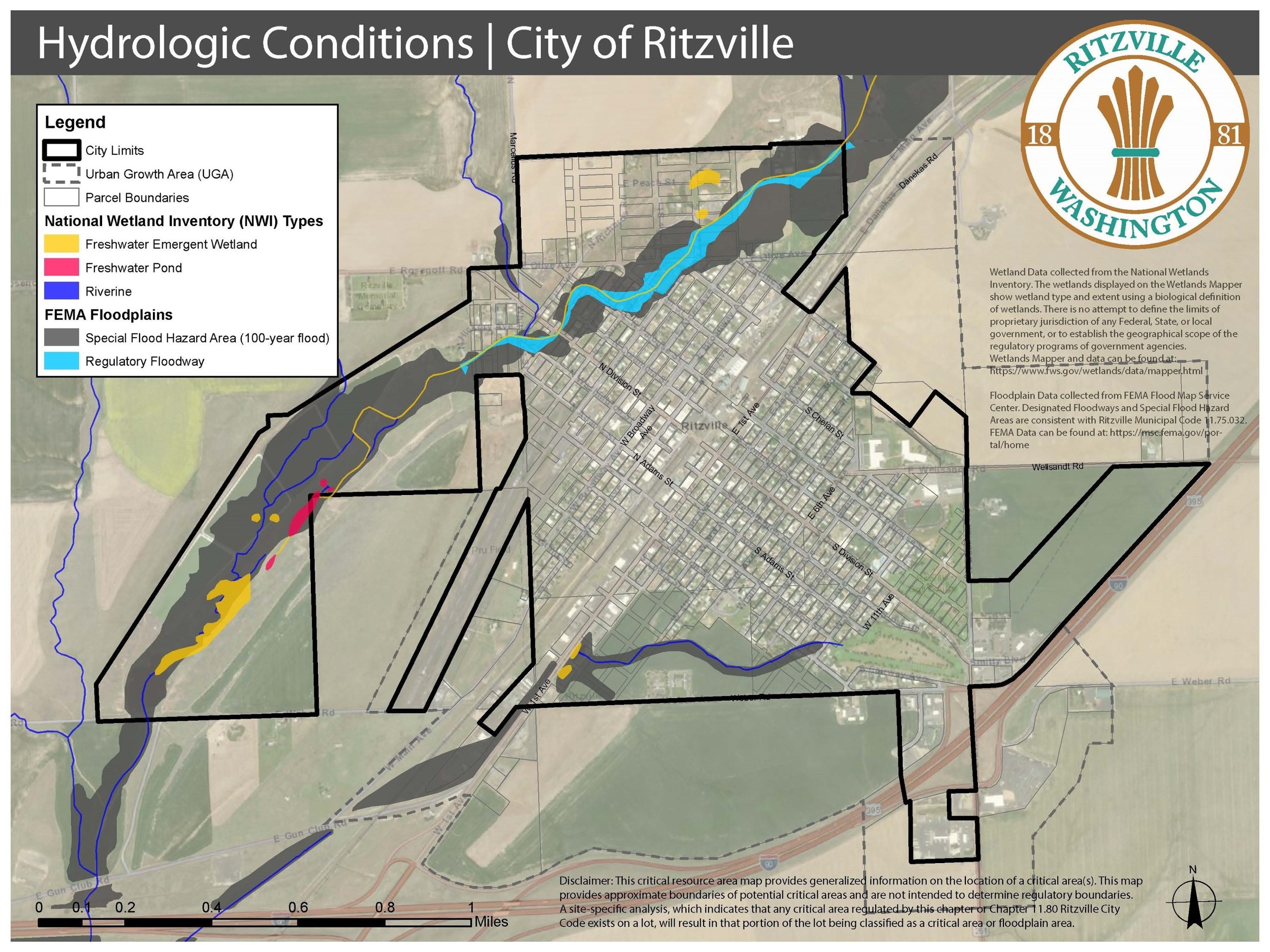
2. Depth to Water Table.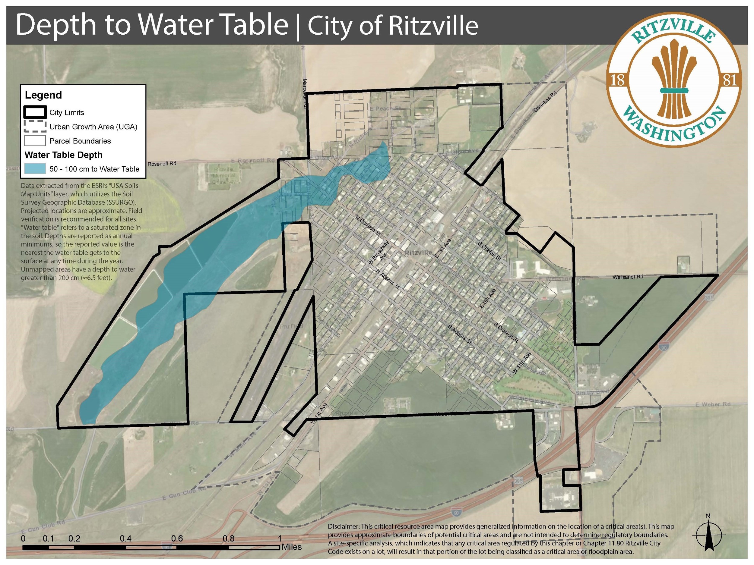
3. Slope of Terrain.
4. Well Depth Map.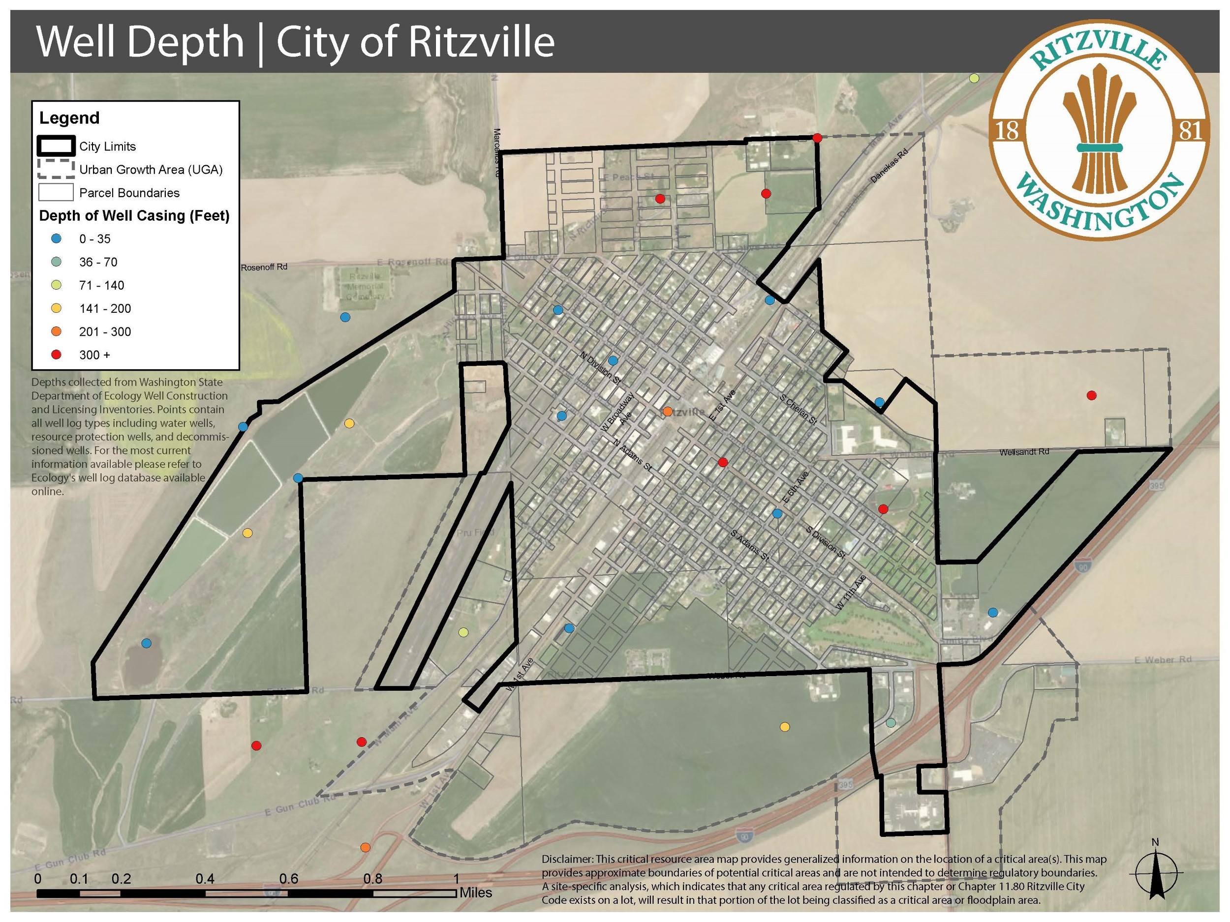
5. Wellhead Protection Area Map.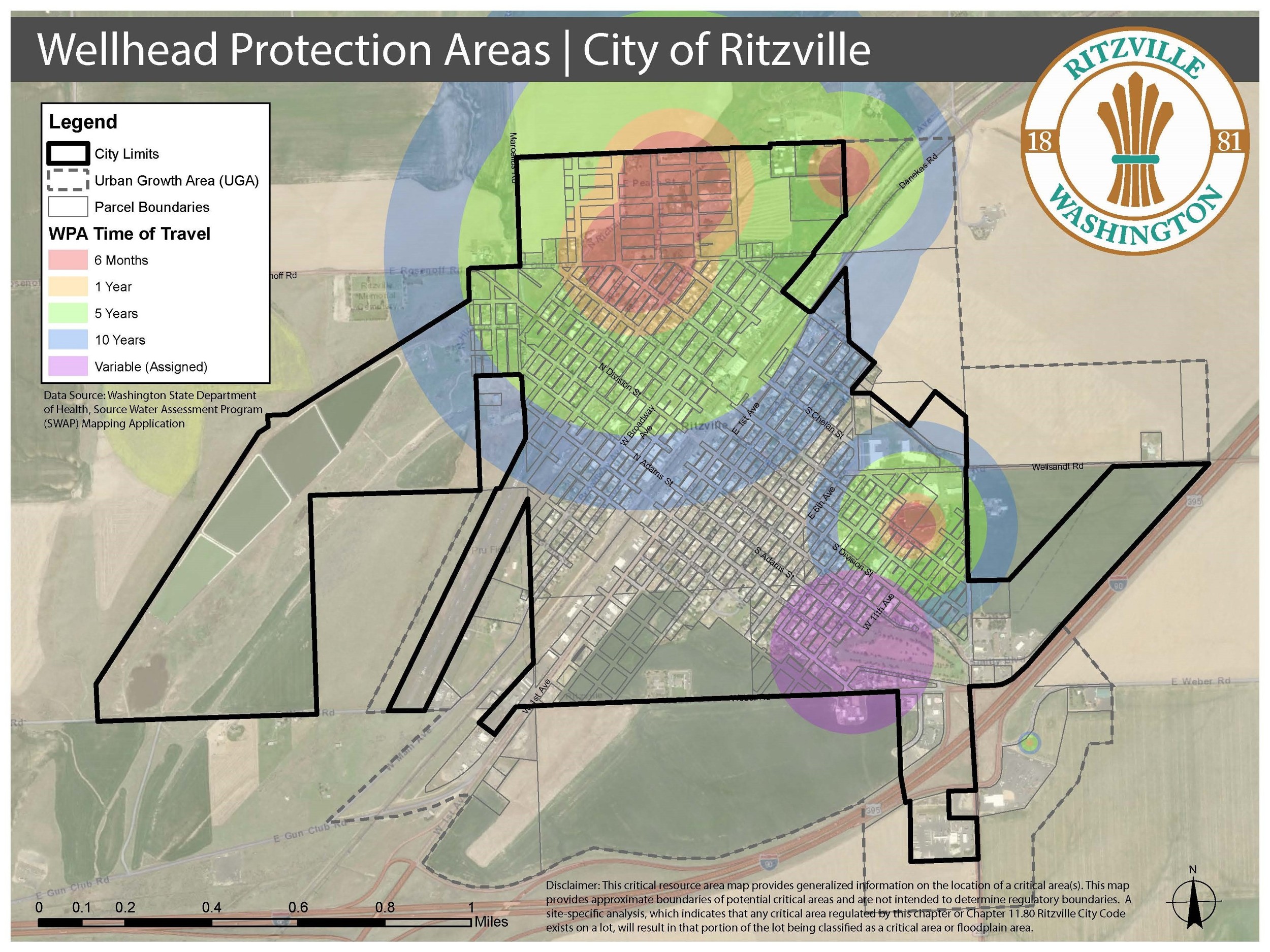
6. Source: Washington Department of Fish and Wildlife Test Map.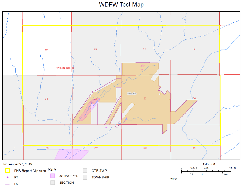
(Ord. 2143 § 1 (Att. A), 2020).
Code reviser’s note: This section was amended per the city’s request to remove the definitions of “major development” and “minor development” for consistency with the rest of Ord. 2143.
Code reviser’s note: This section was amended per the city’s request to remove references to “major development” and “minor development” for consistency with the rest of Ord. 2143.
Code reviser’s note: This section was amended per the city’s request to remove the definitions of “major development” and “minor development” for consistency with the rest of Ord. 2143.
Code reviser’s note: This section was amended per the city’s request to remove the subsection referring to the credit/debit tool, as there is no section for credits and debits for compensatory mitigation.
Code reviser’s note: Ord. 2143 included this section as 11.75.096. It has been editorially renumbered to avoid duplication of numbering and to preserve numeric order.
Code reviser’s note: This section was amended per the city’s request to remove the definitions of “major development” and “minor development” for consistency with the rest of Ord. 2143.