


Chapter 15.12
FLOOD HAZARD CONTROL REGULATIONS
Sections:
15.12.010 Statement of purpose.
15.12.020 Methods of reducing flood losses.
15.12.060 Flood development permits, variances and appeals.
15.12.070 Provisions for flood hazard reduction.
15.12.090 AE zones with base flood elevations but no floodways.
15.12.100 Coastal high hazard areas.
15.12.010 Statement of purpose.
It is the purpose of this chapter to promote the public health, safety, and general welfare; reduce the annual cost of flood insurance; and minimize public and private losses due to flood conditions in specific areas by provisions designed:
A. To protect human life and health;
B. To minimize expenditure of public money and costly flood control projects;
C. To minimize the need for rescue and relief efforts associated with flooding that are generally undertaken at the expense of the general public;
D. To minimize prolonged business interruptions;
E. To minimize damage to public facilities and utilities such as water and gas mains, electric, telephone and sewer lines, streets, and bridges located in areas of special flood hazard;
F. To help maintain a stable tax base by providing for the sound use and development of areas of special flood hazard so as to minimize future flood blight areas;
G. To ensure that potential buyers are notified that property is in an area of special flood hazard;
H. To ensure that those who occupy the areas of special flood hazard assume responsibility for their actions. (Ord. 13-2018 § 2)
15.12.020 Methods of reducing flood losses.
In order to accomplish its purposes, this chapter establishes methods and provisions for:
A. Restricting or prohibiting uses which are dangerous to health, safety, and property due to water or erosion hazards, or which result in damaging increases in erosion or in flood heights or velocities;
B. Requiring that uses vulnerable to floods, including facilities which serve such uses, be protected against flood damage at the time of initial construction;
C. Controlling the alteration of natural floodplains, stream channels, and natural protective barriers, which help accommodate or channel floodwaters;
D. Controlling filling, grading, dredging, and other development which may increase flood damage; and
E. Preventing or regulating the construction of flood barriers that unnaturally divert floodwaters or may increase flood hazards in other areas. (Ord. 13-2018 § 3)
15.12.030 Definitions.
“Appeals” means a request for a review of the interpretation of any provision of this chapter or a request for a variance.
“Areas of special flood hazard” means the land in the floodplain within a community subject to a one percent or greater chance of flooding in any given year. Designation on Flood Insurance Rate Maps always includes the letter A or V.
1. Areas of special flood hazard with the designation “A” are areas subject to inundation by the one-percent-annual-chance flood event, also known as the “100-year floodplain,” that have been defined using approximate methodologies. Because detailed hydraulic analyses have not been performed, no base flood elevations (BFE) or flood depths are shown. Properties in designation A are considered to be at a high risk of flooding under the National Flood Insurance Program.
2. Areas of special flood hazard with the designation “AE” are areas subject to inundation by the one-percent-annual-chance flood event, also known as the “100-year floodplain,” and where predicted floodwater levels have been established. Properties in Zone AE are considered to be at high risk of flooding under the National Flood Insurance Program.
3. Areas of special flood hazard with the designation “VE” are areas subject to inundation by the one-percent-annual-chance flood event, also known as the “100-year floodplain,” with additional hazards due to storm-induced velocity wave action. Base flood elevations derived from detailed hydraulic analyses are shown on the map. Properties in VE designation are considered to be at very high risk of flooding and flood related damage under the National Flood Insurance Program.
“Base flood” means the flood having a one percent chance of being equaled or exceeded in any given year (also referred to as the “100-year flood”). Designated on Flood Insurance Rate Maps by the letter A or V.
“Basement” means any area of the building having its floor subgrade (below ground level) on all sides.
“Breakaway wall” means a wall that is not part of the structural support of the building and is intended through its design and construction to collapse under specific lateral loading forces, without causing damage to the elevated portion of the building or supporting foundation system.
“Coastal high hazard area” means an area of special flood hazard extending from offshore to the inland limit of a primary frontal dune along an open coast and any other area subject to high velocity wave action from storms or seismic sources. The area is designated on the FIRM as Zone V1-30, VE or V.
“Critical facility” means a facility for which even a slight chance of flooding might be too great. Critical facilities include (but are not limited to) schools, nursing homes, hospitals, police, fire and emergency response installations, and installations which produce, use, or store hazardous materials or hazardous waste.
“Development” means any manmade change to improved or unimproved real estate, including but not limited to buildings or other structures, mining, dredging, filling, grading, paving, excavation or drilling operations or storage of equipment or materials located within the area of special flood hazard.
“Elevated building” means, for insurance purposes, a nonbasement building that has its lowest elevated floor raised above ground level by foundation walls, shear walls, posts, piers, pilings, or columns.
“Elevation certificate” means the official Federal Emergency Management Agency (FEMA) form (Form 086-0-33, or as may be subsequently revised or superseded) used to track development, provide elevation information necessary to ensure compliance with community floodplain management ordinances, and determine the proper insurance premium rate with Section B completed by the floodplain administrator.
“Existing manufactured home park or subdivision” means a manufactured home park or subdivision for which the construction of facilities for servicing the lots on which the manufactured homes are to be affixed (including, at a minimum, the installation of utilities, the construction of streets, and either final site grading or the pouring of concrete pads) is completed before June 26, 2018.
“Expansion to an existing manufactured home park or subdivision” means the preparation of additional sites by the construction of facilities for servicing the lots on which the manufactured homes are to be affixed (including the installation of utilities, the construction of streets, and either final site grading or the pouring of concrete pads).
“Flood” or “flooding” means a general and temporary condition of partial or complete inundation of normally dry land areas from:
1. The overflow of inland or tidal waters; and/or
2. The unusual and rapid accumulation or runoff of surface waters from any source.
“Flood Insurance Rate Map (FIRM)” means the official map on which the Federal Insurance and Mitigation Administration has delineated both the areas of special flood hazards and the risk premium zones applicable to the community.
“Flood Insurance Study (FIS)” means the official report provided by the Federal Insurance and Mitigation Administration that includes flood profiles, the Flood Insurance Rate Maps, and the water surface elevation of the base flood.
“Floodway” means the channel of a river or other watercourse and the adjacent land areas that must be reserved in order to discharge the base flood without cumulatively increasing the water surface elevation more than one foot. The floodway is established by the Federal Insurance and Mitigation Administration on its Flood Insurance Rate Maps (FIRMs). It does not include lands that can be reasonably expected to be protected from floodwaters by flood control devices maintained by or maintained under license from the federal government, the state or a political subdivision of the state.
“Increased cost of compliance (ICC)” means a flood insurance claim payment up to $30,000 directly to a property owner for the cost to comply with floodplain management regulations after a direct physical loss caused by a flood. Eligibility for an ICC claim can be through a single instance of “substantial damage” or as a result of “cumulative substantial damage.”
“Lowest floor” means the lowest floor of the lowest enclosed area (including basement). An unfinished or flood resistant enclosure, usable solely for parking of vehicles, building access, or storage in an area other than a basement area, is not considered a building’s lowest floor; provided, that such enclosure is not built so as to render the structure in violation of the applicable nonelevation design requirements of SJCC 15.12.080(A)(2) (i.e., provided there are adequate flood ventilation openings).
“Manufactured home” means a structure, transportable in one or more sections, which is built on a permanent chassis and is designed for use with or without a permanent foundation when attached to the required utilities. The term “manufactured home” does not include a recreational vehicle.
“Manufactured home park or subdivision” means a parcel (or contiguous parcels) of land divided into two or more manufactured home lots for rent or sale.
“Market value” means current value for affected structures as determined by the County assessor’s office.
“Mean sea level” means the data used in the current Flood Insurance Study (FIS) and referenced on the adopted Flood Insurance Rate Maps (FIRMs).
“New construction” means structures for which the start of construction commenced on or after June 26, 2018.
“New manufactured home park or subdivision” means a manufactured home park or subdivision for which the construction of facilities for servicing the lots on which the manufactured homes are to be affixed (including, at a minimum, the installation of utilities, the construction of streets, and either final site grading or the pouring of concrete pads) is completed on or after June 26, 2018.
“Recreational vehicle” means a vehicle:
1. Built on a single chassis;
2. Four hundred square feet or less when measured at the largest horizontal projection;
3. Designed to be self-propelled or permanently towable by a light duty truck; and
4. Designed primarily not for use as a permanent dwelling but as temporary living quarters for recreational, camping, travel, or seasonal use.
“Start of construction” includes substantial improvement, and means the date the building permit was issued, provided the actual start of construction, repair, reconstruction, placement or other improvement was within 180 days of the permit date. The “actual start” means either the first placement of permanent construction of a structure on a site, such as the pouring of slab or footings, the installation of piles, the construction of columns, or any work beyond the stage of excavation; or the placement of a manufactured home on a foundation. Permanent construction does not include land preparation, such as clearing, grading and filling; nor does it include the installation of streets and/or walkways; nor does it include excavation for a basement, footings, piers, or foundations or the erection of temporary forms; nor does it include the installation on the property of accessory buildings, such as garages or sheds not occupied as dwelling units or not part of the main structure. For a substantial improvement, the “actual start of construction” means the first alteration of any wall, ceiling, floor, or other structural part of a building, whether or not that alteration affects the external dimensions of the building.
“Structure” means a walled and roofed building, including a gas or liquid storage tank that is principally above ground.
“Substantial damage” means damage of any origin sustained by a structure whereby the cost of restoring the structure to its before-damaged condition would equal or exceed 50 percent of the market value of the structure before the damage occurred.
“Substantial improvement” means any repair, reconstruction, or improvement of a structure, the cost of which equals or exceeds 50 percent of the market value of the structure either:
1. Before the improvement or repair is started; or
2. If the structure has been damaged and is being restored, before the damage occurred. For the purposes of this definition, “substantial improvement” is considered to occur when the first alteration of any wall, ceiling, floor, or other structural part of the building commences, whether or not that alteration affects the external dimensions of the structure.
The term can exclude:
1. Any project for improvement of a structure to correct pre-cited existing violations of state or local health, sanitary, or safety code specifications which have been previously identified by the local code enforcement official and which are the minimum necessary to assure safe living conditions; or
2. Any alteration of a structure listed on the National Register of Historic Places or a state inventory of historic places.
“Variance” means a grant of relief from the requirements of this chapter that permits construction in a manner that would otherwise be prohibited by this chapter. (Ord. 8-2020 § 15; Ord. 13-2018 § 4)
15.12.040 General provisions.
A. Lands to Which This Chapter Applies. This chapter applies to all areas of special flood hazards within the jurisdiction of San Juan County.
B. Basis for Establishing the Areas of Special Flood Hazard. The areas of special flood hazard identified by the Federal Insurance Administration in a scientific and engineering report entitled “The Flood Insurance Study for San Juan County, Washington and Incorporated Areas” dated June 20, 2018, and any revisions thereto, with an accompanying Flood Insurance Rate Map (FIRM), and any revisions thereto, are hereby adopted by reference and declared to be a part of this chapter. The Flood Insurance Study and the FIRM are on file at the Department of Community Development, San Juan County, 135 Rhone Street, Friday Harbor, WA 98250. The best available information for flood hazard area identification as outlined in SJCC 15.12.050(B)(3) shall be the basis for regulation until a new FIRM is issued that incorporates data utilized under SJCC 15.12.050(B)(3).
C. Penalties for Noncompliance. No structure or land shall hereafter be constructed, located, extended, converted, or altered without full compliance with the terms of this chapter and other applicable regulations. Violations of the provisions of this chapter by failure to comply with any of its requirements (including violations of conditions and safeguards established in connection with conditions) shall be subject to the enforcement provisions of Chapter 18.100 SJCC. (Ord. 13-2018 § 5)
15.12.050 Administration.
A. Designation of the Floodplain Administrator. The director of San Juan County department of community development is hereby appointed as the County’s floodplain administrator, whose role is to administer and implement this chapter by granting or denying flood development permit applications in accordance with its provisions.
B. Duties and Responsibilities of the Floodplain Administrator. Duties of the floodplain administrator shall include, but not be limited to:
1. Review all development permits to determine that the permit requirements of this chapter have been satisfied;
2. Review all development permits to determine that all necessary permits have been obtained from those federal, state or local government agencies from which prior approval is required;
3. When base flood elevation data has not been provided for A and V flood hazard zones, in accordance with SJCC 15.12.040(B), the floodplain administrator shall obtain, review and reasonably utilize any base flood elevation data available from a federal, state or other source in order to administer SJCC 15.12.080.
C. Interpretation of FIRM Boundaries. The floodplain administrator is responsible for making interpretations, where needed, as to the exact location of the boundaries of the mapped areas of special flood hazards.
D. Alteration of Watercourses.
1. The floodplain administrator is responsible for notifying adjacent communities and the Washington State Department of Ecology prior to any alteration or relocation of a watercourse, and submitting evidence of such notification to the Federal Insurance Administration; and
2. Requiring maintenance is provided within the altered or relocated portion of said watercourse so that the flood carrying capacity is not diminished.
E. Information to Be Obtained and Maintained.
1. Where base flood elevation data is provided through the Flood Insurance Study, FIRM, or required as in subsection (B)(3) of this section, obtain and record the actual (as-built) elevation (in relation to mean sea level) of the lowest floor (including basement) of all new or substantially improved structures, and whether or not the structure contains a basement.
2. For all new or substantially improved floodproofed nonresidential structures where base flood elevation data is provided through the FIS, FIRM, or as required in subsection (B)(3) of this section:
a. Obtain and record the elevation (in relation to mean sea level) to which the structure was floodproofed; and
b. Maintain the floodproofing certifications as required in subsection (B)(3) of this section.
3. Maintain for public inspection all records pertaining to the provisions of this chapter.
4. In VE zones, obtain the elevation (in relation to mean sea level) of the bottom of the lowest horizontal structural member of the lowest floor (excluding pilings and columns) of all new and substantially improved structures in zones V1-V30, VE and V on the San Juan County FIRM and whether or not such structures contain a basement. The floodplain administrator shall maintain a record of all such information. (Ord. 13-2018 § 6)
15.12.060 Flood development permits, variances and appeals.
A. Flood Development Permit Required. A flood development permit shall be obtained before construction or development begins within any area of special flood hazard established in SJCC 15.12.040(B). The permit shall be for all structures including manufactured homes and for all development, as defined in SJCC 15.12.030 (Definitions).
B. Application for Flood Development Permit. Application for a flood development permit shall be made on forms furnished by San Juan County and may include, but not be limited to, plans in duplicate drawn to scale showing the nature, location, dimensions, and elevations of the area in question; existing or proposed structures, fill, storage of materials, drainage facilities, and the location of the foregoing. The following information is required:
1. Elevation in relation to mean sea level of the lowest floor (including basement) of all structures recorded on a current elevation certificate (FF 086-0-33) with Section B completed by the floodplain administrator;
2. Elevation in relation to mean sea level to which any structure has been floodproofed;
3. Certification by a registered professional engineer or architect that the floodproofing methods for any nonresidential structure meet floodproofing criteria in SJCC 15.12.080(C);
4. Description of the extent to which a watercourse will be altered or relocated as a result of the proposed development; and
5. A habitat assessment demonstrating the project will have no adverse impacts to endangered species functions and values. The habitat assessment shall be compliant with Army Corps of Engineers and FEMA Region 10 floodplain assessment and mitigation guidance.
C. Appeals and Variances.
1. Decisions of the floodplain administrator may be appealed to the hearing examiner. Appeals to the hearing examiner are subject to the provisions of SJCC 18.80.140.
2. Requests for variances are heard by the hearing examiner and subject to the provisions of SJCC 18.80.100(B), (C) and (E).
D. Flood Development Permit Variances.
1. Flood development permit applicants may request a variance from only:
a. Elevation requirements for the lowest floor;
b. Elevation requirements for floodproofing; and
c. The type and extent of required floodproofing.
2. Applications for a variance from the development standards identified in subsection (D)(1) of this section are subject to the procedural requirements of SJCC 18.80.100 and the following criteria:
a. Generally, the only condition under which a variance from the elevation standard may be issued is for new construction and substantial improvements to be erected on a small or irregularly shaped lot contiguous to and surrounded by lots with existing structures constructed below the base flood level. As the lot size increases, the technical justification required for issuing the variance increases;
b. Flood development permit variances shall only be issued upon a determination that the variance is the minimum necessary, considering the flood hazard, to afford relief;
c. Flood development permit variances shall only be issued upon:
i. A showing of good and sufficient cause;
ii. A determination that failure to grant the variance would result in exceptional hardship to the applicant; and
iii. A determination that the variance will not result in increased flood heights, additional threats to public safety, extraordinary public expense, create nuisances, cause fraud on or victimization of the public, or conflict with existing local laws or ordinances;
d. Flood development permit variances may be issued for nonresidential buildings in very limited circumstances to allow a lesser degree of floodproofing than watertight or dry floodproofing, where it can be determined that such action will have low damage potential, complies with all other variance criteria except subsection (D)(2)(a) of this section, and otherwise complies with SJCC 15.12.070(A), (C) and (D);
e. Any applicant to whom a variance is granted shall be given written notice that the permitted structure will be built with its lowest floor below the base flood elevation and that the cost of flood insurance will be commensurate with the increased risk. (Ord. 13-2018 § 7)
15.12.070 Provisions for flood hazard reduction.
In all areas of special flood hazard the following standards are required:
A. Anchoring.
1. All new construction and substantial improvements shall be anchored to prevent flotation, collapse, or lateral movement of the structure.
2. All manufactured homes shall be anchored to prevent flotation, collapse, or lateral movement, and shall be installed using methods and practices that minimize flood damage. Anchoring methods may include, but are not limited to, the use of over-the-top or frame ties to ground anchors.
B. Construction Materials and Methods.
1. All new construction and substantial improvements shall be constructed with materials and utility equipment resistant to flood damage.
2. All new construction and substantial improvements shall be constructed using methods and practices that minimize flood damage.
3. Electrical, heating, ventilation, plumbing, and air conditioning equipment and other service facilities shall be designed and/or otherwise elevated or located so as to prevent water from entering or accumulating within the components during conditions of flooding. Locating such equipment below the base flood elevation may cause annual flood insurance premiums to be increased.
C. Utilities.
1. All new and replacement water supply systems shall be designed to minimize or eliminate infiltration of floodwaters into the systems.
2. New and replacement sanitary sewage systems shall be designed to minimize or eliminate infiltration of floodwaters into the systems and discharges from the systems into floodwaters.
3. On-site waste disposal systems shall be located to avoid impairment to them or contamination from them during flooding.
D. Subdivision Proposals.
1. All subdivision proposals shall be consistent with the need to minimize flood damage.
2. All subdivision proposals shall have public utilities and facilities, such as sewer, gas, electrical, and water systems located and constructed to minimize or eliminate flood damage.
3. All subdivision proposals shall have adequate drainage provided to reduce exposure to flood damage.
4. Where base flood elevation data has not been provided or is not available from another authoritative source, it shall be generated for subdivision proposals and other proposed developments which contain at least 50 lots or five acres (whichever is less).
E. Review of Building Permits. Where elevation data is not available either through the Flood Insurance Study, FIRM, or from SJCC 15.12.050(B)(3), applications for building permits shall be reviewed by the floodplain administrator to assure that proposed construction will be reasonably safe from flooding. The test of reasonableness is a local judgment and includes use of historical data, high water marks, photographs of past flooding, etc., where available. Failure to elevate at least two feet above the highest adjacent grade in these zones may result in higher insurance rates. (Ord. 13-2018 § 8)
15.12.080 Specific standards.
In all areas of special flood hazards where base flood elevation data has been provided as set forth in SJCC 15.12.040(B) or 15.12.050(B)(3), the following standards are required:
A. Residential Construction.
1. New construction and substantial improvement of any residential structure shall have the lowest floor, including basement, one foot or more or above the base flood elevation (BFE).
2. Fully enclosed areas below the lowest floor that are subject to flooding are prohibited, or shall be designed to automatically equalize hydrostatic flood forces on exterior walls by allowing for the entry and exit of floodwaters. Designs for meeting this requirement must either be certified by a registered professional engineer or architect or must meet or exceed the following minimum criteria:
a. A minimum of two openings having a total net area of not less than one square inch for every square foot of enclosed area subject to flooding shall be provided. Openings may be equipped with screens, louvers, or other coverings or devices provided that they permit the automatic entry and exit of floodwaters; and
b. The bottom of all openings shall be no higher than one foot above grade.
Figure 1 – Preferred Residential Construction Standard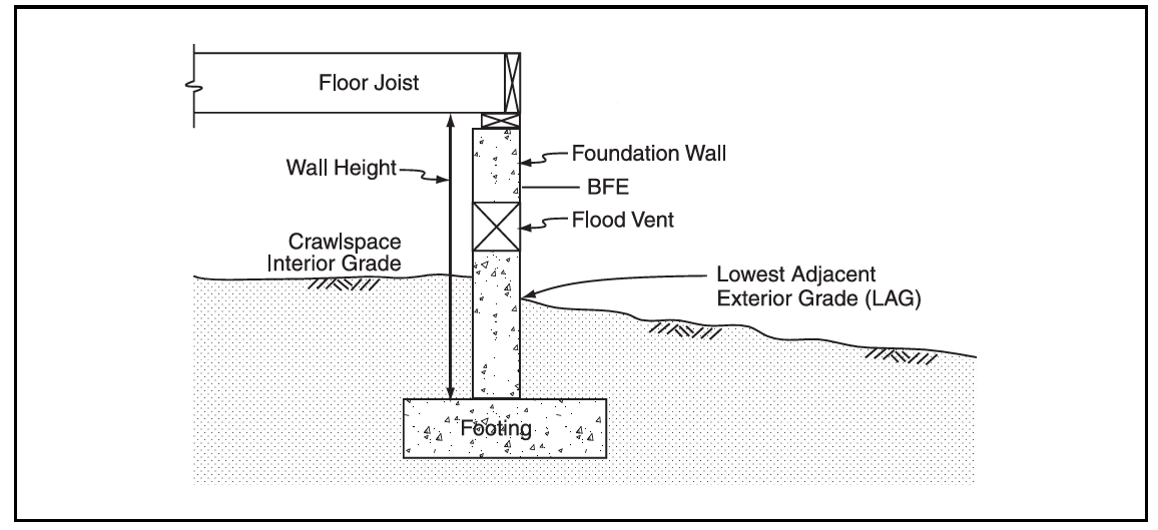
B. Subgrade Crawlspaces.
1. The interior grade of a crawlspace below the BFE shall not be more than two feet below the lowest adjacent exterior grade (LAG).
2. The height of the subgrade crawlspace, measured from the interior grade of the crawlspace to the top of the crawlspace foundation wall shall not exceed four feet (shown as L in Figure 2) at any point.
3. There must be an adequate drainage system removing floodwaters from the interior area of the crawlspace. The enclosed area should be drained within a reasonable time after a flood event. The type of drainage system will vary because of the site gradient and other drainage characteristics, such as soil types. Possible options include natural drainage through porous, well-drained soils and drainage systems such as perforated pipes, drainage tiles, or gravel or crushed stone drainage by gravity or mechanical means.
4. The velocity of floodwaters at the site shall not exceed five feet per second for any crawlspace. For velocities in excess of five feet per second, other foundation types shall be used.
5. Subgrade crawlspace construction in accordance with requirements of subsections (B)(1) through (B)(4) of this section will not be considered basements.
6. Buildings constructed with subgrade crawlspace in the area of special flood hazard may have a 20 percent increase in flood insurance premiums.
Figure 2 – Requirements for Subgrade Crawlspace Construction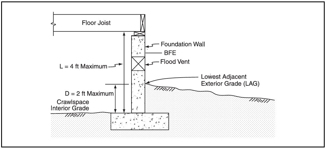
C. Nonresidential Construction. New construction and substantial improvement of any commercial, industrial or other nonresidential structure shall either have the lowest floor, including basement, elevated one foot or more above the base flood elevation (and if enclosed, the area must be consistent with the hydrostatic equalization provisions of subsection (A)(2) of this section); or, together with attendant utility and sanitary facilities, shall:
1. Be floodproofed so that below one foot or more above the base flood level the structure is watertight with walls substantially impermeable to the passage of water;
2. Have structural components capable of resisting hydrostatic and hydrodynamic loads and effects of buoyancy;
3. Be certified by a registered professional engineer or architect that the design and methods of construction are in accordance with accepted standards of practice for meeting provisions of this subsection based on their development and/or review of the structural design, specifications and plans. Such certifications shall be provided to the floodplain administrator as set forth in SJCC 15.12.050(E)(2).
D. Manufactured Homes. All manufactured homes in the floodplain to be placed or substantially improved on sites shall be elevated on a permanent foundation such that the lowest floor of the manufactured home is elevated one foot or more above the base flood elevation and be securely anchored to an adequately anchored foundation system to resist flotation, collapse and lateral movement.
E. Recreational Vehicles. Recreational vehicles placed on sites are required to either:
1. Be on the site for fewer than 180 days; or
2. Be fully licensed and ready for highway use, on wheels or jacking system, attached to the site only by quick-disconnect type utilities and security devices, and have no permanently attached additions; or
3. Meet the requirements of subsection (D) of this section and the elevation and anchoring requirements for manufactured homes. (Ord. 13-2018 § 9)
15.12.090 AE zones with base flood elevations but no floodways.
In areas with base flood elevations (but a regulatory floodway has not been designated), no new construction, substantial improvements, or other development (including fill) shall be permitted within zone AE on the community’s FIRM, unless it is demonstrated that the cumulative effect of the proposed development, when combined with all other existing and anticipated development, will not increase the water surface elevation of the base flood more than one foot at any point within the community. (Ord. 13-2018 § 10)
15.12.100 Coastal high hazard areas.
SJCC 15.12.040(B) identifies coastal high hazard areas designated as zone VE. These areas have special flood hazards associated with high velocity waters from surges and, therefore, in addition to meeting all provisions in this chapter, the following requirements also apply:
A. All new construction and substantial improvements in the VE zone on the County’s FIRM shall be elevated on pilings and columns so that:
1. The bottom of the lowest horizontal structural member of the lowest floor (excluding the pilings or columns) is elevated one foot or more above the base flood level;
2. The pile or column foundation and structure attached thereto is anchored to resist flotation, collapse and lateral movement due to the effects of wind and water loads acting simultaneously on all building components. Wind and water loading values shall each have a one percent chance of being equaled or exceeded in any given year (100-year mean recurrence interval);
B. A registered professional engineer or architect shall develop or review the structural design, specifications and plans for the construction, and shall certify that the design and methods of construction to be used are in accordance with accepted standards of practice for meeting the provisions of subsections (A)(1) and (A)(2) of this section.
C. All new construction within the VE zone on the adopted FIRM shall be located landward of the reach of mean high tide.
D. All new construction and substantial improvements within the VE zone on the County’s FIRM shall have the space below the lowest floor either free of obstruction or constructed with nonsupporting breakaway walls, open wood latticework, or insect screening intended to collapse under wind and water loads without causing collapse, displacement, or other structural damage to the elevated portion of the building or supporting foundation system. For the purposes of this section, a breakaway wall shall have a design safe loading resistance of not less than 10 and no more than 20 pounds per square foot.
E. Use of breakaway walls which exceed a design safe loading resistance of 20 pounds per square foot (either by design or when so required by local or state codes) may be permitted only if a registered professional engineer or architect certifies that the design proposed meets the following conditions:
1. Breakaway wall collapse shall be from water load less than that which would occur during the base flood; and
2. The elevated portion of the building and supporting foundation system shall not be subject to collapse, displacement, or other structural damage due to the effects of wind and water loads acting simultaneously on all building components (structural and non-structural). Maximum wind and water loading values to be used in this determination shall each have a one percent chance of being equaled or exceeded in any given year (100-year mean recurrence interval).
F. If breakaway walls are utilized, such enclosed space shall be usable solely for parking of vehicles, building access, or storage. Such space shall not be used for human habitation.
G. The use of fill for structural support of buildings within the VE zone on the County’s FIRM is prohibited.
H. Manmade alteration of sand dunes within the VE zone on the County’s FIRM which would increase potential flood damage is prohibited.
I. All manufactured homes to be placed or substantially improved within the VE zone on the County’s FIRM on sites:
1. Outside of a manufactured home park or subdivision;
2. In a new manufactured home park or subdivision;
3. In an expansion to an existing manufactured home park or subdivision; or
4. In an existing manufactured home park or subdivision on which a manufactured home has incurred “substantial damage” as the result of a flood.
Subsections (I)(1) through (I)(4) of this section shall meet the standards of subsections (A) through (I) of this section.
5. Manufactured homes placed or substantially improved on other sites in an existing manufactured home park or subdivision within the VE zone on the FIRM shall meet the requirements of SJCC 15.12.080(D).
J. Recreational vehicles placed on sites within the VE zone on the county’s FIRM shall either:
1. Be on the site for fewer than 180 consecutive days; or
2. Be fully licensed and ready for highway use, on its wheels or jacking system, attached to the site only by quick-disconnect type utilities and security devices, and have no permanently attached additions; or
3. Meet the requirements of SJCC 15.12.070(A)(2) and the provisions of subsections (A) through (H) of this section. (Ord. 13-2018 § 11)
15.12.110 Critical facility.
Construction of new critical facilities shall be, to the extent possible, located outside the limits of the special flood hazard area. Construction of new critical facilities shall be permissible within the SFHA if no feasible alternative site is available. Critical facilities constructed within the SFHA shall have the lowest floor elevated three feet above BFE or to the height of the 500-year flood, whichever is higher. Access to and from the critical facility should also be protected to the height utilized above. Floodproofing and sealing measures must be taken to ensure that toxic substances will not be displaced by or released into floodwaters. Access routes elevated to or above the level of the base flood elevation shall be provided to all critical facilities to the extent possible. (Ord. 13-2018 § 12)