


Chapter 18.50
SHORELINE MASTER PROGRAM
Sections:
Article I. General Provisions
18.50.010 Purpose of the Shoreline Master Program (SMP).
18.50.030 General applicability.
18.50.050 Exemptions from substantial development permit requirements.
18.50.060 Shoreline modification regulations – General shoreline modification activities.
Article II. General Regulations
18.50.090 Nonconforming structures, uses, and activities.
18.50.100 Archaeological and historic resources.
18.50.110 Clearing, grading, fill, excavation and vegetation management.
18.50.120 General environmental protection.
18.50.140 Mitigation of adverse impacts to shoreline ecological functions.
18.50.160 Mitigation plan approval criteria.
18.50.170 Flood hazard reduction.
Article III. Regulations for Specific Developments, Uses, Structures and Activities
18.50.210 General regulations.
18.50.250 Regulations – Boating facilities – General.
18.50.270 Regulations – Commercial/industrial docks and piers.
18.50.280 Regulations – Marinas.
18.50.290 Regulations – Ramps (including marine railways).
18.50.300 Regulations – Mooring buoys.
18.50.310 Regulations – Private recreational floats.
18.50.320 Replacement, repair, and expansion of boating facilities, docks, piers, floats and ramps.
18.50.330 Boating facilities, docks, piers, floats, and ramps – Submittal requirements.
18.50.340 Breakwaters, jetties, and groins.
18.50.350 Hard and soft structural shoreline stabilization measures – General regulations.
18.50.360 Hard and soft structural shoreline stabilization measures order of preference.
18.50.370 General design standards for hard and soft shoreline stabilization measures.
18.50.380 Hard structural shoreline stabilization measures design standards.
18.50.390 Soft structural shoreline stabilization design standards.
18.50.400 Regulations – Enlargement of hard or soft structural shoreline stabilization measures.
18.50.420 Hard or soft shoreline stabilization measures – Additional submittal requirements.
18.50.430 Commercial developments and uses.
18.50.440 Dredging and dredge material disposal.
18.50.460 Industrial developments and uses.
18.50.470 Institutional developments and uses.
18.50.480 Log transfer sites, facilities and storage.
18.50.500 Private pedestrian pathways, stairways and ramps – General regulations.
18.50.530 Shoreline land divisions.
18.50.540 Residential development.
18.50.550 Transportation facilities and parking.
18.50.570 Shoreline essential public facilities.
18.50.600 Shoreline developments, uses, structures and activities by designation.
Article I. General Provisions
18.50.010 Purpose of the Shoreline Master Program (SMP).
A. The State Shoreline Management Act (SMA) was developed and adopted to protect “the most valuable and fragile of [the state’s] natural resources” from the “inherent harm in uncoordinated and piecemeal development of the state’s shorelines.” The SMA in Chapter 90.58 RCW contains three distinct but related priorities:
1. The promotion of shoreline uses that are both water-oriented and appropriate for the broader environmental context. Developments such as recreational areas, water-dependent businesses such as marinas, and single-family residences are considered priority uses provided they are constructed in a manner consistent with shoreline ecology.
2. The SMA requires local governments to take an active role in protecting the shoreline ecology: the water, the land, the vegetation and the wildlife. The state guidelines are explicit: “Local master programs shall include regulations and mitigation standards ensuring that each permitted development will not cause a net loss of ecological functions of the shoreline.” (WAC 173-26-186(8)(b)(i).)
3. The SMA also promotes public access to the shoreline by requiring protection of existing public access features and requiring certain types of new development to include public access.
B. The SMP regulations apply to individual projects and impacts of shoreline development are evaluated on a project-by-project basis. However, the SMP goals and policies, shoreline designations, regulations and the restoration plan are comprehensively structured to achieve no net loss of shoreline ecological functions as a whole in San Juan County. (Ord. 1-2016 § 7)
18.50.020 General.
A. Title. This chapter of the San Juan County Unified Development Code (UDC), together with Element 3 of the Comprehensive Plan, the official maps and common descriptions of shoreline designation boundaries that do not follow property lines (Ordinance 1-2016, Exhibit D), Section 2(B) Figures 130-6, 130-7 of the Eastsound Subarea Plan, SJCC 18.30.480, the Eastsound Waterfront Access Plan, and SJCC 18.80.110, is the Shoreline Master Program (SMP) for San Juan County, Washington.
B. Short Title. The short title of this chapter and Element 3 of the Comprehensive Plan is the “SMP.”
C. Authority.
1. The provisions of this chapter are adopted pursuant to RCW 90.58.140(1) through (3) and 90.58.200, the SMA, Chapters 173-26 and 173-27 WAC, and Element 3 of the Comprehensive Plan. Except when specifically exempted by statute, all proposed uses and development occurring within shoreline jurisdiction must conform to Chapter 90.58 RCW, the SMA, and this SMP.
2. As provided in RCW 90.58.900, the SMA is exempt from the rule of strict construction. The SMA and the SMP are liberally construed to give full effect to the purposes, goals, objectives, and policies for which the SMA and this SMP were enacted and adopted.
3. The SMA and the SMP comprise the basic state and local law regulating the use of shorelines in the County. Unless specifically provided otherwise, if the provisions of the SMP conflict with other applicable state or local policies, subarea plans, or other regulations, the most restrictive regulation controls.
D. Official Map.
1. The official maps are part of the SMP. The map shows all areas of the County under the jurisdiction of the SMP and the official shoreline designations established by Element 3 of the Comprehensive Plan for all affected lands and waters.
2. There are four official copies of the map. Two are maintained by the department, one is archived by the San Juan County auditor, and one is submitted to the Washington Department of Ecology (WDOE). Amendments to the map are promptly recorded on the official copies.
3. No part of the map may be altered or amended without the approval of the WDOE, except those changes provided for in subsection (D)(4) of this section.
4. Where questions arise regarding the precise boundaries of any shoreline designation, the director will make the final determination, subject to the provisions of SJCC 18.80.140. Unofficial copies of the map may be prepared for administrative purposes as needed.
5. All areas that are not mapped in shoreline jurisdiction, but meet the jurisdictional criteria in RCW 90.58.030(f) per WAC 173-26-211(2)(e), are assigned a conservancy designation until the shoreline can be redesignated through an SMP amendment.
E. Responsibilities of Department Director and Planning Commission.
1. Director.
a. The director:
i. Makes written recommendations to the decision-maker regarding shoreline permit applications, provides technical and administrative assistance to the hearing examiner as required, and provides such technical assistance to the planning commission and County council as may be needed; and
ii. Is the local decision-maker on shoreline substantial development permit applications for public pedestrian trails and residential accessory structures (excluding shoreline stabilization, boathouses and overwater structures) that do not meet an exemption threshold in SJCC 18.50.050; and
b. The director has the overall administrative responsibility for the SMP including:
i. Establishing the procedures and preparing the forms deemed essential for the administration of the SMP;
ii. Advising applicants for permits and other interested persons of the policies, regulations, and procedures established by the SMP and the SMA;
iii. Making administrative interpretations of the SMP, as necessary;
iv. Collecting required fees;
v. Determining that applications are proper and complete prior to review;
vi. Making field inspections; and
vii. Seeking compliance with the provisions of the SMP and the SMA and with conditions attached to a shoreline permit issued by the County.
2. The department and planning commission have authority to review and recommend revisions to the SMP.
3. The department shall document all project review actions in the shoreline jurisdiction and evaluate the cumulative effects of such development on shoreline conditions. The cumulative effects evaluation shall be conducted every four years and consider:
a. Permit applications, decisions, environmental reports, and other data from authorized shoreline exemptions and permits and GIS maps;
b. Aerial and LIDAR photographs;
c. Other available data; and
d. Field observations. (Ord. 8-2020 § 4; Ord. 21-2018 § 2; Ord. 11-2017 § 3; Ord. 1-2016 § 8)
18.50.030 General applicability.
A. This SMP provides land use regulations to implement the goals and policies of the Comprehensive Plan Element 3, SMP. These regulations apply to all of the land and waters of the County that fall under the jurisdiction of the SMA. These regulations do not apply to development and uses beyond the jurisdictional limits of the SMA unless a proposed development involves both jurisdictional and nonjurisdictional land and the upslope land development is likely to adversely affect shoreline ecological functions.
B. This SMP applies to every person, individual, firm, partnership, association, organization, corporation, local or state governmental agency, public or municipal corporation, or other nonfederal entity that develops, owns, leases, or manages lands, wetlands, or waters that fall under the jurisdiction of the SMA, except for the right of any person established by treaty to which the United States is a party.
C. Applicability to Federal Agencies.
1. Federal agencies are subject to this SMP and the SMA, as provided by the Coastal Zone Management Act (16 U.S.C. 1451 et seq.; WAC 173-27-060(1)).
2. Those nonfederal lands lying within the exterior boundaries of federal lands and those federal lands leased to other persons, which fall within the definition of shorelands, shall be subject to the jurisdiction of Chapter 90.58 RCW. Areas and uses in those areas that are under exclusive federal jurisdiction as established through federal or state statutes are not subject to the jurisdiction of Chapter 90.58 RCW.
3. The shoreline permit system applies to development and uses undertaken on lands not federally owned but under lease, easement, license, or other similar property right of the federal government.
D. This SMP applies to all developments, uses, and structures, as well as activities regulated by SJCC 18.50.130. Unless otherwise authorized, shoreline development without a project permit, shoreline substantial development permit, shoreline conditional use permit, shoreline variance, or certificate of exemption is prohibited.
E. Developments Not Required to Obtain Shoreline Permits or Local Reviews. Requirements to obtain a substantial development permit, conditional use permit, variance, letter of exemption, or other review to implement the SMA do not apply to the following:
1. Remedial actions pursuant to RCW 90.58.355. Remedial actions conducted by any person at a facility pursuant to a consent decree, order, or agreed order issued pursuant to Chapter 70.105D RCW, or the WDOE when it conducts a remedial action under Chapter 70.105D RCW;
2. Boatyard improvements to meet National Pollutant Discharge Elimination System (NPDES) permit requirements pursuant to RCW 90.58.355. Any person installing site improvements for stormwater treatment in an existing boatyard facility needed to meet requirements of an NPDES stormwater general permit;
3. WSDOT facility maintenance and safety improvements pursuant to RCW 90.58.356. Washington State Department of Transportation projects and activities meeting the conditions of RCW 90.58.356;
4. Projects consistent with an environmental excellence program agreement pursuant to RCW 90.58.045; and
5. Projects authorized through the Washington Energy Facility Site Evaluation Council process pursuant to Chapter 80.50 RCW. (Ord. 8-2020 § 5; Ord. 11-2017 § 4; Ord. 1-2016 § 9)
18.50.040 Exemptions from shoreline substantial development permit requirements – General requirements.
A. Exemption from the shoreline substantial development permit requirements under this section does not constitute an exemption from the policies of the SMA, the regulations of this SMP, or other applicable County, state, or federal permit requirements.
B. Exemption procedures are provided in SJCC 18.80.110.6. Exemptions are construed narrowly in accordance with WAC 173-27-040(1)(a). If any part of a project is not eligible for an exemption, a shoreline substantial development permit is required for the entire project.
C. Certificates of exemption are required for certain developments under SJCC 18.50.050(B). A use classified as a conditional use, or a use not named or contemplated in this chapter, is allowed subject to a conditional use permit and is ineligible for a shoreline substantial development permit exemption.
D. The following developments, as defined in WAC 173-27-040, are not shoreline substantial developments and require a certificate of exemption when not considered as part of a larger project or development permit:
1. With the exception of docks, any development, use, structure or activity whose total cost or fair market value, whichever is higher, does not exceed the maximum exempt amount allowed by state law ($7,047 in September 2017) in accordance with WAC 173-27-040(2)(a), if such development does not materially interfere with the normal public use of the water or shorelines of the state. The total cost or fair market value of the development includes the fair market value of any donated, contributed or found labor, equipment, or materials.
2. Normal maintenance or repair of existing structures or developments including those damaged by fire, accident, or the elements in accordance with WAC 173-27-040(2)(b).
3. Construction of a protective structural shoreline stabilization measure associated with existing single-family residences in accordance with WAC 173-27-040(2)(c).
4. Emergency construction necessary to protect property from damage by the elements, in accordance with WAC 173-27-040(2)(d). Flooding or other seasonal events that can be anticipated and may occur but are not immediately imminent are not an emergency.
5. Construction and practices necessary for farming, irrigation, and ranching activities, including agricultural service roads and utilities on shorelands, construction and maintenance of a barn or similar agricultural structure and the construction and maintenance of irrigation structures such as head gates, pumping facilities, and irrigation channels in accordance with WAC 173-27-040(2)(e); provided, that a feedlot of any size, all processing plants, other activities of a commercial nature, and alteration of the contour of the shorelands by leveling or filling (other than that which results from normal cultivation) are not considered normal or necessary farming or ranching activities.
6. Construction or modification of navigational aids such as channel markers and anchor buoys in accordance with WAC 173-27-040(2)(f).
7. Construction of a single-family residence, including normal residential appurtenances, for the use of the beneficial owner and their family is exempt from shoreline substantial development permit requirements. For the purposes of this SMP, the beneficial owner is an individual who may be a land owner, lessee, contract purchaser, or a member of a family corporation, trust, or partnership, and who is related by blood, adoption, marriage or domestic partnership to all other members of the corporation, trust or partnership. For the construction of more than one single-family residence, a shoreline substantial development permit is required in accordance with WAC 173-27-040(2)(g). Exempt normal residential appurtenances are defined in SJCC 18.20.140 and regulated by SJCC 18.50.050.
8. Construction of a dock, including a community dock, designed for pleasure craft only, for the private, noncommercial use of the owner, lessee, or contract purchaser of single- and multiple-family residences in accordance with WAC 173-27-040(2)(h). This exception applies if either:
a. In salt waters, the fair market value of the dock does not exceed $2,500; or
b. In fresh waters, the fair market value of the dock does not exceed:
i. Twenty-two thousand five hundred dollars for docks that are constructed to replace existing docks, and are of equal or lesser square footage than the existing dock being replaced; or
ii. Eleven thousand two hundred dollars for all other docks constructed in fresh waters.
If subsequent construction occurs within five years of completion of prior construction, and the combined fair market value of the subsequent and prior construction exceeds the amount specified above, the subsequent construction is considered a substantial development.
9. Operation, maintenance, or construction of canals, waterways, drains, reservoirs, or other facilities that now exist or are hereafter created or developed as part of an irrigation system for the primary purpose of making use of the system waters, including return flow and artificially stored groundwater from the irrigation of lands in accordance with WAC 173-27-040(2)(i).
10. The marking of property lines or corners on state-owned lands, when such marking does not significantly interfere with normal public use of the surface of the water in accordance with WAC 173-27-040(2)(j).
11. Operation and maintenance of any system of dikes, ditches, drains, or other facilities existing on September 8, 1975, that were created, developed, or utilized primarily as part of an agricultural drainage or diking system in accordance with WAC 173-27-040(2)(k).
12. Site exploration and investigation activities that are prerequisite to preparation of an application for development authorization under this SMP in accordance with WAC 173-27-040(2)(m) if:
a. The activity does not interfere with the normal public use of the surface waters;
b. The activity will have no significant adverse impact on the environment such as fish, wildlife, fish or wildlife habitat, water quality, and aesthetic values;
c. The activity does not involve the installation of any structure, and upon completion of the activity the vegetation and land configuration of the site are restored to conditions existing before the activity;
d. A private entity seeking development authorization under this section first posts a financial guarantee or provides other evidence of financial responsibility to the County to ensure that the site is restored to preexisting condition; and
e. The activity is not subject to the permit requirements of RCW 90.58.550.
13. The process of removing or controlling an aquatic noxious weed, as defined in state law, through the use of herbicides or other treatment methods that are recommended in a final environmental impact statement published by the U.S. Department of Agriculture or the WDOE jointly with other state agencies under Chapter 43.21C RCW in accordance with WAC 173-27-040(2)(n). In order to qualify as exempt, noxious weed control must meet the following County requirements:
a. Aquatic weed control must only occur when native plant communities and associated habitats are threatened or where a water-dependent use is restricted by the presence of weeds. Aquatic weed control must occur in compliance with all other applicable laws and standards.
b. Aquatic weeds will be controlled by hand pulling or mechanical harvesting that does not disturb the sea bed, or entail placement of aqua-screens. If the action is being proposed for the retention of existing water depth for navigation, it is considered normal maintenance and repair.
c. The control of aquatic weeds by derooting, rotovating, or other methods that disturb the sea bed or benthos in order to maintain the pre-existing water depth for navigation in an area covered by a previous permit is considered normal maintenance and repair. The control of aquatic weeds by similar methods in any other circumstance requires a shoreline substantial development permit.
d. Use of herbicides to control aquatic weeds is prohibited except where no feasible alternative exists and weed control complies with all state rules and regulations.
14. Watershed restoration projects in accordance with WAC 173-27-040(2)(o) including a public or private project designed to improve fish or wildlife habitat or fish passage that conforms to the provisions of RCW 77.55.181.
15. Habitat enhancement projects that conform to the provisions of RCW 77.55.181 and 90.58.147 are consistent with local shoreline master programs. A public or private project that is designed to improve fish or wildlife habitat or fish passage is in accordance with WAC 173-27-040(2)(p) and RCW 77.55.181, when all of the following apply:
a. The project has been approved by the Washington Department of Fish and Wildlife (WDFW);
b. The project has received hydraulic project approval by the WDFW pursuant to Chapter 77.55 RCW; and
c. The County has determined that the project is substantially consistent with this SMP.
16. The external or internal retrofitting of an existing structure with the exclusive purpose of compliance with the Americans with Disabilities Act of 1990 (42 U.S.C. Section 12101 et seq.) or to otherwise provide physical access to the structure by individuals with disabilities. (Ord. 8-2020 § 6; Ord. 11-2017 § 5; Ord. 1-2016 § 10)
18.50.050 Exemptions from substantial development permit requirements.
A. Normal residential appurtenances are structures or developments that are necessarily connected to the use and enjoyment of a single-family residence and that are expressly defined in SJCC 18.20.140. Hard structural shoreline stabilization measures and other shoreline modifications or over-water structures are not considered normal appurtenant structures. Normal residential appurtenance exemptions also include:
1. Construction or renovation of structures with fair market value of less than the maximum value allowed by WAC 173-27-040(2)(a) ($7,047 in September 2017).
2. Private pedestrian pathways, stairways and ramps; provided, that a written certificate of exemption is obtained, and all of the following criteria are met:
a. The total cost or fair market value of the improvements does not exceed the maximum allowed by WAC 173-27-040(2)(a);
b. Roofs or roof covering materials such as awnings are not allowed for purposes of this exemption;
c. All materials must be finished in subdued natural earth colors;
d. No construction or placement seaward or below the OHWM is allowed unless the stairways or ramps are connected to an exempt or permitted dock;
e. No other shoreline access exists or is feasible;
f. The maximum vertical height of the stairway is 15 feet and the maximum width of the structure is five feet. One intermediate landing or platform with a maximum size of five feet by five feet is allowed. Stairways proposed for exposed areas of the shoreline are not allowed on rock faces or bluffs that exceed a 60-degree angle; and
g. The project complies with the bank stability and geologically hazardous area requirements of SJCC 18.50.130.
B. Certificates of Exemption.
1. The director may approve or deny applications for an exemption from a shoreline substantial development permit for uses and developments listed in SJCC 18.50.040 and subsection (A) of this section. Approved certificates must describe the specific exemption that is being applied to the development and indicate that a proposal is consistent with the SMP and the SMA. The certificate of exemption may contain conditions or mitigation measures required for consistency with the SMP and SMA. The denial of an exemption must include written findings. The director’s approval or denial of a certificate of exemption may be appealed under SJCC 18.80.140.
2. When not part of an approved development or project permit a certificate of exemption is required for:
a. Dredging;
b. Flood hazard control structures;
c. Archaeological or historic site alteration;
d. Clearing, grading, fill, excavation and vegetation removal;
e. Dock construction, repair, replacement, or enlargement;
f. Structural shoreline stabilization, repair, replacement, or enlargement;
g. Any residential, commercial or industrial development project within the natural and aquatic designations;
h. Small scale shellfish aquaculture consistent with the provisions of SJCC 18.50.230(B);
i. New temporary barge landing sites. Existing nonconforming temporary barge landing sites do not require a certificate of exemption if the proposed use is consistent with the historic transport of cargo at the site and frequency of the historic use; and
j. Private pedestrian pathways, stairways and ramps.
3. Whenever an exempt activity also requires an ACOE Section 10 permit under the Rivers and Harbors Act of 1899, or a Section 404 permit under the Federal Water Pollution Control Act of 1972, a copy of the certificate of exemption is sent to the applicant and the WDOE in accordance with WAC 173-27-050.
4. A certificate of exemption is not required for residential development, including normal residential appurtenant structures, when a project or development permit application is required.
5. A certificate of exemption is not required prior to emergency actions taken pursuant to WAC 173-27-040(2)(d). Post-emergency applications must be submitted in accordance with SJCC 18.35.030(A). (Ord. 8-2020 § 7; Ord. 11-2017 § 6; Ord. 1-2016 § 11)
18.50.060 Shoreline modification regulations – General shoreline modification activities.
A. Prior to undertaking any shoreline modification project, a shoreline substantial development permit, a shoreline variance, or a shoreline conditional use permit must be obtained. See the permit requirements for the specific type of shoreline modification in Table 18.50.600 and specific requirements by designation. Shoreline modifications including structural shoreline stabilization measures are allowed subject to the procedures and requirements in subsection (B) of this section.
B. General Standards.
1. If inventories of critical saltwater habitats are found to be incomplete, an inventory and assessment of the site and adjacent beach sections are required to identify these habitats and their functions. The methods and extent of the inventory shall be consistent with accepted research methodology in consultation with the WDOE’s technical assistance materials.
2. Shoreline modifications must be the minimum size necessary to achieve the intended purpose.
3. Shoreline modification applications must include adequate information demonstrating that the project meets all applicable requirements. At a minimum, the required information must include:
a. Construction materials (e.g., type, dimensions, design);
b. Method of construction and erosion control;
c. Location of project on lot;
d. Ordinary, mean low, and mean high water elevations;
e. The OHWM subject to verification by WDOE;
f. Net direction of littoral, drift and tidal currents (if any);
g. General direction and speed of prevailing winds and fetch when applicable;
h. Profile rendition of project including beach and building site landward of the OHWM;
i. Beach type, slope, and material;
j. Land type, slope, and material;
k. Soil types (NRCS);
l. Assessment of site stability before and after the project; and
m. Potential impacts upon shore processes and nearby properties.
4. Erosion must be controlled during the construction of shoreline modification projects and disturbed areas must be promptly revegetated after the project is completed. (Ord. 1-2016 §§ 64, 84(E))
18.50.070 Definitions.
The definitions for all terms used in this document have the meanings specified in Chapter 18.20 SJCC. If there is a conflict in interpretation, the terms used in Chapter 90.58 RCW and WAC 173-26-020 and 173-27-030 control. (Ord. 1-2016 § 12)
Article II. General Regulations
18.50.080 Administration.
A. All existing shoreline uses and activities, including those that do not require a shoreline substantial development permit, must conform to the SMA and the general and use-specific regulations of this SMP.
B. All shoreline modification activities, developments and vegetation removal are prohibited unless they support an allowable shoreline use that conforms to the provisions of this SMP.
C. Prohibited shoreline uses and modification activities are not eligible for shoreline variances or conditional use permits. (Ord. 1-2016 § 13)
18.50.090 Nonconforming structures, uses, and activities.
A. Except for structural shoreline stabilization measures (addressed in SJCC 18.50.410) and boating facilities, docks, piers, mooring and recreational floats (addressed in SJCC 18.50.320), any use or structure legally located within shoreline jurisdiction that was established before October 30, 2017, may be moved, replaced, redeveloped, expanded, or otherwise modified on the same parcel provided this work is consistent with the provisions of this section.
B. Movement, replacement, redevelopment, expansion or modification of structures may be allowed if the applicant demonstrates that the proposed action will not:
1. Result in a net loss of shoreline ecological functions;
2. Increase adverse impacts on shoreline critical areas;
3. Create a new nonconformance or increase the degree of inconsistency with the provisions of this SMP; or
4. Result in a hazard to people or property.
See Figure 18.50.090 below.
C. The applicant must demonstrate no net loss of shoreline ecological functions based upon an analysis that addresses any:
1. Increase in the quantity of pollutants from the site;
2. Increase in the quantity of surface runoff from the site;
3. Decrease in trees and other vegetation within buffers and tree protection zones;
4. Decrease in the stability of the site and other properties; and
5. Changes to the transport of sediment to and within nearshore areas.
D. Upon submittal of a written request for administrative determination, the director may approve minor changes to the prior footprint in order to further protect natural or verified cultural and historic resources after making written findings.
E. Complete application(s) for project or development permits for replacement structures must be submitted within 48 months of removal or destruction of the original structure. The director may extend this time period for good cause after the property owner submits a letter declaring their intent to rebuild the structure in the future. To retain the right to rebuild, a letter of intent must be submitted to the department every 48 months.
Figure 18.50.090. Examples of Nonconformity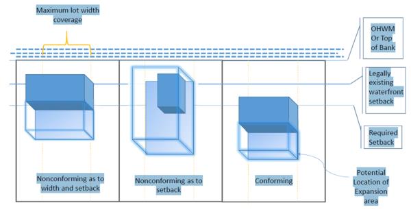
(Ord. 1-2016 §§ 14, 84(G))
18.50.100 Archaeological and historic resources.
A. When an application for a development permit is received for an area known to be archaeologically significant, the applicant must submit a cultural resources report with the permit application. The department will forward this report to the Native American nations and Washington State Department of Archaeology and Historic Preservation (DAHP) with a request for comments within 10 working days. The County will not take final action on the application until the comment period has ended. If the application is approved by the County, conditions may be attached reflecting the recommendations of the archaeologist regarding preservation or protection of the site.
B. All development permits will contain a provision advising the permit holder that if during excavation or development of the site an area of potential archaeological significance is uncovered, all activity in the immediate vicinity of the find must be halted immediately, and the director, the DAHP and affected Native American nations must be notified at once.
C. Additional regulations to protect archaeological and historic resources are established in SJCC 18.60.210.
D. Structural shoreline stabilization measures may be allowed where wind, rain, storms, or waves expose verified archaeological and historic resources. The permit application for the stabilization measures must be submitted by the affected Native American tribe(s). Prior to issuing the permit, the authenticity of the cultural and historic resources must be verified by the DAHP in coordination with all affected Native American nations. (Ord. 8-2020 § 8; Ord. 1-2016 § 15)
18.50.110 Clearing, grading, fill, excavation and vegetation management.
A. All clearing, grading, fill and excavation must comply with SJCC 18.50.130, 18.60.060 and 18.60.070.
B. All shorelines must be protected from degradation caused by the modification of the land surface within the shoreline area or the adjacent lands. Land clearing, grading, fill and alteration of natural drainage features and land forms must be designed to prevent adverse impacts to adjacent properties or shoreline ecological functions. Unless specifically allowed by this chapter, vegetation clearing and land surface grading and filling are prohibited.
C. The following requirements apply to land clearing, grading, filling, or alteration of natural drainage and topography for residential construction:
1. Land clearing, grading, filling, or alteration of natural drainage and topography shall be limited to the area necessary for driveways, buildings, and view and solar access corridors. Cleared surfaces not to be covered with gravel or impervious surfaces shall be replanted promptly with native or compatible plants (i.e., groundcovers or other plant materials adapted to site conditions which will protect against soil erosion). This applies to individual construction and shoreline subdivisions. Existing vegetation shall be used to visually buffer structures as viewed from the shoreline, public roads, and adjoining properties. All applications for new construction and subdivisions shall identify trees that are proposed to be removed. If trees are to be removed beyond those required to construct a single-family residence, then a tree removal plan shall also be submitted. The plan shall:
a. Identify the proposed building areas, driveways, and view and solar access corridors; and
b. Demonstrate how existing natural screening will be retained while providing for construction, views, and sunlight.
D. All building permit applications for new nonresidential construction, uses, structures or activities must show all trees on the site plan and identify any trees proposed to be removed. If trees are to be removed at other times, a tree removal plan must be submitted to the department for review and approval. Site and tree removal plans must:
1. Identify the proposed and existing building areas, driveways, and view and solar access corridors;
2. Demonstrate how natural screening will be retained while providing for construction, views, and sunlight;
3. Demonstrate how the tree protection requirements in critical area buffers and tree protection zones in SJCC 18.50.130 will be met; and
4. Include a report by a certified arborist for hazard tree removal.
E. Fill in flood hazard areas identified on the Flood Insurance Rate Maps (FIRMs) is not allowed unless the director finds that no feasible alternative exists. Land clearing, grading, filling, and altering of wetlands, natural drainage features and topography are limited to the minimum area necessary for driveways, buildings, and views, and must conform with critical area requirements and SMP setbacks. It is the property owner’s responsibility to obtain required state and federal authorizations for work in wetlands, streams or shoreline waters. Fill and excavation within wetlands or waterward of the OHWM will only be allowed for the following purposes:
1. Interagency environmental restoration or cleanup projects to dispose of contaminated sediment;
2. Disposal of dredged material evaluated and conducted in accordance with the Dredged Material Management Program of the WDNR or the Dredged Material Management Office of the ACOE (see SJCC 18.50.440);
3. Expansion or alteration of transportation facilities of statewide significance currently located on the shoreline where alternatives to fill are infeasible;
4. Ecological restoration or enhancement projects, such as beach nourishment, habitat creation, culvert upgrades to improve fish and flow passage, or bank restoration when consistent with a restoration plan approved as part of this SMP; and
5. Protection of archaeological, cultural or historic resources when fill is the most feasible method to avoid continued degradation, disturbance or erosion of a site. Such fill must be coordinated with any affected Native American nations and comply with applicable provisions of SJCC 18.60.210.
F. When clearing, grading, filling or excavating will cause adverse impacts to ecological functions, a mitigation plan must be prepared and implemented in accordance with SJCC 18.50.140, 18.50.150 and 18.50.160.
G. Fill landward of the OHWM is allowed provided it:
1. Is conducted outside required buffers and setbacks as part of an approved shoreline use;
2. Is the minimum needed to implement the approved shoreline use;
3. Does not significantly change the topography of the landscape in a manner that affects the runoff characteristics; and
4. Does not increase the risk of slope failure.
H. All fill and excavation waterward of the OHWM not associated with ecological restoration require a shoreline conditional use permit.
I. All debris and other waste material resulting from construction are to be managed or disposed of in a fashion that prevents entry into any water body or wetland.
J. Clearing, grading, filling or excavating is not allowed where shoreline stabilization will be necessary to protect materials placed or removed, except when they are part of an approved plan to protect cultural resources including archaeological artifacts.
K. Fill, beach nourishment and excavation are to be designed to blend physically and visually with the topography existing on the date of application whenever possible, so as not to interfere with water-dependent uses, lawful access and enjoyment of scenery.
L. Fill is not allowed for the sole purpose of expanding the developable area of a lot.
M. Applications for substantial development permits proposing fill must include the following information:
1. Source of fill material;
2. Physical characteristics of fill material;
3. Proposed methods of placement and compaction;
4. Proposed surfacing material;
5. Proposed quantity of fill;
6. Proposed method(s) of erosion control; and
7. Proposed use of filled area.
N. On natural (as opposed to manmade, privately owned) lakes, retaining walls are not to be used as erosion control devices on allowed fill.
O. Regulations by Designation.
1. Conservancy. Fill is prohibited within this designation.
2. Aquatic. Fill may be allowed in this designation subject to a conditional use permit.
3. Fill is prohibited within the Eastsound subarea. (Ord. 11-2017 § 7; Ord. 1-2016 § 16)
18.50.120 General environmental protection.
A. Land uses and developments that include vegetation removal, fill, excavation or grading on County shorelines must be designed, located, sized, constructed and maintained to result in no net loss of shoreline ecological functions.
B. Land use and development project proposals that do not meet the critical area requirements for no net loss in SJCC 18.50.130 must include a mitigation sequence analysis that considers avoiding actions, minimizing the scale and scope of the project and possible mitigation actions. Where a project may cause or increase the intensity of unavoidable adverse impacts on shoreline ecological functions, mitigation to offset the impacts is required and must be consistent with the mitigation sequence and mitigation planning process in SJCC 18.50.140, 18.50.150 and 18.50.160.
Where land use or development projects meet or exceed the protections required by the critical area regulations in SJCC 18.50.130, mitigation is not required. All new uses, developments and ancillary activities that do not comply with SJCC 18.50.130 require mitigation of adverse impacts consistent with the provisions of SJCC 18.50.140, 18.50.150 and 18.50.160.
C. All shoreline uses, structures, and activities are to be located, designed, constructed, and managed in a manner that is aesthetically compatible with the affected area.
D. On all nonbedrock shorelines all new structures are subject to coastal geologic buffers consistent with SJCC 18.50.130.
In addition to the requirements of SJCC 18.35.070 and 18.35.130, Figure 3.1, the required technical report must:
1. Evaluate the potential impacts on water circulation, sand and gravel movement, erosion and accretion;
2. Evaluate the potential impacts of sea level rise over the life of the structure (75 years); and
3. Demonstrate that the proposed buffer will be sufficient to avoid the need for new protective structural shoreline stabilization and flood protection measures for the life of the structure (75 years).
E. Herbicides and pesticides shall not be applied to, or allowed to directly enter, water bodies or wetlands unless approved for such use by the appropriate agencies.
F. The cultivation of genetically modified crops, livestock and other organisms is prohibited in the shoreline jurisdiction under Chapter 8.26 SJCC. (Ord. 11-2017 § 8; Ord. 1-2016 § 17)
18.50.130 Critical areas.
A. The San Juan County critical area regulations codified in Chapter 18.35 SJCC are incorporated into this SMP except as noted in subsection (B) of this section. These regulations were adopted by the County in Ordinance 52-2008 on November 18, 2008; Ordinances 26-, 27-, 28-, and 29-2012, on December 3, 2012; Ordinance 2-2014 on March 5, 2014; Ordinance 16-2014 on November 4, 2014; and Ordinance 1-2015 on January 27, 2015.
B. Provisions of the critical area regulations that are not consistent with Chapter 90.58 RCW (the Shoreline Management Act) and its supporting WACs do not apply in the shoreline jurisdiction including the:
1. Critical area applicability provisions do not apply in the shoreline jurisdiction. Specifically SJCC 18.35.025 does not apply.
2. Critical area reasonable use exceptions do not apply in the shoreline jurisdiction. Specifically SJCC 18.35.035 does not apply.
3. Critical area mitigation requirements do not apply in the shoreline jurisdiction. Specifically SJCC 18.35.040 does not apply.
4. Critical area existing legally established structures, uses and activities do not apply in the shoreline jurisdiction. Specifically SJCC 18.35.045 does not apply.
5. Critical area nonconforming structures, uses and activities do not apply in the shoreline jurisdiction. Specifically, SJCC 18.35.050 does not apply.
6. Critical area provisions for reduced water quality buffers and tree protection zones when views of the water are blocked by existing houses on adjoining waterfront parcels do not apply in shoreline jurisdiction. Specifically SJCC 18.35.130(F) does not apply.
7. Critical area standards and requirements for shoreline modifications do not apply in the shoreline jurisdiction. Specifically SJCC 18.35.130(G) does not apply. Critical area standards and requirements for aquaculture activities and uses allowed in and over aquatic fish and wildlife habitat conservation areas do not apply in shoreline jurisdiction. Specifically, items (f) and (g) in SJCC Table 18.35.130-3 do not apply. (Ord. 11-2017 § 9; Ord. 1-2016 § 18)
18.50.140 Mitigation of adverse impacts to shoreline ecological functions.
A. Shoreline development, land uses, structures and activities must meet the no net loss requirement of WAC 173-26-186(8)(b). If project proposals do not comply with the critical area protections in SJCC 18.50.130, applicants must submit a mitigation sequence analysis to the department.
B. Mitigation measures must be applied in the following sequence. The applicant must demonstrate that each mitigation action is not feasible or applicable before proceeding to the next option or action:
1. Avoiding the impact altogether by not taking a certain action or parts of an action;
2. Minimizing impacts by limiting the degree or magnitude of the action and its implementation by using appropriate technology or by taking affirmative steps to avoid or reduce impacts;
3. Rectifying the impact by repairing, rehabilitating, or restoring the affected environment;
4. Reducing or eliminating the impact over time by preservation and maintenance operations;
5. Compensating for the impact by replacing or providing substitute resources or environments; and monitoring the impact and compensation projects, and taking appropriate corrective measures; and
6. Monitoring the impact and the compensation projects and taking appropriate corrective measures.
C. When feasible, adverse impacts are to be mitigated on site. Preferential consideration shall be given to measures that replace impacts to functions directly and in the immediate vicinity of the impact. The director may authorize off-site compensatory mitigation within the watershed that addresses limiting factors or identified critical needs for shoreline resource conservation measures identified in the San Juan County Water Resource Inventory Area (WRIA) 2 Plan, the San Juan County Shoreline Restoration Plan, or other restoration or mitigation plans adopted by a public agency. If off-site mitigation is proposed, the mitigation site must be located within the stormwater watershed of the development site.
The County’s stormwater watersheds on San Juan, Orcas, and Lopez islands are identified on a map used as the basis of the San Juan County Stormwater Basin Planning report dated June 26, 2014. For islands without identified stormwater basins, a qualified professional shall determine the watershed basin.
D. Modifications to wetlands or buffers may be exempt from the requirement to avoid impacts when the wetland is below minimum size thresholds listed in SJCC 18.35.095, provided impacts are fully mitigated according to the remaining mitigation sequence in subsection (B) of this section. (Ord. 21-2018 § 3; Ord. 11-2017 § 10; Ord. 1-2016 § 19)
18.50.150 Mitigation plans.
A. If a mitigation sequence analysis demonstrates that adverse impacts on shoreline ecological functions are unavoidable, mitigation, monitoring and adaptive management plans to offset the adverse impacts must be developed by a qualified professional.
B. Where the proposal will have an adverse impact on wetland ecological functions, mitigation plans, including associated wetland replacement ratios, must be consistent with the guidance provided in Wetland Mitigation in Washington State – Part 1: Agency Policies and Guidance, Ecology Publication No. 06-06-011a (as amended); and Wetland Mitigation in Washington State – Part 2, Publication No. 06-06-011b (as amended). As an alternative, mitigation actions may follow the procedures described in Ecology Publication No. 10-06-011, Calculating Credits and Debits for Compensatory Mitigation in Wetlands of Western Washington (as amended) or another mitigation approach or publication approved by WDOE.
C. Mitigation options may include the use of certified mitigation banks and approved in lieu fee mitigation sites when they are identified and approved by the County council.
D. Removal of shoreline modifications constructed in violation of this code cannot be used to mitigate new adverse impacts to shoreline ecological functions and critical area functions if those modifications were made by the owner of the property, or if they are located on the property that is the subject of the application.
E. Mitigation, monitoring, and adaptive management plans are reviewed and approved by the decision-maker for the underlying permit or approval (director or hearing examiner, depending on type of permit or approval).
F. Mitigation plans must address the scale and scope of the project, and document compliance with the mitigation approval criteria. Mitigation plans must include at least the following information, as applicable:
1. For both the area proposed for development or vegetation removal, and the proposed mitigation site, the applicable items listed in SJCC 18.80.020(C);
2. Photographs of both the development and mitigation sites;
3. The field located OHWM;
4. A mitigation sequencing analysis;
5. Any related project documents such as applications to other agencies or environmental documents prepared pursuant to the SEPA;
6. For both the area proposed for development or vegetation removal, and the proposed mitigation site, applicable critical area reports, tree removal plans, and BAS documents supporting the proposal;
7. For both the area proposed for development or vegetation removal, and the proposed mitigation site, copies of any proposed or approved stormwater and erosion control plan required by Chapter 18.60 SJCC;
8. A narrative describing anticipated unavoidable adverse impacts to critical area functions, the mitigation proposal (including the goals of the proposal, performance standards that will be used to gauge the effectiveness of the proposal, construction methods, and the sequence and timing of actions), and explaining how the proposal meets the plan approval criteria. Assessment of adverse impacts to critical area functions and of the effectiveness of proposed mitigation must be based on the BAS;
9. For off-site mitigation actions, an explanation of why on-site mitigation was not feasible, along with the site selection criteria employed, including a watershed approach for the selection of mitigation sites;
10. If grading, fill or excavation is proposed, pre- and post-construction contour plans are required at a scale suitable for the site;
11. A planting plan (if planting is proposed) identifying plant species, quantities, sizes, locations, spacing, and density, along with proposed measures to protect and maintain the plants until they are established;
12. Any other drawings necessary to illustrate the proposal;
13. A description of the report author’s education and experience relevant to designing and implementing the proposed actions;
14. A monitoring and adaptive management plan appropriate for the scale and scope of the project as determined by a qualified professional and approved by the decision-maker. The monitoring and adaptive management plan must include:
a. A description of measurable indicator data to be collected. The description will demonstrate the validity of the collected data to assess the effectiveness of the project;
b. A monitoring schedule. Data collection must occur at least once each calendar year. The minimum monitoring schedule is five years, provided the schedule can be reduced after three years if the director makes a written determination that the mitigation plan is successful, functioning as designed and the established performance standards have been met. If the plan is unsuccessful, the director may extend the monitoring requirements; and
c. A requirement for a report submitted to the department by November 1st of each calendar year explaining corrective actions that will be taken to address unforeseen adverse impacts;
15. A cost estimate prepared by a qualified professional for implementing the mitigation plan and monitoring the site;
16. Unless exempt under RCW 36.32.590, a financial guarantee and associated agreement are required pursuant to SJCC 18.80.200;
17. The financial guarantee and the associated agreement must meet the requirements of SJCC 18.80.200. For mitigation of adverse impacts to wetlands and fish and wildlife habitat conservation areas, it must initially be established to cover the time period until the project is anticipated to be completed and functional as determined by the qualified professional and approved by the decision-maker; and
18. A statement, signed by the property owner, agreeing to the periodic inspections established in the monitoring plan. The purpose of inspections is to determine compliance with approved plans. Inspections can be performed by either a qualified professional hired by the property owner, or a County representative. If a County representative conducts the inspection(s), they will be by appointment or following advance written notice.
G. If the County’s review of a mitigation plan requires a referral to independent qualified professionals, the review will be conducted at the applicant’s expense. If review by a third party is necessary because of the complexity of the plans or apparent errors, the department may require advance payment of fees for this review based on the estimated review time. As an alternative to third party review, the applicant and the director may jointly select the qualified professional who will complete the plans. (Ord. 11-2017 § 11; Ord. 1-2016 § 20)
18.50.160 Mitigation plan approval criteria.
A. Approval of mitigation plans will be based on conformance with the following criteria:
1. The applications and projects are consistent with the mitigation sequence in SJCC 18.50.140(B); and
2. The mitigation has been developed consistent with the published mitigation standards for the applicable critical area, including a description of monitoring methods and frequency and measurable performance standards.
B. The County will record a copy of the approved mitigation plan and mitigation monitoring agreement.
C. If the goals, objectives and performance standards of the mitigation plan are not met, the decision-maker may require additional actions and may extend the monitoring period, financial guarantee and associated agreement. (Ord. 1-2016 § 21)
18.50.170 Flood hazard reduction.
A. Applicability. This section regulates the construction of structural flood hazard reduction measures such as:
1. Dikes;
2. Levees;
3. Revetments;
4. Flood walls; and
5. Channel realignments.
Small scale structural flood hazard reduction measures such as raising a building above the base flood elevation, or the creation of underfloor spaces meeting the requirements of FEMA/FIA Technical Bulletin (TB) 11-1 (as amended), are not subject to the regulations in this section.
B. General Regulations.
1. Where feasible, nonstructural flood hazard reduction measures such as setbacks, wetlands restoration, stormwater management programs and structural relocation are preferred over structural solutions.
2. New structural flood control works are only allowed in the shoreline jurisdiction if it is demonstrated by analyses prepared by qualified professionals that:
a. They are necessary to protect existing development or to mitigate or resolve existing stormwater problems;
b. Impacts to critical areas can be successfully mitigated to result in no net loss of shoreline ecological functions;
c. Appropriate vegetation conservation actions will be undertaken; and
d. Nonstructural flood hazard reduction measures are infeasible.
3. All development or uses in areas of special flood hazard designated by the County’s FIRMs and Flood Hazard Boundary Maps (FHBMs) are subject to the provisions of Chapter 15.12 SJCC and SJCC 18.35.075.
4. New structural flood hazard reduction measures must be placed landward of associated wetlands and wetland habitat buffers, except for measures that increase shoreline ecological functions, such as wetland restoration.
5. The removal of substrate for flood management purposes is prohibited.
6. The applicant must provide the following information:
a. Flood hazard area characteristics adjacent to the project area;
b. Physical, geological and soil characteristics of the area;
c. An analysis of alternative flood protection measures, both structural and nonstructural;
d. Shoreline stabilization measures and flood protection works within the area existing at the time of application;
e. Predicted impact upon area shore and hydraulic processes, adjacent properties, and shoreline and water uses; and
f. Biological resources and predicted impact to fish, vegetation and animal habitat associated with shoreline ecological systems. (Ord. 11-2017 § 12; Ord. 1-2016 § 22)
18.50.180 Public access.
A. Except as provided in subsections (B) and (C) of this section, a development, use, structure or activity that requires a shoreline substantial development or conditional use permit shall provide public access or community access consistent with RCW 90.58.020 as mitigation, if one of the following applies:
1. Where it will create increased demand for public access to the shoreline;
2. Where it will interfere with a public access way existing on the date of application;
3. Where developments, uses, structures or activities that are not a priority shoreline use under the SMA will locate on the shoreline of the state;
4. Where it will interfere with a public use of lands or waters subject to the Public Trust Doctrine;
5. If land is proposed to be divided to create five or more lots; or
6. If it is a project proposed by a public entity. The project application shall describe the impacts of the proposal on public access, the required public access conditions, and how the conditions address the impact.
B. An applicant need not provide public access if one or more of the following applies:
1. Land is divided creating no more than four lots;
2. Unavoidable health or safety hazards to the public exist that cannot be prevented by practical means;
3. Inherent security requirements of the use cannot be satisfied through the application of alternative design features or other solutions;
4. The cost of providing the access, easement or alternative amenity is unreasonably disproportionate to the long-term cost of the proposed development;
5. Environmental harm will result from the public access that cannot be mitigated;
6. Significant undue and unavoidable conflict between any access provision or adjacent uses would occur and cannot be mitigated;
7. The County conducted a Countywide public access planning process that provides more effective public access than the single project access requirements; or
8. Other legal limitations apply.
C. In order to meet any one of the conditions in subsections (B)(2) through (8) of this section, the applicant must demonstrate and the County must determine in written findings that all feasible alternatives have been exhausted such as:
1. Regulating access by maintaining a gate, limiting hours of use, or other means;
2. Separating uses and activities (e.g., with fencing, terracing, one-way glazing, landscaping, etc.); and
3. Developing provisions for access at a site geographically separated from the proposal such as a road end, vista or trail system.
D. Development, structures, uses and activities shall be designed, constructed, operated and maintained to avoid blocking, reducing or interfering with the public’s physical accesses to the water and shorelines.
E. Public access provided by shoreline road ends, public utilities, and rights-of-way may not be diminished. Existing road ends and other shoreline access points are allowed in all shoreline designations.
F. Where feasible, public access sites shall be connected directly to the nearest public road and shall include provisions for handicapped and physically impaired persons.
G. Required public access sites shall be fully developed and available for public use at the time of the occupancy of the permitted development, use, structure or activity. Where applicable, public access sites shall be fully developed prior to final approval of a land division.
H. Public access easements, common areas and related conditions shall be recorded on the deed of title or on the face of a land division plat.
I. The standard state-approved logo or other approved signs that indicate the public’s right of access and hours of access shall be constructed, installed and maintained by the applicant in conspicuous locations at public access sites. Signs may control or restrict public access as a condition of permit approval.
J. Future actions by the property owner may not diminish the usefulness or value of the required public access.
K. Compliance with the public access plan for Eastsound consistent with the Eastsound Subarea Plan adopted as part of the SMP for the Village Commercial waterfront is required. (Ord. 1-2016 § 23)
18.50.190 Signs.
In addition to the standards in Chapter 18.40 SJCC, the following requirements apply:
A. Regulations.
1. Plans and designs for nonexempt signs must be submitted for review at the time of shoreline permit application.
2. All signs must be located and designed to minimize interference with vistas, viewpoints, and visual access to the shoreline. Signs shall not face or be directed toward the water except for cable crossing signs, ferry signs, and signs located outside of hamlets, villages, UGAs and activity centers. Within hamlets, villages, UGAs and activity centers, directional and identification signs of water-dependent and water-related businesses may face the water.
3. Except for over-water signs or signs on floats or pilings directly related to the operations of a water-dependent use, over-water signs are prohibited. The highest point of allowed over-water signs may not exceed 12 feet above the OHWM.
4. Light sources for externally lit signs shall be shielded or recessed. Light sources must be consistent with the standards in SJCC 18.50.200.
5. Signs related to specific on-site uses or activities must not exceed the maximum size limits specified in Chapter 18.40 SJCC. Where allowed, the following standards apply to on-site freestanding signs as measured from the highest point to average grade:
a. On-site freestanding signs on public property shall not exceed nine feet in height; or
b. On-site freestanding signs on private property shall not exceed six feet in height; or
c. Within Eastsound, on-site freestanding signs on private property shall not exceed five feet in height.
6. Where feasible, signs must be mounted flush against a structure except as allowed by subsection (B)(2) of this section. Signs mounted flush to a structure must not extend above the highest point of the structure on which they are attached. Signs mounted at right angles to the side of a structure are measured from the top of the sign and may be two and one-half square feet per face.
7. The following types of signs are allowed in all shoreline designations:
a. Water navigational, cable crossing, waterway and roadway safety, and directional signs;
b. On-site public information signs directly relating to an allowed shoreline use or activity;
c. Off-premises freestanding signs for community identification, information, or directional purposes, if consistent with this section and Chapter 18.40 SJCC;
d. National, state and institutional flags or temporary decorations customary for holidays and similar events of a public nature;
e. Temporary directional signs to public or quasi-public events if removed within 72 hours following the event; and
f. No-trespassing signs and no-hunting signs that do not exceed two square feet.
8. The following types of signs are prohibited in all shoreline designations:
a. Signs that significantly impair visual access to the shoreline;
b. Off-premises outdoor “A-frame” signs;
c. Spinners, streamers, pennants, flashing lights, internally lit signs, and other animated signs except as required by local, state or federal law for navigation and safety; and
d. Signs placed on trees or other natural features.
B. Additional Regulations by Designation.
1. Rural, Rural Residential, and Ports, Marinas and Marine Transportation. Freestanding signs in these designations shall not be more than six feet in height, measured from the top of the sign to average grade.
2. Conservancy. Signs are allowed only if they are mounted flush to the wall of a structure or are freestanding signs used for federal, state, or County purposes.
3. Natural and Aquatic. Signs are prohibited in these designations except for traffic signs, official warning signs, signs identifying public facilities, and other signs required by law; provided, other signs are allowed in the aquatic designation if they are mounted flush to the side of a structure and only if they could not as effectively be located on land. (Ord. 1-2016 § 24)
18.50.200 Lighting.
A. Except as necessary to meet federal, state, and local safety or navigation standards, all external lighting fixtures must be shielded, recessed and dark sky rated. Light must be directed downward and away from:
1. Wetlands;
2. Wetland buffers;
3. Fish and wildlife habitat conservation areas and associated buffers;
4. Adjoining properties; and
5. Public roads or rights-of-way.
B. All glare and reflections from external light sources must be contained within lot boundaries.
C. Flashing or blinking lights are prohibited. (Ord. 1-2016 § 25)
Article III. Regulations for Specific Developments, Uses, Structures and Activities
18.50.210 General regulations.
The SMP regulations directly support the adopted goals and policies for each shoreline designation and development, use, activity or structure. They reflect and are intended to preserve the special character of each designation. Each designation contains general regulations for allowed uses. Additional regulations including shoreline permitting requirements for developments, uses, structures and activities by designation are addressed in Table 18.50.600.
A. Shoreline uses not specifically identified in this SMP and for which regulations have not been developed will be evaluated on a case-by-case basis. They may be allowed subject to a conditional use permit. Such proposals must be consistent with the policies of the SMA, and the goals and general policies of this SMP including the character and management policies of the shoreline designation in which they are to be located.
B. In addition to the general regulations of Article II, this article identifies:
1. Specific uses;
2. General development standards for named uses; and
3. Development standards that apply to the different shoreline designations where appropriate.
C. Shoreline development, uses, structures and activities shall not result in a net loss of shoreline ecological functions or adversely impact other shoreline uses, resources and activities such as navigation, recreation and public access. Where critical area regulations are not met, adverse impacts to shoreline ecological functions must be mitigated consistent with SJCC 18.50.140, 18.50.150 and 18.50.160. (Ord. 1-2016 § 26)
18.50.220 Agriculture.
A. General Regulations.
1. In accordance with SJCC 18.50.130, buffers of permanent vegetation or other suitable soil erosion controls shall be established and maintained between tilled or grazed areas and associated water bodies and wetlands. The type and extent of such vegetation and other controls shall be of a width or character sufficient to capture sediments and other compounds.
2. Confined animal feeding operations, retention or storage ponds for feedlot wastes, and stockpiles of manure solids shall be located to prevent water contamination consistent with guidelines prepared by the U.S. Environmental Protection Agency and the requirements of state and local agencies.
3. Commercial feedlots are prohibited.
4. New agricultural activities in the shoreline jurisdiction shall be located, designed, constructed and managed in a manner that will result in no net loss of shoreline ecological functions.
B. Regulations by Designation.
1. Natural. Agricultural activities may be allowed in this designation subject to a conditional use permit; provided, that the resource to be protected by the natural designation will not be degraded. (Ord. 11-2017 § 13; Ord. 1-2016 § 27)
18.50.230 Aquaculture.
A. General Regulations. Except as restricted in subsection (B) of this section, the following regulations apply to all aquaculture:
1. Shorelines within the County that are located seaward of the line of extreme low tide have been designated “shorelines of statewide significance.”
2. Structures or facilities that would have a significant adverse impact on shoreline ecological functions are prohibited.
3. Private, noncommercial aquaculture activities that do not include development are not subject to this section.
4. No aquatic organism shall be introduced into County waters without prior written approval of the WDFW, WDNR, the County’s noxious weed control board, or the appropriate regulatory agency for the specific organism proposed for introduction. Such approvals shall be submitted in writing to the department prior to the introduction of the organism or the granting of the permit decision, whichever comes first. Introduction, for purposes of this section, means the placement of any aquatic organism in any area within the waters of the County regardless of whether it is a native or resident organism within the County and regardless of whether it is being transferred from within or beyond County waters.
5. Unless required by the shoreline permit issued by the department, after a permit is issued for a specific organism, the repeated introduction of an approved organism in the same location does not require subsequent approval by the department.
6. Aquaculture shall comply with all applicable noise, light, glare, air pollution, and water quality standards including those in Chapter 18.60 SJCC. Aquaculture operations shall minimize adverse impacts to nearby residents. Some impacts from odor, noise and light may be unavoidable and will not be considered sufficient cause to deny a project application.
7. Aquaculture structures and equipment, except navigation aids, shall be designed, operated, and maintained to blend into their surroundings through the use of appropriate colors and materials. They shall not adversely impact the aesthetic qualities of the surrounding area.
8. The department may require commercial aquaculture applicants to provide a financial guarantee in an amount commensurate with the risk of injury or damage to any person, property, or shoreline ecological functions as a result of the project. Financial guarantees shall not duplicate the requirements of other agencies.
9. All aquaculture structures and facilities shall be marked in accordance with U.S. Coast Guard requirements.
10. Aquaculture structures and equipment shall be properly constructed and maintained. Abandoned or unsafe structures and equipment shall be removed or repaired promptly by the owner. The department requires a financial guarantee in an amount commensurate with the cost of their removal or repair if any structure might constitute a potential hazard to the public in the future. The department may abate an abandoned or unsafe structure in accordance with Chapter 7.48 RCW and may take action necessary to enforce the financial guarantee of the applicant. Evidence of the County’s financial guarantee shall be considered independently of the requirements of other agencies.
11. Applications shall include adequate information to demonstrate that the proposed operation complies with this SMP. Applications shall include at least the following information, when applicable:
a. Species to be reared;
b. Aquaculture method(s) including the identification of all pesticides, herbicides, antibiotics, vaccines, growth stimulants, anti-fouling agents, feed or other chemicals the applicant anticipates using;
c. Number of employees;
d. Harvest and processing location, method, and timing;
e. Location and plans for any shoreside activities, including loading and unloading of the product, processing, and any use of freshwater supplies;
f. Methods of waste disposal and predator control;
g. An environmental assessment that includes the best available information on water quality, tidal variations, prevailing storm wind conditions, current flows, flushing rates, aquatic and benthic organisms, and probable impacts on water quality, macroalgae, biota, currents, littoral drift, and any shoreline or water uses existing on the date of application. Further baseline studies may be required depending upon the adequacy of available information, conditions existing on the date of the application, the nature of the proposal, and probable adverse environmental impacts. Applicants may submit documents previously submitted to other agencies. Baseline monitoring shall be at the applicant’s expense unless otherwise provided for;
h. For floating aquaculture facilities, the department may require a visual impact analysis consisting of information comparable to that found in the WDOE’s “Aquacultural Siting Study” of 1986; and
i. Other pertinent information deemed necessary by the director.
12. No pesticides, herbicides, antibiotics, vaccines, growth stimulants, anti-fouling agents, feed, chemicals or other such materials shall be used until approval is obtained from all appropriate state and federal agencies, including the U.S. Food and Drug Administration, the Washington Department of Agriculture, Washington Department of Health (WDOH), WDOE, and WDFW, and proof of such approvals has been submitted to the department.
13. Legally established aquaculture enterprises including authorized experimental projects shall be protected from incompatible uses that are proposed to locate nearby. Demonstration of a probability that such use would result in damage to or destruction of an aquaculture enterprise is grounds for the denial of that use.
14. Operational monitoring of commercial aquaculture facilities may be required to the extent necessary to determine, ensure, or confirm compliance with predicted or required performance. Monitoring shall be consistent with local, state and federal requirements. Monitoring requirements shall be established as a condition of the permit and shall be conducted at the applicant’s or operator’s expense.
15. No processing of any commercial aquaculture product, except for the sorting or culling of the cultured organism and the washing or removal of surface materials or organisms, shall occur in or over the water after harvest, unless specifically approved by permit. All other processing facilities shall be located on land and are also governed by the commercial development regulations.
16. Aquaculture waste must be disposed of in a manner that complies with all applicable waste disposal standards. No garbage, waste, or debris is allowed to accumulate at an aquaculture operation.
17. Projects involving substantial substrate modification shall be located 1,500 feet or more from areas identified in National Wildlife Refuge lands, marine protected areas and state or County parks. Lesser distances may be authorized by permit if the applicant demonstrates that the wildlife resource will be protected and the exception is supported by the reviewing resource agencies. Greater distances also may be required if recommended by the reviewing resource agencies.
18. Aquaculture uses and facilities may intrude into or over critical saltwater habitats where the public’s need for such an action is clearly demonstrated and the proposal is consistent with the protection of the public trust; the project is consistent with the state’s interest in resource protection and species recovery; an alternative alignment or location is not feasible; and potential adverse impacts are identified and mitigated to result in no net loss of shoreline ecological functions consistent with the requirements of SJCC 18.50.140.
19. Predator control shall not involve the intentional killing or abusive harassment of birds or mammals. Approved controls include but are not limited to double netting for seals, overhead netting for birds, and three-foot-high fencing or netting for otters. The use of other nonlethal and nonabusive predator control measures requires the submittal of written approval from the National Marine Fisheries Service or U.S. Fish and Wildlife Service.
20. When feasible , the cleaning of nets and other apparatus shall be accomplished by air drying, spray washing, or hand washing.
21. For commercial aquaculture projects using over-water structures, the storage of necessary tools and apparatus seaward of the OHWM is limited to containers not more than three feet in height as measured from the surface of the floating aquaculture facility or dock. However, in locations where the visual impact of the proposed commercial aquaculture structures will be minimal, storage containers of greater height may be authorized by the decision-maker. In such cases, the burden of proof is on the applicant.
22. Materials that are not necessary for the immediate and regular operation of the facility shall not be stored seaward of the OHWM.
23. Mechanical clam harvesting or other actions that involve substrate modification through dredging, trenching or digging are prohibited in all eelgrass beds.
24. Commercial finfish net pens are prohibited.
25. Commercial aquaculture proposals that include floating aquaculture facilities shall not be located closer than one nautical mile to any other commercial floating aquaculture facility. A lesser distance may be authorized by the decision-maker if the applicant can demonstrate that the ecological and aesthetic protection requirements of this SMP will be met. If a lesser distance is requested, the applicant must demonstrate that the cumulative impacts of the existing and proposed operations will not be contrary to the regulations of this SMP.
26. Experimental and noncommercial aquaculture developments shall not exceed five acres in area (except anchorage for floating aquaculture systems and restoration projects) and five years in duration. The decision-maker may, however, issue a new permit to continue an experimental project as many times as is necessary and appropriate.
27. When it is necessary to preserve the integrity of collectible research data, commercial aquaculture project applications will be reviewed for potential adverse impacts on experimental and noncommercial aquaculture developments existing at the time of application. If there is evidence that an additional project would likely jeopardize a noncommercial or experimental aquaculture project, the commercial project will not be allowed within the same bay, harbor, or cove, or within one mile of such a development if the water body is larger than one square mile in area, until after the experimental project is granted nonexperimental status or terminated.
28. If it is determined that proposed new commercial aquaculture projects are likely to affect water quality and pose potential adverse impacts to an allowed and currently established aquaculture operation, a separate administrative review will be completed prior to issuing any project permit(s). The director may request research or an analysis to be prepared by appropriate experts to assist the department in determining marine water quality impacts. No project permit will be granted for a new project if it is likely to damage or destroy the established aquaculture operation.
29. A conditional use permit is required for commercial geoduck aquaculture. Subsequent cycles of planting and harvesting do not require a new conditional use permit. A single conditional use permit may be submitted for multiple sites within an inlet, bay or other defined feature, provided the sites are all under the control of the same applicant.
30. Geoduck operations shall be located where sediments, topography, and land and water access can accommodate operations without adversely impacting shoreline ecological functions.
31. Applications shall identify management practices that will be implemented to address impacts from mooring, parking, noise, lights, litter, and other activities associated with geoduck planting and harvesting operations.
B. Small Scale Shellfish Aquaculture.
1. Small scale shellfish aquaculture and supplemental wildstock seeding that do not adversely impact shoreline ecological functions or aesthetic qualities are allowed in the nearshore waters with a certificate of exemption; provided, that it does not:
a. Intrude into critical saltwater habitats on shorelines of statewide significance unless there is no feasible alternative; and
b. Exceed the shoreline substantial development permit exemption criteria in SJCC 18.50.040(D)(1).
2. Applications for shellfish aquaculture and supplemental wildstock seeding operations shall demonstrate compliance with all state and federal requirements including:
a. Hydraulic project approval or joint aquatic resources permit application from the WDNR;
b. Certification and license from the WDOH; and
c. Shellfish import or shellfish transfer permits from WDFW.
3. A conditional use permit is required if projects conflict with public access, navigation, or adversely impact critical saltwater or freshwater habitats.
4. Applications for certificates of exemption for shellfish aquaculture shall include the information required under subsection (A)(11) of this section, as applicable.
C. Regulations by Designation.
1. Rural Residential. Floating aquaculture facilities may be allowed within 1,500 feet of the OHWM if a visual impact analysis is submitted with the application and approved.
2. Conservancy. Aquaculture activities are allowed in this designation; provided, that natural resources and ecological functions will not be significantly altered; and proposed structures and facilities, both terrestrial and aquatic, will not have a significant adverse impact on the aesthetic qualities of the surrounding area.
3. Natural. Aquaculture activities that do not require structures, facilities or mechanized harvest practices and will result in no net loss of shoreline ecological functions are allowed.
4. Aquatic. Aquaculture activities are allowed in this designation subject to the regulations of the most restrictive abutting shoreline designation. This is determined on a case-by-case basis but is generally the shoreline designation visible within 1,500 feet directly landward of the center of the project site. The regulations of a less restrictive abutting designation may be substituted if the director determines that the public interest would not be compromised. (Ord. 11-2017 § 14; Ord. 1-2016 § 28)
18.50.240 Over-water structures including boating facilities, docks, piers, mooring buoys, and mooring and recreational floats.
A. General Regulations.
1. All over-water structures including boating facilities, docks, piers, mooring buoys, and mooring and recreational floats must be designed to avoid or minimize adverse impacts on marine and aquatic life, and the shore process corridor and its operating systems. Over-water structures are restricted to the minimum size necessary to meet the requirements of the proposed water-dependent use.
2. All over-water structures must be sited and designed to avoid or minimize the need for new and maintenance dredging.
3. The construction of all over-water structures including new, modifications or replacements of existing facilities must meet the applicable design criteria established by the WDFW in WAC 220-660-140 and 220-660-380 relative to materials, siting, disruption of currents, restrictions of tidal prisms, flushing characteristics, and fish passage to the extent that those criteria are consistent with protection of the shore process corridor and its operating systems.
4. At least one safety ladder must be placed on the long side of all new or enlarged main floats at 60-lineal-foot intervals.
5. In general, only one form of moorage or other structure for boat access to the water is allowed on a single lot. A mooring buoy may be allowed to serve single lots, and areas with community use docks, boat ramps and railways. In addition, multiple forms of moorage or structures for boat access to the water may be allowed on a single lot if:
a. Each form of boat access to water serves a public or commercial recreational use, provides public access, is a part of a marina facility, or serves an historic camp or resort; or
b. The location proposed for multiple boat access structures is common area owned by or dedicated by easement to the joint use of the owners of at least 10 shoreline lots.
6. Provided the structure will result in no net loss of shoreline ecological functions, storage structures are allowed on private docks, floats, and piers. Except as provided in SJCC 18.50.280, structures on private docks, floats and piers may be up to three feet in height and 24 square feet in size. The height of buildings providing waiting areas on public docks used for marine transportation may be up to 10 feet in height. Storage buildings on publicly owned over-water structures and marinas are allowed where no feasible alternative exists; provided, that they are no larger than 100 square feet and six feet tall. In all cases, height is measured from the deck surface to the highest point of the structure.
7. Public access and ecological restoration shall be incorporated into publicly financed projects when feasible.
8. Multiple use and expansion of existing over-water structures are preferred over construction of new over-water structures.
9. The order of preference for over-water structures is:
a. Mooring buoys;
b. Existing marinas;
c. Moorage and recreational floats unattached to a pier or floating dock;
d. Boating facilities, docks and ramps serving five or more residences;
e. Joint use or community docks; and
f. Single use docks.
10. Applicants for a shoreline substantial development permit for boating facilities, joint use community docks, private docks, piers, moorage floats and buoys shall demonstrate how the proposed development will be designed, constructed and maintained to minimize adverse impacts. Impacts must be mitigated in accordance with SJCC 18.50.140, 18.50.150 and 18.50.160. At a minimum, potential impacts to the following shall be evaluated:
a. Littoral drift;
b. Sand movement;
c. Water circulation and quality;
d. Fish and wildlife;
e. Navigation;
f. Scenic views; and
g. Public access to the shoreline.
11. Boating facilities that are expected to interfere with the normal erosion-accretion process associated with feeder bluffs are prohibited.
12. Abandoned or unsafe over-water structures shall be removed or repaired promptly by the owner. The department may abate an abandoned or unsafe structure in accordance with Chapter 7.48 RCW.
13. Boats moored at residential boating facilities shall not be used for commercial overnight accommodations.
B. Regulations – General Design and Construction Standards.
1. Nontoxic materials should be used in construction. Use of treated wood containing toxic compounds should be minimized and may only be used where nontoxic materials are deemed infeasible and as allowed by this subsection as follows:
a. Piers, docks and floats shall be constructed of materials that comply with requirements of federal and state regulations.
b. Wood products treated with creosote or pentachlorophenol are prohibited on all new structures or repair projects that come in contact with or could leach into water.
c. No treated wood may be used for the decking on the over-water structures.
d. Treated wood can be used for all structural elements of the over-water structure.
e. Treated wood materials may be utilized on pilings in repair projects for timber structures.
f. All treated wood used in the aquatic environment shall be restricted to those that have met or exceed the industry BMP manual standards found in Best Management Practices for the Use of Treated Wood in Aquatic Environments: USA Version as revised (Western Wood Preservers Institute, Vancouver, WA).
g. Instead of wood, technologies such as EZ Dock or fiber optic lighting may be allowed consistent with the recommendations of state and federal agencies and with the approval of the director.
2. Pilings employed in piers or any other structure shall have a minimum vertical clearance of one foot above the extreme high water of marine shorelines or OHWM of lakes.
3. All floats shall have stops that serve to keep the bottom of the float off tidelands at low tide or off the substrate in lakes.
4. Nonbiodegradable materials used in float, pier, or dock construction shall be shielded and enclosed to prevent disintegration.
5. Overhead wiring and plumbing are prohibited on boating facilities, joint use and private docks, and piers.
6. New or relocated boathouses and covered moorages are prohibited on boating facilities except as allowed for railway systems in SJCC 18.50.290(E).
7. Dock lighting shall shine downward, be of a low wattage, and not exceed a height of three feet above the dock surface. All lighting must be consistent with SJCC 18.50.200.
8. All construction-related debris shall be disposed of properly and legally. Any debris that enters the water shall be removed promptly. Where feasible, floats shall be secured with anchored cables in place of pilings. The cabling must have a mid-line float or similar mechanism to keep the cable from dragging and disturbing the bottom substrates, vegetation and aquatic life.
9. Over-water structures must be marked with reflectors, or otherwise identified to prevent unnecessarily hazardous conditions for water surface users during the day or night. In general, the exterior finish of all structures shall be nonreflective and a color that will visually blend with the background. (Ord. 1-2016 § 29)
18.50.250 Regulations – Boating facilities – General.
A. Boating facilities must not intrude into or over shoreline critical areas unless all of the following criteria are met:
1. The public need for an intrusion is demonstrated and the proposal protects the public trust, as embodied in RCW 90.58.020. To demonstrate how the project protects the public trust, the applicant shall submit a narrative demonstrating that the proposal:
a. Is consistent with the goals and policies and regulations of this SMP;
b. Benefits the public by providing physical or visual access to the shoreline; and
c. Will not have an adverse impact on the navigability of adjacent waters.
2. No feasible alternative exists.
3. The project and any required mitigation will result in no net loss of shoreline ecological functions associated with critical fresh and saltwater habitat.
4. The project is consistent with the state’s interest in resource protection and species recovery.
B. The location, construction, management, and, if necessary, mitigation of adverse impacts of new and expanded boating facilities and associated accessory uses must conform with SJCC 18.50.140, 18.50.150 and 18.50.160 and result in no net loss of shoreline ecological functions.
C. Boating facilities must be the minimum size needed to accommodate the intended use as demonstrated by the demand analysis required in SJCC 18.50.330.
D. Private boating facilities designs may not accommodate more than one boat per residential unit except that one additional space for every 10 residential units served is allowed to accommodate guests.
E. Boating facilities shall be set back at least 10 feet from side property lines. However, a boating facility may be located adjacent to or upon a side property line when mutually agreed to by contract or by covenant with the owners of the adjacent property. A copy of such contract or covenant must be recorded with the County auditor in a format approved by the department to run with each parcel’s titles. (Ord. 1-2016 § 30)
18.50.260 Regulations – Single-family and community joint use docks, and moorage and recreational floats.
A. Joint use community docks are required when docks are proposed as part of new land divisions.
B. Single-family and community joint use docks, moorage and recreational floats serving four or fewer residential units may not intrude into or over shoreline critical areas unless the following criteria are met:
1. Avoidance of impacts to critical salt and freshwater habitats by an alternative alignment or location is not feasible; and
2. The project including required mitigation will result in no net loss of shoreline ecological functions associated with critical fresh and saltwater habitat.
C. Applications for single-family and joint use docks, moorage and recreational floats serving four or fewer residential units may not be approved unless the applicant demonstrates that:
1. The facilities existing at the time of application are not adequate or feasible for use; and
2. Alternative moorage such as mooring buoys, mooring floats, boating facilities and joint use facilities is not adequate or feasible.
D. The size and dimensions of single-family and joint use docks, moorage and recreational floats are provided in Table 18.50.260.
1. The use regulations apply to single-family and community joint use docks, and moorage and recreational floats serving four or fewer residential units.
2. Deviations from the dimensional standards are subject to a shoreline variance.
|
Moorage Element |
Marine and Lake |
|---|---|
|
Number |
No more than one dock, moorage float, or mooring buoy is generally allowed per residential shoreline lot. |
|
Type |
Docks must be fixed pile or combination of fixed pile and floating. |
|
Width |
Single-family and joint use community docks. • Pier: six feet. • Float: eight feet. • Ramp: cannot exceed five feet. |
|
Length |
• Pier and ramp: length as needed to extend float to position where moorage can occur with rise and fall of tides without resulting in either float or vessel grounding or adversely affecting the substrate. • A pier shall not extend offshore farther than 50 feet beyond the extreme low tide contour in marine waters. • Single-family and joint use community docks float length: 30 feet for single use, 60 feet for joint use or deviations may be allowed; applicants must demonstrate the alternative is the minimum necessary to achieve purpose and will minimize expected adverse impacts. |
|
Area |
• Moorage floats unconnected to the land: 250 square feet. • Recreational floats unconnected to the land: 150 square feet. • Single-family dock: 700 square feet including ramp, pier and float. • Joint use dock (two users): 1,400 square feet including ramp, pier and float. • Joint use dock (three to four users): 2,000 square feet including ramp, pier and float. |
|
Height |
The bottom of any piers or the landward edge of any ramp must be the maximum height feasible, but not less than one and one-half feet above the OHWM. The freeboard height on all floats must be at least 10 inches. |
|
Decking |
• Pier: Effective grating is not required if width is four feet or less, otherwise decking and effective grating must cover a minimum of 30 percent of the deck surface. • Single-family float: Decking and effective grating must cover 30 percent of the deck surface if the float is six feet wide or less. Floats greater than six feet wide require decking and effective grating that covers 50 percent of the deck surface. • Joint use floats must have decking and effective grating that covers 50 percent of the float surface. • Ramps must be fully grated. |
|
Orientation |
As close to north/south as feasible to minimize shadows. Also see the WDFW guidelines in WAC 220-660-380 and 220-660-140 as amended. |
|
Safety ladders |
Every 60 lineal feet each long side of main floats. |
|
Boat and watercraft lifts |
Prohibited. |
|
Covered moorage watercraft lift canopies |
Prohibited. |
(Ord. 1-2016 § 31)
18.50.270 Regulations – Commercial/industrial docks and piers.
A. Substantial development permits for new docks or piers serving a commercial or industrial enterprise will not be approved unless the permit application contains information from nearby commercial and industrial enterprises regarding their water access needs and plans. Where more than one enterprise needs and could use a single moorage facility, permits for individual facilities will not be granted.
B. Bulk fuel storage (retail or wholesale) for gasoline, oil, and other petroleum products for any use or purpose is prohibited on piers and docks.
C. Spill containment and clean-up equipment shall be available for prompt response and application at all piers and docks involved in the transfer of gas, petroleum, oil and hazardous products. (Ord. 1-2016 § 32)
18.50.280 Regulations – Marinas.
A. Over-water structures in marinas shall not be wider than eight feet, except that the director may approve larger widths based upon the submittal of documentation consistent with SJCC 18.50.330.
B. Over-water structures in marinas must be no longer than needed to achieve the intended use, as demonstrated by the demand analysis requirement in SJCC 18.50.330.
C. Dredging or filling of wetlands for the sole purpose of constructing a marina is prohibited.
D. No new marina will be approved for construction within one-half mile of any outfall of a domestic or industrial sewage treatment facility except as a conditional use.
E. All service facilities within or associated with a marina must maintain a spill prevention plan and equipment to prevent pollutants from entering the water.
F. Commercial covered moorages may be allowed only where vessel construction or repair work is the primary activity and covered work areas are necessary over water.
G. Marina-related structures or uses that are not water-dependent shall not be located over water.
H. Marinas shall be sited to prevent restrictions in the use of commercial and recreational shellfish beds and comply with the WDOH “Environmental Health Guidelines for Marina Development and Operation.”
I. Public access facilities are required in marinas subject to SJCC 18.50.180.
J. Marinas shall be designed to minimize adverse effects on the scenic qualities of the shoreline.
K. Surface runoff from marina areas shall be controlled to prevent pollutants from entering water bodies.
L. Marinas are not allowed on Class I beaches or where their presence would interrupt driftways feeding Class I beaches.
M. Where fill is allowed, it shall be only used for the necessary water-dependent portions of the facility and be consistent with SJCC 18.50.110. Fill is prohibited for the creation of parking lots and land for future development.
N. Parking lots associated with marinas shall comply with SJCC 18.50.550.
O. Live aboard vessels are regulated by SJCC 18.50.540(E).
P. Marina applicants that propose live aboard moorage must demonstrate that the location of the live aboard slips will result in no net loss of shoreline ecological functions.
Q. Regulations by Designation – Rural Residential and Rural Farm Forest. New marinas are prohibited. The expansion or alteration of a marina legally established prior to October 30, 2017, may be allowed subject to the regulations of this SMP. (Ord. 1-2016 §§ 33, 39, 84(D), (G))
18.50.290 Regulations – Ramps (including marine railways).
A. Ramps and marine railways shall be designed to not obstruct littoral drift.
B. Ramps may be allowed for residences where the upland slope within 25 feet of the OHWM does not exceed 25 percent and where cutting, grading, or filling exceeding 250 cubic yards or retaining walls and structural shoreline stabilization measures are not necessary.
C. Ramps, appurtenant buildings, and haul out facilities shall be designed in character and scale with the surrounding shoreline.
D. Ramps and marine railways are prohibited on Class I beaches, pocket beaches or where their presence would interrupt driftways from feeding Class I beaches.
E. Marine railways shall be located on unaltered grade where feasible. They shall not obstruct public access to and along the shoreline or across publicly owned tidelands. A boathouse is allowed at the landward end of a marine railway above the OHWM if it meets the required critical area buffers or setbacks. (Ord. 11-2017 § 15; Ord. 1-2016 § 34)
18.50.300 Regulations – Mooring buoys.
A. Mooring buoys shall not interfere with navigation or access to the shoreline. They shall be visible in daylight 100 yards away.
B. Mooring buoys shall be placed as specified by state and federal agencies.
C. Unless there is no feasible alternative, mooring buoys shall be located to avoid eelgrass beds and other critical saltwater habitats.
D. Mooring buoys individually or cumulatively shall not:
1. Impede the ability of other landowners to access their private property;
2. Pose a hazard to or obstruct navigation or fishing;
3. Contribute to the degradation of water quality or habitat; or
4. Pose a threat to a commercial shellfish growing area classification or reduce the potential for an existing area to be upgraded to a new commercial shellfish growing area classification.
E. Residential mooring buoys shall not be used for live aboard vessels or commercial purposes.
F. Mooring buoys shall use neutral buoyancy rope, mid-line float, helical anchors, or other state-approved designs to minimize adverse effects on aquatic ecosystems and fish.
G. Mooring buoys shall be clearly marked and labeled with the owner’s name and contact information and WDNR authorization number(s).
H. Unless otherwise permitted by WDNR, the capacity of each mooring buoy shall not exceed one boat and its shore access craft. (Ord. 11-2017 § 16; Ord. 1-2016 § 35)
18.50.310 Regulations – Private recreational floats.
A. Private recreational floats shall be placed offshore no farther than 200 feet beyond extreme low tide or the line of navigability, whichever is closest to shore.
B. Private recreational floats shall not provide boat moorage.
C. Private recreational floats shall not exceed 150 square feet.
D. Private recreational floats shall be located at least 10 feet from side property lines, unless they are designated as joint use structures serving two or more adjoining shoreline properties.
E. Only one private recreational float may be approved per shoreline parcel. (Ord. 1-2016 § 36)
18.50.320 Replacement, repair, and expansion of boating facilities, docks, piers, floats and ramps.
A. The director may approve a design different than the one for a boating facility, dock, pier, float, or ramp that is being replaced without a shoreline variance if the following criteria are met:
1. Any adverse impacts on shoreline ecological functions are mitigated; and
2. The new structure does not exceed the thresholds for substantive change set forth in WAC 173-27-100.
B. Proposals involving the replacement, repair and expansion of boating facilities, private and joint use docks, piers, floats and ramps that exceed the thresholds for substantive change in WAC 173-27-100 will be reviewed and permitted as new structures. They must comply with the following criteria:
1. The enlargement is necessary due to safety concerns, inadequate depth of water, increased or changed use or demand;
2. Applicable design and mitigation standards; and
3. The proposal results in no net loss of shoreline ecological functions.
C. Replacement of more than 33 percent or 250 square feet of decking or the replacement of decking substructure requires installation of functional grating in the replaced section only.
D. The boating facility, docks, pier, float or ramp must have been usable at the site within the past 12 months prior to the time of application to be considered a replacement structure. Usable means no major deterioration or section loss in critical structural components is present. (Ord. 1-2016 § 37)
18.50.330 Boating facilities, docks, piers, floats, and ramps – Submittal requirements.
A. For all new or expanded boating facilities, docks, piers, floats, and ramps, applicants must provide a demand analysis demonstrating the need for the proposal that addresses at least the following criteria:
1. The total amount of moorage proposed (except for ramps);
2. The total number of commercial moorage spaces within the service range of the proposed facility, including vacancies or waiting lists at facilities existing on the date of the application;
3. The expected service population and boat ownership characteristics of the population, if necessary for specific design elements related to facility length or necessary water depth;
4. Approved facilities, or pending applications, within the service range of the proposed facility;
5. Proposals for new boating facilities, docks, piers, floats, and ramps shall provide documentation demonstrating that expansion of facilities existing at the time of application is not feasible or would not be adequate to meet current demand; and
6. For new or expanded ramps:
a. Identification of the nearest public or commercial ramp existing at the time of application;
b. Demonstration that planned expansion of existing facilities will not meet current or future demand; and
c. Any other relevant factors related to the need for safe or efficient access to public waters if that information supports justification for specific design elements.
B. At the discretion of the director, the following documents for new or expanded boating facilities, docks, piers, floats and ramps may be requested:
1. A mitigation plan in accordance with SJCC 18.50.140, 18.50.150 and 18.50.160 if the project will result in unavoidable adverse impacts to shoreline ecological functions or processes;
2. A biological assessment compliant with the ACOE and FEMA Region 10 floodplain habitat assessment and mitigation guidance, and the demand analysis prepared in accordance with subsection (A) of this section;
3. A slope bathymetry map;
4. An assessment of current water-dependent uses in the vicinity and documentation of potential impacts to those uses and mitigating measures;
5. An assessment of pedestrian shoreline access or the infeasibility of providing public access areas for public ramps;
6. Location of wetlands within 300 feet and FWHCAs within 200 feet of the project area; and
7. Field location of the OHWM. (Ord. 11-2017 § 17; Ord. 1-2016 § 38)
18.50.340 Breakwaters, jetties, and groins.
A. Regulations.
1. Breakwaters, jetties and groins waterward of the OHWM are only allowed for water-dependent uses, public access, restoration, and shoreline stabilization.
2. Breakwaters shall conform to all design requirements established by the WDFW and the ACOE.
3. Breakwaters shall be designed and constructed to avoid adverse impacts on the circulation of water, the movement of sand, sediment and other ecological functions. The design shall minimize impediments to navigation. Visibility from the shoreline shall be minimized.
4. Public breakwaters shall permit pedestrian use of their surfaces where safe and feasible.
5. Breakwaters, jetties and groins require a conditional use permit except in conjunction with a project to restore ecological functions.
B. Regulations by Designation.
1. Conservancy. Floating breakwaters may be allowed in this designation if they can be made visually compatible with their surroundings. Rigid breakwaters may be allowed only as a shoreline conditional use. Jetties and groins are prohibited.
2. Natural. Breakwaters, jetties, and groins are prohibited in the natural designation.
3. Aquatic. Breakwaters are allowed in this designation subject to the regulations of the most restrictive abutting shoreline designation. Where the proposed breakwater site abuts more than one shoreline designation, the regulations of the most restrictive abutting designation govern.
4. Breakwaters, jetties and groins are prohibited in the Eastsound subarea.
5. Breakwaters, jetties and groins required in a shoreline restoration project may be allowed in all designations with a shoreline substantial development permit. (Ord. 11-2017 § 18; Ord. 1-2016 § 40)
18.50.350 Hard and soft structural shoreline stabilization measures – General regulations.
Hard and soft structural shoreline stabilization measures must meet the following requirements:
A. Hard and soft structural shoreline stabilization measures are only allowed to protect the following types of structures and infrastructure:
1. An existing primary structure;
2. An accessory dwelling unit;
3. Underground utilities and components of on-site sewage disposal systems and wells that cannot feasibly be relocated; and
4. A road or driveway that cannot be relocated and where there is no feasible alternative means of access.
B. New, replaced, or enlarged hard structural shoreline stabilization measures may be allowed when damage to structures and infrastructure defined in subsection (A) of this section is expected within three years.
C. New, replaced, or enlarged soft structural shoreline stabilization measures are not allowed unless there is conclusive evidence documented by a geotechnical analysis that the structure or infrastructure identified in subsection (A) of this section is in danger from shoreline erosion caused by tidal action, waves or currents.
1. Normal sloughing, erosion of steep bluffs, or shoreline erosion itself, without a scientific or geotechnical analysis, is not demonstration of need.
2. The geotechnical analysis should evaluate on-site drainage issues and address drainage problems away from the shoreline edge before considering structural shoreline stabilization.
D. A certificate of exemption is required prior to undertaking the repair of shoreline stabilization measures.
E. All structural shoreline stabilization measures must result in no net loss of ecological functions.
F. If it can be demonstrated that nonstructural measures such as planting vegetation or the installation of on-site drainage improvements are not feasible or sufficient to address erosion causes and impacts, new structural stabilization measures may be allowed to:
1. Restore shoreline ecological functions;
2. Remediate hazardous substances pursuant to Chapter 70.105D RCW; or
3. Protect sites with exposed and verified archaeological resources. (Ord. 21-2018 § 4; Ord. 1-2016 § 41)
18.50.360 Hard and soft structural shoreline stabilization measures order of preference.
Applicants for new, enlarged, or replacement hard or soft structural shoreline stabilization measures shall employ the first feasible alternative in the shoreline stabilization order of preference provided below. Applicants shall document the infeasibility of using subsection (A) of this section in order to use subsection (B) of this section and so on. The order of preference is:
A. Leaving the shoreline undisturbed and allowing natural processes to occur. No structural stabilization measure is constructed. Nonstructural shoreline stabilization options shall be considered including installing drainage controls, planting native vegetation, increasing building setbacks, or relocating structures;
B. Using soft structural shoreline stabilization measures such as flexible defense works constructed of natural materials such as bioengineering alternatives (those incorporating trees, shrubs and other living components), beach nourishment, protective berms, and vegetative stabilization; and
C. Using hard structural shoreline stabilization measures that form rigid structures constructed of materials such as sandbags, wood retaining walls, rock or concrete. (Ord. 1-2016 § 42)
18.50.370 General design standards for hard and soft shoreline stabilization measures.
A. Excavation and fill for new, enlarged or replacement hard and soft structural shoreline stabilization measures must be located landward of the OHWM to the maximum extent feasible.
B. Hard and soft shoreline stabilization measures must minimize adverse impacts to shoreline ecological functions resulting from short-term construction activities consistent with SJCC 18.50.130, 18.50.150 and 18.50.160. Minimization techniques may include compliance with appropriate timing restrictions, use of best management practices to prevent water quality impacts related to land or in-water work, management of upland drainage, and stabilization of exposed soils following construction.
C. Hard and soft shoreline stabilization measures must be designed to not interfere with normal surface or subsurface drainage into the adjacent water body.
D. Hard and soft shoreline stabilization measures must be designed to not constitute a hazard to navigation.
E. Private pedestrian pathways, stairways and ramps, or other pedestrian access features may be incorporated into the structural shoreline stabilization measure (e.g., steps integrated into the bulkhead in a coved area with shallow entry, etc.), but they must not extend waterward of the face of the structural shoreline stabilization measure.
F. In accordance with SJCC 18.50.180, publicly financed or subsidized shoreline stabilization measures must provide public access to the shoreline except where such access is infeasible due to the presence of incompatible uses, safety issues, security threats, or predictable harm to shoreline ecological functions. When a hard or soft structural shoreline stabilization measure is required at a public access site, provisions for safe access to the water and long-term multiple uses must be incorporated into the design (e.g., steps integrated into the bulkhead, creation of a coved area with shallow entry, etc.).
G. Shoreline stabilization measures must not extend waterward more than the minimum amount necessary to achieve effective stabilization, except for those elements that enhance shoreline ecological functions and minimize impacts. (Ord. 1-2016 § 43)
18.50.380 Hard structural shoreline stabilization measures design standards.
In addition to the general design requirements in SJCC 18.50.370, the following design standards must be incorporated into the design of hard structural stabilization measures:
A. All new, enlarged, or replacement hard structural shoreline stabilization measures must avoid and minimize long-term adverse impacts to shoreline ecological functions by incorporating the following measures into the design:
1. Limiting the size of hard structural shoreline stabilization measures to the minimum necessary, including length, height, depth, and mass;
2. Shifting the hard structural shoreline stabilization measure landward or sloping the hard structural shoreline stabilization measure landward to provide some dissipation of wave energy and increase the quality or quantity of nearshore shallow water habitat; and
B. Avoiding impacts to critical area functions and values where feasible, including significant areas of natural erosion and accretion.
C. All applications for new and enlarged (see SJCC 18.50.410 and 18.50.420) shoreline stabilization measures must include plans to minimize adverse impacts to shoreline ecological functions by incorporating the following measures into the project as appropriate:
1. Mitigation of substrate conditions including the substrate and gradient waterward of the OHWM. Near drainage or stream outlets, the material should be sized and placed to remain stable during a two-year flood event, under typical currents, boat wakes, and wind-driven waves including those occurring during storm events; and
2. Planting native, nontoxic, riparian vegetation along at least 75 percent of the shoreline linear frontage affected by the new or enlarged structural stabilization measure. The vegetated portion of the shoreline must average 10 feet in depth landward from the OHWM. It may be a minimum of five feet wide to allow for variation in landscape bed shape and plant placement. Mitigation of native vegetation must consist of a mixture of trees, shrubs, and vegetation and be designed to improve habitat functions. Where appropriate, at least three trees, three feet or taller, per 100 linear feet of proposed development must be included in the planting. Plant materials must be native to the ecosystem of the project area.
D. In lieu of meeting the requirements in subsection (C) of this section, alternative measures that are demonstrated to be functionally equivalent may be allowed.
E. When a hard structural shoreline stabilization measure is proposed on a site where legally established hard structural shoreline measures do not exist on adjacent properties, the proposed stabilization measure must tie in flush with the contours of the adjoining properties, as feasible, so that the proposed stabilization measure will not cause erosion of the adjoining properties.
F. When a hard structural shoreline stabilization measure is proposed on a site where legally established hard structural shoreline stabilization measures exist on adjacent properties, the proposed stabilization must tie in flush with those stabilization measures. The new stabilization measure shall not extend waterward of the OHWM, except when necessary to connect to the adjoining stabilization measure. The length of the hard structural shoreline stabilization transition area to adjacent properties shall be the shortest distance possible and shall not extend onto adjacent property.
G. Any fill in excess of one cubic yard per linear foot of stabilization structure is subject to SJCC 18.50.110 and requires a shoreline substantial development permit or shoreline conditional use permit.
H. New hard structural shoreline stabilization measures are prohibited adjacent to documented forage fish spawning areas except replacements as defined in SJCC 18.50.410(A).
I. The sizing and placement of all hard structural shoreline stabilization materials must be selected to:
1. Protect upland structures from erosion over the long term;
2. Provide stability during a two-year flood event under typical currents, boat wakes and wind-driven waves including those occurring during storm events if the proposal is near a stream or drainage outlet;
3. Allow safe passage and migration of fish and wildlife;
4. Minimize the creation of juvenile salmon predator habitat; and
5. Use gravel suitable as forage fish spawning substrate if a project is proposed on a shoreline reach with documented spawning habitat for forage fish and sand lance. (Ord. 1-2016 § 44)
18.50.390 Soft structural shoreline stabilization design standards.
In addition to the general design requirements of SJCC 18.50.370, the following design standards must be incorporated into the design of soft structural shoreline stabilization measures:
A. The project must be designed to prevent increased erosion of adjacent properties. Soft shoreline stabilization projects may not include hard structural shoreline stabilization elements.
B. The soft shoreline stabilization design must provide stability and dissipate wave and current energy without presenting extended linear faces to oncoming waves or currents.
C. The sizing and placement of all materials must be selected to:
1. Protect upland structures from erosion over the long term;
2. Ensure they will remain stable during a two-year flood event and under typical currents, boat wakes and wind-driven waves including those occurring during storm events if the proposal is near a stream or drainage outlet;
3. Allow safe passage and migration of fish and wildlife;
4. Minimize the creation of juvenile salmon predator habitat; and
5. Use sand and gravel that are suitable as spawning substrate when a proposal is on a shoreline reach with forage fish spawning habitat.
D. Soft shoreline stabilization measures may include fill placed waterward of the OHWM to provide enhancement of shoreline ecological functions to improve the substrate condition or gradient. Fill in flood hazard areas identified on the FIRMs is not allowed unless the director finds that there is no feasible alternative.
E. Applicants are encouraged to use the Washington Department of Ecology’s March 2014 Shoreline Master Program Planning and Implementation Guidance: Soft Shoreline Stabilization as well as the Washington State Department of Fish and Wildlife’s March 2014 Marine Shoreline Design Guidelines and any revisions thereto to plan and design soft shoreline stabilization measures. (Ord. 21-2018 § 5; Ord. 11-2017 § 19; Ord. 1-2016 § 45)
18.50.400 Regulations – Enlargement of hard or soft structural shoreline stabilization measures.
Enlargement of a hard or soft structural shoreline stabilization measure includes additions or increases in size to existing shoreline stabilization measures. Enlarging structural shoreline stabilization measures is allowed only if it will result in no net loss of shoreline ecological functions. Proposals to enlarge a soft or hard structural shoreline stabilization measure are regulated the same as entirely new structures and are subject to all shoreline permit requirements. (Ord. 1-2016 § 46)
18.50.410 Regulations – Replacement, and repair and maintenance of hard or soft stabilization measures.
A. For purposes of this section, “replacement” means the construction of a new hard or soft shoreline stabilization measure that will perform the function of one that no longer adequately serves its purpose. The terms “maintenance” and “repair” include modifications or improvements designed to ensure the continued function of a stabilization structure.
B. The reconstruction, renovation or repair of up to 99.99 percent of the volume (length, depth and height) of an existing, permitted structural shoreline stabilization measure is considered repair and maintenance of the stabilization measure and requires a certificate of exemption.
C. When the reconstruction or renovation of an existing hard or soft structural stabilization measure is 100 percent of its currently permitted volume (length, depth, height), it is considered a replacement structure and is subject to the requirements for a new hard or soft structural stabilization measure.
D. Nonfunctioning structures shall be removed where they have adverse impacts on shoreline ecological functions associated with critical saltwater habitats.
E. A geotechnical analysis is not required for the replacement of soft structural shoreline stabilization measures with other soft measures. (Ord. 1-2016 § 47)
18.50.420 Hard or soft shoreline stabilization measures – Additional submittal requirements.
A. Except as provided in SJCC 18.50.410(E), a geotechnical report prepared by a qualified professional must be submitted with applications to construct new, enlarged and replacement structural shoreline stabilization measures. The report must demonstrate the need for the proposed hard or soft stabilization measure and must include:
1. A determination that shoreline erosion is being caused by waves and currents and not upland drainage issues. Normal sloughing, erosion of steep bluffs, or shoreline erosion itself, without a scientific or geotechnical analysis, is not demonstration of need. The geotechnical analysis should evaluate on-site drainage issues. If erosion is being caused by drainage from upland areas, the report should present options for controlling the erosion;
2. An assessment of the erosion rate and site specific conditions contributing to the erosion such as water depth, orientation of the shoreline, and wave fetch and flow velocities;
3. A geotechnical analysis for hard structural shoreline stabilization measures documenting that without the proposal there is conclusive evidence that development will be damaged within three years as a result of erosion caused by waves and currents, or that postponing the work until the need is imminent (within three years) will result in the loss of opportunities to avoid greater impacts on shoreline ecological functions. New and enlarged hard structural shoreline stabilization measures are allowed only when needed to protect the types of upland structures and infrastructure identified in SJCC 18.50.350(A);
4. A geotechnical analysis for soft structural shoreline stabilization measures documenting that without the proposal there is conclusive evidence that development will be damaged as a result of erosion caused by waves and currents. New and enlarged soft structural shoreline stabilization measures are allowed only when needed to protect the types of upland structures and infrastructure identified in SJCC 18.50.350(A);
5. An assessment of alternatives to hard or soft structural shoreline stabilization measures, such as:
a. Relocation of the structural measure farther inland. If the structural measure does not meet current buffer or setback standards, the new location is not required to meet these standards provided the magnitude of the nonconformity is not increased, new nonconformities are not created, and there is no net loss of shoreline ecological functions;
b. Correction of any groundwater or drainage issues that may be causing shoreline erosion;
c. An assessment of the feasibility of using soft structural shoreline stabilization measures in lieu of hard structural shoreline stabilization measures;
d. An assessment of the anticipated effects of the proposed stabilization measure on ecosystem processes and functions such as effects on feeder bluffs, drift cells and areas adjacent to and down drift of the site;
e. Design recommendations for minimizing adverse impacts of the soft or hard structural shoreline stabilization measure; and
f. Design recommendations for minimizing the size, bulk or volume of structural shoreline stabilization materials, including gravel and cobble beach substrates necessary to dissipate wave energy, eliminate scour, and provide long-term shoreline stability.
B. Detailed construction plans shall be submitted for hard and soft structural shoreline stabilization measure proposals that demonstrate compliance with the standards. Plans shall include:
1. Existing and proposed cross section views showing topography and OHWM;
2. Construction sequence; and
3. Specifications for all materials, including gravels, cobbles, boulders, logs, and vegetation.
C. The director may waive a demonstration of need when a hard structural shoreline stabilization measure is proposed to be replaced with soft structural shoreline stabilization measures and the replacement would result in restoration of shoreline ecological functions or processes. (Ord. 21-2018 § 6; Ord. 1-2016 § 48)
18.50.430 Commercial developments and uses.
A. General Regulations.
1. Applications for commercial developments and uses shall include a detailed narrative explaining the nature and intensity of the water-dependency or orientation of the proposed activity, including at least the following information:
a. The nature of the commercial development or use;
b. The need for shoreline frontage;
c. Proposed measures to mitigate adverse impacts to shoreline ecological functions; and
d. Proposed provisions to provide the public with visual or physical access to the shoreline.
2. Commercial resorts and campgrounds shall provide access to water areas for their patrons and on-site recreation facilities. Commercial resorts and campgrounds cannot be dependent on, or place undue burdens on, public recreational facilities.
3. Only water-dependent commercial development and uses such as boat fueling stations are allowed to be located over the water.
4. Commercial developments and uses, such as ports and marinas that have the potential to release toxic substances into the aquatic designation, shall be equipped with spill containment and cleanup kits.
5. Public access is required where a commercial development or use is proposed to be located on land in public ownership.
6. Commercial developments or uses that result in a net loss of shoreline ecological functions or adversely impact other shoreline uses, resources and activities such as navigation, recreation and public access must be mitigated in compliance with SJCC 18.50.140, 18.50.150 and 18.50.160. Impacts to shoreline resources by commercial developments or uses must be mitigated by providing public access and ecological restoration unless such improvements are demonstrated to be infeasible or inappropriate.
7. Non-water-oriented commercial developments and uses are prohibited unless they meet the following criteria:
a. The use provides a public benefit on sites with severe navigability limitations and with respect to the objectives of the SMA such as providing public access and ecological restoration; or
b. It is part of a mixed use project with water-dependent uses that provides a significant public benefit and prevents significant adverse impacts to other shoreline uses, resources and the objectives of the SMA such as navigation, recreation and public access.
8. Structures used for the sale of aquacultural products are commercial development.
9. Accessory developments and uses such as warehousing, outdoor storage, waste storage and treatment, stormwater runoff control facilities, and utilities that do not require a shoreline location must be located landward of OHWM.
10. In areas designated for commercial developments and uses, non-water-oriented commercial developments and uses may be allowed if the site is physically separated from the shoreline by another property or public right-of-way.
11. All accessory parking and transportation facilities must comply with the provisions of SJCC 18.50.550(B) and (C).
B. Regulations by Designation.
1. Urban.
a. Commercial developments and uses shall be set back at least 50 feet from the OHWM unless an alternate setback is approved in a variance.
b. Commercial developments and uses are allowed in the urban designation. Commercial structures, facilities and uses in Eastsound UGA shall adhere to the setbacks and building envelopes identified in the adopted Eastsound Waterfront Access Plan (Figure 130-6 of the Eastsound Subarea Plan).
2. Rural. Commercial developments and uses that will not significantly alter the character of the area may be allowed in the rural designation by conditional permit. In the absence of critical areas and their protective buffers all commercial structures, facilities and uses shall be set back at least 100 feet from the OHWM.
3. Rural Residential and Rural Farm Forest. Commercial developments and uses are prohibited in these designations, except for the alteration, modification, or expansion of small resorts, camps or commercial facilities associated with a lawfully existing commercial marina.
4. Conservancy.
a. Low intensity recreational commercial developments and uses that will not significantly alter the character of the area are allowed in the conservancy designation. Low intensity developments that will not significantly alter the character of the area such as birdwatching and hiking are those:
i. That do not require new services;
ii. That include minimal land disturbance;
iii. That provide sustained resource use; and
iv. That are located where shoreline conditions support the use.
Other low intensity commercial uses require conditional use permits.
b. With the exception of water-dependent structures, commercial structures and facilities shall be set back at least 100 feet from the OHWM.
5. Ports, Marinas and Marine Transportation. New commercial developments and uses must be water-dependent, water-related or water-enjoyment uses. Non-water-dependent commercial structures and uses shall be set back at least 50 feet from the OHWM unless an alternate setback is approved in a shoreline variance. Commercial developments and uses must provide public access to the shoreline in accordance with SJCC 18.50.180.
6. Aquatic. Water-dependent commercial developments and uses are allowed in this designation subject to the regulations of the most restrictive abutting shoreline designation. Where a proposed commercial development site abuts more than one shoreline designation the regulations of the most restrictive abutting designation govern. (Ord. 1-2016 § 49)
18.50.440 Dredging and dredge material disposal.
A. Regulations.
1. Dredging and dredge material disposal must be done in a manner that avoids or minimizes adverse ecological impacts. Unavoidable impacts must be mitigated in conformance with SJCC 18.50.140, 18.50.150 and 18.50.160.
2. New development must be sited and designed to avoid or to minimize the need for new and maintenance dredging.
3. Dredging is allowed for the following purposes and where other alternatives are not feasible:
a. To improve water quality or aquatic habitat;
b. To establish, expand, relocate, reconfigure or maintain navigation channels to assure safe and efficient accommodation of lawfully existing navigational uses. Maintenance dredging of established navigation channels and basins is restricted to maintaining previously dredged or existing locations and shall not exceed previously authorized depths and widths;
c. To mitigate conditions that could endanger public safety; or
d. To create or improve public recreational opportunities.
4. Dredging for the primary purpose of obtaining fill material is prohibited, except when the material is necessary for the restoration of ecological functions. Placement of fill shall be waterward of the OHWM. The project must be either associated with a Model Toxics Control Act or Comprehensive Environmental Response, Compensation and Liability Act habitat restoration project, or any other significant habitat project that is approved through a shoreline conditional use permit.
5. All dredge spoils shall be deposited at spoils deposit sites.
6. In addition to any other required application materials, applications for a shoreline substantial development permit or exemption for dredging shall include at least the following information:
a. A site plan outlining the perimeter of the area proposed to be dredged, the spoil disposal site, and the bathymetry existing on the date of application with data points at a minimum of two-foot depth increments;
b. The purpose of the proposed dredging and an analysis of compliance with the SMP regulations;
c. The physical characteristics, shoreline geomorphology, and biological resources in the area proposed to be dredged, including:
i. Location and size of the proposed dredging site;
ii. A habitat survey conducted according to the most recent WDFW eelgrass/macroalgae survey guidelines, if applicable;
iii. Analysis of the stability of bedlands adjacent to the proposed dredging site; and
iv. Tidal fluctuation, current speed and direction;
d. A detailed description of the physical, chemical and biological characteristics of the dredge materials to be removed, including:
i. Physical analysis of material to be dredged (material composition and amount, grain size, organic materials present, source of material, etc.);
ii. Chemical analysis of material to be dredged (volatile solids, chemical oxygen demand, grease and oil content, mercury, lead and zinc content, etc.); and
iii. Biological analysis of material to be dredged;
e. A description of the anticipated dredging operations including the:
i. Total spoils volume;
ii. Location, size, capacity and physical characteristics of the proposed spoils disposal area;
iii. Frequency and volume of anticipated maintenance dredging;
iv. Method of dredging, including facilities for settlement and movement of materials;
v. Project timeline; and
vi. A plan for disposal of maintenance spoils for the life of the project or a period of 25 years, whichever is shorter.
B. Regulations by Designation.
1. Rural, Rural Residential, and Rural Farm Forest. Dredging is allowed in these designations. Spoil disposal sites are allowed only if it can be shown that the disposal site will ultimately be used for an activity allowed in the affected designation.
2. Conservancy. Dredging in this designation is limited to maintenance of existing navigation channels and facilities. Spoil disposal sites are limited to existing sites designated by the WDNR.
3. Aquatic. Dredging is allowed in this designation subject to the regulations of the most restrictive abutting shoreline designation. Where the proposed site abuts more than one shoreline designation, the policies and regulations of the most restrictive abutting designation govern. Spoil disposal sites are prohibited in the aquatic designation. (Ord. 1-2016 § 50)
18.50.450 Forest practices.
A. General Regulations.
1. In any 10-year period, no more than 30 percent of marketable trees may be harvested on a parcel located within the shoreline jurisdiction in accordance with WAC 222-30-110. Other timber harvesting may be allowed in limited instances where the topography, soil conditions or silviculture practices necessary for regeneration render selective logging ecologically detrimental.
2. This section does not apply to the cutting of timber solely incidental to the preparation of land for other uses authorized by a shoreline permit or shoreline certificate of exemption if the activity is not covered under the Washington State Forest Practices Act, Chapter 76.09 RCW.
3. If there is a likelihood of conversion to nonforest uses, forest practice conversions and other Class IV general forest practices shall:
a. Result in no net loss of shoreline ecological functions;
b. Maintain the ecological quality of the watershed’s hydrologic system;
c. Prevent significant adverse impacts to other shoreline uses, resources, and values; and
d. Provide a benefit with respect to the objectives of the SMA such as navigation, recreation and public access.
B. Activities covered under the Washington State Forest Practices Act, Chapter 76.09 RCW, except for conversion to other uses, are exempt from the vegetation management standards in this section.
C. Regulations by Designation.
1. Natural. Forest management practices are allowed in this designation only if no other means of control will work to control a fire, halt the spread of disease or damaging insects, or to clean up and restore an area devastated by a natural disaster such as fire, storm, disease, or insect attack. No roads may be constructed except those necessary to cope with the emergency situation. (Ord. 8-2020 § 9; Ord. 11-2017 § 20; Ord. 1-2016 § 51)
18.50.460 Industrial developments and uses.
A. General Regulations.
1. Only water-dependent and water-related industrial developments and uses are allowed. They must be consistent with or compatible with existing uses on adjacent shoreline parcels.
2. Accessory developments and uses such as warehousing, outdoor storage, waste storage and treatment, stormwater runoff control facilities, and utilities that do not require a shoreline location must be located landward of the OHWM.
3. Existing industrial development and uses on shorelines that are neither water-dependent nor water-related may be allowed to expand inland from existing structures, subject to a shoreline conditional use permit. Waterward or lateral expansion of non-water-oriented industrial development is prohibited.
4. Water-dependent industrial development and uses must be located and designed, where feasible, to eliminate the need for initial or continual dredging, filling, dredge material disposal, and other harbor and channel maintenance activities.
5. Storage or disposal of industrial waste is prohibited.
6. At new or expanded industrial developments and uses, source control and treatment standards and best management practices required by SJCC 18.60.070 must be employed for the safe handling of fuels and toxic or hazardous materials to prevent them from entering the water.
7. The processing of oil and natural gas and their products is prohibited. The installation of underwater oil and natural gas pipelines is prohibited.
8. The installation of over-water facilities for the refining of oil and natural gas is prohibited.
9. Industrial developments and uses in shoreline jurisdictions must be located, designed, constructed, and managed in a manner that will result in no net loss of shoreline ecological functions.
10. Any industrial development and use having the potential for the release of toxic substances into marine waters must have adequate response equipment on site.
11. Public access to the waterfront must be provided where an industrial development or use is proposed on public lands.
12. Solid waste disposal and liquid waste treatment facilities are prohibited unless there is no feasible alternative.
13. Discharge of solid and liquid wastes, biosolids and untreated effluent is prohibited.
14. All accessory parking and transportation facilities must comply with the provisions of SJCC 18.50.550(B) and (C).
B. Regulations by Designation.
1. Rural Farm Forest. Industrial developments and uses that are non-water-oriented uses directly related to the commercial fishing industry are prohibited in this designation.
2. Aquatic. Industrial developments and uses are prohibited in this designation except for water-dependent uses subject to the regulations of the most restrictive abutting shoreline designation. Where the proposed development would abut more than one shoreline designation, the regulations of the most restrictive abutting designation govern.
3. Ports, Marinas and Marine Transportation Designation. Marine service, repair, fueling and sewage pump out facilities are allowed in this designation. All other industrial developments and uses are prohibited. (Ord. 11-2017 § 21; Ord. 1-2016 § 52)
18.50.470 Institutional developments and uses.
A. General Regulations.
1. Only water-dependent and water-related institutional developments and uses are allowed within shoreline jurisdiction.
2. Accessory developments and uses such as storage, waste storage and treatment, stormwater runoff control facilities and utilities that do not require a shoreline location must be located landward of the water-dependent and water-related development.
3. Institutional developments and uses on shorelines that are neither water-dependent nor water-related may be allowed as a shoreline conditional use to expand inland from structures existing at the time of application. Waterward or lateral expansion of existing non-water-dependent institutions is prohibited.
4. Applications for institutional developments and uses must include a detailed narrative explaining the nature and intensity of the water dependency or orientation of the proposed activity. The narrative shall include at least the following information:
a. The nature of the institutional activity;
b. The need for shoreline frontage;
c. Proposed measures to mitigate potential adverse impacts in a manner that will result in no net loss of shoreline ecological functions; and
d. Proposed provisions for public visual or physical access to the shoreline.
5. All accessory parking and transportation facilities must comply with the provisions of SJCC 18.50.550(B) and (C).
B. Regulations by Designation.
1. Aquatic. Institutional developments and uses are prohibited in this designation unless the use is water-dependent. (Ord. 1-2016 § 53)
18.50.480 Log transfer sites, facilities and storage.
A. Regulations.
1. Land log storage is preferred over water log storage unless the applicant demonstrates that water log storage will be less detrimental to the shoreline ecological functions or the public interest.
2. Unpaved areas that have seasonal high water tables (less than three feet below ground surface) or poor surface drainage shall not be used for log storage during the wet season unless specifically authorized by the director.
3. Log storage is prohibited in public waters where such storage would constitute a significant hindrance to other water uses such as small craft navigation.
4. Easy-let-down devices are preferred over the free-fall dumping of logs into the water in conformance with WDNR established policy (“12.1 Log Booming and Log Storage” 9/1994 or as updated). The free-fall dumping of logs in a manner that would do avoidable damage to the shoreline ecological functions is prohibited.
5. Bark and wood debris controls, collection and disposal methods must be employed at log storage and raft construction areas for both floating and sinking particles.
6. Drainage and surface runoff from log storage areas shall be controlled so that pollutants such as bark and other wood debris are not carried into water bodies.
7. Logs must be secured in bundles before being placed in the water where water depths permit the floating of bundled logs. Bundles shall not be broken again except on land or at mill sites.
8. Log transfer facilities will not be approved until the applicant demonstrates:
a. There is no feasible alternative; and
b. There is a demand for a multiple-user facility.
9. The development of a log transfer facility, or the use of an unimproved shoreline area for a log transfer site, may be allowed as a shoreline conditional use permit.
10. On non-ferry-served islands, proposals for timber harvest must identify all sites on that island that are proposed for the transfer of logs. A shoreline conditional use permit is required for each log transfer site.
B. Regulations by Designation.
1. Rural and Rural Residential. Log transfer sites, facilities and storage are allowed if the site will serve multiple users.
2. Conservancy. Log transfer sites, facilities and storage may be allowed in this designation with a conditional use permit on non-ferry-served islands if the site will serve multiple users. The applicant must demonstrate that these activities will result in no net loss of shoreline ecological functions.
3. Aquatic. Wet storage and log transfer sites and facilities are allowed in this designation subject to the regulations of the most restrictive abutting shoreline designation. (Ord. 11-2017 § 22; Ord. 1-2016 § 54)
18.50.490 Mineral extraction.
A. General Regulations.
1. Mineral extraction projects are subject to the provisions in SJCC 18.50.110, 18.50.120, and 18.50.130. If a project cannot meet the critical area regulations, the applicant must complete the mitigation sequencing analysis established in SJCC 18.50.140, 18.50.150 and 18.50.160.
2. Applications for substantial development permits for mineral extraction must be accompanied by a report prepared by a qualified professional and must include at least the following information:
a. Types of materials present on the site;
b. Quantity and quality of each material;
c. Lateral extent of mineral deposit(s);
d. Depth of mineral deposit(s); and
e. Depth of overburden.
3. All mineral extraction and reclamation must be performed in full compliance with the Washington State Surface Mining Act (Chapter 78.44 RCW).
4. The extraction of minerals from any marine beach or feeder bluff or any lake beach for any commercial or industrial purpose is prohibited.
5. The extraction of minerals from any marine or lake beach for noncommercial, nonindustrial purposes is prohibited to protect natural shoreline ecological functions, resources or systems.
6. Topsoil or other overburden having value for agriculture or other beneficial uses must not be removed or disposed of in a manner that will reduce its value or prevent its future use.
7. All mineral extraction operations must employ buffer zones, erosion and sedimentation control measures, and other suitable precautionary measures to protect the shoreline from adverse impacts resulting from the operations.
8. Each application for a substantial development permit for mineral extraction must be accompanied by a detailed reclamation plan. The plan must indicate the approximate dates that the reclamation effort is to be initiated and completed. It must identify the allowed use that will be established after reclamation. The plan must indicate the mitigation efforts to be undertaken so that the project results in no net loss of shoreline ecological functions. The reclamation program must be initiated within 60 days following the completion of the extraction operations.
9. The extraction of minerals in or under County waters shall be undertaken only where there will be no adverse impact on sediment transport and only with the approval of the appropriate state and federal regulatory agencies and, where applicable, only in compliance with this SMP.
B. Regulations by Designation.
1. Rural. Mineral extraction is allowed in this designation. A 110-foot buffer of undisturbed soil and vegetation must be maintained between the extraction site (including all accessory developments) and adjacent properties, water bodies, and wetlands. (Ord. 1-2016 § 55)
18.50.500 Private pedestrian pathways, stairways and ramps – General regulations.
A. Private pedestrian pathways, stairways and ramps used to provide pedestrian access to the OHWM from a single-family residence are normal residential appurtenances.
B. Private pedestrian pathways, stairways and ramps must not include roofs or roof covering materials such as awnings. They are exempt under SJCC 18.50.050 if the following standards are met:
1. All materials must be finished in subdued natural earth colors;
2. No construction or placement seaward or below the OHWM is allowed unless the private pedestrian pathway, stairway or ramp is physically connected to an exempt or permitted dock;
3. The maximum vertical height of the structure is 15 feet and the maximum width of the structure is five feet. One intermediate landing or platform with a maximum size of five feet by five feet is allowed. Stairways may not be located on rock faces or bluffs that exceed a 60-degree angle; and
4. The project complies with bank stability requirements of SJCC 18.35.055 through 18.35.070.
C. Every application, whether exempt or nonexempt, for private pedestrian pathways, stairways and ramps will be evaluated on the basis of:
1. Bank stability;
2. Bank geology;
3. Vegetation removal in Tree Protection Zone 1 and other requirements of SJCC 18.50.130;
4. Potential for revegetation;
5. Structural stability;
6. Adverse impacts on shoreline ecological functions; and
7. Aesthetic impacts.
D. Private pedestrian pathways, stairways and ramps that are likely to interfere with the erosion-accretion process associated with feeder bluffs are prohibited.
E. Where adverse impacts to shoreline ecological functions are expected, private pedestrian pathways, stairways and ramps are subject to the mitigation provisions of SJCC 18.50.140, 18.50.150 and 18.50.160.
F. Public pedestrian trails identified in County planning documents are allowed in the shoreline and are regulated by SJCC 18.50.550. (Ord. 11-2017 § 23; Ord. 1-2016 § 56)
18.50.510 Ports.
A. General Regulations.
1. All proposed port development activities must take place within the jurisdiction of a port district and be consistent with an adopted comprehensive district improvement plan.
2. Industrial enterprises that are not water-dependent are not allowed to locate within any marine port area. Expansion of non-water-related industrial enterprises within marine port areas is prohibited.
3. Opportunities for public visual or physical access to port areas must be included as part of each development project to the maximum extent feasible unless it is shown to be incompatible due to reasons of safety, security, or impact to the shoreline ecological functions.
B. Regulations by Designation.
1. Rural. Ports and water-dependent or water-related port facilities directly related to the commercial fishing industry are allowed in this designation. Other water-dependent or water-related port facilities may be permitted as a conditional use.
2. Rural Farm Forest. Ports and water-dependent or water-related port facilities directly related to the commercial fishing industry are allowed in this designation. Other port uses are prohibited.
3. Aquatic. Ports and water-dependent or water-related port facilities are allowed in this designation subject to the regulations of the most restrictive abutting shoreline designation. Where the proposed port or water-dependent or water-related facility would abut more than one shoreline designation, the regulations of the most restrictive abutting designation govern. (Ord. 1-2016 § 57)
18.50.520 Recreation.
A. General Regulations.
1. Recreational areas must be designed to take advantage of the natural character of the shoreline area.
2. Recreational uses and facilities must include features that relate to access, enjoyment and use of the water and shorelines of the state. Accessory uses, such as restrooms and commercial services, must be located according to the following preferences:
a. Outside of shoreline jurisdiction, where feasible; or
b. Landward of water-oriented uses unless it can be shown that such facilities are shoreline dependent.
3. Motorized vehicles are prohibited on beaches, dunes, or fragile shoreline areas except for necessary maintenance activities, public health or safety protection, or boat launching at allowed marine railways and boat launches.
4. Intensive recreational development such as overnight camping areas and recreational vehicle or trailer parks is allowed only where water supply, sewage, and solid waste disposal can be provided consistent with public health regulations without adversely affecting the natural resources and features of the area.
5. Recreational facilities that require the use of large quantities of chemical fertilizers and herbicides such as golf courses and playing fields shall not be located on shoreline areas unless adequate provisions can be made for the protection of water areas from drainage and surface runoff consistent with SJCC 18.60.070.
6. Recreational structures shall be set back behind the tops of feeder bluffs to avoid the need for future stabilization for the life of the structure (75 years) as determined by a qualified professional.
7. All recreational development in shoreline jurisdiction must be located, designed, constructed, and managed in a manner that will result in no net loss of shoreline ecological functions.
8. All accessory parking and transportation facilities must comply with the provisions of SJCC 18.50.550(B) and (C).
B. Regulations by Designation.
1. Rural Residential and Rural Farm Forest. Recreational uses are allowed in these designations if the use is designed to serve a residential land division or multifamily development.
2. Natural. Noncommercial recreational uses of a nature and intensity consistent with the objectives of the natural designation are allowed. Such uses might include viewpoints and public pedestrian trails. New roads, camping areas, parking lots, restrooms, and similar facilities may be located within the SMP jurisdiction only when all other locations are not feasible. Golf courses, playing fields, and similar high intensity uses are prohibited. The use of chemical fertilizers, pesticides, and herbicides is prohibited. Landscaping shall consist of native vegetation.
3. Aquatic. Recreational uses are allowed in this designation subject to the regulations of the most restrictive abutting shoreline designation. Where the proposed recreational use would abut more than one shoreline designation, the regulations of the most restrictive abutting designation govern. (Ord. 1-2016 § 58)
18.50.530 Shoreline land divisions.
In addition to the requirements of Chapter 18.70 SJCC all land divisions in the shoreline shall be consistent with the following requirements:
A. All applications shall include a site plan demonstrating that new lots are developable (with the exception of common areas). The site plan will not be binding on future development.
B. The site plan shall show the following, where applicable:
1. Lot boundaries;
2. Topography;
3. Existing land cover;
4. Existing trees;
5. Trees proposed to be removed as part of the development;
6. At least one potential location for primary and appurtenant structures;
7. Potential location of parking and other impervious areas;
8. Potential graded areas;
9. Potential lawns, gardens, etc.;
10 Potential location of joint use dock;
11. Critical areas;
12. Setbacks;
13. Tree protection zones;
14. Habitat buffers;
15. Water quality buffers;
16. Easements or common areas;
17. Potential on-site sewage systems and their buffers;
18. Potential stormwater treatment and infiltration areas;
19. Potential well sites and their buffers;
20. Potential location of utility lines including water, sewer, power and phone;
21. All streams, ditches, drainage ways, seeps, ponds, and wetlands;
22. Areas with slumps, landslides or ongoing soil erosion;
23. Areas of unfractured bedrock; and
24. Rocky balds, meadows, fields with wildflowers, native grasses or Garry oaks.
C. In all new land divisions creating five or more lots, one of the following public and community access standards shall be met:
1. An easement shall be established to provide all lots usable physical access to the OHWM; or
2. A common area of 75 feet deep measured landward from the OHWM shall be established along the entire waterfront of the property that is being divided. A minimum of one and one-quarter acres within shoreline jurisdiction shall be provided for each residential unit proposed to be located within the shoreline jurisdiction. This is not a minimum lot size and does not preclude the clustering of units within the shoreline jurisdiction; or
3. A common area of at least 20 percent of the area of the property being divided that is within the shoreline jurisdiction shall be established. A minimum of two acres within the shoreline jurisdiction shall be provided for each residential unit to be located within the shoreline jurisdiction. This is not a minimum lot size and does not preclude the clustering of units within the shoreline jurisdiction.
D. Land division applications including nonbedrock lots must include a geotechnical evaluation, prepared by a qualified professional, identifying setbacks or other conditions needed to allow for natural erosive processes to occur over the life of the proposed development (minimum 75 years) without requiring structural shoreline stabilization measures.
E. Land divisions creating four or fewer lots are not required to provide public access to the shoreline.
F. In land divisions creating five or more lots, community or public access easements or common areas consistent with SJCC 18.50.180 are required. These and other plat conditions must be noted on the deed or on the face of the plat.
G. If docks are proposed, shoreline land divisions are required to provide community docks rather than individual private docks.
H. Common area tracts do not contribute to density calculations.
I. Division of parcels in the natural designation is prohibited.
J. Land division that would exceed maximum density established on the Comprehensive Plan Map may be allowed by a shoreline conditional use permit if the following circumstances are demonstrated by the owners:
1. The property is not located within the natural designation;
2. The property is occupied by individually owned single-family dwelling units that exceed the currently allowable maximum residential density standards and all units are documented to have existed on the property before May 28, 1976;
3. All dwelling units have been maintained on the site consistent with the nonconforming use standards in SJCC 18.50.090 and have not been abandoned since May 28, 1976; and
4. There is a potable water source and sewage disposal method for each unit approved in writing by the County department of health and community services.
K. A shoreline conditional use permit granted under the provisions in subsection (J) of this section will include the following conditions:
1. Conditional use permit approval does not constitute a legal division of the land. The property owners must legally divide the entire property simultaneously. Such division must be initiated with the submittal to the department of a complete land division application within two years of the effective date of the conditional use permit;
2. Residential density on the property may not be increased; and
3. Residential use and development are restricted to single-family dwelling units and normal residential appurtenances. Accessory dwelling units are prohibited. (Ord. 1-2016 § 59)
18.50.540 Residential development.
A. Regulations – Location and Design.
1. Residential development is only allowed landward of the OHWM, except as specifically allowed for live aboard vessels in subsection (E) of this section.
2. Developments on waterfront lots may not cover more than 50 percent of the width of the lot as measured by the shortest straight line distance from lot line to lot line through the most seaward point of the primary residential structure. Developments with multiple structures shall ensure that the combined width of all the structures does not exceed 50 percent of the width of the single lot. However, on lots less than 80 feet wide at the most seaward point of the proposed residential structure, the structure may cover an area up to 40 feet wide as long as a minimum setback of 10 feet from side property boundaries is maintained. With the exception of patios, pedestrian pathways, stairways and ramps, all appurtenant structures must be placed landward of the primary residential structure. See Figure 18.50.540 below. The lot width requirement does not apply to normal residential appurtenances and accessory structures 30 inches or less in height.
Figure 18.50.540 .
.
3. The maximum allowed height for residential structures is 35 feet above average grade level. An exception to allow residential structures to exceed the 35-foot height limitation may be allowed with a shoreline conditional use permit. In order for the height exception to be approved, the applicant must demonstrate that:
a. The structure will not result in significant adverse visual impacts;
b. The structure will not interfere with normal public and visual access to the water; and
c. There are compensating factors that make a taller structure desirable from the standpoint of the public interest.
4. Developments on circular lots in the Decatur Northwest subdivision must comply with the setback and development standards approved in that land division and are not required to meet the shoreline setbacks.
B. Prohibited Uses and Activities. Except as provided in the live aboard provisions in subsection (E) of this section, new residential structures and their normal residential appurtenant structures are prohibited over-water or floating on the water.
C. Regulations – Buffers and Setback Standards.
1. On all nonbedrock shorelines, coastal geologic buffers consistent with SJCC 18.35.130 are required. The required geotechnical report must demonstrate that the proposed buffer will be sufficient to avoid the need for new protective structural shoreline stabilization measures for the life of the structure (75 years).
2. Development may also be subject to critical buffers and restrictions in SJCC 18.50.130.
3. If a lot has screening vegetation within 50 feet of the OHWM the aesthetic setback is 50 feet from the top of the bank. In all other cases, the aesthetic setback is 100 feet from the top of the bank.
4. Where there is no clear top of the bank, structures shall be set back from the OHWM.
5. Trees stocking levels must be maintained consistent with SJCC 18.35.130(B).
6. If existing houses on waterfront lots adjoining the project site are closer to the top of bank or OHWM than any specified minimum setback or buffer and may potentially block the view of the proposed residential structure, a lesser setback or buffer of not less than 35 feet may be authorized for a residential structure by the director if:
a. Adverse impacts to shoreline critical areas are identified by a qualified professional;
b. Adverse impacts are mitigated in conformance with SJCC 18.50.140, 18.50.150 and 18.50.160; and
c. The proposed setback or buffer is the greater of:
i. The waterward side of a line between the most waterward points of the houses on the adjoining lots, and
ii. The average of the distances from the OHWM to the most waterward points of the houses on adjoining lots.
D. Regulations – Normal Residential Appurtenances and Accessory Structures.
1. Normal residential appurtenant and accessory structures are not allowed in critical area buffers required by SJCC 18.50.120 except for:
a. Private pedestrian pathways, stairways, ramps, and boathouses served by marine railways; and
b. Temporary fencing for shoreline habitat and natural systems enhancement projects approved pursuant to SJCC 18.50.590.
2. Normal residential appurtenant and accessory structures are not allowed in the shoreline aesthetic buffer except for:
a. Private pedestrian pathways, stairways, ramps, and boathouses served by marine railways; and
b. Normal residential appurtenant structures and accessory structures less than 30 inches in height; and
c. Temporary fencing for shoreline habitat and natural systems enhancement projects approved pursuant to SJCC 18.50.590.
3. Accessory dwelling units must comply with SJCC 18.40.240.
E. Live Aboard Vessels.
1. Live aboard vessels are only allowed within marinas.
2. Marinas located on state tidelands must provide facilities in the upland for disposal of sewage, oil, grey water, and solid waste consistent with federal, state and local laws and follow best management practices. Twenty-five percent of the total number of slips may be used for live aboard vessels.
3. Marinas located outside of state owned tidelands that do not provide facilities for the upland disposal of sewage, oil, grey water, and solid wastes consistent with local, state and federal laws but follow best management practices are allowed to use 10 percent of the total number of slips for live aboard vessels.
4. All applicants proposing live aboard vessel moorage must demonstrate:
a. The specific locations of the live aboard vessel slips will not result in a net loss of shoreline ecological functions; and
b. Residents will have access to an on-site potable water system and either a restroom or an on-site pump-out facility.
F. Regulations by Designation.
1. Natural. Residential development is prohibited in this designation, except that the owner of an existing parcel of record may construct one single-family residence and appurtenant structures. Vacation rental of a single-family residence or accessory dwelling unit is prohibited. Alteration of natural topography and vegetation is restricted to the minimum square footage necessary for the construction of the structures and their access. Shoreline modification is prohibited. (Ord. 8-2020 § 10; Ord. 11-2017 § 24; Ord. 1-2016 § 60)
18.50.550 Transportation facilities and parking.
A. Regulations – General.
1. Transportation facilities and parking must be planned, located, designed, constructed and managed to have the least possible impact on shoreline ecological functions and result in no net loss of shoreline ecological functions.
2. Transportation facility and parking applications must include documentation to demonstrate that the proposal will not adversely impact existing or planned water-dependent uses.
3. Provisions for pedestrian access to or along the water shall be included in the plans for all new public transportation facilities and parking.
4. Commercial watercraft and seaplane operations at public access points require a conditional use permit.
B. Regulations – Roads (Public and Private).
1. Construction of major collector roads is prohibited in shoreline areas where an alternative alignment landward of the shoreline jurisdiction is feasible.
2. Major collector roads that must be constructed through the shoreline jurisdiction shall follow the shortest, most direct route possible, consistent with protection of the shoreline ecological functions, and the shore process corridor and its operating systems.
3. Public road alignments shall be designed to fit the topography to minimize alterations to natural site conditions.
4. Access roads must be located according to the following preferences:
a. Outside of shoreline jurisdiction; or
b. Landward of water-oriented uses unless it can be shown that such facilities are shoreline dependent.
5. Roadside vegetation shall be controlled.
6. Roads shall not be constructed on or seaward of a beach berm.
7. Roads shall be set back behind the tops of feeder bluffs to avoid the need for shoreline stabilization for a minimum of 75 years. The setback shall be determined by a qualified professional.
C. Regulations – Parking.
1. A parking lot may be located within shoreline jurisdiction if the applicant can demonstrate that it:
a. Is an essential accessory to an allowed use;
b. Could not feasibly be located outside of the shoreline jurisdiction; and
c. Can be constructed, used and maintained in a manner that will result in no net loss of shoreline ecological functions.
2. Parking and holding lots serving ferry terminals, marinas, community docks, and port facilities may be allowed within the shoreline jurisdiction with a shoreline conditional use permit. Parking lots and their accessory use, such as restrooms, commercial services, and access roads, must be located according to the following preferences:
a. Outside of the shoreline jurisdiction; or
b. Landward of water-oriented uses unless it can be shown that such facilities are shoreline dependent.
3. Parking areas for shoreline access use are allowed.
4. Parking over-water is prohibited.
5. Parking lots for shoreline uses must provide access to the shoreline and safe and convenient pedestrian circulation within the parking lot.
6. Where feasible, shared parking is preferred for all types of shoreline development.
D. Regulations – Airports, Airfields, Airstrips and Runways.
1. New airports, airfields, airstrips, and runways are prohibited except airstrips on non-ferry-served islands may be allowed on private property with a conditional use permit.
2. Existing airports, airfields, airstrips and runways may be repaired, maintained or expanded consistent with the provisions of SJCC 18.50.090.
E. Regulations – Ferry Terminals. Ferry terminals and their related parking lots shall be located, designed, and constructed to result in no net loss of shoreline ecological functions.
F. Regulations – County Docks.
1. Overnight moorage is prohibited at County docks.
2. County docks must be designed and located to increase public access and result in no net loss of shoreline ecological functions.
G. Regulations – Float Plane Facilities.
1. Use of docks for scheduled commercial float plane service, meaning five or more round trips per week according to a published schedule, is only allowed in public or private marinas, or established port areas, with a shoreline conditional use permit.
2. Regular use of docks for float plane access or moorage is allowed only at public or private marinas, port areas, or private and community docks with a shoreline conditional use permit.
3. Use of docks and marinas for irregular float plane service is allowed.
4. Shoreline conditional use permit applications for float plane use will include the following conditions:
a. Taxiing patterns must minimize noise impacts on area residents and wildlife, and interference with navigation and moorage;
b. Fuel and oil spill clean-up plans and materials, and fire-fighting equipment are required on site. Spill response equipment must be commensurate with the size of the facility and float plane use; and
c. Specific hours of the day in which float plane access is allowed.
5. Float plane access is prohibited at County road ends and parks, and freshwater shorelines where public shoreline access exists.
H. Regulations – Barge Landing Sites and Facilities.
1. New temporary barge landing sites require a certificate of exemption but are exempt from a shoreline substantial development permit. These sites shall not exceed 12 landings in any 24-month period and must be operated in a manner that will result in no net loss of shoreline ecological functions. Existing nonconforming temporary barge landing sites do not require a certificate of exemption if the proposed use is consistent with the historic transport of cargo at the site and frequency of the historic use.
2. New permanent barge landing sites and facilities require a shoreline conditional use permit. The shoreline conditional use permit will not be approved unless the applicant can demonstrate that:
a. The use of barge landing sites and facilities existing on the date of application is not feasible;
b. An alternative access is not feasible; and
c. The proposed barge landing schedule will minimize negative off-site impacts.
3. All barge landing sites and facilities shall be located, designed, constructed, and maintained in a manner that results in no net loss of shoreline ecological functions and maximizes the opportunity to serve multiple users on an island.
4. The use of an unimproved beach as an emergency landing site is allowed. The shoreline exemption required by SJCC 18.50.050 may be processed after the landing activity. Within seven days of the emergency, the agency or person who undertook the landing(s) shall report to the director the extent of the emergency actions and any adverse impacts to shoreline ecological functions caused by the actions. The agency or person who undertook the action is required to mitigate adverse impacts in accordance with the requirements of SJCC 18.50.110 through 18.50.160.
5. Notice of Barge Landing. Prior to landing a barge at an existing nonconforming temporary barge landing site, the operator must submit a notice of barge landing to the department on forms specified by the director. The notice must be submitted at least 10 business days prior to the landing.
6. The department shall maintain a list of existing nonconforming barge landing sites. The list shall be updated and published annually. Additions or deletions from the list shall be by director’s administrative determination pursuant to SJCC 18.10.030(B).
I. Regulations – Public Pedestrian Trails.
1. Public pedestrian trails shall be aligned to avoid or minimize adverse impacts on shoreline ecological functions.
2. Public pedestrian trails shall be constructed consistent with local, state and federal standards.
J. Regulations by Designation.
1. Rural Residential. Roads are allowed where no feasible alternative exists. Permanent barge landing sites and facilities are prohibited unless a need has been established by monitoring the use of temporary barge landing sites and a conditional use permit is obtained.
2. Conservancy and Rural Farm Forest.
a. Public pedestrian trails are allowed in these designations.
b. Roads and parking lots serving allowed uses may be allowed if no feasible alternative exists with a shoreline substantial development permit.
c. Ferry terminals and scheduled commercial or regular use float planes may be allowed as a conditional use if it can be shown that no feasible alternative exists and that the public interest would be better served by construction of the facility.
d. Barge landing sites and facilities may be allowed in the conservancy designation if the site will serve multiple users on the island affected, and the applicant demonstrates that conservancy shoreline resources will not be materially harmed. Permanent barge landing sites require a shoreline conditional use permit and temporary barge landing sites require a certificate of exemption.
e. Other transportation facilities are prohibited.
3. Natural. With the exception of public pedestrian trails, transportation facilities are prohibited in this designation. Parking lots are prohibited unless there is no feasible alternative and a conditional use permit is obtained.
4. Aquatic. Transportation facilities in this designation are limited to facilities serving waterborne traffic such as ferries, boats, kayaks, barges, and float planes. (Ord. 8-2020 § 11; Ord. 11-2017 § 25; Ord. 1-2016 § 61)
18.50.560 Utilities.
A. Regulations – General.
1. Utility transmission and distribution lines, pipelines, cables, stations, plants, and other apparatus including utility infrastructure for sewer, water, stormwater, power, solid waste, telecommunications, plants, stations and processing operations shall not be installed in the shoreline jurisdiction unless there is no feasible alternative.
2. Land based utility transmission and distribution lines, pipelines, and cables must be placed underground unless demonstrated to be infeasible. Such lines must utilize existing easements, rights-of-way and trails existing on the date of the application whenever feasible. Applications for new utility corridors in shoreline jurisdiction that include water crossings must demonstrate that use of corridors existing on the date of the application is infeasible.
3. Utility developers must coordinate with government agencies to allow multiple uses of utility sites and rights-of-way. Multiple uses of utility sites might include shoreline access points, public pedestrian trails, and other forms of recreation and transportation systems if such uses will not unduly interfere with utility operations or endanger public health and safety.
4. Where installation of utility transmission and distribution lines, pipelines, cables, stations, plants, or other apparatus including utility infrastructure for sewer, water, stormwater, power, solid waste, telecommunications, plants, stations and processing operations is approved, clearing is limited to that needed to permit the installation and to prevent interference by vegetation once the system is in operation.
5. Where utility transmission and distribution lines, pipelines, cables, or other apparatus including utility infrastructure for sewer, water, stormwater, power, solid waste, telecommunications, plants, stations and processing operations must cross shoreline areas, the route selected must cause the least damage to shoreline aesthetics and shoreline ecological functions.
6. Drainage and surface runoff from utility installation areas shall be controlled to prevent pollutants from being carried into water bodies.
7. Applications for outfalls and underwater pipelines that transport substances harmful or potentially harmful to aquatic life or water quality will not be approved unless the applicant has demonstrated that it will result in no net loss of shoreline ecological functions.
8. All utilities shall be located, designed, constructed and managed in a manner that will result in no net loss of shoreline ecological functions.
9. New outfalls of a domestic or industrial sewage treatment facility are allowed to be constructed within one-half mile of a marina with a conditional use permit.
B. Regulations – Desalination.
1. Desalination systems are allowed as the primary water supply for new and existing land divisions or other development projects within the shoreline. Such facilities may be allowed for the purpose of supplying water for an established community water system.
2. Desalination lines must be connected to existing docks, ramps, stairways, or other structures where feasible.
3. Desalination systems on shorelines must be designed to result in no net loss of shoreline ecological functions.
4. All desalination systems must be located and designed to blend in with the natural surroundings to the extent feasible to reduce visual impacts. Existing vegetation and terrain features existing at the time of the application must be used for screening.
5. Desalination systems must not impede public access to public tidelands or interfere with normal public use of waters of the state.
6. Desalination systems with an intake of greater than 100,000 gallons per day are prohibited unless a detailed assessment of the conditions of the site and a mitigation analysis, consistent with SJCC 18.50.140, 18.50.150 and 18.50.160, demonstrates that the project will result in no net loss of shoreline ecological functions.
7. Desalination system installations shall comply with the following regulations:
a. Intake and discharge lines must be trenched, run, or located together except where necessary to provide adequate separation between intake and discharged water;
b. Intake and discharge lines must not interfere with normal public use of waters of the state;
c. The intake point shall not float on the surface;
d. Intake and discharge lines must not be placed through or over any known or discovered archaeological resources, unless the location is approved by DAHP;
e. The use of wells with salt water contamination or intrusion as the intake source for desalination or reverse osmosis systems is prohibited unless specifically authorized by the County department of health and community services; and
f. When feasible, all cleaning of desalination systems and equipment must take place off site and ensure that cleaning chemicals are not inadvertently introduced into marine waters.
C. Regulation by Designation.
1. Conservancy. Utility transmission, distribution, or collection facilities are allowed in this designation; provided, that the applicant demonstrates that no feasible alternative exists.
2. Natural. Utility facilities are prohibited in this designation; except that facilities that must cross the shoreline in order to cross a water body may be installed underground if no feasible alternative location exists. Desalination systems are allowed in this designation for a single-family residence or to serve another use allowed in the natural designation.
3. Aquatic. Utility transmission and collection facilities are allowed in this designation if no feasible alternative exists. (Ord. 1-2016 § 62)
18.50.570 Shoreline essential public facilities.
A. Applicability. This section regulates the designation, construction and expansion of the following:
1. Facilities serving the public identified in Element 3 of the Comprehensive Plan as shoreline essential public facilities (EPFs).
2. New or existing water-dependent facilities serving the public that are not identified in the Comprehensive Plan as a shoreline EPF but are designated as a shoreline EPF following the completion of the process in subsection (B) of this section.
B. Shoreline EPF Designation Process.
1. If proposed water-dependent facilities cannot meet the development regulations, the County council may designate the facility as a shoreline EPF.
2. To obtain a shoreline EPF designation, the applicant must submit a written request to the department. Shoreline EPF requests must include the following:
a. A conceptual description of the facility;
b. A conceptual site plan;
c. Identification of potential sites;
d. An explanation of how and why the facility is water-dependent;
e. An analysis of the demand for the facility;
f. An analysis showing why the existing facilities are inadequate to meet expected demand; and
g. A preliminary development schedule.
3. After a shoreline EPF designation request is received, the County council will hold a public meeting to review the request. Where potential sites are identified, notices will be mailed to all property owners within 1,000 feet of the sites’ parcel boundaries.
4. Following the public meeting, the County council may adopt a resolution designating the facility a shoreline EPF if it is consistent with the Comprehensive Plan.
5. Designated shoreline EPFs may be developed or expanded with a conditional use permit. (Ord. 1-2016 § 63)
18.50.590 Shoreline modification regulations – Shoreline habitat and natural systems enhancement projects.
A. Regulations.
1. Shoreline habitat and natural systems enhancement projects must:
a. Establish, restore or enhance shoreline habitat;
b. Be consistent with the objectives and policies of the County’s restoration plan;
c. Be designed using the best available scientific and technical information, and implemented using best management practices;
d. Not adversely affect shoreline ecological functions and processes;
e. Not significantly interfere with public use of the navigable waters of the state without appropriate mitigation or must demonstrate that interference with the public use of the navigable waters of the state will be mitigated; and
f. Demonstrate that changes in littoral drift will not adversely affect adjacent properties or habitats.
2. Shoreline habitat and natural systems enhancement applications will not be approved unless the applicant demonstrates that the project:
a. Will occur at a time of year that will not impact spawning, nesting, or breeding;
b. Will increase ecological functions that have been identified as degraded at the project site; and
c. Is approved by DNR if it is located on state owned aquatic lands.
3. Shoreline habitat and natural systems enhancement projects are prohibited where littoral drift of the project materials might adversely affect adjacent spawning grounds or other areas of biological significance.
B. Natural Beach Enhancement Projects.
1. Design alternatives for natural beach enhancement projects shall include appropriate best management practices and available technology such as:
a. Gravel berms, drift sills, beach nourishment, and beach enhancement; and
b. Plantings of nontoxic native vegetation suited to the habitat characteristics of the site.
2. Natural beach enhancement shall not:
a. Detrimentally interrupt littoral drift or redirect waves, current, or sediments to other shorelines;
b. Result in any exposed groin-like structures except small drift sill groins may be used as a means of stabilizing restored sediment if they are part of a beach restoration program;
c. Extend waterward more than the minimum amount necessary to implement the enhancement plan;
d. Result in contours sufficiently steep to impede pedestrian passage or trap drifting sediments;
e. Create additional dry land mass that could be developed; or
f. Permanently disturb shallow water forage fish or wildlife habitat, unless the habitat is immediately replaced by a new enhanced habitat.
3. Natural beach enhancement projects must comply with the following construction standards:
a. The size or mix of new materials to be added to a beach shall be as similar as possible to the natural beach sediment, but large enough to resist normal current, wake or wave action at the site; and
b. The enhanced beach shall approximate the natural beach profile (width, height, and bulk).
C. Regulations by Designation.
1. Conservancy. Shoreline restoration and beach enhancement are allowed in this designation if shoreline values and functions are protected or enhanced.
2. Natural. Shoreline restoration and beach enhancement are prohibited in this designation unless the proposal is to restore natural conditions.
3. Aquatic. Shoreline restoration and beach enhancement are allowed in this designation subject to the regulations of the most restrictive abutting shoreline designation. Where the proposed site abuts more than one shoreline designation, the regulations of the most restrictive abutting designation govern. (Ord. 11-2017 § 26; Ord. 1-2016 § 65)
18.50.600 Shoreline developments, uses, structures and activities by designation.
A. In addition to the general and specific standards established in Article III of this chapter, for development, uses, structures and activities, Table 18.50.600 indicates if a development, use, structure or activity:
1. Is allowed;
2. Is prohibited;
3. Requires a shoreline substantial development permit;
4. Requires a shoreline conditional use permit; or
5. Is subject to other certificates or conditions.
B. Certain shoreline developments, uses, structures and activities in some shoreline designations are subject to additional regulations. They are marked with an asterisk in Table 18.50.600. A use not named or contemplated in this chapter may be allowed subject to a conditional use permit.
C. Legend for Table 18.50.600, Shoreline development, uses, structures and activities by designation:
|
SD |
= |
Subject to shoreline substantial development permit unless exempt per subsection (B) of this section. |
|
CUP |
= |
Conditional use permit. |
|
No |
= |
Prohibited; the use is not eligible for a variance or conditional use permit. |
|
NA |
= |
Not applicable. |
|
* |
= |
See the specific regulations for the shoreline designation or type of use in Article III of this chapter. |
|
|
Natural |
Conservancy |
Rural |
Rural Farm Forest |
Rural Residential |
Urban |
Port, Marina and Marine Transportation |
Aquatic |
|---|---|---|---|---|---|---|---|---|
|
Agriculture |
CUP* |
SD |
SD |
SD |
SD |
SD |
No |
NA |
|
Aquaculture |
|
|
|
|
|
|
|
|
|
General aquaculture |
SD* |
SD* |
SD |
SD |
SD* |
SD |
No |
SD* |
|
Small scale shellfish aquaculture |
* |
* |
* |
* |
* |
CUP |
No |
* |
|
Noncommercial freshwater hatcheries |
SD* |
SD* |
SD* |
SD* |
No |
SD* |
No |
NA |
|
Finfish net pens |
No |
No |
No |
No |
No |
No |
No |
No |
|
Commercial geoduck aquaculture |
CUP |
CUP |
CUP |
CUP |
CUP |
CUP |
No |
CUP |
|
Over-Water Structures1 Including Boating Facilities |
|
|
|
|
|
|
|
|
|
Ports and water-related port facilities |
No |
No |
No* |
No* |
No |
CUP |
SD |
SD* |
|
Marina |
No |
No |
SD |
No* |
No |
SD |
SD |
SD |
|
Boating facilities |
No |
CUP |
SD |
SD |
SD |
SD |
SD |
SD |
|
Single-family, noncommercial and community use docks, moorage floats and recreation floats |
No |
SD |
SD |
SD |
SD |
SD |
SD |
SD |
|
Ramps and marine railway and associated boathouses |
No |
CUP |
SD |
CUP |
CUP |
SD |
SD |
SD |
|
Mooring buoy |
NA |
NA |
NA |
NA |
NA |
NA |
NA |
SD |
|
Breakwaters, Jetties and Groins1 |
|
|
|
|
|
|
|
|
|
Breakwater (lakes) |
No |
SD |
SD |
SD |
SD |
SD |
SD |
NA |
|
Breakwater (marine) |
No |
CUP* |
CUP |
CUP |
CUP |
CUP |
CUP |
NA |
|
Jetties and groins |
No* |
No* |
CUP |
CUP |
CUP |
CUP |
CUP |
CUP |
|
Breakwaters, jetties and groins for shoreline restoration projects |
SD |
SD |
SD |
SD |
SD |
SD |
SD |
SD |
|
Commercial Development |
|
|
|
|
|
|
|
|
|
Water-dependent uses |
No |
SD*/CUP* |
CUP* |
No* |
No* |
SD* |
SD* |
SD* |
|
Water-related uses |
No |
SD*/CUP* |
CUP* |
No* |
No* |
SD* |
SD* |
SD* |
|
Water-enjoyment uses |
No |
SD*/CUP* |
CUP* |
No* |
No* |
SD* |
SD* |
SD* |
|
Non-water-oriented uses* |
No |
No |
No*/CUP* |
No* |
No* |
SD* |
No |
CUP |
|
Mixed use commercial |
No |
SD/CUP* |
CUP* |
No* |
No* |
SD* |
SD* |
SD* |
|
Mixed use residential |
No |
SD |
CUP |
No |
No |
SD* |
CUP |
NA |
|
Dredging and Dredge Material Disposal |
|
|
|
|
|
|
|
|
|
Dredging |
No |
SD* |
SD* |
SD* |
SD* |
SD |
SD |
SD |
|
Dredge material disposal, in-water |
No |
No* |
SD* |
SD* |
SD* |
SD |
SD |
No |
|
Dredge material disposal, upland |
No |
No |
SD* |
SD* |
SD* |
SD |
SD |
NA |
|
Dredging or dredge material disposal associated with restoration |
No |
No |
SD* |
SD* |
SD* |
SD |
SD |
SD* |
|
Clearing, Grading, Fill, and Excavation |
|
|
|
|
|
|
|
|
|
Clearing |
SD* |
SD* |
SD |
SD* |
SD* |
SD* |
SD* |
NA |
|
Grading |
SD* |
SD* |
SD* |
SD* |
SD* |
SD* |
SD* |
NA |
|
Fill |
No |
No |
SD* |
SD* |
SD* |
SD* |
SD |
CUP |
|
Excavation |
No |
SD |
SD |
SD |
SD |
SD |
SD |
CUP |
|
Essential Public Facilities |
|
|
|
|
|
|
|
|
|
Essential public facilities |
No |
CUP |
CUP |
CUP |
CUP |
CUP |
SD |
CUP |
|
Flood Hazard Reduction |
|
|
|
|
|
|
|
|
|
Dikes, levees, revet-ments, flood walls and channel realignments |
CUP |
CUP |
CUP |
CUP |
CUP |
CUP |
CUP |
NA |
|
Forest Practices |
|
|
|
|
|
|
|
|
|
Commercial forestry1, 3 |
CUP* |
SD |
SD* |
SD |
CUP |
CUP |
No |
No |
|
Log transfer sites, facilities and storage1, 3 |
No |
CUP* |
SD* |
SD* |
CUP* |
CUP |
CUP |
CUP* |
|
Industrial Development1 |
|
|
|
|
|
|
|
|
|
Water-dependent uses |
No |
No |
CUP* |
No* |
No |
SD |
SD* |
SD* |
|
Water-related uses |
No |
No |
CUP1 |
No* |
No |
SD |
No |
No |
|
Processing aquacultural products |
No |
CUP |
CUP |
CUP |
CUP |
No |
CUP |
NA |
|
Non-water-oriented uses |
No |
No |
No |
No |
No |
No |
No |
No |
|
Institutional Development1, 2 |
|
|
|
|
|
|
|
|
|
Water-dependent uses |
No |
SD*/CUP* |
CUP* |
No* |
No* |
SD* |
SD* |
SD* |
|
Water-related uses |
No |
SD*/CUP* |
CUP* |
No* |
No* |
SD* |
SD* |
SD* |
|
Water-enjoyment uses |
No |
SD*/CUP* |
CUP* |
No* |
No* |
SD* |
SD* |
SD* |
|
Non-water-oriented uses |
No |
No |
No*/CUP* |
No* |
No* |
SD* |
No |
CUP |
|
Mineral Extraction1 |
|
|
|
|
|
|
|
|
|
Mineral extraction |
No |
No |
SD* |
No |
No |
SD |
No |
No |
|
Recreational Development1, 2 |
|
|
|
|
|
|
|
|
|
Water-oriented |
SD* |
SD/CUP* |
SD/CUP if Commercial |
SD* |
SD* |
SD |
SD |
SD* |
|
Public park without camping facilities |
SD |
SD |
SD |
SD |
SD |
SD |
SD |
SD |
|
Public park with camping facilities |
SD |
SD* |
SD |
No |
No |
SD |
SD |
SD |
|
Private campground |
SD* |
SD/CUP* |
SD |
No |
No |
SD |
SD |
No |
|
Residential Development2 |
|
|
|
|
|
|
|
|
|
Single-family7 |
No* |
SD |
SD |
SD |
SD |
SD |
SD |
No* |
|
Multifamily |
No |
SD |
SD |
SD |
SD |
SD |
SD |
No |
|
Over-water |
No |
No |
No |
No |
No |
No |
No |
No |
|
Live aboard vessels |
No |
No |
No |
No |
No |
No |
SD |
No |
|
Vacation rentals2 |
No* |
No |
CUP* |
SD |
SD |
SD |
SD |
No |
|
Private Pedestrian Pathways, Stairways and Ramps |
|
|
|
|
|
|
|
|
|
Private pedestrian pathways, stairways and ramps |
No |
SD |
SD |
SD |
SD |
SD |
SD |
No |
|
Shoreline Habitat and Natural Systems Enhancement Projects4 |
|
|
|
|
|
|
|
|
|
Shoreline habitat and natural systems enhancement projects |
SD* |
SD |
SD |
SD |
SD |
SD |
SD |
SD |
|
Structural Shoreline Stabilization5 |
|
|
|
|
|
|
|
|
|
New hard structural shoreline stabilization |
No |
SD* |
SD* |
SD* |
SD* |
SD* |
SD* |
SD* |
|
New soft structural shoreline stabilization |
No |
SD* |
SD* |
SD* |
SD* |
SD* |
SD* |
SD* |
|
Signs |
|
|
|
|
|
|
|
|
|
Signs |
No* |
SD* |
SD* |
SD |
SD* |
SD |
SD |
No* |
|
Transportation and Parking |
|
|
|
|
|
|
|
|
|
Airports |
No |
No |
No |
No |
No |
No |
No |
No |
|
Barge landing sites, permanent |
No |
CUP* |
CUP |
CUP* |
CUP |
CUP |
CUP |
NA |
|
Barge landing sites, temporary |
No |
* |
* |
* |
* |
* |
* |
* |
|
Ferry terminals |
No |
CUP* |
CUP |
CUP* |
CUP |
CUP |
SD |
CUP* |
|
Float planes, commercial or regular use |
No |
CUP |
CUP |
CUP |
CUP |
CUP |
CUP |
CUP |
|
Parking lots |
No* |
SD* |
SD |
SD* |
SD* |
SD |
SD |
No |
|
Parking areas |
No |
SD |
SD |
SD |
SD |
SD |
SD |
NA |
|
Roads |
No |
SD |
SD |
SD |
SD |
SD |
SD |
NA |
|
Shoreline access points |
SD |
SD |
SD |
SD |
SD |
SD |
SD |
Yes |
|
Public pedestrian trails7 |
SD |
SD |
SD |
SD |
SD |
SD |
SD |
NA |
|
Other transportation facilities |
SD |
No |
SD |
No |
SD |
SD |
SD |
NA |
|
Utilities6 |
|
|
|
|
|
|
|
|
|
Utility transmission and distribution lines, pipelines, cables, stations, plants, and other apparatus including utility infrastructure for sewer, water, stormwater, power, solid waste, telecommunications, plants, stations and processing operations |
No* |
SD* |
SD |
SD |
SD |
SD |
SD |
SD |
|
Desalination systems |
SD* |
SD |
SD |
SD |
SD |
SD |
SD |
SD |
Table 18.50.600 Notes.
1. Eastsound subarea plan prohibits:
a. New boating facilities, joint use and private docks;
b. Breakwaters, jetties and groins;
c. Log transfer sites and log storage areas;
d. Industrial development outside of the marina;
e. Mineral extraction;
f. Institutional uses;
g. Recreational development with commercial facilities for overnight camping; and
h. Fill in the conservancy shoreline designation.
2. Shaw Island subarea plan prohibits:
a. Recreational development with commercial facilities for overnight camping;
b. Residential vacation rentals by themselves or in combination with any commercial use;
c. Institutional uses; and
d. New commercial uses.
3. Subject to the general provisions of SJCC 18.50.450 and 18.50.480 forest management activities including log handling and storage facilities are allowed in all shoreline designations on Shaw Island.
4. Shoreline habitat and natural systems enhancement projects are a shoreline conditional use within Eastsound subarea plan and are only allowed for public facility or public safety projects.
5. The replacement or expansion of structural shoreline stabilization measures is allowed but is reviewed and permitted as a new structural shoreline stabilization measure.
6. New outfalls of a domestic or industrial sewage treatment facility within one-half mile of a marina may be allowed as a conditional use.
7. The director shall make the final local decisions on administrative shoreline substantial development permit applications for public pedestrian trails and residential accessory structures (except shoreline stabilization, boathouses and over-water structures) that do not meet an exemption threshold in SJCC 18.50.050.
(Ord. 8-2020 § 12; Ord. 11-2017 § 27; Ord. 1-2016 § 66)