


Chapter 18.35
PLANNED RESIDENTIAL DEVELOPMENTS
Sections:
18.35.040 Size of planned residential development.
18.35.050 Modification of certain development standards.
18.35.060 PRD development standards.
18.35.070 Planned residential development site design criteria.
18.35.080 Residential types in residential low (R4-8) zoning district.
18.35.085 Residential types in the lifestyle/multifamily and EOA zoning districts.
18.35.090 Open space requirements.
18.35.110 Residential density bonus incentives.
18.35.130 Submittal requirements.
18.35.140 Criteria for approval.
18.35.010 Purpose.
The purpose of this chapter is to encourage creative and superior site design in residential, lifestyle and economic opportunity (EOA) zones which also promotes the preservation of open space, preservation of native vegetation, protection of critical areas and a variety of housing types at a variety of price points in such development by permitting greater flexibility in zoning requirements than is permitted by other chapters of this title, while ensuring compliance with the goals and policies of the Sequim comprehensive plan. Furthermore, it is the purpose of this chapter:
A. To implement the city’s comprehensive plan and the state of Washington’s Growth Management Act, Chapter 36.70A RCW.
B. To allow flexibility in lot size and design for residential development, in order to enable development to attempt to achieve the zoned density.
C. To allow flexibility in residential design and creative site planning leading to superior residential and subdivision developments than generally are realized through conventional subdivision regulations.
D. To preserve protected critical areas and their buffers as defined in the Sequim critical areas ordinance.
E. To provide open space, recreational opportunities and other benefit features for enjoyment of future occupants.
F. To encourage preservation of cultural, scenic or natural features.
G. To encourage a diversity of housing units and types within and between neighborhoods at a variety of price points providing more affordable housing choices to the community.
H. To provide for maximizing efficiency of street layout, utility networks, and other public improvements.
I. To preserve and retain areas of trees or groupings of trees. (Ord. 2019-006 § 1 (Exh. A))
18.35.020 Review authority.
All planned residential development (PRD) permits will be processed as Type C-2 applications according to the provisions of SMC Title 20. The review authority will have the authority to approve, approve with conditions, disapprove, or revoke planned residential developments, subject to the provisions of this chapter. The review authority is the city hearing examiner, or, in the absence of a city hearing examiner, the city council. (Ord. 2019-006 § 1 (Exh. A))
18.35.030 Uses permitted.
In addition to any use consistent with the uses permitted in the underlying zoning district, commercial/retail uses (see Table 18.35.031 for permitted uses) consisting of no more than 15 percent of the PRD’s total land area will be permitted in planned residential developments in accordance with the approved development plan (e.g., three acres per a 20-acre development).
|
Land Use |
R4-8 |
Multifamily* |
EOA |
|---|---|---|---|
|
Convenience retail sales, including variety and specialty stores; general merchandise; flower/plant shop; clothing; home and business/office supplies and goods; art and art supplies; dry goods; gifts, and the like (no individual business will exceed 5,000 sq. ft. in size). |
P |
P |
P |
|
Laundry/dry cleaner |
C |
C |
C |
|
Coffee shop/restaurant (no drive-through service) |
P |
P |
P |
|
Professional office |
P |
P |
P |
|
Medical or dental clinic/office/pharmacy |
P |
P |
P |
|
Day care |
P |
P |
P |
P = Permitted, C = Permitted through a conditional use permit process.
* In this chapter the term “multifamily” is used interchangeably with the term “lifestyle district.”
(Ord. 2019-006 § 1 (Exh. A))
18.35.040 Size of planned residential development.
Except as set forth below, a tract of land to be developed as a planned residential development will have a minimum of three net acres. However, a smaller site size may be allowed if the review authority makes specific findings to support the conclusion that a planned residential development less than three acres in size is in the public interest and one or more of the following conditions apply:
A. The site contains critical areas and their protected buffers, as defined and set forth by the city’s critical areas ordinance.
B. A physical and/or topographic feature of importance identified through a site analysis (such as but not limited to rock outcroppings, significant stands of trees, and areas of cultural resources) exists on the site or in the neighborhood, which can be conserved and still leave the applicant adequate land for use by the planned residential development.
C. The property or its neighborhood has a historical character of importance to the community that will be protected by use of a planned residential development.
D. The property is adjacent to or across the street from property which has been developed or redeveloped under a planned residential development, and a planned residential development will contribute to or supplement the existing amenities, open space and values of the adjacent planned residential development.
E. The planned residential development design contains unique or innovative design concepts that could not be achieved without a planned residential development.
F. The proposed planned residential development is located in the R4-8 or MF or EOA zoning districts. Further, adequate perimeter landscaping, buffering or other compatibility provisions must be able to be provided through project design.
G. The proposed planned residential development provides an infill opportunity in the vicinity in which it is located.
H. A cottage housing development as standalone when at least 12 cottages are proposed or as part of a larger development proposal. (Ord. 2019-006 § 1 (Exh. A))
18.35.050 Modification of certain development standards.
The city’s standard development regulations may be modified for a PRD as set forth in Table 18.35.050 below; all other development standards will be as set forth in the underlying zoning district requirements.
|
Development Standard |
R4-8 zoning district (including any method of subdivision for single-family detached) |
MF and EOA zoning district + attached units in R4-8 district |
No subdivision proposed – commonly held ownership (condominium) for all zones |
|---|---|---|---|
|
Density |
Per underlying zoning district and as allowed as bonus units in SMC 18.35.110 |
||
|
Minimum Lot Area |
3,750 square feet. 3,000 square feet for detached single-family cottages. |
No minimum lot area for attached units. 3,000 square feet for detached units. |
3 acres or as a component of a PRD w/subdivision |
|
Minimum Lot Width |
30' |
20' |
n/a |
|
Minimum Lot Depth |
70' |
None |
n/a |
|
Maximum Building Lot Coverage |
50% |
60% |
n/a (see Maximum Overall Lot Coverage below) |
|
Front Yard Setback* |
10' |
0' minimum, 10' maximum |
n/a (see Perimeter Setback below) |
|
Maximum Building Height |
25' |
55' attached, 25' detached |
25' |
|
Rear Yard Setback* |
5' |
5' |
n/a (see Perimeter Setback below) |
|
Side Yard Setback* |
5' |
5' |
n/a (see Perimeter Setback below) |
|
Street Corner Yard Setback* (corner lots at intersections(s) of public streets/rights-of-way) |
10' or greater if necessary for sight distance as determined by the city engineer |
10' or greater if necessary for sight distance as determined by the city engineer |
n/a (per Perimeter Setback below) |
|
Perimeter Setback |
n/a |
n/a |
20' and as may be required by SMC 18.35.070 |
|
Setback between Structures* |
n/a |
n/a |
10' |
|
Maximum Overall Lot Coverage |
n/a |
n/a |
60% |
* Additional building setback may be required per adopted International Building Code.
(Ord. 2019-006 § 1 (Exh. A))
18.35.060 PRD development standards.
A. Lot Size Variety. When a PRD subdivision has an average lot size of 4,000 square feet or less, a variety of lot sizes are desired to provide for market variety, clustering and creativity. The PRD design will include at least three different lot size ranges distributed throughout the PRD. The applicant must demonstrate to the review authority how this requirement has been met through the required written narrative.
PRDs may include lot averaging where no lot is less than the minimum (3,000 square feet) or more than the maximum (14,500 square feet) lot size requirements of this section and serve as a means to provide diversity and excellence in site design, protection of critical areas, provision of open space, recreational amenities and a range of housing choices and prices.
B. Alleys. If a unit abuts an alley, the garage will be accessed from the alley whenever possible. When parking is accessed from the rear of the lot, garages must be separated at least 25 feet from garage face to garage face in order to provide safe vehicle back-out room.
C. Privacy. Dwellings on lots without direct frontage on a public street should be situated to respect the privacy of abutting homes and to create usable private yard space for the dwelling(s). The review authority will have the ability/discretion during the preliminary review process to establish alternate setbacks in order to accomplish this objective.
D. Project Design. Site design for the entire project (including open space areas, recreational amenities, any attached units and/or condominium areas, and building architectural renderings) must be submitted in support of the proposed PRD during preliminary review. The renderings will include possible footprint locations and housing elevations or generally identified architectural style. Open space areas and preliminary location of active recreational amenities, trails, conceptual landscaping and other amenities will also be identified.
E. Individual Identity. Home individuality will be achieved through the following methods:
1. At building permit application submittal, the DCD director will review submitted building permits for compliance with this section, as well as substantial compliance with the conceptual architectural renderings required in subsection D of this section, Project Design.
2. If the subject site topography precludes compliance with any of the standards included within this chapter, the DCD director may modify those standards within this chapter if supported by written findings included in the staff report.
3. When lots front on a public street, the house will have windows and doors that face the street. Houses will have a distinct entry feature such as a porch or weather-covered entryway.
4. When lots front on a public street, garage doors must not be the dominant feature of the building facade. At least two of the following design elements will be provided on home designs that have the garage door projecting forward from the first-level living space:
a. Windows in gables or dormers above the garage doors.
b. Covered porches that emphasize the front entry.
c. Trellis in front of garage.
d. Additional front yard landscaping.
e. Variety of architectural elements incorporated into the front building facade design, such as knee braces, varied column types, window boxes, corbels, and raised panel garage doors with windows.
5. All projects should include a diversity of housing designs. The same building plans cannot be utilized on consecutive lots. “Flip-flopping” or reversing building plans does not satisfy this requirement and is not permitted on immediately adjacent lots.
6. Varied architectural design features (such as roofline articulation, color and materials) and home placements will be utilized to avoid appearance of a long row of identical homes.
F. Landscaping. A minimum 10-foot-wide landscaping strip will be provided along all public street frontage classified as a neighborhood collector to buffer the neighborhood from street traffic. The landscaping may be provided through a landscape easement on lots. If the landscaping is provided in an open space tract and permanently maintained by a homeowners’ association, it may contribute to the project’s open space requirement. No alteration to these landscaping areas may occur without the city’s written permission.
G. Nonresidential development must be oriented towards serving the residents of the PRD community in which it exists and meet all design review criteria for similar development that occurs outside of a PRD. This includes building design, landscaping and parking. Reductions to parking may be granted through the approval process if the applicant can demonstrate the nonresidential component will only serve the immediate PRD community and, therefore, not have the parking demand of a similar use outside of the PRD. (Ord. 2019-006 § 1 (Exh. A))
18.35.070 Planned residential development site design criteria.
A. When a PRD is proposed adjacent to an existing single-family residential zone which has been developed utilizing traditional city subdivision development standards and lot sizes (5,400 square feet or larger), the PRD will be designed and developed so as to be consistent with the single-family residential environment at its adjacent perimeter. The review authority may require the PRD to make provisions such as matching lot sizes, lot widths or house height and scale (or other provisions as deemed appropriate) for those lots that are located adjacent to the existing subdivision. Further, any proposed attached units will be clustered and located away from the established single-family subdivision.
B. When a PRD is proposed within or adjacent to an R4-8 zoning district (developed or un/underdeveloped), the perimeter of the PRD may be subject to screening provisions (this is in addition to subsection A of this section as applicable). The review authority may require the PRD to make such provisions as providing a six-foot sight-obscuring fence, a minimum 10-foot vegetated buffer (designated as an open space tract), or other provisions as deemed appropriate to provide adequate screening. No alteration to these landscaping areas may occur without the city’s written permission. (Ord. 2019-006 § 1 (Exh. A))
18.35.080 Residential types in residential low (R4-8) zoning district.
In addition to detached single-family housing units, attached dwellings, not to exceed fourplexes, may be allowed in the R4-8 zone through a PRD if the proposal meets the following criteria:
A. The overall site density does not exceed the zoning district maximum or the allowable density bonus (see SMC 18.35.110).
B. The attached units must be clustered and located within the interior of the project, along street frontages, or other areas which are appropriate and compatible with adjacent residential zones.
C. The attached units must be single-family in appearance.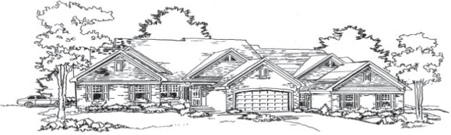
Example of a triplex with a garage for each end unit, accessed from the side. The triplex design includes a number of techniques to provide architectural variety, with materials variety, multi-planed roofline, window treatments, and building modulation.
D. Architectural renderings of the attached units must be submitted with the application. (Ord. 2019-006 § 1 (Exh. A))
18.35.085 Residential types in the lifestyle/multifamily and EOA zoning districts.
A mix of detached single-family housing units, attached dwellings and apartment style buildings may be allowed in the LS/MF and EOA zones through a PRD if the proposal meets the following criteria:
A. The overall site density does not exceed the zoning district maximum or the allowable density bonus (see SMC 18.35.110).
B. The attached units and apartment style building(s) must be clustered and located within the interior of the project, along major street frontages, or other areas which are appropriate and compatible with adjacent land possessing or zoned to accommodate detached single-family development.
C. The attached units must be single-family in appearance (see SMC 18.35.080). This does not apply to apartment style building(s).
D. Architectural renderings of the attached units and apartment style building(s) must be submitted with the application. (Ord. 2019-006 § 1 (Exh. A))
18.35.090 Open space requirements.
Common open space and other appropriate beneficial features are required for all planned residential developments.
A. Open space is intended to benefit the occupants of the planned residential development and will be improved with recreational amenities.
B. The open space design will be appropriate to the size, natural features and topography of the subject site. The design will include open space that is accessible for all residents through pedestrian connections. Further, the open space area(s) will be visible to at least half of the home sites. This may require multiple open space areas.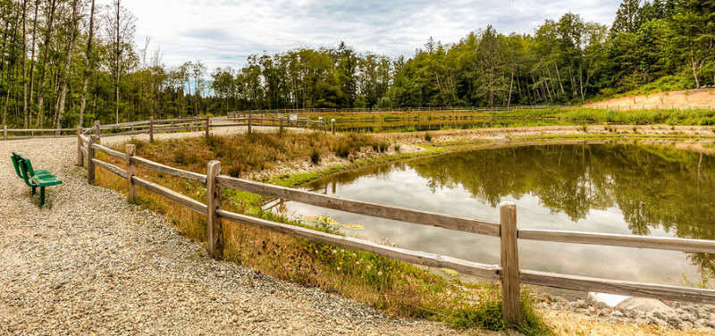
Above: Walking trail, sitting area and stormwater pond used to create active open space.
C. Open space is required based on the average lot size in the proposed development. The greater the deviation from the R4-8 standard lot size, the greater the open space requirement. This relationship is intended to mitigate the effects of smaller lot sizes including reduced recreation space on private lots, reduced setbacks between structures and overall intensity of the development. The required open space is a percentage of the gross project area.
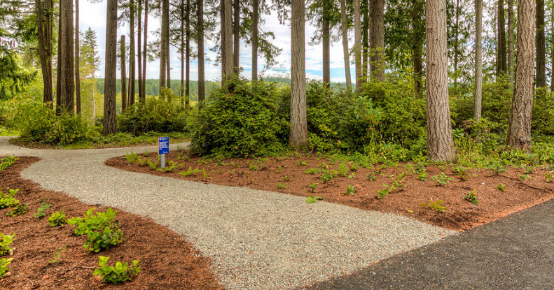
Above: Walking trail in area of retained vegetation used to create active open space.
D. The amount of open space required is set forth in Table 18.35.090.A. The determination of average lot size will be the sum of all individual lot square footage, divided by the total number of proposed lots.
|
Proposed Average Lot Size |
Required Amount of Open Space (of gross project area) |
|---|---|
|
4,499 or smaller |
20% |
|
4,500 – 5,499 |
15% |
|
5,500 – 6,499 |
10% |
|
6,500 – 7,499 |
5% |
E. For PRDs where no individual lots are proposed (i.e., commonly held ownership/condominium), the amount of open space required is tied to the proposed intensity of the PRD, so that as a project increases the number of units, the open space amount also increases in order to compensate for the loss of private yards and privacy, as well as providing for light, air, space, and recreational amenities throughout the PRD design. The amount of open space required will be based upon the number of units as prescribed below:
|
Number of Units |
Required Amount of Open Space (of gross project area) |
|---|---|
|
1 – 40 units |
5% |
|
41 – 80 units |
10% |
|
81 – 110 units |
15% |
|
111 or greater units |
20% |
F. For projects with a combination of individual lots and units on commonly held ownership, total amount of open space required is cumulative. The amount of open space required will be calculated using Tables 18.35.090.A and 18.35.090.B percentage requirements for each respective area (i.e., area(s) of common ownership tract percentage and remainder of site percentage). Each area’s acreage requirement will then be combined for the project’s total open space requirement.
G. Critical area protection areas and required buffers as defined and required by the city’s adopted critical areas ordinance may contribute to the above-required open space amount per the criteria below:
1. If less than 25 percent of the subject site contains protected critical areas and required buffers, then the critical area and protected buffer area may contribute up to 40 percent of the project’s required open space amount, credited on a square-foot-by-square-foot basis.
2. If 25 percent to 40 percent of the subject site contains protected critical areas and required buffers, then the critical area and protected buffer area may contribute up to 50 percent of the project’s required open space amount, credited on a square-foot-by-square-foot basis.
3. If 41 percent or greater of the subject site contains protected critical areas and required buffers, then the critical area and protected buffer area may contribute up to 60 percent of the project’s required open space amount, credited on a square-foot-by-square-foot basis.
H. Stormwater management facilities may contribute to a project’s required open space amount under the following circumstances:
1. For projects that utilize low impact development (LID)1 techniques for their stormwater management, the DCD director may consider on a case-by-case basis to include an area of the LID technique to contribute towards the project’s passive open space requirement. The director must find that the LID technique will beneficially contribute to a project’s open space and/or landscaping and can be maintained and operated as passive open space for this credit to occur.
2. For projects that utilize stormwater vaults, the top of the vault may be proposed to also serve as an active recreational amenity (e.g., sport court), if grade and landscaping provide for a usable area. In such cases, the area proposed to serve as the active amenity can therefore contribute toward the open space requirement.
I. Open space areas not proposed to be improved with recreational amenities or purposes will remain as natural vegetation or landscaped with groundcover, shrubs and trees consistent with the type and location of open space. Natural vegetation removal in preserved and approved open space will only be permitted for public safety reasons and after review and approval of the DCD director and a qualified professional arborist certified by either the International Society of Arboriculture or the National Arborist Association. Enhancement of critical area buffer vegetation will be as allowed and prescribed in Chapter 18.80 SMC, Critical and Environmentally Sensitive Areas Protection. (Ord. 2019-006 § 1 (Exh. A))
18.35.100 Amenities required.
A. Passive and active recreational amenities (owned and maintained by the homeowners) are required to be provided for all PRDs and must be located within the required open space areas.
B. Table 18.35.100 provides guidance on the type of passive and active amenities in proposed PRDs. Other amenities may be permitted at the discretion of the review authority if the applicant can demonstrate the unlisted amenity provides similar purpose and function as those amenities that are listed. At a minimum, the following must be provided:
1. PRDs with 51 or less units must provide at least two Group 1 amenities.
2. PRDs with 52 to 80 units must provide one Group 1 amenity and one Group 2 amenity.
3. PRDs with 81 to 110 units must provide two Group 1 amenities and two Group 2 amenities.
4. PRDs with 111 units or more must provide three Group 1 amenities and two Group 2 amenities.
|
(below amenities can be mixed and matched as long as required number from each group is met) |
|
|---|---|
|
Passive |
Active |
|
Group 1 Amenities |
Group 1 Amenities |
|
Picnic areas with improved seating area and at least 2 picnic tables, in conjunction with an open play area |
Multipurpose sport court or other type of sport court (pickleball, shuffleboard, etc.) |
|
Passive seating areas connected by walking path in a length proportionate to the size of the project |
Basketball court (minimum 1/2 court) |
|
Walking path in a length proportionate to the size of the project |
Tennis court (minimum 1 standard size) |
|
Arboretum/gardens with interpretive trail |
Playground (minimum 0.25 acre) with large toy |
|
Any other comparable passive recreation use as approved by the review authority |
Any other comparable active recreation use as approved by the review authority |
|
Group 2 Amenities |
Group 2 Amenities |
|
Pond/fountain/waterfall with seating for no less than 10 persons |
Outdoor exercise circuit with a trail in a length proportionate to the size of the project |
|
Community gardens with improved soils, fencing and sheds |
Clubhouse including gathering space for intended residents and kitchen facilities |
|
Gazebo connected to gardens or walking paths in a length proportionate to the size of the project |
Large picnic area with covered shelter and multifamily barbecue |
|
Nature interpretive areas/viewing areas with trail and educational signage |
Swimming pool and spa |
|
Any other comparable passive recreation use as approved by the review authority |
Any other comparable active recreation use as approved by the review authority |
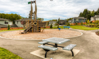
Above: Example of an active recreational feature (children’s play area) and passive feature (picnic table and bench).
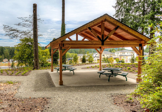
Above: Example of a passive recreational feature (picnic shelter) connected to an active recreational feature (trail system).
C. The location of the recreational amenities will be distributed throughout the PRD for use by all residents unless clustering related amenities will result in recreational opportunities which contribute to the project’s overall recreational plan and provisions (e.g., a playfield located adjacent to a clubhouse, or walking paths and gazebo in conjunction with viewing areas).
D. All PRD amenity design will provide, when feasible, pedestrian linkages and connectivity between adjacent properties. (Ord. 2019-006 § 1 (Exh. A))
18.35.110 Residential density bonus incentives.
The applicant may request an increase in the density permitted by the underlying zoning district in exchange for public benefits through land dedications and facility improvements to help achieve comprehensive plan goals of creation of quality neighborhoods, affordable housing, public facility acquisition and improvement, low impact development techniques, environmentally responsible design, and pedestrian and walkability improvements.
A. The density incentive is expressed as additional bonus dwelling units earned per amount of public benefit provided. When a range is specified, the additional bonus dwelling units will be determined by the DCD director during project review, using the criteria established in Table 18.35.110 for those public benefits.
B. Bonus dwelling units may be earned through any combination from Table 18.35.110; however, bonus units cannot exceed 25 percent increase above maximum density allowed in the underlying zoning district.
C. When bonus dwelling units are proposed, a PRD cannot also include accessory dwelling units within the proposed project.
|
Benefit |
Density Incentive |
|---|---|
|
Affordable Housing |
10 – 25% increase through development agreement consistent with RCW 36.70A.540. |
|
Public Facilities* (public buildings/facilities, trails, parks, and street right-of-way) |
|
|
Dedications: |
|
|
Dedication of land: for public buildings and facilities (such as schools, utilities); public park (consistent with city’s park capital facility plan); public trails; or street right-of-way (in addition to that required by project). Off-site dedications may be considered when acquired by the applicant and dedicated to the city. |
5 – 12% increase above maximum density allowed in underlying zoning district. Range is dependent upon priority and amount of usable acres dedicated. |
|
Improvements: |
|
|
Improvement to city or other agency standards of public buildings and facilities; public parks; public trails and street right-of-way. |
5 – 15% increase above maximum density allowed in underlying zoning district. Range is dependent upon priority, amount and cost of facility improvement. |
|
Inclusion of a number of visible low impact development (LID) measures in project design and stormwater facility construction. |
7% increase above maximum density allowed in underlying zoning district. |
|
Project Design |
|
|
Preservation of substantial vegetation above the required open space amounts. No increase in permitted density will be permitted for sites that have been cleared of evergreen trees and native understory within 5 years prior to the date of application. (Density increases granted which were based upon preservation of existing trees will be forfeited if such trees are removed between time of preliminary plat approval and issuance of building permits.) |
5% increase above maximum density allowed in underlying zoning district. |
|
Retention or creation of a perimeter buffer minimum of 50' in width, composed of existing trees and vegetation, additional plantings, and/or installation of fencing or landscaping. |
1 bonus unit per 250 lineal feet of perimeter buffer retained, enhanced or created. |
|
Enhancement of existing native vegetation, proposed through a landscape plan, and approved by the DCD director and certified arborist or other persons with credentialed expertise. |
5% increase above maximum density allowed in underlying zoning district. |
|
Residential Home Design |
|
|
Inclusion in home design of at least three multi-generational or fully accessible elements, including but not limited to having one entrance without step(s); master bedroom on main floor; 33" doors into bathroom; or other home design elements that can be demonstrated to easily convert into being accessible under the provisions of Americans with Disability Act (ADA). |
5% increase above maximum density allowed in the underlying zoning district when multi-generational elements (as listed in this section) are incorporated into home design; 10% increase above maximum density allowed when home design is fully functional under ADA provisions. Minimum 7% of the pre-density bonus units must be provided to utilize the density. |
|
Home design in which the dwelling units are constructed with Leadership in Energy and Environmental Design (LEED) certification or equivalent standard. |
10% increase above maximum density allowed in underlying zoning district when minimum 7% of the pre-density bonus units are designed with LEED certification or equivalent standard. |
|
Pedestrian Connections and Walkability* |
|
|
Construction of an identified pedestrian/bicycle deficiency** (per city of Sequim capital improvement plan). Improvements may consist of paved shoulder, sidewalk or detached path or walkway depending on adjoining conditions. |
5 – 10% increase above maximum density allowed in underlying zoning district. Range dependent on priority, length and cost of improvement. |
* Dedication of land and construction of improvements under this section are voluntary by the developer and are undertaken for the purpose of achieving a density incentive. For that reason, developers who elect to dedicate land or construct improvements under this section will not be entitled to credit against park or transportation impact fees for the value of such land or improvements.
** In addition to what may be required as part of project review and approval.
(Ord. 2019-006 § 1 (Exh. A))
18.35.130 Submittal requirements.
All applications will be accompanied with complete site plans and subdivision plans if creating lots, drawn to one-inch-to-100-foot scale (other scales may be acceptable depending on the size of the project) and produced in such a way as to clearly indicate compliance with all applicable requirements, and will include the following. At least one sheet will show the proposed project in its entirety (drawn at its appropriate scale).
A. A vicinity map showing the location of the property and surrounding properties. A copy of assessor’s quarter section map may be used to identify the site.
B. Dimensions and orientation of the subject parcel.
C. Location of existing natural features and structures, including: (1) significant stands of trees and trees to be retained (species must be identified; dominant species for stands); (2) topography including identification of geologic hazard areas; (3) any known cultural assets; (4) streams, wetlands and other critical areas or environmental features; (5) aerial photography, if available, of subject site; (6) site and soils analysis for suitability of appropriate low impact development stormwater management facilities; and (7) identification of any adjacent off-site natural features which may have an impact on the subject site, as well as any existing or proposed open space, trail linkages or road connections.
D. Location of proposed lots, building footprints, and open space numbered as open space tracts.
E. Location of walls and fences, indication of their height and construction materials.
F. Elevation of the site at two-foot contour intervals for grades zero to 10 percent and at five-foot contour intervals for grades more than 10 percent.
G. Streets adjacent to, surrounding or intended to serve the property; curb cuts and internal pedestrian and vehicular traffic circulation routes.
H. Existing and proposed exterior lighting.
I. Landscape plan depicting the location and configuration of overall site landscaping, including protected critical areas.
J. Location and layout of off-street parking, on-street parking, and site circulation.
K. Preliminary utility plan depicting the location of utility and drainage facilities and related tracts or easements.
L. Site design for the entire project, including open space areas, pedestrian walkways and connections, recreational amenity details, outdoor features, building footprints and preliminary building elevations and/or general proposed architectural style.
M. Architectural elevations/renderings for any proposed attached unit structures.
N. Environmental checklist or, if required, environmental impact statement.
O. Preliminary draft of restrictive covenants.
P. Other architectural or engineering data which may be necessary to determine compliance with applicable regulations including any appropriate site design guidelines.
Q. Other information may be required as identified at the pre-application conference and/or application form.
R. A written statement explaining how the proposed PRD meets the purpose and findings of this chapter. (Ord. 2019-006 § 1 (Exh. A))
18.35.140 Criteria for approval.
In approving a planned residential development, the review authority must find that the proposal meets all of the following criteria:
A. The proposal, through its design and submitted supporting documents, has clearly demonstrated it meets the stated purposes of this chapter.
B. The proposal complies with all of the applicable provisions of this title, except those provisions from which deviation has been allowed under this chapter and SMC Title 17.
C. The proposal provides overall site design features through its conceptual architectural renderings for the entire project, and has included open space areas, pedestrian walkways and connections, recreational amenities, and outdoor features.
D. The proposal would not impair the integrity and character of the zoning district in which it is to be located.
E. The site is physically suited for the type and intensity of land use(s) being proposed.
F. The proposal would be compatible with existing and future land uses within the general area in which the proposal is to be located by providing screening or buffering between parcels and providing consistency between any existing single-family subdivisions and the proposal.
G. The proposal would preserve natural features and critical areas and would preserve and incorporate existing significant stands of trees (SMC 18.24.032(C)(2)) within the project design as much as possible.
H. There are adequate provisions for water, sanitary sewer, and public utilities (electric, gas, phone) and services to ensure that the proposal would not be detrimental to public health and safety.
I. There will be adequate provisions for public access to serve the subject proposal, as well as providing for neighborhood connectivity as appropriate and as required by the city.
J. The proposal is consistent with the comprehensive plan and the city’s adopted development standards.
K. There will not be significant unmitigated harmful effects upon environmental quality and natural resources.
L. The proposed location, size and design of the proposal would not be detrimental to the public interests, health, safety or welfare of the city. (Ord. 2019-006 § 1 (Exh. A))
18.35.150 Final approval.
A. Within five years following the approval of the planned residential development, the applicant will file with the city engineer a final plat or, if no subdivision is occurring, a final site development plan for review by the review authority. If the review authority finds that the final plat or final site development plan is consistent with the PRD as approved, and that all conditions of the development approval have been satisfied, the review authority will approve the final plat or final site development plan. The review authority may approve the final plat or final site development plan in phases if phasing is included in the original application and each phase does not depend on elements that will be built in another phase. Each phase must be able to stand on its own as if it was a separate project.
B. If the review authority finds evidence of a significant deviation from the original approved PRD, the review authority will advise the applicant to submit an application for amendment of the preliminary plan. An amendment will be considered in the same procedural manner as an original application and the amendments will be heard by the review authority of the initial application.
C. Upon request by the applicant and for demonstrated appropriate reasons, the review authority may approve, at its discretion, adequate financial guarantees of compliance with the final plat or final development plan consistent with Chapter 17.64 SMC.
D. A final draft of covenants, conditions and restrictions (CCRs) will include provisions that the project’s homeowners’ association will own, maintain and enforce all open space tracts, perimeter buffers, fences, recreational amenities, private roads, parking bays, and all other applicable project condition(s) regarding ownership, maintenance and enforcement of all commonly owned elements. Further, the face of the final plat or final development plan must include statement(s) that the project’s homeowners’ association will own, maintain and enforce all open space tracts, perimeter buffers, fences, recreational amenities, private roads, parking bays, and all other commonly owned elements. The city will not join the homeowners’ association as enforcers of the project’s CCRs nor will the city maintain private roads, alleys and other privately owned infrastructure and/or open space or recreational amenities.
E. A final draft of the project’s CCRs and face of the final plat or final development plan must include the following statement:
Open space areas not proposed to be improved with recreational amenities or purposes will remain as natural vegetation or appropriately landscaped. Removal of preserved and approved open space in natural vegetation will only be permitted for public safety reasons and upon review and approval of the DCD Director and a certified arborist or other expert in urban forestry. Enhancement of critical area buffer vegetation will be as allowed and prescribed in SMC 18.80, Critical Areas.
(Ord. 2019-006 § 1 (Exh. A))
18.35.160 Appeals.
The applicant or any interested person may appeal the decision of the review authority as set forth in Chapter 20.01 SMC, Administration of Land Use and Zoning Applications and Development Regulations. (Ord. 2019-006 § 1 (Exh. A))
18.35.170 Extension of time.
A. During City Review of PRD Application.
1. An application found to be technically complete under SMC Title 17 will be deemed null and void if the applicant fails to submit additional information within 180 days of the director’s or hearing examiner’s written request; further, a technically complete application will be deemed null and void if the application has been on hold a combined total of 180 days. If the additional information has not been submitted and accepted by the city, the application will be closed and a new application will be required to be submitted.
2. A technically complete application which has been on hold for a total of 180 days may request one 180-day extension. The extension will be granted if all of the following are met:
a. The applicant requests such an extension in writing no less than 30 days prior to the expiration of the initial 180-day time period. Verbal requests will not be accepted.
b. The director or hearing examiner finds in writing that unusual circumstances beyond the applicant’s control or other good cause has prevented them from providing the additional information within the initial 180-day time period.
c. The applicant demonstrates the likelihood that the requested information will be provided to the city within the additional 180-day time period.
d. The DCD director will not grant more than one extension.
If at the end of the 180-day extension, the additional information has not been submitted and accepted by the city, the application will be closed and a new application will be required to be submitted.
B. After City Permit Approval. Upon written request by the property owner filed no less than 30 days prior to the date of permit expiration, the DCD director may grant an extension of time up to but not exceeding one year. Any extensions of time will be based upon finding:
1. The PRD permit is compliant with all applicable development codes at the time of the extension request.
2. There has been no material change of circumstances applicable to the property since project permit approval.
3. The applicant must provide good cause for the delay, and demonstrate likelihood that the permit will be commenced within the additional year.
4. The DCD director will not grant more than one extension. (Ord. 2019-006 § 1 (Exh. A))
“Low impact development best management practices” means distributed stormwater management practices, integrated into a project design, that emphasize pre-disturbance hydrologic processes of infiltration, filtration, storage, evaporation and transpiration. LID BMPs include, but are not limited to, bioretention, rain gardens, permeable pavements, roof downspout controls, dispersion, soil quality and depth, vegetated roofs, minimum excavation foundations, and water reuse.