


Chapter 18.82
CLEARING AND GRADING
Sections:
18.82.020 Applicability and authority.
18.82.060 Activities exempt from grading permit.
18.82.070 Application submittal requirements.
18.82.080 Financial guarantee.
18.82.090 Performance standards.
18.82.120 Enforcement and violations.
18.82.010 Purpose.
The purpose of this chapter is to:
A. Promote, protect, and preserve the public interest by regulating land alteration, particularly the grading of land in the city;
B. Ensure prompt construction, restoration, replanting, and effective erosion and sedimentation control in properties before, during, and after grading;
C. Prevent water quality degradation and the sedimentation of streams, wetlands, and other water bodies, and preserve natural drainage paths and outfalls;
D. Minimize the impact of runoff, sedimentation, or erosion caused by improper land development and maintenance practices;
E. Promote safety upon public and private property;
F. Promote public health, safety, and welfare. (Ord. 2021-022 § 1 (Exh. A))
18.82.020 Applicability and authority.
A. This chapter sets forth rules and regulations to control grading and earthwork construction, including cuts and fills; establishes the procedures for issuance of permits; and provides for approval of plans, inspections, enforcement, and penalties.
B. The city engineer or designee is authorized to interpret and apply the requirements of this chapter as set forth in SMC 18.82.120 and is responsible for enforcement.
C. The city engineer or designee has the authority to take actions appropriate to implement the provisions of this chapter. (Ord. 2022-029 § 2 (Exh. B), 2022; Ord. 2021-022 § 1 (Exh. A))
18.82.030 Interpretation.
This chapter will be liberally interpreted and construed to secure the public health, safety, and welfare, to implement the city of Sequim comprehensive plan, and to comply with all applicable requirements of Washington State law. The rule of strict construction has no application in this chapter. (Ord. 2021-022 § 1 (Exh. A))
18.82.040 Definitions.
As used in this chapter, unless the context or subject matter clearly requires otherwise, the words or phrases will have the following meanings:
“Applicant” means the property owner or individual person acting on the property owner’s behalf, partnership, association, or corporation applying for a permit to do the work under this chapter, and includes property owners, employees, agents, consultants, contractors, and successors in interest.
“Approval” means approval by the city engineer for the grading permit.
“Backfilling” means returning a site to its original or approved contours after earth materials were removed.
“Best management practices” or “BMPs” means activities, prohibitions of practices, maintenance procedures, and structural and/or managerial practices approved by the city that, when used singly or in combination, prevent or reduce the release of pollutants and other adverse impacts to the waters of Washington State.
“City engineer” means the designated Sequim city engineer or a duly authorized designee.
“Civil engineer” means a professional engineer licensed by the state of Washington in civil engineering.
“Compaction” means the densification or consolidation of earth materials or fill resulting from the weight of overlying deposits or mechanical means.
“Construction” means the building of something, typically a building or structure, but may include underground utilities, surface ponds, etc.
“Cut” means the change of a grade by excavation.
“Development” means land disturbing activity or the addition or replacement of impervious surface for the purpose of subdividing or preparing land for construction. For the purpose of this chapter, routine maintenance activities as described in SMC 18.82.060(C) and (E) are not considered development.
“Earth material” means any rock, soil, or combination thereof.
“Earthwork” means the placement, removal, or movement, or some combination thereof, of earth material either imported, exported, or native, upon a parcel or parcels of land or right(s)-of-way, by artificial means.
“Engineer of record” means a licensed engineer who has overall responsibility for the grading portion of the application, and whose stamp is on the application materials.
“Erosion” means the wearing away of the ground surface as a result of mass wasting or of the movement of wind, water, ice, or other geological agents.
“Excavation” means the physical, manmade removal of earth material.
“Existing grade” means the current surface contour of a site, including minor adjustments to the surface of the site in preparation for construction, or the surface contour that existed immediately prior to grading done without a permit.
“Existing site” means a site prior to any grading activity or any site prior to the passage of the ordinance codified in this chapter.
“Exploratory excavation” means borings or small pits, hand-dug or excavated by mechanical equipment, for the purpose of determining soil characteristics or utility location.
“Fill” means a deposit of earth material placed by artificial means that increases the ground surface elevation.
“Filling” means the activity of depositing fill.
“Finished grade” means the land surface elevation of the site after alterations are completed.
“Geotechnical engineer” means a professional civil engineer licensed by the state of Washington who is qualified by reason of experience and education in the practice of evaluating and predicting the engineering properties of soils and geologic formations or a professional engineering geologist licensed by the state of Washington or a professional licensed civil engineer licensed by the state of Washington who is educated and experienced in evaluating and predicting soil engineering properties and geologic formations.
“Grade” means the vertical elevation of the ground surface.
“Grading” means the excavation, filling, in-place ground disturbance and/or modification, removal of roots or stumps that includes ground disturbance, embankments, stockpiling of earth materials, or any combination thereof, including the establishment of a grade after demolition of a structure.
“Grading permit” means a permit issued by the public works department authorizing land disturbing activity.
“Impervious surface” means a nonvegetated surface area that either prevents or retards the entry of water into the soil mantel as under natural conditions prior to development, or a nonvegetated surface area that causes water to run off the surface in greater quantities or at an increased rate of flow from the flow present under natural conditions prior to development. Common examples include, but are not limited to, rooftops, walkways, patios, driveways, parking lots, storage areas, concrete or asphalt paving, gravel roads, packed earthen materials, and oiled, macadam, or other surfaces that similarly impede the natural infiltration of stormwater.
“Land disturbing activity” means any activity resulting in a movement of earth material, or a change in the existing vegetative or nonvegetative soil cover, or the existing topography. Land disturbing activities include, but are not limited to, tree and stump removal, grading, filling, excavation, or addition of new or the replacement of impervious surfaces. Vegetative maintenance practices such as those described in SMC 18.82.060(C) and (E) are not considered land disturbing activities.
“Permittee” means the person or entity to whom a permit is issued for grading purposes.
“Person” means any individual, partnership, co-partnership, firm, company, corporation, association, joint stock company, trust, estate, government entity, or any other legal entity, or their legal representatives, agents, or assigns. This definition includes all federal, state, or local government entities.
“Preloading” means the temporary stockpiling of earth materials over a site for the purpose of consolidating the existing soils.
“Project permit” or “project permit application” means any land use or environmental permit or license required from a local government for a project action, including but not limited to building permits, subdivisions, binding site plans, planned unit developments, conditional uses, shoreline substantial development permits, site plan review, permits or approvals required by critical area ordinances, site-specific rezones authorized by a comprehensive plan or subarea plan, but excluding the adoption or amendment of a comprehensive plan, subarea plan, or development regulations except as otherwise specifically included in RCW 36.70B.020(4).
“Property owner” means the owner of record for real property as shown on the tax rolls of Clallam County, or a person purchasing a piece of property under contract.
“Review authority” means the person(s) or body responsible for interpreting and/or directing a land use permit or activity, and as set forth in Chapter 20.01 SMC, Administration of Land Use and Zoning Applications and Development Regulations.
“Site” means the defined portion of any lot(s) or parcel(s) of land or contiguous combination thereof, where grading is performed or permitted.
“Slide” means the movement of a mass of loosened rocks or earth down a hillside or slope.
“Slope” means an inclined ground surface, the inclination of which is expressed as a ratio of horizontal distance to vertical distance or as an angle from the horizontal.
“Soil” means a mass of mineral particles, with or without organic constituents, resulting from chemical and mechanical weathering of rock and decomposition of organic matter.
“Terrace” means a relatively level step constructed in the face of a graded slope surface.
“Topsoil” means the weathered surface soil, usually including the organic layer, in which plants have most of their roots. (Ord. 2021-022 § 1 (Exh. A))
18.82.050 Grading permit.
A. Within a 12-month period, projects involving earthwork of more than 50 cubic yards of material or projects that change existing grade by more than four feet must have a valid grading permit before starting any land disturbing activity unless specifically exempt in SMC 18.82.060. The quantity threshold is the total earthwork completed and not the net difference between cut and fill. Grading permit approval must be by the city engineer or authorized designee.
B. Speculative grading is prohibited. A project permit must be approved before a grading permit will be issued, except as otherwise specifically allowed by this chapter.
C. Issued grading permits must be posted on the construction site at all times when work is underway. The appropriate city staff will inspect permitted activities during construction to observe that actual work in the field conforms to the approved plan. The city’s inspection of construction will not create any warranty against defects nor does it relieve the permittee, contractor, and property owner from their obligations to ensure that the work conforms with the approved plan.
D. All grading permit approvals must satisfy the requirements of the city of Sequim stormwater management and erosion control manuals adopted under SMC 13.104.030.
E. In general, grading permits expire one year from the date of issuance unless the specific time limit is identified in the permit’s conditions of approval. The city engineer may impose a time limit in which the proposed site work must be completed based upon weather and/or environmental concerns. The city engineer is authorized to grant one or more written extensions not exceeding 90 calendar days each and specifying the reasons for granting such extension. Extensions must be requested in writing with justifiable cause demonstrated and must include a detailed schedule for completion. (Ord. 2022-017 (Exh. B); Ord. 2021-022 § 1 (Exh. A))
18.82.060 Activities exempt from grading permit.
The following activities are exempt from needing a grading permit. However, the work must comply with and meet the minimum performance standards in SMC 18.82.090. Exempt activities must also provide BMPs as necessary to protect water quality and provide site stability. The public works department will provide the minimum requirements upon request, which requires an adequate and complete written description of the proposed work.
A. An excavation below finished grade for basements, footings of a building retaining wall, or other structure or activity authorized by any valid building permit.
B. Utility trenching within a public right-of-way or upon an easement by a public agency or their designee.
C. Routine maintenance of existing landscaping such as applying new mulch each year, removing weeds, or other similar activities.
D. Emergency situations involving objective, immediate danger to life or property, substantial fire hazards or other public safety hazards if the city engineer gave prior verbal authorization and written authorization communicating the need and verifying the nature of the emergency is provided to the city afterward.
E. Routine agricultural activities such as plowing, harrowing, disking, ridging, listing, leveling, and similar operations to prepare a field or crop.
F. Grading associated with construction of a single-family home with a valid building permit.
G. Limited exploratory excavations under the direction of soils engineers, engineering geologists, or civil engineers licensed in Washington State.
H. Excavation and filling of cemetery graves in an approved cemetery.
I. In any one year, an excavation of less than 50 cubic yards of material that:
1. Is less than one foot in depth; and
2. Does not obstruct a stream or surface water; and
3. Is protected against erosion in accordance with the standards in the Stormwater Management Manual for Western Washington, as adopted and as may be amended.
J. In any one year, a fill of less than 50 cubic yards of material that:
1. Is less than one foot in depth; and
2. Does not obstruct a stream or surface water; and
3. Is not intended to support structures; and
4. Is protected against erosion in accordance with the standards in the Stormwater Management Manual for Western Washington, as adopted and as may be amended.
K. Except for subsections B and D of this section, the exemptions set forth in this section do not apply to activity within critical areas and associated buffers as defined in Chapter 18.80 SMC. See Chapter 18.80 SMC for grading activities restricted in critical areas.
L. Exempt activities as set forth in this section must still provide BMPs as necessary to protect water quality and provide site stability. The public works department will provide the minimum requirements upon request, along with an adequate, written description of proposed work. (Ord. 2021-022 § 1 (Exh. A))
18.82.070 Application submittal requirements.
An application for a grading permit must contain all the following:
A. A completed grading permit application form and all identified submittal requirements.
B. The required application fees.
C. A description of work covered by the permit.
D. An estimate of the quantities of work to be done to include area under application, area to be altered, amount of fill, amount of excavation, impervious area, slope of site.
E. A description of any potential hazards, including but not limited to slides, erosion, siltation, flooding.
F. The signature of the permittee or agent, who may be required to show proof of authority.
G. Completed environmental checklist in compliance with SEPA for nonexempt projects pursuant to WAC 197-11-800. (Note: This requirement may be met with the SEPA checklist/threshold determination for the approved underlying project permit.)
H. Each completed application must be accompanied by the required number of plans and specifications. The plans and specifications must be prepared and stamped by a professional engineer licensed in Washington State. The plans and specifications must be at a scale as prescribed by the city engineer, and include all the following:
1. Existing topographic information with a contour interval of not less than five feet, including identification of any slopes over 30 percent in gradient. Contour intervals must extend a minimum of 100 feet off site.
2. Proposed topographic information, including dimensions, elevations, and finish contours of not greater than five-foot intervals, to be achieved by the proposed grading and related construction.
3. Designation of all critical areas and buffers, tree retention areas, natural vegetation protection areas, or other areas that are not subject to the grading activity.
4. The permanent site stabilization to be established to secure the site upon completion of the grading work.
I. A drainage plan and temporary erosion and sediment control plan that comply with the requirements in Chapter 13.104 SMC, Stormwater Management.
J. Any additional studies required by the city engineer, such as a soils report, in situ soils testing, hydrology report, or geotechnical engineer report, that may be associated with a land development application.
K. Approved grading permit plans must not be amended without prior written authorization from the city engineer. All approved amendments must be identified on the grading permit plans and signed by the city engineer. (Ord. 2021-022 § 1 (Exh. A))
18.82.080 Financial guarantee.
A. All grading permits issued under this chapter and building permits for development that are exempt per SMC 18.82.060(G) but are determined by the city engineer to involve soil disturbing activity to an extent that is potentially damaging to the environment or property must include a financial guarantee as described in subsection B of this section.
B. As a condition of approving the permits identified in subsection A of this section, the city engineer must, in addition to any other permit conditions, require a performance bond in cash or underwritten by a surety company, prepared on a form approved by the city attorney (see Chapter 3.78 SMC). The bond must be posted with the city in an amount not less than 125 percent of the estimated cost as determined by the city engineer. The bond must be sufficient to guarantee performance of any and all slope stabilization, drainage, and erosion control measures specified in the interim erosion control plan required for permits under this section. The bond must also be sufficient so that if such measures are not performed, it will guarantee performance to restore the site to such condition as may be necessary to control erosion and prevent slope destabilization and drainage impacts from the grading work. The release of the bond will occur after the site is stabilized and permanent measures are established in accordance with SMC 18.82.110. (Ord. 2021-022 § 1 (Exh. A))
18.82.090 Performance standards.
A. No grading activity will occur on any site without the written consent of the property owner.
B. All public rights-of-way and easements for roads and utilities must be kept clear of silt, dirt, mud, and debris and immediately cleaned and/or restored to their original condition before the land disturbing activity.
C. Grading boundaries must be marked by flagging, stakes, paint spots, a continuous ribbon, or other readily visible means around the perimeter. Property lines and corners must be clearly identified if grading is to occur within 20 feet of property boundaries. The applicant bears all responsibility for ensuring accuracy of the grading and property boundaries.
1. Open space tracts, tree retention tracts, protected critical areas and buffers, and other areas not subject to grading must be protected from potentially damaging activities. The applicant and/or authorized contractor will:
a. Install visible protective fencing in accordance with SMC 18.80.070.
b. Maintain the protective barriers in place until the city authorizes their removal in writing or a final certificate of occupancy is issued, whichever occurs first.
c. Additional protection during construction consistent with requirements of SMC 18.80.070 may be required by the community development director or designee.
2. Areas proposed for infiltration must be protected during construction and grading activities.
D. Cuts. The slope of cut surfaces must be not steeper than is safe for the intended use, and must be not more than one unit vertical in two units horizontal unless the permittee provides a geotechnical engineering report justifying a steeper slope. Such report must state that a cut at a steeper slope will be stable and not create a hazard to public or private property. The report must be reviewed and approved by the city engineer prior to earthwork. At the city’s sole discretion, the city may require a third-party review of the report, with the permittee bearing the costs of review.
E. Fills.
1. General. Fills must comply with the provisions of this section.
Exceptions:
a. Unless otherwise recommended in the approved geotechnical engineering report.
b. Unless waived by the city engineer for minor fills not intended to support structures. All such waivers must be in writing, adequately identify the reasons for such waiver, and be identified and signed by the city engineer.
2. Surface Preparation. The ground surface must be prepared to receive fill by removing vegetation, noncomplying fill, topsoil, and other unsuitable materials, and scarifying to provide a bond with the new fill.
3. Benching. Where existing grade is at a slope steeper than one unit vertical in five units horizontal and the depth of the fill exceeds five feet, benching must be provided in accordance with Figure 18.82.090A. A key must be provided that is not less than 10 feet in width and two feet in depth.
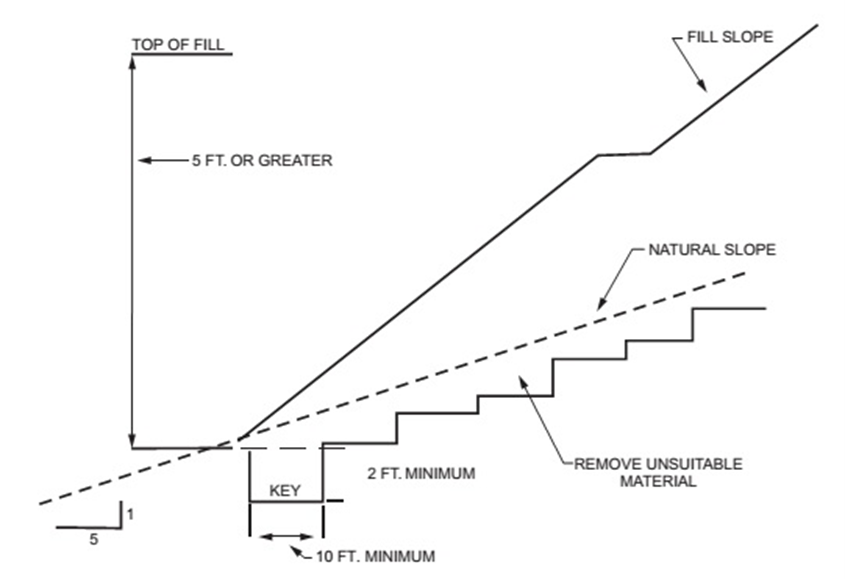
Figure 18.82.090A
4. Fill Material. Organic material is not permitted in fills. In general, rocks or similar irreducible material with a maximum dimension greater than 12 inches must not be used for fill. In limited circumstances the city engineer may permit placement of larger rock when the geotechnical engineer properly devises a method of placement, continuously inspects its placement, and approves the fill stability. All rocks must be placed so as to assure filling of all voids.
5. Compaction. All fill material must be compacted to 90 percent of maximum density as determined by ASTM D1557, Modified Proctor, in lifts not exceeding 12 inches in depth as determined by the approved geotechnical engineer’s report.
6. Maximum Slope. The slope of fill surfaces must be no steeper than is safe for the intended use. Fill slopes steeper than one unit vertical in two units horizontal must be justified by a geotechnical report or engineering data.
F. Setbacks. Cut and fill slopes (including cuts for retaining walls) must be set back from the property lines in accordance with this section. Setback dimensions are measured perpendicular to the property line and are as shown in Figures 18.82.090B and 18.82.090C, unless substantiating data is submitted justifying reduced setbacks.
1. Top of Slope. The setback at the top of a cut slope must be not less than that shown in Figure 18.82.090B, or than is required to accommodate any required interceptor drains, whichever is greater.
2. Slope Protection. Where required to protect adjacent properties at the toe of a slope from adverse effects of the grading, additional protection, approved by the city engineer, must be included. Examples of such protection include but are not limited to:
a. Setbacks greater than those required by Figure 18.82.090B.
b. Provisions for retaining walls or similar construction.
c. Erosion protection of the fill slopes.
d. Provision for the control of surface waters.
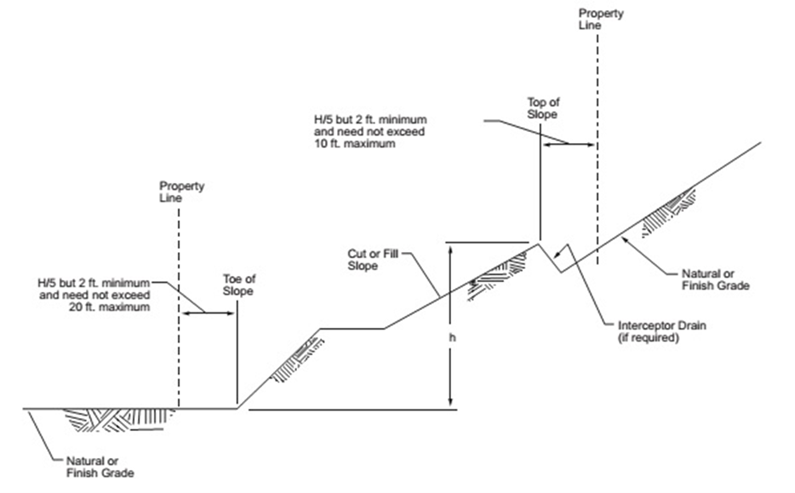
Figure 18.82.090B
Figure 18.82.090C
G. Drainage and Terracing.
1. General. Unless otherwise recommended by a geotechnical engineer, drainage facilities and terracing must be provided in accordance with the requirements of this section. Drainage facilities and terracing must be designed by the geotechnical engineer and be constructed in accordance with the proposed plan and methodology as approved by the city.
Exception: Drainage facilities and terracing need not be provided where the ground slope is not steeper than one unit vertical in three units horizontal.
2. Terraces.
a. Terraces not less than six feet in width must be established at no more than 30-foot vertical intervals on all cut or fill slopes to control surface drainage and debris. Suitable access must be provided to allow for cleaning and maintenance.
b. Where more than two terraces are required, one terrace, located at approximately mid-height, must not be less than 12 feet in width.
c. Swales or ditches must be provided on terraces. They must have a minimum gradient of one unit vertical to 20 units horizontal and must be paved with concrete not less than three inches in thickness, or with other materials suitable to the application. They must have a depth not less than 12 inches and a width not less than five feet.
d. A single run of swale or ditch must not collect runoff from a tributary area exceeding 13,500 square feet (projected) without discharging into a down drain.
3. Interceptor Drains. Interceptor drains must be installed along the top of cut slopes receiving drainage from a tributary width greater than 40 feet, measured horizontally. They must have a minimum depth of one foot and a minimum width of three feet. The slope must be approved by the city engineer, but must be not less than one unit vertical to 50 units horizontal. The drain must be paved with concrete not less than three inches in thickness, or with other materials suitable to the application. Discharge from the drain must be accomplished in a manner to prevent erosion and be approved by the city engineer.
4. Drainage Across Property Lines. Pursuant to Chapter 13.104 SMC, Stormwater Management, drainage across property lines may not exceed that which existed before grading. Excess or concentrated drainage must be contained on site or directed to an approved drainage facility. Erosion of the ground in the area of discharge must be prevented by installation of nonerosive down drains or other devices.
H. Erosion Control. The faces of cut and fill slopes must be prepared and maintained to control erosion. This control is permitted to consist of effective planting. Erosion control for the slopes must be installed as soon as practicable.
I. The city engineer may restrict the timing of grading activities to specific dates when such restrictions are necessary to protect public health or safety, or the environment.
1. During the dry weather period, between May 1st and September 30th, no soils can remain unstabilized for longer than seven consecutive calendar days.
2. During the wet weather period, between October 1st and April 30th, no soils can remain unstabilized for longer than two consecutive calendar days.
3. On or around September 1st, the city will meet with project proponents working under an approved grading permit to discuss the wet weather period and site stabilization requirements. Activity under a permit may be suspended or restricted if conditions pose a threat to the public health, safety, and welfare. Applicant and property owner bear the sole cost of any direct or indirect damage or delays arising from permit suspension or restrictions under this subsection.
J. Grading activities must maintain appropriate working distance from all utilities, including existing drainfields and wells.
K. Grading may be phased or may be required to be phased based on the size, complexity, and risk of the project as determined by the city engineer. Individual phases may be conditioned to be completed and stabilized before work starts on the next phase. All phasing must be described in the plans associated with the approved grading permit.
L. Cultural/Historic Resource Discovery Guidelines. The project proponent and/or their contractors are required to stop work and immediately notify the appropriate contacts at the city of Sequim, the Jamestown S’Klallam Tribe, and the Washington State Office of Archaeology and Historic Preservation if any cultural, historical, or archaeological artifacts are uncovered during development. (Ord. 2022-029 § 1 (Exh. A), 2022)
18.82.100 City inspections.
A. All projects that require a grading permit are subject to city inspection. By submitting a grading application, the applicant and/or property owner grant the city an unlimited right of entry to the work site for purposes of review, making inspections to determine compliance with plans and permit requirements, and taking emergency corrective measures. The cost of such corrective measures will be borne by the permittee. The city may require inspection and testing by an approved testing agency at any stage of the project.
B. Every contractor or other person performing or directing the performance of any work requiring a grading permit must possess an original or copy of the approved grading permit before beginning and during all phases of the work and such persons have a duty to be familiar with the terms and conditions of the permit and approved plans.
C. After investigation, whenever the city determines that the act or intended act of grading has become or will constitute a hazard, endangers property, or adversely affects the safety, use, or stability of a public way, drainage channel, stream, or surface water, including siltation and sedimentation therein, the city may immediately suspend the grading activity. The permittee or agent in control of the grading activity, upon receipt of a verbal or written stop work notice from the city, will immediately stop such grading. (Ord. 2021-022 § 1 (Exh. A))
18.82.110 Work completion.
A. When the rough grading work and the final work authorized under the grading permit are completed, the following drawings and reports may be required by the city engineer:
1. As-graded record drawing prepared and stamped by a civil engineer. The civil engineer must note on the drawing that to the best of the engineer’s knowledge the work was done in accordance with the final approved grading plan.
2. A soils-grading report prepared by the geotechnical engineer, including locations and elevations of field density tests, summaries of field and laboratory tests and other substantiating data and comments on any changes made during grading. The geotechnical engineer must render a finding as to the adequacy of the site for the intended use.
B. The city will complete a final inspection of the grading operation. Final approval will not be given until all work and all erosion control measures have been completed in accordance with the final approved grading plan and any required reports have been submitted.
C. Permanent measures must be implemented to stabilize the site completely. This includes establishing vegetation on exposed soils, installation of stormwater facilities and controls, and other measures as required under the permit. (Ord. 2021-022 § 1 (Exh. A))
18.82.120 Enforcement and violations.
A. The city engineer is authorized with the enforcement of the provisions of this chapter and may designate city employees as authorized representatives to investigate suspected violations and to issue correction notices, stop work notices, and/or notices of infraction.
1. City staff will first post and provide a written correction notice to on-site contractor, permittee, and property owner. The correction notice will include all requirements to achieve compliance and a reasonable time frame for completion. The site must be reinspected to determine if compliance has been achieved or if further action is required.
2. The city engineer may post a stop work order on site and provide a copy to permittee and property owner. All site work must stop once a stop work order has been posted except for items necessary to achieve compliance and ongoing erosion and sediment maintenance activities. Stop work order fees must be paid in accordance with adopted fee schedule, Chapter 3.68 SMC.
B. Violators of the provisions of this chapter and/or the grading permit conditions of approval are liable for all damages, including, without limitation, all enforcement costs and reasonable attorney’s fees, to public property arising from such violation, including the cost of restoring the affected area to its condition before such violation. With respect to public property, the city engineer may give written approval for restoration to a condition acceptable to the city that differs from the condition immediately before the violation. The city may hire, at its sole discretion, an appropriately licensed expert to provide a written restoration report. All costs associated with preparing such a report are the sole responsibility of the property owner.
1. Restoration must include but not be limited to the replacement of all improperly removed materials and the removal of improper fill and stabilization of slopes.
2. Restoration must also include installation and maintenance of interim and emergency erosion control measures until such time as the restored groundcover and vegetation reach sufficient maturation to function.
3. No further work will be allowed until the property is fully restored or permitted in compliance with this chapter and requirements of the city engineer.
C. The violation of any provision of this chapter or grading permit condition, where such violation constitutes a first offense, constitutes a civil infraction or a civil penalty. The city engineer may issue a notice of infraction or notice of penalty in accordance with Chapters 8.04 and 1.13 SMC, respectively. Any person who has been found to have committed five or more civil violations pursuant to this chapter within the past five years will be deemed to have committed a misdemeanor and is subject to criminal prosecution and a fine in a sum not exceeding $1,000 or imprisonment for a term not exceeding 90 calendar days, or both. Every day of continued noncompliance with a notice and order or order enforced in accordance with this chapter or any of the code provisions that incorporate this chapter by reference is a separate offense (SMC 1.13.210(A)).
D. Despite any provision of this chapter, the city engineer may take immediate action to prevent an imminent and substantial danger to the public health, safety, or the environment by the violation of any provision of this chapter.
E. In addition to any other remedy provided in this section, the city engineer may, but without obligation, seize any financial guarantee deposited with the city pursuant to SMC 18.82.080 and take such steps as are necessary to provide interim erosion control, slope stabilization, and control of drainage as required in any interim erosion control plan upon the failure of the permittee to comply with such plan. If the costs associated with the steps described in this subsection exceed the amount of the financial guarantee, the remainder may be assessed as a lien against the property. Within 30 calendar days, the city will refund any remaining funds from the financial guarantee after all steps described in this subsection have been taken and all other local, state, and federal obligations have been met, including but not limited to any liens, subcontractor payments, taxes, insurance, and other monetary liabilities. In either instance, the city will provide an accounting of all costs incurred to the permittee and the property owner. (Ord. 2021-022 § 1 (Exh. A))