Chapter 17.15
GEOLOGICALLY HAZARDOUS AREAS
Sections:
17.15.010 Erosion hazard areas criteria.
17.15.015 Landslide hazard areas criteria.
17.15.025 Restrictions on building.
17.15.035 Assessments and reports.
17.15.040 Geological assessments.
17.15.045 Geotechnical reports.
17.15.050 Existing geotechnical reports.
17.15.005 Purpose.
The purpose of this chapter is to protect, preserve and enhance areas that are sensitive to human activities, including steep slopes, and landslide and erosion hazard areas. Additionally, the purpose of this chapter is to regulate development in geologically hazardous areas and associated buffers to avoid unstable slopes and adverse impacts to such areas and adjacent upslope and downslope areas.
(Ord. 343 § 1, 2002).
17.15.010 Erosion hazard areas criteria.
Erosion hazard areas are identified by the presence of vegetative cover, soil texture, slope, and rainfall patterns, or human-induced changes to such characteristics, which create site conditions vulnerable to erosion.
(Ord. 343 § 1, 2002).
17.15.015 Landslide hazard areas criteria.
Landslide hazard areas are those areas meeting any of the following criteria:
A. Areas of historic failures, including areas of old and recent landslides;
B. Areas with both of the following characteristics:
1. Slopes steeper than 15 percent; and
2. Hillsides intersecting geologic contacts with a relatively permeable sediment overlying a relatively impermeable sediment or bedrock.
C. Slopes that are parallel or subparallel to planes of weakness, such as bedding planes, joint systems, and fault planes, in subsurface materials;
D. Slopes having a gradient steeper than 80 percent subject to rock fall during seismic shaking;
E. Areas potentially unstable as a result of rapid stream incision, stream bank erosion, and undercutting by wave action;
F. Areas located in a canyon or on an active alluvial fan, presently or potentially subject to inundation by debris flows or catastrophic flooding;
G. Any area with a slope of 30 percent or steeper and with a vertical relief of 10 or more feet. A slope is delineated by establishing the toe and top and measured by averaging the inclination over at least 10 feet of vertical relief;
H. Areas that have a “severe” limitation for building site development because of slope conditions, according to the National Resource Conservation Service.
(Ord. 343 § 1, 2002).
17.15.020 Mapping.
Mapping. Landslide and erosion hazard areas meeting the criteria established above are delineated on hazard maps created by the Department. The actual presence or absence of landslide or erosion hazard areas shall be determined by field conditions and the classification criteria listed above.
(Ord. 343 § 1, 2002).
17.15.025 Restrictions on building.
Restrictions on Building. In areas meeting both of the following characteristics no structure or disturbance of vegetation is permitted:
A. An area with a slope of 100 percent or steeper (45 degrees); and
B. Hillsides intersecting geological contacts with a relatively permeable sediment overlying a relatively impermeable sediment or bedrock.
(Ord. 343 § 1, 2002).
17.15.030 Exemptions.
In addition to the exemptions contained in UPMC 17.10.035, the following activities shall be exempt from the requirements of this chapter.
A. Trimming and Limited Cutting of Trees. Any person wishing to engage in clearing activity pursuant to this exemption shall arrange a site visit with Department staff. Staff shall issue a letter of exemption if the proposed activity is consistent with the intent of this chapter and provided:
1. The applicant can clearly demonstrate the activity will not result in a detrimental impact to the landslide or erosion area on or off site;
2. Groundcover shall be retained and the ground surface shall not be disturbed;
3. The clearing activity does not exceed the provisions of the City Zoning Code.
4. The trimming and cutting of trees is consistent with the vegetation conservation requirements specified in UPMC 18.25.100 for properties subject to the Shoreline Master Program provisions in UPMC Title 18.
(Ord. 630 § 1 (Exh. A), 2013; Ord. 343 § 1, 2002).
17.15.035 Assessments and reports.
Regulation. For all regulated activities proposed within landslide and erosion hazard areas, a geotechnical report shall be submitted. The requirements for a geotechnical report shall be waived where the applicant can clearly demonstrate to the department through submittal of a geological assessment that the regulated activity will not occur within the landslide or erosion hazard area.
(Ord. 343 § 1, 2002).
17.15.040 Geological assessments.
A geological assessment shall be prepared by a professional engineer licensed by the State of Washington with expertise in geotechnical engineering or by a professional geologist/hydrologist or soils scientist who has earned a bachelor’s degree in geology, hydrology, soils science, or closely related field from an accredited college or university, or equivalent educational training, and has five years’ experience assessing erosion and landslide hazards. The geological assessment shall include at a minimum the following:
A. A description of the topography, surface and subsurface hydrology, soils, geology, and vegetation of the site; and
B. An evaluation of the analysis area’s inherent landslide and erosion hazards; and
C. A site plan of the area delineating all portions of the site subject to landslide and erosion hazards based on mapping and criteria referenced in this chapter.
D. The submittal must include a contour map of the proposed site at a scale of one inch = 20 feet or as deemed appropriate by the Department. Slopes shall be clearly identified and differentiated for the ranges between 15 and 29 percent, and 30 percent or greater.
(Ord. 343 § 1, 2002).
17.15.045 Geotechnical reports.
The geotechnical report shall be prepared by a professional engineer licensed by the State of Washington with experience in geotechnical engineering and shall address the existing geologic, topographic, and hydrologic conditions on a site, including an evaluation of the ability of the site to accommodate the proposed activity. Geotechnical reports shall include an analysis of the impacts that a regulated activity may have on adjacent properties. The geotechnical report shall include at a minimum the following:
A. Site Geology Information Required.
1. Topographic Data. Submittal must include a contour map of the proposed site, at a scale of one inch = 20 feet or as deemed appropriate by the Department. Slopes shall be clearly identified and differentiated for the ranges between 15 and 29 percent, and 30 percent or greater, including figures for aerial coverage of each slope category on the site. When site-specific conditions indicate the necessity, the Department may require the topographic data to be field surveyed.
2. Subsurface data. Submittal must include boring logs and exploration method, soil and rock stratigraphy, ground water levels and seasonal changes of ground water levels.
3. Site history. Submittal must include a description of any prior grading, soil instability, or slope failure.
4. Seismic hazard. Submittal of data concerning the vulnerability of the site to seismic events.
B. Geotechnical Engineering Information Required.
1. Slope stability studies and opinion(s) of slope stability;
2. Proposed angles of cut and fill slopes and site grading requirements;
3. Structural foundation requirements and estimated foundation settlements;
4. Soil compaction criteria;
5. Proposed surface and subsurface drainage;
6. Lateral earth pressures;
7. Vulnerability of the site to erosion;
8. Suitability of on-site soil for use as fill;
9. Laboratory data and soil index properties for soil samples; and
10. Building limitations including setback recommendations.
11. Analysis of any potential landslide run-out associated with the hazard area.
C. Performance Standards. All geotechnical reports shall contain a section that addresses each of the performance standards identified in UPMC 17.15.055.
D. Impacts on Adjacent Properties. Geotechnical reports shall address any impacts to adjacent properties that may result from the proposed regulated activity. Reports shall address both short-term (during construction) impacts and long term (post construction) impacts. All such impacts shall be mitigated per subsection (E) of this section.
E. Mitigation Recommendations. Geotechnical reports shall include a section that identifies mitigation measures necessary to preserve the stability of geologically hazardous and adjacent areas.
(Ord. 343 § 1, 2002).
17.15.050 Existing geotechnical reports.
Where a geotechnical report has been prepared within the last five years for a specific site, and where the proposed land use activity and surrounding site conditions are unchanged, the report may be utilized and a new report may not be required. If any changed environmental conditions are associated with the site, or surrounding the site, the applicant shall submit an amendment to the geotechnical report.
(Ord. 343 § 1, 2002).
17.15.055 Regulation.
A. Department Approval. The development proposal may be approved, approved with conditions, or denied based on the Department’s evaluation of the geotechnical report, including, but not limited to:
1. The ability of the proposed mitigation or engineering measures to reduce risks to the proposed structure and risks to the erosion or landslide hazard area; and adjacent property; and
2. The proposed development’s conformance with the following performance standards:
a. Location and Extent of Development.
(1) Development shall be located to minimize disturbance and removal of vegetation; and
(2) Structures shall be clustered where possible to reduce disturbance and maintain natural topographic character; and
(3) Structures shall conform to the natural contours of the slope and foundations should be tiered where possible to conform to existing topography of the site.
b. Design of Development.
(1) All development proposals shall be designed to minimize the building footprint and other disturbed areas; and
(2) All development shall be designed to minimize impervious lot coverage; and
(3) Roads, walkways and parking areas shall be designed to parallel the natural contours; and
(4) Access shall be in the least sensitive area of the site, as feasible.
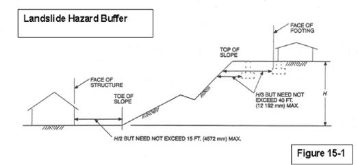
B. Buffer Requirement. A buffer, consisting of undisturbed natural vegetation and measured (as shown in Figure 15-1) in a perpendicular direction from all landslide and erosion hazard areas, shall be required. The buffer shall be required from the top of slope and toe of slope of all landslide or erosion hazard areas that measure 10 feet or more in vertical elevation change from top to toe of slope. The minimum buffer distance requirements from the top of slope and toe of slope of landslide or erosion hazard areas shall be the same as for setbacks from slopes as identified in the International Building Code, as amended from time to time. Regulated uses/activities that occur outside the buffer required by this subsection, the setback required by subsection (C) of this section, and any potential landslide run-out do not require a geotechnical report. The other provisions of this chapter shall apply.
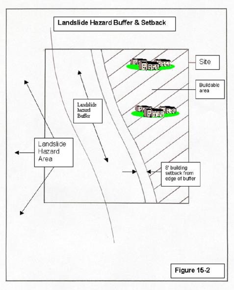
C. Building Setback and Construction Adjacent to Buffer. Eight-foot minimum setback lines (as shown in Figure 15-2) shall be required from the buffer area required in this section for construction of any impervious surface(s) greater than 120 square feet of base coverage. Clearing, grading, and filling within the eight-foot setback shall only be allowed when the applicant can demonstrate that vegetation within the buffer will not be damaged. The setback is required in addition to the buffer regardless of buffer width, except as provided in subsection (D) of this section.
D. Modifications and Flexibility. Alteration of a geologically hazardous area or an associated buffer or buffer setback may occur where:
1. A geotechnical report has been submitted showing, to the satisfaction of the City, that the proposal will have no adverse impact on the stability or erosion susceptibility of the adjacent hazardous slope area. A modified slope, a reduced or eliminated buffer, and/or a reduced or eliminated setback shall not be permitted unless the proposed design, engineering and mitigation measures pertaining to any modifications within a landslide or erosion hazard area adequately reduce risk to proposed structures, to or from landslide and erosion hazard areas, and to adjacent areas. Should the geotechnical report indicate that a greater buffer than that required by this section is needed to meet the intent of this chapter, the greater buffer shall be required;
2. The impacted area of disturbance totals no more than 20 percent of the project site;
3. The modification will not increase surface water discharge or sedimentation to adjacent properties beyond predevelopment conditions;
4. The activity will not adversely impact other critical areas as regulated in this title or shorelands as regulated in UPMC Title 18;
5. The development will not decrease slope stability on adjacent properties;
6. Stormwater runoff from any new impervious surface is managed and accommodated through LID design to the extent practicable. Where LID design will not fully manage and accommodate this stormwater, at the discretion of the City it shall be directed to the City’s storm drainage system or collected in a detention system and directed to an enclosed drainage system; and
7. For slopes of 40 percent or greater, the following conditions also apply:
a. The disturbed area is not connected to or associated with a larger ravine system, the Puget Sound shoreline or Chambers Creek Canyon bluffs; and
b. The slope is the result of human-caused activities, including regrading through mining, excavation and/or filling.
E. Buffer Protection. To increase the functional attributes of the buffer, the Department may require that the buffer be enhanced through planting of indigenous species. The edge of the buffer area shall be clearly staked, flagged, and/or fenced prior to any site clearing or construction. The buffer boundary markers shall be clearly visible, durable, and permanently affixed to the ground. Site clearing shall not commence until the applicant has submitted written notice to the Department that buffer requirements of this chapter are met. Field marking shall remain until all construction and clearing phases are completed, and the Department has granted final project approval. Prior to final approval for subdivisions, short subdivisions binding site plans, planned development districts and commercial developments the buffer and slope shall be placed in a separate critical area tract or tracts, protective easement, public or private land trust dedication, or similarly preserved through an appropriate permanent protective mechanism as determined by the Department. All protected areas identified above shall remain undeveloped in perpetuity, except as they may be altered pursuant to this title.
F. Temporary Erosion and Sedimentation Control Plan. Temporary erosion and sedimentation control plans shall be required for all regulated activities in landslide and erosion hazard areas. The temporary erosion and sedimentation control plan shall be consistent with the City’s Public Works Standards and must be implemented prior to the start of development activity on site.
(Ord. 670 § 1 (Exh. A), 2016; Ord. 343 § 1, 2002).
17.15.060 Title notification.
The owner of any site within a landslide hazard area shall record a notice with the Pierce County Auditor on a form provided by the Department, and generally in the form set forth below. This notice shall be in addition to any other title notification statement required by this title, although any such notices may be combined.
Owner(s) on his/her own behalf and on behalf of his/her heirs, successors and assigns hereby waives any right to assert any claim against the City for any loss, or damage to people or property either on or off the site resulting from soil movement by reason of or arising out of issuance of the permit(s) by the City for development on the property except only for such losses that may directly result from the sole negligence of the City. Furthermore, the City makes no promise that in the event of soil movement that adversely affects abutting streets or utilities that such streets or utilities will be restored following such soil movement.
(Ord. 343 § 1, 2002).