


Chapter 18.20
SHORELINE JURISDICTION AND DESIGNATIONS
Sections:
18.20.010 Shoreline jurisdiction.
18.20.020 Official shoreline map.
18.20.030 Shoreline environment designations.
18.20.010 Shoreline jurisdiction.
A. The provisions of the Shoreline Program shall apply to all shorelines of the State, all shorelines of Statewide significance and shorelands as defined in RCW 90.58.030 and this Shoreline Program. These areas are collectively referred to herein as “shorelines.”
B. The City shall have authority over those shorelines that meet the criteria of RCW 90.58.030 for “shorelines of the State” within its municipal boundaries, and where such boundary or any part thereof is adjacent to or fronting on any bays, lakes, sounds, rivers, or other navigable waters, the powers and jurisdiction of the City are hereby extended into and over such waters and over any tidelands intervening between any such boundary and any such waters to the middle of such bays, sounds, lakes, rivers, or other waters in every manner and for every purpose that such powers and jurisdiction could be exercised if the waters were within the City limits.
C. “Shorelines of the State” are the total of all “shorelines” and “shorelines of Statewide significance” within the State. Within University Place, this includes:
1. Marine Waters.
a. Those waters of Puget Sound lying between extreme low tide and the ordinary high water mark, and adjacent marine shorelands.
b. Chambers Bay Estuary and its associated wetlands, floodway and shorelands.
2. Streams.
a. Chambers Creek and its associated wetlands, floodway and shorelands.
3. Shorelines of Statewide Significance.
a. Those waters of Puget Sound lying seaward of extreme low tide.
(Ord. 652 § 1 (Exh. A), 2015).
18.20.020 Official shoreline map.
A. Shoreline Environment Designations have been established and are delineated on the “City of University Place Shoreline Map” (Shoreline
Map) hereby incorporated as a part of this Shoreline Program. The official copy of this map shall reside with the Washington State Department of Ecology. Additional copies are available at the City of University Place Planning and Development Services Department for public use.
B. The Shoreline Map identifies shoreline environment designations and the approximate extent of shoreline jurisdiction within City boundaries. The map depicts, at a generalized level, the lateral extent of shoreline jurisdiction or associated wetlands and floodplains. The precise lateral extent of shoreline jurisdiction shall be determined on a case-by-case basis at the time a shoreline development is proposed. The actual extent of shoreline jurisdiction requires a site-specific evaluation to identify the location of the ordinary high water mark (OHWM) and associated wetlands and/or floodplains.
C. Where uncertainty or conflict occurs in the exact location of a shoreline designation boundary, the Administrator shall interpret the boundaries based upon:
1. Boundaries indicated as approximately following lot, tract, or section line shall be so construed;
2. Boundaries indicated as approximately following roads or railways shall be construed to follow their centerlines; or
3. Boundaries indicated as approximately parallel to or extensions of features indicated in subsection (C)(1) or (2) of this section shall be so construed.
D. Whenever existing physical features are inconsistent with boundaries on the Shoreline Map, the Administrator shall interpret the boundaries, with deference to actual conditions. Appeals of such interpretations may be filed pursuant to the applicable appeal procedures described in Chapter 22.10 UPMC.
E. In the event of a mapping error, the City will rely upon common boundary descriptions and the criteria contained in RCW 90.58.030(2) and Chapter 173-22 WAC pertaining to determinations of shorelands, as amended, rather than the incorrect or outdated map.
(Ord. 652 § 1 (Exh. A), 2015).
18.20.030 Shoreline environment designations.
This section sets forth the purpose, designation criteria, and management policies for the five shoreline environment designations established in this Shoreline Program. Areas within shoreline jurisdiction that are not mapped and/or designated are automatically assigned an Urban Conservancy environment designation until the shoreline can be re-designated through a Shoreline Master Program amendment. General boundaries for each shoreline environment are illustrated in Figures 1 and 2, and summarized, below:
Marine Deepwater: Areas waterward of the intertidal shorelines of Puget Sound delineated by the - 10 MLLW line;
Natural: Water portions of Chambers Creek extending to the centerline and shorelands located east of the Section 28/Section 29 line, Township 20 North, Range 2 East, excluding Kobayashi Park;
Urban Conservancy: Kobayashi Park, those portions of Chambers Creek Properties abutting the Chambers Bay estuary and Puget Sound, the BNSF ROW, and residential properties abutting the BNSF ROW located adjacent to Puget Sound. Also, aquatic zones on that portion of Chambers Creek to the center line fronting Kobayashi Park; aquatic zones on the Chambers Creek properties, BNSF ROW and residential properties fronting the ROW; and the waters to the middle of Chambers Bay and to the -10 MLLW line along Puget Sound.
Shoreline Residential: Day Island and Sunset Beach residential neighborhoods and those lands/waters extending out to the -10 MLLW line and the center of the Day Island waterway; and
Day Island Medium Intensity: Existing marinas, mixed use and yacht club properties abutting the Day Island waterway and those lands/waters extending out to the -10 MLLW line and the center of the Day Island waterway.
A. Marine Deepwater Environment.
1. Purpose. The purpose of the Marine Deepwater environment is to protect and manage the unique characteristics and resources of the areas waterward of the intertidal shoreline. Although not a WAC designated environment designation, the Marine Deepwater environment has been established by the City to address concerns with activities that are anticipated to occur only in deep water marine areas such as dredge and mooring buoys.
2. Designation Criteria. The Marine Deepwater Environment shall apply to all marine waters and underlying submerged lands between the -10-foot MLLW line and the center of the waterway.
3. Management Policies. In addition to the other applicable policies and regulations of this Shoreline Program, the following management policies shall apply:
a. All developments and uses on navigable waters and submerged lands should be located and designed to minimize interference with surface navigation, to reduce impacts to public views, and to allow for the safe, unobstructed passage of fish and wildlife, particularly those species dependent on migration.
b. Uses that adversely impact the ecological functions of critical saltwater habitats should not be authorized except where necessary to achieve the objectives of RCW 90.58.020, and then only when all potential impacts are mitigated as necessary to assure maintenance of shoreline ecological functions and processes.
c. Shoreline uses and modifications should be designed and managed to prevent degradation of water quality and alteration of natural conditions. New over-water structures should only be authorized for water-dependent uses, public access, or ecological restoration. The size of new over-water structures should be limited to the minimum necessary to support the structure’s intended use. To reduce the impacts of shoreline development and increase effective use of water resources, multiple uses of the same over-water facility should be encouraged.
B. Natural Environment.
1. Purpose. The purpose of the Natural environment is to protect those shoreline areas, specifically associated with Chambers Creek, that are relatively free of human influence or that include intact or minimally degraded shoreline functions intolerant of human use. These systems require that only very low-intensity uses be allowed in order to maintain the ecological functions and ecosystem-wide processes. Consistent with the policies of the designation, the City should include planning for restoration of degraded shorelines within this environment.
2. Designation Criteria. The Natural environment designation shall be assigned to shoreline areas if any of the following characteristics apply:
a. The shoreline is ecologically intact and therefore currently performing an important, irreplaceable function or ecosystem-wide process that would be damaged by human activity.
b. The shoreline is considered to represent ecosystems and geologic types that are of particular scientific and educational interest; or
c. The shoreline is unable to support new development or uses without significant adverse impacts to ecological functions or risk to human safety.
3. Management Policies. In addition to the other applicable policies and regulations of this Shoreline Program, the following management policies shall apply:
a. Any use or modification that would substantially degrade the ecological functions or natural character of the Chambers Creek shoreline area should not be allowed.
b. Non-water-oriented uses shall be highly restricted and generally limited to low-intensity, passive uses subject to conditional use permit approval.
c. New single-family residential development may be allowed as a conditional use within the natural environment if the development is located outside of the vegetation conservation area and if the density and intensity of such use is limited as necessary to protect ecological functions and be consistent with the purpose of the environment.
d. Structures, parking areas and associated infrastructure should be located outside of shoreline jurisdiction unless there is no practicable alternative.
e. Scientific, historical, cultural, educational research uses, walking/hiking trails, and low-intensity water-oriented recreational access uses may be allowed; provided, that no significant ecological impact on the area will result.
f. New development or significant vegetation removal that would reduce the capability of vegetation to perform normal ecological functions should not be allowed. The subdivision of property should not be allowed when the configuration will require significant vegetation removal or shoreline modification that adversely impacts ecological functions. Each new parcel must be able to support its intended development without significant ecological impacts to the shoreline function.
4. Management Policies – Aquatic Zone. In addition to the other applicable policies and regulations of this Shoreline Program, the following management policies shall apply to areas waterward of the ordinary high water mark:
a. All developments and uses on the waters of Chambers Creek should be located and designed to reduce impacts to public views and to allow for the safe, unobstructed passage of fish and wildlife, particularly those species dependent on migration.
b. Uses that adversely impact the ecological functions of habitats associated with Chambers Creek should not be authorized except where necessary to achieve the objectives of RCW 90.58.020, and then only when all potential impacts are mitigated as necessary to assure maintenance of shoreline ecological functions and processes.
c. Shoreline uses and modifications should be designed and managed to prevent degradation of water quality and alteration of natural conditions. New over-water structures should only be authorized for public access or ecological restoration. The size of new over-water structures should be limited to the minimum necessary to support the structure’s intended use.
C. Urban Conservancy Environment.
1. Purpose. The purpose of the Urban Conservancy environment is to protect and restore ecological functions of open space, flood plain and other sensitive lands where they exist in urban and developed settings, while allowing a variety of compatible uses including residential development. An additional purpose is to protect, restore and manage the unique characteristics and resources of the areas between the ordinary high water mark and the -10-foot MLLW line adjacent to upland Urban Conservancy areas.
2. Designation Criteria. The Urban Conservancy environment designation shall be applied to shoreline areas appropriate and planned for development that is compatible with maintaining or restoring of the ecological functions of the area, which are not generally suitable for water-dependent uses, if any of the following characteristics apply:
a. Shoreline areas are suitable for water-related or water-enjoyment uses.
b. Shoreline areas are open space, flood plain or other sensitive areas that should not be more intensively developed.
c. Shoreline areas have potential for ecological restoration.
d. Shoreline areas retain important ecological functions, even though partially developed; or
e. Shoreline areas have the potential for development that is compatible with ecological restoration.
3. Management Policies. In addition to the other applicable policies and regulations of this Shoreline Program, the following management policies shall apply:
a. Uses that preserve the natural character of the area or promote preservation of open space, floodplain or critical areas either directly or over the long term should be the primary allowed uses. Where lawfully established residential structures exist within shoreline jurisdiction, residential uses and activities that are compatible with the purpose of the Urban Conservancy Environment and do not result in significant impacts to ecological functions may be considered a primary allowed use. Uses that result in the restoration of ecological functions should be allowed if the use is otherwise compatible with the purpose of the Urban Conservancy environment and the physical characteristics of the setting.
b. Buffers, shoreline stabilization limitations, water quality measures, and vegetation conservation or enhancement measures should be used to regulate and inform the design of the proposed use or development and ensure that it does not result in a net loss of shoreline ecological functions or degrade other shoreline values.
c. Public access, including walking/hiking trails, should be provided whenever feasible and significant ecological impacts can be avoided or mitigated.
d. A variety of recreational uses as established by the Comprehensive Plan, Zoning Code, Chambers Creek Properties Master Site Plan and this Shoreline Program, should be allowed where the development of such uses is done in a manner that protects or enhances shoreline ecological functions.
e. Water-oriented uses should be given priority over non-water-oriented uses.
f. New over-water structures should be prohibited except for water-dependent uses, public access, or ecological restoration.
g. The size of new over-water structures should be the minimum necessary to support the structure’s intended use.
h. Uses that adversely impact the ecological functions of critical saltwater habitats should not be authorized except where necessary to achieve the objectives of RCW 90.58.020, and then only when all potential impacts are mitigated as necessary to assure maintenance of shoreline ecological functions and processes.
i. Residential uses that preserve the natural character of the area, maintain shoreline vegetation buffers and/or promote preservation of open space, floodplains or sensitive lands, either directly or over the long term, should be allowed. Residential development should be authorized only:
(1) When adequate setbacks or buffers are provided to protect shoreline ecological functions;
(2) Where there is adequate access, infrastructure and public services; and
(3) Where the environment can support the proposed use or development in a manner which protects, enhances, or restores ecological functions.
j. The rights of navigation should be protected.
4. Management Policies – Aquatic Zone. In addition to the other applicable policies and regulations of this Shoreline Program, the management policies in UPMC 18.20.030(A)(3) shall apply to areas waterward of the ordinary high water mark.
D. Shoreline Residential Environment.
1. Purpose. The purpose of the Shoreline Residential environment is to accommodate residential development and appurtenant structures that are consistent with this Shoreline Program. Additional purposes are to provide public access and recreational uses, and to protect, restore and manage the unique characteristics and resources of the areas between the ordinary high water mark and the -10-foot MLLW line adjacent to upland Shoreline Residential areas.
2. Designation Criteria. The Shoreline Residential environment designation shall be applied to shoreline areas if they are predominantly single-family or multifamily residential development or are planned and platted for residential development.
3. Management Policies. In addition to the other applicable policies and regulations of this Shoreline Program, the following management policies shall apply:
a. Land division and development should be authorized only:
(1) When adequate setbacks or buffers are provided to protect shoreline ecological functions;
(2) Where there is adequate access, infrastructure and public services; and
(3) Where the environment can support the proposed use or development in a manner which protects, enhances, or restores ecological functions.
b. Multifamily residential development and subdivisions of land into more than four parcels should provide public access to the shoreline and joint use for recreational facilities.
c. Development (including expansion of existing structures) should be located and designed so that shoreline stabilization is not needed, to the extent practicable, either at the time of development/expansion or in the future.
d. Vegetation conservation measures should be utilized for new development and expansions to existing structures to protect, enhance or restore shoreline areas.
e. Water-oriented recreational uses should be allowed.
f. New over-water structures should be prohibited except for water-dependent uses, public access, or ecological restoration.
g. The size of new over-water structures should be the minimum necessary to support the structure’s intended use.
h. In order to reduce the impacts of shoreline development and increase effective use of water resources, multiple use of over-water facilities should be encouraged.
i. Uses that adversely impact the ecological functions of critical saltwater habitats should not be authorized except where necessary to achieve the objectives of RCW 90.58.020, and then only when all potential impacts are mitigated as necessary to assure maintenance of shoreline ecological functions and processes.
j. The rights of navigation should be protected.
4. Management Policies – Aquatic Zone. In addition to the other applicable policies and regulations of this Shoreline Program, the management policies in UPMC 18.20.030(A)(3) shall apply to areas waterward of the ordinary high water mark.
E. Day Island Medium Intensity Environment.
1. Purpose. The purpose of the Day Island Medium Intensity environment is to accommodate marinas, yacht clubs with boat moorage and related facilities and activities, water-oriented commercial, transportation and light industrial uses, and moderate density residential uses within mixed use projects, while protecting existing ecological functions and restoring ecological functions in areas that have been previously degraded. Additional purposes are to provide public access to the shoreline and recreational uses oriented toward the waterfront, to accommodate non-water-oriented uses on a limited basis where appropriate, and to protect, restore and manage the unique characteristics and resources of the areas between the ordinary high water mark and the -10-foot MLLW line. The intent of the Day Island Medium Intensity environment is similar to that of a High Intensity Environment as described in WAC 173-26-211 except that development intensities are to be limited to those consistent with the Comprehensive Plan designation and zoning classification for the area.
2. Designation Criteria. The Day Island Medium Intensity environment shall be assigned to shoreline areas that currently support a mix of uses related to commerce, industry, transportation or navigation, recreation, and moderate density housing; or are suitable and planned for medium- intensity water-oriented uses.
3. Management Policies. In addition to the other applicable policies and regulations of this Shoreline Program, the following management policies shall apply:
a. The shoreline abutting the Day Island Lagoon is characterized by a variety of urban uses and activities, including commercial, light industrial, marina, residential, and recreational uses. Together, these uses and activities have the potential to create a vibrant shoreline that is consistent with and supportive of University Place’s character and quality of life. These types of uses should be allowed within the Day Island Medium Intensity environment, with preference given to water-oriented uses.
b. Non-water-oriented uses should not be allowed except as part of mixed use development that is predominantly water-oriented in terms of use.
c. The redevelopment and renewal of substandard and degraded shoreline areas should be encouraged. Future development of these areas should include restoration and/or enhancement of degraded shorelines and the provision of public access to the shoreline.
d. Where feasible, public access should be provided in accordance with WAC 173-26-221(4)(d).
e. Aesthetic objectives should be implemented by means such as sign control regulations, appropriate development siting, screening and architectural standards, and maintenance of natural vegetative buffers.
f. All development and use on navigable waters and submerged lands should be located and designed to minimize interference with navigation, reduce impacts to public views, and to allow for the passage of fish and wildlife, particularly those species dependent on migration.
g. Uses that adversely impact the ecological functions of critical saltwater habitats should not be authorized except where necessary to achieve the objectives of RCW 90.58.020, and then only when all potential impacts are mitigated as necessary to assure maintenance of shoreline ecological functions and processes.
h. Improvements to water quality and sediment transport within the Day Island Lagoon should be given high priority. Such improvements may occur in conjunction with development proposals that require mitigation or as part of a voluntary restoration project.
i. New over-water structures should be prohibited except for water-dependent uses, public access, or ecological restoration.
j. The size of new over-water structures should be the minimum necessary to support the structure’s intended use.
4. Management Policies – Aquatic Zone. In addition to the other applicable policies and regulations of this Shoreline Program, the management policies in UPMC 18.20.030(A)(3) shall apply to areas waterward of the ordinary high water mark.
FIGURE 1 – SHORELINE ENVIRONMENT DESIGNATIONS – PUGET SOUND NORTH AND DAY ISLAND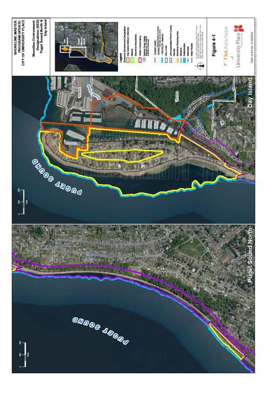
FIGURE 2 – SHORELINE ENVIRONMENT DESIGNATIONS – PUGET SOUND SOUTH AND CHAMBERS CREEK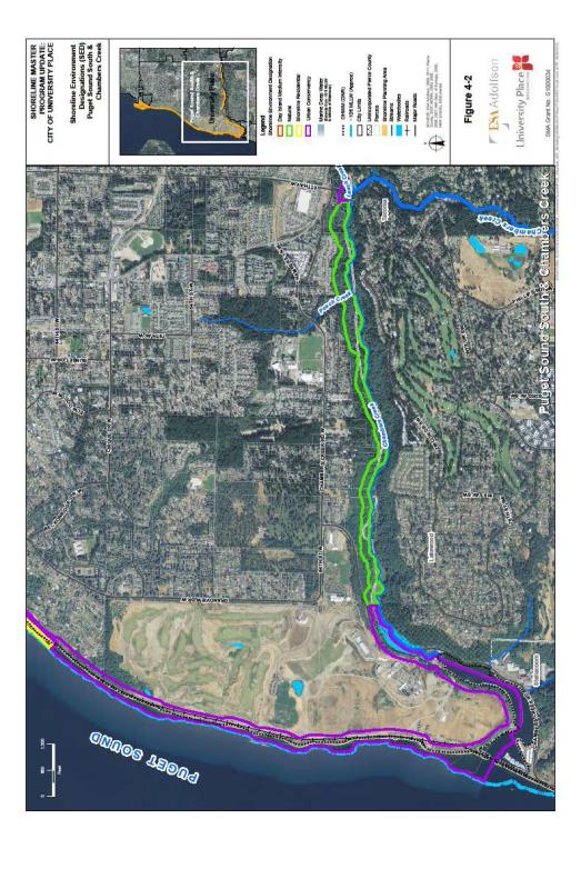
(Ord. 652 § 1 (Exh. A), 2015).